Brenner Basistunnel im Bau Brenner Base Tunnel under Construction
Brenner Basistunnel im Bau Brenner Base Tunnel under Construction
Brenner Basistunnel im Bau Brenner Base Tunnel under Construction

Sie wollen auch ein ePaper? Erhöhen Sie die Reichweite Ihrer Titel.
YUMPU macht aus Druck-PDFs automatisch weboptimierte ePaper, die Google liebt.
18 Österreich/Italien<br />
Austria/Italy<br />
<strong>Tunnel</strong> 1/2012<br />
<strong>Brenner</strong> <strong>Basistunnel</strong><br />
<strong>im</strong> <strong>Bau</strong><br />
Die <strong>Bau</strong>phase – Phase 3 – be<strong>im</strong> <strong>Brenner</strong> <strong>Basistunnel</strong><br />
wurde am 18. April 2011 gestartet. Der<br />
folgende Beitrag gibt einen Überblick über den<br />
bisherigen Stand der Arbeiten.<br />
<strong>Brenner</strong> <strong>Base</strong> <strong>Tunnel</strong><br />
<strong>under</strong> <strong>Construction</strong><br />
Phase 3 – the construction phase – of the <strong>Brenner</strong><br />
<strong>Base</strong> <strong>Tunnel</strong> was started on 18 th April 2011.<br />
The following article gives an overview of the<br />
state of the art of construction.<br />
Univ. Prof. Dipl.-Ing. Dr. Dr. Konrad Bergmeister, <strong>Brenner</strong> <strong>Basistunnel</strong> BBT SE,<br />
Innsbruck/A, konrad.bergmeister@bbt-se.com, www.bbt-se.com<br />
1 Allgemeines zum<br />
<strong>Basistunnel</strong><br />
Der <strong>Brenner</strong> <strong>Basistunnel</strong> ist <strong>im</strong><br />
neuen TEN-Strategieplan (2014<br />
bis 2020) als Teil des Nord-Süd-<br />
Korridors Nr. 5 Helsinki – Valletta<br />
(Sizilien) vorgesehen. Derzeitig<br />
ist der <strong>Brenner</strong> <strong>Basistunnel</strong><br />
als prioritäres Teilstück des TEN-<br />
Bahnkorridors von Berlin nach<br />
Palermo ausgewiesen.<br />
Be<strong>im</strong> <strong>Brenner</strong> <strong>Basistunnel</strong><br />
wurde die Phase 3 am 18. April<br />
2011 durch einen Beschluss<br />
der Gesellschafterversammlung<br />
(50 % ÖBB und 50 % TFB:<br />
davon 82 % RFI – italienische<br />
Eisenbahngesellschaft und<br />
18 % Länder: Südtirol, Trentino,<br />
Verona) gestartet.<br />
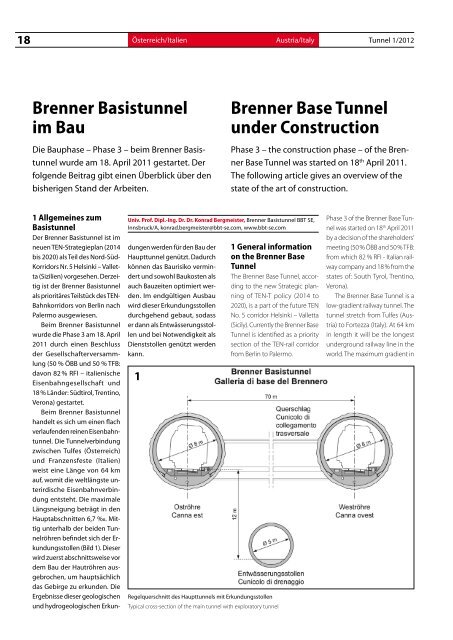
Be<strong>im</strong> <strong>Brenner</strong> <strong>Basistunnel</strong><br />
handelt es sich um einen flach<br />
verlaufenden reinen Eisenbahntunnel.<br />
Die <strong>Tunnel</strong>verbindung<br />
zwischen Tulfes (Österreich)<br />
und Franzensfeste (Italien)<br />
weist eine Länge von 64 km<br />
auf, womit die weltlängste unterirdische<br />
Eisenbahnverbindung<br />
entsteht. Die max<strong>im</strong>ale<br />
Längsneigung beträgt in den<br />
Hauptabschnitten 6,7 ‰. Mittig<br />
unterhalb der beiden <strong>Tunnel</strong>röhren<br />
befindet sich der Erkundungsstollen<br />
(Bild 1). Dieser<br />
wird zuerst abschnittsweise vor<br />
dem <strong>Bau</strong> der Hautröhren ausgebrochen,<br />
um hauptsächlich<br />
das Gebirge zu erkunden. Die<br />
Ergebnisse dieser geologischen<br />
und hydrogeologischen Erkundungen<br />
werden für den <strong>Bau</strong> der<br />
Haupttunnel genützt. Dadurch<br />
können das <strong>Bau</strong>risiko vermindert<br />
und sowohl <strong>Bau</strong>kosten als<br />
auch <strong>Bau</strong>zeiten opt<strong>im</strong>iert werden.<br />
Im endgültigen Ausbau<br />
wird dieser Erkundungsstollen<br />
durchgehend gebaut, sodass<br />
er dann als Entwässerungsstollen<br />
und bei Notwendigkeit als<br />
Dienststollen genützt werden<br />
kann.<br />
1<br />
Regelquerschnitt des Haupttunnels mit Erkundungsstollen<br />
1 General information<br />
on the <strong>Brenner</strong> <strong>Base</strong><br />
<strong>Tunnel</strong><br />
The <strong>Brenner</strong> <strong>Base</strong> <strong>Tunnel</strong>, according<br />
to the new Strategic planning<br />
of TEN-T policy (2014 to<br />
2020), is a part of the future TEN<br />
No. 5 corridor Helsinki – Valletta<br />
(Sicily). Currently the <strong>Brenner</strong> <strong>Base</strong><br />
<strong>Tunnel</strong> is identified as a priority<br />
section of the TEN-rail corridor<br />
from Berlin to Palermo.<br />
Typical cross-section of the main tunnel with exploratory tunnel<br />
Phase 3 of the <strong>Brenner</strong> <strong>Base</strong> <strong>Tunnel</strong><br />
was started on 18 th April 2011<br />
by a decision of the shareholders‘<br />
meeting (50 % ÖBB and 50 % TFB:<br />
from which 82 % RFI - Italian railway<br />
company and 18 % from the<br />
states of: South Tyrol, Trentino,<br />
Verona).<br />
The <strong>Brenner</strong> <strong>Base</strong> <strong>Tunnel</strong> is a<br />
low-gradient railway tunnel. The<br />
tunnel stretch from Tulfes (Austria)<br />
to Fortezza (Italy). At 64 km<br />
in length it will be the longest<br />
<strong>under</strong>ground railway line in the<br />
world. The max<strong>im</strong>um gradient in
<strong>Tunnel</strong> 1/2012<br />
Die wichtigsten Kenndaten des<br />
<strong>Brenner</strong> <strong>Basistunnel</strong>s sind:<br />
• Länge: 55 + 9 = 64 km<br />
• Längsneigung: 5,0 bis 6,7 ‰<br />
• Scheitelhöhe des <strong>Basistunnel</strong>s:<br />
795 m ü.d.M.<br />
• Nettoquerschnitt der<br />
Haupttunnel mit baulicher<br />
Toleranz – konventioneller<br />
Vortrieb: 40,4 m 2<br />
• Nettoquerschnitt der<br />
Hauptunnel mit baulicher<br />
Toleranz – maschineller<br />
Vortrieb: 42 m 2<br />
• Abstand der Querschläge:<br />
300 m<br />
2 Planungen<br />
2.1 Projektübergreifende<br />
Regelplanung – Guide Design<br />
Damit die Planung der verschiedenen<br />
<strong>Bau</strong>lose einheitlich erfolgt<br />
und die UVP-Vorschriften<br />
eingeplant werden können,<br />
wird be<strong>im</strong> <strong>Brenner</strong> <strong>Basistunnel</strong><br />
vor der Ausschreibungsbzw.<br />
Ausführungsplanung<br />
eine projektübergreifende<br />
Regelplanung (guide design)<br />
erstellt. Diese wird auf Basis<br />
des aktuellen Wissens und der<br />
neuesten technologischen Entwicklungen<br />
durchgeführt, um<br />
eine einheitliche technische<br />
Grundlage für die weiteren<br />
Ausschreibungs- und Planungsschritte<br />
zu schaffen. In einer internationalen<br />
Expertengruppe<br />
wurden die unterschiedlichen<br />
Erfahrungen mit Großprojekten<br />
und deren Abwicklungsmodalitäten<br />
ausgewertet und<br />
in der Folge ein Vorschlag für<br />
den <strong>Brenner</strong> <strong>Basistunnel</strong> ausgearbeitet.<br />
Dadurch soll eine<br />
homogene und solide Basis für<br />
die Folgeplanungen erarbeitet<br />
werden.<br />
Durch die Unterschiedlichkeit<br />
der Planungsphilosophien<br />
und der länderspezifischen<br />
Vorgaben soll <strong>im</strong> Rahmen der<br />
Regelplanung eine einheitliche<br />
Vorgangsweise zur geotechnischen<br />
Klassifizierung vorbereitet<br />
werden. Dabei fließen<br />
auch die Kennwerte aus den<br />
Ergebnissen des Erkundungsstollens<br />
ein. Gezielt sollen die<br />
Auswahlparameter festgelegt<br />
und die Berechungsparameter<br />
bzw. –methoden wie Squeezing,<br />
Gebirgskriechen, elastoplastische<br />
Stabilität, Deformationen<br />
etc. soweit als möglich<br />
festgelegt werden.<br />
Die wesentlichen Elemente dieser<br />
gesamtheitlichen Regelplanung<br />
sind:<br />
• Überarbeitung der Trassierung<br />
mit Einarbeitung<br />
sämtlicher Opt<strong>im</strong>ierungen<br />
und UVP-Vorschriften<br />
• Normative Grundlagen und<br />
technische Vorgaben für<br />
die losbezogene Ausschreibungs-<br />
und Ausführungsplanung<br />
• Einheitliche Bewertungsmatrix<br />
für die geotechnische<br />
Klassifizierung auf<br />
der Grundlage italienischer<br />
SIG(1997)- und österreichischer<br />
ÖGG-Richtlinien<br />
• Grundsätze für die Bemessung,<br />
die konstruktive<br />
Durchbildung für eine Lebensdauer<br />
von 200 Jahren<br />
• Erstellen von detaillierten<br />
Schnittstellen- und Typenplänen<br />
• Toleranzvorgaben (vermessungs-<br />
und baumethodenabhängige<br />
Toleranzen)<br />
unter Berücksichtigung der<br />
Folgegewerke<br />
• Vorkehrungen für den<br />
bahntechnischen Ausbau<br />
Zusätzlich wird die gesamte<br />
Trassierung vom UTM in ein<br />
projektbezogenes Koordinatensystem<br />
BBT-TM gebracht,<br />
das durch eine transversale<br />
Mercatorprojektion erzeugt<br />
The future<br />
of mobility<br />
Messe Berlin GmbH<br />
Messedamm 22 · 14055 Berlin · Germany<br />
Tel. +49(0)30/3038-2376 · Fax +49(0)30/3038-2190<br />
innotrans@messe-berlin.de<br />
InnoTrans 2012<br />
International Trade Fair for Transport Technology<br />
Innovative Components · Vehicles · Systems<br />
18 – 21 September · Berlin · Germany<br />
www.innotrans.com
20 Österreich/Italien<br />
Austria/Italy <strong>Tunnel</strong> 1/2012<br />
wird. Damit wird die mittlere<br />
Projekthöhe von 720 m orthometrischer<br />
Höhe festgelegt,<br />
was ca. 770 m ellipsoidischer<br />
Höhe entspricht. Das Projekt<br />
liegt somit in einem Gebiet ca.<br />
10 km östlich und westlich vom<br />
Mittelmeridian. In diesem Fall<br />
beträgt die Streckenverzerrung<br />
weniger als 2 bis 3 mm/km. Im<br />
so geschaffenen Bezugssystem<br />
muss keine weitere Rotation<br />
durchgeführt werden, da die<br />
Meridiankonvergenz einfach<br />
zu berechnen ist und der sich<br />
daraus ergebende Reduktionseffekt<br />
auf die Richtungen<br />
unbedeutend ist (der Konvergenzwinkel<br />
beträgt ca. 4’).<br />
2.2 Ausschreibungs- bzw.<br />
Ausführungsplanungen<br />
Im Jahre 2012 erfolgen die Ausschreibungen<br />
für die externen<br />
Dienstleistungen zu den Ausschreibungs-<br />
und Ausführungsplanungen.<br />
Im <strong>Bau</strong>zeitplan<br />
sind 2 Hauptausschreibungen<br />
für die Ausschreibungs- bzw.<br />
Ausführungsplanung vorgesehen<br />
und zwar eine für den<br />
österreichischen Abschnitt<br />
(Erkundungsstollen, Haupttunnel<br />
ausgehend von den<br />
<strong>Bau</strong>stellen Ahrental und Wolf)<br />
sowie eine für den italienischen<br />
Abschnitt (Erkundungsstollen,<br />
Haupttunnel ausgehend von<br />
der <strong>Bau</strong>stelle Mauls). Die Planungen<br />
der Randbaulose (Einbindung<br />
Bahnhof Innsbruck,<br />
Rettungsstollen Umfahrung<br />
Innsbruck, Eisackunterquerung<br />
und Bahnhof Franzensfeste)<br />
und später der bahntechnischen<br />
Ausrüstung erfolgen<br />
gesondert. Durch die Vergabe<br />
der Ausschreibungs- und Ausführungsplanungen<br />
an denselben<br />
Planer soll gewährleistet<br />
werden, dass die Erkenntnisse<br />
aus dem Erkundungsstollenprogramm<br />
möglichst vollständig<br />
in die Planungen der<br />
Haupttunnellose einbezogen<br />
werden können.<br />
In Österreich wird auf der<br />
Grundlage der ÖGG-Richtlinien<br />
und der ÖNORM B 2118 zur Ausschreibung<br />
der <strong>Tunnel</strong>baulose<br />
eine Ausschreibungsplanung<br />
mit den wesentlichen Projektelementen<br />
und einer detaillierten<br />
Leistungsbeschreibung erstellt<br />
und dann baubegleitend<br />
die Ausführungsplanung erarbeitet.<br />
In Italien wird auf der Grundlage<br />
des staatlichen Dekretes<br />
DM 163/2006 zur Ausschreibung<br />
der <strong>Bau</strong>lose eine detaillierte<br />
Ausführungsplanung<br />
erstellt und baubegleitend<br />
Detailpläne erarbeitet.<br />
3 Erkenntnisgewinn<br />
durch Modells<strong>im</strong>ulationen<br />
3.1 Geo-hydrogeologische<br />
Modellierung<br />
Nördlich des <strong>Brenner</strong>s finden<br />
wir zwischen dem Innsbrucker<br />
Quarzphyllit und den Zentralgneisen<br />
des <strong>Brenner</strong>s den<br />
sogenannten „Bündner Schiefer“.<br />
Es handelt sich dabei um<br />
ein durch die Entstehung der<br />
Alpen aus Meeressed<strong>im</strong>enten<br />
entstandenes feinkörniges<br />
Gestein. Ein charakteristisches<br />
Merkmal stellen die ausgeprägten<br />
Schieferungsflächen<br />
dar. Die Gesteine kommen<br />
hauptsächlich als dunkelgrauer<br />
„Schwarzphyllit“ vor, der<br />
sich mit kalkreichen Phylliten<br />
abwechselt.<br />
Die geplante <strong>Tunnel</strong>trasse<br />
quert <strong>im</strong> Valser- und Pfitschtal<br />
den Aquifer des Hochstegenmarmors.<br />
Aufgrund der hohen<br />
Bedeutung dieses Aquifers<br />
wurde ein auf das <strong>im</strong> Hochstegenmarmor-Grundwasserfließsystem<br />
beschränktes 2-<br />
D-S<strong>im</strong>ulationsmodell erstellt.<br />
the main sections of the tunnel<br />
amounts to 6.7 ‰. The exploratory<br />
tunnel is centred beneath<br />
the 2 tunnels (Figure 1). It will be<br />
built in sections before beginning<br />
construction works on the<br />
main tubes, mainly to examine<br />
and prospect the rock. The results<br />
of these geological and hydrogeological<br />
tests will be used<br />
for the construction of the main<br />
tunnel. This reduces construction<br />
risk and opt<strong>im</strong>izes construction<br />
costs and t<strong>im</strong>e. The final outfitting<br />
will be realized in the whole<br />
exploratory tunnel with the result<br />
that it can be converted into<br />
a drainage tunnel and, if need be,<br />
to a service gallery.<br />
The most <strong>im</strong>portant basic features<br />
of the <strong>Brenner</strong> <strong>Base</strong> <strong>Tunnel</strong><br />
are:<br />
• Length: 55 + 9 = 64 km<br />
• Gradient: 5.0 to 6.7 ‰<br />
• Apex height of the base<br />
tunnel: 795 m a.s.l.<br />
• Net cross-section of the<br />
main tunnel with structural<br />
tolerance – conventional<br />
tunnelling: 40.4 m 2<br />
• Net cross-section of the<br />
main tunnel with structural<br />
tolerance – mechanical<br />
tunnelling: 42 m 2<br />
• Distance between the connecting<br />
side tunnels: 300 m<br />
2 Planning<br />
2.1 Cross border planning<br />
design – guide design<br />
Prior to the planning for tender<br />
procedures and the <strong>im</strong>plementation<br />
planning, a cross border guide<br />
design has to be drawn up, so<br />
that the planning of the different<br />
lots takes place uniformly and the<br />
EIA prescriptions can be included<br />
in the planning. It is based on the<br />
current level of knowledge and<br />
the newest technological developments<br />
and represents the<br />
point of departure for further<br />
planning for tender procedures<br />
and other planning steps. The<br />
different experiences obtained in<br />
<strong>im</strong>portant projects and their methods<br />
of management and execution<br />
were assessed by a group<br />
of international experts and a proposal<br />
was subsequently created<br />
for the <strong>Brenner</strong> <strong>Base</strong> <strong>Tunnel</strong>. This<br />
approach a<strong>im</strong>s to elaborate a homogenous<br />
and solid foundation<br />
for further planning activities.<br />
Due to the differences in the<br />
design philosophies and the<br />
country-specific requirements<br />
a uniform procedure should be<br />
prepared within the planning design<br />
for geotechnical classification.<br />
Incorporating the characteristic<br />
values from the results of the<br />
exploratory tunnel. Target should<br />
be determining the selection parameters<br />
– and methods: as far as<br />
possible determining squeezing,<br />
rock creep, elasto-plastic stability,<br />
deformation, etc.<br />
The key elements of such an “end<br />
to end” planning design are:<br />
• Route planning review and<br />
adoption of all opt<strong>im</strong>ization<br />
measures and of the EIA<br />
prescriptions<br />
• Normative foundations<br />
and technical prescriptions<br />
for tender procedures and<br />
<strong>im</strong>plementation planning<br />
for every lot<br />
• Uniform evaluation matrix<br />
for the geotechnical classification<br />
based on the Italian<br />
SIG (1997) and Austrian ÖGG<br />
guidelines<br />
• Assessment principles, constructional<br />
design pattern for<br />
a working life of 200 years<br />
• Preparation of detailed<br />
interface and type plans<br />
• Definition of tolerances<br />
(tolerances depending on<br />
measurement and construction<br />
methods) considering<br />
subsequent constructions
<strong>Tunnel</strong> 1/2012<br />
<strong>Brenner</strong> <strong>Basistunnel</strong> <strong>im</strong> <strong>Bau</strong><br />
21<br />
Geologischer Längsschnitt mit <strong>Tunnel</strong><br />
Geological longitudinal section of tunnel<br />
2<br />
Ziel dieser Modellierung ist es,<br />
einerseits Erkenntnisse über<br />
eventuelle Auswirkungen einer<br />
Grundwasserabsenkung durch<br />
die Drainagewirkung der <strong>Tunnel</strong>röhren<br />
zu gewinnen und<br />
andererseits die Wirkungsmechanismen<br />
von Abdichtungen<br />
in Bezug auf möglichst geringe<br />
Absenkungen des Grundwasserspiegels<br />
zu studieren (Bild 2).<br />
Da die Durchlässigkeiten<br />
der benachbarten Gesteinseinheiten<br />
geringer sind als jene des<br />
Hochstegenmarmors und somit<br />
ein Zu- oder Abstrom in die benachbarten<br />
Gesteinseinheiten<br />
hydrogeologisch vernachlässigbar<br />
ist, wurde eine 2-D-Modellierung<br />
durchgeführt. Das<br />
Modellgebiet beschränkt sich<br />
auf die Grundwasserleiter des<br />
Hochstegenmarmors und der<br />
quartären Talfüllungen. Als Modellfläche<br />
wurde der gesamte<br />
Bereich des hydrogeologischen<br />
Modellschnittes mit der Grundwasserscheide<br />
<strong>im</strong> Norden und<br />
der hydraulisch dichten <strong>Brenner</strong>abschiebung<br />
am Südrand<br />
ausgewählt. Die Modellbasis<br />
stellt einen hydraulisch dichten<br />
Rand dar. Die Modelltiefe wurde<br />
mit -500 m ü .A. angenommen.<br />
Unterhalb dieser Höhe ist von<br />
keiner hydraulischen Wegigkeit<br />
mehr auszugehen. Das Modellgebiet<br />
wird von den <strong>Tunnel</strong>röhren<br />
durchörtert, weshalb sie in<br />
der Modellierung als Querschnitte<br />
dargestellt werden.<br />
Die Schichtlagerung des<br />
Hochstegenmarmors weist ein<br />
Einfallen von 30° bis 45° nach<br />
Nordosten auf. Für die Modellbildung<br />
wurde der Hochstegenmarmor<br />
in die Vertikale projiziert.<br />
Um die für die Berechnung<br />
der Grundwasserströmungsverhältnisse<br />
erforderlichen realen<br />
Höhen beizubehalten, wurde<br />
das durch die Drehung überhöhte<br />
Profil dem tatsächlichen<br />
Geländeprofil angepasst.<br />
Für die Talaquifere wurde<br />
entsprechend ihrer lithologischen<br />
Zusammensetzung die<br />
in Tabelle 1 aufgeführte kf-Zonierung<br />
(10 Zonen) vorgenommen.<br />
In dieser Tabelle findet<br />
sich auch eine Auflistung der<br />
restlichen Modellparameter.<br />
• Preparatory measures for the<br />
railway equipment installation<br />
Additionally, the whole route<br />
planning is recorded in a<br />
project co-ordination system:<br />
BBT-TM, represented as a transverse<br />
Mercator projection. The<br />
average project altitude of 720<br />
m of orthometric height is defined,<br />
which corresponds to an<br />
approx<strong>im</strong>ate ellipsoidal height<br />
of 770 m. The project area is thus<br />
situated in the area about 10 km<br />
to the east and west of the central<br />
meridian. In the present case,<br />
the track distortion is less than 2<br />
to 3 mm per km.<br />
In the reference system thus<br />
created, no further rotations are<br />
necessary, as the meridian convergence<br />
is s<strong>im</strong>ple to calculate<br />
and the consequent reduction<br />
effect on directions is irrelevant<br />
(the convergence angle is approx<strong>im</strong>ately<br />
4‘).<br />
2.2 Tender procedures and<br />
<strong>im</strong>plementation planning<br />
The tenders for external services<br />
to the tender procedure and <strong>im</strong>plementation<br />
planning will take<br />
place in 2012. There are 2 major<br />
tenders provided in the construction<br />
schedule for the tender<br />
procedure and <strong>im</strong>plementation<br />
planning, namely one for the<br />
Austrian section (exploratory<br />
tunnel, main tunnel starting from<br />
the construction sites Ahrental<br />
and Wolf ) and one for the Italian<br />
section (exploratory tunnel, main<br />
tunnel starting from the Mauls<br />
construction site). The planning<br />
of the boundary lots (integrating<br />
Innsbruck Station, rescue tunnel<br />
Innsbruck by-pass, Eisack crossing<br />
and Franzensfeste Station)<br />
and later the railway technical<br />
equipment take place separately.<br />
By the allocation of the tender<br />
procedure and <strong>im</strong>plementation<br />
planning to the same planner it<br />
should be ensured that the findings<br />
from the exploratory tunnel<br />
program can be integrated as<br />
fully as possible in the planning<br />
of the main tunnel lot.<br />
In Austria, a tender procedure<br />
planning with the major project<br />
elements and a detailed service<br />
description will be created on
22 Österreich/Italien<br />
Austria/Italy <strong>Tunnel</strong> 1/2012<br />
Bezeichnung Zone Parameter Wert nach Variationen Variationsbreite<br />
Hochstegenmarmor 1 kf 2,5 x 10 -7 m/s 1 x 10 -7 - 1 x 10 -6 m/s<br />
Wildlahnertal Hang-, Verwitterungschutt 2 kf 5 x 10 -5 m/s 1 x 10 -6 - 1 x 10 -5 m/s<br />
Valsertal Alluvion 3 kf 1 x 10 -4 m/s 1 x 10 -4 - 1 x 10 -5 m/s<br />
Valsertal Bänderton 4 kf 1 x 10 -8 m/s 1 x 10 -8 - 1 x 10 -6 m/s<br />
Fluviogalziale Sed<strong>im</strong>ente 5 kf 1 x 10 -6 m/s 1 x 10 -6 - 1 x 10 -5 m/s<br />
Valsertal Tillite 6 kf 1 x 10 -8 m/s 1 x 10 -8 - 1 x 10 -7 m/s<br />
Venntal Tillablagerungen 7 kf 1 x 10 -4 m/s 1 x 10 -4 - 1 x 10 -7 m/s<br />
Silltal Alluvion 8 kf 1 x 10 -7 m/s 1 x 10 -7 - 1 x 10 -4 m/s<br />
Silltal Bändertone 9 kf 1 x 10 -7 m/s 1 x 10 -8 - 1 x 10 -7 m/s<br />
Wipptal Bänderton 10 kf 1 x 10 -5 m/s 1 x 10 -8 - 1 x 10 -5 m/s<br />
Durchlässigkeit der Bachbetten (Leakage factor) c 1 x 10 -4 1/s 1 x 10 -6 - 1 x 10 -3 1/s<br />
Grundwasserneubildung r 357 mm/a 262 - 514 mm/a<br />
<strong>Tunnel</strong>abdichtung kf 2,5 x 10 -9 m/s<br />
Tabelle 1: Hydrogeologische Berechnungsparameter<br />
Description Zone Parameter Value according to<br />
variations<br />
Zur numerischen Modellierung<br />
der Grundwasserströmungsverhältnisse<br />
wurde die Methode<br />
der Finiten Differenzen verwendet<br />
(MODFLOW 2005 der U.S.<br />
Geological Survey). Bei der Berechnung<br />
wurden 3 Arten von<br />
Randbedingungen verwendet.<br />
• Randbedingung 1. Art (Festpotenzial):<br />
Bei der Modellierung<br />
der <strong>Tunnel</strong>röhren wurde<br />
eine mittlere Höhe der <strong>Tunnel</strong>röhren<br />
angesetzt.<br />
• Randbedingung 2. Art (Strömungsrandbedingung):<br />
Am<br />
oberen Rand des Projektgebietes<br />
wurde eine Grundwasserneubildungsrate<br />
von 357<br />
mm/a angesetzt. Eine weitere<br />
Randbedingung 2. Art stel-<br />
len die übrigen Ränder des<br />
Modellschnittes dar; diese<br />
wurden als undurchlässige<br />
Ränder ohne Durchfluss (sogenannte<br />
no flow boundaries)<br />
modelliert.<br />
• Randbedingung 3. Art (Durchlässigkeitsbedingung):<br />
Hier<br />
wurde ein best<strong>im</strong>mtes Potenzial<br />
und eine best<strong>im</strong>mte<br />
Durchlässigkeit für die 5<br />
Bäche definiert und die Absoluthöhen<br />
der Bäche und<br />
die Durchlässigkeit der Bachbetten<br />
(sogenannter leakage<br />
factor) festgelegt.<br />
Bei der Modellierung des Gebirges<br />
ohne <strong>Tunnel</strong> wurden<br />
die Durchlässigkeiten variiert,<br />
Range of variation<br />
Hochstegen Marble 1 kf 2,5 x 10 -7 m/s 1 x 10 -7 - 1 x 10 -6 m/s<br />
Wildlahner valley hillside and weathered<br />
debris<br />
2 kf 5 x 10 -5 m/s 1 x 10 -6 - 1 x 10 -5 m/s<br />
Valser valley alluvion 3 kf 1 x 10 -4 m/s 1 x 10 -4 - 1 x 10 -5 m/s<br />
Valser valley varved clay 4 kf 1 x 10 -8 m/s 1 x 10 -8 - 1 x 10 -6 m/s<br />
Fluvioglacial sed<strong>im</strong>ents 5 kf 1 x 10 -6 m/s 1 x 10 -6 - 1 x 10 -5 m/s<br />
Valser valley tillite 6 kf 1 x 10 -8 m/s 1 x 10 -8 - 1 x 10 -7 m/s<br />
Venn valley till deposits 7 kf 1 x 10 -4 m/s 1 x 10 -4 - 1 x 10 -7 m/s<br />
Sill valley alluvion 8 kf 1 x 10 -7 m/s 1 x 10 -7 - 1 x 10 -4 m/s<br />
Sill valley varved clay 9 kf 1 x 10 -7 m/s 1 x 10 -8 - 1 x 10 -7 m/s<br />
Wipp valley varved clay 10 kf 1 x 10 -5 m/s 1 x 10 -8 - 1 x 10 -5 m/s<br />
Permeability of the stream beds (Leakage factor) c 1 x 10 -4 1/s 1 x 10 -6 - 1 x 10 -3 1/s<br />
Groundwater recharge r 357 mm/a 262 - 514 mm/a<br />
<strong>Tunnel</strong> sealing kf 2,5 x 10 -9 m/s<br />
Table 1: Hydrogeological calculation parameters<br />
the basis of the ÖGG guidelines<br />
and the ÖNORM B 2118 for the<br />
tender for tunnel construction<br />
lots and then construction phase<br />
of the <strong>im</strong>plementation planning<br />
drawn-up.<br />
In Italy a detailed <strong>im</strong>plementation<br />
planning will be created<br />
and detailed construction plans<br />
drawn-up on the basis of State<br />
Decree DM 163/2006 for the tender<br />
for construction lots.<br />
3 Knowledge gained<br />
through model s<strong>im</strong>ulations<br />
3.1 Geo-hydrological modelling<br />
The so-called Graubunden<br />
Slate can be found north of the<br />
<strong>Brenner</strong> between the Innsbruck<br />
Quarzphyllit and the central<br />
gneiss of the <strong>Brenner</strong>. This is a<br />
fine-grained rock arising from<br />
the formation of the Alps from<br />
marine sed<strong>im</strong>ents. A typical feature<br />
of this rock is its pronounced<br />
schistosity. The rocks mainly appear<br />
as dark-grey “black phyllite”<br />
alternating with layers of l<strong>im</strong>estone-rich<br />
phyllite.<br />
The planned tunnel route<br />
crosses the aquifer of the Hochstegen<br />
Marble in the Valser and<br />
Pfitsch valley. Due to the great<br />
<strong>im</strong>portance of this aquifer, a 2D<br />
s<strong>im</strong>ulations model confined to<br />
the groundwater flow system<br />
in the Hochstegen Marble has<br />
been produced. The a<strong>im</strong> of this<br />
modelling is, on the one hand to<br />
gain knowledge about possible<br />
effects of the lowering of ground<br />
water through the drainage effect<br />
of the tunnel tubes and to<br />
study the effective mechanisms<br />
of seals in relation to the lowest<br />
possible drawdown of the<br />
groundwater table (Figure 2).<br />
2-D modelling was carried<br />
out as the permeability of the<br />
adjacent rock units is lower than<br />
those of the Hochstegen Marble<br />
and thus an increase or effluent<br />
into the adjacent rock units is hydrologically<br />
negligible. The model<br />
area is therefore exclusively<br />
l<strong>im</strong>ited to the groundwater line<br />
of the Hochstegen Marble and<br />
the quaternary valley sed<strong>im</strong>ent.<br />
The whole area of the hydrogeological<br />
model section with the<br />
groundwater divide in the north<br />
and the hydraulically sealed <strong>Brenner</strong><br />
Fault at the southern edge<br />
were selected as the model area.<br />
The model depicts a hydraulically<br />
sealed edge. The model depth<br />
was assumed at -500 m a.s.l.; below<br />
this level no further hydraulic<br />
motion is likely. The model area is<br />
crossed from the tunnels, which is<br />
why they are represented in the<br />
modelling as cross-sections.
<strong>Tunnel</strong> 1/2012<br />
<strong>Brenner</strong> <strong>Base</strong> <strong>Tunnel</strong> <strong>under</strong> <strong>Construction</strong><br />
23<br />
S<strong>im</strong>ulationsergebnisse des Gebirges ohne <strong>Tunnel</strong><br />
S<strong>im</strong>ulation results of the rock without tunnel<br />
um einerseits einen realistischen<br />
Bergwasserspiegel zu<br />
erhalten und andererseits die<br />
Durchflussraten der Bäche<br />
wirklichkeitsgetreu nachzubilden.<br />
Bei der Variation des<br />
leakage factors zeigte sich<br />
eine vergleichsweise geringe<br />
Sensitivität. Die Festlegung der<br />
Durchlässigkeiten hat jedoch<br />
eine wesentliche Auswirkung<br />
auf die S<strong>im</strong>ulationsergebnisse.<br />
So ergaben sich beispielsweise<br />
be<strong>im</strong> Ansatz einer zu hohen<br />
Durchlässigkeit des Hochstegenmarmors<br />
(kf = 1 x 10 -6 m/s)<br />
unrealistisch niedrige Grundwasserstände.<br />
Auch wurden<br />
die Durchlässigkeiten der<br />
Talfüllungen variiert, um die<br />
Bergwasserlinie örtlich in den<br />
maßgebenden Punkten an die<br />
durch Messungen best<strong>im</strong>mten<br />
Höhen anzupassen. Das Ergebnis<br />
der Variationsrechnung ist<br />
als Grundwassergleichenplan<br />
in Bild 3 dargestellt.<br />
Eine mögliche Absenkung<br />
des Bergwasserspiegels durch<br />
die <strong>Tunnel</strong>röhren wird in Bild 4<br />
dargestellt. Durch eine entsprechende<br />
<strong>Tunnel</strong>abdichtung (Injektionsring:<br />
S<strong>im</strong>ulation mittels<br />
einer 10 m mächtigen Schicht<br />
The layering of the Hochstegen<br />
Marble has an incline of 30° to<br />
45° to the north-east. For the modelling<br />
the Hochstegen Marble<br />
was projected in the vertical. In<br />
order to maintain the real elevations<br />
required for the calculation<br />
of the groundwater flow conditions,<br />
the profile exaggerated by<br />
the rotation was adjusted to the<br />
actual terrain profile.<br />
Valley aquifers were made<br />
according to their lithological<br />
composition listed in Table 1<br />
kf-zoning (10 zones). A listing of<br />
the remaining model parameters<br />
can also be found in this Table.<br />
3<br />
4<br />
For the numerical modelling of<br />
groundwater flow conditions,<br />
the method of finite differences<br />
was used (Modflow 2005 the U.S.<br />
Geological Survey). Three types<br />
of boundary condition were<br />
used in the calculation.<br />
• Boundary condition 1. Type<br />
(fixed potential): An average<br />
height was set when modelling<br />
the tunnels.<br />
• Boundary condition 2. Type<br />
(flow boundary condition):<br />
At the upper edge of the<br />
project area, a groundwater<br />
recharge rate of 357 mm/a<br />
was applied. Another second<br />
type of boundary condition<br />
is represented by the remaining<br />
boundaries of the model<br />
section; these were modelled<br />
as <strong>im</strong>permeable boundaries<br />
without percolation, so-called<br />
no flow boundaries.<br />
• Boundary condition 3. Type<br />
(permeability condition): A<br />
specific potential and a specific<br />
permeability for the 5<br />
streams are defined here and<br />
the absolute levels of the<br />
streams as well as the permeability<br />
of the stream beds<br />
(so-called leakage factor) are<br />
determined.<br />
S<strong>im</strong>ulationsergebnisse des Gebirges mit <strong>Tunnel</strong> und möglicher Absenkung des Bergwasserspiegels<br />
S<strong>im</strong>ulation results of the rock with tunnels and possible lowering of mountain water table<br />
S<strong>im</strong>ulationsergebnisse des Gebirges mit abgedichtetem <strong>Tunnel</strong><br />
S<strong>im</strong>ulation results of the rock with sealed tunnel<br />
5<br />
When modelling the rock without<br />
a tunnel the permeability is varied,<br />
on the one hand to obtain<br />
a realistic mountain water table<br />
and on the other hand to faithfully<br />
reproduce the flow rates of the<br />
streams. Comparatively low sensitivity<br />
was shown when varying<br />
the leakage factor. The determination<br />
of permeability, however,<br />
has a significant <strong>im</strong>pact on the<br />
s<strong>im</strong>ulation results. For example,<br />
the use of too high a permeability<br />
of the Hochstegen Marble (kf =<br />
1 x 10 -6 m/s) resulted in unrealistically<br />
low groundwater levels.<br />
The permeability of the valley sed<strong>im</strong>ent<br />
was also varied in order to
24 Österreich/Italien<br />
Austria/Italy <strong>Tunnel</strong> 1/2012<br />
um die <strong>Tunnel</strong>röhren mit einer<br />
geringeren Durchlässigkeit<br />
als jene des Hochstegenmarmors)<br />
kann die Absenkung des<br />
Bergwasserspiegels auf ein geringes,<br />
vertretbares Maß reduziert<br />
werden (Bild 5).<br />
3.2 Geotechnische Modellierung<br />
Im Abschnitt zwischen Innsbruck<br />
und dem Ahrental treffen wir<br />
den sogenannten Innsbrucker<br />
Quarzphyllit an. Er ist ein metamorphes,<br />
geschiefertes Gestein,<br />
das sich hauptsächlich aus den<br />
Mineralen Quarz, Gl<strong>im</strong>mer und<br />
Tiefere Werte Höhere Werte Einheit<br />
E-Modul 5000 15000 [MPa]<br />
Reibungswinkel φ 25 35 [°]<br />
Kohäsion c 0,6 1,2 [MPa]<br />
Tabelle 2: Exper<strong>im</strong>entell ermittelte geotechnische Kenndaten<br />
Lower values Higher values Measuring unit<br />
E-Module 5000 15000 [MPa]<br />
Friction angle φ 25 35 [°]<br />
Cohesion c 0,6 1,2 [MPa]<br />
Table 2: Exper<strong>im</strong>entally determined geotechnical characteristics<br />
Radius 2,9 [m]<br />
Poissonzahl 0,2 [-]<br />
Überlagerung 300 [m]<br />
Wichte 26,0 [kN/m 3 ]<br />
Tabelle 3: Basisdaten für die Gebirgskennlinie<br />
Radius 2.9 [m]<br />
Poisson‘s ratio 0.2 [-]<br />
Overlying formation 300 [m]<br />
Specific weight 26.0 [kN/m 3 ]<br />
Table 3: Basic data for the characteristic rock line<br />
Feldspat zusammensetzt. Dort<br />
wurden für das Einreichprojekt<br />
die geotechnischen Kenndaten<br />
exper<strong>im</strong>entell als Bandbreiten,<br />
also obere und untere Werte,<br />
ermittelt. Beispielhaft wurden<br />
für die Gebirgsart IQP-1QP-1a-E<br />
folgende Parameter festgelegt<br />
(Tabelle 2).<br />
Für die Berechnung der<br />
Gebirgskennlinie wurde das<br />
Modell von Sulem/Panet (1987)<br />
herangezogen. Sulem /Panet<br />
verwenden für ihren Betrachtungen<br />
ein MC-Materialmodell.<br />
Die Gebirgskennlinie stellt<br />
den Zusammenhang zwischen<br />
Plastischer Radius nach Sulem/Panet<br />
Plastic radius according to Sulem/Panet<br />
be able to adjust the mountain<br />
water lines locally at the decisive<br />
points and the known heights.<br />
The result of this variational calculus<br />
is depicted in Figure 3 as a<br />
groundwater contour plan.<br />
A possible lowering of water<br />
levels through the rock tunnels<br />
is depicted in Figure 4. Through<br />
an appropriate tunnel seal (injection<br />
ring: s<strong>im</strong>ulation using a 10<br />
m thick layer around the tunnels<br />
with a lower permeability than<br />
that of the Hochstegen Marble)<br />
the lowering of the <strong>under</strong>ground<br />
water level is reduced to low, acceptable<br />
levels (Figure 5).<br />
3.2 Geotechnical modelling<br />
At the section between Innsbruck<br />
and the Ahrental we meet<br />
the so-called Innsbruck Quartzphyllite.<br />
It is a metamorphic rock<br />
in layers consisting mainly of minerals<br />
such as quartz, mica and<br />
feldspar. Here, the submission<br />
project of the geotechnical characteristics<br />
were exper<strong>im</strong>entally<br />
determined as ranges, i.e. upper<br />
and lower values. As an example<br />
for the rock type IQP-1QP-1a-e<br />
the following parameters were<br />
determined (Table 2).<br />
For the calculation of the<br />
characteristic rock line the model<br />
by Sulem/Panet (1987) was<br />
used. For their calculation Sulem/Panet<br />
used an MC-material<br />
model. The characteristic rock<br />
line illustrates the link between<br />
the radial displacements of the<br />
Radiale Hohlraumverschiebung nach Sulem/Panet<br />
Radial cavity shift according to Sulem/Panet<br />
Stützmittelkoeffizient „λ“ beschreibt das Fortschreiten<br />
der Ortsbrust<br />
Proppant coefficient „λ“ describes the progress of the<br />
working face<br />
tunnel wall and the supporting<br />
effect of the inner lining. By installing<br />
supporting structures<br />
like shotcrete linings or segments,<br />
the rock pressure and<br />
the lining resistance are balanced<br />
out. The rock mass initially<br />
has an elastic and then a plastic<br />
behaviour right up to the critical<br />
area influenced by the supporting<br />
pressure of the lining. There<br />
is equilibrium at the intersection<br />
of both characteristic rock lines<br />
(Table 3).<br />
When taking into consideration<br />
the ranges of geotechnical<br />
characteristics, several characteristic<br />
rock lines result from the<br />
calculations, as it is shown for<br />
the section of the exploratory<br />
tunnel Innsbruck-Ahrental (Figure<br />
6, 7). With a rock pressure<br />
(supporting pressure) of 1 MPa,<br />
radial displacements of the tunnel<br />
wall of 2 mm (higher values)<br />
to 8 mm (lower values) occur.<br />
The measured deformations<br />
in the exploratory tunnel are<br />
compared with the characteristic<br />
method or by numerical s<strong>im</strong>ulations<br />
(Flac 2D or 3D) computed<br />
quantities. This makes it possible<br />
to some extent to describe the<br />
rock and more specifically calculate<br />
the main tunnel by model<br />
s<strong>im</strong>ulations.<br />
4 <strong>Construction</strong><br />
Of the 200 km (approx<strong>im</strong>ate figure<br />
with lengths rounded up)<br />
in total of tunnels, cross sections,<br />
and lateral access, exploratory<br />
and main tunnels that are to be<br />
built, some 20 km of that figure<br />
had been constructed by the<br />
end of December 2011. In the<br />
process, 11 km were bored using<br />
a double-shielded TBM (Aicha-<br />
Mules) and the remaining tunnels<br />
were excavated conventionally<br />
by blasting. So far, there<br />
have been no large water inflows<br />
recorded and the rock that has
<strong>Tunnel</strong> 1/2012<br />
<strong>Brenner</strong> <strong>Basistunnel</strong> <strong>im</strong> <strong>Bau</strong><br />
25<br />
Standardquerschnitt Erkundungsstollen Innsbruck Ahrental für das Kennlinienverfahren<br />
Standard cross-sectional exploratory tunnel Innsbruck Ahrental for the<br />
characteristic method<br />
der radialen Hohlraumrandverschiebung<br />
und der inneren<br />
Stützwirkung des Ausbaues<br />
6<br />
dar. Durch das Einbringen einer<br />
stützenden Sicherungsschale<br />
in Form von Spritzbeton oder<br />
been encountered is better than<br />
the one the geological studies<br />
had envisaged.<br />
All those at aboveground<br />
construction sites, except the 2<br />
train stations of Innsbruck and<br />
Franzensfeste, have already been<br />
constructed. From these points,<br />
a total of 4 lateral access tunnels<br />
run down to the level of the exploratory<br />
tunnel and the rescue<br />
tunnel at the Innsbruck bypass<br />
(Figure 8).<br />
4.1 <strong>Construction</strong> program in<br />
2011<br />
The construction program for<br />
the <strong>Brenner</strong> <strong>Base</strong> <strong>Tunnel</strong> was<br />
drawn up in 2010 on the basis<br />
of the EIA authorizations and is<br />
based on the excavation duration<br />
assessed within other comparable<br />
projects with due regard to<br />
local conditions in terms of construction<br />
logistics. After having<br />
carried out a detailed analysis,<br />
the construction program was<br />
drawn up in the form of a t<strong>im</strong>edistance-diagram<br />
and discussed<br />
with technical experts. Thereby,<br />
it was necessary to take account<br />
of different excavation methods<br />
as well as the terms and deadlines<br />
for planning, tendering and<br />
awarding activities. The t<strong>im</strong>edistance-diagram<br />
comprises all<br />
construction activities, starting<br />
from structural works up to the<br />
beginning of operations and all<br />
necessary planning and tendering<br />
periods. The <strong>Brenner</strong> <strong>Base</strong><br />
<strong>Tunnel</strong> 2010 construction program<br />
was opt<strong>im</strong>ized based on<br />
new construction logistic expe-<br />
ERSATZTEILE GEGEN MINERALISCHEN VERSCHLEISS<br />
<strong>Tunnel</strong><br />
U-Bahnen<br />
Hochhäuser<br />
Brückenbau<br />
Talsperren<br />
IHR LEISTUNGSFÄHIGER<br />
ERSATZTEILLIEFERANT<br />
Betonpumpen<br />
Nass- und<br />
Trockenspritzen<br />
Fahrmischer<br />
(auch kpl. Aufbauten)<br />
Zwangsmischer<br />
Becherwerk<br />
www.ett-s.de ETT Ersatzteil-Technik GmbH info@ett-s.de<br />
Benzstraße 5 · 71409 Schwaikhe<strong>im</strong> · Tel. (07195) 5031 · Fax 57024
26 Österreich/Italien<br />
Austria/Italy <strong>Tunnel</strong> 1/2012<br />
7<br />
4.2 Mules intermediate access<br />
tunnel<br />
The 1.8 km long access tunnel,<br />
with a gradient of 8.5 %, was bored<br />
south of Mules. The access<br />
tunnel was excavated by blasting<br />
and work ended in 2009. The excavated<br />
cross section is around 105<br />
m 2 . Consolidation took place with<br />
fibre-reinforced shotcrete and in<br />
partial areas with anchor elements<br />
(Superswellex). Excavation<br />
by blasting took place full surface:<br />
Compact resistant rock was found<br />
along approx<strong>im</strong>ately 95 % of the<br />
tunnel. Rock with structurally related<br />
fractures was determined in<br />
the remaining 5 %.<br />
Bandbreite der Gebirgskennlinien be<strong>im</strong> Innsbrucker Quarzphyllit<br />
Range of the characteristic rock line in the Innsbruck “Quartzphyllite”<br />
Tübbingen stellt sich ein Gleichgewicht<br />
zwischen dem einwirkenden<br />
Gebirgsdruck und dem<br />
Widerstand des Ausbaues ein.<br />
Das Gebirge verhält sich bis zum<br />
kritischen Ausbaustützdruck<br />
elastisch und danach plastisch.<br />
Im Schnittpunkt der beiden<br />
Kennlinien herrscht Gleichgewicht<br />
(Tabelle 3).<br />
Unter Berücksichtigung<br />
der Bandbreiten der geotechnischen<br />
Kenndaten ergeben<br />
sich ganz unterschiedliche<br />
Gebirgskennlinien, wie dies<br />
be<strong>im</strong> Erkundungsstollen Innsbruck-Ahrental<br />
aufgezeigt<br />
wird (Bild 6, 7). So entstehen<br />
bei einem Gebirgsdruck (Ausbaustützdruck)<br />
von 1 Mpa radiale<br />
Hohlraumverformungen<br />
zwischen 2 mm (höhere Werte)<br />
und 8 mm (tiefere Werte).<br />
Die gemessenen Verformungen<br />
<strong>im</strong> Erkundungsstollen<br />
werden den durch das Kennlinienverfahren<br />
bzw. durch numerische<br />
S<strong>im</strong>ulationen (Flac<br />
2D bzw. 3D) berechneten Größen<br />
gegenübergestellt. Damit<br />
gelingt es ansatzweise durch<br />
Modells<strong>im</strong>ulationen das Gebirge<br />
zu beschreiben und für<br />
den Haupttunnel gezielter zu<br />
berechnen.<br />
4 <strong>Bau</strong><br />
Von den insgesamt etwa 200<br />
km (Längen aufsummiert) zu<br />
errichtenden Stollen, Querrience<br />
and <strong>im</strong>proved geological<br />
and hydrogeological know-how.<br />
The end of construction of the<br />
railway technical equipment is<br />
scheduled for 2025 and commissioning<br />
planned for December<br />
2026. The construction program<br />
is updated annually; the updated<br />
construction program 2011<br />
is depicted in Fig. 9.<br />
According to the latest knowledge,<br />
it is assumed that about 70<br />
% of the tunnel will be excavated<br />
using machinery and about 30 %<br />
with conventional methods.<br />
Aktuelle <strong>Bau</strong>stellen<br />
Current construction site<br />
4.3 Wolf intermediate access<br />
tunnel<br />
In summer 2010, the tunnel<br />
portal of the Wolf intermediate<br />
access tunnel was created with<br />
the passage <strong>under</strong> the existing<br />
<strong>Brenner</strong> railway. From there a utility<br />
and access tunnel, about 700<br />
m in length, branches off in a northerly<br />
direction from the Padaster<br />
tunnel. The roughly 3.5 km long<br />
intermediate access tunnel branches<br />
out in a southerly direction<br />
with a gradient of 10 %, which<br />
will be constructed by blasting<br />
through the Graubunden Slate.<br />
4.4 Ahrental intermediate<br />
access tunnel<br />
The Ahrental intermediate access<br />
tunnel, which is 2.4 km<br />
long and slopes downwards by<br />
10.5 %, has been bored conventionally<br />
through the Innsbruck<br />
Quartzphyllite since the summer<br />
8
<strong>Tunnel</strong> 1/2012<br />
schlägen, Fenster-, Erkundungs-<br />
und Hauptstollen wurden<br />
bis Ende Dezember 2011<br />
etwa 20 km gebaut. Dabei<br />
wurden 11 km mittels einer<br />
Doppelschildmaschine (Aicha<br />
– Mauls) aufgefahren und die<br />
übrigen Stollen konventionell<br />
mit Sprengvortrieb vorgetrieben.<br />
Bisher sind keine größeren<br />
Wasserzutritte zu verzeichnen<br />
und das angetroffene Gebirge<br />
ist besser als die geologischen<br />
Untersuchungen ergaben.<br />
An allen oberirdischen<br />
<strong>Bau</strong>stellen, außer den beiden<br />
Bahnhöfen Innsbruck und Franzensfeste,<br />
wird schon gebaut.<br />
Von diesen Stellen führen insgesamt<br />
4 Fensterstollen in die<br />
Tiefe auf das Niveau des Erkundungsstollens<br />
bzw. Rettungsstollen<br />
bei der Umfahrung von<br />
Innsbruck (Bild 8).<br />
4.1 <strong>Bau</strong>programm 2011<br />
Das <strong>Bau</strong>programm 2010 des<br />
<strong>Brenner</strong> <strong>Basistunnel</strong>s wurde auf<br />
Basis der UVP-Genehmigungen,<br />
aufbauend auf ermittelten Ausbruchzeiten<br />
von vergleichbaren<br />
Projekten unter Berücksichtigung<br />
der lokalen baulogistischen<br />
Möglichkeiten erstellt.<br />
Nach einer eingehenden Analyse<br />
wurde das <strong>Bau</strong>programm in<br />
Form eines Weg-Zeit-Diagramms<br />
erstellt und mit externen Fachexperten<br />
diskutiert. Notwendig<br />
war es dabei neben den verschiedenen<br />
Vortriebsmethoden auch<br />
die Planungs- und Ausschreibungs-<br />
bzw. Vergabezeiten zu<br />
berücksichtigen. Das Weg-Zeit-<br />
Diagramm umfasst die gesamten<br />
<strong>Bau</strong>tätigkeiten vom Rohbau<br />
bis zur Inbetriebnahme mit den<br />
dazu notwendigen Planungsund<br />
Ausschreibungszeiten. Das<br />
<strong>Bau</strong>programm 2010 des <strong>Brenner</strong><br />
<strong>Basistunnel</strong>s wurde auf Basis<br />
neuer baulogistischer Erfahrungen<br />
und verbesserter geologischer<br />
und hydrogeologischer<br />
Erkenntnisse bauwirtschaftlich<br />
opt<strong>im</strong>iert. Das <strong>Bau</strong>ende mit der<br />
bahntechnischen Ausrüstung ist<br />
für 2025 und die Inbetriebnahme<br />
mit Dezember 2026 geplant.<br />
Jährlich wird das <strong>Bau</strong>programm<br />
aktualisiert, weshalb in Bild 9 das<br />
aktualisierte <strong>Bau</strong>programm 2011<br />
dargestellt wird.<br />
Auf der Grundlage des derzeitigen<br />
Kenntnisstandes kann<br />
man davon ausgehen, dass<br />
etwa 30 % konventionell und<br />
70 % maschinell vorgetrieben<br />
werden.<br />
4.2 Fensterstollen Mauls<br />
Südlich von Mauls wurde der<br />
1,8 km lange Zugangstunnel<br />
mit einem Gefälle von 8,5 %<br />
<strong>im</strong> Brixner Granit aufgefahren.<br />
Der Zugangstunnel wurde<br />
mittels Sprengvortrieb ausgebrochen<br />
und <strong>im</strong> Jahr 2009<br />
fertig gestellt. Der Ausbruchquerschnitt<br />
betrug etwa 105<br />
m 2 . Die Sicherung erfolgte<br />
mit faserverstärktem Spritzbeton<br />
und in Teilbereichen<br />
mit Ankern (Superswellex).<br />
Der <strong>Tunnel</strong> wurde vollflächig<br />
<strong>im</strong> Sprengvortrieb ausgebrochen:<br />
Auf einer Länge von<br />
ca. 95 % des <strong>Tunnel</strong>s wurde<br />
standfestes Gebirge angetroffen.<br />
Auf den restlichen 5 %<br />
wurde ein Gebirge mit gefügebedingten<br />
Nachbrüchen<br />
festgestellt.<br />
4.3 Fensterstollen Wolf<br />
Im Sommer 2010 wurde mit<br />
der Unterquerung der bestehenden<br />
<strong>Brenner</strong>bahn das<br />
Eingangsportal zum Fensterstollen<br />
Wolf geschaffen. Von<br />
dort zweigt nördlich ein etwa<br />
700 m langer Zufahrts- und<br />
Versorgungsstollen, der Padastertunnel<br />
ab. Südlich zweigt<br />
der etwa 3,5 km lange Fensterstollen<br />
mit einem Gefälle von<br />
an event by<br />
vom 16. bis 21.<br />
April 2012<br />
Paris-Nord Villepinte - Frankreich<br />
Internationale Ausstellung von Maschinen und<br />
Technik für die <strong>Bau</strong>- und <strong>Bau</strong>stoffindustrie<br />
Together let’s build<br />
1,500<br />
Aussteller<br />
200,000<br />
Besucher<br />
375,000 m 2<br />
Ausstellungsfläche<br />
ihr kostenloser eintrittsausweis auf<br />
www.intermat.fr<br />
Your Badge<br />
VISITEUR / VISITOR<br />
visitor<br />
the future<br />
To read the QR code, download the application<br />
compatible with your mobile phone.<br />
code:<br />
PRoMoAll<br />
hotline: + 33 (0)1 55 23 71 71<br />
IMF GmbH - Ilona Wohra<br />
Worringer Straße 30 - 50668 Köln<br />
Tel: 0221/13 05 09 02<br />
Fax: 0221/13 05 09 01<br />
i.wohra@<strong>im</strong>f-promosalons.de
28 Österreich/Italien<br />
Austria/Italy <strong>Tunnel</strong> 1/2012<br />
Aktualisiertes <strong>Bau</strong>programm 2011<br />
Updated construction program 2011
<strong>Tunnel</strong> 1/2012<br />
<strong>Brenner</strong> <strong>Basistunnel</strong> <strong>im</strong> <strong>Bau</strong><br />
29<br />
9
30 Österreich/Italien<br />
Austria/Italy <strong>Tunnel</strong> 1/2012<br />
10 % ab, der mittels Sprengvortrieb<br />
<strong>im</strong> Bündner Schiefer<br />
errichtet werden wird.<br />
4.4 Fensterstollen Ahrental<br />
Der 2,4 km lange und 10,5 %<br />
fallende Fensterstollen Ahrental<br />
wird seit Sommer 2010 <strong>im</strong> Innsbrucker<br />
Quarzphylit konventionell<br />
aufgefahren. Der Ausbruchquerschnitt<br />
weist etwa 105 m 2<br />
auf. Nach dem Portal unterquert<br />
der Zugangstunnel die <strong>Brenner</strong>autobahn<br />
A13. In diesem Bereich<br />
wurde der <strong>Tunnel</strong> mit einem<br />
Rohrschirm gebaut, um dadurch<br />
eine Gewölbetragwirkung zu erreichen.<br />
Ende 2011 waren etwa<br />
1,5 km mittels Sprengvortrieb<br />
vorgetrieben, wobei bei den<br />
flachliegenden Quarzphyllitplatten<br />
nur geringe Abschlagslängen<br />
möglich sind.<br />
4.5 Fensterstollen Ampass<br />
Der Fensterstollen Ampass hat<br />
eine Länge von ca. 1.400 m. Der<br />
Ausbruchquerschnitt beträgt<br />
etwa 35 m². Im Fensterstollen<br />
Ampass werden aufgrund des<br />
geringen Querschnittes 2 Ausweichnischen<br />
und 2 Wendenischen<br />
aufgefahren. Im September<br />
2011 wurde mit den<br />
<strong>Bau</strong>arbeiten begonnen. Der Portalbereich<br />
wurde auf einer Länge<br />
von ca. 14 m in Deckelbauweise<br />
errichtet. Die Landesstraße L283<br />
verläuft dann auf dieser Deckelplatte.<br />
Im März 2012 wird mit<br />
dem Sprengvortrieb begonnen.<br />
Laut geologischer Prognose stehen<br />
auf den ersten ca. 300 m Lockergesteine<br />
der Moränenfazies<br />
an. Die weiteren ca. 1.000 m sind<br />
<strong>im</strong> Innsbrucker Quarzphyllit aufzufahren.<br />
4.6 Erkundungsstollen Innsbruck<br />
- Ahrental<br />
Vom konventionell aufgefahrenen<br />
Erkundungsstollens<br />
Innsbruck – Ahrental wurden<br />
bis Ende Januar 2012 insgesamt<br />
etwa 6 km aufgefahren.<br />
In einigen Abschnitten war ein<br />
erhöhtes Nachbrüchigkeitsverhalten<br />
durch flach liegende<br />
Schieferung und Verschnitte<br />
mit steil stehenden Klüften zu<br />
verzeichnen.<br />
4.7 Erkundungsstollen Aicha<br />
– Mauls<br />
Vom maschinell vorgetriebenem<br />
Erkundungsstollen Aicha – Mauls<br />
wurden etwa 11,5 km ausgebrochen.<br />
Derzeit wird in Richtung<br />
Norden <strong>im</strong> Bereich der periadriatischen<br />
Naht gearbeitet. Mittels<br />
Sondierbohrungen werden die<br />
einzelnen Teilabschnitte vorerkundet<br />
und der Sprengvortrieb<br />
bzw. die Erstsicherung entsprechend<br />
angepasst.<br />
5 Ausblick<br />
Die <strong>Bau</strong>phase (Phase III) wurde<br />
be<strong>im</strong> <strong>Brenner</strong> <strong>Basistunnel</strong> am<br />
18. April 2011 eingeleitet. Unter<br />
Einbindung der Erfahrung<br />
von vergleichbaren <strong>Tunnel</strong>projekten,<br />
mit Unterstützung von<br />
numerischen S<strong>im</strong>ulationen zur<br />
Erweiterung des Verständnisses<br />
und mit fachkundigen, teamfähigen<br />
Mitarbeitern sowie mit<br />
hervorragenden externen Ingenieurdienstleistern<br />
und <strong>Bau</strong>firmen<br />
werden wir den <strong>Brenner</strong><br />
<strong>Basistunnel</strong> bauen.<br />
of 2010. The excavated cross section<br />
is around 105 m 2 . After the<br />
portal, the access tunnel passes<br />
<strong>under</strong> the <strong>Brenner</strong> highway A13.<br />
In this area, the tunnel was constructed<br />
with a pipe roof, in order<br />
to achieve a load-bearing vault<br />
effect. By the end of 2011, some<br />
1.5 km had been excavated by<br />
blasting, whereby only short<br />
advancements were possible<br />
through the flat-lying quartzphyllite<br />
slabs.<br />
4.5 Ampass intermediate<br />
access tunnel<br />
The Ampass intermediate access<br />
tunnel is about 1,400 m long. The<br />
excavated cross-section is approx<strong>im</strong>ately<br />
35 m². Due to the reduced<br />
cross section 2 overtaking<br />
niches and 2 niches for turning<br />
manoeuvres will be excavated in<br />
the Ampass intermediate access<br />
tunnel. Work on the construction<br />
began in September 2011. The<br />
portal area has been constructed<br />
with a length of about 14 m as<br />
an artificial tunnel. The region<br />
road L283 will be relocated over<br />
the covering. Blasting will begin<br />
in March 2012. According<br />
to the geologic forecast, loose<br />
rocks of the moraine faces will<br />
occur along the first 300 m. The<br />
following 1,000 m must be excavated<br />
in the Innsbruck Quartzphyllite<br />
complex.<br />
4.6 Innsbruck – Ahrental<br />
exploratory tunnel<br />
A total of about 6 km were bored<br />
from the conventional bored<br />
exploratory tunnel Innsbruck -<br />
Ahrental up to end January 2012.<br />
In some sections an increased<br />
fraction behaviour with steep<br />
dipping clefts was recorded due<br />
to flat-lying foliation and waste.<br />
4.7 Aicha – Mules exploratory<br />
tunnel<br />
From the mechanically excavated<br />
exploratory tunnel Aicha<br />
– Mules approx<strong>im</strong>ately 11.5 km<br />
was broken out. Work is currently<br />
<strong>under</strong>way to the north in the<br />
area of the periadriatic seam.<br />
Using exploratory drilling the<br />
individual sections are analyzed<br />
and the blasting method and/or<br />
the first restraining elements and<br />
adapted accordingly.<br />
5 Future prospects<br />
The construction phase (Phase III)<br />
of the <strong>Brenner</strong> <strong>Base</strong> <strong>Tunnel</strong> was<br />
initiated on 18 April 2011. By drawing<br />
on experience from s<strong>im</strong>ilar<br />
tunnel projects, the support of<br />
numerical s<strong>im</strong>ulations for expanding<br />
<strong>under</strong>standing, expert,<br />
team-oriented colleagues, and<br />
outstanding external engineering<br />
service providers and construction<br />
companies, we will build the<br />
<strong>Brenner</strong> <strong>Base</strong> <strong>Tunnel</strong>.<br />
Literatur/References<br />
[1] Bergmeister, K.: <strong>Brenner</strong> <strong>Basistunnel</strong> – Der <strong>Tunnel</strong> kommt. Tappeinerverlag – Lana. 2011, 263 Seiten<br />
[2] ÖGG – Richtlinie: Kostenermittlung für Projekte der Verkehrsinfrastruktur unter Berücksichtigung relevanter<br />
Projektrisiken. Salzburg 2005<br />
[3] Quick, H.; Bergmeister, K.; Facchin, E.; Michael, J.: Aicha-Mauls on the <strong>Brenner</strong> <strong>Base</strong> <strong>Tunnel</strong> – status oft he works<br />
and results. In: Geomechanics and <strong>Tunnel</strong>ing. Ernst § Sohn Company, 2010, p. 520 – 533<br />
[4] Flora, M.; Purrer, W.; Bergmeister, K.: Characteristics and potential of the NATM, ADECO-RS and mechanized<br />
methods of tunneling. In: Geomechanics and <strong>Tunnel</strong>ing. Ernst § Sohn Company, 2011, no. 5, p. 489 – 498<br />
[5] Anderson, M. P. and Woessner, W. W. (1992). Applied Groundwater Modeling. Academic Press, San Diego.<br />
[6] Harbaugh, A.W. (2005): Modflow-2005, the U.S. geological survey groundwater model – the groundwater<br />
process.<br />
[7] Kinzelbach, W., R. and Rausch, R. (1989): ASM, An Aquifer S<strong>im</strong>ulation Model. IGWMC, Indianapolis-Delft, 1989.<br />
[8] McDonald, M. G. and Harbaugh, A.W. (1988): Modflow, A modular three-d<strong>im</strong>ensional finite difference groundwater<br />
flow model, U.S. Geological Survey, Open file report 83-875.<br />
[9] Wen-Hsing Chiang, Wolfgang Kinzelbach and Randolf Rausch (1998): Aquifer s<strong>im</strong>ulation model for Windows.<br />
Groundwater flow and transport modeling, an integrated program<br />
[10] Sulem/Panet