Brenner Basistunnel im Bau Brenner Base Tunnel under Construction
Brenner Basistunnel im Bau Brenner Base Tunnel under Construction
Brenner Basistunnel im Bau Brenner Base Tunnel under Construction

Sie wollen auch ein ePaper? Erhöhen Sie die Reichweite Ihrer Titel.
YUMPU macht aus Druck-PDFs automatisch weboptimierte ePaper, die Google liebt.
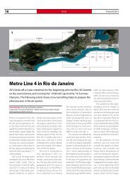
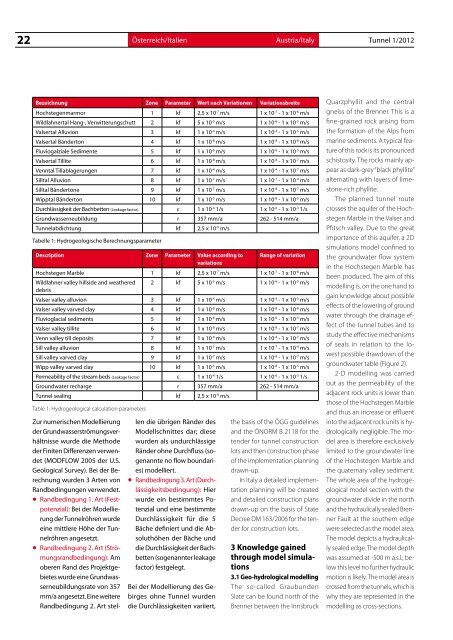
22 Österreich/Italien<br />
Austria/Italy <strong>Tunnel</strong> 1/2012<br />
Bezeichnung Zone Parameter Wert nach Variationen Variationsbreite<br />
Hochstegenmarmor 1 kf 2,5 x 10 -7 m/s 1 x 10 -7 - 1 x 10 -6 m/s<br />
Wildlahnertal Hang-, Verwitterungschutt 2 kf 5 x 10 -5 m/s 1 x 10 -6 - 1 x 10 -5 m/s<br />
Valsertal Alluvion 3 kf 1 x 10 -4 m/s 1 x 10 -4 - 1 x 10 -5 m/s<br />
Valsertal Bänderton 4 kf 1 x 10 -8 m/s 1 x 10 -8 - 1 x 10 -6 m/s<br />
Fluviogalziale Sed<strong>im</strong>ente 5 kf 1 x 10 -6 m/s 1 x 10 -6 - 1 x 10 -5 m/s<br />
Valsertal Tillite 6 kf 1 x 10 -8 m/s 1 x 10 -8 - 1 x 10 -7 m/s<br />
Venntal Tillablagerungen 7 kf 1 x 10 -4 m/s 1 x 10 -4 - 1 x 10 -7 m/s<br />
Silltal Alluvion 8 kf 1 x 10 -7 m/s 1 x 10 -7 - 1 x 10 -4 m/s<br />
Silltal Bändertone 9 kf 1 x 10 -7 m/s 1 x 10 -8 - 1 x 10 -7 m/s<br />
Wipptal Bänderton 10 kf 1 x 10 -5 m/s 1 x 10 -8 - 1 x 10 -5 m/s<br />
Durchlässigkeit der Bachbetten (Leakage factor) c 1 x 10 -4 1/s 1 x 10 -6 - 1 x 10 -3 1/s<br />
Grundwasserneubildung r 357 mm/a 262 - 514 mm/a<br />
<strong>Tunnel</strong>abdichtung kf 2,5 x 10 -9 m/s<br />
Tabelle 1: Hydrogeologische Berechnungsparameter<br />
Description Zone Parameter Value according to<br />
variations<br />
Zur numerischen Modellierung<br />
der Grundwasserströmungsverhältnisse<br />
wurde die Methode<br />
der Finiten Differenzen verwendet<br />
(MODFLOW 2005 der U.S.<br />
Geological Survey). Bei der Berechnung<br />
wurden 3 Arten von<br />
Randbedingungen verwendet.<br />
• Randbedingung 1. Art (Festpotenzial):<br />
Bei der Modellierung<br />
der <strong>Tunnel</strong>röhren wurde<br />
eine mittlere Höhe der <strong>Tunnel</strong>röhren<br />
angesetzt.<br />
• Randbedingung 2. Art (Strömungsrandbedingung):<br />
Am<br />
oberen Rand des Projektgebietes<br />
wurde eine Grundwasserneubildungsrate<br />
von 357<br />
mm/a angesetzt. Eine weitere<br />
Randbedingung 2. Art stel-<br />
len die übrigen Ränder des<br />
Modellschnittes dar; diese<br />
wurden als undurchlässige<br />
Ränder ohne Durchfluss (sogenannte<br />
no flow boundaries)<br />
modelliert.<br />
• Randbedingung 3. Art (Durchlässigkeitsbedingung):<br />
Hier<br />
wurde ein best<strong>im</strong>mtes Potenzial<br />
und eine best<strong>im</strong>mte<br />
Durchlässigkeit für die 5<br />
Bäche definiert und die Absoluthöhen<br />
der Bäche und<br />
die Durchlässigkeit der Bachbetten<br />
(sogenannter leakage<br />
factor) festgelegt.<br />
Bei der Modellierung des Gebirges<br />
ohne <strong>Tunnel</strong> wurden<br />
die Durchlässigkeiten variiert,<br />
Range of variation<br />
Hochstegen Marble 1 kf 2,5 x 10 -7 m/s 1 x 10 -7 - 1 x 10 -6 m/s<br />
Wildlahner valley hillside and weathered<br />
debris<br />
2 kf 5 x 10 -5 m/s 1 x 10 -6 - 1 x 10 -5 m/s<br />
Valser valley alluvion 3 kf 1 x 10 -4 m/s 1 x 10 -4 - 1 x 10 -5 m/s<br />
Valser valley varved clay 4 kf 1 x 10 -8 m/s 1 x 10 -8 - 1 x 10 -6 m/s<br />
Fluvioglacial sed<strong>im</strong>ents 5 kf 1 x 10 -6 m/s 1 x 10 -6 - 1 x 10 -5 m/s<br />
Valser valley tillite 6 kf 1 x 10 -8 m/s 1 x 10 -8 - 1 x 10 -7 m/s<br />
Venn valley till deposits 7 kf 1 x 10 -4 m/s 1 x 10 -4 - 1 x 10 -7 m/s<br />
Sill valley alluvion 8 kf 1 x 10 -7 m/s 1 x 10 -7 - 1 x 10 -4 m/s<br />
Sill valley varved clay 9 kf 1 x 10 -7 m/s 1 x 10 -8 - 1 x 10 -7 m/s<br />
Wipp valley varved clay 10 kf 1 x 10 -5 m/s 1 x 10 -8 - 1 x 10 -5 m/s<br />
Permeability of the stream beds (Leakage factor) c 1 x 10 -4 1/s 1 x 10 -6 - 1 x 10 -3 1/s<br />
Groundwater recharge r 357 mm/a 262 - 514 mm/a<br />
<strong>Tunnel</strong> sealing kf 2,5 x 10 -9 m/s<br />
Table 1: Hydrogeological calculation parameters<br />
the basis of the ÖGG guidelines<br />
and the ÖNORM B 2118 for the<br />
tender for tunnel construction<br />
lots and then construction phase<br />
of the <strong>im</strong>plementation planning<br />
drawn-up.<br />
In Italy a detailed <strong>im</strong>plementation<br />
planning will be created<br />
and detailed construction plans<br />
drawn-up on the basis of State<br />
Decree DM 163/2006 for the tender<br />
for construction lots.<br />
3 Knowledge gained<br />
through model s<strong>im</strong>ulations<br />
3.1 Geo-hydrological modelling<br />
The so-called Graubunden<br />
Slate can be found north of the<br />
<strong>Brenner</strong> between the Innsbruck<br />
Quarzphyllit and the central<br />
gneiss of the <strong>Brenner</strong>. This is a<br />
fine-grained rock arising from<br />
the formation of the Alps from<br />
marine sed<strong>im</strong>ents. A typical feature<br />
of this rock is its pronounced<br />
schistosity. The rocks mainly appear<br />
as dark-grey “black phyllite”<br />
alternating with layers of l<strong>im</strong>estone-rich<br />
phyllite.<br />
The planned tunnel route<br />
crosses the aquifer of the Hochstegen<br />
Marble in the Valser and<br />
Pfitsch valley. Due to the great<br />
<strong>im</strong>portance of this aquifer, a 2D<br />
s<strong>im</strong>ulations model confined to<br />
the groundwater flow system<br />
in the Hochstegen Marble has<br />
been produced. The a<strong>im</strong> of this<br />
modelling is, on the one hand to<br />
gain knowledge about possible<br />
effects of the lowering of ground<br />
water through the drainage effect<br />
of the tunnel tubes and to<br />
study the effective mechanisms<br />
of seals in relation to the lowest<br />
possible drawdown of the<br />
groundwater table (Figure 2).<br />
2-D modelling was carried<br />
out as the permeability of the<br />
adjacent rock units is lower than<br />
those of the Hochstegen Marble<br />
and thus an increase or effluent<br />
into the adjacent rock units is hydrologically<br />
negligible. The model<br />
area is therefore exclusively<br />
l<strong>im</strong>ited to the groundwater line<br />
of the Hochstegen Marble and<br />
the quaternary valley sed<strong>im</strong>ent.<br />
The whole area of the hydrogeological<br />
model section with the<br />
groundwater divide in the north<br />
and the hydraulically sealed <strong>Brenner</strong><br />
Fault at the southern edge<br />
were selected as the model area.<br />
The model depicts a hydraulically<br />
sealed edge. The model depth<br />
was assumed at -500 m a.s.l.; below<br />
this level no further hydraulic<br />
motion is likely. The model area is<br />
crossed from the tunnels, which is<br />
why they are represented in the<br />
modelling as cross-sections.