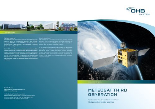
Meteosat third Generation - OHB AG
Meteosat third Generation - OHB AG
Meteosat third Generation - OHB AG
- Keine Tags gefunden...

Erfolgreiche ePaper selbst erstellen
Machen Sie aus Ihren PDF Publikationen ein blätterbares Flipbook mit unserer einzigartigen Google optimierten e-Paper Software.
MTG-ProgrammMTG ProgrammeMTG-Nutzlasten und -DiensteMTG Payloads and ServicesDas Programm „<strong>Meteosat</strong> Third <strong>Generation</strong>“ (= MTG – <strong>Meteosat</strong>der dritten <strong>Generation</strong>) umfasst die Entwicklung der nächsten<strong>Generation</strong> von europäischen geostationären Wettersatelliten fürnumerische Wetterprognosen und kurzfristige Vorhersagen. DasMTG-System wird von der europäischen Organisation EUMETSAT(Exploitation of Meteorological Satellites) betrieben und sowohldie europäischen nationalen Wetterdienste als auch internationaleNutzer und die Wissenschaft mit verbesserten und leistungsfähigerenBildaufnahme- und neuen Infrarotsondierungsverfahrenfür meteorologische und Klimaanwendungen versorgen.Das MTG-Programm wird als gemeinsames Projekt zwischenEUMESAT und der European Space Agency (ESA) umgesetzt. DieESA ist für die Entwicklung des MTG-Weltraumsegments zuständig,während EUMESAT die Verantwortung für die Entwicklungdes MTG-Bodensegments und die Beschaffung der Startdiensteträgt. Die <strong>OHB</strong> System <strong>AG</strong> realisiert ihren Beitrag im Rahmen desMTG-Programmes im Unterauftrag der Thales Alenia Space France.Das MTG-System wird kontinuierlich hochauflösende Beobachtungs-und geophysikalische Parameter des Erdsystems liefern,die sich aus direkten Messungen ihrer emittierten und reflektiertenStrahlung unter Nutzung von satellitenbasierten Sensorenaus dem geostationären Orbit ergeben. Dank technologischerFortschritte wird MTG im Vergleich zum aktuellen MSG-Systemleistungsfähiger sein und mit der verbesserten Imager-Missionund der Einführung der neuen Sounder- und Lightning-Missionenaus dem geostationären Orbit die bestehenden Dienste bedeutendoptimieren. Insgesamt wird das MTG-System die folgenden Missionen,Dienste und damit verbundenen Nutzlasten unterstützen:The <strong>Meteosat</strong> Third <strong>Generation</strong> (MTG) programme aims at developingthe next generation of the European geostationary <strong>Meteosat</strong>satellite system for numerical weather prediction and nowcasting.The MTG system will be operated by the European Organisationfor the Exploitation of Meteorological Satellites(EUMETSAT) and will provide Europe’s national meteorologicalservices as well as international users and science communitywith improved imaging and new infrared sounding capabilities forboth meteorological and climate applications.The MTG programme is established as a common undertakingbetween EUMETSAT and the European Space Agency (ESA). ESAis responsible for the development of the MTG space segment.EUMETSAT is responsible for the development of the MTG groundsegment and the procurement of recurring satellites and thelaunch services. <strong>OHB</strong> System is contributing to the MTG programmein the frame of a subcontract to Thales Alenia SpaceFrance.The objective of the MTG system is to provide continuous highresolutionobservations and geophysical parameters of the Earthsystem derived from direct measurements of the radiation whichit emits and reflects using satellite-based sensors from a geostationaryorbit. Thanks to advances in technology, MTG will alsoprovide an enhanced service compared to the current MSG system,contributing significant improvements to the existing servicewith an improved imagery mission and introducing new soundingand lightning missions from a geostationary orbit. All in all, theMTG system will be supporting the following missions, servicesand associated payloads:• Flexible Combined Imager (FCI)Die FCI-Mission ermöglicht es, entweder die gesamte Erd scheibein 16 Kanälen im 10-Minuten-Takt und mit einer Auflösungim Bereich von 1 bis 2 km zu scannen oder sie kann ein Viertelder Erdscheibe in vier Kanälen mit einer Wiederholungsratevon 2,5 Minuten mit einer doppelt so hohen Auflösung erfassen.• InfraRed Sounding (IRS)Diese Mission deckt die gesamte Erdscheibe vollständig abund stellt hyperspektrale Sondierungsdaten in zwei Bändernzur Verfügung: einem langwelligen Infrarotband (LWIR:700 – 1210 cm-1) und einem mittelwelligen Infrarotband(MWIR: 1600 – 2175 cm-1) mit einer Auflösung von ca. 4 km.• Lightning Imagery (LI)Mit einer Auflösung von etwa 10 km erkennt und lokalisiertdie LI-Mission auf fast der gesamten Erdscheibe kontinuierlichBlitzentladungen, die sich in den Wolken bzw. zwischenWolke und Boden ereignen.• Die Ultraviolet, Visible & Near-infrared (UVN)Die Sondierungs-Mission deckt Europa im Stundentakt mit Messungenin drei Spektralbändern (UV: 290 – 400 nm; VIS: 400 – 500nm, NIR: 755 – 775 nm) mit einer Auflösung von ca. 10 km ab. DieUVN-Mission wird mit der GMES Sentinel-4/UVN-Nutzlastimplementiert.• Der Search and Rescue (SAR)-Relais-DienstBietet den geostationären Such- und Rettungsdienst (GEOSAR)im Rahmen des internationalen Systems Cospas-Sarsat anund ist darauf ausgerichtet, einen Notfallalarm und Standortangabenan die entsprechenden Rettungsleitstellen für inNot befindliche Nutzer in der Schifffahrt, Luftfahrt sowie anLand zu übermitteln.• Flexible combined imager (FCI) missionAllowing scanning of the full disc in 16 channels every 10 minuteswith a resolution in a range of 1–2 km, or a quarter of the earthdisc in 4 channels every 2.5 minutes with a resolution twice ashigh.• Infrared sounding (IRS) missionCovering the full disc, providing hyperspectral soundinginformation in two bands, a long wave infrared(LWIR: 700 – 1210 cm-1) and mid wave infrared (MWIR:1600 – 2175 cm-1) band with a resolution of around 4 km.• Lightning imagery (LI) missionDetecting continuously almost the full earth disc, lightningdischarges occurring in clouds or between cloud and groundwith a resolution around 10 km.• Ultraviolet, visible & near-infrared (UVN) sounding missionCovering Europe every hour taking measurements in threespectral bands (UV: 290 – 400 nm; VIS: 400 – 500 nm, NIR:755 – 775 nm) with a resolution of around 10 km. The UVN missionwill be implemented with the GMES Sentinel-4/UVN payload.• Search and rescue (SAR) relay serviceProviding the geostationary search and rescue (GEOSAR) serviceas part of the Cospas-Sarsat international system whose aimis to provide distress alert and location information for rescueauthorities for maritime, aviation and land users in distress.• Data collection system (DCS) missionWhich involves the collection and transmission of observationsand data from surface, buoy, ship, balloon or airborne datacollection platforms (DCP).• Die Data Collection System (DCS)-MissionUmfasst das Sammeln und die Übermittlung von in so genanntenData Collection Platforms (DCP) am Boden, auf Bojen,Schiffen oder in Ballons erfassten Beobachtungen und Daten.
DAS MTG-RAUMSEGMENTMTG SPACE SEGMENTMTG – INDUSTRIELLES KERNTEAMMTG INDUSTRIAL CORE TEAMDas MTG-Raumsegment besteht aus sechs Satelliten mit zweiunterschiedlichen Nutzlastpaketen. Das System setzt sich ausvier MTG-I-Satelliten für die Abbildungsanwendungen sowie zweiMTG S-Satelliten für die Sounding-Anwendungen zusammen.Der MTG-I-Satellit trägt die Nutzlasten FCI, LI, SAR und DCS. DerMTG-S-Satellit trägt die Nutzlasten IRS und UVN.Sowohl MTG-I als auch MTG-S sind auf einer gemeinsamen Drei-Achsen-stabilisierten Plattform auf Basis der SGEO-Plattformvon <strong>OHB</strong> untergebracht.Das Entwicklungsprogramm für das MTG-Raumsegment befindetsich seit November 2010 in der Implementierungsphase. Dererste MTG-I-Satellit soll 2017 gestartet werden, der Start für denersten MTG-S-Satelliten für 2019 geplant ist.The MTG space segment consists of six satellites carrying twodifferent payload suites. The system is composed of four MTG-Isatellites dedicated to the imaging applications and two MTG-Ssatellites dedicated to sounding applications. The MTG-I satelliteembarks the FCI, LI, SAR and DCS payloads. The MTG-S satelliteembarks the IRS and UVN payloads.Both MTG-I and MTG-S are based on a common three-axis stabilisedplatform on the basis of <strong>OHB</strong>’s SGEO platform.The MTG space segment development programme entered theimplementation phase in November 2010. The launch of the firstMTG-I satellite is planned for 2017, the first MTG-S satellite isscheduled for launch in 2019.Die <strong>OHB</strong> System <strong>AG</strong> ist Teil des industriellen Kernteams für dasProjekt MTG, das von der ESA für die Implementierungsphasedes Programms ausgewählt wurde. Zum industriellen MTG-Kernteam gehören:• Thales Alenia Space France,• als Hauptauftragnehmer für das MTG-Weltraumsegment• Hauptauftragnehmer für die MTG-I-Missionund die MTG-I-Satelliten• Hauptauftragnehmer für die FCI-Nutzlast• <strong>OHB</strong> System <strong>AG</strong>,• Hauptauftragnehmer für die MTG-S-Missionund die MTG-S-Satelliten• Hauptauftragnehmer für die gemeinsame MTG-Plattform• Kayser-Threde GmbH,• als Hauptauftragnehmer für die IRS-NutzlastAls Hauptauftragnehmer für die MTG-S-Mission und den Satellitenist die <strong>OHB</strong> System <strong>AG</strong> für alle Missionsaspekte sämtlicheAufgaben im Zusammenhang mit der Mission sowie für Satelliten-Design,-entwicklung, -beschaffung, MAIT und -lieferungverantwortlich. Die <strong>OHB</strong> System <strong>AG</strong> trägt die Verantwortung fürdie Entwicklung der MTG-S-Plattformen sowie für die Beschaffungdes IRS-Instruments.Als Hauptauftragnehmer für die gemeinsame MTG-Plattform istdie <strong>OHB</strong> System <strong>AG</strong> verantwortlich für das Design, die Entwicklung,Beschaffung, MAIT und Lieferung aller sechs MTG-Plattformen,von denen vier zur Integration der MTG-I-Satelliten an ThalesAlenia Space France geliefert werden, während die anderenzwei für die Integration der MTG-S-Satelliten bei der <strong>OHB</strong> System<strong>AG</strong> genutzt werden.<strong>OHB</strong> System <strong>AG</strong> is part of the MTG industrial core team, which hasbeen selected by ESA for the implementation phase of the programme.The MTG industrial core team comprises:• Thales Alenia Space France,• MTG space segment prime contractor• MTG-I mission and MTG-I satellite prime contractor• FCI payload prime contractor• <strong>OHB</strong> System <strong>AG</strong>,• MTG-S mission and MTG-S satellite prime contractor• MTG common platform prime contractor• Kayser-Threde GmbH,• as IRS payload prime contractorAs the MTG-S mission and satellite prime contractor, <strong>OHB</strong> System<strong>AG</strong> is responsible for the overall MTG-S mission, which includesall mission and performance-related tasks as well as satellitedesign, development, procurement, MAIT and delivery. <strong>OHB</strong>System <strong>AG</strong> is in charge of the development of the MTG-S platformsand the procurement of the IRS instrument.As the MTG common platform prime contractor, <strong>OHB</strong> System <strong>AG</strong>is responsible for the design, development, procurement, MAITand delivery of all six MTG platforms, four of which are to be deliveredto Thales Alenia Space France for the integration of theMTG-I satellites, while the other two are to be used for the integrationof the MTG-S satellites at <strong>OHB</strong> System <strong>AG</strong>.Industrielles Kernteam / Industrial Core TeamMTG-I Mission PrimeMTG-S Mission PrimePlatformPlatformFCIIRSUVN (GMES)
MTG Common PlatformMTG Common PlatformMTG-S Infrarot-Nutzlast (IRS)MTG-S Infrared Payload (IRS)Die MTG Common Platform wird auf der Grundlage der geostationärenPlattform von <strong>OHB</strong> System im Rahmen des SGEO/H<strong>AG</strong>1-Projekts als Teil des ARTES 11-Programms der ESA entwickelt.Es handelt sich um eine Drei-Achsen-stabilisierte Plattform fürgeostationäre Anwendungen, die für eine Satelliten-Gesamtstartmassein der Größenordnung von 3.200 kg ausgelegt ist. Fürdie MTG-Mission wird die Plattform angepasst und erweitert,damit sie den hohen Anforderungen in Bezug auf die Ausrichtungsstabilitäteines Erdbeobachtungs¬satelliten erfüllt sowieder von EUMETSAT betriebenen Kommunikationsinfrastrukturentspricht.Die von der OHG-System <strong>AG</strong> gelieferte MTG Common Platformwird gemeinsam von den MTG-I- und MTG-S-Satelliten genutzt.Damit liefert <strong>OHB</strong> System sechs Satellitenplattformen.The MTG common platform is based on the <strong>OHB</strong> System’s geostationaryplatform, which is currently under development as part ofthe SGEO/H<strong>AG</strong>1 project under ESA’s ARTES 11 programme. It is athree-axis stabilised platform for geostationary satellite applicationscompatible with a total satellite launch mass in the order of3200 kg. The platform is being adapted and upgraded for the MTGmission to fulfil the high pointing stability requirements of anEarth observation application as well as to comply with the communicationinfrastructure operated by EUMETSAT.The MTG common platform provided by <strong>OHB</strong> System <strong>AG</strong> is commonlyused by both MTG-I and MTG-S satellites. <strong>OHB</strong> System willdeliver 6 satellite platforms.Kayser-Threde GmbH ist der Hauptauftragnehmer für das IRS(Infra-Red Sounder)-Instrument und trägt damit die Verantwortungfür das Design, die Entwicklung, die Beschaffung, AIT sowiedie Lieferung von zwei Flugmodellen.Das IRS-Instrument ist so ausgelegt, dass es mit hoher radiometrischerGenauigkeit die von Gasen in die Atmosphäre emittiertenSignale erkennt; dies geschieht mit einer anspruchsvollen spektralenAuflösung für die Geschwindigkeitsbestimmung, so dassWindprofile in verschiedenen Höhen über dem Boden mit hoherräumlicher und zeitlicher Auflösung bestimmt werden können.Das Instrument ist ein Fourier-Transformations-Spektrometer,das in der Lage ist, aus der geostationären Umlaufbahn dengesamten Erdkreis mit einer räumlichen Auflösung von 4 km x 4km innerhalb einer Stunde zu scannen. Diese Auflösung kann mitHilfe eines hoch auflösenden Teleskops erzielt werden, das imInfrarot-Spektralbereich mit einer Anordnung der Scannerspiegelarbeitet, durch die eine stufenweise Betrachtung („Step andStare“) der Sichtlinie ermöglicht wird. Radiometrische, spektraleund geometrische Anforderungen werden sowohl unter nominalenals auch unter eingeschränkten Betriebsbedingungen erfüllt.Neben der Rolle in Bezug auf das IRS-Instrument übernimmt dieKayser-Threde GmbH im Rahmen des MTG-Programms auchnoch die Verantwortung für das Design, die Entwicklung, Beschaffung,AIT und Lieferung von vier Flugmodellen des Teleskopsystemsdes Flexible Combined Imager (FCI) gemäß eines Untervertragsmit Thales Alenia Space France.Kayser-Threde GmbH is the prime contractor for the IRS (infraredsounder) instrument and responsible for the design, development,procurement, AIT and the deliveryof two flight models.The IRS instrument is designed to detect with high radiometricaccuracy the signals emitted from gases in the atmosphere with ademanding spectral resolution for velocity determination in orderto determine the wind profiles at various heights above groundtogether with a high spatial and temporal resolution.The instrument is an imaging Fourier transform spectrometer,which is able to scan the full earth circle within 1 hour with a spatialon-ground resolution of 4km x 4km from a geostationaryorbit. This resolution can be achieved by means of a high-resolutiontelescope operating in the IR spectral range with a scan mirrorassembly allowing a step and stare of the line of sight. Radiometric,spectral and geometric requirements are met both innominal and restricted operations conditions.In the MTG programme, Kayser-Threde GmbH in addition to itsrole on the IRS instrument is also responsible for the design,development, procurement, AIT and delivery of 4 flight models forthe telescope assembly of the flexible combined imager (FCI) in asubcontract to Thales Alenia Space France.Launch Locking for Cover+Z-SatAperture CoverSpring-loaded MechanismSolar BaffleMichelson InterferometerBSCC Optics+X-Sat-YCalibration Unit BaffleInterferometer BenchBack Telescope+Y-Sat-XFront Telescope Mirror 3Inner Baffle Prism aroundScan Mirror AssemblyBaffle Support Ti6AI4VOptical BenchFront Telescope Mirror 1Inner Baffle CylinderSupport StructureBipods