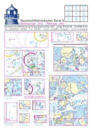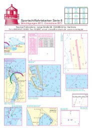
NV. Sportschiffahrtskarten - NV-Verlag
NV. Sportschiffahrtskarten - NV-Verlag
NV. Sportschiffahrtskarten - NV-Verlag

Erfolgreiche ePaper selbst erstellen
Machen Sie aus Ihren PDF Publikationen ein blätterbares Flipbook mit unserer einzigartigen Google optimierten e-Paper Software.
<strong>NV</strong>. <strong>Sportschiffahrtskarten</strong><br />
Cruising Guide<br />
Bücher<br />
28 29<br />
Service: dinghy dock and<br />
ferry to Road Town.<br />
mooring for 20 $ a night at<br />
Maschineel Bay<br />
VHF: none<br />
Fuel: none<br />
Cooper Island<br />
Virgin Islands<br />
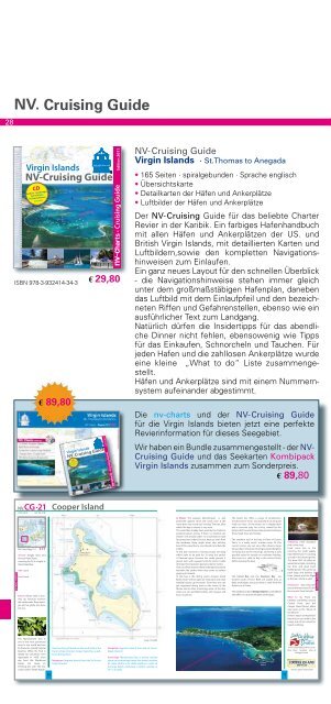
<strong>NV</strong>-Cruising Guide<br />
CD<br />
Harbors · Anchorages<br />
Aerial Views<br />
PC Nav Software<br />
included<br />
ISBN 978-3-932414-34-3<br />
<strong>NV</strong>.CG ·21<br />
18°23,0´N 64° 30,7´W<br />
<strong>NV</strong>. Chart Reg.12.1 · C 17<br />
Advice: Please take a mooring<br />
up, because anchors<br />
the underwater flora damages<br />
and so gladly one does<br />
not see.<br />
€ 89,80<br />
Virgin Islands<br />
Cooper Island<br />
€ 29,80<br />
<strong>NV</strong>-Cruising Guide<br />
CD<br />
Harbors · Anchorages<br />
Aerial Views<br />
PC Nav Software<br />
included<br />
Edition 2011<br />
nv- charts · Cruising Guide<br />
Edition 2011<br />
nv- charts · Cruising Guide<br />
<strong>NV</strong>-Cruising Guide<br />
Virgin Islands · St.Thomas to Anegada<br />
• 165 Seiten · spiralgebunden · Sprache englisch<br />
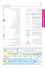
• Übersichtskarte<br />
• Detailkarten der Häfen und Ankerplätze<br />
• Luftbilder der Häfen und Ankerplätze<br />
Der <strong>NV</strong>-Cruising Guide für das beliebte Charter<br />
Revier in der Karibik. Ein farbiges Hafenhandbuch<br />
mit allen Häfen und Ankerplätzen der US. und<br />
British Virgin Islands, mit detaillierten Karten und<br />
Luftbildern,sowie den kompletten Navigationshinweisen<br />
zum Einlaufen.<br />
Ein ganz neues Layout für den schnellen Überblick<br />
- die Navigationshinweise stehen immer gleich<br />
unter dem großmaßstäbigen Hafenplan, daneben<br />
das Luftbild mit dem Einlaufpfeil und den bezeichneten<br />
Riffen und Gefahrenstellen, ebenso wie ein<br />
ausführlicher Text zum Landgang.<br />
Natürlich dürfen die Insidertipps für das abendliche<br />
Dinner nicht fehlen, ebensowenig wie Tipps<br />
für das Einkaufen, Schnorcheln und Tauchen. Für<br />
jeden Hafen und die zahllosen Ankerplätze wurde<br />
eine kleine „What to do“ Liste zusammengestellt.<br />
Häfen und Ankerplätze sind mit einem Nummernsystem<br />
aufeinander abgestimmt.<br />
Die nv-charts und der <strong>NV</strong>-Cruising Guide<br />
für die Virgin Islands bieten jetzt eine perfekte<br />
Revierinformation für dieses Seegebiet.<br />
Wir haben ein Bundle zusammengestellt - der <strong>NV</strong>-<br />
Cruising Guide und das Seekarten Kombipack<br />
Virgin Islands zusammen zum Sonderpreis.<br />
€ 89,80<br />
A Shore: The popular Manchioneel is well<br />
protected against wind and swell, even if the<br />
name does not sound very inviting. The tree, after<br />
which the bay is named, is very toxic.<br />
The wood has already been used by the Caribs to<br />
produce poison arrows. If there is a tropical rain<br />
shower one should under no circumstances look<br />
for protection under this tree, because even from<br />
the raindrops there might occur skin etching.<br />
Even if this wood burns, one should not inhale the<br />
smoke.<br />
In the bay numerous mooring buoys are lying<br />
which have to be paid for. To drop the anchor<br />
is frowned upon, because the sandy ground is<br />
grown over with seaweed and the anchor cable<br />
destroys this important pasture area for turtles.<br />
One can often observe these endangered animals<br />
between the yachts when they come to surface<br />
gasping for breath.<br />
In this bay is the diving resort „Cooper Island<br />
Beach Club“ with an open air restaurant and small<br />
holiday houses up the beach. From here one can<br />
get organized diving tours to the wreck of the<br />
Rhone and to other interesting areas. In the dive<br />
shop one can get filled bottles with oxygen and<br />
buy a souvenirs.<br />
The beach bar offers a range of sundowners,<br />
snacks and live music. Occasionally it can be quite<br />
lively out here. At the beach are a dinghy-dock<br />
and a concrete jetty for a ferry, owned by the<br />
hotel, which several times a day operates between<br />
there, Road Town and Tortola.<br />
The southern end of the bay, in front of Cistern<br />
Point, is a really worth snorkel route. At this<br />
current corner one can very often observe large<br />
barracudas. In this area mooring buoys for dinghies<br />
are lying. Due to the moorings, anchoring is only<br />
possible quite far outside on moderate holding.<br />
Also here it is valid to dig in the anchor firmly<br />
before leaving the boat.<br />
The Carver Bay and the Haulover Bay are<br />
located south of here. Both are usable only as<br />
daily anchorages, because there is swell from the<br />
Atlantic at all times.<br />
The neighbour island Ginger Island is uninhabited<br />
and offers no recommendable anchorages.<br />
Shopping: small Boutique<br />
and a dive shop.<br />
Food none, but in the<br />
morning the small supply<br />
boat “Deliverance” is coming<br />
around in the mooring field.<br />
This boat (VHF 16) offers its<br />
wares about dusk, including<br />
ice, fruit, and great fresh<br />
baked goods. Also, picks up<br />
trash bags and delivers to<br />
Peter islands and the Bight<br />
at Norman Island as well.<br />
Restaurant: big restaurant<br />
area at the resort also for the<br />
ferry tourist from Tortolla.<br />
What to do: There are<br />
exellent snorkeling around<br />
Cistern Point and the<br />
Cooper Island Resort offers<br />
dive tours to the “Wrack of<br />
the Rhone”.<br />
Perfect beach at Machineel<br />
Bay and you can walk to the<br />
ocean side of the island for<br />
beach combing.<br />
The Manchioneel tree is<br />
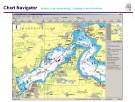
Scale 1:16,000<br />
one of the most poisonous<br />
trees in the world and can<br />
be found on coastal tropical<br />
beaches. While the fruit is<br />
deadly [as Columbus’ men<br />
One the string of Islands on the south side of the<br />
Francis Drake Channel, Cooper Island has a wellknow<br />
diving resort.<br />
Navigation: Approch directly from the Sir Francis<br />
Drake Channel.<br />
www.sailcaribbeandivers.com<br />
Dive shop location also at<br />
Hodges Creek.<br />
reportedly in 1493], even<br />
Anchorage: Manchioneel Bay is almost entirely<br />
sap from the Machineel Navigation: Approch directly from the Sir Francis taken up by moorings buoys that make i possible<br />
leaves can cause an Drake Channel.<br />
for many yachts to lie clode together, in spite of<br />
irritating skin rash. The tree<br />
the large depth. Anchorage is farther outside on<br />
is also called “Death Apple”.<br />
15 m of water.<br />
www.cooper-island.com<br />
76 77<br />
moorings<br />
Tauch<br />
Resort<br />
dinghy<br />
moorings<br />
Cistern<br />
Point<br />
Cooper Island<br />
ISBN 978-3-926376-12-1 ISBN 978-3-926376-16-9 ISBN 978-3-926376-15-2<br />
Segelhandbuch<br />
für den<br />
Atlantl. Ozean<br />
• 556 Seiten<br />
• Tabellen und Karten<br />
€ 54,-<br />
Segelhandbuch<br />
für den<br />
Indischen Ozean<br />
• 812 Seiten<br />
• Tabellen und Karten<br />
€ 54,-<br />
Segelhandbuch<br />
für den<br />
Stillen Ozean<br />
• 933 Seiten<br />
• Tabellen und Karten<br />
€ 68,-<br />
Die Klassiker der Segelhandbücher. Raritäten – die seit Jahrzehnten<br />
vergriffen waren – jetzt als ungekürzte Reprints der letzten Ausgaben<br />
wieder aufgelegt. Sie basieren auf den Beobachtungen<br />
während der Segelschiffsreisen und kombinieren die authentischen<br />
Reiseberichte der Kapitäne mit wissenschaftlichen Daten über<br />
Windsysteme, Strömungen und Ozeane sowie zahlreiche Karten<br />
und Tabellen.<br />
Der Bildband enthält alle Luftbilder für<br />
die Häfen & Ankerplätze der Virgin<br />
Islands und der Leeward Islands bis<br />
Antigua, mit Informationen zum<br />
Landgang und zur Ansteuerung.<br />
Texte in deutsch.<br />
ISBN 3-932414-17-6<br />
jetzt € 19,80<br />
<strong>NV</strong>. Schiffstagebuch<br />
• 143 Seiten · Einband blau oder grau<br />
• Lesefaden<br />
Mit den vorgeschriebenen Seitenzahlen<br />
und klarer Aufteilung für<br />
Tagesberichte, Landgang, Wetterprognose,<br />
Besatzungs-, Wartungund<br />
Winterarbeitslisten sowie<br />
einem kleinen Gästebuch.<br />
ISBN 978-3-926376-14-5 € 12,80<br />
®<br />
Die 3 Standardwerke<br />
der Segelschifffahrt<br />
waren<br />
und sind eine<br />
wertvolle Hilfe,<br />
um konstante,<br />
schnelle und sichere<br />
Seereisen zu<br />
fahren, damals<br />
für die Großsegler<br />
und heute<br />
für die Hochseesegler.<br />
im Bundle<br />
€ 128,-