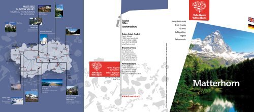
Antey-Saint-André Breuil-Cervinia Chamois La Magdeleine ... - Enit
Antey-Saint-André Breuil-Cervinia Chamois La Magdeleine ... - Enit
Antey-Saint-André Breuil-Cervinia Chamois La Magdeleine ... - Enit

Sie wollen auch ein ePaper? Erhöhen Sie die Reichweite Ihrer Titel.
YUMPU macht aus Druck-PDFs automatisch weboptimierte ePaper, die Google liebt.
Tunnel du<br />
Mont-Blanc<br />
M O N T E B I A N C O<br />
Col du<br />
Petit-<strong>Saint</strong>-Bernard<br />
Traverse of Mont<br />
Blanc<br />
Überquerung des<br />
Mont Blanc<br />
Mont Blanc<br />
Pré-<strong>Saint</strong>-Didier<br />
<strong>La</strong> Thuile<br />
Spas<br />
Therme<br />
Valgrisenche<br />
Aosta roman and<br />
medieval town<br />
Aosta römische und<br />
mittelalterliche Stadt<br />
Col / Tunnel du<br />
Grand-<strong>Saint</strong>-Bernard<br />
St-Rhémy-en-Bosses étroubles<br />
Courmayeur<br />
Valsavarenche<br />
Rhêmes-Notre-Dame<br />
PARCO NAZIONALE<br />
G R A P R A D I S O<br />
N A<br />
AOSTA<br />
Sarre<br />
GRAN PARADISO<br />
Gran Paradiso<br />
Sant’Orso fair<br />
Sankt Orso-Messe<br />
Astronomic observatory<br />
Astronomische Observatorium<br />
Valpelline<br />
Cogne<br />
Pila<br />
St-Barthélemy<br />
Fénis<br />
PARCO DEL MONT AVIC<br />
Champorcher<br />
C E R V I N O<br />
<strong>Breuil</strong>-<strong>Cervinia</strong><br />
Valtournenche<br />
Châtillon<br />
St-Vincent<br />
Issogne<br />
360° view over the whole chain<br />
of the Alps<br />
360° Aussicht auf die gesamte<br />
Alpenkette<br />
Matterhorn<br />
Ayas<br />
Verrès<br />
Brusson<br />
M O N T E R O S A<br />
Gressoney<br />
<strong>La</strong> Trinité<br />
Gressoney-St-Jean<br />
Bard<br />
Monte Rosa<br />
Pont-St-Martin<br />
Torino<br />
Milano<br />
Genova<br />
Fénis (1), Issogne (2), Verrès (3),<br />
Sarre (4) castles and<br />
Bard Fortress (5)<br />
Schlösser Fénis (1), Issogne (2)<br />
Verrès (3) und Bard Festung (5)<br />
Office Régional<br />
du Tourisme<br />
Ufficio Regionale<br />
del Turismo<br />
V.le Federico Chabod, 15<br />
11100 Aosta<br />
Tourist<br />
Office<br />
Tourismusbüro<br />
<strong>Antey</strong>-<strong>Saint</strong>-<strong>André</strong><br />
P.zza A. Rolando<br />
11020 <strong>Antey</strong>-<strong>Saint</strong>-<strong>André</strong><br />
Tel (+39) 0166 548266<br />
Fax (+39) 0166 548388<br />
antey@turismo.vda.it<br />
<strong>Breuil</strong>-<strong>Cervinia</strong><br />
Via Guido Rey, 17<br />
Loc. <strong>Breuil</strong>-<strong>Cervinia</strong><br />
11021 Valtournenche<br />
Tel (+39) 0166 949136<br />
Fax (+39) 0166 949731<br />
cervinia@turismo.vda.it<br />
Valtournenche<br />
Via Roma, 80<br />
11028 Valtournenche<br />
Tel (+39) 0166 92029<br />
Fax (+39) 0166 92430<br />
valtournenche@turismo.vda.it<br />
www.lovevda.it<br />
fotografie: archivio assessorato turismo, sport, commercio e trasporti • consorzi operatori turistici • archivi comunali • f. dalle • soc. impianti cervino<br />
<strong>Antey</strong>-<strong>Saint</strong>-<strong>André</strong><br />
<strong>Breuil</strong>-<strong>Cervinia</strong><br />
<strong>Chamois</strong><br />
<strong>La</strong> <strong>Magdeleine</strong><br />
Torgnon<br />
Valtournenche
2<br />
1<br />
5<br />
3<br />
1<br />
2<br />
4<br />
7<br />
5<br />
3<br />
6<br />
8<br />
9<br />
4<br />
<strong>La</strong>ke Lod - <strong>Chamois</strong><br />
Lod-See - <strong>Chamois</strong><br />
5<br />
Motorway connection<br />
Autobahn Anschlußstelle<br />
Motorway<br />
Autobahn<br />
Ethnographical museum Petit Monde<br />
Völkerkundemuseum Petit-Monde<br />
6<br />
National road<br />
Staatsstraße<br />
Regional roads<br />
Regionalstraße<br />
Loditor Pond<br />
Loditor-Weiher<br />
7<br />
1<br />
Blue <strong>La</strong>ke<br />
Blu-See<br />
Ru de Lies walking route<br />
Gutsweg Ru de Lies<br />
8<br />
2<br />
Plateau Rosà cable-car<br />
Plateau Rosà Seilbahn<br />
Water mills<br />
Wassermühlen<br />
9<br />
3<br />
Gouffre des Busserailles<br />
4<br />
Cheneil Village<br />
Dorf Cheneil<br />
Other roads<br />
Sonstige Straßen<br />
Cart-roads<br />
Karrenwege<br />
Railway<br />
Eisenbahn<br />
Lifts Skianlagen<br />
National Park<br />
Nationalparkl<br />
Regional Park<br />
Regionalpark<br />
Passes<br />
Pässe
GENÈVE-PARIS<br />
LYON<br />
Chamonix<br />
PICCOLO<br />
SAN BERNARDO<br />
<strong>La</strong> Rosière<br />
GRENOBLE<br />
MARSEILLE<br />
MONTE<br />
BIANCO<br />
<strong>La</strong> Thuile<br />
Bourg-S t -<br />
Maurice<br />
TUNNEL<br />
MONTE<br />
BIANCO<br />
T1<br />
F R A N C E<br />
A5<br />
Courmayeur<br />
A5<br />
Valgrisenche<br />
LAUSANNE<br />
BASEL<br />
FRANKFURT<br />
BRUXELLES<br />
Martigny<br />
S t -Rhémyen-Bosses<br />
Rhêmes<br />
Notre-Dame<br />
TUNNEL GRAN<br />
SAN BERNARDO<br />
T2<br />
Étroubles<br />
AOSTA<br />
A5<br />
S U I S S E<br />
Cogne<br />
Valsavarenche<br />
P A R C O<br />
N A Z I O N A L E<br />
G R A N P A R A D I S O<br />
GRAN<br />
PARADISO<br />
Valpelline<br />
S t -Vincent<br />
Parigi<br />
MONTE<br />
CERVINO<br />
<strong>Breuil</strong>-<strong>Cervinia</strong><br />
Verrès<br />
Francoforte<br />
Ginevra<br />
Martigny<br />
Chamonix<br />
Torino<br />
Losanna<br />
Aosta Milano<br />
Genova<br />
MONTE<br />
ROSA<br />
Bionaz<br />
Ayas<br />
Gressoney-<br />
St <strong>Antey</strong>-S<br />
-Jean<br />
t Valtournenche<br />
Torgnon <strong>Chamois</strong><br />
Gressoneyla-Trinité<br />
-<strong>André</strong><br />
<strong>La</strong> <strong>Magdeleine</strong><br />
A5<br />
Châtillon<br />
P A R C O<br />
R E G I O N A L E<br />
M O N T AV I C<br />
Champorcher<br />
I T A L I A<br />
P i e m o n t e<br />
HOW TO GET HERE<br />
❱ From Italy: A5 motorway Châtillon-<strong>Saint</strong>-Vincent exit then SR 46 towards <strong>Breuil</strong>-<strong>Cervinia</strong><br />
❱ From France: Mont Blanc Tunnel T1 or Little <strong>Saint</strong> Bernard Pass (summer only), followed by A5<br />
motorway Châtillon-<strong>Saint</strong>-Vincent exit or SS26 to Châtillon, then SR 46 towards <strong>Breuil</strong>-<strong>Cervinia</strong><br />
❱ From Switzerland: Great <strong>Saint</strong> Bernard Tunnel T2 or Great <strong>Saint</strong> Bernard Pass (summer<br />
only) followed by SS27 until Aosta, then A5 motorway Châtillon-<strong>Saint</strong>-Vincent exit or SS26 to<br />
Châtillon, then SR 46 towards <strong>Breuil</strong>-<strong>Cervinia</strong><br />
❱ By train: Trenitalia railway station of Châtillon-<strong>Saint</strong>-Vincent<br />
❱ By air: international airports of Turin Caselle / Geneva Cointrin / Milan Malpensa<br />
❱ By coach: SAVDA, SADEM and STAT coach services<br />
A5<br />
A5<br />
Firenze<br />
Roma<br />
Pont-S t -Martin<br />
Ivrea<br />
TORINO<br />
MILANO<br />
GENOVA<br />
VENEZIA<br />
ANFAHRT<br />
❱ Aus Italien: Autobahn A5 Ausfahrt Châtillon-<strong>Saint</strong>-Vincent und dann SR46 Richtung <strong>Breuil</strong>-<strong>Cervinia</strong><br />
❱ Aus Frankreich: Mont-Blanc-Tunnel T1 oder Kleiner Sankt Bernhard Pass (nur im Sommer) dann Autobahn A5 Ausfahrt<br />
Châtillon-<strong>Saint</strong>-Vincent oder SS26 bis nach Châtillon. Richtung <strong>Breuil</strong>-<strong>Cervinia</strong> SR46<br />
❱ Aus der Schweiz: Grosser Sankt Bernhard-Tunnel T2 oder Grosser Sankt Bernhard Pass (nur im Sommer), SS27 bis nach<br />
Aosta, dann Autobahn A5 Ausfahrt Châtillon-<strong>Saint</strong>-Vincent oder SS26 bis nach Châtillon. Richtung <strong>Breuil</strong>-<strong>Cervinia</strong> SR46<br />
❱ Mit dem Zug: Trenitalia Bahnhof Châtillon-<strong>Saint</strong>-Vincent<br />
❱ Mit dem Flugzeug: Internationale Flughafen in Turin Caselle / Genf Cointrin / Mailand Malpensa<br />
❱ Mit dem Bus: Gesellschaften SAVDA, SADEM und STAT<br />
* SS: Trunck road / Staatsstraße * SR: Regional Road / Regionalstraße
It is at Châtillon that the Valtournenche opens out, and<br />
at the end of this splendid alpine valley is the Matterhorn,<br />
the mountain, the like of which no other can be<br />
found. Described as “the most noble rock in Europe” by<br />
the English writer and poet John Ruskin and familiarly<br />
dubbed “la Gran Becca” by the valley-dwellers, the Matterhorn<br />
rises up amid the slopes of the valley, right from<br />
the first of the villages, <strong>Antey</strong>-<strong>Saint</strong>-<strong>André</strong>, a superb<br />
health resort in a sunny position sheltered from the<br />
winds. The other municipalities look down onto the<br />
central valley from beautiful, predominantly flat natural<br />
balconies. Torgnon and <strong>La</strong> <strong>Magdeleine</strong>, situated opposite<br />
one another, are ancient villages comprising numerous<br />
little clusters of houses that still conserve their<br />
traditional alpine architecture. From Torgnon you can go<br />
through Col <strong>Saint</strong>-Pantaléon, from where there are marvellous<br />
views of the valley and the Matterhorn, down<br />
towards the villages of Verrayes and <strong>Saint</strong>-Denis into the<br />
central valley. <strong>Chamois</strong> (one of the “alpine pearls”) feels<br />
no need for a road up to it to this day, and can only be<br />
reached by cableway, or on foot from the village of <strong>La</strong><br />
<strong>Magdeleine</strong> or from Valtournenche. Valtournenche is<br />
the home of the alpine guides of the Matterhorn, as well<br />
as a range of other illustrious characters from the history<br />
of the Aosta Valley, and here you can find the famous<br />
<strong>Breuil</strong>-<strong>Cervinia</strong>, one of the largest ski areas in the Alps.<br />
In Châtillon erschließt sich das herrliche Gebirgstal<br />
Valtournenche, das mit dem Matterhorn, dem Berg<br />
schlechthin, der mit keinem anderen vergleichbar ist,<br />
endet. „Der edelste Felsen Europas“, nach der Definition<br />
des englischen Schriftstellers und Dichters John Ruskin,<br />
oder „la Gran Becca“, wie ihn die Talbewohner vertraulich<br />
nennen, wird von den Hängen des Tals umrahmt, und<br />
das schon in <strong>Antey</strong>-<strong>Saint</strong>-<strong>André</strong>, der ersten Ortschaft<br />
des Tals, die ein ausgezeichneter Luftkurort in sonniger<br />
und windgeschützter <strong>La</strong>ge ist. Die anderen Gemeinden<br />
gehen auf die Vertiefung des Haupttals hinaus und liegen<br />
auf schönen, ebenen Vorsprüngen. Torgnon und<br />
<strong>La</strong> <strong>Magdeleine</strong>, zwei gegenüberliegende Ortschaften,<br />
sind alte, ehemals befestigte Orte mit zahlreichen Ortsteilen,<br />
welche die charakteristische Gebirgsarchitektur<br />
bewahren. Von Torgnon aus kann man über den Col <strong>Saint</strong>-<br />
Pantaléon, einen Aussichtspunkt mit Blick auf das Tal und<br />
den Matterhorn, in Richtung der Ortschaften von Verrayes<br />
und <strong>Saint</strong>-Denis hinabgehen und das Haupttal erreichen.<br />
<strong>Chamois</strong> (Perle der Alpen) lehnt auch heute noch den<br />
Bau einer befahrbaren Zugangsstraße ab und ist nur mit<br />
einer Seilbahn oder durch einen bequemen Spaziergang<br />
vom Dorf <strong>La</strong> <strong>Magdeleine</strong> oder von Valtournenche aus zu<br />
erreichen. Valtournenche ist die Heimat der Matterhorn-Bergführer<br />
sowie vieler berühmter Persönlichkeiten<br />
des Aostatals und in seinem Territorium liegt der renommierte<br />
Ort <strong>Breuil</strong>-<strong>Cervinia</strong>, eines der weitesten Skigebiete<br />
der Alpen.<br />
THE MATTERHORN’S BID TO BE CHOSEN AS ONE OF THE<br />
NEW7WONDERS OF NATuRE<br />
■ Since December 2007, the Matterhorn has been in the running<br />
to be voted one of the New7Wonders of nature. The 440 original<br />
candidates, from over 220 countries, have been whittled down into a<br />
list of 28 official finalists, and our “noble rock” is among them. The list<br />
of finalists has been drawn up not only thanks to all those who have<br />
voted online, but also taking into account the opinions of a jury of<br />
experts who decided on which sites most deserved to go through to<br />
the prestigious final stage.<br />
The Matterhorn has nothing to envy the other mountains considered<br />
among the finest on earth. The Matterhorn is the mountain, and no<br />
other one in the world has such an instantly recognisable natural<br />
pyramid shape. This pyramid-shaped silhouette symbolises the bond<br />
between nature and culture, between landscape and history.<br />
Vote on www.cervinia.it<br />
NOMINIERuNG DES MATTERHORNS ALS EINES DER 7 NEuEN NATuRWuNDER<br />
■ Seit Dezember 2007 ist der Matterhorn im Wettbewerb für die Wahl der<br />
neuen sieben Naturwunder. Von den 440 anfänglichen Teilnehmern aus über<br />
220 Nationen sind heute nur noch 28 offizielle Finalisten übrig; darunter auch<br />
unser “edler Felsen”, der nicht nur von den Wählern prämiert wurde, die online<br />
ihr urteil abgaben, sondern auch von der Expertenjury, die das Erreichen des<br />
ersehnten Finales dekretierte.<br />
Das Matterhorn erfüllt alle Voraussetzungen, um gegen die edelsten Berge der<br />
Erde anzutreten und wird als der Berg schlechthin angesehen: es gibt weltweit<br />
keinen bekannteren Berg, dessen natürliche Form so sehr einer Pyramide<br />
entspricht. Die Pyramidenform symbolisiert die Verbindung zwischen Natur<br />
und Kultur, <strong>La</strong>ndschaft und Geschichte.<br />
Wählen Sie unter www.cervinia.it
There is a difference in altitude of four thousand metres<br />
between the valley bottom and the top of the Matterhorn,<br />
which makes for a huge variety of landscapes:<br />
from the conifer woods through the green pastures on<br />
up to the everlasting snows. Set against the skyline is the<br />
imposing peak of the Matterhorn, 4478 metres of rock<br />
that looks down over a spectacular semi-circle of crests,<br />
points, glaciers and passes: on the left, the Grandes Murailles<br />
chain; to the west, the Becca d’Aver and the <strong>Saint</strong>-<br />
Barthélemy Valley; to the east, the mountain range that<br />
begins at the pass at the top of the Cime Bianche and<br />
ends at Col di Joux, marking the border with the Ayas<br />
Valley.<br />
The Valtournenche is crossed by the Marmore Torrent,<br />
which feeds numerous artificial lakes, and has carved<br />
out a ravine in the rock, the “Gouffre des Busserailles”.<br />
Before you enter, you can spot the three potholes formed<br />
by glacial erosion. Just beyond here you will see the<br />
ravine, 104 metres long and 35 metres deep, carved<br />
down into the rock. Particularly spectacular is the waterfall,<br />
which leaps down from a height of 10 metres.<br />
Throughout the Matterhorn area the water has gathered<br />
into crystal-clear lakes, such as <strong>La</strong>ke Lod, on up to the<br />
<strong>La</strong>kes Superiori delle Cime Bianche, and the little<br />
Blue <strong>La</strong>ke, a splendid “topaz” set into the <strong>Breuil</strong> basin.<br />
Zwischen der Talsohle und dem Gipfel des Matterhorns<br />
liegt ein Höhenunterschied von viertausend Metern, dem<br />
eine extreme Vielfalt an <strong>La</strong>ndschaften entspricht: von Nadelbaumwäldern<br />
über die grünen Weiden bis hin zum immerwährenden<br />
Schnee. Am Horizont hebt sich der mächtige<br />
Gipfel des Matterhorns mit seinen 4478 Meter Felsen<br />
ab, der einen grandiosen Halbkreis aus Gebirgskämmen,<br />
Spitzen, Gletschern und Pässen überragt: auf der Linken die<br />
Gebirgskette Grandes Murailles, im Westen der Becca d’Aver<br />
und das Tal von <strong>Saint</strong>-Barthélemy; im Osten markiert die<br />
Gebirgskette, die ihren ursprung am oberen Pass der Cime<br />
Bianche hat und am Colle di Joux endet, die Trennung vom<br />
Ayas-Tal.<br />
Das Valtournenche wird vom Wildbach Marmore durchlaufen,<br />
der zahlreiche Stauseen versorgt und durch den<br />
eine Schlucht im Felsen entstanden ist: die „Gouffre des<br />
Busserailles“. Bevor man in diese eintritt, kann man die<br />
drei marmitte dei giganti (Töpfe der Riesen) sehen (durch<br />
eiszeitliche Erosion entstandene Aushöhlungen). Ein wenig<br />
weiter entfernt sieht man den Spalt im Felsen: die Schlucht<br />
(104 m lang und 35 m tief). Bemerkenswert ist der Wasserfall,<br />
der mit einen Sprung aus 10 m Höhe in sie hineinstürzt.<br />
Überall hat das Wasser glasklare Seen hinterlassen,<br />
vom Lod-See über die Oberen Seen der Cime Bianche<br />
bis hin zum kleinen Blu-See, ein in das Becken von <strong>Breuil</strong><br />
eingefasster “Topas”, in dem sich an klaren Tagen der Matterhorn<br />
spiegelt.<br />
THE LODITOR POND<br />
■ This area lies in the Chavacour Valley at Torgnon, at an altitude<br />
of 1900 metres, and is made up of a small plain surrounded by larch<br />
woods, closed off towards the upper part by a rock wall. The Petit<br />
Monde Torrent winds its way through the centre of this basin, forming<br />
a large pond into which also run a number of streams and limestone<br />
springs known as ‘cratoneurion’. A visitor route of almost three<br />
kilometres long has been traced out in the area, with paths that climb<br />
upwards and offer a spectacular view of the Loditor plain. Along the<br />
route, visitors will find eleven panels illustrating the flora and fauna<br />
present in the area, as well as the distinctive geological features,<br />
springs and mountain pastures.<br />
LODITOR-WEIHER ■ Das Gelände befindet sich im Tal von Chavacour auf<br />
1.900 Metern Höhe und besteht aus einer kleinen von Lärchenwäldern<br />
umgebenen Ebene, die nach oben hin von einer Felswand abgeschlossen wird.<br />
Der Wildbach Petit Monde schlängelt sich mittig durch das Becken und bildet<br />
einen großen Weiher, der auch von Bächen und kalkhaltigen, ‚Cratoneurion‘<br />
genannten Quellen gespeist wird. Die Pfade einer ca. drei Kilomerter langen<br />
Besichtigungsstrecke führen hinauf auf die Ebene des Loditor, von der man<br />
einen großartigen Ausblick genießen kann. Entlang der Strecke sind elf Tafeln<br />
aufgestellt worden, welche die Flora und Fauna, die geologischen Eigenheiten,<br />
die Quellen und die Almen veranschaulichen.
The Matterhorn ski area is one of the largest in the Aosta<br />
Valley and is set within a unique landscape. The slopes<br />
above <strong>Breuil</strong>-<strong>Cervinia</strong> link up with those of the Valtournenche,<br />
offering a total of 150 km of runs, which can rise<br />
to 350 for skiers that make use of the cross-border link<br />
with Zermatt. Here visitors will be spoilt for choice, but<br />
one run that should certainly not be missed is the Ventina,<br />
which sweeps down from the 3,480 metre altitude<br />
of the Plateau Rosà to the centre of <strong>Breuil</strong>-<strong>Cervinia</strong>; and<br />
then there is the “Reine Blanche”, which runs from the<br />
Klein Matterhorn (3,883 m) down to Valtournenche (1,524<br />
m.). The most daring snowboarders will find plenty to<br />
chew on in the “Indian Park”, the highest snowpark in<br />
Europe, equipped for freestyle. <strong>Chamois</strong>, <strong>La</strong> <strong>Magdeleine</strong><br />
and Torgnon offer smaller ski areas, popular with families,<br />
beginners and those looking to take their holiday at<br />
a more leisurely pace. For younger visitors, fun and games<br />
are assured at the superb baby snow parks, equipped<br />
with plenty of activities and magic carpets. Fine crosscountry<br />
trails can be found everywhere in the area,<br />
with something to suit even the most demanding skiers.<br />
Especially satisfying are the trails around Torgnon. Those<br />
looking for an alternative to skiing can try walking trips on<br />
snow shoes, or ski mountaineering; or perhaps enjoy<br />
careering down the slopes by mountain bike, paragliding,<br />
kiteskiing, airboarding or a thrilling heliskiing<br />
experience. Other fun activities include motorised sledge<br />
trips and go-karting along frozen trails.<br />
Das Skigebiet des Matterhorns ist eines der weitläufigsten<br />
des Aostatals und liegt in einer einzigartigen <strong>La</strong>ndschaft. Die<br />
Hänge, die <strong>Breuil</strong>-<strong>Cervinia</strong> überragen, sind mit denen von<br />
Valtournenche verbunden, mit insgesamt 150 Km Pisten,<br />
die zu 350 km werden, wenn man die internationale Verbindung<br />
mit Zermatt nutzt. Es fällt nicht leicht, in einem so<br />
reichhaltigen Angebot eine Wahl zu treffen, aber man sollte<br />
sich keainesfalls die Piste des Ventina entgehen lassen,<br />
welche die 3.480 Meter des Plateau Rosà mit dem Zentrum<br />
von <strong>Breuil</strong>-<strong>Cervinia</strong> verbindet, und die Piste “Reine Blanche”,<br />
die vom Klein Matterhorn (3.883 m.) nach Valtournenche<br />
hinunterführt (1.524 m.). Waghalsige Snowboarder<br />
kommen im höchstgelegenen Snowpark Europas“Indian<br />
Park“ auf ihre Kosten, der für den Freestyle ausgestattet<br />
ist. <strong>Chamois</strong>, <strong>La</strong> <strong>Magdeleine</strong> und Torgnon haben kleinere<br />
Skigebiete, die von Familien, Anfängern und Ruheliebenden<br />
sehr geschätzt werden. Das Vergnügen der Kinder ist durch<br />
den Baby-Snow-Park mit Spielen und Förderbändern gesichert.<br />
In allen Orten findet man schöne <strong>La</strong>nglaufloipen mit<br />
bisweilen auch anspruchsvollen Strecken vor. Insbesondere<br />
die Loipen von Torgnon erfüllen die Ansprüche eines jeden<br />
<strong>La</strong>ngläufers und erlauben weite Ausblicke. um den Schnee<br />
einmal anders zu erleben, kann man ihn mit Schneeschuhen<br />
begehen oder in der gedämpften Stille des Gebirges<br />
Skiwandern; oder man kann mit dem Mountainbike,<br />
dem Paraglider, dem Kiteski oder Airboard loslegen oder<br />
das aufregende Heliskiing ausprobieren. unterhaltsam sind<br />
auch die Ausflüge mit dem Motorschlitten und die übers<br />
Eis führenden Go-Kart-Strecken.
In summer, nature lovers and sports fans will find a whole<br />
host of leisure activities to enjoy in the Valtournenche.<br />
There are plenty of walking routes suitable for all, from<br />
the easy trips up to the numerous alpine lakes to the more<br />
challenging trails that lead up to the Great Balcony of the<br />
Matterhorn. If you prefer to take the easy way up, there<br />
are plenty of lift facilities that offer a quick route up to<br />
some of the mountain’s most spectacular beauty spots. If<br />
you enjoy trekking or mountaineering ascents, you can<br />
try the Tour du Cervin, the paths of the Alta Via 1 Route,<br />
or the trails that lead up to the mountain huts scattered<br />
throughout the area.<br />
At Valtournenche you can also have a go at the “Gorbeillon”<br />
Via Ferrata equipped route, while at <strong>Antey</strong>-<strong>Saint</strong>-<strong>André</strong><br />
you will find an adventure park that offers hours of fun<br />
in contact with nature, sport and recreational areas of<br />
varying difficulty and an artificial rock wall where you can<br />
practise climbing. At <strong>La</strong> <strong>Magdeleine</strong> you can make your<br />
way along the “sentiero dei mulini”, a path linking up<br />
eight recently renovated mills.<br />
<strong>Breuil</strong>-<strong>Cervinia</strong> offers the chance to ski on the Plateau<br />
Rosà Glacier, as well as the opportunity to try a round of<br />
golf on the brand-new eighteen-hole course right at the<br />
foot of the Matterhorn.<br />
And then of course there are superb natural balconies you<br />
can paraglide off from, a large network of paths you can<br />
travel along by mountain bike or on horseback, picnic areas<br />
and parks for children, all designed to make sure you<br />
enjoy your summer holiday in the Valtournenche.<br />
Im Sommer bietet das Valtournenche den Natur- und Sportliebhabern<br />
zahlreiche Vergnügungs- und Entspannungsmöglichkeiten.<br />
Es gibt Spazierwege, die für alle geeignet sind:<br />
von den einfachen Wanderungen zu den zahlreichen Bergseen<br />
bis hin zur Grande Balconata des Matterhorns, wo man<br />
auch angenehme Begegnungen mit Murmeltieren, Gämsen,<br />
Eichhörnchen, Hasen und Füchsen machen kann. Die Trägeren<br />
können die zahlreichen Aufstiegsanlagen nutzen, die in<br />
kürzester Zeit zu Orten mit atemberaubendem Panorama<br />
führen. Die Freunde des Trekkings oder der Bergbesteigungen<br />
können sich der Herausforderung des Tour du Cervin<br />
und der Pfade des Höhenwegs 1 stellen und die zahlreichen<br />
Schutzhütten erreichen.<br />
In Valtournenche kann man sich der Herausforderung des<br />
Klettersteigs “Gorbeillon” stellen, während der Abenteuerpark<br />
in <strong>Antey</strong>-<strong>Saint</strong>-<strong>André</strong> stundenlanges Spiel im Kontakt<br />
mit der Natur, Sport-, Erholungs- und Luftstrecken mit<br />
verschiedenen Schwierigkeitsgraden und Kletterwände bietet.<br />
In <strong>La</strong> <strong>Magdeleine</strong> kann man den „sentiero dei mulini“<br />
(Pfad der Mühlen) entlanggehen, der acht kürzlich renovierte<br />
Mühlen verbindet, die alle am selben Wasserlauf liegen.<br />
In <strong>Breuil</strong>-<strong>Cervinia</strong> fährt man auf dem Gletscher des Plateau<br />
Rosà Ski und man kann auf einem nagelneuen 18-Loch-<br />
Golfplatz direkt am Fuße des Matterhorns Golf spielen.<br />
Aussichtsterrassen für das Starten mit dem Paraglider, ein<br />
weitreichendes Pfadnetz für Ausflüge mit dem Mountainbike<br />
oder zu Pferd, Picknickgelände und Spielplätze für<br />
Kinder vervollständigen das Sommerangebot der Valtournenche.<br />
VIA FERRATA<br />
■ The via ferrata is a route featuring two itineraries with different<br />
levels of difficulty, marked out in 2002 on a rock face and featuring<br />
steps, ladders, fixed ropes and a rope bridge with slats. It includes a<br />
number of technical passages with exposed stretches and a few brief<br />
precipices, and appropriate gear is required.<br />
KLETTERSTEIG<br />
■ Es handelt sich um eine Sportroute mit 2 Strecken unterschiedlichen<br />
Schwierigkeitsgrades, die 2002 an einer Felswand mit Stufen, Treppen, festen<br />
Seilen und einer Nepal-Brücke angelegt wurde. Sie weist technische Passagen<br />
mit exponierten Abschnitten und einigen kurzen Überhängen auf und bedarf<br />
einer entsprechenden Ausrüstung.
Throughout the Valtournenche visitors can sample traditional<br />
local dishes, such as polenta (the classic version or<br />
polenta “concia”, enriched with butter and Fontina); numerous<br />
varieties of cheese; meat products such as the exceptionally<br />
fragrant “Jambon de Bosses” and cured specialities<br />
that include “boudin”, “sauseusses” or “motsetta”; Arnad<br />
lard; soups made with rye bread; apples and berries - make<br />
sure you try the delicious local bilberries with cream! All of<br />
these delicacies can of course be washed down with the local<br />
red and white wines, spumante wines and a huge range<br />
of flavoured grappa.<br />
If you’re looking to take home some of the delicious dairy<br />
products, a visit is recommended to the Cooperativa <strong>La</strong>tte e<br />
Fontina in Valtournenche, where you will find the best the<br />
local area has to offer.<br />
The flat, sunny terraces of this valley have for centuries been<br />
used to grow cereals, as is demonstrated by the numerous<br />
mills around <strong>La</strong> <strong>Magdeleine</strong>. In a number of villages,<br />
fragrant, delicious bread rolls are still baked, sometimes<br />
enriched with honey and dried fruit, and every autumn<br />
the area plays host to the traditional black bread festival<br />
“Du blé au pain”. This is just one of the many festivals held<br />
throughout the year where you can sample traditional local<br />
produce, such as the “Melevallée” in the month of October,<br />
“<strong>La</strong> né dou fromadzo” in <strong>Antey</strong> or the veillà of the Valtournenche,<br />
where you can try “Viandon”, a typical local variant<br />
of polenta with the addition of black bread and Fontina.<br />
Überall in den Lokalen des Valtournenche-Tals können<br />
traditionelle Gerichte gekostet werden, wie die Polenta,<br />
normal oder „concia“, d.h. angereichert mit Butter und Fontina,<br />
die zahlreichen Käsesorten, die Wurstwaren wie der<br />
duftende “Jambon de Bosses“ und das gereifte Fleisch wie<br />
das “Boudin”, das “Sauseusse” oder das “Motsetta”, der<br />
Speck von Arnad, die Roggenbrot-Suppen, die Äpfel und<br />
Waldfrüchte; eine besondere Köstlichkeit ist die Schlagsahne<br />
mit Heidelbeeren. Zu all dem trinkt man Weiß- und<br />
Rotweine, Sekte und Branntweine in allen Variationen.<br />
Es lohnt sich der Verkaufsstelle der Milch- und Fontina-Genossenschaft<br />
in Valtournenche einen Besuch abzustatten,<br />
um das Beste der örtlichen Käseproduktion vorzufinden.<br />
Auf den ebenen und sonnigen natürlichen Terrassen dieses<br />
Tals ist jahrhundertelang Getreide angebaut worden; in <strong>La</strong><br />
<strong>Magdeleine</strong> zeugen noch zahlreiche Mühlen davon. In einigen<br />
Dörfern werden heute noch knusprig duftende Brote<br />
gebacken, die zuweilen mit Trockenobst und Honig angereichert<br />
werden, und jedes Jahr im Herbst findet das traditionelle<br />
Schwarzbrot-Fest „Du blé au pain“ statt. Es gibt<br />
außerdem sehr viele Feste auf denen man typische Produkte<br />
kosten kann wie “Melevallée” im Oktober, “<strong>La</strong> né dou<br />
fromadzo” in <strong>Antey</strong> oder das Veillà in Valtournenche, auf<br />
dem man “lo Viandon“ probieren kann, eine typische mit<br />
Schwarzbrot und Fontina verfeinerte Polenta.
The cultural heritage of the Valtournenche is most evident<br />
in the sacred art of the area: churches and chapels<br />
are the sign of a faith that has accompanied the lives of<br />
generations of local folk, and that remains very much<br />
alive to this day. Splendid examples include the Parish<br />
Church of Sant’Andrea at <strong>Antey</strong>-<strong>Saint</strong>-<strong>André</strong>, the bell<br />
tower of which was once the keep of an ancient stronghold,<br />
and the Parish Church of San Martino in Torgnon,<br />
which houses a superb museum with sculptures and<br />
wooden icons. In <strong>Chamois</strong>, the parish church is consecrated<br />
to San Pantaleone and inside visitors can admire a<br />
splendid eighteenth-century altar. In Valtournenche, the<br />
Church of Sant’Antonio Abate is famous for the small<br />
Museum of Sacred Art inside. Something else visitors<br />
to the area may find interesting are the remains of the<br />
ancient irrigation channels, known as “rus”, which once<br />
took the water of the Marmore towards the arid slopes of<br />
the central valley; the arches of the “ru du pan perdu” are<br />
still visible above <strong>Antey</strong>. In Petit Monde, at Torgnon, a traditional<br />
“rascard” dwelling houses an ethnographical<br />
museum in which visitors can admire traditional farming<br />
tools, as well as a faithful reconstruction of a traditional<br />
double bedroom. The Valtournenche is also home<br />
to some of the best-known craftsmen in the Aosta Valley,<br />
whose works can be seen at the numerous craft markets<br />
that take place particularly in summer, such as “Lo pequie<br />
martzé de Votorneintse”, in Valtournenche, and the craft<br />
fair in <strong>Antey</strong>-<strong>Saint</strong>-<strong>André</strong>.<br />
Das Kulturgut des Valtournenche besteht vor allem aus<br />
sakraler Kunst; Kirchen und Kapellen sind der Ausdruck<br />
eines Glaubens, der das Leben der vergangenen Generationen<br />
begleitet hat und auch heute noch lebendig ist. Prächtige<br />
Beispiele sind die Pfarrkirche Sant’Andrea in <strong>Antey</strong>-<br />
<strong>Saint</strong>-<strong>André</strong>, deren Glockenturm der Hauptturm eines<br />
Festungshauses war und die Pfarrkirche San Martino in<br />
Torgnon, in der auch ein kostbares Museum mit Skulpturen<br />
und hölzernen Ikonen Platz findet. In <strong>Chamois</strong> ist die Pfarrkirche<br />
San Pantaleone gewidmet und bewahrt einen<br />
prächtigen Altar aus dem 18. Jahrhundert. In Valtournenche<br />
ist die Kirche Sant’Antonio Abate rennomiert für ihr<br />
kleines Museum sakraler Kunst. Eine interessante Eigenheit<br />
sind die Überreste der alten Kanäle, der sogenannten „Rus“,<br />
die das Wasser des Marmore zu den trockenen Hängen<br />
des Haupttals beförderten; die Bögen des „Ru du pan perdu“<br />
sind über <strong>Antey</strong> noch sichtbar. In Torgnon, im Ortsteil<br />
Petit Monde, ist in einem typischen alten Wohnhaus, dem<br />
sogenannten „Rascard“, ein kleines Völkerkundemuseum<br />
mit landwirtschaftlichen Geräten, aber auch mit der<br />
Rekonstruktion eines traditionellen Zimmers mit Ehebett<br />
eingerichtet worden. Im Valtournenche sind einige der<br />
bekanntesten Handwerker des Aostatals tätig, deren Werke<br />
auf den zahlreichen Märkten angeboten werden, die vor<br />
allem im Sommer stattfinden wie “Lo pequie martzé de<br />
Votorneintse” in Valtournenche und der Handwerksmarkt<br />
in <strong>Antey</strong>-<strong>Saint</strong>-<strong>André</strong>.
The Aosta Valley boasts a fascinating folk music tradition,<br />
and in Torgnon in particular the locals are cheery, lively,<br />
active and welcoming - as they say here, «Sargaillon».<br />
This term provided inspiration to the founders of the «Le<br />
Sargaillon de Torgnon» folk group. Old working tools and<br />
a variety of wooden instruments, designed and made by<br />
some of the group’s members themselves, make up the<br />
material used for their activities, providing a rhythmical<br />
accompaniment to the accordion during musical performances<br />
and dances. The costumes worn by the group<br />
are simple, colourful and are jealously guarded as a testament<br />
to the way the locals once dressed. Also particularly<br />
original is the costume worn by the “les cinq villages”<br />
folk group from <strong>La</strong> <strong>Magdeleine</strong>, which matches an alpine<br />
flower to each village.<br />
On August 15 th , the alpine guides celebrate their own particular<br />
feast day by offering climbing and mountain rescue<br />
demonstrations and parading through the streets in<br />
their traditional dress. Other interesting traditional events<br />
include the “veillà”, evenings during which traditional<br />
trades come alive once more and typical local produce<br />
can be enjoyed. At the end of September, the return of<br />
the herds down from the high mountain pastures has become<br />
a popular festival, known here as the désarpa: over<br />
600 head of cattle, led by the “reines”, the milk cows with<br />
their horns adorned with bells and flowers, are paraded<br />
through from <strong>Breuil</strong>-<strong>Cervinia</strong> to Maen.<br />
Die Folklore des Aostatals ist reich an musikalischen Elementen.<br />
Insbesondere in Torgnon sind die Bewohner fröhlich,<br />
munter, lebhaft und offen: kurz und gut «Sargaillon».<br />
Von diesem Namen haben sich die Gründer der Folkloregruppe<br />
«Le Sargaillon de Torgnon» inspirieren lassen. Alte<br />
landwirtschaftliche Geräte und verschiedene, von einigen<br />
Mitgliedern selbst ausgetüfteltes und hergestelltes Holzwerkzeug<br />
werden bei Musik und Tanz zur rhythmischen<br />
Begleitung der Akkordeons eingesetzt. Die von den Mitgliedern<br />
getragenen Trachten sind schlicht und farbenfroh und<br />
werden als Zeugnis für den Kleidungsstil vergangener Zeiten<br />
sorgsam aufbewahrt. Eine außergewöhnliche Tracht ist<br />
auch die der Folkloregruppe “les cinq villages” aus <strong>La</strong> <strong>Magdeleine</strong>,<br />
bei dem jedes Dorf einer Bergblume entspricht.<br />
Zu Mariä Himmelfahrt feiern die Bergführer, mit Vorführungen<br />
von Klettertechniken und Rettungen an Felswänden,<br />
ihr Fest und ziehen mit ihren traditionellen uniformen<br />
durch die Straßen. Ebenfalls zur Tradition gehören die<br />
„Veillà“: Abende, an denen altes Handwerk wieder auflebt<br />
und typische örtliche Produkte gekostet werden können.<br />
Ende September wird der Abstieg der Herden von den<br />
Hochgebirgsalmen zum Volksfest Désarpa: über 600 Stück<br />
Vieh; denen die Milchkühe und mit Kuhglocken und mit<br />
Blumen geschmückten Hörnern voraus gehen, ziehen von<br />
<strong>Breuil</strong>-<strong>Cervinia</strong> bis zur Ortschaft Maen.
■ <strong>Breuil</strong>-<strong>Cervinia</strong>, famous the world over, is one of the best-known<br />
ski resorts in the whole of the Alps. Its runs, which link up with those<br />
over the Swiss border in Zermatt, are irresistibly attractive for skiers<br />
looking for as much variety as possible and to come off the slopes<br />
practically in the centre of the village. In addition to downhill skiing,<br />
also possible in the summer on the Plateau Rosà Glacier (3489 m),<br />
<strong>Breuil</strong>-<strong>Cervinia</strong> has plenty more to offer visitors, including climbing<br />
routes, skating, paragliding, helicopter flights, hang-gliding, riding<br />
stables and motorised sledge trips. The village also boasts a range of<br />
excellent facilities and entertainment for tourists: hotels, restaurants,<br />
pubs and clubs and cinema, as well as plenty of shops selling everything<br />
from clothes to traditional craft items and foods. The Matterhorn<br />
dominates the whole area, in every sense: visible every where you<br />
look, it provides an inimitable, original final touch to a holiday here.<br />
Although its fame is very much linked to winter sports, <strong>Breuil</strong>-<strong>Cervinia</strong><br />
also has plenty to offer visitors during the rest of the year. In summer<br />
it is the departure point for a wide variety of hikes and walking trips<br />
through some of the finest scenery in the Alps, and there are plenty of<br />
opportunities to practise all kinds of outdoor sports, including golf on<br />
the recently opened eighteen-hole course that looks towards the<br />
Grandes Murailles chain.<br />
■ Das in der ganzen Welt bekannte <strong>Breuil</strong>-<strong>Cervinia</strong> ist eines der<br />
renommiertesten Skigebiete im gesamten Alpenraum. Seine Pisten,<br />
die auch mit denen des schweizerischen Hangs (Zermatt) verbunden<br />
sind, stellen für Skibegeisterte eine unwiderstehliche Attraktion dar;<br />
hier können sie tagelang Ski laufen ohne die gleiche Strecke zweimal<br />
zurückzulegen und auf der Abfahrt fast bis ins Ortszentrum gelangen.<br />
Abgesehen vom Skifahren, das auch im Sommer auf dem Gletscher des<br />
Plateau Rosà (3489m) stattfinden kann, vom Skilanglauf, Bergsteigen,<br />
Schlittschuhlaufen, Paragliding, Hubschrauber- und Drachenfliegen,<br />
von Reiterhöfen und Motorschlitten, bietet <strong>Breuil</strong>-<strong>Cervinia</strong> einfach<br />
alles: Hotels, Restaurants, Nachtlokale, Kinos und eine große Anzahl an<br />
Shoppingmöglichkeiten: von Bekleidung über die Gastronomie bis hin<br />
zum Handwerk. Das Matterhorn ist der unangefochtene Hauptdarsteller:<br />
wo man sich auch aufhält beherrscht er das <strong>La</strong>ndschaftsbild, um dem<br />
urlaub in diesen Höhenlagen eine unvergleichliche Atmosphäre zu<br />
verleihen. Aber so sehr sein Name auch mit<br />
dem Wintersport verbunden ist, so<br />
ist <strong>Breuil</strong>-<strong>Cervinia</strong> dennoch kein Ort, der<br />
nur des Schnees wegen besucht wird. Im<br />
Sommer ist er Ausgangspunkt zahlreicher<br />
Wanderungen zu einigen der schönsten<br />
Orte der Alpen und verfügt über Gelände, auf<br />
denen man jeden im Freien praktizierten Sport<br />
betreiben kann; erst kürzlich ist der 18-Loch-<br />
Golfplatz mit Blick auf die Gebirgskette<br />
Grandes Murailles eröffnet worden.<br />
<strong>Breuil</strong>-<strong>Cervinia</strong><br />
2005m<br />
THE MATTERHORN TOuR<br />
■ Defined the finest trekking trail in the Alps, the route is surrounded<br />
throughout with superb views and enchanting scenery. It runs through<br />
one of the wildest, most unspoilt areas in the Alps, encircled by the dizzy<br />
heights of the rock faces and overhanging glaciers, with the majestic<br />
Matterhorn in the centre.<br />
MATTERHORN-TOuR<br />
■ Sie ist als schönste Trekkingtour der Alpen bezeichnet worden, auf der<br />
man von großartigen Ausblicken und zauberhaften <strong>La</strong>ndschaften umgeben<br />
ist. Die Strecke führt durch eine der ursprünglichsten Gegenden der Alpen mit<br />
schwindelerregenden Wänden und Hängegletschern und mit “Seiner Majestät<br />
das Matterhorn” im Mittelpunkt.<br />
■ Valtournenche sits at the top of the valley of the same name, crossed by<br />
the Marmore Torrent and comprising what was once the <strong>Breuil</strong> mountain<br />
pasture and from the early twentieth century developed into the marvellous<br />
<strong>Cervinia</strong> tourist area. Holidaymakers come here to find peace and quiet in<br />
an area that has conserved all the values and advantages of traditional<br />
mountain village life. The centre of Valtournenche is well worth a visit,<br />
especially the little square opposite the parish church: the walls of the<br />
building are covered in stones and plaques dedicated to the memory of<br />
the most famous alpine guides of the Matterhorn, the “mountain folk” of<br />
the Valtournenche, the true forerunners of modern-day mountaineering,<br />
the best-known of whom remains the alpine guide Luigi Carrel. Near<br />
the Town Hall, visitors can admire the “Rascard d’Entrèves”, an<br />
architectural gem from the 17 th century. Nearby is the modern sports<br />
centre, which has a gym, swimming pool, sauna and a climbing<br />
practice wall. In summer, in addition to the huge variety of walking<br />
routes and the Gorbeillon Via Ferrata, you can also try your hand at<br />
angling in the fishing reserve of the hydroelectric dam of ussin.<br />
■ Der historische Hauptort über dem Tal, der vom Wildbach<br />
Marmore durchflossen wird trägt den selben Namen und umfasst<br />
auch die ehemalige Alm von <strong>Breuil</strong>, die Anfang des 20. Jahrhunderts<br />
zum großartigen Tourismusgebiet von <strong>Cervinia</strong> geworden ist. Die<br />
urlauber schätzen den ruhigen und angenehmen Aufenthalt in<br />
einer umgebung, welche die Vorzüge des traditionellen Lebens<br />
in den Bergdörfern beibehalten hat. Es lohnt sich auf jeden Fall,<br />
sich im Zentrum von Valtournenche aufzuhalten, insbesondere auf der<br />
kleinen Piazza vor der Pfarrkirche: die Mauern der Gebäude sind hier mit<br />
Gedenktafeln und -Schildern der berühmten Matterhorn-Bergführer<br />
versehen, den “Montanari” der Valtournenche, die echten Vorreiter des<br />
modernen Bergsteigens; der berühmteste unter ihnen ist immer noch der<br />
Bergführer Luigi Carrel. Nicht weit außerhalb der Gemeinde kann man<br />
das “Rascard d’Entrèves” bewundern, ein architektonisches Juwel des<br />
17. Jahrhunderts. In der Nähe befindet sich ein modernes Mehrzweck-<br />
Sportzentrum mit Turnhalle, Schwimmbad, Sauna und Kletterwand. Im<br />
Sommer kann man sowohl unzählige Wanderungen unternehmen<br />
und den Klettersteig Gorbeillon in<br />
Angriff nehmen<br />
als auch im<br />
Reservat des<br />
Staudamms von<br />
ussin angeln.<br />
CHENEIL<br />
■ This characteristic village of the Valtournenche is just a fifteen-minute<br />
walk from Barmaz, where you can leave your car. It sits in a beautiful basin<br />
at an altitude of 2088 m, where the peace and quiet is legendary, and<br />
from where you can see the Matterhorn and other mountains that encircle<br />
the basin. Cheneil is also an excellent departure point for numerous ski<br />
mountaineering trips and summer walks.<br />
CHENEIL<br />
■ Ein charakteristischer Ort von Valtournenche, der von der Ortschaft Barmaz<br />
aus, in der man das Auto abstellen kann, zu Fuß in nur 15 Minuten zu erreichen<br />
ist. An einem wunderschönen Becken auf 2088 m Höhe, ist eine Ruhe aus<br />
vergangenen Zeiten zu verspüren. Das Matterhorn und andere Berge sind ringsum<br />
zu sehen. Cheneil ist Ausgangspunkt für zahlreiche Fuß- und Skiwanderungen.<br />
Valtournenche<br />
1524m
<strong>Antey</strong>-<strong>Saint</strong>-<strong>André</strong><br />
1074m<br />
■ <strong>Antey</strong>-<strong>Saint</strong>-<strong>André</strong> is made up of a cluster of tiny,<br />
picturesque hamlets, nestling in a relaxing, unspoilt<br />
environment. From here you can enjoy the first incomparable<br />
views of the Matterhorn. Sports fans will be spoilt<br />
for choice here, since the sports centre offers football,<br />
tennis, bowls, a relaxing swimming pool, mountain biking,<br />
paragliding, archery and climbing, and you can also try<br />
horse-riding and rafting, as well as enjoying all the thrill<br />
of the adventure park. On the left bank of the Marmore<br />
Torrent, along the farm road of the Ru de Lies, a perfectly flat<br />
walking route has been marked out, suitable for everyone and<br />
particular wheelchair users or visitors with reduced mobility.<br />
Thanks to its central position, in winter <strong>Antey</strong>-<strong>Saint</strong>-<strong>André</strong> is a<br />
great base for all the ski resorts in the valley, and here crosscountry<br />
skiing fans will find a variety of trails of different<br />
lengths suitable for all.<br />
■ <strong>Antey</strong>-<strong>Saint</strong>-<strong>André</strong> ist eine Konstellation aus<br />
kleinen malerischen Ortsteilen in einer unberührten und<br />
beschaulichen Gegend. Von hier aus kann man den ersten<br />
unvergleichlichen Blick auf das Matterhorn genießen.<br />
Für Sportbegeisterte ist das “Sporttreiben” nur eine Frage<br />
der Wahl. Das Sportzentrum führt Fußball, Tennis, Boccia,<br />
Relax-Schwimmen und Mountainbiking im Angebot, man<br />
kann das Paragliding, das Bogenschießen und das Klettern<br />
erlernen, und außerdem gibt es Spazierritte, Rafting und<br />
pures Adrenalin im Abenteuerpark. Auf der hydrographisch<br />
linken Seite des Wildbaches Marmore, entlang des Gutswegs<br />
Ru de Lies, ist eine ganz ebene Strecke angelegt worden,<br />
die insbesondere für Gehbehinderte und Rollstuhlfahrer<br />
geeignet ist.<br />
Im Winter ist es dank der zentralen Position von <strong>Antey</strong>-<br />
<strong>Saint</strong>-<strong>André</strong> möglich, von hier aus alle Skigebiete des Tals<br />
zu erreichen und für die Skilangläufer gibt es hier Loipen<br />
unterschiedlicher Länge, die für alle Skiläufer geeignet sind.<br />
AuTuMN FESTIVAL<br />
■ Every year, on the second Sunday in October, the “Melevallée” fair<br />
takes place in <strong>Antey</strong>, where visitors can take a delightful stroll through<br />
the streets of the village, moving from stall to stall and sampling the<br />
fragrant jams, apple fritters and confectionery that are sure to take you<br />
right back to your childhood.<br />
HERBSTFEST<br />
■ In <strong>Antey</strong> findet am zweiten Sonntag im Oktober der Jahrmarkt<br />
“Melevallée” statt. In einer die Besucher verzaubernden Atmosphäre, belebt<br />
sich der Ortskern mit Ständen sowie Marmeladen-, Pfannkuchen- und<br />
Süßwarendüften, die Sie an Ihre Kindheit erinnern werden.<br />
■ Sitting on a ledge of morainic origin and overlooked by Monte<br />
Tantané, where the remains of a prehistoric settlement have been<br />
found, <strong>La</strong> <strong>Magdeleine</strong> is made up of five small hamlets located<br />
close to one another, and is a typical example of a mountain<br />
municipality that has retained an essentially human dimension.<br />
The area’s more recent history is testified to by the water mills<br />
and the communal ovens for baking bread that were once<br />
shared by the inhabitants of the various hamlets. A sports and<br />
recreation area has been set up at Clou, offering tennis, football,<br />
beach volley and children’s games in the summer and downhill<br />
and cross-country skiing, ice skating and motorised sledge trips<br />
in the winter.<br />
■ <strong>La</strong> <strong>Magdeleine</strong> liegt an einem Steilabhang moränischen<br />
ursprungs, auf dem Überreste einer vorgeschichtlichen Ansiedlung<br />
gefunden wurden und wird vom Monte Tantané beherrscht: eine<br />
typische Berggemeinde mit fünf kleinen, nicht weit voneinander<br />
entfernt liegenden Dörfern, die noch auf den “Menschen<br />
zugeschnitten” sind.<br />
Zeugnisse aus nicht allzu weit zurückliegenden Zeiten sind die<br />
Wassermühlen und die Backöfen, welche die Bewohner<br />
der verschiedenen Dörfer gemeinsam nutzten. Für die<br />
Freizeitgestaltung ist in der Ortschaft Clou ein Sport- und<br />
Erhohlungsbereich eingerichtet worden. Im Sommer gibt es hier<br />
Tennis, Fußball, Beach-Volley und Spiele für Kinder und im Winter<br />
Abfahrtsski und Skilanglauf, Winter-Park, Schlittschuhlaufen<br />
und Ausflüge mit dem Motorschlitten.<br />
<strong>La</strong> <strong>Magdeleine</strong><br />
1644m<br />
THE MILLS<br />
■ Thanks to the recent restoration work carried out, <strong>La</strong> <strong>Magdeleine</strong><br />
is today also renowned for the “Sentiero dei Mulini”, a path that links<br />
eight old mills located along the bank of a small watercourse. In October,<br />
visitors can take a trip back in time with “Du blé au pain”, an event that<br />
tells the story of the mills, the ovens and the traditional trades of the area.<br />
DIE MÜHLEN<br />
■ Dank einer kürzlichen Renovierung ist <strong>La</strong> <strong>Magdeleine</strong> heute auch aufgrund<br />
seiner acht alten Mühlen bekannt, die an einem kleinen Wasserlauf und am<br />
“Sentiero dei Mulini” (Pfad der Mühlen) entlang stehen. Im Oktober wird<br />
man mit der den Mühlen, den Öfen und dem alten Handwerk gewidmeten<br />
Veranstaltung “Du blé au pain” in die alte Zeit zurückversetzt.
<strong>Chamois</strong><br />
1815m<br />
■ <strong>Chamois</strong> is the only municipality in Italy that cannot be<br />
reached by car. The only route up to it is the cableway, thanks<br />
to a far-sighted, courageous decision taken by the tiny local<br />
community (numbering less than one hundred) over half a century<br />
ago.<br />
<strong>Chamois</strong> is a little gem of a village, nestling in a large grassy<br />
basin of the Valtournenche that faces south and looks onto the<br />
Matterhorn, and is surrounded by woodlands and fields, sheltered<br />
from the winds and thus with a mild climate.<br />
<strong>Chamois</strong> welcomes visitors in the piazzetta, the little square the<br />
Town Hall, the little church, the shops and accommodation look<br />
onto. In the square there are also the pick-up and drop-off points of<br />
the main lift facilities. From here depart a series of paths, forming<br />
a star shape, that lead to the hamlets of the village, each of which<br />
has is own fountain that supplies pure spring water.<br />
In winter, <strong>Chamois</strong> offers a ski area with 16km of slopes suitable for<br />
all kinds of skiers and snowboarders. Children will find an area set<br />
aside specially for them with play facilities and inflatables, while<br />
cross country skiing fans will find two routes, one easy and the<br />
other more challenging.<br />
■ <strong>Chamois</strong> ist die einzige Gemeinde Italiens, die nicht mit<br />
dem Auto erreichbar ist, und das dank einer weitsichtigen und<br />
mutigen Entscheidung, welche die kleine Gemeinde (weniger als<br />
hundert Einwohner) vor über einem halben Jahrhundert traf.<br />
<strong>Chamois</strong> ist in der Tat ein kleines Juwel, das in einer Wiesensenke<br />
der Valtournenche liegt. Windgeschützt, nach Süden ausgerichtet,<br />
in Sichtweite des Matterhorns, von Wäldern und Weiden umgeben,<br />
erfreut es sich eines milden Klimas.<br />
<strong>Chamois</strong> empfängt die Besucher auf seiner Piazzetta, an<br />
der das Rathaus, die Kirche, unterkunftsmöglichkeiten und<br />
Geschäfte sowie die Abfahrts- und Ankunftsstationen der<br />
wichtigsten Aufstiegsanlagen liegen. Von der Piazza aus zweigen<br />
sternförmig Pfade ab, die zu den Ortsteilen führen: jedes hat<br />
einen eigenen Brunnen, aus dem klares Quellwasser sprudelt.<br />
Im Winter hat <strong>Chamois</strong> ein Skigebiet mit 16 km Pisten zu bieten,<br />
die sich für alle Skifahrer und Surfer eignen. Für Kinder ist ein<br />
Gelände mit Spielen und aufblasbaren Elementen eingerichtet<br />
worden, während den Skilangläufern zwei Strecken zur Verfügung<br />
stehen: eine für Wettkämpfer und eine für Touristen.<br />
A PEARL OF THE ALPS<br />
■ A sustainable mobility system and tourism facilities compatible with<br />
the alpine environment have made <strong>Chamois</strong> the smallest of the string<br />
of “Alpine Pearls”, a circuit created by the alpine countries of Austria,<br />
Germany, Italy, France, Switzerland and Slovenia with the aim of offering<br />
a new, more aware and ecocompatible type of holiday.<br />
PERLE DER ALPEN<br />
■ Eine nachhaltige Mobilität und ein mit der Bergwelt verträglicher<br />
Tourismus machen aus <strong>Chamois</strong> die kleinste Perle der „Alpine Pearls”: die<br />
Kooperation von Gebirgsorten in Österreich, Deutschland, Italien, Frankreich,<br />
Schweiz und Slowenien. Die Zielsetzung des Vereins ist die Förderung eines<br />
neuen, bewussten und umweltverträglichen urlaubs.<br />
■ Torgnon is composed of 22 little hamlets scattered across<br />
a large, sunny morainic terrace, from which there are splendid<br />
views of the valley and the surrounding mountains. In the<br />
Middle Ages it was frequented by wayfarers, as we can tell from<br />
the ruins of the Hospice of Chavacour, which lie in a beautiful<br />
green basin and are an ideal destination for walking trips.<br />
The museum in the parish church features an interesting<br />
wooden sculpture of “Christ at the Column”, and above the<br />
side door is an ancient sundial, uncovered during restoration<br />
work on the building. Also worth a visit is the Petit-Monde<br />
ethnographical museum.<br />
For skiers, Torgnon offers a fine cross-country area, while<br />
the downhill runs have plenty to keep everyone happy, from<br />
competitive skiers and snowboarders to children and beginners.<br />
Plenty of fun can also be had at the superbly equipped baby<br />
park, and visitors can also enjoy ice-skating or visit the various<br />
pubs and restaurants. In summer, hikers can admire breathtaking<br />
views along the routes that lead up to the highest peaks; but<br />
if you find these a little too challenging, you can take a more<br />
leisurely walk through the various little hamlets and enjoy<br />
admiring the chapels and houses with their traditional<br />
architecture.<br />
PETIT MONDE<br />
■ At Triatel, the <strong>La</strong>birinto della memoria in the Petit Monde Museum<br />
tells the story of how the local people used to live and work in this remote<br />
little corner of the world. Three typical local constructions - a rascard, a<br />
grandze and a grenier, built between 1462 and 1700, bear witness to the<br />
authentic history of a village that is now enjoying a new lease of life.<br />
PETIT MONDE<br />
■ In Triatel veranschaulicht das Musée Petit Monde im <strong>La</strong>birinto della memoria<br />
(<strong>La</strong>byrinth der Erinnerung) die jahrhundertelange Geschichte, das Leben und die<br />
Arbeit der Menschen in diesem abgelegenen Gebiet. Ein Rascard, ein Grandze<br />
und ein Grenier, die zwischen 1462 und 1700 erbaut wurden, sind Zeugnisse der<br />
authentischen Vergangenheit eines Dorfes, das heute wieder auflebt.<br />
Torgnon<br />
1489m<br />
■ Torgnon besteht aus 22 kleinen Ortsteilen auf<br />
einem weiten und sonnigen Vorsprung moränischen ursprungs,<br />
von dem aus man eine herrliche Aussicht auf das Tal und auf<br />
die umgebenden Berge hat. Im Mittelalter war <strong>Chamois</strong> ein<br />
Durchgangsort, wie die Ruinen des Hospizes von Chavacour in<br />
einem schönen, grünen Becken belegen: ein ideales Ausflugsziel.<br />
Im Besitz des Museums der Pfarrkirche befindet sich die<br />
interessante Holzskulptur „Cristo alla colonna“ (Christus an der<br />
Säule); über der Seitentür ist eine alte Sonnenuhr zu sehen, die<br />
während der Renovierungsarbeiten wieder zum Vorschein kam.<br />
Besuchenswert ist auch das Völkerkundemuseum Petit-Monde.<br />
Den Skifahrern hat Torgnon ein schönes Skigebiet für den<br />
Skilanglauf zu bieten; Wettkämpfer und Surfer können sich auf<br />
den Abfahrtspisten vergnügen, die aber auch von den kleinsten<br />
und den weniger erfahrenen Skifahrern zu bewältigen sind. Zum<br />
Vergnügen tragen auch der bestens ausgestattete Baby-Park,<br />
das Schlittschuhlaufen und die verschiedenen Lokale bei. Im<br />
Sommer bieten sich dem Ausflügler auf den Strecken zu den<br />
höchsten Gipfeln zauberhafte Ausblicke, aber auch wer einfachere<br />
Spaziergänge, wie z.B. durch die verschiedenen Dörfer mit von<br />
traditioneller Architektur zeugenden Kapellen und Häusern,<br />
vorzieht, kommt auf seine Kosten.
Perrères 1844 m 772 m E Monte Pancherot 2616 m 2h20’ � 8, 107, 7<br />
When you get to the hamlet of Perrères, leave the car in the car park<br />
and take the country road (trail sign 8) which crosses the Marmore<br />
stream. Cross it, and ignoring the sloping path going up to the pastures,<br />
take trail 107 on the right that goes up to meet the country<br />
road that you left beforehand and continue along it for a few hundred<br />
metres until you get to Olucs. From here, the trail rises in long<br />
diagonal slopes, and goes through Grillon, Tsa de Grillon and until<br />
you reach the Col Finestra di Cignana. Now follow route 7 on the<br />
left (sections of which are rather exposed), which goes up the steep<br />
grassy slopes of the western side, and leads to the highest peak of<br />
Mont Pancherot, near which you will also find the Giuseppe Osella<br />
forest bivouac.<br />
This route begins as you leave the village of Crétaz, a<br />
short way from Pâquier (main centre of the municipality<br />
of Valtournenche), and is a part of the Alta Via n. 1 trail.<br />
The mule track climbs through a dense wood of larch trees and<br />
broad-leaved trees until it meets the road from the left which connects<br />
Muranche with Falinère. You go across it and climb up to the<br />
Promindoz pasture (1,850 m), located on a grassy panoramic plateau.<br />
Continuing uphill through the larch wood you come to the<br />
Cheneil hollow.<br />
�<br />
�<br />
Dieser Weg beginnt am Ausgang der Siedlung Crétaz, eines Ortsteils<br />
in der Nähe von Pâquier (dem Hauptort der Gemeinde Valtournenche),<br />
und stellt einen Abschnitt des Höhenweges Nr. 1 dar.<br />
Der Saumpfad steigt durch einen dichten Lärchen- und <strong>La</strong>ubwald<br />
an und trifft auf die von links kommende Straße, die Muranche mit<br />
Falinère verbindet. Man überquert diese und steigt bergan bis zur<br />
Alm Promindoz (1850 m), die auf eine grasigen Hochebene mit<br />
schöner Rundsicht liegt. Indem man weiter durch den Lärchenwald<br />
bergan geht, erreicht man die Senke von Cheneil.<br />
�<br />
Starting point • Ausgangspunkt Arrival • Ankunftspunkt<br />
Gradient • Höhenunterschied<br />
Ascending time • Gehzeiten<br />
Trail sign • Wegnummer<br />
T<br />
E<br />
DIFFICuLTY - SCHWIERIGKEITSGRAD<br />
Tourist trekking route: mainly on footpaths or bridle ways.<br />
Leichter Wanderweg/Spazierweg bedeutet: es handelt sich um<br />
ausgebaute Fußwege und gut begehbare Wanderwege.<br />
Trekking excursion route without technical difficulty : mainly on<br />
mule tracks or footpaths leading up to refuges or connecting<br />
neighbouring valleys.<br />
Wanderweg ohne Schwierigkeiten: es handelt sich<br />
um Mauleselpfade, Zugangswege zu Berghütten oder<br />
Verbindungswege zwischen Tälern.<br />
Nachdem man sein Auto am Parkplatz des Dörfchens Perrères abgestellt<br />
hat, begibt man sich auf den Gutsweg Nr. 8, der den Bergbach<br />
Marmore überquert. Man ignoriert die bergauf zu den Almhütten<br />
führende Route und schlägt rechts den Weg Nr. 107 ein, der<br />
erneut den zuvor ausgelassenen Gutsweg kreuzt und dem jetzt für<br />
einige hundert Meter bis nach Olucs gefolgt wird. Hier steigt der<br />
Weg durch lange Schräglinien an den Ortschaften Grillon und Tsa<br />
de Grillon vorbei bis auf den Pass Colle Finestra di Cignana bergan.<br />
Man folgt sodann dem links abgehenden Wanderweg Nr. 7 (einige<br />
Streckenabschnitte sind einigermaßen offen), der entlang der<br />
steilen grasbewachsenen Westhänge verläuft und zum höchsten<br />
Gipfel des Monte Pancherot führt.<br />
Crétaz 1520 m 585 m E Cheneil 2105 m 2h30’ � AV1<br />
�<br />
loc. Veillen<br />
Easy walk on a country road winding up across pine woods and<br />
along a canal called “Ru Veuillen”.<br />
From <strong>La</strong> <strong>Magdeleine</strong> keep driving to the village of Fioc. After the<br />
sharp turn on the right follow the trail n.107 on the left. The almost<br />
even footpath goes through pastures to reach <strong>Chamois</strong>, a nice typical<br />
mountain village that can be reached only by cable-car.<br />
Mognod<br />
1741 m<br />
1500 m<br />
71 m<br />
174 m<br />
At the last right-hand bend before the municipal seat of<br />
Torgnon, take route 13 on the left, which leads to Maisonnettes,<br />
then Col <strong>Saint</strong>-Pantaléon. At the church, take route 2<br />
on the left which rises gently to the sanctuary of <strong>Saint</strong>-Évence.<br />
Panoramic itinerary with wide view over the Valtournenche Valley.<br />
The Blue <strong>La</strong>ke is about half an hour’s walk from <strong>Breuil</strong>-<strong>Cervinia</strong>.<br />
The path sets out from Piazzale Breithorn, at the side of the tunnel<br />
on the left, crosses the whole of the <strong>Breuil</strong> picnic area and follows<br />
a predominantly flat path, suitable also for children and the<br />
elderly, through the woods round the edge of the adventure park.<br />
A small stretch that links the paths is on tarmac road. The Blue<br />
<strong>La</strong>ke is a small expanse of water surrounded by centuries-old larch<br />
trees; because it is fed by spring water, it is always crystal clear<br />
and offers splendid reflections of the Matterhorn on the surface.<br />
Not far from here lie the three little lakes of <strong>La</strong>yet, with spring water<br />
of a different colour, and the green fields of the <strong>La</strong>yet Pasture.<br />
Refreshments are available close by.<br />
T<br />
E<br />
<strong>Chamois</strong><br />
1812 m 1h 107<br />
�<br />
Diese Strecke führt vorwiegend über einen Kiesweg, der sich dem<br />
Ru Veuillen (Bewässerungsgraben) entlang durch schattige Nadelwälder<br />
windet. Nachdem man den Hauptort <strong>La</strong> <strong>Magdeleine</strong> hinter<br />
sich gelassen hat und auf der Straße in Richtung Ortsteil Fioc<br />
befindet, begibt man sich bis zur ersten nach rechts führenden<br />
Kehre, von welcher links der Wanderweg Nr. 107 abzweigt. Dieser<br />
fast vollständig eben verlaufende Weg führt bis zu den Weiden vor<br />
<strong>Chamois</strong>, einem zauberhaften Dörfchen, das nur mit der Seilbahn<br />
erreicht werden kann.<br />
<strong>Saint</strong>-Evence 1674 m 1h35<br />
Auf der Höhe der letzten Rechtskehre vor dem Hauptort Torgnon<br />
geht es links auf den Wanderweg Nr. 13, der nach Maisonnettes und<br />
daraufhin zum Pass Col <strong>Saint</strong>-Pantaléon führt. Hier, in der Nähe der<br />
Kirche, folgt man dem Wanderweg Nr. 2, der sanft bis zur Wallfahrtskirche<br />
<strong>Saint</strong>-Évence ansteigt. Ausblickreiche Route mit wundervoller<br />
Aussicht auf das Valtournenche Tal.<br />
<strong>Breuil</strong>-<strong>Cervinia</strong> 2050 m 183 m T Alpe <strong>La</strong>yet 2233 m 40’ � 107 (Grande Balconata)<br />
Der Blu-See liegt etwa eine halbe Stunde Fußweg von <strong>Breuil</strong>-<strong>Cervinia</strong><br />
entfernt. Der Pfad nimmt vom Piazzale Breithorn neben dem<br />
Tunnel links seinen Ausgang, durchquert das gesamte Picknickgelände<br />
von <strong>Breuil</strong> und führt auf einem ebenen Weg im Wald, der<br />
sich auch für Kinder und ältere Personen eignet, am Abenteuerpark<br />
entlang. Ein kleines Verbindungsstück zwischen den Pfaden folgt<br />
einer Asphaltstraße. Der Blu-See ist ein kleiner, von hundertjährigen<br />
Lärchen umgebener See, der von klarem Quellwasser versorgt wird,<br />
sodass das Matterhorn sich in ihm spiegeln kann. Nicht weit entfernt<br />
liegen die 3 kleinen <strong>La</strong>yet-Seen mit Quellwasser unterschiedlicher<br />
Farbe und die grünen Weiden der Alm <strong>La</strong>yet. In der umgebung gibt<br />
es Rastmöglichkeiten.<br />
�<br />
13<br />
2
2<br />
1<br />
6<br />
5<br />
4<br />
3<br />
9<br />
8<br />
7