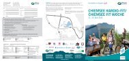
als PDF herunterladen - Prien am Chiemsee
als PDF herunterladen - Prien am Chiemsee
als PDF herunterladen - Prien am Chiemsee

Erfolgreiche ePaper selbst erstellen
Machen Sie aus Ihren PDF Publikationen ein blätterbares Flipbook mit unserer einzigartigen Google optimierten e-Paper Software.
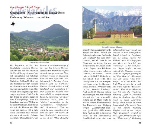
ins Urtal der <strong>Prien</strong>. Es ist eher<br />
ein Steig <strong>als</strong> ein Weg. In einem<br />
Örtchen mit dem passenden<br />
N<strong>am</strong>en Oed treten wir aus dem<br />
Wald hervor. Rechts hinter der<br />
Hauptstraße grüßt St. Florian,<br />
eine Wallfahrtskirche mit Brunnenkapelle<br />
an der Stelle, wo<br />
einst eine „Wunderquelle“ entsprungen<br />
war; einen Abstecher<br />
wäre das Idyll schon wert.<br />
Über einen Feldweg und ein<br />
Stück Teerstraße marschieren<br />
wir hinauf zum Leitenberg.<br />
Unten rauscht jetzt nicht mehr<br />
die <strong>Prien</strong>, sondern der unaufhörliche<br />
Verkehr der A8 München-<br />
Salzburg. Aber gleich nach der<br />
Autobahnbrücke, führt der Weg<br />
18<br />
We leave the forest near the village<br />
of Oed (= remote) - a fitting<br />
Kirche St. Florian, Rückseite des Schreinaltars<br />
Wasser<strong>am</strong>sel<br />
n<strong>am</strong>e.<br />
Beyond the main road, to the<br />
right, the pilgrimage church of<br />
St. Florian with its fountain chapel<br />
invites you to the spot where<br />
a “miraculous spring” is said to<br />
have emanated. This idyllic<br />
place is certainly worth a<br />
detour. We hike up to the Leitenberg<br />
via a field track and a piece<br />
of asphalt road. At the bottom<br />
there is now the endless flow of<br />
the traffic on the A8 Munich -<br />
Unterlauf der <strong>Prien</strong><br />
wieder hinunter ins Tal der <strong>Prien</strong><br />
und es wird ruhig und wohltuend<br />
grün.<br />
Weiter geht es auf dem <strong>Prien</strong>d<strong>am</strong>m.<br />
Dichter Auwald mit bunt<br />
wucherndem „Unkraut“ lässt<br />
übersehen, dass der Flusslauf<br />
hier bereits aus Schutzgründen<br />
verbaut und weitgehend begradigt<br />
ist. Bald ist auch der Wald<br />
zu Ende. Wer vor dem Einzug in<br />
Aschau noch eine halbe Stunde<br />
Zeit hat und nicht zu müde ist,<br />
könnte jenseits des Bummelbahngleises<br />
den Höhenberg<br />
Schlosskapelle<br />
(636 m) besteigen, wo seit dem<br />
12. Jahrhundert inmitten von<br />
vier Bauernhöfen die ehem.<br />
„Maierhofkirche“ zum Heiligen<br />
Kreuz aufragt. Der alte<br />
Herrschaftssitz Aschau schließlich<br />
bietet sich mit seinen vielen<br />
Gasthöfen (bis zur Spitzenklasse),<br />
der Burg (12. Jhdt.),<br />
dem dortigen <strong>Prien</strong>talmuseum<br />
und der K<strong>am</strong>penwandbahn <strong>als</strong><br />
ideales Tagesziel vor dem weiteren<br />
Bergaufwandern an.<br />
Wir haben seit dem <strong>Chiemsee</strong><br />
mindestens 13 Kilometer geschafft<br />
und stehen nun genau <strong>am</strong><br />
Fuß der Chiemgauer Alpen.<br />
Türkenbundlilie<br />
Salzburg instead of the murmuring<br />
river <strong>Prien</strong>. However, after<br />
the motorway bridge, the trail<br />
immediately descends into the<br />
silent and lush green <strong>Prien</strong> valley.<br />
We hike along the embankment<br />
of river <strong>Prien</strong>. The dense woodland<br />
with its proliferating<br />
“weeds” makes you forget that<br />
here the river is already fortified<br />
and straightened for safety reasons.<br />
Soon the forest ends. If you<br />
have half an hour of extra time<br />
before reaching Aschau and you<br />
are not too tired, you might hike<br />
up to the Höhenberg (636 m)<br />
beyond the railway line. Since<br />
the 12th century the former<br />
“Maierhof” Church of the Holy<br />
Cross has been located there<br />
<strong>am</strong>ongst four farm houses.<br />
Eventually, the old residential<br />
town of Aschau attracts you by<br />
its numerous top quality inns,<br />
the castle (12th century), the<br />
local <strong>Prien</strong> valley museum and<br />
the K<strong>am</strong>penwand cable car - an<br />
ideal day before hiking further<br />
uphill.<br />
We have walked at least 13 km<br />
away from lake <strong>Chiemsee</strong> and<br />
are now at the foothills of the<br />
“Chiemgauer” Alps.<br />
19