Current Conditions - USDA Forest Service
Current Conditions - USDA Forest Service
Current Conditions - USDA Forest Service

Create successful ePaper yourself
Turn your PDF publications into a flip-book with our unique Google optimized e-Paper software.
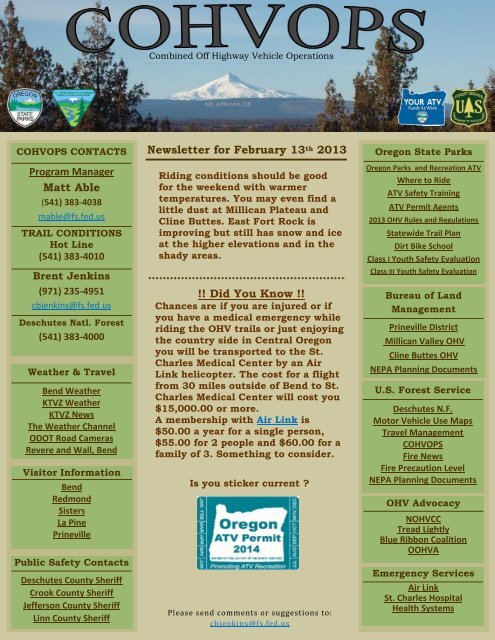
COHVOPS CONTACTS<br />
Program Manager<br />
Matt Able<br />
(541) 383-4038<br />
mable@fs.fed.us<br />
TRAIL CONDITIONS<br />
Hot Line<br />
(541) 383-4010<br />
Brent Jenkins<br />
(971) 235-4951<br />
cbjenkins@fs.fed.us<br />
Deschutes Natl. <strong>Forest</strong><br />
(541) 383-4000<br />
Weather & Travel<br />
Bend Weather<br />
KTVZ Weather<br />
KTVZ News<br />
The Weather Channel<br />
ODOT Road Cameras<br />
Revere and Wall, Bend<br />
Visitor Information<br />
Bend<br />
Redmond<br />
Sisters<br />
La Pine<br />
Prineville<br />
Public Safety Contacts<br />
Deschutes County Sheriff<br />
Crook County Sheriff<br />
Jefferson County Sheriff<br />
Linn County Sheriff<br />
Combined Off Highway Vehicle Operations<br />
Mt. Jefferson, OR<br />
Newsletter for February 13 th 2013<br />
Riding conditions should be good<br />
for the weekend with warmer<br />
temperatures. You may even find a<br />
little dust at Millican Plateau and<br />
Cline Buttes. East Fort Rock is<br />
improving but still has snow and ice<br />
at the higher elevations and in the<br />
shady areas.<br />
!! Did You Know !!<br />
Chances are if you are injured or if<br />
you have a medical emergency while<br />
riding the OHV trails or just enjoying<br />
the country side in Central Oregon<br />
you will be transported to the St.<br />
Charles Medical Center by an Air<br />
Link helicopter. The cost for a flight<br />
from 30 miles outside of Bend to St.<br />
Charles Medical Center will cost you<br />
$15,000.00 or more.<br />
A membership with Air Link is<br />
$50.00 a year for a single person,<br />
$55.00 for 2 people and $60.00 for a<br />
family of 3. Something to consider.<br />
Is you sticker current ?<br />
Please send comments or suggestions to:<br />
cbjenkins@fs.fed.us<br />
Oregon State Parks<br />
Oregon Parks and Recreation ATV<br />
Where to Ride<br />
ATV Safety Training<br />
ATV Permit Agents<br />
2013 OHV Rules and Regulations<br />
Statewide Trail Plan<br />
Dirt Bike School<br />
Class I Youth Safety Evaluation<br />
Class III Youth Safety Evaluation<br />
Bureau of Land<br />
Management<br />
Prineville District<br />
Millican Valley OHV<br />
Cline Buttes OHV<br />
NEPA Planning Documents<br />
U.S. <strong>Forest</strong> <strong>Service</strong><br />
Deschutes N.F.<br />
Motor Vehicle Use Maps<br />
Travel Management<br />
COHVOPS<br />
Fire News<br />
Fire Precaution Level<br />
NEPA Planning Documents<br />
OHV Advocacy<br />
NOHVCC<br />
Tread Lightly<br />
Blue Ribbon Coalition<br />
OOHVA<br />
Emergency <strong>Service</strong>s<br />
Air Link<br />
St. Charles Hospital<br />
Health Systems
East Fort Rock<br />
OPEN<br />
No Winter Maintenance <strong>Conditions</strong> during the<br />
No Maintenance winter. during the<br />
If you are winter. out in East Fort<br />
Rock<br />
If you<br />
and<br />
are<br />
see<br />
out<br />
something<br />
in East Fort<br />
that<br />
Rock and see something that<br />
needs our attention please<br />
needs our attention please<br />
give us call.<br />
Brent (971)235-4951<br />
Combined Off Highway Vehicle Operations<br />
Mt. Jefferson, OR<br />
Behind The Scenes & <strong>Current</strong> <strong>Conditions</strong><br />
Rim Butte<br />
In the Planning Stage<br />
We are hoping to start the<br />
development stage in July<br />
2013<br />
Rosland Play Area<br />
OPEN<br />
Winter <strong>Conditions</strong><br />
Spotters Are Required<br />
When Jumping<br />
ODOT PIT<br />
OPEN<br />
Spotters Are Required<br />
When Jumping<br />
Click On OHV Area Name For Directions From Bend<br />
Millican Plateau<br />
OPEN<br />
Good Dirt<br />
Crews are out working during<br />
the week. Please use extra<br />
caution if you are in the<br />
area.<br />
Please respect any closures<br />
South Millican<br />
CLOSED<br />
For The Season<br />
North Millican<br />
CLOSED<br />
For The Season<br />
Green Mountain<br />
OPEN<br />
Winter <strong>Conditions</strong><br />
Three Trails<br />
OPEN<br />
Winter <strong>Conditions</strong><br />
Over-The-Snow-Vehicles<br />
only.<br />
Groomed snowmobile routes<br />
are closed to<br />
wheeled vehicles<br />
Santiam Pass<br />
CLOSED<br />
Area closed to<br />
wheeled vehicles.<br />
Henderson Flats<br />
CLOSED<br />
For The Season<br />
Edison Butte<br />
CLOSED<br />
For The Season<br />
Cline Buttes<br />
OPEN<br />
Trails are drying out a bit.<br />
Watch for ice in the shady<br />
areas
Millican Valley<br />
5 MB<br />
Prints best on 11X17<br />
East Fort Rock<br />
6 MB<br />
Prints best on 11X17<br />
Cline Buttes<br />
4 MB<br />
Prints best on 11X17<br />
Combined Off Highway Vehicle Operations<br />
Mt. Jefferson, OR<br />
Trail Maps<br />
Three Trails<br />
1 MB<br />
Prints best on 8.5X11<br />
Edison Butte<br />
1.5 MB<br />
Prints best on 11X17<br />
Santiam Pass<br />
4 MB<br />
Prints best on 11X17<br />
Instructions<br />
Use in iOS devices with the Avenza PDF Maps App<br />
Or click the OHV area name to download the PDF file.<br />
If you have access to an iOS mobile device such as the<br />
iPad, iPhone or iPod Touch you can take some of the<br />
COHVOPS OHV Trail Maps with you using the Avenza<br />
PDF maps App.<br />
This handy free app allows GPS equipped iOS mobile<br />
devices to:<br />
View your location on the PDF trail map using the<br />
built-in GPS device (iPad, iPhone, iPod Touch)<br />
Measure distances and areas<br />
Plot waypoints<br />
View maps offline<br />
Here’s how:<br />
Install a QR code reader. Go to<br />
the App Store and search for QR code readers. Try:<br />
RL Classic.<br />
Next, install the Avenza PDF<br />
Maps app. Go to the App Store, search for Avenza<br />
and install their PDF Maps app.<br />
Open the QR code reader app and scan a QR code<br />
from the COHVOPS newsletter. The map download<br />
should begin.<br />
Map download and processing should happen<br />
automatically in the Avenza PDF Map app. It will<br />
take a short time to process the file to make it<br />
useable in the app.<br />
Tap the COHVOPS trail map. If you are located in<br />
the map extent your position should become<br />
apparent. You may need to refresh or update your<br />
current location.<br />
Email ghooper@fs.fed.us or call (541) 383-4724 with<br />
questions or comments
Combined Off Highway Vehicle Operations<br />
Mt. Jefferson, OR<br />
Sponsors And Volunteer Groups<br />
OMRA Oregon<br />
Motorcycle Riders<br />
Association<br />
www.omraoffroad.com<br />
Emerald Trail Riders<br />
Association<br />
www.etra.net<br />
Motorcycles Riders<br />
Association<br />
www.motorcycleriders<br />
association.org<br />
Oregon OHV<br />
Association<br />
www.oohva.org<br />
National Off-Highway<br />
Vehicle<br />
Conservation Council<br />
www.nohvcc.org/<br />
American<br />
Motorcyclist<br />
Association<br />
www.ama-cycle.org<br />
Ochoco Trail Riders<br />
www.ochocotrailriders.org<br />
Central Oregon<br />
Motorcycle and ATV<br />
Club<br />
www.comacclub.org<br />
Deschutes County<br />
4-Wheelers<br />
www.deschutescounty4wheelers.<br />
com<br />
Lobos Motorcycle<br />
Club<br />
www.lobosmc.com<br />
Raven Off-Road Club<br />
www.ravenoffroad.com<br />
Four Locked<br />
http://www.4lockedfilms.com<br />
The Moto Shop<br />
www.motoshopbend.com<br />
Phone: 541-383-0828<br />
G-Fab Motor Sports<br />
LLC<br />
www.gfabmotorsports.com<br />
Phone: 503-679-6692<br />
Redmond Powersports<br />
www.redmondpowersports.<br />
com<br />
Phone 541-504-4553<br />
Peak Performance<br />
www.team-peak.com<br />
Phone 541-536-3893