The restoration of tributaries of Cerknica Lake and Škocjan Caves ...
The restoration of tributaries of Cerknica Lake and Škocjan Caves ...
The restoration of tributaries of Cerknica Lake and Škocjan Caves ...

Create successful ePaper yourself
Turn your PDF publications into a flip-book with our unique Google optimized e-Paper software.
<strong>The</strong> <strong>restoration</strong> <strong>of</strong> <strong>tributaries</strong> <strong>of</strong> <strong>Cerknica</strong> <strong>Lake</strong> <strong>and</strong> <strong>Škocjan</strong> <strong>Caves</strong> Park<br />
Nataša Smolar-Žvanut 1 , Rok Fazarinc 2 , Borut Perič 3 , Sabina Blumauer 1 , Iztok Kavčič 1<br />
1 Institute for Water <strong>of</strong> the Republic <strong>of</strong> Slovenia, Hajdrihova 28c, 1000 Ljubljana<br />
2 Inženiring za vode d.o.o., Pod za Brdom 102, 1000 Ljubljana<br />
3 <strong>Škocjan</strong> <strong>Caves</strong> Park, <strong>Škocjan</strong> 2, 6215 Divača<br />
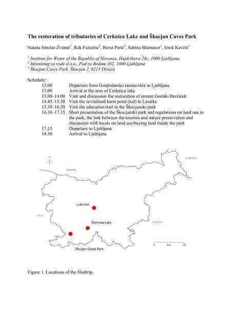
Schedule:<br />
12.00 Departure from Gospodarsko razstavišče in Ljubljana<br />
13.00 Arrival at the area <strong>of</strong> <strong>Cerknica</strong> lake<br />
13.00–14.00 Visit <strong>and</strong> discussion the <strong>restoration</strong> <strong>of</strong> stream Goriški Brežiček<br />
14.45–15.30 Visit the revitalised karst pond (kal) in Lasatke<br />
15.30–16.30 Visit the education trail in the <strong>Škocjan</strong>ski park<br />
16.30–17.15 Short presentation <strong>of</strong> the <strong>Škocjan</strong>ski park <strong>and</strong> regulations on l<strong>and</strong> use in<br />
the park, the link between the tourism <strong>and</strong> nature preservation <strong>and</strong><br />
discussion with locals on l<strong>and</strong> use/buying l<strong>and</strong> inside the park<br />
17.15 Departure to Ljubljana<br />
18.30 Arrival to Ljubljana<br />
Figure 1. Locations <strong>of</strong> the filedtrip.
1. CERKNICA LAKE<br />
1.1. Basic characteristics<br />
<strong>The</strong> <strong>Lake</strong> <strong>Cerknica</strong> is an intermittent lake appearing at the bottom <strong>of</strong> Cerkniško polje. It is<br />
the largest Slovenian turloughs <strong>and</strong> also one <strong>of</strong> the most important sites in Europe. It has very<br />
special conditions <strong>of</strong> the area with big diversity <strong>of</strong> plants, animals <strong>and</strong> habitats. In the past,<br />
people wanted to transform the area for their benefit. In order to do that, people have made a<br />
lot <strong>of</strong> interventions in the watercourses <strong>and</strong> sinkholes <strong>of</strong> the lake. All these interventions<br />
caused big changes <strong>of</strong> the water regime <strong>of</strong> the lake.<br />
Intermittent lake <strong>of</strong> <strong>Cerknica</strong> is not the lake in the true sense <strong>of</strong> the word, but it is the bottom<br />
<strong>of</strong> the karst field, which is filled during the autumn rains <strong>and</strong> usually remain flooded until the<br />
end <strong>of</strong> spring. <strong>The</strong> lake is filled in 2 to 3 days <strong>and</strong> covers about 29 km 2 . <strong>Lake</strong> inflows are<br />
mostly karst waters which originate in the southern <strong>and</strong> eastern edge <strong>of</strong> <strong>Cerknica</strong> field.<br />
<strong>Lake</strong> <strong>Cerknica</strong> belongs to karst region <strong>of</strong> the Ljubljanica river basin. <strong>The</strong> karst catchment area<br />
<strong>of</strong> Ljubljanica River is besides <strong>of</strong> the Trieste karst classified as one <strong>of</strong> the classic karst areas<br />
<strong>of</strong> Europe. One <strong>of</strong> the most interesting phenomena in this area is definitely intermittent <strong>Lake</strong><br />
<strong>Cerknica</strong> <strong>and</strong> specific are also streams Pivka, Unica, Ljubljanica <strong>and</strong> many limestone caves.<br />
Figure 2. <strong>The</strong> <strong>Cerknica</strong> lake (Photo: Rok Fazarinc).<br />
Hydrological area <strong>of</strong> <strong>Cerknica</strong> Karst Polje with <strong>tributaries</strong> measures 242 km 2 <strong>and</strong> two<br />
catchment areas <strong>of</strong> the <strong>Cerknica</strong> <strong>Lake</strong>, Loka <strong>and</strong> Bloke area, measures 185 km 2 <strong>and</strong> 47 km 2 .<br />
All together the catchment area <strong>of</strong> <strong>Lake</strong> <strong>Cerknica</strong> with <strong>tributaries</strong> covers about 474 km 2 ,<br />
which is almost 43% <strong>of</strong> total Ljubljanica river basin before it flows into Sava River.<br />
In addition to the inflow from the karst catchment area Loka field <strong>and</strong> Bloke plateau,<br />
<strong>Cerknica</strong> field has also water inflow <strong>of</strong> significant quantities <strong>of</strong> the surface or subsurface<br />
waters. From eastern <strong>and</strong> northern edge comes the water supplies from streams Lipsenjščica,<br />
Žirovniščica, Martinski potok, Grahovščica <strong>and</strong> Goriški Brežiček. On the western outskirts <strong>of</strong><br />
the field from under Javorniki flows the water through permanent or temporary springs<br />
Tresenc, Otoški Obrh, Mrzlek <strong>and</strong> through the Vranja cave <strong>and</strong> Suhodolnica. From the<br />
extreme north-east fringe comes the water supplies <strong>of</strong> the stream Cerkniščica the only one<br />
with appearance <strong>of</strong> non-Karst surface watercourse.<br />
In the first half <strong>of</strong> last century, the water management company made the reduction <strong>of</strong> sinks<br />
<strong>and</strong> some siphons, expansion <strong>and</strong> reduction <strong>of</strong> underground channels, regulation <strong>of</strong> the Stržen
stream in the length <strong>of</strong> 763 m, construction <strong>of</strong> drainage ditches, etc. <strong>The</strong>y were draining the<br />
swampy world with partly regulations <strong>of</strong> the stream Žirovniščica (2000 m), Lipsenjščica<br />
(1074 m), Tresenc (1146 m) <strong>and</strong> Goričko Brežička (1143 m). Drainage ditches were built in<br />
stream Lipsenj (758 m) <strong>and</strong> the river channel <strong>of</strong> Sržen was artificially straightened with the<br />
canal at Ključi (534 m).<br />
Figure 3. Hydrographic network with approximately area <strong>of</strong> <strong>Cerknica</strong> lake (Naravovarstveni<br />
atlas, June 2007).<br />
1.2. <strong>The</strong> aim <strong>of</strong> the LIFE + project<br />
In 2006 Notranjska Regional Park acquired fnancial support from European programme LIFE<br />
– Nature for project LIFE 06 (LIFE 06 NAT/SI/000069 "Intermittent <strong>Lake</strong> <strong>Cerknica</strong>"). <strong>The</strong><br />
purpose <strong>of</strong> this project was the establishment <strong>of</strong> appropriate conditions for protection <strong>and</strong><br />
conservation <strong>of</strong> animal <strong>and</strong> plant species <strong>and</strong> their habitats on <strong>Lake</strong> <strong>Cerknica</strong>. Factors that<br />
threaten the biodiversity on <strong>Lake</strong> <strong>Cerknica</strong> are modifed watercourses, ab<strong>and</strong>oning <strong>of</strong> meadow<br />
mowing <strong>and</strong> defcient knowledge <strong>of</strong> nature <strong>and</strong> its conservation.<br />
With the intention <strong>of</strong> maintaining biodiversity on <strong>Lake</strong> <strong>Cerknica</strong> our efforts were oriented to<br />
following actions:<br />
• Restoration <strong>of</strong> watercourses, that would contribute to higher water ground level <strong>and</strong><br />
retaining <strong>of</strong> overall water level on <strong>Lake</strong> <strong>Cerknica</strong><br />
• Composition <strong>of</strong> a Management plan, which serves as groundwork for managing the<br />
project area <strong>and</strong> is orientated towards conservation <strong>of</strong> natural <strong>and</strong> cultural heritage <strong>of</strong><br />
<strong>Lake</strong> <strong>Cerknica</strong><br />
• Mapping <strong>of</strong> habitat types with the intention <strong>of</strong> conserving the endangered ones<br />
• L<strong>and</strong> managing including buying, late mowing <strong>and</strong> mulching on the permanently<br />
protected l<strong>and</strong>.<br />
• Popularization <strong>of</strong> the project <strong>and</strong> education <strong>of</strong> the youth on the importance <strong>of</strong> nature<br />
conservation.<br />
<strong>The</strong> aim <strong>of</strong> the project was the <strong>restoration</strong> <strong>of</strong> former me<strong>and</strong>ers <strong>and</strong> by doing so retaining the<br />
water longer in the dry period <strong>and</strong> increasing the groundwater level in wetl<strong>and</strong> areas. We<br />
expected that in this way the ecological conditions <strong>of</strong> the wetl<strong>and</strong> areas, <strong>and</strong> thereby the living<br />
conditions for flora <strong>and</strong> fauna, improve.
Inženiring za vode d.o.o. produced the project documentation, based on a review <strong>of</strong> the<br />
situation on the terrain <strong>and</strong> examining the location <strong>of</strong> riverbeds as they were before the<br />
regulating operations began. More than 12 km <strong>of</strong> watercourses in the <strong>Cerknica</strong> area were<br />
included in the study.<br />
In 2009 <strong>restoration</strong> <strong>of</strong> selected watercourses was realized through LIFE+ project. 500m long<br />
parts <strong>of</strong> Goriški Brežiček <strong>and</strong> Tresenec streams were carried out. <strong>The</strong> experiences from this<br />
pilot <strong>restoration</strong> are needed to perform the <strong>restoration</strong> <strong>of</strong> all watercourses <strong>of</strong> the <strong>Lake</strong><br />
<strong>Cerknica</strong> in the coming years.<br />
Expected results <strong>of</strong> this <strong>restoration</strong>:<br />
- slower run<strong>of</strong>f <strong>of</strong> low waters from the area <strong>of</strong> the intermittent lake,<br />
- ground water level rise,<br />
- retention <strong>of</strong> water in depressions <strong>and</strong> stream branches, consequently higher constant<br />
ground water level height <strong>and</strong> change in the soil – water rate.<br />
By increasing length <strong>of</strong> streams, restoring former branches <strong>and</strong> me<strong>and</strong>ers, the water surface <strong>of</strong><br />
streams increased, which will have a positive effect on the conservation <strong>of</strong> aquatic, riparian<br />
<strong>and</strong> wetl<strong>and</strong> habitats.<br />
1.3. Hydrological characteristics <strong>of</strong> the Goriški Brežiček stream<br />
Due to the nature <strong>of</strong> the intermittent <strong>Cerknica</strong> lake, unique hydrologic <strong>and</strong> hydraulic regime is<br />
characteristic <strong>of</strong> the whole area. <strong>The</strong> regulated area is located within reach <strong>of</strong> the annual flood<br />
waters. Only the upper sections <strong>of</strong> the Tresenec stream <strong>and</strong> the Goriški Brežiček stream are<br />
situated on the edge <strong>of</strong> that area or out <strong>of</strong> the reach <strong>of</strong> the frequent flooding. Floods <strong>of</strong> the<br />
longer return periods inundate the whole area (e.g. in 2000 flood reached 552.05 m a.s.l. <strong>and</strong><br />
552.30 m a.s.l. in 1926). In such cases the highest points <strong>of</strong> the area are under more than 2 m<br />
<strong>of</strong> water, while most <strong>of</strong> the area is flooded by 3 meters.<br />
Table 1. Typical flow rates for the period<br />
Stream High water<br />
flow<br />
Mean<br />
annual<br />
flow<br />
m 3 /s m 3 /s m 3 /s<br />
Mean<br />
minimum<br />
flow<br />
Gorički Brežiček 1,7 0,16 0,009<br />
Cerkniščica 64,5 1,2 0,126<br />
1.4. Restoration <strong>of</strong> the Goriški Brežiček stream<br />
Restoring Goriški Brežiček stream was planned for the entire section, from the mill at the<br />
source, to its mouth in Lipsenjščica River, but only a part has been realized. <strong>The</strong> entire length<br />
<strong>of</strong> the stream has been straightened in the past, but given the terrain <strong>and</strong> vegetation, the<br />
original stream channel is still clearly visible.<br />
Restoring the original layout consisted <strong>of</strong> its deepening. Average width <strong>of</strong> the planned<br />
channel section was from 3.0 to 6.0 m. Excavation has been exercised in the form <strong>of</strong> U, with<br />
banks sloping 1:2, but it was planned that the transition slope <strong>of</strong> stream bank <strong>and</strong> terrain on<br />
majority <strong>of</strong> the length is carried out in a vertical slope <strong>and</strong> then let the water itself create a
stable bank. We assumed that the stability would be provided primarily by turf <strong>and</strong> partly by<br />
the riparian vegetation root system.<br />
Deepening <strong>of</strong> the stream bed at the juncture with the primary bottom at the upstream side has<br />
been protected by the small wooden weir (a small weir with the top corners at the bed level or<br />
just above it, which is not noticeable under normal hydrological conditions). Where possible,<br />
we predicted multiple channels with lower spills/overflows between the excavated me<strong>and</strong>ers.<br />
Figure 4. <strong>The</strong> Goriški Brežiček stream during the rainfall, January 2007. Straightened,<br />
regulated channel is seen in the foreground, while primary channel is seen in the background<br />
(Photo: Rok Fazarinc).<br />
Figure 5. <strong>The</strong> Goriški Brežiček stream after <strong>restoration</strong>, partly flooded, during higher water<br />
surface (March 2010) (Photo: Rok Fazarinc).<br />
Spills/overflows has been fortified with small wooden weirs (wooden piles, tree trunks) to<br />
prevent uncontrolled deepening <strong>of</strong> the spills/overflows. Spills/overflows were carried out<br />
above medium water level <strong>and</strong> they were covered with turf. At the appropriate locations at the<br />
contact <strong>of</strong> the current <strong>and</strong> planned section, there have also been carried out coves or bays,<br />
which are designed by keeping part <strong>of</strong> the current channel or in the area <strong>of</strong> inactive <strong>tributaries</strong>.
2. ŠKOCJAN CAVES<br />
2.1. <strong>The</strong> significance <strong>of</strong> the <strong>Škocjan</strong> <strong>Caves</strong><br />
<strong>The</strong> <strong>Škocjan</strong> <strong>Caves</strong> remain the only natural monument in Slovenia <strong>and</strong> the Classical Karst<br />
region on UNESCO’s list <strong>of</strong> natural <strong>and</strong> cultural world heritage sites. Thus, they hold a<br />
significant position among the world’s natural monuments. <strong>The</strong> first impression one gets <strong>of</strong><br />
the <strong>Škocjan</strong> karst surface is that it is flat but in fact it is not so. This typical l<strong>and</strong>scape that<br />
developed in limestones is named karst; the word being derived from the name <strong>of</strong> the area −<br />
Kras.<br />
<strong>The</strong> entry itself is important from different perspectives: most significantly, that the <strong>Škocjan</strong><br />
<strong>Caves</strong> have gained worldwide recognition <strong>and</strong> that the state has committed itself to doing<br />
everything in its power to conserve <strong>and</strong> protect this outst<strong>and</strong>ing natural site.<br />
<strong>The</strong> preparations for the establishment <strong>of</strong> the <strong>Škocjan</strong> <strong>Caves</strong> Regional Park began in the early<br />
1990s, with the <strong>Škocjan</strong> <strong>Caves</strong> Regional Park Act adopted in 1996. A year later, the Public<br />
Service Agency, which presently employs 21 people, began its operation as the Park's<br />
managing authority. In addition to adopting programmes for protection <strong>and</strong> development <strong>of</strong><br />
the park, constantly monitoring <strong>and</strong> analysing the status <strong>of</strong> natural <strong>and</strong> cultural heritage, the<br />
Public Service Agency performs numerous other tasks: it is responsible for the promotion <strong>of</strong><br />
the caves, research activity, education, infrastructure maintenance, as well as other activities.<br />
Co-operation with local residents is also important, especially those who are able to benefit<br />
from the park’s establishment.<br />
Figure 6. <strong>Škocjan</strong> caves park area (Photo: Nataša Smolar-Žvanut)<br />
<strong>The</strong> rapid development <strong>of</strong> the area that used to be a demographically <strong>and</strong> economically<br />
endangered region is reflected in the fact that the Park has obtained membership in various<br />
international institutions, which greatly contributes to the quality economic development both<br />
within the Divača Municipality <strong>and</strong> the Karst in Slovenia in general.
Figure 7. <strong>Škocjan</strong> cave with Reka river (http://www.park-skocjanske-jame.si/)<br />
Finally, the park was entered on another list under the auspices <strong>of</strong> UNESCO: <strong>The</strong> Ramsar<br />
Directory <strong>of</strong> Wetl<strong>and</strong>s <strong>of</strong> International Importance, which includes wetl<strong>and</strong>s which are<br />
important especially as waterfowl habitats. <strong>The</strong> <strong>Škocjan</strong> <strong>Caves</strong> were included in this list due<br />
to their important natural habitat comprising highly specialized <strong>and</strong> <strong>of</strong>ten endemic l<strong>and</strong> <strong>and</strong><br />
water cave animal species, among them the endemic cave salam<strong>and</strong>er (Proteus anguinus).<br />
Since 2004, the park is also a part <strong>of</strong> the Karst Biosphere Reserve network in the frame <strong>of</strong> the<br />
UNESCO MAB Program.<br />
2.2. Hydrology <strong>and</strong> description <strong>of</strong> the caves<br />
Water is one <strong>of</strong> the essential factors for developing the karst l<strong>and</strong>scape <strong>and</strong> it is also very<br />
important for life on karst. On Kras, which covers in the hydrological sense the area between<br />
the swallow-holes <strong>of</strong> the Reka River near <strong>Škocjan</strong> <strong>and</strong> the Timava springs near Trieste, this<br />
water is even more precious due to different access, high vulnerability <strong>and</strong> risk <strong>of</strong> pollution.<br />
Although the amount <strong>of</strong> precipitation is rather high (in general the average annual<br />
precipitations are from 14000 to 1650 mm per year) people in this area have always had<br />
difficulties with a good drinking water supply.<br />
<strong>The</strong> <strong>Škocjan</strong> <strong>Caves</strong> are a unique natural phenomenon, the creation <strong>of</strong> the Reka River. <strong>The</strong><br />
Reka River springs from below the Snežnik plateau <strong>and</strong> flows some fifty-five kilometres on<br />
the surface. Its average discharge between the ponors is 8.95 m 3 /s; during an extremely high<br />
flood it may even reach 387 m 3 /s. After heavy rainfall the river in the cave floods, usually the<br />
swollen water reaches the height <strong>of</strong> 30 m, the highest known rise in water level was 132 m.<br />
After reaching the Karst, that is the limestone surface, the river not only deepens its riverbed<br />
through erosion, but also by means <strong>of</strong> corrosion – it dissolves the limestone. In the first part <strong>of</strong><br />
its course on the limestone, the Reka still flows on the surface, along an approximately fourkilometre-long<br />
gorge that ends with a magnificent wall under which it disappears<br />
underground. <strong>The</strong> Reka River blind valley is the largest in Slovenia. In the distant past,<br />
probably in the Early Pleistocene, that is a few hundred thous<strong>and</strong> years ago, the ceiling <strong>of</strong> the<br />
cave collapsed some 200 metres from the sinks; as a result, the collapse dolines Velika dolina<br />
(up to 165 metres deep) <strong>and</strong> Mala dolina (120 metres) were created, separated by a natural<br />
bridge, a remnant <strong>of</strong> the original cave ceiling. Above the caves, between the wall above the<br />
sink <strong>and</strong> the walls <strong>of</strong> Mala dolina, lies the village <strong>of</strong> <strong>Škocjan</strong>. Close to the houses, there is
another entrance to the underground, a ninety-metre-deep abyss called Okroglica, which ends<br />
just above the underground Reka River.<br />
At the bottom <strong>of</strong> Velika dolina, the Reka River finally disappears underground <strong>and</strong> resurfaces<br />
again thirty-four kilometres away at the springs <strong>of</strong> the Timava River, not far from the Adriatic<br />
coast. Part <strong>of</strong> the <strong>Škocjan</strong> <strong>Caves</strong> in which the Reka River flows, namely the Šumeča jama (the<br />
Murmuring Cave), is 3.5 kilometres long, between 10 <strong>and</strong> 60 metres wide <strong>and</strong> over 100<br />
metres high underground canyon. <strong>The</strong> length <strong>of</strong> all cave passages totals approximately 6<br />
kilometres, while the vertical difference between the highest entrance (Okroglica abyss) <strong>and</strong><br />
the lowest point in the caves reached by man, that is the siphon, is 205 metres. At some<br />
places, the canyon extends into underground chambers. <strong>The</strong> largest <strong>of</strong> them, Martel's<br />
Chamber, is 308 metres long, 89 metres wide on average (reaching a maximum <strong>of</strong> 123<br />
metres) <strong>and</strong> 106 metres high, with the highest point <strong>of</strong> the ceiling at 146 metres above the<br />
Reka River bed. <strong>The</strong> largest cross-section measures 12,000 square metres, thus giving this<br />
chamber a volume <strong>of</strong> 2.2 million cubic metres.<br />
2.3. Projects <strong>and</strong> research activities<br />
One <strong>of</strong> the most important activities <strong>of</strong> the park is the encouragement <strong>and</strong> organization <strong>of</strong><br />
research work <strong>and</strong> participation in it. Following various inventories prepared at the time <strong>of</strong><br />
park’s establishment, the majority <strong>of</strong> activity is oriented towards the renovation <strong>of</strong> cave<br />
infrastructure <strong>and</strong> establishment <strong>of</strong> continuous monitoring, by means <strong>of</strong> which an adequate<br />
system for monitoring the situation will be established. It is reasonable to monitor all the<br />
parameters over the long term as it will enable rapid detection <strong>of</strong> negative effects on the<br />
environment <strong>and</strong> adequate responses or the adoption <strong>of</strong> certain measures aimed at alleviating<br />
these effects.<br />
For this purpose, different factors are monitored regularly: quality <strong>and</strong> quantity <strong>of</strong> water in the<br />
cave, microclimate in the cave, flora <strong>and</strong> fauna on the surface, cave fauna, cracks in the cave<br />
<strong>and</strong> on collapse doline walls <strong>and</strong> the influence <strong>of</strong> ground-level ozone on the surface.<br />
In order to achieve these objectives, the park regularly participates in invitations to tender<br />
(both internationally <strong>and</strong> nationally) so as to obtain the necessary funds for the purchase <strong>of</strong><br />
equipment, arrangement <strong>of</strong> infrastructure <strong>and</strong> the presentation <strong>of</strong> results to general public. In<br />
addition, some projects foresee the hiring <strong>of</strong> additional labour needed for project work.<br />
<strong>Škocjan</strong> Education Trail with museum collections (biology, geology, archaeology,<br />
ethnology <strong>and</strong> history <strong>of</strong> cave exploration) supports park educational programme which is<br />
orientated on different target groups. Within this programme many guided tours, exhibitions,<br />
workshops, seminars, events <strong>and</strong> excursions are organised.<br />
L<strong>and</strong> use in the park is oriented sustainably. <strong>The</strong>re are some prohibitions about depositing <strong>of</strong><br />
excavated material, activities that could change the purposed l<strong>and</strong> use, altering the water<br />
regime, pollution, use <strong>of</strong> open fire <strong>and</strong> motor vehicles etc. written in <strong>Škocjan</strong> <strong>Caves</strong> Regional<br />
Park Act. Habitats in the park are still well preserved. Polices for the forestry <strong>and</strong> agriculture<br />
derive from Natura 2000 Management Programme. Some prohibitions are specially written<br />
for the area <strong>of</strong> natural monuments which are mostly owned by the state. Less than 10 % <strong>of</strong> the<br />
park protected area (34,9 ha <strong>of</strong> 413 ha) belongs to Republic <strong>of</strong> Slovenia the rest is privately<br />
owned.
Figure 8. <strong>Škocjan</strong> cave viewpoint on education trail (http://www.park-skocjanske-jame.si/).<br />
Other activities<br />
<strong>The</strong> Public Service Agency manages the park as a public service, provided <strong>and</strong> partly<br />
financed by the founder. Within the framework <strong>of</strong> public service, the Agency performs<br />
several activities based on the <strong>Škocjan</strong> <strong>Caves</strong> Regional Park Act <strong>and</strong> the Decision<br />
Establishing the <strong>Škocjan</strong> <strong>Caves</strong> Park Public Service Agency. <strong>The</strong>se activities include<br />
maintenance, renovation <strong>and</strong> protection <strong>of</strong> monuments <strong>and</strong> sights in the area <strong>of</strong> the park;<br />
continuous monitoring <strong>and</strong> analysis <strong>of</strong> the state <strong>of</strong> valuable natural features <strong>and</strong> cultural<br />
heritage in the park; co-ordination <strong>of</strong> research tasks related to the park <strong>and</strong> organization <strong>of</strong><br />
research work; participation in international projects; public presentation <strong>of</strong> the park;<br />
execution <strong>and</strong> organization <strong>of</strong> educational activities; preparation <strong>and</strong> maintenance <strong>of</strong> paths<br />
<strong>and</strong> signs in the park; co-operation with the owners <strong>of</strong> individual monuments in the park;<br />
provision <strong>of</strong> pr<strong>of</strong>essional assistance <strong>and</strong> counselling; maintenance <strong>of</strong> cave infrastructure for<br />
cave visits <strong>and</strong> performance <strong>of</strong> guide services around the Park <strong>and</strong> caves; <strong>and</strong> Information<br />
Centre management.<br />
Cooperation with local people<br />
Cooperation with park inhabitants is exemplary <strong>and</strong> is reflected at all levels <strong>of</strong> social life,<br />
especially as regards the joint protection <strong>of</strong> natural <strong>and</strong> cultural heritage, joint work activities<br />
related to the maintenance <strong>and</strong> reconstruction <strong>of</strong> park infrastructure, the mowing <strong>and</strong> bringing<br />
in <strong>of</strong> hay <strong>and</strong> the cultivation <strong>of</strong> cultural l<strong>and</strong>scape. Of particular significance to the inhabitants<br />
is the assistance provided by the <strong>Škocjan</strong> <strong>Caves</strong> Park regarding the preparation <strong>of</strong> the<br />
necessary documentation related to the activities which affect the environment in the<br />
protected area <strong>of</strong> the park, joint commemoration <strong>of</strong> national holidays <strong>and</strong> local customs <strong>and</strong><br />
thus the integration <strong>of</strong> local inhabitants in permanent <strong>and</strong> periodic employment opportunities.<br />
<strong>The</strong> <strong>Škocjan</strong> <strong>Caves</strong> Park promotes <strong>and</strong> in agreement with the Ministry <strong>of</strong> the Environment<br />
<strong>and</strong> Spatial Planning (Regulation) financially supports the inhabitants in the park who<br />
renovate their homesteads under the expert supervision <strong>of</strong> competent services. Part <strong>of</strong><br />
renovated homesteads is used for tourist <strong>and</strong> catering activities, thus providing<br />
accommodation facilities in the park. <strong>The</strong> visitors thus have the opportunity <strong>of</strong> staying in the<br />
park more days which enable the local inhabitants to earn additional income. <strong>The</strong> <strong>Škocjan</strong><br />
Tourist Organization is very active in this respect, organizing on a yearly basis in April the<br />
traditional walking expedition along the Reka River sink hole <strong>and</strong> the festival <strong>of</strong> local amateur<br />
theatre groups which starts with the performance <strong>of</strong> choirs on Midsummer Night. <strong>The</strong> <strong>Škocjan</strong><br />
<strong>Caves</strong> Park participates in such activities both in the preparation <strong>and</strong> implementation phases.
2.4. Karst ponds<br />
Karst ponds contain practically the only st<strong>and</strong>ing waters in Kras. <strong>The</strong>y visibly mark the<br />
cultural l<strong>and</strong>scape <strong>and</strong> testify to an extremely economical method <strong>of</strong> using rainwater. In the<br />
regional sense, karst ponds create a network <strong>of</strong> marine biotopes that are important for the<br />
existence <strong>of</strong> numerous animal <strong>and</strong> plant species. Because <strong>of</strong> their exceptional diversity, caring<br />
for the preservation <strong>of</strong> every single karst pond is an important contribution to maintaining<br />
biotic diversity.<br />
In our filedtrip the karst pond in Lasatke will be visited, which was revitalised in the process<br />
<strong>of</strong> Phare project: 1001 karst ponds. It was revitalised in 2006 with contributions <strong>of</strong> Local<br />
Turist <strong>and</strong> Sport organisation, Local Hunting Association <strong>and</strong> <strong>The</strong> Institute <strong>of</strong> the Republic <strong>of</strong><br />
Slovenia for Nature Conservation <strong>and</strong> enthusiasm <strong>of</strong> deceased local biologist Igor Maher.<br />
Figure 9. Karst pons in Lasatke (Photo: Nataša Smolar-Žvanut).<br />
<strong>The</strong> supply <strong>of</strong> drinking water has always been a problem in karst regions, <strong>and</strong> ponds (kal) for<br />
watering cattle were therefore constructed in almost every village, from which water was<br />
originally taken for household use as well. As a rule, the ponds were located in the middle <strong>of</strong><br />
villages, at their edges, <strong>and</strong> only occasionally in the middle <strong>of</strong> pastures. Natural depressions<br />
were used or basins were dug. <strong>The</strong>se were coated with several layers <strong>of</strong> thoroughly trampled<br />
clay that held water better than today's cement coating, which tends to crack. <strong>The</strong> ponds were<br />
always constructed so that rainwater ran into them. If the ponds were located beside fields,<br />
paths, or roads, they were additionally protected with a stone wall to prevent soil from<br />
washing into them. Access to the water was adapted to use by animals, <strong>and</strong> the ponds were<br />
lined with several ridges to prevent slipping. Cleaning was done during the dry season when<br />
the accumulated mud from the bottom was removed <strong>and</strong> used as fertilizer. <strong>The</strong> cattle<br />
themselves helped maintain the ponds since they waded in the ponds while watering <strong>and</strong><br />
further trampled the clay, thus sealing any cracks developing on the bottom.<br />
Literature:<br />
Notranjski regijski park 2009: LAYMAN’S REPORT Project LIFE 06 NAT/SLO/000069 Intermittent <strong>Lake</strong><br />
<strong>Cerknica</strong>.<br />
<strong>Škocjan</strong> <strong>Caves</strong> Park (http://www.park-skocjanske-jame.si/)<br />
Inžinering za vode 2007: Project on river <strong>restoration</strong> <strong>of</strong> strems Goričkui Brežiček <strong>and</strong> Tresenec.