Federal Meteorological Handbook No. 1 - Marrella
Federal Meteorological Handbook No. 1 - Marrella
Federal Meteorological Handbook No. 1 - Marrella
You also want an ePaper? Increase the reach of your titles
YUMPU automatically turns print PDFs into web optimized ePapers that Google loves.
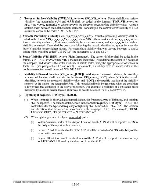
f. Tower or Surface Visibility (TWR_VIS_vvvvv or SFC_VIS_vvvvv). Tower visibility or surface<br />
visibility (see paragraphs 6.5.4 and 6.5.5) shall be coded in the formats, TWR_VIS_vvvvv or<br />
SFC_VIS_vvvvv, respectively, where vvvvv is the observed tower/surface visibility value. A space<br />
shall be coded between each of the remark elements. For example, the control tower visibility of 1 1/2<br />
statute miles would be coded "TWR VIS 1 1/2".<br />
g. Variable Prevailing Visibility (VIS_v vvvvVvvvvv). Variable prevailing visibility shall be<br />
n n n n n x x x x x<br />
coded in the format VIS_vvvvvVvvvvv, where VIS is the remark identifier, v vvvv is the<br />
n n n n n x x x x x n n n n n<br />
lowest visibility evaluated, V denotes variability between two values, and v vvvv is the highest<br />
x x x x x<br />
visibility evaluated. There shall be one space following the remark identifier; no spaces between the<br />
letter V and the lowest/highest values. For example, a visibility that was varying between 1/2 and 2<br />
statute miles would be coded "VIS 1/2V2" (see paragraphs 6.4.5 and 6.5.3).<br />
h. Sector Visibility (VIS_[DIR]_vvvvv) [Plain Language]. The sector visibility shall be coded in the<br />
format, VIS_[DIR]_vvvvv, where VIS is the remark identifier, [DIR] defines the sector to 8 points of<br />
the compass, and vvvvv is the sector visibility in statute miles, using the appropriate set of values in<br />
Table 12-1 (see paragraphs 6.4.6 and 6.5.7). For example, a visibility of 2 1/2 statute miles in the<br />
northeastern octant would be coded "VIS NE 2 1/2".<br />
i. Visibility At Second Location (VIS_vvvvv_[LOC]). At designated automated stations, the visibility<br />
at a second location shall be coded in the format VIS_vvvvv_[LOC], where VIS is the remark<br />
identifier, vvvvv is the measured visibility value, and [LOC] is the specific location of the visibility<br />
sensor(s) at the station (see paragraph 6.5.6). This remark shall only be generated when the condition<br />
is lower than that contained in the body of the report. For example, a visibility of 2 1/2 statute miles<br />
measured by a second sensor located at runway 11 would be coded "VIS 2 1/2 RWY11".<br />
j. Lightning (Frequency_LTG(type)_[LOC]).<br />
(1) When lightning is observed at a manual station, the frequency, type of lightning, and location<br />
shall be reported. The remark shall be coded in the format Frequency_LTG(type)_[LOC]. The<br />
contractions for the type and frequency of lightning shall be based on Table 12-5. The location<br />
and direction shall be coded in accordance with paragraph 12.7.c. For example, "OCNL<br />
LTGICCG OHD", “FRQ LTG VC", or "LTG DSNT W".<br />
(2) When lightning is detected by an automated system:<br />
(a) Within 5 nautical miles of the Airport Location Point (ALP), it will be reported as TS in<br />
the body of the report with no remark;<br />
(b) Between 5 and 10 nautical miles of the ALP, it will be reported as VCTS in the body of the<br />
report with no remark;<br />
(c) Beyond 10 but less than 30 nautical miles of the ALP, it will be reported in remarks only<br />
as LTG DSNT followed by the direction from the ALP.<br />
������������������������������������ �������������<br />
�����


