Managing the Urban Rural Interface - Plurel
Managing the Urban Rural Interface - Plurel
Managing the Urban Rural Interface - Plurel

Create successful ePaper yourself
Turn your PDF publications into a flip-book with our unique Google optimized e-Paper software.
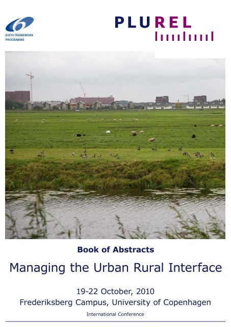
Book of Abstracts<br />
<strong>Managing</strong> <strong>the</strong> <strong>Urban</strong> <strong>Rural</strong> <strong>Interface</strong><br />
19-22 October, 2010<br />
Frederiksberg Campus, University of Copenhagen<br />
International Conference
<strong>Managing</strong> <strong>the</strong> <strong>Urban</strong> <strong>Rural</strong> <strong>Interface</strong>: Strategies and Tools for <strong>Urban</strong><br />
Development and Sustainable Peri-<strong>Urban</strong> Land Use Relationships<br />
International Conference • 19-22 October 2010<br />
Faculty of Life Sciences, University of Copenhagen<br />
Frederiksberg, Denmark<br />
Organisers<br />
PLUREL ASEM 4 th Symposium on <strong>Urban</strong> Forestry<br />
Landscape Tomorrow<br />
Danish Association of Landscape Ecologists<br />
Danish Architecture Centre<br />
International Union of Forest Research Organizations<br />
Organizing committee<br />
Chair: Kjell Nilsson, University of Copenhagen<br />
Hubert Wiggering, Leibniz-Centre for Agricultural Landscape Research – ZALF<br />
Wim Timmermanns, Wageningen University and Research Centre<br />
Ralf Seppelt, Helmholtz Centre for Environmental Research – UFZ<br />
Gertrud Jørgensen, University of Copenhagen<br />
Katharina Helming, Landscape Tomorrow<br />
Lone Kristensen, Danish Association of Landscape Ecologists<br />
Chen Xinliang, Chinese Academy of Forestry<br />
Karen Fabbri, DG Research, European Commission<br />
Niels Elers Koch, International Union of Forest Research Organizations<br />
Scientific committee<br />
Chair: Thomas Sick Nielsen, University of Copenhagen<br />
Vegard Skirbekk, International Institute for Applied System Analysis<br />
Mark Rounsevell, University of Edinburgh<br />
Carmen Aalbers, Alterra Green World Research<br />
Armin Werner, Leibniz-Centre for Agricultural Landscape Research – ZALF<br />
Annette Piorr, Leibniz-Centre for Agricultural Landscape Research – ZALF<br />
Dagmar Haase, Helmholtz-Centre for Environmental Research – UFZ<br />
Simon Bell, Edinburgh College of Arts<br />
Tim Taylor, University of Bath<br />
Stephan Pauleit, Munich Technical University<br />
Li Zhiyong, Chinese Academy of Forestry<br />
Hilda Blanco, University of Washington<br />
Christer Bengs, Swedish University of Agricultural Sciences<br />
Kai Böhme, Spatial Foresight GmbH<br />
Cecil C. Konijnendijk, University of Copenhagen<br />
Contact<br />
Danish Centre for Forest, Landscape and Planning, University of Copenhagen<br />
Rolighedsvej 23, 1958 Frederiksberg, Denmark<br />
E-mail: plurelconferce@life.ku.dk<br />
Internet: www.plurel.net/conference<br />
Design, Layout and Production<br />
Scandinavian Branding; Jette Alsing Larsen, Julien Grunfelder, Thomas Sick<br />
Nielsen, University of Copenhagen
List of co-chairs<br />
Topic 1: <strong>Urban</strong>-rural regions in a globalised world: driving forces on land use<br />
change<br />
Vegard Skirbekk, Research Scholar, International Institute for Applied Systems<br />
Analysis, Laxenburg, Austria<br />
Kai Böhme, Director, Spatial Foresight, Heisdorf, Luxembourg<br />
Topic 2: Scenarios: futures for rural-urban regions<br />
Mark Rounsevell, Professor, University of Edinburgh, Edinburgh, Scotland<br />
Topic 3: Land-use relationships and <strong>the</strong> structure of <strong>the</strong> rural-urban system:<br />
European and regional models<br />
Dagmar Haase, Professor, Helmholtz Centre for Environmental Research UFZ, Leipzig,<br />
Germany<br />
Hedwig v. Delden, Director, Research Institute for Knowledge Systems RIKS,<br />
Maastricht, The Ne<strong>the</strong>rlands<br />
Nina Schwarz, Postdoctoral Researcher, Helmholtz Centre for Environmental Research<br />
UFZ, Leipzig, Germany<br />
Topic 4: <strong>Rural</strong>-urban land use dynamics: impacts on resource demands and<br />
utilisation<br />
Annette Piorr, Agronomist, Leibniz Centre for Agricultural Landscape Research ZALF,<br />
Müncheberg, Germany<br />
Christer Bengs, Professor, Swedish University of Agricultural Sciences, Uppsala,<br />
Sweden<br />
Topic 5: Quality of life and ecosystem services in rural-urban regions<br />
Simon Bell, Associate Director, Open Space Research Centre, Edinburgh College of<br />
Arts, Edinburgh, Scotland<br />
Topic 6: Growth management and governance systems in rural-urban regions<br />
Hilda Blanco, Professor Emeritus, University of Washington, Seattle, United States<br />
Katarina Eckerberg, Senior Research Fellow, Stockholm Environment Institute,<br />
Stockholm, Sweden<br />
Topic 7: Locally adapted strategies for rural-urban regions: from<br />
understanding of issues to finding of solutions<br />
Carmen Aalbers, Alterra Green World Research, Wageningen University, Wageningen,<br />
The Ne<strong>the</strong>rlands<br />
Topic 8: Sustainable multifunctional landscapes in peri-urban areas<br />
Katharina Helming, Directorate, Landscape Tomorrow, Leibniz-Centre for Agricultural<br />
Landscape Research ZALF, Müncheberg, Germany<br />
Henrik Vejre, Associate Professor, University of Copenhagen, Frederiksberg, Denmark<br />
Topic 9: Economic evaluation of policies affecting land use in rural-urban<br />
regions<br />
Tim Taylor, Research Officer, University of Bath, Bath, England<br />
Topic 10: Instruments and tools for Sustainability Impact Assessment<br />
Armin Werner, Graduate agricultural engineer, Leibniz Centre for Agricultural<br />
Landscape Research ZALF, Müncheberg, Germany<br />
Topic 11: Sustainable <strong>Urban</strong> Development in Emerging Economies<br />
Stephan Pauleit, Professor, Munich Technical University, Germany<br />
Zhiyong Li, Professor, Chinese Academy of Forestry, Beijing, China<br />
Page 3 • <strong>Managing</strong> <strong>the</strong> <strong>Urban</strong> <strong>Rural</strong> <strong>Interface</strong> • 19-22 October 2010
Topic 12: <strong>Urban</strong> Forestry and <strong>Urban</strong> Greening in developing countries<br />
Cecil Konijnendijk, Professor, University of Copenhagen, Frederiksberg, Denmark<br />
Topic 13: Remote sensing and GIS for sustainable urban development science<br />
Maik Netzband, Research associate, University of <strong>the</strong> Rühr, Bochum, Germany<br />
Hannes Taubenböck, Research associate, University of Würzburg, Würzburg , Germany<br />
Page 4 • <strong>Managing</strong> <strong>the</strong> <strong>Urban</strong> <strong>Rural</strong> <strong>Interface</strong> • 19-22 October 2010
Table of contents<br />
Plenary session Keynote speakers<br />
Topic 1 <strong>Urban</strong>-rural regions in a globalised world:<br />
driving forces on land use change<br />
Topic 2 Scenarios: futures for rural-urban regions<br />
Topic 3 Land-use relationships and <strong>the</strong> structure of <strong>the</strong><br />
rural-urban system: European and regional<br />
models<br />
Topic 4 <strong>Rural</strong>-urban land use dynamics: impacts on<br />
resource demands and utilisation<br />
Topic 5 Quality of life and ecosystem services in ruralurban<br />
regions<br />
Topics 6 & 7 Growth Management, Governance Systems,<br />
Locally Adapted Strategies<br />
Topic 8 Sustainable multifunctional landscapes in periurban<br />
areas<br />
Topic 9 Economic evaluation of policies affecting land<br />
use in rural-urban regions<br />
Topic 10 Instruments and tools for Sustainability Impact<br />
Assessment<br />
Topic 11 Sustainable <strong>Urban</strong> Development in Emerging<br />
Economies<br />
Topic 12 <strong>Urban</strong> Forestry and <strong>Urban</strong> Greening in<br />
developing countries<br />
Topic 13 Remote sensing and GIS for sustainable urban<br />
development science<br />
List of Authors<br />
Page 5 • <strong>Managing</strong> <strong>the</strong> <strong>Urban</strong> <strong>Rural</strong> <strong>Interface</strong> • 19-22 October 2010<br />
7<br />
23<br />
35<br />
43<br />
53<br />
67<br />
83<br />
115<br />
127<br />
137<br />
149<br />
157<br />
165<br />
173
Page 6 • <strong>Managing</strong> <strong>the</strong> <strong>Urban</strong> <strong>Rural</strong> <strong>Interface</strong> • 19-22 October 2010
Page 7 • <strong>Managing</strong> <strong>the</strong> <strong>Urban</strong> <strong>Rural</strong> <strong>Interface</strong> • 19-22 October 2010<br />
Keynote speakers
Jorgina Cuixart Cardus¹, Rob Atkinson²<br />
¹EUROCITIES, Project Co-ordinator of URBAN MATRIX (EC FP6)<br />
²Professor, University of West of England, Academic Partner of<br />
URBAN MATRIX<br />
URBAN MATRIX: Knowledge Transfer among European<br />
Cities in addressing Sustainable <strong>Urban</strong> Development<br />
URBAN MATRIX was a FP6 funded project that successfully set up a knowledge transfer<br />
platform to support European cities in learning about projects and policies related to<br />
Sustainable <strong>Urban</strong> Development (SUD).<br />
This project was coordinated by EUROCITIES, <strong>the</strong> network of more than 140 major cities<br />
in Europe. The consortium included <strong>the</strong> Cities Research Centre at <strong>the</strong> University of <strong>the</strong><br />
West of England, GHK Consulting as well as nine European cities as key partners:<br />
Amsterdam, Helsinki, Seville, Malmo, Belfast, San Sebastian, Palermo, Stockholm and<br />
Sheffield.<br />
The Problem<br />
Local governments play an important role in implementing sustainable urban<br />
development policies. Ideally, decision-makers in city authorities should be fully aware of<br />
<strong>the</strong> latest research findings, <strong>the</strong> range of available solutions, and current legislation and<br />
best practices on this field; however, this information is not always accessible or<br />
disseminated in a timely and appropriate format. Therefore, <strong>the</strong>re is a need for crosschecking<br />
<strong>the</strong> supply of information and <strong>the</strong> demand for solutions on Sustainable <strong>Urban</strong><br />
Development (SUD) policies and practices, so city practitioners can benefit from this<br />
“knowledge and know how” and contribute to a greater urban sustainability.<br />
The Project objectives<br />
The overall objectives of <strong>the</strong> project were to:<br />
� chart cities demands for knowledge on urban sustainability issues;<br />
� organize <strong>the</strong> supply of existing information available (research results and best<br />
practice);<br />
� develop a methodology to match supply and demand – through an interactive website<br />
portal and knowledge exchange events;<br />
� evaluate this project methodology and make recommendations to <strong>the</strong> European<br />
Commission on effective means for exploiting and communicating existing knowledge<br />
and expertise.<br />
The Methodology<br />
Through three annual surveys (2007, 2008, 2009), URBAN MATRIX built up a picture of<br />
<strong>the</strong> knowledge demand of European cities on SUD issues and <strong>the</strong> obstacles <strong>the</strong>y<br />
encountered in accessing knowledge relevant to <strong>the</strong>ir needs. Based on <strong>the</strong>se results, <strong>the</strong><br />
project organised a collection of tested practices and research outcomes. The knowledge<br />
so ga<strong>the</strong>red is publicly available in <strong>the</strong> URBAN MATRIX e-library which is linked to <strong>the</strong><br />
wider European <strong>Urban</strong> Knowledge Network (EUKN) and available at www.urbanmatrix.net.<br />
In addition, <strong>the</strong>matic workshops were held each year, offering transferable<br />
examples of best practice and facilitating mutual learning between city practitioners and<br />
researchers.<br />
The Results<br />
Even though <strong>the</strong> number of partner cities is limited, <strong>the</strong> project provides benefits to a<br />
wider group of local authorities who took part in <strong>the</strong> project activities. The surveys and<br />
direct encounters with city administrations through <strong>the</strong> workshops allowed us to improve<br />
<strong>the</strong> dissemination of knowledge on SUD. Through <strong>the</strong> surveys we were able to identify a<br />
‘knowledge dissemination deficit’ that needed to be addressed at all levels from <strong>the</strong><br />
European to <strong>the</strong> local.<br />
Page 8 • <strong>Managing</strong> <strong>the</strong> <strong>Urban</strong> <strong>Rural</strong> <strong>Interface</strong> • 19-22 October 2010
Through <strong>the</strong> production of recommendations on how to improve dissemination of future<br />
research results, <strong>the</strong> project has influenced EU urban policy and how it is implemented in<br />
cities. The URBAN MATRIX Recommendations provide a number of proposals to <strong>the</strong><br />
European Commission on <strong>the</strong> design of future EU research funding for Sustainable <strong>Urban</strong><br />
Development that responds to <strong>the</strong> current knowledge needs of cities, supports successful<br />
tools for knowledge exchange and transfer and increases <strong>the</strong> profile of <strong>the</strong> urban agenda<br />
in <strong>the</strong> EU’s research funding programmes.<br />
Page 9 • <strong>Managing</strong> <strong>the</strong> <strong>Urban</strong> <strong>Rural</strong> <strong>Interface</strong> • 19-22 October 2010
Bob Evans<br />
Professor<br />
Northumbria University<br />
<strong>Urban</strong>ity, <strong>Rural</strong>ity, Governance and Resilience<br />
In both public policy and academic writing it has become commonplace to refer to ‘urban<br />
sustainability’ or to <strong>the</strong> more vague and aspirational concept of ‘<strong>the</strong> sustainable city’. This<br />
latter notion is particularly fraught with difficulty since, as has been regularly argued, <strong>the</strong><br />
concept of <strong>the</strong> sustainable city is an oxymoron. Cities are consumers of people, resources,<br />
energy and raw materials – <strong>the</strong>y need <strong>the</strong>se to survive - and although town and city<br />
governments can strive to adopt more ecological and carbon neutral policies and<br />
sustainable lifestyles for <strong>the</strong>ir citizens, it is doubtful whe<strong>the</strong>r any city can truly claim <strong>the</strong><br />
title ‘sustainable’, since <strong>the</strong>re will always a reliance upon some kind of ‘hinterland’, near<br />
or distant.<br />
This paper will explore <strong>the</strong> concept of <strong>the</strong> sustainable city within <strong>the</strong> context of its<br />
‘territory’ – as opposed to its ‘hinterland’. The sustainability agenda requires new ways of<br />
thinking about <strong>the</strong> urban-rural relationship and <strong>the</strong> policy and political changes that this<br />
will require The paper will argue that it is no longer helpful to view our collective futures<br />
through <strong>the</strong> lens of <strong>the</strong> polarized concepts of rural and urban. Moreover, it will be argued,<br />
if our increasingly urban European society is to develop <strong>the</strong> resilience and associated<br />
transition strategies to meet unpredictable, non-linear and possibly rapid social,<br />
economic and environmental change <strong>the</strong>n <strong>the</strong> wider issues of governmental structure,<br />
governance and citizen engagement become even more important.<br />
Page 10 • <strong>Managing</strong> <strong>the</strong> <strong>Urban</strong> <strong>Rural</strong> <strong>Interface</strong> • 19-22 October 2010
Birgit Georgi<br />
Project Manager - <strong>Urban</strong> issues<br />
European Environment Agency<br />
The Challenges of sustainable <strong>Urban</strong> Development in<br />
Europe and its Consequences for <strong>Rural</strong>-<strong>Urban</strong><br />
Relationships<br />
Europe is a highly urbanised continent with a long tradition of cities. Currently, around<br />
75% of <strong>the</strong> European population live in cities and this percentage is expected to fur<strong>the</strong>r<br />
increase. Hence, although covering just around 4% of Europe’s surface, cities’ influence<br />
goes far beyond <strong>the</strong>ir borders deep into <strong>the</strong> rural hinterland.<br />
Meanwhile overall land use changes in Europe slowed down over <strong>the</strong> last years, <strong>the</strong> rate of<br />
urban growth fur<strong>the</strong>r increased in <strong>the</strong> period between 2000 and 2006 compared to <strong>the</strong><br />
nineties. In contrast to <strong>the</strong> nineties, <strong>the</strong> growth of residential areas seemed to have slowed<br />
down but <strong>the</strong> extension rate of commercial and construction sites has accelerated. In<br />
particular, that type of sprawl happens not only around cities but reaches far into <strong>the</strong><br />
rural hinterland, preferable in proximity to major transport infrastructure. As <strong>the</strong>se are<br />
<strong>the</strong> trends for Europe as a whole, big differences can exist between <strong>the</strong> countries and<br />
regions. For instance between 2000 and 2006, <strong>the</strong> rate of urban growth varied between<br />
close to 0 and 5% per year; in some countries, housing was <strong>the</strong> main driver, meanwhile in<br />
o<strong>the</strong>rs it was ra<strong>the</strong>r industry and construction.<br />
Artificial land up take happened mostly on agricultural land which in turn put fur<strong>the</strong>r<br />
pressure on natural and semi-natural areas. Toge<strong>the</strong>r with <strong>the</strong> fur<strong>the</strong>r fragmentation of<br />
rural areas this feeds land use conflicts. Less area becomes available for <strong>the</strong> production of<br />
food and biofuels, for nature and biodiversity, and <strong>the</strong> delivery of important ecosystem<br />
services for <strong>the</strong> urban and <strong>the</strong> rural population.<br />
On European average, <strong>the</strong> urban area increased faster than <strong>the</strong> population led to a<br />
decrease in population density. This reduces <strong>the</strong> resource efficiency potential of urban<br />
areas in terms of transport demand, land and energy consumption and increases <strong>the</strong><br />
ecological footprint of cities. <strong>Urban</strong> sprawl far into <strong>the</strong> hinterland blurs increasingly <strong>the</strong><br />
differences between urban and rural, created substantial low dense and scattered periurban<br />
space und spread urban impacts in rural areas even more.<br />
Fur<strong>the</strong>r urbanisation in Europe posses not only threats to <strong>the</strong> environment, but offers<br />
also a potential for a more sustainable Europe. The challenge is to find a balanced concept<br />
by promoting urban density to improve resource efficiency but create never<strong>the</strong>less<br />
attractive cities with high quality public and green space. In fact, it seems that a number<br />
of cities become attractive again, letting assume that <strong>the</strong>y provide a good quality of life. In<br />
nearly a third of bigger city regions <strong>the</strong> population grew faster or shrunk less than in <strong>the</strong><br />
hinterland. Cities can become more efficient and attractive and contribute thus to a<br />
reduction of urban sprawl; however, <strong>the</strong>y can never be completely self-sustaining. A<br />
balanced concept includes a strong co-operation with <strong>the</strong> rural hinterland and its services<br />
– a hinterland that can reach as far as Asia or South-America producing food and o<strong>the</strong>r<br />
goods consumed in European cities.<br />
Fur<strong>the</strong>r information:<br />
EEA land use: http://www.eea.europa.eu/<strong>the</strong>mes/landuse<br />
EEA urban environment: http://www.eea.europa.eu/<strong>the</strong>mes/urban<br />
IUME Working platform (Integrated <strong>Urban</strong> Monitoring in Europe):<br />
http://iume.ew.eea.europa.eu/<br />
Page 11 • <strong>Managing</strong> <strong>the</strong> <strong>Urban</strong> <strong>Rural</strong> <strong>Interface</strong> • 19-22 October 2010
June Graham<br />
Project Co-ordinator of URBAN ERANET<br />
Scotland & Nor<strong>the</strong>rn Ireland Forum for Environmental Research<br />
Increased Coordination of <strong>Urban</strong> Sustainability Research<br />
in Europe<br />
Sustainable urban development - <strong>the</strong> focus of URBAN-NET<br />
URBAN-NET is an EC Framework Programme 6 European Research Area Network (ERA-<br />
Net). ERA-Nets provide a framework for ministries and research councils implementing<br />
public research programmes to coordinate <strong>the</strong>ir activities e.g. by developing joint<br />
activities or by mutually supporting joint calls for transnational proposals. URBAN-NET<br />
comprises national and regional research managers, funders and facilitators from 12<br />
countries across Europe; Austria, Bulgaria, Cyprus, France, Germany, Ne<strong>the</strong>rlands,<br />
Portugal, Romania, Spain, Sweden, Turkey and Scotland. The project started in August<br />
2006 and was recently extended for a fur<strong>the</strong>r 9 months until April 2010.<br />
URBAN-NET aims to structure and coordinate research on urban sustainability in Europe<br />
by identifying and addressing trans-national requirements for research and sharing of<br />
good practice, in order to support <strong>the</strong> implementation of <strong>the</strong> European Research Area in<br />
<strong>the</strong> urban research field, as well as o<strong>the</strong>r European policies and strategies relating to<br />
sustainable urban development.<br />
URBAN-NET ‘s core <strong>the</strong>me for research is integrated approaches to urban planning and<br />
management. Specific areas for research have emerged through <strong>the</strong> process of identifying<br />
common strategic issues with an emphasis on <strong>the</strong> interactions between urban functions<br />
and sectors.<br />
Activitities:<br />
� Compiled an online database of European urban research programmes.<br />
� Coordinated 2 transnational calls for collaborative urban research resulting in <strong>the</strong><br />
funding of 16 projects to a total sum of 8 million Euros.<br />
� Published a Strategic Research Framework Agenda which identifies priority<br />
research areas, key issues and principles for urban research programmes;<br />
� Networked with o<strong>the</strong>r projects, associations, funding bodies etc to influence<br />
strategic agendas and initiatives including a Joint Programming Initiative (JPI)<br />
on <strong>Urban</strong> Europe plus o<strong>the</strong>r JPIs on demography and on climate change, plus<br />
research element of <strong>the</strong> Toledo Declaration signed by Ministers responsible for<br />
housing and urban development.<br />
Page 12 • <strong>Managing</strong> <strong>the</strong> <strong>Urban</strong> <strong>Rural</strong> <strong>Interface</strong> • 19-22 October 2010
Marcel Houtzager<br />
Regional Portfolio Holder on Green Policy, Recreation and Tourism<br />
The Hague Region<br />
Regional Spatial Policy with a Green Pillar in The Hague<br />
Region<br />
The Hague Region is part of <strong>the</strong> Western conglomeration in <strong>the</strong> Ne<strong>the</strong>rlands called<br />
Randstad. It is <strong>the</strong> most urbanised part of The Ne<strong>the</strong>rlands and comprises roughly <strong>the</strong><br />
four provinces with <strong>the</strong> four biggest cities: Amsterdam, Rotterdam, The Hague and<br />
Utrecht.<br />
The spatial policy of The Hague Region is determined by <strong>the</strong> spatial developments in<br />
Randstad Holland and is characterised by enormous expansion of <strong>the</strong> built up area and<br />
big pressure on <strong>the</strong> green areas. Because of <strong>the</strong> various demands on land use <strong>the</strong><br />
necessity exists for clear steering policy.<br />
The specifics of <strong>the</strong> spatial and green policy in The Hague Region are defined by <strong>the</strong> fact<br />
that <strong>the</strong> green areas lie entirely enclosed by big cities. The cultural-historic value of <strong>the</strong><br />
landscapes is often under pressure. Developers are eager to take every possible chance.<br />
Recreation needs to be carefully steered (with good accessibility, enough parking places,<br />
information boards, facilities, etc). Exchange between city and countryside is being<br />
encouraged: local products, slow food initiatives, care providing farms, specific recreation<br />
needs for <strong>the</strong> expat community and <strong>the</strong> new Dutch citizens.<br />
The present spatial policy in The Hague Region encompasses of a Regional Structure<br />
Plan, a Green Policy Plan, Green Funds and Execution Program. The region is operating<br />
in close cooperation with Central and Provincial government, <strong>the</strong> branch organisation of<br />
<strong>the</strong> farmers, <strong>the</strong> Water Boards and <strong>the</strong> private sector. It sustains well-functioning green<br />
areas (ecologically sustainable and vital). Special attention is being paid to biodiversity<br />
and water quality. One of <strong>the</strong> key tasks of <strong>the</strong> region is ensuring a good balance between<br />
urban and peri-urban through integrated planning and inter-municipal cooperation. The<br />
region strives after building 80% of <strong>the</strong> new developments within <strong>the</strong> city boundaries,<br />
connects development of green areas with public transport, and develops parking<br />
facilities at <strong>the</strong> edges of <strong>the</strong> cities.<br />
The challenges that lie ahead of <strong>the</strong> region are quite a few - efficient regional steering,<br />
attracting investments, developing fur<strong>the</strong>r <strong>the</strong> Spatial Strategy, Investment Program and<br />
Process Agreements, ensuring good partnership with o<strong>the</strong>r authorities, <strong>the</strong> private sector<br />
and <strong>the</strong> research community. The Hague Region has been a case study region in PLUREL<br />
and has learned a lot about cooperation with science. The regional portfolio holder on<br />
Green, Tourism and Recreation M. Houtzager has been on <strong>the</strong> Board of Stakeholders of<br />
<strong>Plurel</strong> and has worked intensively to assure good understanding of <strong>the</strong> practical<br />
applicability of end results of <strong>Plurel</strong>. Applicability of <strong>the</strong> end-results is essential for <strong>the</strong><br />
success of future cooperation between policymakers and researchers and <strong>the</strong> effects of<br />
research on regional and European policy.<br />
Page 13 • <strong>Managing</strong> <strong>the</strong> <strong>Urban</strong> <strong>Rural</strong> <strong>Interface</strong> • 19-22 October 2010
Binyi Liu<br />
Professor, Chairman of Landscape studies department, Director of<br />
Landscape Science Research Institute<br />
Tongji University<br />
The Development Trend of <strong>the</strong> <strong>Rural</strong>-<strong>Urban</strong> Fringe and its<br />
Response Pattern of Planning in China<br />
During China's urbanization process, <strong>the</strong> rural-urban fringe shows <strong>the</strong> urbanization<br />
trends developing from countryside to <strong>the</strong> modern city, which leads to <strong>the</strong> main issues<br />
including <strong>the</strong> nature of land conversion and <strong>the</strong> corresponding mechanisms for<br />
supporting <strong>the</strong> policy, industrial distribution and that of <strong>the</strong> proportion in three<br />
industries, <strong>the</strong> new living environment, <strong>the</strong> change of ecology from <strong>the</strong> original<br />
countryside environment to modern urban environment, and <strong>the</strong> change in existing<br />
cultural habits, and so on. This paper will describe and discuss issues including <strong>the</strong><br />
current situation, development trends and its response pattern of <strong>the</strong> planning.<br />
In <strong>the</strong> Pearl River Delta, one of <strong>the</strong> typical regions, rural-urban fringes which have lush<br />
vegetation throughout <strong>the</strong> year, forming a rich green landscape are mostly located in <strong>the</strong><br />
river water network. To promote <strong>the</strong> city's rapid expansion, large villages and widespread<br />
real estate development projects appear in <strong>the</strong> rural-urban fringe. Three situations come:<br />
<strong>the</strong> urban complex surrounded by <strong>the</strong> countryside villages, <strong>the</strong> countryside villages were<br />
surrounded by <strong>the</strong> urban settlements, as well as <strong>the</strong> co-existence and complex hybrid of<br />
urban and rural. Focusing on <strong>the</strong> Pearl River Delta region cored by Guangzhou City,<br />
issues about <strong>the</strong> existing situation and its development trend of <strong>the</strong> space; <strong>the</strong> orientation<br />
of land-use planning; decision-making and management of <strong>the</strong> land-use; <strong>the</strong> public<br />
participation in planning, decision-making and management were described and<br />
analyzed.<br />
As an upcoming urbanization area, Pengshan Platform, in Shengzhou City, Zhejiang<br />
Province, China, ranged about 30 square kilometers, is one of <strong>the</strong> typical rural-urban<br />
fringe area. It is facing <strong>the</strong> same problems in its development. In its planning process, a<br />
regional planning approach of "reverse urbanization” was created: based on <strong>the</strong> regional<br />
coordination, <strong>the</strong> elements of <strong>the</strong> Feng-shui of <strong>the</strong> region, geographical features, animals<br />
and plants, landscape ecology, <strong>the</strong> visual landscape, <strong>the</strong> original inhabitants, culture,<br />
history and <strong>the</strong> o<strong>the</strong>rs were considered. Using sustainable ecological development as <strong>the</strong><br />
prestige, <strong>the</strong> new pattern of <strong>the</strong> urban development was discovered from <strong>the</strong> three scales,<br />
<strong>the</strong> macro-region context, middle region context of <strong>the</strong> urban-region of convergence with<br />
<strong>the</strong> old city, and <strong>the</strong> micro area context of <strong>the</strong> project, for <strong>the</strong> purpose of proper planning<br />
land use, guiding industrial development, promoting green infrastructure construction.<br />
The project provides a new way of thinking on <strong>the</strong> patterns of development and<br />
construction in <strong>the</strong> rural-urban fringe area, <strong>the</strong> development of ecological new city and<br />
landscape environment conservation and restoration.<br />
Page 14 • <strong>Managing</strong> <strong>the</strong> <strong>Urban</strong> <strong>Rural</strong> <strong>Interface</strong> • 19-22 October 2010
Hilary Lowson<br />
PURPLE secretary<br />
PURPLE network<br />
Bridging <strong>the</strong> Gap between Research and Policy Making in<br />
Peri-<strong>Urban</strong> Regions<br />
The PURPLE network (www.purple-eu.org) consists of 15 large regions, sharing a mix of<br />
peri-urban characteristics, and acknowledging common challenges, opportunities and<br />
policy goals. Since 2004, PURPLE members have been working for recognition and<br />
awareness of peri-urban issues particularly in EU policy. PURPLE’s policy makers, its<br />
politicians and experts in regional and local government, provide a constituency for<br />
PLUREL and similar research projects. Purple members work in an environment that is<br />
characterised by a lack of clarity about <strong>the</strong> impact of policy instruments, a constant need<br />
to compromise, often with short implementation periods ruled by relatively short political<br />
cycles.<br />
The peri-urban regions and research<br />
Acknowledging that our territories are complex and multi-functional, PURPLE members<br />
need <strong>the</strong> support of targeted research which can provide evidence: what is happening,<br />
what are likely impacts, what is <strong>the</strong> timescale, what works and what actions bring what<br />
results? Such evidence underpins policy arguments and enables qualitative and<br />
quantitative comparison of options. The political dimension of policy making means that<br />
‘difficult’ decisions – those which may be potentially unpopular, or expensive, or just<br />
unfamiliar - lose out.<br />
Research can help support policy development which is innovative as well as bolder and<br />
more radical by demonstrating what <strong>the</strong> pressures are and how to respond most<br />
effectively. In practice does this happen as much as it should – given <strong>the</strong> amount of<br />
potentially relevant research that is funded?<br />
The ‘Gap’<br />
� Researchers and policy makers have different priorities and goals<br />
� They work to different timescales (remember <strong>the</strong> policy cycles…)<br />
� Researchers do not acknowledge <strong>the</strong> complexity of peri-urban regions and how<br />
policy issues overlap and compete. They need a clear understanding of<br />
governance structures, how <strong>the</strong>y work, how decisions are made and <strong>the</strong><br />
constraints under which politicians and <strong>the</strong>ir officials are operating.<br />
� Communication is a hurdle in terms of language/jargon and presentation. Policy<br />
makers find it difficult to access information about relevant research (even at <strong>the</strong><br />
university ‘up <strong>the</strong> road’), and <strong>the</strong>n difficult to understand it and fix its relevance<br />
to <strong>the</strong> specific local problem or issue.<br />
� Even if <strong>the</strong> researchers are more pro-active and <strong>the</strong>ir results are made available,<br />
<strong>the</strong>ir presentation is often ano<strong>the</strong>r barrier, so it takes too much time to read and<br />
understand <strong>the</strong>m and <strong>the</strong>n work out how to adapt <strong>the</strong>m to a local problem.<br />
Clearer presentation and syn<strong>the</strong>sis – a focus on what is relevant (backed up by<br />
<strong>the</strong> detail) – is needed.<br />
Some possible solutions?<br />
� Developing a peri-urban research network<br />
� Annual meetings between researchers and policy makers<br />
� PURPLE members on research project steering groups<br />
� Researchers seek PURPLE endorsement of <strong>the</strong>ir proposals at an early stage of<br />
development.<br />
Page 15 • <strong>Managing</strong> <strong>the</strong> <strong>Urban</strong> <strong>Rural</strong> <strong>Interface</strong> • 19-22 October 2010
Kjell Nilsson¹, Thomas Sick Nielsen²<br />
¹Coordinator of <strong>the</strong> PLUREL Integrated Project, Deputy Director at <strong>the</strong><br />
Danish Centre for Forest, Landscape and Planning<br />
²Project Manager of <strong>the</strong> PLUREL Integrated Project, Senior<br />
Researcher at <strong>the</strong> Danish Centre for Forest, Landscape and Planning<br />
University of Copenhagen<br />
Strategies and Tools for <strong>Urban</strong> Development and<br />
Sustainable Peri-<strong>Urban</strong> Land Use Relationships (PLUREL)<br />
<strong>Urban</strong>isation has arguably been <strong>the</strong> most significant process of land use change in Europe<br />
since <strong>the</strong> Second World War. Over 70% of Europe’s population now lives in urban areas,<br />
which in turn have grown in area by almost 80% over <strong>the</strong> last fifty years (EEA, 2006). The<br />
most obvious signs of this shift towards urbanisation are urban sprawl and <strong>the</strong> emergence<br />
of peri-urban areas, characterised by scattered built-up residential, industrial or<br />
commercial areas and dense transport networks, but also by <strong>the</strong> establishment in some<br />
places of green belts, recreational facilities, urban woodlands and golf courses, <strong>the</strong><br />
conversion of farmstead complexes into housing and changes from conventional<br />
agricultural land uses into hobby farms and rural areas within easy reach of <strong>the</strong> city.<br />
The different spatial patterns, cultures, planning policies, and various driving forces of<br />
urban growth or decline, result in changes of land use and functional linkages between<br />
urban and rural areas. The changing nature of <strong>the</strong> relationships between rural and urban<br />
land uses has deep consequences both for people’s quality of life, for <strong>the</strong> environment and<br />
ecosystem services. These changes are most dynamic, intense and visible in <strong>the</strong> periurban<br />
zones which are <strong>the</strong>refore <strong>the</strong> main object of study. To understand <strong>the</strong> processes<br />
that drive land use changes, it is necessary to analyse <strong>the</strong> causes and effects, to improve<br />
knowledge, and to create better methods and tools to assess <strong>the</strong> future social,<br />
environmental and economic impacts of <strong>the</strong>se changes. Only <strong>the</strong>n can effective planning<br />
strategies to achieve sustainable land use systems be identified.<br />
The aim of <strong>the</strong> PLUREL is to contribute to a deeper understanding of <strong>the</strong> changing<br />
relationships between urban and rural land use with an emphasis on <strong>the</strong> dynamic periurban<br />
areas. It develops methods and tools to assess <strong>the</strong> environmental, social and<br />
economic impacts of land use changes. Potential strategies and good practice examples<br />
are identified in order to promote <strong>the</strong> sustainable development of land use systems in<br />
<strong>Rural</strong>-<strong>Urban</strong> Regions, and especially <strong>the</strong> peri-urban zone.<br />
The driving forces and pressures involved, ranging from global to local conditions and<br />
concerns; as well as <strong>the</strong> multiple agents and policy levels; requires a multi-level approach<br />
in research. Thus PLUREL has worked at <strong>the</strong> pan-EU level as well as at <strong>the</strong> regional and<br />
local level. For <strong>the</strong> pan-European level PLUREL has developed typologies for <strong>Rural</strong>-<br />
<strong>Urban</strong> Regions, as well as future scenarios for spatial development. These scenarios are<br />
assessed for effects on land-use change, peri-urban land use relationships, as well as<br />
wider sustainability impacts, delivering outputs at NUTS2/3 level across <strong>the</strong> EU. For <strong>the</strong><br />
case study level PLUREL combine detailed collaborative case studies and stakeholder<br />
scenarios for peri-urban development pressures, planning and governance systems – with<br />
<strong>the</strong> development of quantitative land use scenarios, for <strong>the</strong> assessment of peri-urban land<br />
use relationships and sustainability impacts, both from regional policies and external<br />
driving forces.<br />
Six European case studies allow in depth exploration of <strong>the</strong> land use relationships<br />
between rural and urban areas: Warsaw, Leipzig, Haaglanden, Manchester, Montpellier,<br />
and Koper. The case studies reflect <strong>the</strong> variability of geographical, economic and social<br />
conditions prevailing in Europe but <strong>the</strong>y are also characterised by different cultures of<br />
governance expressed by regionally specific governance and spatial planning strategies.<br />
Population trends differ remarkably between <strong>the</strong> case study regions, and range from<br />
Page 16 • <strong>Managing</strong> <strong>the</strong> <strong>Urban</strong> <strong>Rural</strong> <strong>Interface</strong> • 19-22 October 2010
growing areas (poly-centric Haaglanden, Montpellier, mono-centric Warsaw) to a region<br />
with significant and ongoing shrinkage in terms of population decline and land use<br />
perforation (Leipzig). A Chinese reference study explores <strong>the</strong> relevance of <strong>the</strong> results to<br />
<strong>the</strong> very rapidly urbanising areas in Asia and to get an external perspective on <strong>the</strong> spatiotemporal<br />
developments. Hangzhou, a rapidly growing rural – urban region of 6.6 million<br />
inhabitants has been chosen for this.<br />
The main outcomes from PLURELs multidisciplinary, multi scalar research approach are<br />
end products aiming to support policy development and assessment at <strong>the</strong> EU level as<br />
well as at <strong>the</strong> regional level.<br />
The PLUREL XPLORER with Interactive Impact Analysis Tool (IIAT) will be an online<br />
tool allowing <strong>the</strong> users to browse <strong>the</strong> evidence on peri-urban land use relationships and<br />
sustainability effects, including maps and output data, as well as possibilities for<br />
comparison of scenarios or regions. An online version of a land use model MOLAND<br />
Light will allow stakeholders to play with scenario development at <strong>the</strong> regional level. The<br />
book 'Peri-urban development in Europe' and <strong>the</strong> policy brochure on peri-urban issues<br />
will syn<strong>the</strong>sise <strong>the</strong> results from across <strong>the</strong> PLUREL project including <strong>the</strong> generic lessons<br />
of <strong>the</strong> project as well as <strong>the</strong> contextual richness of <strong>the</strong> case studies; as well as address<br />
policy relevant key question raised by end users towards sustainable peri-urban<br />
development in Europe.<br />
Page 17 • <strong>Managing</strong> <strong>the</strong> <strong>Urban</strong> <strong>Rural</strong> <strong>Interface</strong> • 19-22 October 2010
Christof Schremmer<br />
Dipl.-Ing., Co-ordinator of SUME (EC FP7)<br />
Austrian Institute for Regional Studies and Spatial Planning<br />
FP 7 Project SUME, Sustainable <strong>Urban</strong> Metabolism for<br />
Europe<br />
Long-term perspectives for <strong>the</strong> improvement of <strong>Urban</strong><br />
Form and <strong>Urban</strong> Planning for Energy, Transport and<br />
Resource Efficiency<br />
The research project SUME is about how <strong>the</strong> spatial form of urban systems<br />
can be designed in a way which is consistently consuming less energy and<br />
land, contributing to improve environmental conditions in a climate<br />
change agenda.<br />
Cities are laid out in spatial terms in <strong>the</strong> most different ways – for historic, economic and<br />
cultural reasons. But what about <strong>the</strong> future – do <strong>the</strong>se various urban forms hold up<br />
against <strong>the</strong> urgent needs to make life more sustainable, more energy efficient? With less<br />
transport, with less use of materials? SUME attempts to show how urban resource use is<br />
being influenced by <strong>the</strong> spatial form in which cities are being built. And it tries to point<br />
out ways to design cities – and to change existing cities. The challenge is climate change,<br />
as a global phenomenon. <strong>Urban</strong> centres are strongly affected by climate change. However,<br />
cities are also a key contributor to climate change, as city activities are <strong>the</strong> main source for<br />
carbon dioxide (CO2) emissions. If global efforts to address climate change are to be<br />
successful, <strong>the</strong>y will need to integrate city requirements and environmental management<br />
capacities (UNEP/UN Habitat 2009).<br />
Impact of urban form on resource use<br />
Cities - urban systems - use flows of resources, energy and waste to maintain life in <strong>the</strong>m.<br />
To build cities also uses substantial resources for <strong>the</strong> building process.<br />
The spatial form of cities – <strong>the</strong> densities used, <strong>the</strong> layout, <strong>the</strong> transportation grid - has a<br />
great long-term impact on <strong>the</strong> resources needed for <strong>the</strong> daily operations within an urban<br />
systems over time. The amount of energy needed for heating, cooling and transportation,<br />
and also <strong>the</strong> land needed for its expansion. It is extremely important to understand <strong>the</strong>se<br />
issues well, since building cities in a specific form has consequences reaching far beyond<br />
one or two generations. The SUME analysis and modelling will show <strong>the</strong> impact of<br />
various urban forms on resource use, providing long-term development projections for a<br />
number of case study cities.<br />
The Project Objectives<br />
Driving forces shaping urban development processes are demographic change, <strong>the</strong><br />
performance of urban areas in (global) economic competition, <strong>the</strong> innovative capacity<br />
under various societal conditions. How <strong>the</strong>se drivers actually shape urban development in<br />
spatial terms is little researched. How decisions on urban form in <strong>the</strong> long run influence<br />
urban systems´ physical interaction with <strong>the</strong> environment – <strong>the</strong> use of resources - is far<br />
less understood. The principal goal of <strong>the</strong> SUME research project is to close that research<br />
gap, leading to urban spatial development concepts which provide <strong>the</strong> ground for more<br />
sustainable urban areas in <strong>the</strong> future.<br />
<strong>Urban</strong> policy choice for <strong>the</strong> future: <strong>Urban</strong> development scenarios for 2050<br />
As an example from <strong>the</strong> urban development scenarios: Will <strong>the</strong> urban zone (in red colour)<br />
of Vienna expand by 54% (as in a Trend-Scenario while <strong>the</strong> Trend-scenario continues to<br />
develop additional housing and infrastructures in <strong>the</strong> densities and spatial distribution of<br />
<strong>the</strong> peripheral segments of <strong>the</strong> urban zones, <strong>the</strong> SUME scenario follows a consequent<br />
urbanization policy, focusing on lines and nodes of public transport, increasing building<br />
densities in a moderate way. All this – over time – has far reaching impacts on <strong>the</strong> modes<br />
Page 18 • <strong>Managing</strong> <strong>the</strong> <strong>Urban</strong> <strong>Rural</strong> <strong>Interface</strong> • 19-22 October 2010
of travel, travel distances, land being used and, subsequently, on energy needed for those<br />
purposes.<br />
Expected Results<br />
Based on an urban form and development survey of European cities, a number of <strong>the</strong>m<br />
will be selected for scenarios and case studies. The expected project outcomes include:<br />
� a number of spatial development scenarios for selected cities (until 2050), such<br />
as Vienna, Munich, Newcastle, Stockholm, Porto and A<strong>the</strong>ns<br />
� comparing trend and SUME spatial development as a basis to analyse policy<br />
options<br />
� develop and apply a spatially-explicit urban resource flow (metabolism) model, to<br />
be tested and applied in case study cities<br />
� an agent-based model component to allow <strong>the</strong> simulation of urban planning<br />
decision-making<br />
� an investigation of actors and planning policies and institutions relevant to<br />
influence <strong>the</strong> spatial dimension of urban development, designing appropriate<br />
policies and policy tools<br />
� an urban planning and evaluation method to analysed <strong>the</strong> impact of large scale<br />
urban development projects on <strong>the</strong> overall resource performance of a city) or by<br />
14% (SUME-scenario) until 2050?<br />
Page 19 • <strong>Managing</strong> <strong>the</strong> <strong>Urban</strong> <strong>Rural</strong> <strong>Interface</strong> • 19-22 October 2010
Henrik Vejre<br />
Associate Professor<br />
University of Copenhagen<br />
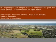
The Copenhagen 1948 Finger plan - a comprehensive plan<br />
for urban growth, infrastructure and open space<br />
The Fingerplan of 1948 was a proposal for <strong>the</strong> general development of Copenhagen. The<br />
plan addressed <strong>the</strong> sectors housing, industry, transport, recreation, supply and disposal.<br />
The iconic front page of <strong>the</strong> Fingerplan indicates its basic idea: <strong>the</strong> palm of <strong>the</strong> hand being<br />
<strong>the</strong> hi<strong>the</strong>rto layer-upon layer developed city whereas <strong>the</strong> fingers constitute <strong>the</strong> future<br />
band-shaped suburbs to be developed along <strong>the</strong> major traffic routes. This pattern plan<br />
should create easy access for <strong>the</strong> suburbanites to <strong>the</strong> commercial and industrial centre,<br />
and provide access to recreational areas in <strong>the</strong> wedges between <strong>the</strong> fingers. The open<br />
space wedges should however also provide farm land, and space for future infrastructure.<br />
In <strong>the</strong> two decades after <strong>the</strong> formulation of <strong>the</strong> Fingerplan, <strong>the</strong> population increase<br />
implied a huge area demand which forced <strong>the</strong> planners to let <strong>the</strong> fingers grow increasingly<br />
thicker and <strong>the</strong> wedges accordingly narrower. Fur<strong>the</strong>r, <strong>the</strong> area demand for each housing<br />
unit and <strong>the</strong> industry area demands grew beyond imagination of <strong>the</strong> 1940s. As a<br />
consequence of <strong>the</strong> growth of <strong>the</strong> city, <strong>the</strong> original mono-centre city was substituted with<br />
a polycentric structure, where each finger has at least one commercial centre of its own.<br />
During this period <strong>the</strong> wedges were under strong pressure. Two of <strong>the</strong> wedges were<br />
safeguarded by planning initiatives in <strong>the</strong> 1960s and 1970s. The third was almost<br />
eliminated. The reason was primarily lack of appropriate planning and legislation.<br />
The industrialization of agriculture and <strong>the</strong> opening of <strong>the</strong> international food markets<br />
eliminated <strong>the</strong> need for production areas close to <strong>the</strong> city, and <strong>the</strong> wedges were<br />
transformed to almost pure recreational areas. The wedges have developed differently,<br />
according to <strong>the</strong> authority in charge.<br />
The development of Copenhagen shows however that <strong>the</strong> basic idea of <strong>the</strong> Fingerplan has<br />
been followed. And according to <strong>the</strong> present 2007 version of <strong>the</strong> Fingerplan, it will be<br />
followed in <strong>the</strong> next decades as well. Several contemporary trends may challenge this<br />
urban pattern however. The climate agenda may suggest a more condense urban pattern<br />
in <strong>the</strong> future due to <strong>the</strong> high transport needs with <strong>the</strong> dispersal of urban areas. The<br />
proximity of urban areas to open space may on <strong>the</strong> o<strong>the</strong>r hand help in climate mitigation.<br />
Open space may offer cooling effects and space for flood water.<br />
The seven decades of Copenhagen planning has proven that a simple guiding principle for<br />
urban growth may be very resistant during changing conditions in society, but that it is<br />
essential that <strong>the</strong> legislation keeps pace with plans and visions.<br />
Page 20 • <strong>Managing</strong> <strong>the</strong> <strong>Urban</strong> <strong>Rural</strong> <strong>Interface</strong> • 19-22 October 2010
Pamela Warhurst<br />
Commander of <strong>the</strong> Order of <strong>the</strong> British Empire,<br />
Chair of <strong>the</strong> Board of Forestry Commissioners, UK<br />
A new generation of partnerships as drivers for regional<br />
development: experience from <strong>the</strong> Greater Manchester<br />
region<br />
The new UK government has taken down much of <strong>the</strong> framework for regional and<br />
strategic planning, with a drive to <strong>the</strong> ‘new local-ism’. This is fine for issues which fit<br />
inside local authority boundaries. But for o<strong>the</strong>r issues, such as urban-rural linkages, ecosystem<br />
services, landscape management, strategic infrastructure, etc, we are now going<br />
through a rapid learning curve. Some in <strong>the</strong> UK look ahead and see only ‘chaos and cuts’:<br />
but <strong>the</strong>re may also be opportunities and alternative ways of making public policy and<br />
investment.<br />
For this <strong>the</strong> PLUREL ‘experience’ has been invaluable. We have exchanged across <strong>the</strong> EU,<br />
matched physical to social science, (started to) link science with policy, and looked at how<br />
to build integrated solutions from a set of parts. It’s fair to say that one of <strong>the</strong> PLUREL<br />
results is that we need ‘more research’, and we hope to continue that in <strong>the</strong> UK. We also<br />
need to continue building some kind of common language, so that different sectors and<br />
disciplines can communicate with policy makers and <strong>the</strong> public, especially to respond to<br />
challenges such as <strong>the</strong> peri-urban which cross so many boundaries.<br />
There is active debate in <strong>the</strong> UK on <strong>the</strong>se issues. ‘The Economics of Ecosystems and<br />
Biodiversity’ (TEEB) is being launched, with a major test case in <strong>the</strong> South Pennines, <strong>the</strong><br />
upland peat-bogs between Leeds and Manchester. The government agency Natural<br />
England has re-opened <strong>the</strong> debate on Green Belts and <strong>the</strong> urban fringe, looking for more<br />
multi-functional, responsive, joined-up policy. The Forestry Commission is looking at<br />
ways to continue <strong>the</strong> <strong>the</strong>me of <strong>the</strong> ‘Community Forests’ which were started not only as a<br />
‘greening’ of post-industrial urban-rural fringes, but as a new model for multi-sectoral<br />
community partnerships. In forestry as with o<strong>the</strong>rs, alternative models of civil<br />
engagement are emerging: not only with local communities, but a whole range of<br />
interests, from landowners and utilities, to education and health, large and small<br />
enterprises, mutual funds or cooperative finances. Various city-regions, when <strong>the</strong><br />
planning system picks up <strong>the</strong> pieces, will be looking at urban-rural links and green-blue<br />
infrastructure, as a way to improve quality of life and economic vitality for both urban and<br />
rural.<br />
It’s also relevant that in <strong>the</strong> UK (of which Manchester is a good cross-section), we have<br />
some experience of managing <strong>the</strong> urban-rural interface, i.e. <strong>the</strong> Green Belt. In some ways<br />
this is all about protecting property values for <strong>the</strong> already affluent. It is generally<br />
successful in containing basic urban growth: but <strong>the</strong>n we find that large parts of <strong>the</strong><br />
countryside have turned urban anyway, in many aspects of economic and social life. The<br />
Green Belt could be (and in some areas is already) not a sterilized no-mans-land, or an<br />
area of horse stables for <strong>the</strong> very wealthy: but ra<strong>the</strong>r a multi-functional, diversified<br />
‘human eco-system’, which provides a wide variety of services both within and to <strong>the</strong><br />
wider area.<br />
So which way to go from here? We need more integrated spatial planning, for multifunctional<br />
landscapes, with better ways of linking with economic factors and social<br />
attitudes, with enhanced public participation and debate. But <strong>the</strong>re are also lessons which<br />
are really beyond public policy. Experiences such as <strong>the</strong> Todmorden Incredible Edible<br />
scheme show <strong>the</strong> potential, if various sections of <strong>the</strong> community start working toge<strong>the</strong>r,<br />
mobilizing huge aspirations and unlocking hidden resources.<br />
Page 21 • <strong>Managing</strong> <strong>the</strong> <strong>Urban</strong> <strong>Rural</strong> <strong>Interface</strong> • 19-22 October 2010
While this is seen to work well in a closely-knit market town surrounded by unique<br />
landscapes, <strong>the</strong> next challenge is to scale upwards and sideways, to o<strong>the</strong>r less favoured<br />
parts of <strong>the</strong> city-region. Such ventures go far beyond what can be delivered top-down, or<br />
with large public funding, which is very unlikely for <strong>the</strong> next few years. They point<br />
towards new ways of mobilizing and generating added value for both urban and rural,<br />
again exploring <strong>the</strong> possibilities in alternative models for civil society.<br />
Page 22 • <strong>Managing</strong> <strong>the</strong> <strong>Urban</strong> <strong>Rural</strong> <strong>Interface</strong> • 19-22 October 2010
Topic 1<br />
<strong>Urban</strong>-<strong>Rural</strong> Regions in a<br />
Globalised World: Driving Forces on<br />
Land Use Change<br />
Page 23 • <strong>Managing</strong> <strong>the</strong> <strong>Urban</strong> <strong>Rural</strong> <strong>Interface</strong> • 19-22 October 2010
Irahim Akgül, Dr. Ayşegül Altınörs Çırak, Instructor Dr. Levent<br />
Ünverdi, Dr. Neriman Yörür<br />
Dokuz Eylul University<br />
The Effects of Capital on Land Use in <strong>Rural</strong> Areas through<br />
<strong>the</strong> Process of Globalization in Turkey- Bursa Cargill Case<br />
After <strong>the</strong> Second World War, rate of urbanization gained speed generally in all countiries,<br />
and in Turkey, as well, and through <strong>the</strong> urbanization process, rapid changes and<br />
transformations arised in <strong>the</strong> surrounding areas of existing cities. After this<br />
transformation, especially in metropolitan cities, fertile agricultural lands in <strong>the</strong> rural<br />
areas nearby <strong>the</strong> urban lands were displaced by urban land uses.<br />
Within <strong>the</strong> globalization process in Turkey, in 2000s, so many changes in land use politics<br />
of rural and urban areas occured with <strong>the</strong> influence of international politics. Lots of legal<br />
arrangements went through and <strong>the</strong> conception of rural and urban planning has changed.<br />
As a result of increasing rate of urbanization surrounding rural areas in big cities merged<br />
into urban development. The globalization and <strong>the</strong> industrialization whereby not only <strong>the</strong><br />
rural-urban fringes influenced, but also, in some cities, as a result of ‘urban sprawl’,<br />
agricultural areas were threatened.<br />
Cargill Agriculture Industry and Trade Inc., among <strong>the</strong> top five in agriculture / food<br />
sector in <strong>the</strong> U.S., went into production of corn processing plant in Bursa Province,<br />
Orhangazi County, Gemic Village, on about 22 hectares firstrate agricultural land, at <strong>the</strong><br />
lakeside of Iznik Lake, in 1997. Cargill selected this location for proximity to raw material,<br />
low land prices and to benefit from urban resources. There has been several legal cases,<br />
started against this plant, established on fertile agricultural land, but <strong>the</strong>y resulted in<br />
incompatible judgements.<br />
However, in 2005, <strong>the</strong> area where <strong>the</strong> corn processing plant located has been declared as<br />
‘Special Industrial Zone’ by <strong>the</strong> Council of Ministers Desicion. In <strong>the</strong> same year, Soil<br />
Conservation and Land Use Law has been accepted by <strong>the</strong> Turkish Parliament; yet <strong>the</strong><br />
clause, states, facilitises established on agricultural lands before this year, are allowed<br />
with <strong>the</strong> condition of paying <strong>the</strong> land cost, has been added. In o<strong>the</strong>r words, by means of<br />
this law, <strong>the</strong> plants on agricultural areas were absolved by civil fine. Initially, <strong>the</strong> Lake<br />
Iznik District 1/25.000 Regional Plan revised as Lake Iznik Environment 1/25.000<br />
Regional Plan Revision, concerning <strong>the</strong> area, included in <strong>the</strong> agricultural areas under<br />
conservatin in <strong>the</strong> Lake Iznik District 1/25.000 Regional Plan. Besides, in 2007, ano<strong>the</strong>r<br />
legal arrangement was regulated, regarding use of productive agricultural lands for nonagricultural<br />
functions.In less developed countries, international capital have started to<br />
choose not around <strong>the</strong> city as site selection, but also in rural areas. Types of land use in<br />
rural areas and physical planning decisions have been changed and used as agricultural<br />
land for urban purposes. In this sense, springing and site selecting in rural areas of urban<br />
land use types can be evaluated as ‘urban fringe’.<br />
This paper aims to highlight <strong>the</strong> effect of land use changes in urban-rural areas and in this<br />
context, aims to show <strong>the</strong> effects of an international company within <strong>the</strong> discourses of<br />
globalization in a less developed country. It will also be showed that how globalization<br />
manipulates legal regulations into its own favor and, how it is an obstacle for urban-rural<br />
land use and sustainability of natural resources in <strong>the</strong>se countries.<br />
As <strong>the</strong> method of research; for current land use for <strong>the</strong> Cargill plant area will be analyzed;<br />
plans for <strong>the</strong> area: landscaping plan, development plan and development plan revision wil<br />
be compared; <strong>the</strong> current land use transform processes and related data will be evaluated;<br />
and for a sustainable urban-rural physical planning ‘what should be done’<br />
(recommendations) will be developed.<br />
Page 24 • <strong>Managing</strong> <strong>the</strong> <strong>Urban</strong> <strong>Rural</strong> <strong>Interface</strong> • 19-22 October 2010
Meliz Akyol, Hayriye Esbah<br />
Istanbul Technical University<br />
Permaculture as a Tool for Sustainability in Cities<br />
Establishing <strong>the</strong> urban rural linkages is a critical endeavor for <strong>the</strong> quality of life in urban<br />
areas. We aim to discuss <strong>the</strong> utility of permaculture principles in peri-urban areas to<br />
promote sustainable communities. We also seek answers to <strong>the</strong> questions: How do we<br />
use permaculture not only in rural but also in core urban areas? Can we recognize energy<br />
efficient designs as emerging concepts for permaculture, and permaculture as a tool for<br />
sustainability?<br />
First, we present underlying forces of urbanization in Turkey as well as demands on land<br />
use and resources. Second, we introduce permaculture and energy efficiency within <strong>the</strong><br />
context of landscape urbanism. This part will be supported by national and international<br />
case studies. And finally, we will develop planning and design recommendations for<br />
sustainable development of rural urban interface.<br />
We believe that designing with permaculture is a sound approach for sustainable future of<br />
our urban environments, and lessons from Turkey’s case can be helpful for o<strong>the</strong>r<br />
developing countries.<br />
Page 25 • <strong>Managing</strong> <strong>the</strong> <strong>Urban</strong> <strong>Rural</strong> <strong>Interface</strong> • 19-22 October 2010
Baptiste Boitier, Pierre Le Mouël, Paul Zagame<br />
Laboratoire ERASME - Ecole Centrale Paris & Université de Paris 1<br />
Possible European futures: 4 scenarios elaborated based<br />
on population; energy price; world economic activity; R&D<br />
investments; and carbon price drivers.<br />
The future is uncertain and not predictable never<strong>the</strong>less <strong>the</strong> anticipation for future is<br />
indispensable to prepare now <strong>the</strong> necessary adaptation to future changes. In this context,<br />
scientists use <strong>the</strong> concept of scenarios in which <strong>the</strong>y try by extrapolation, imagination and<br />
knowledge to predict how might be <strong>the</strong> future. We present four scenarios about possible<br />
futures for European Union and to build <strong>the</strong>m we use scenarios developed for <strong>the</strong><br />
PLUREL project and based on IPCC SRES. The four scenarios are differentiated by <strong>the</strong>ir<br />
respective orientation, ei<strong>the</strong>r towards a global and top-down dynamic or a regional<br />
bottum-up dynamic and ei<strong>the</strong>r towards social and environmental values or private and<br />
economic values. These scenarios are defined in a qualitative manner through storylines<br />
used to quantify main drivers that are implemented, in <strong>the</strong> large applied economic model<br />
NEMESIS, to assess <strong>the</strong> scenarios up to 2025. We concentrate on 5 main drivers: <strong>the</strong><br />
population and its structural evolution that define <strong>the</strong> labor supply and <strong>the</strong>n <strong>the</strong> labor<br />
market equilibrium; <strong>the</strong> energy and particularly oil price that acts on economic activity<br />
through production costs, transportation costs and heating costs; <strong>the</strong> World economic<br />
activity that partially defined <strong>the</strong> economic performance of EU countries through external<br />
trades; R&D investments that, by productivity gains and rise of goods quality, transform<br />
<strong>the</strong> economic activities in EU countries; and finally carbon price constraining <strong>the</strong> fossil<br />
energy uses and pushing up <strong>the</strong> technological development and use of renewable<br />
energies. The NEMESIS model is a detailed macro-econometric model for EU covering 32<br />
production sectors and 27 consumption goods in each EU countries. Comparing to o<strong>the</strong>r<br />
economic models, <strong>the</strong> NEMESIS model has several advantages, it is enough detailed to<br />
take into account structural change in <strong>the</strong> European economies, it is designed to integrate<br />
some aspects of <strong>the</strong> recent endogenous growth <strong>the</strong>ory through R&D investments and<br />
knowledge externalities and it also includes a land-use module that treats land claims<br />
hierarchically and determines a agricultural land use price that reflect <strong>the</strong> land scarcity in<br />
each EU countries. We present and explain in this paper <strong>the</strong> drivers and results of <strong>the</strong><br />
PLUREL scenarios simulations with <strong>the</strong> NEMESIS model.<br />
Page 26 • <strong>Managing</strong> <strong>the</strong> <strong>Urban</strong> <strong>Rural</strong> <strong>Interface</strong> • 19-22 October 2010
Mads Farsø<br />
Danish Center for Forest, Landscape and Planning, University of<br />
Copenhagen<br />
The concept of landscape in landscape(d) urbanism<br />
This paper addresses <strong>the</strong> notion of landscape in recent <strong>the</strong>ory on landscape and<br />
urbanism, especially within <strong>the</strong> fields that sees <strong>the</strong>se as interwoven - e.g. in concepts of<br />
peri-urban landscapes, urban landscapes, urban-rural regions and suburban landscapes.<br />
What is <strong>the</strong> meaning of landscape in this new peri-urban urban-rural landscape<br />
urbanism?<br />
Main question is how <strong>the</strong> concept can be differentiated within <strong>the</strong> positions, fields and<br />
agendas: Is landscape a concept for an object or something subjective? Can it both be a<br />
quantitative and qualitative notion? Is landscape used to illustrate a process or is it only a<br />
metaphor in <strong>the</strong> lack of a better concept for <strong>the</strong> urban? Is landscape used to frame or to<br />
imaging? Does landscape reflect a ‘box’, ‘biotope’ or a ‘network’-thinking? Is landscape<br />
more relational? Is it historic or less historic? Is landscape more ecological in its meaning<br />
than ‘region’? How does landscape actually differ in a debate about <strong>the</strong> regional? Or is it<br />
just all <strong>the</strong> same?<br />
Focus will be on <strong>the</strong> new literature within <strong>the</strong> field landscape urbanism which is a cross<br />
over of landscape architecture, urbanism and urban <strong>the</strong>ory writings. These have grown<br />
out of a demand of a new language for <strong>the</strong> contemporary city that can better relate to<br />
globalised forces that inflict land use change. Some of its key texts state that landscape is<br />
infrastructure. In this context we are experiencing new systems, new flows, new forces,<br />
new powers in <strong>the</strong> urban-rural region. But what could make a landscape instrumental?<br />
What makes it a potential for <strong>the</strong>ory? Is it <strong>the</strong> peri-urban?<br />
Finally, who decides about <strong>the</strong>se new peri-urban ‘landscapes’? The ones who coin it? The<br />
ones who research it? The ones live in it? The ones who imagined it? This is some of <strong>the</strong><br />
topics that this paper will to debate.<br />
Page 27 • <strong>Managing</strong> <strong>the</strong> <strong>Urban</strong> <strong>Rural</strong> <strong>Interface</strong> • 19-22 October 2010
Dagmar Haase, Nadja Kabisch<br />
Helmholtz Centre for Environmental Research - UFZ Department<br />
Computational Landscape Ecology<br />
Diverging European cities – The drivers of urban<br />
population development 1990-2008<br />
A complex mosaic of urban population paths characterizes Europe in <strong>the</strong> 21st century:<br />
cities gaining population exist next to cities loosing population.<br />
In this paper, we identify and show evidence of this population dynamics between 1990<br />
and 2008 using <strong>the</strong> case of more than 200 European cities. To approximate this issue we<br />
applied <strong>the</strong> cyclic quantitative model of <strong>the</strong> stages of urban development. We use <strong>the</strong><br />
model because it relates to different population dynamics of urban growth and decline<br />
and focuses on <strong>the</strong> core city and fringe area which both constitute an urban<br />
agglomeration. As new trends of current European urban development are evolving,<br />
which are assumed not to be reflected by <strong>the</strong> conceptual structure of this model, we<br />
scrutinise its validity against our results. We fur<strong>the</strong>r identify <strong>the</strong> driving forces of<br />
diverging urban population development. In particular, we focus on local pathways and<br />
historical events, but also on different significant drivers of urban trajectories such as<br />
migration, natural increase, and economic fortunes. In addition, we analyse what kind of<br />
influences do have globalisation and <strong>the</strong> demographic change. Finally we quantify <strong>the</strong><br />
impacts of population growth or decline on urban land use change using urban residential<br />
area and housing space per person.<br />
Page 28 • <strong>Managing</strong> <strong>the</strong> <strong>Urban</strong> <strong>Rural</strong> <strong>Interface</strong> • 19-22 October 2010
Anna M. Hersperger, Dominik Langhamer, Thomas Dalang<br />
Swiss Federal Research Institute WSL<br />
Understanding patterns and driving forces of <strong>the</strong> Swiss<br />
periurban landscape through benches, signposts, and a<br />
wealth of o<strong>the</strong>r small objects<br />
The Swiss periurban landscape is interspersed settlements, characterized by many small<br />
objects such as benches, signposts, and fruit stands. This landscape is still hard to grasp,<br />
partly because of <strong>the</strong> lack of appropriate models for periurban land dynamics and partly<br />
because of a lack of data at an appropriately fine scale. Our study is based on a conceptual<br />
model for periurban land dynamics in Switzerland that includes four processes and <strong>the</strong>ir<br />
driving forces. The research goal is threefold: (1) to develop and test a method to<br />
inventory <strong>the</strong> small landscape objects, (2) to describe <strong>the</strong> patterns of small objects in <strong>the</strong><br />
periurban landscape, and (3) to investigate aspects of <strong>the</strong> conceptual model relating to<br />
driving forces and factors indicative for <strong>the</strong> spatial distribution of <strong>the</strong> small objects. We<br />
sampled 47 randomly selected 1 km 2 sampling plots in <strong>the</strong> Canton Aargau, Switzerland. In<br />
<strong>the</strong> sampling plots all objects not included in <strong>the</strong> topographic map but big enough to be<br />
perceived by a pedestrian were recorded. We recorded 1320 observations for 157 objects.<br />
Preliminary analysis shows that 42% of <strong>the</strong> observations can be associated with<br />
recreation, 26% with forestry, 16% with infrastructure, 10% with agriculture and 6% with<br />
o<strong>the</strong>rs. Current investigations indicate that driving forces indicative for <strong>the</strong> spatial<br />
distribution are unique to <strong>the</strong> four processes described in <strong>the</strong> conceptual model and<br />
strongly relate to distance to settlements and topography. The inventory reflects <strong>the</strong><br />
enormous complexity of <strong>the</strong> periurban landscape but allows deepening our understanding<br />
of <strong>the</strong> patterns, processes, and driving forces of <strong>the</strong> periurban landscape.<br />
Page 29 • <strong>Managing</strong> <strong>the</strong> <strong>Urban</strong> <strong>Rural</strong> <strong>Interface</strong> • 19-22 October 2010
Patricia Jacob<br />
Bergische Universität Wuppertal<br />
Casablanca between planning and informal development<br />
Unlike most cities in Western Europe being confronted with a shrinking or stagnating<br />
population, many cities in emerging economies experience a fast population growth. This<br />
development produces a growing demand for building land suitable for housing, offices,<br />
industry and infrastructure. Besides <strong>the</strong> dynamic, ano<strong>the</strong>r important difference is <strong>the</strong> role<br />
of unplanned, informal construction. The procedures for planning and surveying are often<br />
too slow and too expensive to provide sufficient building plots and a part of <strong>the</strong><br />
population is too poor to afford o<strong>the</strong>r forms of housing. The resulting informal<br />
development has an impact on <strong>the</strong> pattern of land use change.<br />
What is <strong>the</strong> role of informal processes, e.g. illegal land subdivisions and pionier land uses<br />
in <strong>the</strong> urbanization of peri-urban space and how does it influence <strong>the</strong> pattern of<br />
urbanization? How is <strong>the</strong> formal and informal production of space connected?<br />
On one hand informal developments partially lead to unhealthy living conditions and<br />
inappropriate building locations e.g. settlements in zones threatened by inundation, but<br />
on <strong>the</strong> o<strong>the</strong>r hand <strong>the</strong>y provide a quick reaction to a market failure and fulfill a demand<br />
that could o<strong>the</strong>rwise not be satisfied.<br />
The drivers of <strong>the</strong> production and transformation of built space are elaborated on <strong>the</strong> case<br />
of Casablanca, Morocco’s economic centre. The focus lies on <strong>the</strong> peri-urban space being<br />
most under pressure in <strong>the</strong> process of land use changes.<br />
Casablanca has passed from 25 000 inhabitants at <strong>the</strong> beginning of <strong>the</strong> 20ies century to 3<br />
Mio only 100 years later and expanded in a concentric way around <strong>the</strong> medina and <strong>the</strong><br />
harbor. The sphere of influence of <strong>the</strong> core city is extending and <strong>the</strong> peri-urban land<br />
assumes functions for <strong>the</strong> urban agglomeration. Disperse settlements gradually change<br />
<strong>the</strong> formally rural character and agricultural use is abandoned due to <strong>the</strong> price that can be<br />
obtained for potential building land. Industrial uses are relocated from inadequate areas<br />
in <strong>the</strong> centre towards <strong>the</strong> periphery, followed by housing both in form of islands of shanty<br />
towns and quarters with economic housing. At <strong>the</strong> same time large satellite towns for<br />
about 300 000 new inhabitants each are planned. Ano<strong>the</strong>r factor influencing <strong>the</strong><br />
accommodation of land uses is <strong>the</strong> possibility to mobilize land for building. This aspect is<br />
closely linked to <strong>the</strong> forms of land tenure existing in Morocco, including different<br />
collective forms and <strong>the</strong> fact that a minority of plots is registered in <strong>the</strong> cadastre.<br />
Page 30 • <strong>Managing</strong> <strong>the</strong> <strong>Urban</strong> <strong>Rural</strong> <strong>Interface</strong> • 19-22 October 2010
Konstantinos Lalenis, Dimitrios Kalergis<br />
University of Thessaly<br />
Spatial Planning Systems in E.U. and North America: still<br />
members of an extended family?<br />
The proposed presentation aims to complement related research conducted as an integral<br />
part of <strong>the</strong> PLUREL project. In PLUREL, a review of EU administrative/governance and<br />
spatial planning systems is prepared, with emphasis on <strong>the</strong> formulation of a typology of<br />
<strong>the</strong>se systems, based on legislation in force in <strong>the</strong> EU nations, national specificities and<br />
planning approaches.<br />
This presentation focuses on <strong>the</strong> spatial planning sector and a main objective of it is to<br />
examine whe<strong>the</strong>r <strong>the</strong> spatial planning systems of Canada and <strong>the</strong> U.S. can be included in<br />
<strong>the</strong> typologies developed for <strong>the</strong> European systems. Historically, <strong>the</strong> North American<br />
planning systems were considered as deriving from <strong>the</strong> Anglo Saxon family of nations’<br />
tradition, although <strong>the</strong> degree of federalization in <strong>the</strong> related government structures<br />
(provinces, states) made <strong>the</strong>m also related to <strong>the</strong> Germanic family. In mid and late ‘90s,<br />
Canada and <strong>the</strong> U.S. were included in research related to families of nations of various<br />
domains (legal, administrative, transport), toge<strong>the</strong>r with European countries. In <strong>the</strong> last<br />
decade, though, related research in Europe seems to focus exclusively on E.U. member<br />
states, driven from a need towards Europeanization of <strong>the</strong> sectors of administration and<br />
spatial planning. (ESPON 2.3.2. & 3.2., Rivolin and Faludi: 2005, Farinos: 2006,<br />
NORDREGIO). Institutional transplantation in planning issues has also been developing<br />
in both sides of <strong>the</strong> Atlantic but not so much between <strong>the</strong> two sides. Never<strong>the</strong>less, interest<br />
in comparative analyses of American and European systems never ceased, and this<br />
research aims to contribute in “bridging” this gap. Globalization has brought countries<br />
very close, and in <strong>the</strong> case of European and North American countries, <strong>the</strong>re is an even<br />
closer cooperation in research and scientific/academic activities. Fur<strong>the</strong>rmore,<br />
equivalence in <strong>the</strong> domain of spatial planning makes institutional transplantation<br />
possible and mutually useful.<br />
The research related to this presentation will examine <strong>the</strong> most recent and well known<br />
typologies of spatial planning systems/styles/concepts at <strong>the</strong> national level, in <strong>the</strong> EU-27<br />
countries and U.S. and Canada, and will attempt to suggest a common typology. This<br />
might serve as a basis for a first level of analysis for <strong>the</strong> equivalent clusters of North<br />
American - EU countries, and a second, more elaborate level for individual countries<br />
representing each cluster. In this way, cross case transfer of results will be possible as well<br />
as <strong>the</strong> generalisation of <strong>the</strong> results and <strong>the</strong>ir inclusion in policy formulation.<br />
Page 31 • <strong>Managing</strong> <strong>the</strong> <strong>Urban</strong> <strong>Rural</strong> <strong>Interface</strong> • 19-22 October 2010
Sophie Schetke¹, Paolo Pileri², Theo Kötter¹, Luca Tomasini²<br />
¹University of Bonn;<br />
²Politecnico di Milano<br />
Counteracting sprawl and land consumption in <strong>the</strong> urbanrural<br />
interface of <strong>the</strong> European agglomerations Milan and<br />
Cologne/Bonn: framework conditions and planning<br />
approaches<br />
In many European countries, patterns of settlement-growth and dynamics of economic<br />
development are discoupled from <strong>the</strong> demographic development. Despite of decreasing<br />
population numbers, urban expansion due to spatial development pressure has been <strong>the</strong><br />
driving force of enormous land consumption, <strong>the</strong> usage of natural resources and <strong>the</strong> loss<br />
of ecosystem services during <strong>the</strong> last years. This paper presents a comparison of two<br />
different geographic areas – <strong>the</strong> region of Milan (Italy) and <strong>the</strong> region of Cologne/Bonn<br />
(Germany). It starts from descriptive basic indicators (land use composition indicators in<br />
two different ages; population dynamics, main economic indicators; etc.) and assesses<br />
associated trends of land use/land consumption/environmental effects in <strong>the</strong>se two<br />
macro regions.<br />
In doing so, this paper is to be understood as an initial starting-point for a pluri-annual<br />
research-cooperation between <strong>the</strong> Politecnico di Milano and <strong>the</strong> University of Bonn. Until<br />
now, political ambitions to reduce land consumption are ei<strong>the</strong>r too weak or ineffective in<br />
both countries. An international comparison can help in accelerating to tackle <strong>the</strong> issue of<br />
land consumption into consideration by <strong>the</strong> international board within <strong>the</strong> EU. Until now,<br />
<strong>the</strong> role of land consumption is too weak and too underconsidered amongst planners and<br />
politicians. Following <strong>the</strong>se issues, <strong>the</strong> paper focuses on three major research-fields:<br />
1. Efficiency of Italian and German planning-instruments to reduce land<br />
consumption<br />
2. Demographic trends and <strong>the</strong>ir impacts on land-consumption and settlementpattern<br />
in Italy and Germany<br />
3. Acceptance of <strong>the</strong> local politicians and <strong>the</strong> society itself of a fostered reduction of<br />
land consumption<br />
Page 32 • <strong>Managing</strong> <strong>the</strong> <strong>Urban</strong> <strong>Rural</strong> <strong>Interface</strong> • 19-22 October 2010
Antti Vasanen<br />
University of Turku / Regional Council of Southwest Finland<br />
The impact of residential preferences on peri-urban<br />
spatial structure in <strong>the</strong> urban region of Turku, Finland<br />
During recent decades, urban regions across developed countries have experienced<br />
considerable changes. The outward shift of population and <strong>the</strong> overall deconcentration of<br />
urban regions have characterised most cities; a trend initiated by <strong>the</strong> development of<br />
public transportation systems and accelerated by private car ownership. More recently,<br />
globalisation, <strong>the</strong> rise of <strong>the</strong> information based economy and changing demographic<br />
composition have dramatically changed <strong>the</strong> structure of urban regions as traditional<br />
monocentric cities have given way to more polycentric urban constellations.<br />
The deconcentration of urban population, whe<strong>the</strong>r resulting in urban sprawl or<br />
polycentric urban development, is a result of a number of different factors. One of <strong>the</strong>se<br />
factors, emphasised in various studies, is residents' preference for a certain type of<br />
dwelling or residential area. In housing research, residential preferences have been<br />
approached in two ways. In <strong>the</strong> first class of studies, residential preferences are<br />
considered to be revealed in individual housing choices. This approach, however, gives an<br />
overly simplified view of residential preferences as <strong>the</strong> choice of dwelling always involves<br />
a number of o<strong>the</strong>r factors, such as dwelling price, travel time to work or local school<br />
quality. In studies applying <strong>the</strong> second approach, respondents are asked to state <strong>the</strong>ir<br />
preference in <strong>the</strong> context of a hypo<strong>the</strong>tical moving situation. This approach can obviously<br />
better answer to <strong>the</strong> question of what type of residence people actually do prefer.<br />
However, <strong>the</strong> relationship between stated preferences and <strong>the</strong> process of housing choice<br />
has rarely been addressed in urban research.<br />
In <strong>the</strong> paper, I concentrate on <strong>the</strong> issues of residential preferences and housing choice<br />
using <strong>the</strong> functional urban region of Turku, Finland, as a case study. Turku urban region<br />
is <strong>the</strong> third largest city region in Finland with over 300,000 inhabitants. The research<br />
problem is twofold. First, I examine what kind of spatial patterns exist in <strong>the</strong> urban region<br />
concerning <strong>the</strong> different factors of housing choice. Second, I deepen <strong>the</strong> analysis through<br />
<strong>the</strong> spatial comparison of <strong>the</strong> central and peri-urban parts of <strong>the</strong> region and address what<br />
factors of housing choice, on <strong>the</strong> one hand, and residential preferences, on <strong>the</strong> o<strong>the</strong>r,<br />
explain <strong>the</strong> decision of residing in different residential environments.<br />
The empirical data of <strong>the</strong> study consist of <strong>the</strong> results of a residential questionnaire, which<br />
included 1,137 respondents from <strong>the</strong> Turku urban region. The data provide geographically<br />
referenced information on <strong>the</strong> respondents' current dwelling choices, (stated) residential<br />
preferences and housing satisfaction. The data are analysed using statistical and GIS<br />
analyses.<br />
Page 33 • <strong>Managing</strong> <strong>the</strong> <strong>Urban</strong> <strong>Rural</strong> <strong>Interface</strong> • 19-22 October 2010
Page 34 • <strong>Managing</strong> <strong>the</strong> <strong>Urban</strong> <strong>Rural</strong> <strong>Interface</strong> • 19-22 October 2010
Topic 2<br />
Scenarios: Futures for <strong>Rural</strong>-<strong>Urban</strong><br />
Regions<br />
Page 35 • <strong>Managing</strong> <strong>the</strong> <strong>Urban</strong> <strong>Rural</strong> <strong>Interface</strong> • 19-22 October 2010
Annette Bauer, Dagmar Haase<br />
Helmholtz Centre for Environmental Research – UFZ<br />
Land use scenarios based on a participative design<br />
How do practitioners and regional stakeholders see land use changes in a rural-urban<br />
region? Which forming conditions are considered essential and how are <strong>the</strong> resultant land<br />
use changes evaluated? What, accordingly, are appropriate steering options? These<br />
questions were tackled between PLUREL researchers and spatial planning practitioners<br />
during a scenario workshop in <strong>the</strong> Leipzig-Halle region in spring 2009. Practitioners<br />
came from diverse sectors of <strong>the</strong> planning administration mainly, such as green space and<br />
infrastructure planning at <strong>the</strong> local and regional level. The workshop thus provided a<br />
cross-sectoral perspective on land use change, though with a clear focus on planning<br />
officials' views.<br />
The scenario workshop was conceptualised to explore future land use patterns for <strong>the</strong><br />
Leipzig-Halle region under diverging assumptions of demographic and economic<br />
development and spatial planning. Based on such assumptions, <strong>the</strong> following starting<br />
points were given: Managed Shrinkage, Uncontrolled Growth and Managed Growth.<br />
Using background data provided by researchers, <strong>the</strong> participants were asked to develop<br />
land use scenarios in three, consecutive stages. First, a spatial vision for <strong>the</strong> year 2025<br />
was created. The resulting maps and land use patterns give a spatial interpretation of <strong>the</strong><br />
basic, quantitative conditions of <strong>the</strong> respective PLUREL models. During <strong>the</strong> second<br />
phase, <strong>the</strong> forming conditions of <strong>the</strong> scenarios were outlined and economic and<br />
demographic drivers as well as <strong>the</strong> role of spatial planning were discussed for each<br />
scenario. Finally, participants acted as members of a "regional council", evaluating <strong>the</strong><br />
social, economic and environmental impacts of <strong>the</strong> scenarios.<br />
This discursive approach enabled scientists to gain a more locally grounded perspective<br />
on land use development. The scenario results, to be presented as spatial visions and<br />
discussion briefs, informed land use modelling in <strong>the</strong> PLUREL project and provided a<br />
focus for <strong>the</strong> analysis of spatial planning in <strong>the</strong> Leipzig-Halle region.<br />
Page 36 • <strong>Managing</strong> <strong>the</strong> <strong>Urban</strong> <strong>Rural</strong> <strong>Interface</strong> • 19-22 October 2010
Beatrice De Carli<br />
Politecnico di Milano<br />
RE: Re-cycle, Re-use, Re-frame<br />
Wave after wave, as <strong>the</strong> modification of <strong>the</strong> territory progresses, whole areas are endlessly<br />
re-processed: lands are abandoned and cleared, <strong>the</strong>y fall vacant or derelict, <strong>the</strong>y are<br />
repossessed and reclaimed. As <strong>the</strong> by-products of such transformations, open spaces<br />
emerge in <strong>the</strong> process which represent a state of “in-betweenness”: a murky condition<br />
dangling between a functionally determined past and <strong>the</strong> open possibility of more<br />
lucrative forms of development. This phenomenon concerns not only single plots of land<br />
isolated within <strong>the</strong> built fabric, or thin parcels laying along infrastructures, but – more<br />
strikingly – equally involves vast fragments of open agricultural land, gradually decaying<br />
as <strong>the</strong>y fall out of <strong>the</strong> logics of industrial productivity.<br />
In <strong>the</strong> absence of <strong>the</strong> will or ability to overcome <strong>the</strong> root causes of <strong>the</strong>ir “decay”,<br />
projections on <strong>the</strong> future of “residual” open spaces are often limited to a small-scale<br />
question of image. Seen in this light, underused, wasted and abandoned lands present a<br />
"problem" – a lack of definition – which can be temporarily fixed by <strong>the</strong> means of<br />
beautification and by minimizing <strong>the</strong> possibilities for unrequested uses.<br />
The paper embraces on <strong>the</strong> contrary a simple hypo<strong>the</strong>sis - <strong>the</strong> “residual as material” for<br />
<strong>the</strong> project – to explore <strong>the</strong> opportunity afforded by <strong>the</strong> re-transcription of residual open<br />
spaces for articulating alternative images of <strong>the</strong> territory on <strong>the</strong> large scale. As a result of<br />
<strong>the</strong>ir capillary yet pervasive presence in urban/rural areas across Europe, in fact, <strong>the</strong>se<br />
underused spaces make a tremendous asset for both <strong>the</strong> spatial and environmental<br />
regeneration of <strong>the</strong> territories where we live in - an asset to be exploited by experimenting<br />
modes, forms and concepts of re-investment alternative to more conventional marketdriven<br />
forms of development.<br />
Starting from a case study in <strong>the</strong> urban region of Milan, Italy, <strong>the</strong> contribution will<br />
develop through a strict sequence of interpretative maps aiming to unlock <strong>the</strong> underlying<br />
logics that generate residual open spaces and to translate it into a series of projective<br />
visions on <strong>the</strong>ir possible re-use – shifting from a design to a large scale perspective and<br />
vice versa. Stressing <strong>the</strong> potential system’s value of residual open spaces, and <strong>the</strong><br />
challenge to constructively make use of it, emphasis will be placed on <strong>the</strong>ir physical<br />
characteristics (frequency and spatial consistency, granularity, connectivity) and on <strong>the</strong>ir<br />
crossed relations with both landscape infrastructures and urban fabrics.<br />
Page 37 • <strong>Managing</strong> <strong>the</strong> <strong>Urban</strong> <strong>Rural</strong> <strong>Interface</strong> • 19-22 October 2010
Francisco Escobar, Sarah Mubareka, Cara Rocha Gomes, Carlo Lavalle<br />
European Commission - Joint Research Centre<br />
A comparative study on future land use scenarios in four<br />
European cities<br />
The MOLAND model has been applied to more than 40 areas of variable size in Europe<br />
covering a total area of more than 50,000 sqkm. A significant number of scientific<br />
publications detailing <strong>the</strong> model, <strong>the</strong> methods involved, issues and different applications<br />
have been produced since its development in 1998.<br />
In <strong>the</strong> context of <strong>the</strong> PLUREL project, MOLAND has been applied to four case studies:<br />
Koper, Leipzig, Montpellier and The Hague. In all four cases a number of storylines,<br />
corresponding to respective adaptations of generic scenarios previously developed in<br />
PLUREL, were developed by stakeholders. This common ground is what allows <strong>the</strong><br />
comparative study presented here. Each case study presents <strong>the</strong>ir own characteristics and<br />
peculiarities but <strong>the</strong> future scenarios of land use produced by MOLAND are result of <strong>the</strong><br />
application of <strong>the</strong>se common generic scenarios.<br />
The main purpose of this paper is <strong>the</strong>n to present shared and divergent trends in land use<br />
dynamics for <strong>the</strong> four case studies which have <strong>the</strong> potential to form <strong>the</strong> basis for ulterior<br />
studies on <strong>the</strong> implications of different policies and settings in <strong>the</strong> strong and rapid<br />
transformation of <strong>the</strong> European territory.<br />
The paper also highlights some issues related to data representation and dissemination<br />
currently affecting most geospatial models including MOLAND. In a first attempt to<br />
overcome such issues, <strong>the</strong> last section of <strong>the</strong> paper offers some representation and<br />
dissemination alternatives based on recent advances in geospatial visualization and<br />
multimedia.<br />
Page 38 • <strong>Managing</strong> <strong>the</strong> <strong>Urban</strong> <strong>Rural</strong> <strong>Interface</strong> • 19-22 October 2010
Michael Heinze¹, Christoph Kasper²<br />
¹Bergische Universität Wuppertal<br />
²Technische Universität Berlin<br />
Grand Casablanca 2025 – new roles for <strong>the</strong> urban-rural<br />
relationship?<br />
Within <strong>the</strong> coming decades Morocco will be faced with an increasing variability of<br />
temperatures and rainfall, leading to droughts, floods and rising health problems due to<br />
heat stress. Focusing on Casablanca, Moroccans megacity of tomorrow, as an innovation<br />
nucleus for <strong>the</strong> whole region, <strong>the</strong> initiated scenario process within <strong>the</strong> project “<strong>Urban</strong><br />
agriculture as an integrated factor of climate optimized urban development, Casablanca”<br />
aims to explore <strong>the</strong> perspectives of urban agriculture in supporting urban growth centres<br />
and <strong>the</strong> surrounding peri-urban areas to adapt to <strong>the</strong> prospective climatic conditions and<br />
to mitigate <strong>the</strong> consequences of climate change.<br />
Scenario methodology – specifics of <strong>the</strong> chosen approach<br />
Developed mainly for military purposes in <strong>the</strong> 1970ths <strong>the</strong> scenario methodology has<br />
since <strong>the</strong>n only been slightly modified. Whereas since <strong>the</strong> beginning of <strong>the</strong> 1980ths <strong>the</strong><br />
methodology was frequently used for civilian uses in <strong>the</strong> USA and Europe its usage in<br />
urban planning processes in <strong>the</strong> African world is still a novelty.<br />
The Casablanca region is facing a highly dynamic urban development, affected by<br />
interwoven informal and formal elements, pressurising <strong>the</strong> agricultural land use in <strong>the</strong><br />
peri-urban areas. In light of <strong>the</strong> complex functional relations and impetuses within <strong>the</strong><br />
urban netting that need to be analysed <strong>the</strong> scenario methodology was utilised as it<br />
appears “to be <strong>the</strong> methodology of choice, if discontinuities and uncertainties of any kind<br />
are to be considered with insufficient or predominantly qualitative information in<br />
planning processes“(Schwarz 1993).<br />
Based on a common vision developed during <strong>the</strong> initial phase of <strong>the</strong> project, <strong>the</strong> binational<br />
project team identified <strong>the</strong> key factors influencing <strong>the</strong> possible future<br />
developments of Casablanca. In order to make use of <strong>the</strong> cognition capacity and <strong>the</strong><br />
specific methodical instruments of <strong>the</strong> different disciplinary teams <strong>the</strong> chosen<br />
deconstruction / construction approach developed sectoral alternative scenarios that<br />
were subsequently blended into two all encompassing interdisciplinary scenarios.<br />
Synergies and conflicts in <strong>the</strong> urban and peri-urban space – intermediary results<br />
As an intermediary result, <strong>the</strong> blending of <strong>the</strong> sectoral scenario layers (water, energy,<br />
climate, food security, urban economy etc.) and <strong>the</strong> first attempts to spatialise <strong>the</strong> drawn<br />
conclusion allow to identify potential areas of synergy and conflict with regards to <strong>the</strong><br />
following questions:<br />
How and where can urban agriculture coexist with o<strong>the</strong>r apparently more profitable land<br />
uses?<br />
To what extent can urban agriculture act as a provider of eco system services for <strong>the</strong> city?<br />
To what extent can <strong>the</strong> urban population, by generating a substantial demand for regional<br />
agricultural products and services, contribute to <strong>the</strong> stabilisation and improvement of<br />
living conditions in urban-rural areas?<br />
Page 39 • <strong>Managing</strong> <strong>the</strong> <strong>Urban</strong> <strong>Rural</strong> <strong>Interface</strong> • 19-22 October 2010
Sophie Rickebusch, Corentin Fontaine, Mark Rounsevell<br />
School of GeoSciences, University of Edinburgh, United Kingdom<br />
Regional urban growth in four land-use change scenarios:<br />
a comparative analysis of <strong>the</strong> PLUREL case study regions<br />
<strong>Urban</strong> land-use is generally increasing in Europe and this can be expected to continue in<br />
<strong>the</strong> coming decades. However, <strong>the</strong> intensity and patterns of urbanisation may vary<br />
depending on factors such as demography, transport mode preference or planning policy.<br />
Scenarios represent various combinations of <strong>the</strong>se factors. This allows us to explore<br />
possible futures and <strong>the</strong>ir consequences on processes such as urbanisation. Here, we used<br />
four scenarios to study <strong>the</strong> potential patterns of urbanisation in six European<br />
cities/regions: Haaglanden, Koper, Leipzig, Manchester, Montpellier and Warsaw.<br />
We obtained projections of <strong>the</strong> proportion of artificial surfaces for 2025 in Europe on a 1 x<br />
1 km grid, by means of <strong>the</strong> regional urban growth model (RUG). This model uses regional<br />
projections of urban land-use, derived from projected gross domestic product (GDP) and<br />
population values, and distributes <strong>the</strong>m spatially according to household location<br />
preferences and planning constraints. Household preferences are based on variables such<br />
as travel time cost to <strong>the</strong> nearest city or distance to <strong>the</strong> coast, while planning constraints<br />
use variables such as <strong>the</strong> presence of flood-risk zones. The scenarios determine <strong>the</strong><br />
parameter values for <strong>the</strong> equations relating <strong>the</strong> input variables and <strong>the</strong> household location<br />
preference or <strong>the</strong> planning constraints. Some input variables (e.g. travel time costs) are<br />
also modified by <strong>the</strong> scenarios, while o<strong>the</strong>rs (e.g. distance to <strong>the</strong> coast) are not. From <strong>the</strong><br />
European projections, we extracted <strong>the</strong> data for <strong>the</strong> six case study areas to compare <strong>the</strong><br />
patterns of urban growth and <strong>the</strong> influence of <strong>the</strong> scenarios on each area.<br />
Although <strong>the</strong> same scenarios were applied to each case study area, <strong>the</strong> resulting patterns<br />
of change differ and some regions appear more sensitive to <strong>the</strong> scenarios than o<strong>the</strong>rs. For<br />
instance, Montpellier shows very different patterns of urban growth depending on <strong>the</strong><br />
scenario. On <strong>the</strong> o<strong>the</strong>r hand, Manchester shows very little growth overall, while Warsaw<br />
has high growth in all scenarios, with less distinct patterns than Montpellier. This is<br />
partly due to regional differences in <strong>the</strong> population and GDP projections used as input to<br />
<strong>the</strong> model, with some regions expected to grow far more than o<strong>the</strong>rs. Ano<strong>the</strong>r factor is <strong>the</strong><br />
current level of urbanisation of each case study area. These results show how <strong>the</strong> different<br />
planning policies in <strong>the</strong> scenarios might influence future land-use patterns. They also<br />
highlight regional differences in terms of sensitivity to <strong>the</strong> factors included in <strong>the</strong><br />
scenarios.<br />
Page 40 • <strong>Managing</strong> <strong>the</strong> <strong>Urban</strong> <strong>Rural</strong> <strong>Interface</strong> • 19-22 October 2010
Vegard Skirbekk, Nikola Sander<br />
IIASA<br />
Prospects for later-life migration in urban Europe<br />
The need for more accurate forecasts of future migration flows has increased with <strong>the</strong><br />
relative importance of migration vis-à-vis o<strong>the</strong>r components of population dynamics.<br />
Although forced international migration has been given considerable research attention<br />
in recent years, also o<strong>the</strong>r migration types, in particular later-life migration, become<br />
increasingly important. In <strong>the</strong> coming decade, <strong>the</strong> large baby boom generation will reach<br />
retirement age. The objective of this report is to focus on <strong>the</strong> effects of an ageing<br />
population in terms of urban development and retirement migration. The report<br />
discusses <strong>the</strong> regional population projections and its social impacts. An analysis on <strong>the</strong><br />
impacts of urbanization and differential ageing across regions will be given.<br />
Page 41 • <strong>Managing</strong> <strong>the</strong> <strong>Urban</strong> <strong>Rural</strong> <strong>Interface</strong> • 19-22 October 2010
Brendan Williams¹, Harutyun Shahumyan¹, Laura Petrov², Sheila<br />
Convery¹<br />
¹UCD <strong>Urban</strong> Institute Ireland<br />
²DG - EUROSTAT<br />
European <strong>Urban</strong>-<strong>Rural</strong> Regions – A Scenario Assessment<br />
Tool for Decision Making; Case Study, Greater Dublin<br />
Region 2026<br />
Europe’s urban-rural regions attract growing attention as rapid changes in land use are<br />
expected due to changes in demography, economic developments and technology,<br />
environmental changes and <strong>the</strong> enlargement of <strong>the</strong> European Union. It is of increasing<br />
concern to decision makers, planners and <strong>the</strong> public, that <strong>the</strong> way our urban, rural and<br />
urban-rural areas are functioning may not be sustainable in <strong>the</strong> long term. For example,<br />
Ireland’s population growth was five times <strong>the</strong> European average of 3.25% between 1996<br />
and 2006. The counties within <strong>the</strong> Greater Dublin Region (GDR) experienced <strong>the</strong> biggest<br />
growth nationally with an increase of 8.3% between 2002 and 2006 (CSO, 2007).<br />
Dynamic land use models provide a spatial illustration of alternative development<br />
patterns and trends; <strong>the</strong>y offer a basis for <strong>the</strong> analysis of <strong>the</strong> spatial implications of<br />
particular policies and <strong>the</strong> interactions of multiple planning actions. Additionally,<br />
developing alternative land-development scenarios brings an interesting platform for<br />
discussion when implementing urban-rural scenario policy reforms.<br />
Using <strong>the</strong> GDR as an example (EEA, 2006), we applied <strong>the</strong> MOLAND model to simulate<br />
two future scenarios of settlement patterns by 2026:<br />
Scenario 1: Dispersed development. In this scenario economic growth is observed due to<br />
increase of business activities, agricultural production and <strong>the</strong> service sector. New<br />
constructions are encouraged in <strong>the</strong> rural hinterland. Improvement of regional and local<br />
roads is implemented; <strong>the</strong> Dublin-Belfast transport corridor is encouraged. The scenario<br />
includes a low environmental protection policy.<br />
Scenario 2: Compact development. Increased job numbers observed in industry,<br />
commerce and services making <strong>the</strong>m about 30% more than in Scenario 1. Polycentric<br />
urban agglomeration associated with <strong>the</strong> conservation of existing buildings. New<br />
residential developments take place inside of <strong>the</strong> city, reducing average distance of travel<br />
to work. Public transport is encouraged; new transportation infrastructure and<br />
complementary measures are also introduced. A strong environmental protection policy<br />
is encouraged.<br />
The results are discussed in terms of <strong>the</strong> implications of future settlement patterns for<br />
urban-rural regions. Within <strong>the</strong> GDR <strong>the</strong> residential dense class is dominant in Dublin<br />
County (63.8%), while <strong>the</strong> residential sparse class is dominant in Kildare County (26.4%).<br />
Industrial developments and commercial areas are <strong>the</strong> highest for <strong>the</strong> compact scenario,<br />
particularly in Dublin County.<br />
Reference<br />
1. European Environmental Agency (EEA), 2006. <strong>Urban</strong> sprawl in Europe, The ignored<br />
challenge. Uhel, R. (Ed.), Copenhagen.<br />
2. Central Statistics Office (CSO), 2007. Census 2006, Dublin.<br />
Page 42 • <strong>Managing</strong> <strong>the</strong> <strong>Urban</strong> <strong>Rural</strong> <strong>Interface</strong> • 19-22 October 2010
Topic 3<br />
Land-Use Relationships and <strong>the</strong><br />
Structure of <strong>the</strong> <strong>Rural</strong>-<strong>Urban</strong><br />
System: European and Regional<br />
Models<br />
Page 43 • <strong>Managing</strong> <strong>the</strong> <strong>Urban</strong> <strong>Rural</strong> <strong>Interface</strong> • 19-22 October 2010
Lena Hallin-Pihlatie<br />
Finnish Environment Institute<br />
Exploring and simulating land-use patterns in <strong>the</strong> urbanrural<br />
interface<br />
In this research, <strong>the</strong> expansion of land-use cells occupied by residential, service or<br />
industry buildings was studied. In addition, we attempted to reproduce <strong>the</strong> observed<br />
land-use pattern using <strong>the</strong> LUCIA land-use modeling framework (Hansen 2007).<br />
The study area is a predominantly rural area, where <strong>the</strong>re <strong>the</strong> total population has<br />
increased by 14169 persons, from 455135 to 46930, during a nine-year period, between<br />
<strong>the</strong> years 2000 and 2008. The study area comprises thirty nine municipalities of which<br />
<strong>the</strong> majority (29) suffered from a decline in population. As a contrast, in <strong>the</strong><br />
municipalities affected by <strong>the</strong> economic up-swing of <strong>the</strong> city of Oulu, <strong>the</strong> growth rate in<br />
population were one of <strong>the</strong> highest in Finland for <strong>the</strong> last decade. For example <strong>the</strong><br />
population of Liminka has increased by 49,5% from 5735 in year 2000 to 8576 in year<br />
2008.<br />
To support <strong>the</strong> study, raster layers representing <strong>the</strong> built-up cells in <strong>the</strong> years 2000,<br />
2002, 2005, 2007 and 2008 were produced. The built-up cells were divided into<br />
residential, service and industry cells using data in a 250 meter resolution from <strong>the</strong><br />
Monitoring System of <strong>Urban</strong> Structure (YKR). These data sets were combined with<br />
National Corine Land Cover 2000 data of <strong>the</strong> same resolution.<br />
The spatial pattern of <strong>the</strong> new built-up cells was analysed to explore <strong>the</strong> factors behind<br />
<strong>the</strong> expansion of <strong>the</strong> built-up land-use. It seemed that, new residential cells have emerged<br />
in a scattered manner in <strong>the</strong> whole study area, despite in land areas reserved by Natura<br />
2000 sites. However, <strong>the</strong> proximity to <strong>the</strong> existing urban structure and to <strong>the</strong> road<br />
network seems to have had an effect on <strong>the</strong> placement of new built-up cells. Therefore <strong>the</strong><br />
expansion of new built-up cells was most evident in peri-urban areas.<br />
The pattern of new built-up cells was simulated using <strong>the</strong> LUCIA land-use modeling<br />
framework (Hansen 2007). The scattered pattern of new built cells could to some extent<br />
be reproduced. In order to reproduce <strong>the</strong> observed land-use pattern, it was crucial to<br />
include <strong>the</strong> use of a random factor and to exclude <strong>the</strong> use of a layer of planned zones,<br />
when running <strong>the</strong> model.<br />
Hansen, Henning Sten (2007). An Adaptive Land-use Simulation Model for Integrated<br />
Coastal Zone Planning. In: Lecture Notes in Geoinformation and Cartography. The<br />
European Information Society. Springer. Pages 35-53.<br />
Page 44 • <strong>Managing</strong> <strong>the</strong> <strong>Urban</strong> <strong>Rural</strong> <strong>Interface</strong> • 19-22 October 2010
Piotr Korcelli, Elżbieta Kozubek<br />
Stanisław Leszczycki Institute of Geography and Spatial Organization,<br />
Polish Academy of Sciences<br />
Interrelations between economic and population change<br />
and land use patterns in European rural–urban regions<br />
The paper focuses on <strong>the</strong> evolving structure of <strong>the</strong> European urban and rural<br />
settlement system. PLUREL contributions to <strong>the</strong> study of economic – population – land<br />
use relationships are confronted with findings of o<strong>the</strong>r relevant applied research projects,<br />
such as <strong>the</strong> ESPON programme. Data used in <strong>the</strong> analysis, for NUTS-3 and NUTS-X<br />
units, cover some 20 variables pertaining to, among o<strong>the</strong>rs, population and GDP<br />
dynamics, occupational activity level, proportion of population in working age,<br />
employment by sector, spatial accessibility.<br />
Several hypo<strong>the</strong>ses are tested concerning <strong>the</strong> differentiation of land use relationships<br />
among rural – urban regions. Attempts are made to find out to what an extent <strong>the</strong><br />
observed variations can be attributed to size of <strong>the</strong> regions, <strong>the</strong>ir functional, as well as<br />
morphological types (according to <strong>the</strong> PLUREL RUR typology), <strong>the</strong>ir territorial position<br />
(as measured by accessibility level, connectivity within <strong>the</strong> system, as well as population<br />
potential), and to <strong>the</strong>ir situation in one of <strong>the</strong> major sub-continental divisions, such as<br />
North-West Europe, <strong>the</strong> Baltic Sea region, <strong>the</strong> Mediterranean region, etc.<br />
As it is found out, while <strong>the</strong> large metropolitan areas across Europe tend to display<br />
increasingly similar economic, demographic and land use characteristics, differences<br />
among <strong>the</strong> predominantly rural regions remain quite profound. A question addressed<br />
here is in what measure are <strong>the</strong>se disparities attributable to <strong>the</strong> differentiation of rural<br />
areas (as defined in policy – related studies) into: (a) <strong>the</strong>se situated in proximity of large<br />
urban centres, (b) those with an interspersed network of smaller towns, and (c) <strong>the</strong><br />
remote, peripheral rural areas.<br />
Page 45 • <strong>Managing</strong> <strong>the</strong> <strong>Urban</strong> <strong>Rural</strong> <strong>Interface</strong> • 19-22 October 2010
Sarah Mubareka, Carlo Lavalle, Christine Estreguil<br />
European Commission - Joint Research Centre<br />
<strong>Urban</strong> Compactness: Measures, drivers and barriers: a<br />
land use modelling perspective<br />
Forecasting scenarios using land use models can provide insight into answering <strong>the</strong> “what<br />
if?” questions for <strong>the</strong> future in order to assess which scenario is most beneficial from a<br />
given perspective. The urban perspective is taken in this research with two specific<br />
objectives: 1. To derive a robust approach for assessing <strong>the</strong> impact of different policy<br />
alternatives on urban compactness; and 2. To understand what mechanisms encourage<br />
and discourage urban compactness from a modelling perspective. In order to tackle <strong>the</strong>se<br />
objectives, two baseline scenarios and five hypo<strong>the</strong>tical policy alternatives are run from<br />
2000 to 2030 using <strong>the</strong> pan-European EuClueScanner 1km resolution land use model.<br />
The results are analysed for urban compactness on <strong>the</strong> 305 Large urban zones (LUZ)<br />
provided by <strong>the</strong> <strong>Urban</strong> Audit, an initiative by <strong>the</strong> DG for Regional Policy.<br />
<strong>Urban</strong> morphological patterns are quantified and translated into individual indicators<br />
describing <strong>the</strong> urban expansion patterns (fringe, ribbon development, compactness,<br />
leapfrogging) as well as <strong>the</strong> appearance of new urban core areas and connectors. A<br />
composite indicator for urban compactness is <strong>the</strong>n derived using <strong>the</strong> individual indicators<br />
from <strong>the</strong> 305 LUZ dataset.<br />
The ma<strong>the</strong>matically derived composite indicator for urban compactness is <strong>the</strong>n examined<br />
in fur<strong>the</strong>r detail in order to better understand what factors encourage and discourage<br />
compactness from a modelling perspective. A data sample corresponding to roughly 10%<br />
of <strong>the</strong> entire dataset is taken based on <strong>the</strong> “hot spots” for urban growth, a tool embedded<br />
within <strong>the</strong> EuClueScanner 1km model. The sample represents hot spots that are common<br />
to both scenario baselines and <strong>the</strong>ir policy alternatives.<br />
Results show that <strong>the</strong> impacts of policy alternatives are not only felt at different degrees<br />
for different LUZ, but impacts are often contradictory. Fur<strong>the</strong>r analysis shows that <strong>the</strong><br />
hot spot LUZs are not linked by country, and thus by <strong>the</strong> demand module and o<strong>the</strong>r<br />
national-level parameters such as allocation and neighbourhood rules; but ra<strong>the</strong>r by<br />
landscape composition in and near <strong>the</strong> LUZ. This occurs to such a strong degree that <strong>the</strong><br />
landscape patterns near urban areas can be reclassified according to a “vulnerability”<br />
scale for urban transition and urban form.<br />
Page 46 • <strong>Managing</strong> <strong>the</strong> <strong>Urban</strong> <strong>Rural</strong> <strong>Interface</strong> • 19-22 October 2010
Dave Murray-Rust, Verena Rieser, Mark Rounsevell<br />
University of Edinburgh, United Kingdom<br />
Agent-Based Models for simulating peri-urban Land Use<br />
Relationships: A Proof-of-Concept Study<br />
Agent-Based Modelling (ABM) has successfully been applied to study complex socialeconomic<br />
relationships such as <strong>the</strong> evolution of society (e.g. Kohler and Gumerman<br />
2000), economic systems (e.g. Axtell et al. 2002) and new agricultural practices (e.g.<br />
Parker et al. 2003).<br />
We apply ABM to investigate <strong>the</strong> complex interrelationships between heterogeneous<br />
actors to understand land use and land cover change in <strong>the</strong> peri-urban area, as also<br />
previously investigated by (e.g. van der Veen and Rotmans 2001; Parker et al. 2003;<br />
Huigen 2004; Evans and Kelley 2004).<br />
One key innovation of <strong>the</strong> use of ABM in PLUREL is that <strong>the</strong> relationship between policy<br />
and planning processes within <strong>the</strong> modelled system is made endogenous. This means that<br />
<strong>the</strong> simulated, future evolution of land use (scenario based) will result in policy<br />
responses that guide <strong>the</strong> evolving urban development in a certain direction.<br />
We <strong>the</strong>refore conduct a proof-of-concept study to systematically explore <strong>the</strong> sensitivity of<br />
<strong>the</strong>se models to different parameter<br />
settings and modelling techniques and inform stakeholders and policy makers about<br />
<strong>the</strong>se complex relationships.<br />
We present a generic framework including agents representing Land Use Planning<br />
decision making, Land Use developers, businesses, demographics and residents, as well<br />
as pressure groups that seek to limit or encourage urban development. This framework is<br />
applied to a syn<strong>the</strong>tic case study area, which has simplified versions of <strong>the</strong> structures and<br />
mechanisms found in real life.<br />
In future work we will validate <strong>the</strong> models by setting up <strong>the</strong> framework to simulate<br />
different case studies, including Koper and Manchester.<br />
Page 47 • <strong>Managing</strong> <strong>the</strong> <strong>Urban</strong> <strong>Rural</strong> <strong>Interface</strong> • 19-22 October 2010
Annette Piorr¹, Ingo Zasada¹, Regine Berges¹, Wolfgang Loibl², Piotr<br />
Korcelli 3 , Ivan Tosics 4 , Kostas Lalenis 5 , Susana Alves 6<br />
¹Leibniz-Centre for Agricultural Landscape Research<br />
²Austrian Institute of Technology<br />
3<br />
Polish Academy of Science<br />
4<br />
Metropolitan Research Institute<br />
5<br />
University of Thessaly<br />
6<br />
Edinburgh College of Art<br />
Land Use Change and Sustainability Performance of<br />
European Region Types<br />
<strong>Urban</strong>isation is considered as a major process of land use change. Construction activities<br />
for housing, industry, trade, services and infrastructure lead to loss of open spaces,<br />
formerly used for agriculture, horticulture or recreation. Undisturbed soils become<br />
sealed, population density and traffic increases. <strong>Urban</strong>isation is, however, expected to<br />
induce negative environmental effects: on landscape aes<strong>the</strong>tics and landscape functions,<br />
such as regulation function, habitat value, biodiversity, but also on <strong>the</strong> agricultural<br />
production capacity itself. On <strong>the</strong> o<strong>the</strong>r hand, land use change in <strong>the</strong> peri-urban is linked<br />
to economic growth and increasing welfare in terms of working places, housing near to<br />
nature, reduction of individual traffic, are some of <strong>the</strong> reasons why e.g. young families<br />
move from town to <strong>the</strong> urban fringes.<br />
Though <strong>the</strong> normative expectation proves correct in many cases, it is undeniable that an<br />
analysis of <strong>the</strong> relationship between land use changes due to urbanisation and <strong>the</strong>ir<br />
sustainability impact requires an in depth analysis that takes <strong>the</strong> diversity of conditions<br />
within Europe into account.<br />
Developing a quantitative modelling approach at NUTSX scale, research in PLUREL<br />
made such an effort. The PLUREL integrated Impact Analysis Tool (iIAT) conjoins<br />
assessment results of positive and negative land use change impacts. The iIAT represents<br />
a meta-model that comprises normalised values of underlying regression models<br />
(‘response functions’) into common result presentation in form of spidergrams. Beyond<br />
single NUTSX and NUTS0 regions, it is possible to compare groups of similar regions,<br />
based on typologies. Typologies with reference to urbanisation processes act as a data<br />
aggregation mechanism.<br />
Examples presented are regions with different innovation trends or sensitivity to natural<br />
or technological hazards. Two generic typologies that have been developed within<br />
PLUREL are <strong>the</strong> typology of migration types and land use change (Bell and Alves, 2009)<br />
and a typology of planning policy and governance system (Tosics et al. 2009).<br />
Though <strong>the</strong> application of typologies is meaningful in this context, it also may lead to<br />
biased assumptions and to misinterpretations of results. In order to better assess <strong>the</strong><br />
reliability of <strong>the</strong> PLUREL iIAT results at EU scale we carried out a statistical analysis of<br />
typology based data aggregation.<br />
This paper presents <strong>the</strong> attempt to apply different statistical methods (e.g. multivariate<br />
analysis, clustering) to analyse <strong>the</strong> strength of <strong>the</strong> different typologies used and <strong>the</strong><br />
explanatory value of different selected sustainability indicators.<br />
Page 48 • <strong>Managing</strong> <strong>the</strong> <strong>Urban</strong> <strong>Rural</strong> <strong>Interface</strong> • 19-22 October 2010
Mika Ristimäki¹, Panu Kontio¹, Thomas Sick Nielsen², Ville Helminen¹<br />
¹Finnish Environment Institute<br />
²University of Copenhagen<br />
Interaction between urban and peri-urban: <strong>the</strong> case of<br />
commuting<br />
Commuting is a good measure of urban structure because it links <strong>the</strong> distribution<br />
patterns of economical activities and settlement with transport. In rural-to-urban regions<br />
commuting reflects <strong>the</strong> interaction between urban and peri-urban areas. At <strong>the</strong> regional<br />
level <strong>the</strong> direction of major commuting flows is closely interlinked with urban structure.<br />
The structure of economic agglomerations defines <strong>the</strong> destinations of major commuting<br />
flows. Density, and <strong>the</strong> fragmentation of <strong>the</strong> settlement structure, influences <strong>the</strong><br />
commuting distances. Transport systems facilitate <strong>the</strong> mobility between <strong>the</strong> origin and<br />
destination.<br />
In this study we recognize <strong>the</strong> major commuting patterns taking place in contemporary<br />
urban areas. We use empirical commuting data to illustrate and model <strong>the</strong> interaction<br />
between <strong>the</strong> urban core and <strong>the</strong> surrounding functional region in different urban<br />
structures. Monocentric and polycentric urban forms differ considerably in terms of<br />
commuting patterns. In a monocentric urban form, urban density and distance to <strong>the</strong><br />
centre are interlinked. These are also <strong>the</strong> dominant factors affecting commuting distance.<br />
In a polycentric structure, <strong>the</strong>re are competing employment clusters within travel range,<br />
and thus <strong>the</strong> commuting patterns may vary more.<br />
First <strong>the</strong> focus is on gravity functions of urban areas. The available origin-destination data<br />
on commuting enables <strong>the</strong> study of <strong>the</strong> attractiveness of <strong>the</strong> urban centre. Density<br />
gradients have been a common approach when estimating decentralization processes with<br />
monocentric models. In <strong>the</strong> analysis <strong>the</strong> gradient approach is applied to measure <strong>the</strong><br />
commuting pattern originating from surrounding areas towards <strong>the</strong> centre.<br />
Second part concentrates on commuting patterns in polycentric regions. Increasing travel<br />
range combined with a dense urban system induces functional polycentricicity in many<br />
European regions. However, <strong>the</strong> travel and commuting impacts of this developing<br />
situation has rarely been analysed on its own. The paper focuses on <strong>the</strong> structuring of<br />
commuting patterns of polycentric regions by means of mapping of interaction patterns,<br />
as well as comparisons of urban systems and commuting systems within three case study<br />
regions: Leipzig-Halle, Montpellier and Greater Manchester.<br />
Finally we focus on dynamics of peri-urban commuting. Changes in <strong>the</strong> urban structure<br />
are particularly clear in <strong>the</strong> periphery of <strong>the</strong> cities. New patterns of settlement and<br />
employment require new patterns of mobility and transport. This study discusses <strong>the</strong><br />
impacts of some general trends on peri-urban commuting. These trends include<br />
urbanization, increasing mobility, changes in accessibility, changes in employment<br />
patterns etc.<br />
Page 49 • <strong>Managing</strong> <strong>the</strong> <strong>Urban</strong> <strong>Rural</strong> <strong>Interface</strong> • 19-22 October 2010
Luca Salvati, Sofia Bajocco<br />
CRA-CMA, Rome<br />
Land Use Changes and <strong>the</strong> Mediterranean City – <strong>Urban</strong><br />
Ecology face to face <strong>Urban</strong> Geography: A preliminary<br />
contribution<br />
From <strong>the</strong> morphological point of view, several Mediterranean cities underwent rapid<br />
changes in <strong>the</strong> last century. Demographic dynamics transformed <strong>the</strong> impressive growth of<br />
<strong>the</strong> post-industrial period into <strong>the</strong> recent phase of deconcentration observed in many city<br />
centers followed by a spectacular spillover across <strong>the</strong> city region. The spatial organization<br />
of cities passed as well from <strong>the</strong> traditional compact model to a more dispersed urban<br />
form. This paper deals with this transition and its relationship with land use changes<br />
(LUCs) along <strong>the</strong> urban-rural gradient in two regions taken as paradigmatic examples of<br />
land use dynamics in compact mono-centric and poly-nucleated Mediterranean cities.<br />
LUCs occurred during 1960-2000 in Attica, Greece, and Rome province, Italy, were<br />
assessed by <strong>the</strong> analysis of long-term data at <strong>the</strong> municipal level and compared with<br />
information obtained from additional statistical sources. Changes in six basic land use<br />
categories (agriculture, pasture, forest, water, urban, and o<strong>the</strong>r uses) were explored<br />
diachronically by non-parametric correlation. Results put in evidence <strong>the</strong> impressive<br />
LUCs observed in <strong>the</strong> two regions since 1960. The analysis suggests that a substantial<br />
similarity in LUCs rate can be observed in Rome and A<strong>the</strong>ns. Different patterns of LUCs<br />
were interpreted as driven by <strong>the</strong> traditional socio-economic and institutional drivers,<br />
and <strong>the</strong> contrasting geographical settings. The paper shows how comparative, diachronic<br />
analyses are particularly interesting when debating on <strong>the</strong> Mediterranean city and its<br />
socio-environmental relations with <strong>the</strong> surrounding territory. Environmental<br />
implications of both <strong>the</strong> ‘compact’ and ‘dispersed’ urban growth during 1960-1980 and<br />
<strong>the</strong> rapid urban spillover during 1980-2000 were explored. Prescriptions suitable to<br />
mitigate land fragmentation in environmental sensitive areas were finally discussed.<br />
Page 50 • <strong>Managing</strong> <strong>the</strong> <strong>Urban</strong> <strong>Rural</strong> <strong>Interface</strong> • 19-22 October 2010
Hedwig Van Delden¹, Garry McDonald², Jasper Van Vliet¹<br />
¹Research Institute for Knowledge Systems<br />
²Market Economics Ltd<br />
Choosing agent types for a spatial decision support<br />
system for Auckland city<br />
Spatial models are frequently used as decision support systems, tools to explore possible<br />
future developments of a city, region or country. Since <strong>the</strong>se developments are driven by<br />
human action and interaction, Agent-Based (AB) approaches are a logical choice for<br />
simulating <strong>the</strong>se processes, as agents are a very natural representation of actors that<br />
make decisions. However, it quickly becomes clear that <strong>the</strong> definition of agent-based in<br />
spatial modelling is broad and varies in <strong>the</strong> way decision-making bodies are perceived<br />
and represented in <strong>the</strong> model.<br />
By some, cellular automata (CA) are considered AB models. They are by now commonly<br />
applied to address land use changes, and urban growth in particular. In CA models a<br />
location, represented by a cell, is considered <strong>the</strong> decision making unit, hence <strong>the</strong> agent.<br />
Recently, CA models have been expanded with more detailed information on <strong>the</strong> activities<br />
that are taking place on a location, such as its number of inhabitants, or <strong>the</strong> number of<br />
jobs. This addition to <strong>the</strong> CA framework is named Activity-Based modelling. This<br />
approach allows for incorporation of human behaviour, but agents are not yet units that<br />
make decisions <strong>the</strong>mselves, as <strong>the</strong> amount of activity is still basically a cell property. In<br />
true AB approaches decisions are made by <strong>the</strong> agent, which is not bound to a certain<br />
location. Variants in this approach relate to <strong>the</strong> level of detail by which agents are<br />
represented. Agents can, for example, be used to simulate competition and interaction<br />
between environmentalists and farmers, where <strong>the</strong>ir interaction is global, and <strong>the</strong> result<br />
of <strong>the</strong> interaction is visible local. On a smaller scale, agents have been used to represent<br />
units that take <strong>the</strong>ir decision locally, such as families, companies or farmers. Finally, <strong>the</strong><br />
closest one can come to approach human decision making is to simulate each individual<br />
as an agent.<br />
This paper summarizes several types of agents that have been reported in spatial models<br />
and reviews <strong>the</strong>ir pros and cons for incorporation in decision support systems.<br />
Specifically, we examine what type of decision a specific type of agent can make, <strong>the</strong> scale<br />
at which this decision takes place, and <strong>the</strong> amount of information required to make this<br />
decision. This review is made in <strong>the</strong> context of a spatial decision support system for<br />
Auckland City. The aim of this system is to support long-term integrated policy<br />
development and planning in Auckland City by taking into account social, cultural,<br />
environmental and economic well-beings.<br />
Page 51 • <strong>Managing</strong> <strong>the</strong> <strong>Urban</strong> <strong>Rural</strong> <strong>Interface</strong> • 19-22 October 2010
Jasper Van Vliet¹, Roel Vanhout¹, Alessandro Sarretta², Carlo<br />
Lavalle², Hedwig Van Delden¹<br />
¹Research Institute for Knowledge Systems<br />
²European Commission, Joint Research Centre<br />
MOLAND-Light: Supporting planners with a generic land<br />
use model for European regions<br />
Despite <strong>the</strong> increasing interest <strong>the</strong> planners show in land use models, <strong>the</strong>ir actual use in<br />
supporting <strong>the</strong> planning practice is still limited. A frequently heard complaint is that tools<br />
are too difficult to use, since generally planners do not have a background in modelling<br />
and <strong>the</strong> calibration required to apply a model to <strong>the</strong>ir region. The usual modeller-centred<br />
operation of such tools, which does not discriminate between those parameters that are<br />
relevant for <strong>the</strong> planning practice and those who are mere internal parameters, distracts<br />
from <strong>the</strong> use of <strong>the</strong>se tools to support integrated planning.<br />
MOLAND-Light tries to bridge <strong>the</strong> gap between <strong>the</strong> MOLAND land use model and <strong>the</strong><br />
planning practice. Its aim is to reach a large audience with a moderately complex model<br />
driven by a simple user interface. MOLAND-Light builds on <strong>the</strong> framework of <strong>the</strong><br />
MOLAND land use model which uses a well established method known as constrained<br />
cellular automata. The total demand for each land use class is determined exogenously<br />
and <strong>the</strong> cellular automata algorithm allocates <strong>the</strong>se land uses on <strong>the</strong> map.<br />
MOLAND applications are calibrated specifically for a particular region and each<br />
application <strong>the</strong>refore has its own specific parameterisation. MOLAND-Light is generic in<br />
<strong>the</strong> sense that it uses <strong>the</strong> same model with <strong>the</strong> same parameterisation for all subareas of<br />
<strong>the</strong> targeted geographical extent (EU-27). To develop a generic rule set for all regions,<br />
MOLAND-Light was calibrated for selected case study areas, representing both urbanized<br />
and more rural areas, and independently validated for o<strong>the</strong>r areas over <strong>the</strong> same<br />
simulation period.<br />
To ensure an easy access to planners, <strong>the</strong> user interface is simplified to those drivers<br />
relevant for planning and <strong>the</strong> calibrated applications are accessible from a web server that<br />
contains <strong>the</strong> model as well as all data and parameters. A user who wants to do a scenario<br />
study first selects a region of interest. For this region future population developments and<br />
area demands for selected land uses are defined. Then MOLAND-Light allocates <strong>the</strong>se<br />
land uses on <strong>the</strong> map for each consecutive year, leading to a time series of maps of <strong>the</strong><br />
land use developments and a set of socio-economic and environmental indicators, under<br />
<strong>the</strong> assumptions of <strong>the</strong> defined scenario.<br />
This paper will describe <strong>the</strong> MOLAND-Light model, as well as <strong>the</strong> calibration and<br />
validation results for <strong>the</strong> generic rule set.<br />
Page 52 • <strong>Managing</strong> <strong>the</strong> <strong>Urban</strong> <strong>Rural</strong> <strong>Interface</strong> • 19-22 October 2010
Topic 4<br />
<strong>Rural</strong>-<strong>Urban</strong> Land Use Dynamics:<br />
Impacts on Resource Demand and<br />
Utilisation<br />
Page 53 • <strong>Managing</strong> <strong>the</strong> <strong>Urban</strong> <strong>Rural</strong> <strong>Interface</strong> • 19-22 October 2010
Regine Berges, Ingo Zasada, Annette Piorr<br />
Leibniz-Centre for Agricultural Landscape Research (ZALF)<br />
Modelling <strong>the</strong> consequences of urbanisation for <strong>the</strong><br />
ecological capacity in European regions<br />
European landscapes have been transformed considerably by urbanisation processes and<br />
this is likely to continue. Research results show that ecosystem performance (Tratalos et<br />
al. 2007) and biodiversity (McKinney 2002) decline with urban growth. The increasing<br />
degradation of natural spaces by fragmentation, isolation and homogenisation of habitats<br />
and consequential cumulative effects belong to <strong>the</strong> factors, which are considered to<br />
negatively influence ecosystems (Siedentop 1999; Theobald et al. 1997). Within <strong>the</strong><br />
European Integrated Research Project PLUREL (Peri-urban land-use relationships),<br />
changing landscape configuration and fragmentation are subject to a comprehensive<br />
modelling approach in order to assess sustainability impacts of possible future trends of<br />
urban development in Europe (2015/2025) on <strong>the</strong> regional scale of NUTSX. NUTSX is a<br />
combination of <strong>the</strong> EUROSTAT regions nomenclature NUTS2 and NUTS3, so that <strong>the</strong><br />
regions are of comparable size.<br />
The objective is to develop robust statistical regression models, which describe causal<br />
relationships between urban land use as independent and landscape structure and land<br />
use variables as dependent variables. As a second explanatory element, regional socioeconomic<br />
and geographical framework conditions are included in <strong>the</strong> modelling process<br />
as dummy variables. The variable data is derived from landscape analysis based on<br />
geographic information on land cover, infrastructure network and additional statistical<br />
data. The results of a Regional <strong>Urban</strong> Growth model (Rickebusch & Rounsevell 2009) are<br />
applied to our regression models, thus determining future states of ecological capacity of<br />
regions.<br />
Although <strong>the</strong> regression models revealed a general low dependency of landscape<br />
parameters on <strong>the</strong> degree of urbanisation (0.05> R² < 0.68), <strong>the</strong> integration of fur<strong>the</strong>r<br />
explanatory variables of regional conditions enhanced <strong>the</strong> model quality significantly. It<br />
could be shown that <strong>the</strong>re is a clear indication for a landscape development, which<br />
reduces ecological capacity. The application of <strong>the</strong> results from <strong>the</strong> urban growth model<br />
enabled <strong>the</strong> calculation of possible future values for landscape parameters in European<br />
regions. Consequently policy-makers can be provided with valuable information serving<br />
for decision support.<br />
Page 54 • <strong>Managing</strong> <strong>the</strong> <strong>Urban</strong> <strong>Rural</strong> <strong>Interface</strong> • 19-22 October 2010
Chiara Bragagnolo, Davide Geneletti<br />
University of Trento<br />
Predicting <strong>the</strong> cumulative effects of local development<br />
plans in <strong>the</strong> peri-urban region of Milan, Italy<br />
The cumulative effects of land use change at regional scale are often neglected in local<br />
level spatial planning decisions. Although local effects of urban development on natural,<br />
semi-natural and urban-fringe ecosystems have been shown having a negative interaction<br />
with biodiversity, water balance, biogeochemical cycles and microclimate, scaling up<br />
<strong>the</strong>se results to assess <strong>the</strong> cumulative changes of <strong>the</strong>se effects at regional level has been<br />
rarely done for strategic planning purposes. In presenting a case study on <strong>the</strong> nor<strong>the</strong>astern<br />
sector of <strong>the</strong> Province of Milan, this contribution aims to discuss a methodology<br />
to predict <strong>the</strong> cumulative environmental changes at regional scale of local spatial plans<br />
under alternative future scenarios, with <strong>the</strong> aim to support <strong>the</strong> procedure of Strategic<br />
Environmental Assessment (SEA).<br />
The region represents one of <strong>the</strong> most urbanized and industrialised part of Italy, with<br />
significant urban pressures on existing protected areas and remaining rural patches,<br />
which are playing an important role in maintaining <strong>the</strong> regional ecological network and<br />
provide for several important environmental services, such as water balance and microclimate<br />
regulation, recreation, and control of air pollution.<br />
Firstly, relevant higher-level policies and main exogenous drivers of urban land use<br />
changes were identified (e.g. higher spatial and transportation policies, rural development<br />
regional strategy, transportation and housing preferences, etc.). Subsequently, alternative<br />
future scenarios were developed based on assumptions on those drivers and policies, and<br />
changes in urban land use patterns were simulated. Finally, regional cumulative effects of<br />
local urban developments (e.g. habitat fragmentation, surface runoff, human hazard, etc.)<br />
were detected and significant environmental processes driving <strong>the</strong>se changes were fur<strong>the</strong>r<br />
explored through a network analysis. This allowed to predict cumulative changes of<br />
alternative urban developments and assess <strong>the</strong>m against a range of future scenarios.<br />
Spatially explicit models and indicators simulating relevant environmental processes,<br />
such as hydrological cycle, local surface temperature, were selected and computed<br />
starting from land cover data in order to quantify <strong>the</strong> combined effects at regional scale.<br />
Results are discussed and indications for local spatial planning presented.<br />
Page 55 • <strong>Managing</strong> <strong>the</strong> <strong>Urban</strong> <strong>Rural</strong> <strong>Interface</strong> • 19-22 October 2010
Karl Bruckmeier, Gunilla A. Olsson<br />
Go<strong>the</strong>nburg University<br />
Natural resource management problems in peri-urban and<br />
urban areas – new dynamics of land use in coastal areas<br />
The new EU-funded research project SECOA (Solutions for Environmental Contrasts in<br />
Coastal Areas) with focus on coastal metropolitan areas is <strong>the</strong> context for our review and<br />
syn<strong>the</strong>sis of results from prior European research about rural-urban land use dynamics.<br />
We discuss results from <strong>the</strong> European projects RURBAN (for building new relationships<br />
in rural areas under urban pressure), BIOSCENE (about alternative forms of agricultural<br />
land use), CORASON (about rural sustainable development), and from o<strong>the</strong>r research,<br />
especially in Scandinavian countries. The guiding questions (connected to <strong>the</strong> ongoing<br />
SECOA-research) are: How is urban resource use demand and utilization (from various<br />
user groups) influencing <strong>the</strong> use of land, landscape and o<strong>the</strong>r resources in peri-urban<br />
areas? What are specific problems of urban-rural interaction in land and natural resource<br />
use in coastal areas? With examples from different countries in Europe we discuss ruralurban<br />
resource use problems in a broader and comparative perspective and with regard to<br />
knowledge syn<strong>the</strong>sis. Knowledge syn<strong>the</strong>sis in interdisciplinary coastal resource research<br />
includes different components – conceptual frameworks and <strong>the</strong>ories (esp. socialecological<br />
systems), methods for interdisciplinary land use research (e.g. geographical<br />
information systems/GIS, multi criteria analysis/MCA), empirical results about land use<br />
conflicts and conflict mitigation (esp. deliberative approaches), application of knowledge<br />
and cooperation with resource users and managers (see e.g. <strong>the</strong> transdisciplinarity<br />
discourse). For interdisciplinary research about land and resource use problems syn<strong>the</strong>sis<br />
methods are weakly developed and method development for progressive knowledge<br />
syn<strong>the</strong>sis is an urgent requirement. A main challenge for knowledge integration about<br />
rural urban dynamics of land use is to include as well material resources (material and<br />
energy use) as symbolic components (information, communication, valuation related to<br />
resource use). We conclude that new urban actors and interests of land use brought<br />
intensified competition on land resources, new land uses, changed functions and services<br />
of ecosystems, all of which require interdisciplinary knowledge integration to assess <strong>the</strong>ir<br />
effects.<br />
Page 56 • <strong>Managing</strong> <strong>the</strong> <strong>Urban</strong> <strong>Rural</strong> <strong>Interface</strong> • 19-22 October 2010
Nektarios Chrysoulakis¹, Christine S.B. Grimmond², Enzo Magliulo 3 , R.<br />
San Josè 4 , Mike Jones 5 , Zina Mitraka¹, Carlos Borrego 6 , Judith<br />
Klostermann 7 , Mat Santamouris 8<br />
¹Foundation for Research and Technology – Hellas, Greece<br />
²King’s College London, UK<br />
3<br />
Consiglio Nazionale delle Ricerche, Italy<br />
4<br />
Technical University of Madrid, Spain<br />
5<br />
Trinity College Dublin, Ireland<br />
6<br />
University of Aveiro, Portugal<br />
7<br />
Alterra B.V., The Ne<strong>the</strong>rlands<br />
8<br />
National and Kapodistrian University of A<strong>the</strong>ns, Greece<br />
Accounting for urban metabolism in urban planning: The<br />
FP7 Project BRIDGE<br />
<strong>Urban</strong> metabolism considers a city as a system and distinguishes between energy and<br />
material flows. “Metabolic” studies are usually top-down approaches that assess <strong>the</strong><br />
inputs and outputs of food, water, energy, etc. from a city, or that compare <strong>the</strong> metabolic<br />
process of several cities. In contrast, bottom-up approaches are based on quantitative<br />
estimates of urban metabolism components at local scale, considering <strong>the</strong> urban<br />
metabolism as <strong>the</strong> 3D exchange and transformation of energy and matter between a city<br />
and its environment. Recent advances in bio-physical sciences have led to new methods to<br />
estimate energy, water, carbon and pollutants fluxes. However, <strong>the</strong>re is poor<br />
communication of new knowledge to end-users, such as planners, architects and<br />
engineers.<br />
Several studies have addressed urban metabolism issues, but few have integrated <strong>the</strong><br />
development of numerical tools and methodologies for <strong>the</strong> analysis of fluxes between a<br />
city and its environment with its validation and application in terms of future<br />
development alternatives, based on environmental and socio-economic indicators for<br />
baseline and extreme situations.<br />
The FP7 project BRIDGE (sustainaBle uRban plannIng Decision support accountinG for<br />
urban mEtabolism) is a joint effort of 14 European Organizations aiming at incorporating<br />
sustainability aspects in urban planning processes, accounting for some well recognized<br />
relations between urban metabolism and urban structure. BRIDGE was launched in 2008<br />
in order to assist urban planners to present and evaluate planning alternatives towards a<br />
sustainable city and aims at illustrating <strong>the</strong> advantages of considering environmental<br />
issues in urban planning. BRIDGE will not perform a complete life cycle analysis or whole<br />
system urban metabolism, but ra<strong>the</strong>r focuses on specific metabolism components<br />
(energy, water, carbon, pollutants). The project uses a “Community of Practice” approach,<br />
which means that local stakeholders (end-users) and scientists meet on a regular basis to<br />
share knowledge and experience. The end-users are <strong>the</strong>refore involved in <strong>the</strong> project from<br />
<strong>the</strong> beginning. Helsinki, A<strong>the</strong>ns, London, Firenze and Gliwice have been selected as case<br />
study cities.<br />
The innovation of BRIDGE lies in <strong>the</strong> development of a Decision Support System (DSS)<br />
integrating <strong>the</strong> bio-physical observations with socio-economic issues. It allows end-users<br />
to evaluate several urban planning alternatives based on <strong>the</strong>ir initial identification of<br />
planning objectives. In this way, sustainable planning strategies will be proposed based<br />
on quantitative assessments of energy, water, carbon and pollutants fluxes. The BRIDGE<br />
DSS will evaluate how planning alternatives can modify <strong>the</strong> physical flows of <strong>the</strong> urban<br />
metabolism components. The energy and water fluxes are measured and modelled at local<br />
scale. The fluxes of carbon and pollutants are modelled and <strong>the</strong>ir spatio-temporal<br />
distributions are estimated. These fluxes are simulated in a 3D context and also<br />
dynamically by using state-of-<strong>the</strong>-art numerical models, which normally simulate <strong>the</strong><br />
complexity of <strong>the</strong> urban dynamical process exploiting <strong>the</strong> power and capabilities of<br />
modern computer platforms. The output of <strong>the</strong> above models leads to indicators which<br />
define <strong>the</strong> state of <strong>the</strong> urban environment. The end-users decide on <strong>the</strong> objectives that<br />
Page 57 • <strong>Managing</strong> <strong>the</strong> <strong>Urban</strong> <strong>Rural</strong> <strong>Interface</strong> • 19-22 October 2010
correspond to <strong>the</strong>ir needs and determine objectives’ relative importance. Once <strong>the</strong><br />
objectives have been determined, a set of associated criteria are developed to link <strong>the</strong><br />
objectives with <strong>the</strong> indicators. The BRIDGE DSS evaluates how planning alternatives can<br />
modify <strong>the</strong> physical flows of <strong>the</strong> above urban metabolism components. A Multi-criteria<br />
Decision Making approach has been adopted in BRIDGE DSS. To cope with <strong>the</strong><br />
complexity of urban metabolism issues, objectives related to <strong>the</strong> fluxes of energy, water,<br />
carbon and pollutants, measure <strong>the</strong> intensity of <strong>the</strong> interactions among <strong>the</strong> different<br />
elements in <strong>the</strong> system and its environment. The evaluation of <strong>the</strong> performance of each<br />
alternative is done in accordance with <strong>the</strong> developed scales for each criterion to measure<br />
<strong>the</strong> performance of individual alternatives.<br />
Page 58 • <strong>Managing</strong> <strong>the</strong> <strong>Urban</strong> <strong>Rural</strong> <strong>Interface</strong> • 19-22 October 2010
Ines Grigorescu<br />
Romanian Academy<br />
Land use/land cover changes in <strong>the</strong> urban-rural interface<br />
in <strong>the</strong> Bucharest metropolitan area<br />
Metropolitan areas must be considered as complex landscapes where different urban and<br />
rural elements meet and interact leading to new challenges related to land use/land cover<br />
changes. Most metropolitan areas face <strong>the</strong> growing problems of urban sprawl, loss of<br />
natural vegetation and open space. By its position within <strong>the</strong> Romanian Plain (sou<strong>the</strong>rn<br />
part of Romania), Bucharest Metropolitan Area (BMA) is exposed to several<br />
environmental challenges as a result of <strong>the</strong> physical peculiarities of this relief unit as well<br />
as its man-made changes determining a radical transformation of <strong>the</strong> terrestrial cover and<br />
land use.<br />
The paper is aiming to analyse land use/land cover changes patterns in <strong>the</strong> urban-rural<br />
interface experienced by <strong>the</strong> study area based on <strong>the</strong> investigation of <strong>the</strong> most<br />
representatively cartographic supports of <strong>the</strong> last century. The selected cartographic<br />
materials are aimed at contributing to a complex temporal analysis of <strong>the</strong> urban-rural<br />
interface in relation with <strong>the</strong> most important factors of change. Therefore, <strong>the</strong> authors<br />
identified as key factors two main categories: before 1989 - <strong>the</strong> fall of <strong>the</strong> communist<br />
regime (<strong>the</strong> main land reforms; <strong>the</strong> transition to <strong>the</strong> socialist agriculture and <strong>the</strong><br />
collective property; <strong>the</strong> communist period with an intensive and extensive agriculture and<br />
increased industrialisation) and <strong>the</strong> post-communist period (<strong>the</strong> decolectivisation and<br />
privatisation of agriculture; <strong>the</strong> excessive land fragmentation; <strong>the</strong> uncontrolled urban<br />
sprawl; land use/land cover conversions and relocations, land abandonment etc.). The<br />
article is planning to put forward an historical overview of <strong>the</strong> land use/land cover<br />
changes in <strong>the</strong> urban-rural interface of <strong>the</strong> BMA in relation with <strong>the</strong> main factors involved<br />
in <strong>the</strong> patterns of change.<br />
The authors are making use of different GIS methods based on a wide range of<br />
cartographic documents (old topographic maps, satellite images, orthophotoplans)<br />
realising a large geodatabase (raster and vector features) which will be analysed in order<br />
to determinate <strong>the</strong> land use/land cover change range and trend index. Therefore, <strong>the</strong><br />
present study will combine GIS computer mapping techniques with housing and<br />
demographic data to identify <strong>the</strong> urban-rural interface changes in <strong>the</strong> BMA and<br />
understand causes of land conversion in order to predict how alternative policies will alter<br />
future land use change patterns.<br />
Page 59 • <strong>Managing</strong> <strong>the</strong> <strong>Urban</strong> <strong>Rural</strong> <strong>Interface</strong> • 19-22 October 2010
Frank Helten<br />
Technische Universität Berlin<br />
Strategies and Instruments for Shaping <strong>Urban</strong> and Peri-<br />
<strong>Urban</strong> Dynamics in Grand Casablanca, Morocco<br />
Morocco’s urban development is hitting hard upon <strong>the</strong> nature of agricultural production<br />
in periurban and rural spaces. <strong>Urban</strong> sprawl can be observed near to cities like<br />
Casablanca, Rabat, Marrakech, Fes, Agadir and Tangier but also within rural regions<br />
where urbanisation has been less dynamic. New towns have been built on fertile<br />
agricultural ground thus limiting not only <strong>the</strong> space available for alimentary production<br />
but also citizens’ food security citizens. Morocco shows an urbanisation degree of 56,9%<br />
thus topping <strong>the</strong> worldwide average urbanisation rate of 50%. Moroccan cities will receive<br />
every year 500.000 newcomers or 123.000 households. Within one generation an<br />
urbanisation process more comprehensive than all o<strong>the</strong>r urbanisation achieved within <strong>the</strong><br />
history of <strong>the</strong> country has to be managed. <strong>Urban</strong> dynamics acting upon periurban space<br />
of Casablanca represent an important challenge as concerns <strong>the</strong> coherency and balance of<br />
<strong>the</strong> urban development process for a future megacity, characterised by an ever growing<br />
need and consumption of space, driven by local and also international or global demand.<br />
Against this background scarce resources such as periurban space have to serve several<br />
functions, have to be multifunctional. This situation seriously challenges urban actors<br />
involved. Recently a couple of different tools and instruments for urban planning have<br />
been created:<br />
- A master plan for national spatial development, approving <strong>the</strong> eminent role of<br />
Casablanca as locomotive of <strong>the</strong> national development.<br />
- A national strategy for <strong>the</strong> promotion of small towns to facilitate rural migrants urban<br />
socialisation/insertion by maintaining linkages to <strong>the</strong>ir rural background<br />
- Various strategies concerning: housing, cities without slums, new towns, and new<br />
zones for urbanization, environment chart, green plan etc.<br />
All <strong>the</strong>se approaches strive to improve modes of urban planning and to overcome <strong>the</strong><br />
housing crisis. In addition, new research efforts by a German–Moroccan team of<br />
planners and scientists contributed to put agricultural and climate issues on <strong>the</strong> agenda of<br />
strategic planning. By analysing <strong>the</strong> impact of all <strong>the</strong>se strategies against <strong>the</strong> background<br />
of urban, periurban and rural modes of social production and practices of space it will be<br />
shown that radical structural changes will be necessary in Grand Casablanca. As a result,<br />
new frontiers and conflicts regarding <strong>the</strong> nature of urbanisation will emerge; periurban<br />
space will be devoted not only to housing and tertiary use but also to multifunctional<br />
purposes thus preparing <strong>the</strong> stage for new modes of protection of valuable land to<br />
maintain agriculture, food security and a healthy environment.<br />
Page 60 • <strong>Managing</strong> <strong>the</strong> <strong>Urban</strong> <strong>Rural</strong> <strong>Interface</strong> • 19-22 October 2010
Yuheng Li<br />
Royal Institure of Technology, Stockholm<br />
<strong>Urban</strong>-rural interaction patterns and dynamic land use:<br />
Fur<strong>the</strong>r thinking for urban-rural integration in China<br />
There are two misunderstandings toward urban-rural integration strategy in China: first,<br />
urban-rural integration means making urban and rural areas <strong>the</strong> same (e.g. convert<br />
villages into cities); second, urban-rural integration means integration of industrial layout<br />
between urban and rural areas (e.g. vigorously develop rural industries). All <strong>the</strong>se<br />
apprehensions have led to policy failures and severe resource waste. In fact, <strong>the</strong><br />
fundamental aim of this strategy is to break <strong>the</strong> institutional barriers and establish a<br />
mechanism of “industry supporting agriculture and cities supporting <strong>the</strong> countryside”.<br />
The core for this strategy is to streng<strong>the</strong>n urban-rural interactions. It is generally accepted<br />
that urban-rural interaction is <strong>the</strong> flows of material, capital, people, information and<br />
technology between urban and rural areas. However, China is a country of vast territory<br />
and distinct regional differences. Thus, urban-rural interaction in different places<br />
presents various features which call for differentiated ways to achieve urban-rural<br />
integration.<br />
The aims of this paper are: (1) to analyze patterns of urban-rural interaction in China and<br />
<strong>the</strong> dynamic land use in urban-rural regions; (2) to propose variant ways of achieving<br />
urban-rural integration. The paper identifies four types of urban-rural interaction in<br />
China: urban-oriented interaction at <strong>the</strong> peri-urban areas which exists in almost all <strong>the</strong><br />
cities; small towns of flourishing economy which includes non-farm industries and strong<br />
agricultural economy; those remote or mountainous areas of backward economy which<br />
mainly relies on laborers’ working in cities; urban-rural interaction in city-regions. By<br />
referring to case studies, dynamic land use patterns are also presented in terms of each<br />
urban-rural interaction type. Then, <strong>the</strong> paper proposes variant routes to achieve<br />
integration between urban and rural areas based on <strong>the</strong> features of each urban-rural<br />
interaction pattern. The stressing points lie in <strong>the</strong> reforming of household registration<br />
system, fiscal system, tax system and social welfare system between urban and rural<br />
areas. The conclusion emphasizes <strong>the</strong> importance of adopting distinct ways of urban-rural<br />
integration in China of diversified context.<br />
The paper puts forward differentiated ways of achieving urban-rural integration in China<br />
on <strong>the</strong> basis of different urban-rural interaction patterns. The research of this paper<br />
contributes to both <strong>the</strong> understanding and implementation of urban-rural integration<br />
strategy in China.<br />
Page 61 • <strong>Managing</strong> <strong>the</strong> <strong>Urban</strong> <strong>Rural</strong> <strong>Interface</strong> • 19-22 October 2010
Wolfgang Loibl¹, Sophie Rickebusch², Annette Piorr 3 , Ivan Tosics 4 ,<br />
Mario Köstl¹<br />
¹Austrian Institute of Technology<br />
²University of Edinburgh<br />
3<br />
Leipzig Centre for Agricultural Landscape Research ZALF<br />
4<br />
Metropolitan Research Institute<br />
Peri-urban municipality structure as a competitive<br />
environment triggering accelerated settlement growth –<br />
patterns, effects and solutions promoting sustainable<br />
peri-urban development<br />
National planning policies define <strong>the</strong> spatial extent of <strong>the</strong> planning power ranging from<br />
national, regional to highly local influence. The investigations on national planning<br />
policies within <strong>the</strong> PUREL project provide deep insights regarding <strong>the</strong> range of<br />
centralized or localized rights to define planning guidelines. It appears that in <strong>the</strong><br />
majority of <strong>the</strong> EU27 countries, communities have <strong>the</strong> right to decide about land use<br />
development promoting settlement extension by providing new building land and<br />
moderate planning restrictions to control settlement growth. This aspect accelerates <strong>the</strong><br />
peri-urban dilemma: on <strong>the</strong> one hand, <strong>the</strong> urban core municipalities are interested in<br />
keeping <strong>the</strong>ir economic and population growth and want <strong>the</strong> peri-urban surroundings to<br />
remain green and clean, serving as ecosystem service providers and resource suppliers;<br />
on <strong>the</strong> o<strong>the</strong>r hand, <strong>the</strong> municipalities in <strong>the</strong> peri-urban area are interested in gaining <strong>the</strong>ir<br />
own population growth and economic prosperity by competing with neighbouring<br />
municipalities and ga<strong>the</strong>ring a share of <strong>the</strong> growth dynamics within <strong>the</strong> rural urban<br />
region. If <strong>the</strong> responsibility for settlement development rests upon authorities at <strong>the</strong> local<br />
level, a competitive situation evolves which speeds up peri-urban development in an<br />
unsustainable way.<br />
Municipality structures in Europe differ between countries, which might be <strong>the</strong> cause of<br />
<strong>the</strong> different peri-urban land use structures and population density pattern observed.<br />
Here, we assume that peri-urbanization acceleration depends (aside from national<br />
planning policies) mostly on <strong>the</strong> number and size of municipalities in <strong>the</strong> peri-urban<br />
region. These act as an antipole to <strong>the</strong> urban core, which on <strong>the</strong> one hand allows<br />
settlement growth outside <strong>the</strong> line of regional authority development targets and on <strong>the</strong><br />
o<strong>the</strong>r hand forces regional and national authorities to provide new transport<br />
infrastructure – roads and public transport - required by <strong>the</strong> new inhabitants settling into<br />
<strong>the</strong> urban core outskirts and peri-urban surroundings.<br />
To verify <strong>the</strong>se assumptions, <strong>the</strong> number and size of <strong>the</strong> municipalities in <strong>the</strong> peri-urban<br />
and urban core areas will as well as <strong>the</strong> national planning policies be explored and related<br />
to <strong>the</strong> share of urbanized area in <strong>the</strong> rural urban regions – today and in <strong>the</strong> future. For<br />
this we will use <strong>the</strong> RUR sub-region delineation, <strong>the</strong> PLUREL scenario results and <strong>the</strong><br />
RUG model output, providing spatially explicit estimations of <strong>the</strong> share of artificial<br />
surfaces and population numbers, and <strong>the</strong> planning policy investigations regarding<br />
planning power distribution.<br />
The different effects observed in <strong>the</strong> RURs and <strong>the</strong>ir peri-urban sub-regions in <strong>the</strong> EU<br />
member states will be presented and <strong>the</strong> consequences will be discussed, as well as<br />
solutions for achieving a more sustainable development of peri-urban settlements.<br />
Page 62 • <strong>Managing</strong> <strong>the</strong> <strong>Urban</strong> <strong>Rural</strong> <strong>Interface</strong> • 19-22 October 2010
Marina Pintar 1, , Anton Perpar 1 , Tomaž Kralj 1 , Marko Zupan 1 , Andrej<br />
Udovč 1 , Georgi Bangiev 2 , Davor Deranja 2 , Tjaša Babič 2<br />
1 University of Ljubljana<br />
2 Municipality of Koper<br />
Will <strong>the</strong> best agricultural land in <strong>the</strong> Municipality of Koper<br />
be overbuilt?<br />
Slovenia, as a transitional country, faces extreme pressure of capital on land. In <strong>the</strong> last<br />
20 years, we have lost 68,800 ha of agricultural land in use, which is 12 % of <strong>the</strong> total<br />
agricultural land in use in total, even though we have a system of protection of <strong>the</strong> best<br />
agricultural land, established in <strong>the</strong> 80s. There is now only 2415 and 884 m 2 of<br />
agricultural land in use and arable land per person in Slovenia, respectively. According to<br />
<strong>the</strong> system of agricultural land protection, land in Slovenia is divided into eight<br />
categories, based on soil properties, elevation, inclination and actual use. Arable land on<br />
<strong>the</strong> most fertile soil, permanent crops, parcels in bigger complexes, and parcels with any<br />
infrastructure (i.e. irrigation, drainage) belong to <strong>the</strong> category of <strong>the</strong> best agricultural<br />
land, which has obviously not been protected very efficiently from land use change,<br />
perhaps also because <strong>the</strong> designation of land into best agricultural land has not been a<br />
very exact one. Municipalities in Slovenia have recently prepared new spatial plans. The<br />
actual system of spatial planning enables individuals to put initiatives for new building<br />
constructions in local spatial plans.<br />
The Municipality of Koper (MOK), which is one of <strong>the</strong> case studies in <strong>the</strong> project<br />
PLUREL, has 6000 initiatives for new building construction, which is a fairly high<br />
number for <strong>the</strong> area of MOK (311 km 2 ). The pressure for new building constructions is<br />
higher than in o<strong>the</strong>r parts of Slovenia, due to being on <strong>the</strong> coast. In addition to <strong>the</strong> desire<br />
for owner-occupier housing, <strong>the</strong>re is also a desire for new tourist accommodation<br />
(apartments) and weekend houses for people from <strong>the</strong> central part of Slovenia.<br />
The high number of initiatives represents a real threat to an important agricultural<br />
natural resource. Within PLUREL, stakeholders from MOK defined <strong>the</strong> pressure on<br />
agriculture due to housing as one of three important issues for <strong>the</strong> region. The aim of <strong>the</strong><br />
research is to analyse: (1) how much of <strong>the</strong> most fertile soil really belongs in <strong>the</strong> category<br />
of best agricultural land, which should be most protected, (2) how much of <strong>the</strong> most<br />
fertile soil in <strong>the</strong> Municipality of Koper is threatened by <strong>the</strong> proposed building initiatives,<br />
(3) what is <strong>the</strong> influence of some natural factors (e.g., distance from <strong>the</strong> city centre toward<br />
<strong>the</strong> hinterland, inclination, elevation, etc.) on <strong>the</strong> number and density of initiatives and<br />
(4) what is <strong>the</strong> relationship of building initiatives and <strong>the</strong> most fertile soil with <strong>the</strong><br />
previously mentioned factors.<br />
Page 63 • <strong>Managing</strong> <strong>the</strong> <strong>Urban</strong> <strong>Rural</strong> <strong>Interface</strong> • 19-22 October 2010
Mika Ristimäki, Hanna Kalenoja, Maija Tiitu<br />
Finnish Environment Institute<br />
Travel Related Zones of <strong>the</strong> <strong>Urban</strong> Form - Case Peri-urban<br />
<strong>Urban</strong> form affects sustainability significantly, but <strong>the</strong>re is a lack of consensus, how to<br />
measure <strong>the</strong> effects of urban form. In Finland Finnish Environment Institute and<br />
Tampere Technical University toge<strong>the</strong>r with urban and transport planners have<br />
developed a method where urban region is divided into zones according to <strong>the</strong>ir location<br />
in <strong>the</strong> urban form and <strong>the</strong>ir public transport supply. The zones are pedestrian, public<br />
transport and car oriented zones. Zones cover also peri-urban region.<br />
Research data of travel related urban zones is based on GIS based land use information<br />
and travel surveys. <strong>Urban</strong> form elements like density, morphology, mix of land use etc.<br />
has been analysed using high resolution GIS data generated into 250 x 250 meters grid<br />
cells. This resolution makes it possible to utilize Finnish Monitoring System of <strong>Urban</strong><br />
Form and Spatial Structure including variety of statistics of urban form in 1985-2007.<br />
The information about travel behaviour is based on large travel surveys.<br />
Empirical analyses have been conducted to find out thresholds of changes in <strong>the</strong> urban<br />
form as an evidence to travel behavior, e.g. mode choice and trip length. An example is<br />
<strong>the</strong> population density in which specific urban zone will change from "one car household"<br />
to "multi-car household". Also travel related greenhouse gas emissions per inhabitant<br />
have been assessed to each zone group. The method provides also information concerning<br />
<strong>the</strong> factors affecting <strong>the</strong> daily travel choices. The method of <strong>the</strong> peri-urban zones has been<br />
applied in many urban regions in Finland. A key research question is, how frequent <strong>the</strong><br />
public transport supply has to be and what element urban form should contain to be able<br />
to avoid car dependency in peri-urban zones.<br />
The object of <strong>the</strong> zonal approach of urban form has been to refine <strong>the</strong> land use and travel<br />
behaviour data for <strong>the</strong> purposes of land use and transport system planning. The latest<br />
case area has been <strong>the</strong> metropolitan region of Helsinki including <strong>the</strong> commuting area of<br />
<strong>the</strong> region. <strong>Urban</strong> zones have been applied as a planning method is used in <strong>the</strong> Uusimaa<br />
Regional Council strategic land use planning process. In <strong>the</strong> strategic land use plans <strong>the</strong><br />
zonal division has been constituted for different land use scenarios of year 2035. The next<br />
step is to compare Helsinki metropolitan region to international metropolitan regions<br />
using <strong>the</strong> same method.<br />
Page 64 • <strong>Managing</strong> <strong>the</strong> <strong>Urban</strong> <strong>Rural</strong> <strong>Interface</strong> • 19-22 October 2010
Antti Roose, Ain Kull, Martin Gauk<br />
University of Tartu<br />
A land use policy shocks in <strong>the</strong> Estonian urban fringe<br />
While Western Europe reached already re-urbanization phase, in Estonia, similarly to<br />
o<strong>the</strong>r Central and Eastern European (CEE) countries, since <strong>the</strong> late 1990s <strong>the</strong> cycle of<br />
urbanization had turned from urbanization to suburbanization with major implication in<br />
land use (Tammaru et al., 2004; Kulu and Billari, 2006; Pichler-Milanovic et al., 2007).<br />
Land use modelling is deployed for tracking suburbanization processes, to provide<br />
information and enhancing standards for land use planning in <strong>the</strong> urban fringe tested in<br />
<strong>the</strong> Tartu case study. Since <strong>the</strong> turn of <strong>the</strong> millennium new residential estates, sporadic<br />
plots and infrastructure projects have occupied <strong>the</strong> cultivated fields at <strong>the</strong> city’s<br />
perimeter, near suburban agro-villages, along major roads; and at garden allotments and<br />
summer-house districts. The majority of new developments remain poorly planned and<br />
designed, in many cases without any matching with comprehensive planning and master<br />
planning. Suburbanization, in particular in <strong>the</strong> form of urban sprawl produces<br />
functionally homogenous zones. On average, 12.2 dwellings were designed and planned<br />
per a master plan (293 dwellings per km2). There is a strong relationship between <strong>the</strong><br />
distance from <strong>the</strong> Tartu city centre and <strong>the</strong> size of master plan area. Development, in<br />
spatial terms usually patchy and scattered, is characterized by discontinuity, leaving a lot<br />
of empty spaces, which indicate <strong>the</strong> inefficiencies in development and highlight <strong>the</strong><br />
consequences of uncontrolled growth. In <strong>the</strong> first half of 2000s, <strong>the</strong> shape of <strong>the</strong> fringe<br />
neighbourhoods has been strictly tetragonous, followed by <strong>the</strong> semi-curvy, cul-de-sac<br />
pattern of suburbs decreasing of edge density of settlements from 0.032 to 0.026.<br />
Uncoordinated land-planning mechanisms at municipalities are <strong>the</strong> main sources of <strong>the</strong><br />
environmental and socio-economic unsustainability in <strong>the</strong> suburbanizing areas. While<br />
conservative councils used <strong>the</strong>ir administrative power to enforce tighter controls on land<br />
use to continue mainly agricultural uses, as in <strong>the</strong> case of Tahtvere, less strict<br />
municipalities employed <strong>the</strong>ir new ability to modify planning codes to lure real estate<br />
developers, as in case of Ulenurme. Too much emphasis was given to <strong>the</strong> delivery of<br />
quantity, namely land supply ra<strong>the</strong>r than <strong>the</strong> benefits of quality and allocation choices<br />
during <strong>the</strong> growth phase. The recession has changed land use policies. The evolution of<br />
land use planning practice and deficiencies of institutional framework are discussed to<br />
promote sustainable land use in <strong>the</strong> Estonian sprawling suburbs.<br />
Page 65 • <strong>Managing</strong> <strong>the</strong> <strong>Urban</strong> <strong>Rural</strong> <strong>Interface</strong> • 19-22 October 2010
Grzegorz Siebielec, Artur Lopatka Error! Bookmark not defined., Tomasz<br />
Stuczynski, Malgorzata Kozak, Magdalena Gluszynska, Joanna Koza,<br />
Anna Zurek<br />
Institute of Soil Science and Plant Cultivation<br />
Analysis of soil protection effectiveness in cities of central<br />
Europe<br />
Role of soils within urban areas is not limited to production function and ground for<br />
constructions. <strong>Urban</strong> soils fulfill numerous functions ensuring ecosystem balance and<br />
quality of life for <strong>the</strong> human population. High quality soils have high meaning for<br />
microclimate, biodiversity, flood prevention, dust reduction, filtering and buffering of<br />
contaminants or even keeping aes<strong>the</strong>tic functions of space and menthal health of <strong>the</strong><br />
population through creation of human-friendly areas.<br />
The presented analysis, performed within URBAN-SMS project, was aimed at assessment<br />
of correlation between soil protection regulations and loss of valuable soil resources in<br />
Central Europe cities. The following cities served as pilot areas: Stuttgart, Vienna,<br />
Wroclaw, Prague, Bratislava, Milan and Salzburg. Land use change trends were based on<br />
classification of time series of satellite images. For this purpose 10 m resolution SPOT<br />
images, taken in 1992-1993 and 2006-2007, were used for development of land use maps.<br />
The land use classification was basically performed in Definiens Professional software.<br />
Using <strong>the</strong> satellite data from <strong>the</strong> same source and period was required to ensure<br />
consistency of land cover data and allow comparability of results between cities.<br />
Information on land use change were superimposed on soil maps of <strong>the</strong> cities in order to<br />
detect to what extend urbanization took place on valuable soils (ei<strong>the</strong>r from perspective of<br />
production function, ecosystem function, buffering, retention etc.). The soil layers were<br />
provided by <strong>the</strong> respective project partners. For most of cities <strong>the</strong> national soil quality<br />
classification systems were used to assess consumption of valuable soils. In case of Prague<br />
soil typology, and in case of Milan soil texture were utilized to discriminate soil quality<br />
classes. A simple conversion index was used to characterize <strong>the</strong> intensity of transition of<br />
different soils to artificial areas (percent of soil class in newly urbanized area/percent of<br />
soil class in whole urban area). The area sealed within last 15 y ranged between 160 and<br />
900 ha. Mostly arable lands were taken for urbanization, however in some cities<br />
seminatural areas were consumed. The assessment revealed different trends in<br />
management of valuable soils between <strong>the</strong> cities, partly related to level of soil protection<br />
in national legislation.<br />
Page 66 • <strong>Managing</strong> <strong>the</strong> <strong>Urban</strong> <strong>Rural</strong> <strong>Interface</strong> • 19-22 October 2010
Topic 5<br />
Quality of Life and Ecosystem<br />
Services in <strong>Rural</strong>-<strong>Urban</strong> Regions<br />
Page 67 • <strong>Managing</strong> <strong>the</strong> <strong>Urban</strong> <strong>Rural</strong> <strong>Interface</strong> • 19-22 October 2010
Jan Clement, Janneke Roos, Michel Kiers, Sjerp De Vries<br />
Alterra, Wageningen UR<br />
The peri-urban zone and <strong>the</strong> quality of life of city<br />
dwellers: recreation as (missing) link<br />
The peri-urban zone is becoming more important as an area where city dwellers go for<br />
outdoor recreation. But how important is it precisely, and are all of its parts equally<br />
important? Does it fulfill its recreational function in a satisfactory way, or are<br />
improvements desired? The answer to such questions may help policy makers to better<br />
include <strong>the</strong> recreational function in sustainable planning for this zone. Accommodating<br />
<strong>the</strong> recreational needs of citizens is important because it contributes to <strong>the</strong>ir quality of<br />
life. Needs that are not met locally may also lead to undesirable behaviour, such a more<br />
leisure mobility or less physical activity. Fur<strong>the</strong>rmore, by increasing <strong>the</strong> connectedness<br />
with <strong>the</strong> peri-urban zone, recreational use builds social support for preserving <strong>the</strong><br />
landscape in this zone.<br />
At <strong>the</strong> moment we are working on an instrument that should indicate whe<strong>the</strong>r <strong>the</strong><br />
peri-urban zone accommodates <strong>the</strong> recreational demands of nearby city dwellers, which<br />
parts contribute most and which parts might or should be changed. We build on an<br />
already operational method for confronting <strong>the</strong> local demand for with <strong>the</strong> supply of green<br />
space for recreational activities. Thus far <strong>the</strong> method is quite quantitative: it ignores <strong>the</strong><br />
qualities of <strong>the</strong> local supply. It also does not differentiate between population segments<br />
with different needs and desires. So <strong>the</strong> objective is to refine <strong>the</strong> existing method by<br />
taking desired and available qualities of <strong>the</strong> recreational opportunities into account.<br />
As a first step, <strong>the</strong> local supply was qualified with respect to <strong>the</strong> opportunities it offers for<br />
<strong>the</strong> much sought-after experience of peace and quiet, a. A destination area is thought to<br />
facilitate such an experience to <strong>the</strong> extent it differs more from <strong>the</strong> built-up environment,<br />
is more natural, less crowded and less noisy. The quantitative demand and supply<br />
confrontation was used to indicate quiet. O<strong>the</strong>r existing models were used for scenic<br />
beauty, with naturalness playing an import role, and noise level. Each indicator was<br />
validated separately, based on a large scale survey, by comparing indicator values with<br />
respondents’ ratings for <strong>the</strong> corresponding aspect. An overall score for restorativeness<br />
was constructed by averaging <strong>the</strong> aspect ratings for scenic beauty, quiet en silence. This<br />
restorativeness score could be predicted quite well by <strong>the</strong> three GIS-based indicators<br />
(high explained variance). Based on <strong>the</strong> regression equation a national map was<br />
constructed.<br />
Page 68 • <strong>Managing</strong> <strong>the</strong> <strong>Urban</strong> <strong>Rural</strong> <strong>Interface</strong> • 19-22 October 2010
Marek Degórski<br />
Institute of Geography and Spatial Organization, Polish Academy of<br />
Sciences, Warsaw<br />
Ecosystem services as a factor for increasing of quality life<br />
in rural-urban regions<br />
In <strong>the</strong> perceptions of many people, <strong>the</strong> environment and landscape have been, and still<br />
often are, minor parts of <strong>the</strong> socio-economic system, whose management is frequently in<br />
conflict with regional development, both in spatial and purely economic terms.<br />
Investigation of <strong>the</strong> link between being green and being successful economically has thus<br />
been a core topic from <strong>the</strong> spatial management point of view. Today’s environment is<br />
having a value attached to it – inter alia through assessment of its potential to generate<br />
energy, to supply biotic resources and to satisfy people by way of its possession of<br />
valuable landscape features. In short, it is being treated as an important factor behind<br />
regional economic development, joining with <strong>the</strong> economic and social factors in<br />
determining directions that development is to take, ways in which it is to be achieved,<br />
means of implementation and consequences.<br />
Today <strong>the</strong> environmental economy is associated with a diversity of views on <strong>the</strong> economic<br />
impacts of ecosystem services and pro-environmental investments, particularly those<br />
associated with <strong>the</strong> protection of <strong>the</strong> environment and <strong>the</strong> landscape and <strong>the</strong> effort to<br />
maintain or raise an area’s attractiveness. In line with <strong>the</strong> model for <strong>the</strong> attainment of<br />
economic success as set against outlays on <strong>the</strong> protection and optimal utilisation of<br />
environmental resources, <strong>the</strong>re are three possibilities through which relations between<br />
outlays and obtained effects are likely to be shaped. Each of <strong>the</strong> presented solutions has<br />
its advocates and opponents. However, precise analysis of <strong>the</strong> solutions makes it clear<br />
that all of <strong>the</strong>m are possible, <strong>the</strong> actual economic effect obtained being dependent on a<br />
series of conditioning factors both endogenous and exogenous.<br />
In constructing a model for outlays on <strong>the</strong> environment as against economic success in<br />
rural-urban regions, it is necessary to determine also <strong>the</strong> so-called maximum incremental<br />
social tolerance irreversible costs (MISTIC) index, since this provides for an assessment<br />
of <strong>the</strong> level of readiness in society (not least in its organizations introducing green<br />
solutions, if often only at great expense).<br />
The aim of <strong>the</strong> presentation is offer a new view on <strong>the</strong> environment and its role as regards<br />
regional development in rural-urban area, as well as to assess environmental conditions<br />
as factors potentially underpinning new spatial patterns. Also, it points out <strong>the</strong><br />
multifunctionality of nature space to creating new challenges for regional policy in quest<br />
for attracts and viscosity of <strong>the</strong> rural-urban regions.<br />
Page 69 • <strong>Managing</strong> <strong>the</strong> <strong>Urban</strong> <strong>Rural</strong> <strong>Interface</strong> • 19-22 October 2010
Nicolas Dendoncker<br />
Department of Geography, FUNDP, UC Louvain<br />
Valuation of Terrestrial Ecosystem Services in a<br />
multifunctional peri-urban space (VOTES)<br />
Costanza (2000) recognizes that, in order to conduct appropriate valuation of Ecosystem<br />
Services, one needs to address <strong>the</strong> question: who votes? Is it Homo economicus,<br />
communicus or naturalis? Costanza fur<strong>the</strong>r argues that in doing valuation of ecosystem<br />
services, we need to consider a broader set of goals that include ecological sustainability<br />
and social fairness, along with <strong>the</strong> traditional economic goal of efficiency. The VOTES<br />
project <strong>the</strong>refore intends to perform an integrated assessment of ecosystem services for a<br />
case study area in peri-urban central Belgium, by taking into account <strong>the</strong> three pillars of<br />
sustainable development: economy, society, and environment. The novel aspect of <strong>the</strong><br />
proposed research is that it aims to do so in a spatially and temporally explicit way using<br />
state-of-<strong>the</strong>-art scenarios of global change downscaled to <strong>the</strong> study area. Among <strong>the</strong><br />
components of global change, land use change has been identified as one of <strong>the</strong> main<br />
pressures on ecosystem services and biodiversity (Turner et al., 1997; Lambin et al.,<br />
2001). This is particularly true in Belgium where limited land surfaces are subject to<br />
intense competition for <strong>the</strong>ir uses. Scenarios of land use change developed in two o<strong>the</strong>r<br />
projects (i.e. <strong>the</strong> belgian-funded MULTIMODE and EC-funded ECOCHANGE projects),<br />
taking into account climate and socio-economic changes, project large amount of change<br />
in land use over <strong>the</strong> coming decades. This is especially <strong>the</strong> case in peri-urban areas where<br />
pressure from urban development is <strong>the</strong> highest. Consequently, <strong>the</strong> size and distribution<br />
of <strong>the</strong> agricultural, semi-natural and forest ecosystems are expected to vary dramatically<br />
hence affecting <strong>the</strong> ecosystem services <strong>the</strong>y provide, suggesting <strong>the</strong> need of an integrative,<br />
multi-ecosystem approach to look at changes in ecosystem services. Based on <strong>the</strong> outputs<br />
of <strong>the</strong> previously cited projects, VOTES aims at quantifying <strong>the</strong> importance of key<br />
ecosystem services for a case study near Brussels (within <strong>the</strong> river Dyle’s catchment,<br />
around Leuven) by integrating social, biophysical and economic valuation. The project<br />
investigates how <strong>the</strong>se values are likely to change under <strong>the</strong> above-mentioned scenarios.<br />
The issues of trade-offs, transfer, communication and distribution of ecosystem services<br />
will be examined under economic, social and environmental perspectives with <strong>the</strong> local<br />
community and stakeholders. Development of new and/or adaptations to existing policy<br />
instruments, which implement <strong>the</strong> developed methodology into decision-making<br />
processes will be suggested. A more detailed methodological framework and preliminary<br />
results will be presented during <strong>the</strong> workshop.<br />
References:<br />
Costanza R (2000) Social goals and <strong>the</strong> valuation of ecosystem services. Ecosystems 3:4-<br />
10.<br />
Lambin E.F, Turner B.L.I, Geist H.J, Agbola S, Angelsen A, Bruce J.W, Coome, O, Dirzo<br />
R, Fischer G, Folke C, George P.S, Homewood K, Imbernon J, Leemans R, Li X, Moran<br />
E.F, Mortimore M, Ramakrishnan P.S, Richards J.F, Skanes H, Steffen W, Stone G.D,<br />
Svedin U, Veldkamp T.A, Vogel C and Xu J (2001) The causes of land use and land-cover<br />
change: moving beyond <strong>the</strong> myths. Global environmental change 11:261-269.<br />
Turner II B.L, Skole D.L, Sanderson S, Fischer G, Fresco L.O, and Leemans R (1997) Land<br />
Use and Land Cover Change. Earth Science Frontiers 4:26-33.<br />
Page 70 • <strong>Managing</strong> <strong>the</strong> <strong>Urban</strong> <strong>Rural</strong> <strong>Interface</strong> • 19-22 October 2010
Dagmar Haase¹, Nina Schwarz², Franziska Kroll 3 , Michael Strohbach²,<br />
Nadja Kabisch²<br />
¹Humboldt University Berlin and Helmholtz Centre for Environmental<br />
Research – UFZ<br />
²Helmholtz Centre for Environmental Research – UFZ<br />
3 University of Kiel<br />
Integration and trade-offs between urban ecosystem<br />
services in rural-urban regions<br />
The concept of ecosystem services deals with <strong>the</strong> benefits <strong>the</strong> society and each single<br />
resident gains from natural processes and ecological functions. It focuses predominantly<br />
on <strong>the</strong> resource and functional aspect of landscapes. In terms of urban (land use) systems,<br />
ecosystem services assessment is hindered by <strong>the</strong> fact that we have a full range of<br />
overlaying ecosystem services in <strong>the</strong> multifunctional urban landscape. Thus, <strong>the</strong>y might<br />
support but also impair each o<strong>the</strong>r. In our paper, we will discuss different ways to<br />
integrate different ecosystem services for an urban region and an approach to determine<br />
trade-offs between urban ecosystem services. So doing, eight ecosystem services have<br />
been selected: (1) Local climate regulation, (2) global climate regulation, (3) recreation,<br />
(4) water quantity regulation, (5) biodiversity, (6) food provision, (7) energy provision,<br />
and (8) fresh water provision. The paper fur<strong>the</strong>r scrutinises both potentials and problems<br />
<strong>the</strong> integration study was encountered with.<br />
Page 71 • <strong>Managing</strong> <strong>the</strong> <strong>Urban</strong> <strong>Rural</strong> <strong>Interface</strong> • 19-22 October 2010
Lise Herslund, Christian Fertner<br />
Centre for Forest, Landscape and Planning, University of Copenhagen<br />
Anti-urbanisation as development chance for rural areas.<br />
In-migration and self-employed business in <strong>the</strong><br />
countryside around Copenhagen<br />
Anti-urbanisation is a form of counter-urbanisation, which means migration from <strong>the</strong> city<br />
to <strong>the</strong> countryside. Three variants can be distinguished by <strong>the</strong> motives of <strong>the</strong> migrants: A<br />
search for a radical often self-sufficient lifestyle, a relocation to enhance one’s quality of<br />
life and amenity driven retirement migration. In <strong>the</strong> region around Copenhagen such life<br />
style related migration to more peripheral areas can be detected counting especially <strong>the</strong><br />
middle-aged and retired groups. Their migration is amenity-driven as <strong>the</strong>y are attracted<br />
to coastal areas and rural amenities. They are also searching for a less stressful life,<br />
freedom and peace and quiet; a better quality of life. Anti-urbanisation might be a<br />
development chance for more remote areas in <strong>the</strong> metropolitan region. Some in-migrants<br />
start a micro-business in knowledge or creative services at <strong>the</strong>ir new home in <strong>the</strong><br />
countryside in order to combine a dwelling far from <strong>the</strong> city, life style considerations with<br />
a continued carrier.<br />
By statistical analysis based on age-related migration data for municipalities we studied<br />
<strong>the</strong> extent of anti-urbanisation in <strong>the</strong> case area. The data indicates an ongoing and<br />
amplifying trend of amenity-driven migration into rural areas in <strong>the</strong> last 30 years<br />
regarding middle-aged and retired groups. By qualitative interviews we fur<strong>the</strong>r studied a<br />
specific group of anti-urbanits, namely persons relocating for quality of life reasons and<br />
starting an own micro-business. They are self-employed also after some years in <strong>the</strong><br />
countryside as <strong>the</strong>y want to be flexible and have <strong>the</strong> freedom to enjoy <strong>the</strong> rural amenities.<br />
Quality-of-life issues seem to out-balance <strong>the</strong> difficulties for business in rural areas. Most<br />
businesses have gone through many changes especially to minimize commuting to urban<br />
areas and have put much effort into building up regional networks of similar businesses.<br />
Some businesses have not been able to adapt. The successful businesses combine few well<br />
established customers and networks in <strong>the</strong> city with a broader array of services matching<br />
a regional market, indicating a sustainable integration of those anti-urbanits in <strong>the</strong> rural<br />
area.<br />
To attract and hold <strong>the</strong> life-style migrants in <strong>the</strong> area different factors are important. We<br />
will discuss implications of anti-urbanisation and <strong>the</strong> opportunities and challenges for<br />
rural municipalities and how to support a sustainable integration of those.<br />
Page 72 • <strong>Managing</strong> <strong>the</strong> <strong>Urban</strong> <strong>Rural</strong> <strong>Interface</strong> • 19-22 October 2010
Christoph Kasper<br />
Technische Universität Berlin<br />
Megacity Casablanca - a rural-urban region<br />
Megacity Casablanca - a rural-urban region<br />
The Casablanca region - in Arabic "Dar el Beida" - is <strong>the</strong> largest and most densely<br />
populated area in <strong>the</strong> Kingdom of Morocco. Casablanca is <strong>the</strong> economic engine of <strong>the</strong><br />
country. Within a mere hundred years, Casablanca grew from a small settlement of<br />
20,000 inhabitants to a metropolis of 4,6 million.<br />
The UAC research project<br />
The BMBF inter- and transdisciplinary megacity-research-project operates within <strong>the</strong>se<br />
parameters, lead by <strong>the</strong> Berlin Institute of Technology. The project´s aim is to examine<br />
and analyse to what extent <strong>Urban</strong> Agriculture can make a relevant contribution to<br />
climate-optimized and sustainable urban development as an integrative factor in urban<br />
growth centers.<br />
<strong>Urban</strong> rural lingkages<br />
One of <strong>the</strong> starting point is to understand landscape as a constructive urban element and<br />
to ask whe<strong>the</strong>r and in what ways a lasting integration of multifunctional open-space<br />
systems can be realised within <strong>the</strong> dynamic of urbanisation. In <strong>the</strong> process, <strong>the</strong> focus is on<br />
<strong>the</strong> use of <strong>the</strong> potential of open spaces. Alongside classic functions such as recreation, <strong>the</strong><br />
project concentrates on o<strong>the</strong>r ecological, social and spatial functions surch as water-reuse<br />
systems or active risk management. The central questions are: What can landscape do for<br />
<strong>the</strong> city? What can <strong>the</strong> city do for <strong>the</strong> landscape? What are <strong>the</strong> synergy effects that can be<br />
generated and exploited? How can urban mining processes be initiated and optimised?<br />
The concept of <strong>the</strong> rurban - a new type of living environment<br />
The identification of <strong>the</strong> potential spaces for productive landscapes is undertaken from<br />
several different perspectives. An important basis to understand <strong>the</strong> mechanism of spatial<br />
space production is knowledge of agricultural spaces, <strong>the</strong>ir different inhabitants, <strong>the</strong>ir<br />
practices, productivity and soil quality, but equally how <strong>the</strong>y are percieved and valued<br />
within <strong>the</strong> region. The aim is to develop agricultural areas with different characteristics<br />
into a productive, multifunctional green infrastructure. This spatial system is to be<br />
understood not merely as an infrastructural functional space, but also as a working and<br />
living environment for a portion of <strong>the</strong> urban population. In <strong>the</strong> process, <strong>the</strong> focus rests<br />
on today´s peri-urban areas, meaning that urban farmers become spatial producers of a<br />
new urban milieu - <strong>the</strong> rurban. A intensive discussion about <strong>the</strong> posible synergies<br />
between <strong>the</strong> city and agricuture opens up new avenues that are treated in a paralelel<br />
process using different references of scale - defined as <strong>the</strong> macro, meso, an micro levels<br />
(e.g. scenario work - session 2)<br />
The conceptualisation of urban agriculture in <strong>the</strong> rurban milieu offers a potential<br />
approach to <strong>the</strong> development of new, better quality and more sustainable forms of living.<br />
Page 73 • <strong>Managing</strong> <strong>the</strong> <strong>Urban</strong> <strong>Rural</strong> <strong>Interface</strong> • 19-22 October 2010
Robert Kocewicz<br />
Technical University of Madrid<br />
Transformation of housing patterns in <strong>the</strong> urban-rural<br />
fringe of <strong>the</strong> metropolitan area of Warsaw<br />
The concern for urban-rural cooperation in Europe originates from <strong>the</strong> international<br />
debate on polycentric development of <strong>the</strong> European territory, started in <strong>the</strong> 1980´s with<br />
<strong>the</strong> publication of <strong>the</strong> European Regional/Spatial Planning Charter. Those initial<br />
concepts, followed by <strong>the</strong> provisions of <strong>the</strong> European Spatial Development Perspective,<br />
resulted in a comprehensive investigation of <strong>the</strong> urban-rural relations carried out by <strong>the</strong><br />
European Spatial Planning Observation Network (ESPON) at <strong>the</strong> beginning of <strong>the</strong> present<br />
century. In this presentation, <strong>the</strong> urban-rural relations are studied in view of <strong>the</strong>ir<br />
influence on residential development. Following <strong>the</strong> methodology developed by ESPON,<br />
<strong>the</strong> research is aimed at understanding <strong>the</strong> relation between <strong>the</strong> level of urbanity/rurality<br />
of a territory and <strong>the</strong> transformation of <strong>the</strong> housing patterns in that territory. The concept<br />
of housing pattern is understood both physically (living space) and socially (way of living,<br />
lifestyle). The scope of research comprises residential developments planned and<br />
constructed within <strong>the</strong> metropolitan area of Warsaw in <strong>the</strong> last two decades of <strong>the</strong><br />
economic transformation in Poland. In order to address <strong>the</strong> research problem, two<br />
complementary analyses are being carried out: <strong>the</strong> macro-scale study of <strong>the</strong> whole<br />
metropolitan area and <strong>the</strong> micro-scale study of a number of different housing patterns.<br />
The first analysis is based mainly on statistical data and is focused on quantitative aspects<br />
of <strong>the</strong> residential development in <strong>the</strong> studied area. The second one is aimed at qualitative<br />
assessment of a series of representative patterns with <strong>the</strong> use of <strong>the</strong> multi-case study<br />
method. The results of <strong>the</strong> research are expected to confirm <strong>the</strong> existence of a logical<br />
relation between <strong>the</strong> level of urbanity/rurality and residential development. The<br />
appearance of transition areas between <strong>the</strong> city and its rural hinterland induces<br />
uniformity of <strong>the</strong> housing patterns and thus results in reduced diversity of residential<br />
options in <strong>the</strong> urban-rural fringe.<br />
Page 74 • <strong>Managing</strong> <strong>the</strong> <strong>Urban</strong> <strong>Rural</strong> <strong>Interface</strong> • 19-22 October 2010
Franziska Kroll, Felix Müller<br />
University of Kiel<br />
A rural-urban gradient analysis of ecosystem services<br />
demand and supply dynamics<br />
As <strong>the</strong> majority of <strong>the</strong> human population is located in cities, urban regions are <strong>the</strong> focal<br />
places of human ecosystem service demands and, simultaneously, <strong>the</strong> primary source of<br />
global environmental impacts. Not only is <strong>the</strong> number of urban dwellers increasing<br />
constantly, but also <strong>the</strong> resource consumption per capita. This leads to an increasing<br />
dependency of urban regions on imports of materials and goods such as water, food, and<br />
fuel. Although specific ecosystem services directly contribute to <strong>the</strong> quality of life in cities,<br />
increasing imports of essential goods and services in <strong>the</strong> course of globalisation assure <strong>the</strong><br />
independent growth of today’s cities from <strong>the</strong> ecological constraints of <strong>the</strong>ir direct rural<br />
hinterlands. However, cities still depend on <strong>the</strong>ir direct hinterland for <strong>the</strong> provision of<br />
water, <strong>the</strong> most important and largest material flux into urban ecosystems. Therefore,<br />
and because of <strong>the</strong> export of ecological degradation to remote regions, <strong>the</strong> comparison of<br />
ecosystem services demand in urban regions and <strong>the</strong> corresponding supply of <strong>the</strong>ir rural<br />
hinterlands provide important arguments for managing resource metabolism and<br />
establishing sustainable policy strategies. However, investigations of <strong>the</strong> relationship of<br />
ecosystem services demand and supply including <strong>the</strong>ir particular spatial patterns in rural<br />
urban regions are quite rare.<br />
Set against that background, we present a method to quantify and map both supply and<br />
demand of four ecosystem services - energy, food, water, and carbon sequestration - in<br />
<strong>the</strong> eastern German urban region Leipzig-Halle, which has experienced significant socioeconomic<br />
dynamics and land use changes after <strong>the</strong> German reunification in 1990. In<br />
order to consider <strong>the</strong> impacts of urban sprawl, land use changes and socio-economic<br />
dynamics in <strong>the</strong> rural-urban continuum, <strong>the</strong> rural-urban gradient approach has been<br />
applied. We identified an increasing supply/demand ratio of food and water but a<br />
decreasing supply/demand ratio of energy. Besides, <strong>the</strong> pattern of ecosystem demands<br />
shows a leveling of rural-urban gradients, reflecting profound modifications of traditional<br />
rural-urban relationships. <strong>Urban</strong> sprawl did not clearly impact <strong>the</strong> supply of ecosystem<br />
services, e.g. food, emphasizing <strong>the</strong> fact that land use intensity changes had a more<br />
important impact on ecosystem service supply than changes in land cover, such as <strong>the</strong><br />
decrease of agricultural area.<br />
Page 75 • <strong>Managing</strong> <strong>the</strong> <strong>Urban</strong> <strong>Rural</strong> <strong>Interface</strong> • 19-22 October 2010
Dr. Joke Luttik, Ir. Peter Veer<br />
Alterra Wageningen UR<br />
To <strong>the</strong> Great Outdoors<br />
There is an indirect link between location choice and landscape quality, as <strong>the</strong> availability<br />
of knowledge workers is an important factor in <strong>the</strong> knowledge economy. Knowledge<br />
workers have high standards for quality of life, and urban green, recreational options and<br />
landscape quality are elements of Quality of living. This study explores <strong>the</strong> link between<br />
<strong>the</strong> location choice and urban green, <strong>the</strong> countryside, nature areas and options for<br />
outdoor recreation and o<strong>the</strong>r aspects of landscape quality. It also explores how important<br />
<strong>the</strong>se ‘green’ factors are compared to o<strong>the</strong>r aspects of Quality of Living.<br />
The core of <strong>the</strong> study is a survey among 229 international knowledge workers in three<br />
Dutch regions which are popular with international knowledge enterprises: <strong>the</strong> area<br />
around Amsterdam, The Hague and Eindhoven. We ga<strong>the</strong>red information from expats on<br />
<strong>the</strong>ir preferences for parks, <strong>the</strong> countryside and nature areas and outdoor recreation<br />
options. The main outcome is that expats consider green in <strong>the</strong> direct living environment<br />
as an important element of quality of life.<br />
Expats consider local Quality of Living as important in <strong>the</strong>ir decision to accept a job. The<br />
most important dimensions of Qulity of Living are Nature & Environment and <strong>the</strong> Sociocultural<br />
domain. Walking and cycling are <strong>the</strong> most popular recreation outdoor activities<br />
among expats. Running, jogging, ball games are often mentioned as favorite activities.<br />
There are no special facilities required for <strong>the</strong>se activities. What is needed for walking and<br />
cycling are high quality green networks in cities, with good connections to <strong>the</strong> countryside<br />
around <strong>the</strong> cities. Very few expats are interested in golf and ‘extreme adventure sports’.<br />
Missing features in <strong>the</strong> Ne<strong>the</strong>rlands are urban parks, nature areas, hills, space and<br />
wilderness.<br />
The outcomes of <strong>the</strong> questionnaire were used in landscape design workshops in <strong>the</strong><br />
Amsterdam and The Hague region. The creation of attractive green living, working and<br />
leisure environments can improve competitiveness of regions in <strong>the</strong> race to attract<br />
worldwide operating knowledge enterprises.<br />
Page 76 • <strong>Managing</strong> <strong>the</strong> <strong>Urban</strong> <strong>Rural</strong> <strong>Interface</strong> • 19-22 October 2010
Henning Sten Hansen<br />
Aalborg University<br />
Assessing <strong>the</strong> impact of afforestation on accessibility to<br />
forest areas as a recreational resource<br />
Afforestation of former arable land may serve many purposes and provide many benefits<br />
to <strong>the</strong> environment - including carbon sequestration, reduced nitrate pollution of water,<br />
and restoration of biodiversity. Besides, afforestation provides recreational opportunities<br />
for people, in particular where new forests are close to urban areas with little old forest<br />
present. There is also increasing realisation of <strong>the</strong> benefits of forests for <strong>the</strong> health and<br />
quality of life of citizens.<br />
The forest area has been steadily increasing since <strong>the</strong> end of <strong>the</strong> 19th century, and from<br />
1990 to 2006 <strong>the</strong> Danish forest area increased from 10.3% to 12.4% of <strong>the</strong> total land area.<br />
Due to <strong>the</strong> many benefits mentioned above <strong>the</strong> Danish national forest strategy from 1989<br />
aims at doubling <strong>the</strong> forest area within a 100 years period and thus covering 20 – 25% of<br />
Denmark at <strong>the</strong> end of this century. Experiences have shown that economic incentives are<br />
a prerequisite for afforestation on privately owned land. Future subsidised afforestation<br />
efforts will continue to prioritise size, continuity with existing forests, localisation,<br />
landscape considerations and proximity to urban areas. The result was a division of <strong>the</strong><br />
Danish area into three categories regarding afforestation: a) highly subsidised areas, b)<br />
partly subsidised areas, and c) prohibited areas.<br />
The aim of <strong>the</strong> current research has been to assess <strong>the</strong> impact of <strong>the</strong> future afforestation<br />
activities on <strong>the</strong> accessibility to forest as a recreational resource. The first part of <strong>the</strong><br />
project aimed at making land-use simulations of <strong>the</strong> future expansion of urban and forest<br />
areas for two different scenarios for urban development and two scenarios for<br />
afforestation. The first scenario for urban development assumes a centralised urban<br />
development whereas <strong>the</strong> second scenario describes a decentralised urban development.<br />
The first afforestation scenario assumes <strong>the</strong> planned doubling of <strong>the</strong> forest area, while <strong>the</strong><br />
o<strong>the</strong>r scenario assumes a less optimistic 50% increase of <strong>the</strong> forest area towards year<br />
2100. All toge<strong>the</strong>r this gives rise to 4 different simulations. All simulations are performed<br />
with <strong>the</strong> LUCIA land-use change modelling framework and <strong>the</strong> simulation period was<br />
2010 to 2050. After having made <strong>the</strong> simulations we calculated <strong>the</strong> number of hectares<br />
residential area within 10 different distance zones from forest for <strong>the</strong> start and end year of<br />
<strong>the</strong> simulations. The impact on accessibility to forest was assessed by calculating <strong>the</strong><br />
change of accessibility between 2010 and 2050 for all distance zones, and <strong>the</strong> assessment<br />
was carried out for all four scenarios.<br />
Page 77 • <strong>Managing</strong> <strong>the</strong> <strong>Urban</strong> <strong>Rural</strong> <strong>Interface</strong> • 19-22 October 2010
Saara Vauramo<br />
University of Helsinki, Department of Environmental Sciences,<br />
Above-belowground linkages as affecting nitrogen<br />
dynamics in urban soils<br />
Transformation of soils to urban use is known to pose drastic effects on <strong>the</strong> physical,<br />
chemical and ecological characteristics of urban soils, which are likely to hamper <strong>the</strong><br />
important ecosystem services produced by belowground biota. The use of plants in<br />
improving/restoring soils is a well established practice in various disturbed ecosystems,<br />
but <strong>the</strong> knowledge of <strong>the</strong> ability of primary producers to modify urban soils is virtually<br />
lacking. To explore <strong>the</strong> effects of aboveground plant manipulation on belowground biota<br />
and soil processes we established a field and laboratory experiments using four plant<br />
species/ functional types: legume (Lotus corniculatus), grass (Holcus lanatus), coniferous<br />
tree (Picea abies) and hea<strong>the</strong>r (Calluna vulgaris). The 2.5 -year long field study applying<br />
pan lysimeters to collect water leachates from <strong>the</strong> rhizospheres was conducted at two<br />
urban sites with differing soil characteristics. Plant species producing labile litter (Lotus<br />
and Holcus) produced a higher bacterial energy channel biomass in comparison to plants<br />
(Calluna and Picea) producing recalcitrant litter.<br />
The bacterial-dominating energy channel under Lotus plots leached higher amount of<br />
inorganic nitrogen than <strong>the</strong> plots with Calluna & Picea, <strong>the</strong> latter having relatively higher<br />
proportion of fungal biomass in <strong>the</strong> soil. However, Holcus plants, albeit increasing <strong>the</strong><br />
bacterial biomass, also showed a high capacity for conserving nitrogen in <strong>the</strong> soil.<br />
Fur<strong>the</strong>r, we tested <strong>the</strong> ability of <strong>the</strong> different plant types to sequester added nitrogen to<br />
<strong>the</strong>ir biomass in a laboratory experiment. Although Holcus was effective in retaining <strong>the</strong><br />
inorganic nitrogen in <strong>the</strong> soil, Picea had a highest nitrogen sequestration potential of <strong>the</strong><br />
studied plants. Interestingly, moderate nitrogen addition (simulating annual N deposition<br />
rate of Sou<strong>the</strong>rn Finland) to nutrient-poor mineral urban soil decreased <strong>the</strong> PAH<br />
(phenanthrene) leaching losses from all plant-soil systems. N addition enhanced <strong>the</strong> PAH<br />
mineralization especially in Picea soils, which we considered as a direct stimulatory effect<br />
of N on Picea rhizosphere microbes. Microflora under Picea plants has adapted to<br />
degrade litter compounds structurally similar to PAHs.<br />
Our study demonstrates <strong>the</strong> great potential of plant species (or functional types) to<br />
modify <strong>the</strong> urban belowground communities and consequently, <strong>the</strong> dynamics of nutrients<br />
and contaminants in disturbed urban soils. <strong>Urban</strong> green space planning should take into<br />
consideration <strong>the</strong> potential of plants of various functional traits in modifying ecosystem<br />
functions of urban soils.<br />
Page 78 • <strong>Managing</strong> <strong>the</strong> <strong>Urban</strong> <strong>Rural</strong> <strong>Interface</strong> • 19-22 October 2010
Andreas Von Der Dunk¹, Adrienne Grêt-Regamey², Anna M.<br />
Hersperger¹<br />
¹Swiss Federal Research Institute WSL<br />
²ETH Zürich, Institute for Spatial and Landscape Planning IRL;<br />
‘Quality of life’ under pressure in peri-urban areas: who<br />
are <strong>the</strong> culprits?<br />
The aim of pro-active spatial planning is to allocate land uses so to avoid land use<br />
conflicts as much as possible, hereby contributing to residential quality of life. The<br />
necessary knowledge for this task, however, is often precluded due to <strong>the</strong> complexity of<br />
land use conflicts. A typology of land use conflicts may uncover a systematic order and<br />
general processes that transcend individual differences between conflicts and thus help to<br />
reduce this complexity.<br />
In order to create such a typology this study utilizes a land use conflict model which is<br />
based on <strong>the</strong> concept of landscape services: peri-urban landscapes provide multiple goods<br />
and services (for simplicity reasons hereafter only referred to as services). The<br />
externalities of some of <strong>the</strong>se services may trigger land use conflicts if <strong>the</strong>y negatively<br />
affect o<strong>the</strong>r services. For example, <strong>the</strong> service of recreation (e.g sports ground activities)<br />
may trigger a land use conflict if <strong>the</strong> associated externality of noise (e.g. shouting and<br />
cheering) negatively affects <strong>the</strong> nearby service of residential housing.<br />
Based on this model an empirical survey was conducted in a densely populated periurban<br />
area of Aarau, Switzerland. Using newspaper articles a total of 164 land use<br />
conflicts were recorded for a period of three years (2007-2009). For each conflict <strong>the</strong><br />
trigger service, its associated externality, and <strong>the</strong> affected service were recorded.<br />
The externalities involved were chosen as <strong>the</strong> main distinctive feature to base <strong>the</strong> conflict<br />
typology on, as <strong>the</strong>ir variability was greater than that of <strong>the</strong> trigger and affected services.<br />
Using cluster analysis 6 preliminary conflict types have been identified:<br />
1. Health hazards (non-ionising radiation, …)<br />
2. Visual blight (unappealing changes to <strong>the</strong> landscape or townscape)<br />
3. Noise pollution (traffic, …)<br />
4. Preservation-of-<strong>the</strong> past (demolition of old buildings, …)<br />
5. Ecosystem conservation (habitat protection, …)<br />
6. Society/lifestyle (profound changes to <strong>the</strong> established neighbourhood)<br />
Work on this project is still in progress: upcoming analyses of <strong>the</strong> preliminary conflict<br />
types will fur<strong>the</strong>r advance knowledge on how land use conflicts affect residential quality<br />
of life. Already, "Noise pollution" has been identified as <strong>the</strong> most frequent conflict type.<br />
Also, <strong>the</strong> number of articles per conflict is being considered as a surrogate for conflict<br />
intensity, which makes "Health hazards" <strong>the</strong> conflict type with <strong>the</strong> highest intensity.<br />
Page 79 • <strong>Managing</strong> <strong>the</strong> <strong>Urban</strong> <strong>Rural</strong> <strong>Interface</strong> • 19-22 October 2010
Jun Yang, Lvyi Ma, Wenjuan Zhang<br />
Beijing Forestry University<br />
Assessing <strong>the</strong> development of outdoor recreation in <strong>the</strong><br />
urban-rural interface in Beijing, China<br />
The urban-rural interface can provide many important services to urban dwellers and<br />
outdoor recreation is one of <strong>the</strong>m. In this study, <strong>the</strong> trend of outdoor recreation in <strong>the</strong><br />
urban-rural interface in Beijing was studied using a comparative method. The factors that<br />
contribute to <strong>the</strong> movement of center of outdoor recreation from city parks to <strong>the</strong> urbanrural<br />
interface were analyzed. Typical outdoor recreation facilities and <strong>the</strong>ir visitors in <strong>the</strong><br />
urban-rural interface were investigated. The different stages of development in Beijing<br />
were compared to those in New York City and Chicago. The result shows that <strong>the</strong> spatial<br />
expansion of outdoor recreation in Beijing is significantly influenced by <strong>the</strong> car ownership<br />
and <strong>the</strong> dispensable income. The development of outdoor recreation in <strong>the</strong> interface can<br />
be divided into three periods, prior to 1990, 1990-2005, and 2005-now. Most recreation<br />
activities are now happening in areas with a radius about 40 km from <strong>the</strong> city center. The<br />
development of outdoor recreation in Beijing share many similar features as those in<br />
large American cities in 1960s. We suggest that lessons should be learned from those<br />
American cities. Proactive planning and management measures need to be taken to<br />
satisfy <strong>the</strong> ever-increasing demand for outdoor recreation and reduce <strong>the</strong> negative impact<br />
on <strong>the</strong> environment in <strong>the</strong> interface area.<br />
Page 80 • <strong>Managing</strong> <strong>the</strong> <strong>Urban</strong> <strong>Rural</strong> <strong>Interface</strong> • 19-22 October 2010
Affonso Zuin, Simon Bell, Peter Aspinall<br />
Edinburgh College of Art<br />
Moving or staying – understanding how quality of life is<br />
affected by land use change, using residential choice as a<br />
mechanism.<br />
This presentation results from work within <strong>the</strong> project PLUREL, from <strong>the</strong> FP6 Priority 6.3<br />
- Global Change and Ecosystems. It has been developed in <strong>the</strong> working module carrying<br />
out impact assessment for sustainability dimensions under specific land conversion<br />
scenarios.<br />
In search for adequate social indicators that would reflect how land use change (LUC)<br />
affects urban-rural residents’ Quality of Life (QoL), <strong>the</strong> approach adopted here was to<br />
focus on pre-existing indicator lists proven to be sustainable, selecting a limited set from<br />
<strong>the</strong>m.<br />
It was decided that residential location preferences by different resident types in urban,<br />
peri-urban, and rural areas would be a suitable means of assessing <strong>the</strong> possible impact of<br />
<strong>the</strong>se changes on QoL.<br />
As such preferences depend on a series of personal and perceptual factors, from a given<br />
set of QoL indicators, each would be valued differently by different people under different<br />
circumstances. One given place would, <strong>the</strong>refore, “afford” different things to different<br />
people, hence <strong>the</strong> concept of “affordances” in <strong>the</strong> <strong>the</strong>oretical grounding of <strong>the</strong> present<br />
study.<br />
Studying preferences so as to offer <strong>the</strong> possibility of predicting choice behaviour<br />
according to changes in <strong>the</strong> land use scenario was chosen as <strong>the</strong> method, for which<br />
Adaptive Conjoint Analysis (ACA), was selected as <strong>the</strong> appropriate tool. ACA is one of a<br />
group of statistical techniques for measuring <strong>the</strong> relative importance of choice attributes<br />
when considered jointly, based on trade-offs using choice exercises.<br />
ACA requires <strong>the</strong> definition of <strong>the</strong> components of choice scenarios in terms of attributes,<br />
e.g. ‘air quality’, and levels of each attribute, e.g. good, fair, poor etc. Hence, for <strong>the</strong><br />
Adaptive Conjoint study used here, eight QoL indicators were selected as attributes from<br />
<strong>the</strong> initial sets reviewed and broken down into appropriate levels. The selected indicators<br />
were: air quality, access to green spaces, access to public transport, presence of shopping<br />
facilities in <strong>the</strong> neighbourhood, noise pollution, dwelling suitability, safety and security,<br />
and waste collection. Data were collected with a survey administered between May 2009<br />
and May 2010.<br />
This presentation explores results obtained for selected PLUREL case study regions and<br />
o<strong>the</strong>r European cities, displayed using a specially developed tool called “QoLSim” or<br />
Quality of Life Simulator, based on a generic ‘Market Simulator tool’ which takes <strong>the</strong> ACA<br />
output that quantifies <strong>the</strong> likelihood of choice for different scenarios in which one or more<br />
attributes change and converts it into a predictive model where changes in behaviour are<br />
modelled as a result of land use changes which cause a corresponding change in <strong>the</strong> level<br />
of <strong>the</strong> various attributes.<br />
The relative importance of <strong>the</strong> eight indicators studied are compared using <strong>the</strong> ACA,<br />
showing that, in general, respondents find ‘safety and security’ <strong>the</strong> most important factor.<br />
However, importance varies among sample segments, as will be shown. QoLSim is<br />
demonstrated, allowing preferences for different QoL scenarios by different segments to<br />
be examined.<br />
Page 81 • <strong>Managing</strong> <strong>the</strong> <strong>Urban</strong> <strong>Rural</strong> <strong>Interface</strong> • 19-22 October 2010
Page 82 • <strong>Managing</strong> <strong>the</strong> <strong>Urban</strong> <strong>Rural</strong> <strong>Interface</strong> • 19-22 October 2010
Topics 6 and 7<br />
Growth Management, Governance<br />
Systems, Locally Adapted<br />
Strategies<br />
Page 83 • <strong>Managing</strong> <strong>the</strong> <strong>Urban</strong> <strong>Rural</strong> <strong>Interface</strong> • 19-22 October 2010
Hilda Blanco<br />
University of Washington<br />
Towards a Sustainable <strong>Urban</strong> Form Theory<br />
Sustainable urban form is often identified with <strong>the</strong> compact city agenda. But while <strong>the</strong><br />
compact city agenda addresses issues of land use, transport, and energy efficiency, as well<br />
as sociability and active living, it does not adequately address o<strong>the</strong>r aspects of<br />
sustainability, such as urban form impact on ecosystem services, or a city’s industrial<br />
ecology. The objective of <strong>the</strong> paper is to begin to delineate an integrated sustainable<br />
urban form <strong>the</strong>ory.<br />
After an analysis of <strong>the</strong> concept of sustainability, I canvass major strands and sub-strands<br />
of <strong>the</strong>ory, research, and literature related to urban form. The major strands of urban form<br />
<strong>the</strong>ories examined include: several urban design <strong>the</strong>ories, including urban morphology<br />
(Moudon 1995); compact city <strong>the</strong>ories, including new urbanism, smart growth, healthy<br />
cities; suitability analysis (Collins, Steiner, Rushman 2001), including natural hazards<br />
mitigation planning; urban ecology or urban ecosystems (Pickett et al. 2008); and urban<br />
metabolism analysis (Kennedy et al. 2007). These <strong>the</strong>ories or approaches are analyzed<br />
according to <strong>the</strong> type of <strong>the</strong>ory, whe<strong>the</strong>r normative, prescriptive, descriptive, modelbased,<br />
and <strong>the</strong>ir interrelations; <strong>the</strong> type of research supporting it and <strong>the</strong> general findings<br />
from <strong>the</strong> research; <strong>the</strong> level of resolution, whe<strong>the</strong>r fine or course-grained urban form; <strong>the</strong><br />
scale(s) <strong>the</strong> <strong>the</strong>ory focuses on; <strong>the</strong>ir value focus, and o<strong>the</strong>r factors. Each <strong>the</strong>ory’s<br />
contribution to urban sustainability is discussed. Contributions to sustainable urban form<br />
<strong>the</strong>ory, for example, include appropriate resolution of urban form data; energy conserving<br />
urban patterns; factors that facilitate sociability and public health; model-based research<br />
on how urban patterns affect ecosystems, and methods to document material flows<br />
through cities. In conclusion, I indicate how <strong>the</strong>se different strands can be conceptualized<br />
into a coherent and dynamic framework for understanding <strong>the</strong> physical structure of cities<br />
and <strong>the</strong>ir sustainability, as well as <strong>the</strong> methods/models required to develop such a <strong>the</strong>ory.<br />
Page 84 • <strong>Managing</strong> <strong>the</strong> <strong>Urban</strong> <strong>Rural</strong> <strong>Interface</strong> • 19-22 October 2010
Fred De Boer¹; Pat Van Der Jagt²; Terry Van Dijk 3<br />
¹WUR<br />
²Alterra<br />
3 RUG<br />
Land use changes in peri-urban areas and transformation<br />
of regional identities.<br />
Land use changes in peri-urban areas imply transformation of regional identities.<br />
Identities are only partly constructed by people’s observation of reality, as stories and<br />
images about present and future also affect <strong>the</strong> way people relate to <strong>the</strong>ir surroundings.<br />
Therefore already scenarios for future land use change use various visualisation<br />
techniques for communication with <strong>the</strong> public about present and future (REF). This way,<br />
pictures and maps of <strong>the</strong> actual situation and from <strong>the</strong> past help <strong>the</strong> regional design<br />
process for imminent changes of an area to find inspiration and to define <strong>the</strong> range of<br />
future developments (REF). Pictures and maps of past and present can help to define to<br />
which old elements and structures in <strong>the</strong> landscape should be preserved, but also<br />
visualisation helps to discuss to what extent modern functions are allowed to change<br />
places.<br />
Not only can images be employed to help regional design processes, images also reframe<br />
current perceived realities. They can create an awareness over landscape qualities that<br />
would o<strong>the</strong>rwise remain invisible. Peri-urban areas in particular are in need of cohesive<br />
identities to make up for <strong>the</strong>ir eclectic land use mosaic.<br />
The goal of this paper is to discuss <strong>the</strong> potentials and dilemmas involved in using old<br />
landscape paintings as an instrument to generate a dialogue over landscape transitions in<br />
peri urban areas that helps finding or enhancing regional identity. A case study in <strong>the</strong><br />
peri-urban region of <strong>the</strong> Hague is described that was designed to explore <strong>the</strong> possibility of<br />
using landscape paintings of <strong>the</strong> Hague school of painters as a way to expose major land<br />
use transitions, and as such assess its potentials as identity marker for regional place<br />
concepts.<br />
The case study in <strong>the</strong> fringe of <strong>the</strong> Hague shows that using old paintings for landscape<br />
debate is a promising way to impact people’s frames of <strong>the</strong>ir surroundings by offering a<br />
direct confrontation on <strong>the</strong> spot of <strong>the</strong> actual situation and <strong>the</strong> former landscape, with <strong>the</strong><br />
emotional imagination of a painter as a possible catalyst for current emotions related to<br />
landscape attachment.<br />
Exhibiting paintings in <strong>the</strong> peri-urban landscape, as unique representations of <strong>the</strong><br />
features and landscape qualities of <strong>the</strong> past, may be a new way of using images in<br />
planning process via <strong>the</strong> role it may have in constructing regional identity; to 'label' or<br />
‘brand’ <strong>the</strong> area in a specific direction as a strategy to help preserve specific values of an<br />
area. Our case study can be seen as an example of new ways to stimulate local<br />
involvement and commitment for regional development processes, using imagination and<br />
acknowledging <strong>the</strong> multilayer value of places, including stories, history and <strong>the</strong><br />
emotionally charged perception of change.<br />
Page 85 • <strong>Managing</strong> <strong>the</strong> <strong>Urban</strong> <strong>Rural</strong> <strong>Interface</strong> • 19-22 October 2010
Duane De Witt<br />
MCP, MLA<br />
Citizen driven community based nature conservation at<br />
<strong>the</strong> peri urban edge<br />
Citizen driven, community based, nature conservation at <strong>the</strong> peri-urban edge of a<br />
sprawling city is <strong>the</strong> topic of this paper. With a nor<strong>the</strong>rn California city as <strong>the</strong> case study<br />
a multi year effort by citizens living at <strong>the</strong> peri-urban edge to save some natural areas<br />
from urban sprawl is examined in depth. Numerous aspects of this citizen effort are<br />
analyzed and described in detail. The tension between top down bureaucratic land use<br />
planning in <strong>the</strong> city of Santa Rosa, California and grass roots level citizen action is<br />
highlighted in <strong>the</strong> exploration of this unique example.<br />
Currently about 2 hectares of land have been saved from development while ano<strong>the</strong>r 5<br />
hectares are being proposed by <strong>the</strong> citizens for fur<strong>the</strong>r preservation and conservation in<br />
perpetuity. Close to a decade has been spent by some of <strong>the</strong> citizens in this effort. Now it<br />
may come to a conclusion within <strong>the</strong> next year.<br />
California land use planning has been characterized by leap frog development out from<br />
<strong>the</strong> city centers to <strong>the</strong> peri-urban edge for many decades. When citizens have tried to<br />
fight for conservation of natural resource areas it has been a contest between land<br />
development and speculation by developers in conjunction with jurisdictional agencies<br />
against citizens. The challenges, obstacles, and techniques employed to overcome <strong>the</strong>m<br />
are explored while successes are highlighted in <strong>the</strong> report in order for models to be<br />
illuminated for future use by citizens elsewhere.<br />
Page 86 • <strong>Managing</strong> <strong>the</strong> <strong>Urban</strong> <strong>Rural</strong> <strong>Interface</strong> • 19-22 October 2010
Laurence Delattre<br />
INRA<br />
<strong>Urban</strong> sprawl, environment and local land use policy<br />
determinants<br />
Our work deals with <strong>the</strong> determinants of natural and agricultural space preservation<br />
policies at <strong>the</strong> local scale. We consider essential to understand motivations that lead local<br />
decision makers to adopt ei<strong>the</strong>r compact city or sprawl oriented policies. The goal is to<br />
make recommendations for <strong>the</strong> design of more coherent policies at <strong>the</strong> regional scale,<br />
especially regarding environmental aspects. Land use change may indeed be <strong>the</strong> main<br />
factor affecting ecological resources (Hunsacker and Levine, 1995). However, despite<br />
many studies regarding sprawl, impacts and drivers are still hotly debated and empirical<br />
studies lack in <strong>the</strong> European context, especially at <strong>the</strong> main level of decision in numerous<br />
countries: <strong>the</strong> municipal one. We propose to analyze <strong>the</strong> determinants of local land use<br />
policy decisions in a region of Sou<strong>the</strong>rn France (Provence) where sprawling is an<br />
important phenomenon menacing a very high biodiversity richness (Médail and Quezel,<br />
1997).<br />
As showed by Munroe et al (2005), land use policies such as zoning play an important<br />
role in <strong>the</strong> urban-rural fringe configuration. However, <strong>the</strong>y are not always used to achieve<br />
a sustainable urban form and can even favor sprawl (Fischel, 1995; Pendall, 1999). To<br />
analyze <strong>the</strong> determinants of <strong>the</strong>se decisions, median voter or rent equilibrium models are<br />
used and welfare promoting, fiscal competition, segregation and political fragmentation<br />
hypo<strong>the</strong>ses are tested (see e.g. Rolleston, 1987; Richer, 1995; Brueckner, 1998;<br />
Carru<strong>the</strong>rs, 2003; Nguyen, 2009). These studies allow to link socio-economical<br />
characteristics and even environmental one’s (Schläpfer and Hanley, 2003) to land use<br />
policy and consequently to urban shape.<br />
Our presentation will first stress on problems and lacks in <strong>the</strong> existing studies.<br />
Consequently, it will continue by a discussion on methods that can be mobilized to<br />
improve our knowledge on <strong>the</strong> sprawl phenomenon. Our work consists in selecting <strong>the</strong><br />
relevant indicators to characterize and make typologies of municipalities regarding<br />
environmental sustainability of urban configurations (see e.g. Galster et al, 2001; Jenks et<br />
al, 2000; Camagni et al, 2002; Barnes et al, 2007; Frenkel and Ashkenazi, 2008). Then,<br />
we will attempt to link <strong>the</strong>se various configurations to political decision and its<br />
determinants. That’s why we propose a way to model <strong>the</strong> relationships between socioeconomic<br />
characteristics and land use policy. This will be done thanks to an important<br />
database about location of people, firms and land uses on Provence Region, as well as<br />
zoning at <strong>the</strong> municipality level.<br />
Page 87 • <strong>Managing</strong> <strong>the</strong> <strong>Urban</strong> <strong>Rural</strong> <strong>Interface</strong> • 19-22 October 2010
Katarina Eckerberg¹, Carmen Aalbers²<br />
¹Stockholm Environment Institute<br />
²Alterra<br />
Peri-urban areas in Europe: comparative analysis of<br />
governance patterns<br />
This paper assesses <strong>the</strong> different land use strategies in peri-urban areas across Europe,<br />
and analyzes how certain governance patterns might explain <strong>the</strong> performance of <strong>the</strong><br />
strategies. In particular, it examines how land use planning at regional level is combined<br />
with integrating agriculture, biodiversity protection, tourism and recreation in <strong>the</strong><br />
development of <strong>the</strong> urban fringe. What role does government play in relation to private<br />
interests to steer <strong>the</strong> development of <strong>the</strong>se areas? To what extent is it possible to detect<br />
patterns of governance that may control such developments? How can policies for <strong>the</strong><br />
urban fringe be improved to foster sustainable outcomes?<br />
The analysis departs from academic definitions of governance and discussions on <strong>the</strong><br />
nature of diffusion of political power in multilevel policy arrangements (Pierre 2000;<br />
Pierre and Peters 2005; Rhodes 1996, Marks 1993, Kohler-Koch and Eising 1999, Hooghe<br />
and Marks 2003, Jänicke & Weidner 1997, Baker and Eckerberg 2008). The empirical<br />
analysis of peri-urban policies is fur<strong>the</strong>r guided by Tatenhove’s et al (2000) definition of<br />
environmental policy arrangements in terms of policy coalitions, policy discourses, rules<br />
of <strong>the</strong> game, and resources. Their framework of policy analysis has <strong>the</strong> advantage of<br />
considering both discursive and procedural analysis, hence recognizing <strong>the</strong> links between<br />
discourse, law and democracy.<br />
The seven case studies were undertaken within <strong>the</strong> PLUREL project by national teams of<br />
researchers in collaboration with regional and local actors who examined <strong>the</strong><br />
characteristics of policy arrangements for each strategy. They include Warsaw in Poland,<br />
Leipzig in Germany, Koper in Slovenia, Manchester in <strong>the</strong> UK, Montpellier in France, <strong>the</strong><br />
Hague Region in <strong>the</strong> Ne<strong>the</strong>rlands, and one - Hangzhou - in China.<br />
The case studies present a bipolar development of congested cores versus rural decline in<br />
<strong>the</strong> studied urban regions. In <strong>the</strong> former East European context, rapidly changing<br />
economic conditions has put previously protected lands for agricultural and nature<br />
conservation under high pressure for commercial exploitation, while public control is<br />
falling behind. While <strong>the</strong> west European countries have mature spatial strategies and<br />
planning, <strong>the</strong>y still suffer from inadequate integration between parallel initiatives. In <strong>the</strong><br />
Chinese top-down planning culture, peri-urban policies are not defined but exist only as<br />
default between <strong>the</strong> urban and <strong>the</strong> rural.<br />
Globalised markets for agriculture and urbanization of rural populations have created<br />
new conditions for land use policy in <strong>the</strong> urban fringe. Steadily rising land prices and<br />
expansion of industry and housing at <strong>the</strong> expense of open spaces, green belts and nature<br />
reserves are commonplace in <strong>the</strong> studied areas. Public discourses on environmental<br />
protection are gaining ground at <strong>the</strong> same time as economic development and expansion<br />
of city infrastructure and urban values is embraced by political elites and private<br />
developers. We observe that most regional policies are weak in social and environmental<br />
performance because <strong>the</strong> most powerful actors have a biased discourse/vision, aimed at<br />
economic development. Indeed, <strong>the</strong> case studies show that <strong>the</strong> role of government is<br />
changing: previous strict policies and state intervention are loosening up and leaving<br />
room for increased discretionary judgments when faced with multiple development<br />
interests. Weaknesses in performance of well-intended strategies are explained by<br />
missing legal force or control of <strong>the</strong> land resource, in combination with lack of financial<br />
means, inadequate culture of spatial planning or cooperation at regional level.<br />
Page 88 • <strong>Managing</strong> <strong>the</strong> <strong>Urban</strong> <strong>Rural</strong> <strong>Interface</strong> • 19-22 October 2010
Mercan Efe, Tolga Çilingir<br />
Dokuz Eylul University<br />
Assessment on <strong>the</strong> inner city rural areas development<br />
dynamics: <strong>the</strong> Case of İzmir-Doğançay Neighbourhood<br />
Since planning practices in Turkey are mainly devoted to city planning ra<strong>the</strong>r than<br />
regional or rural planning, <strong>the</strong> priority is given to <strong>the</strong> city and economy which<br />
complements its relationship networks. Therefore, inner-city rural areas are seen as a<br />
problem for city administrators and/or city inhabitants. The underlying reasons are:<br />
- <strong>the</strong> lack of city administrators’ experiences aimed at urbanization of <strong>the</strong> inner-city<br />
rural areas within <strong>the</strong>ir own conditions,<br />
- <strong>the</strong> lack of city inhabitants’ aes<strong>the</strong>tic and formal concerns to define <strong>the</strong> city in which<br />
<strong>the</strong>y live and lack of <strong>the</strong>ir adaptability to meet and live toge<strong>the</strong>r with different lifestyles.<br />
These two problem areas should try to be solved under <strong>the</strong> leadership of city<br />
administrators and by way of providing public participation in case of need.<br />
However, beyond anything, <strong>the</strong> problems for <strong>the</strong> inhabitants of that place cannot be taken<br />
into consideration due to lack of related experience and awareness because <strong>the</strong> purpose<br />
appears to be urbanizing <strong>the</strong> area in accordance with <strong>the</strong> pre-experienced city planning<br />
approaches.<br />
In <strong>the</strong>ory, planning constructs itself according to distinctive conditions of <strong>the</strong> place.<br />
However, when old inner city rural areas are to be at issue, <strong>the</strong> practice apeears to be<br />
confined to <strong>the</strong> already-experienced ‘urban’ setting, which in fact contradicts with <strong>the</strong><br />
essence of planning as an interdisciplinary field with broader concerns and<br />
responsibilities.<br />
This paper is based on <strong>the</strong> project carried out by <strong>the</strong> second year students of Dokuz Eylul<br />
University Faculty of Architecture Department of City and Regional Planning<br />
Undergraduate Program, on basis of <strong>the</strong> main approaches adopted in project framework,<br />
<strong>the</strong> obtained projects and evaluation of <strong>the</strong> results<br />
The projects produced in studios were constructed under four main topics, and<br />
approximately six subtopics were determined under each main topic and total 25 projects<br />
were produced. The mentioned main topics are in <strong>the</strong> forms of planning <strong>the</strong> settlement on<br />
<strong>the</strong> basis of<br />
- current trends<br />
- cultural and touristic functions<br />
- development into secondary housing zone and<br />
- planning approach based on sustainable development and conservation of ecology<br />
The paper will present <strong>the</strong> suggestions of <strong>the</strong> produced projects specifically and will<br />
discuss <strong>the</strong>se proposals in terms of <strong>the</strong>ir applicability in planning practices of Turkey.<br />
Page 89 • <strong>Managing</strong> <strong>the</strong> <strong>Urban</strong> <strong>Rural</strong> <strong>Interface</strong> • 19-22 October 2010
Nadin Gaasch, PhD Dr. Thomas Weith, Kristin Schulz<br />
Leibniz-Centre for Agricultural Landscape Research (ZALF)<br />
<strong>Urban</strong>-rural interaction in sustainable land management<br />
In rural and urban areas different spatial demands of actor groups cause heterogeneous<br />
types of land use. For a sustainable spatial development specific programmes for rural<br />
and for urban areas are already adopted like <strong>the</strong> European Policy for <strong>Rural</strong> Development<br />
and <strong>the</strong> Leipzig Charta on Sustainable European Cities. With <strong>the</strong> instrument LEADER<br />
and <strong>the</strong> approach of integrated urban development both of <strong>the</strong>se programmes imply<br />
specific interaction strategies. However in peri-urban areas, where different spatial<br />
demands clash, models of governance for an integrated and effective land use reflecting<br />
interactions as well as a balanced spatial development are still missing.<br />
Within <strong>the</strong> frame of <strong>the</strong> new German research programme ‘Sustainable Land<br />
Management’, funded by <strong>the</strong> Federal Ministry of Education and Research (BMBF),<br />
innovative <strong>the</strong>oretical, methodological and conceptual approaches of spatial governance<br />
will be developed, used and valuated. The authors are responsible for <strong>the</strong> scientific<br />
coordination of one of <strong>the</strong> two modules focussing on <strong>the</strong> development of successful tools<br />
for sustainable land management in Europe. The scientific coordination comprises more<br />
than ten joint research projects working on different issues of sustainable land<br />
management by means of case studies situated in Germany.<br />
The full paper and presentation elaborate different approaches of analysing rural-urban<br />
interaction applied by <strong>the</strong> variety of <strong>the</strong> attended joint research projects. Adapted<br />
strategies, instruments and concepts to push rural-urban interfaces within <strong>the</strong> context of<br />
a sustainable land management will be analysed and models of governance in peri-urban<br />
discussed. Questions to answer are: Who are <strong>the</strong> main actors focused by <strong>the</strong> projects?<br />
Which scale is assessed as appropriate? Which models of interactions are analysed? What<br />
governance models are reflected? In consequence new lines for discussing special needs<br />
for sustainable rural-urban land use relationships will be presented.<br />
Page 90 • <strong>Managing</strong> <strong>the</strong> <strong>Urban</strong> <strong>Rural</strong> <strong>Interface</strong> • 19-22 October 2010
Nick Green<br />
University of Salford<br />
The English Problem - Planning for peri-urban nation<br />
Only fragments of <strong>the</strong> English landscape display no signs of human intervention; genuine<br />
wilderness is almost non-existent, and England’s settlement patterns are part of what<br />
Mike Batty has called a ‘deeper continuity’ that extends two millennia into <strong>the</strong> past [1].<br />
These settlement patterns are quite dispersed, so that although just nine per cent of<br />
England is actually developed land, <strong>the</strong>re are few places where one is not near a<br />
settlement of one sort ano<strong>the</strong>r [2].<br />
This puts England in an odd position, and it is this: <strong>the</strong> whole of England can reasonably<br />
be thought of as a contiguous peri-urban region, punctuated by numerous towns and<br />
cities where people live and work, and between which people travel. To be sure, some<br />
have argued that <strong>the</strong>re is an ‘urban-rural’ divide, and this turns out to be more or less<br />
coterminous with <strong>the</strong> much better known ‘north-south’ divide between London and <strong>the</strong><br />
south east, and <strong>the</strong> rest of <strong>the</strong> country [3-5]. The divide is mostly an economic one: <strong>the</strong><br />
south east and pockets of <strong>the</strong> rest of <strong>the</strong> country are more wealthy than average, while <strong>the</strong><br />
rest of <strong>the</strong> country is less wealthy than average. Sometimes <strong>the</strong> differences are extreme —<br />
ex-industrial areas have suffered badly, for example — and this where policy comes in.<br />
At present, <strong>the</strong> overarching planning policies that do exist are ‘national’ only insofar as<br />
<strong>the</strong>y are intended to be applied by all planning authorities in <strong>the</strong> nation. There are<br />
regional policies, in <strong>the</strong> form of ‘regional spatial strategies’, but <strong>the</strong>re is no formal<br />
mechanism by which adjacent regions’ strategies can be made to relate to one ano<strong>the</strong>r.<br />
The question that we shall address in this paper, <strong>the</strong>n, is how policy can handle what is in<br />
effect a very large, highly polycentric rural-urban region [6]. The paper will conclude by<br />
arguing that peri-urban regions, being both urban and rural at <strong>the</strong> same time (or maybe<br />
something in between), need policies that can address both urban and rural problems at<br />
<strong>the</strong> same time. In <strong>the</strong> case of England, it follows that <strong>the</strong>re is a strong analytical case to be<br />
made for a national spatial strategy for England.<br />
References<br />
1. Hoskins WG. (1985) The Making of <strong>the</strong> English Landscape.<br />
2. UK Foresight (2010) Land Use Futures: Making <strong>the</strong> most of land in <strong>the</strong> 21st century -<br />
Final Project Report.<br />
3. Dorling D, and Thomas B. (2004) A Census Atlas of <strong>the</strong> United Kingdom 2001.<br />
4. Green R. (2009) The town in <strong>the</strong> country, 2001. Town & Country Planning. 78(2).<br />
5. Taylor M (2008) Living Working Countryside - The Taylor Review of <strong>Rural</strong> Economy<br />
and Affordable Housing.<br />
6. Green N. (2008) City-States and <strong>the</strong> Spatial In-between. Town & Country Planning.<br />
77(5).<br />
Page 91 • <strong>Managing</strong> <strong>the</strong> <strong>Urban</strong> <strong>Rural</strong> <strong>Interface</strong> • 19-22 October 2010
Miroslaw Grochowski<br />
Stanislaw Leszczycki Institute of Geography and Spatial Organization,<br />
Polish Academy of Sciences, Warsaw<br />
Institutional dimension of governance in metropolitan<br />
areas: spatial consequences of fragmentation of powers<br />
and responsibilities<br />
In <strong>the</strong> paper an issue of institutional dimension of metropolitan governance is<br />
addressed from <strong>the</strong> perspective of its impact on model of governance and consequences<br />
for spatial development. PLUREL contributions to studies on functional urban areas<br />
development will be discussed and confronted with o<strong>the</strong>r approaches and methodologies<br />
used in <strong>the</strong> studies conducted in Europe under ESPON and o<strong>the</strong>r programs.<br />
The case of Warsaw Metropolitan Area will be used to exemplify how changing<br />
institutional environment influences processes of policy making and processes of<br />
formulation of specific strategies and development programs. Spatial results of <strong>the</strong>se<br />
processes will be presented in <strong>the</strong> context of peri-urban areas development and formation<br />
of functional structure of <strong>the</strong> area.<br />
The institutional framework of governing development of functional urban areas<br />
is a key factor in <strong>the</strong> process of designing and implementation of sustainable development<br />
policy. However, <strong>the</strong> architecture and characteristic features of <strong>the</strong> institutional<br />
framework differ from country to country and evolve over time. In <strong>the</strong> paper <strong>the</strong> paths of<br />
this evolution, <strong>the</strong>ir determinants, and consequences will also be presented and related to<br />
<strong>the</strong> case study of <strong>the</strong> Warsaw Metropolitan Area. It will be done in order to evaluate how<br />
adequate current institutional arrangements are vis a vis development problems and<br />
challenges.<br />
Page 92 • <strong>Managing</strong> <strong>the</strong> <strong>Urban</strong> <strong>Rural</strong> <strong>Interface</strong> • 19-22 October 2010
Julien Grunfelder, Christian Fertner<br />
Centre for Forest, Landscape and Planning, University of Copenhagen<br />
Applying regional planning schemes in East Jutland,<br />
Denmark. Examples from Copenhagen, Montpellier and<br />
Portland<br />
In <strong>the</strong> eastern part of Jutland, Denmark, a polycentric urban region is emerging. Besides<br />
Århus, <strong>the</strong> second biggest city of Denmark, several medium-sized cities are located in <strong>the</strong><br />
area. The region is expected to experience fur<strong>the</strong>r urbanisation which might result in<br />
urban sprawl and threaten valuable landscapes. A common regional planning scheme is<br />
discussed for a while, but nothing is agreed on yet. Our objective is to apply three<br />
interesting spatial schemes to our case study region.<br />
The three planning schemes are well known for <strong>the</strong>ir simple and clear approach: The<br />
Fingerplan of Copenhagen urban region, <strong>the</strong> SCoT (Territorial Coherence Scheme) of<br />
Montpellier Agglomeration and <strong>the</strong> <strong>Urban</strong> Growth Boundary of Portland. By <strong>the</strong> way of<br />
an ex post thought experiment we apply <strong>the</strong> three approaches to <strong>the</strong> situation in <strong>the</strong> year<br />
2000 and discuss hypo<strong>the</strong>tical effects of <strong>the</strong>m regarding actual land use changes between<br />
2000 and 2006, documented by CORINE.<br />
The Fingerplan was elaborated in 1947 but became first in 2007 a legal planning<br />
document. However, its simple principles of development along <strong>the</strong> commuter rail lines<br />
and <strong>the</strong> protection of green wedges in between <strong>the</strong>m guided spatial development in<br />
Copenhagen since <strong>the</strong>n. For East Jutland we copied <strong>the</strong> “development close-to-station”<br />
principle and instead of green wedges, we identified important green areas. The<br />
application shows that only around one third of all urban development happen within <strong>the</strong><br />
area dedicated for urban growth. The Fingerplan would foster a development aligned<br />
along mass-transport corridors.<br />
In <strong>the</strong> Montpellier case, <strong>the</strong> planning scheme has <strong>the</strong> particularity of having a “sight<br />
inversion”. Thus, <strong>the</strong> landscape is presented as an integrated part of <strong>the</strong> reflection on<br />
regional development. In o<strong>the</strong>r words, it protects natural and agricultural areas of any<br />
changes; in parallel <strong>the</strong> overall spatial strategy also privileges urban containment by<br />
limiting new urban development within existing urban area, at its direct proximity or<br />
along main urban transport corridors. In East Jutland, <strong>the</strong> concept of “valuable<br />
landscapes” is used in our study to apply <strong>the</strong> “sight inversion” approach made in<br />
Montpellier. As a result, 24% of <strong>the</strong> land cover changes of agricultural and natural areas<br />
into artificial areas in East Jutland between 2000 and 2006 happened in “valuable<br />
landscapes” areas.<br />
In 1979 <strong>the</strong> newly created Metropolitan council of Portland (Metro) established a first<br />
urban growth boundary (UGB) around Portland, following <strong>the</strong> adoption of <strong>the</strong> Senate Bill<br />
100 in 1973 and new state wide planning goals. Metro is required to maintain a 20-year<br />
inventory of developable land within <strong>the</strong> UGB, to be revised every 7 years. With<br />
population projections from 2000 for Eastern Jutland we calculated a future land use<br />
demand for 2020.The necessary area was allocated as close as possible to existing urban<br />
area, but outside important green areas. Only 20 % of <strong>the</strong> growth between 2000 and 2006<br />
happened inside this fictive UGB. The UGB would foster compact city development in <strong>the</strong><br />
region.<br />
The three approaches shown here can however not illustrate an ideal planning scheme for<br />
<strong>the</strong> region. A focus on mass-transit corridors like <strong>the</strong> Fingerplan excludes many areas in<br />
East Jutland, as <strong>the</strong> rail-network is not that dense as in Copenhagen. The SCoT approach<br />
is limited by <strong>the</strong> fact that no official delimitation of “valuable landscape” has been done;<br />
and <strong>the</strong> urban growth boundaries seem ra<strong>the</strong>r fragmented for a regional scheme which<br />
should also communicated a common vision.<br />
Page 93 • <strong>Managing</strong> <strong>the</strong> <strong>Urban</strong> <strong>Rural</strong> <strong>Interface</strong> • 19-22 October 2010
Dagmar Haase¹, Emily D. Lorance²<br />
¹Humboldt University of Berlin and Helmholtz Centre for<br />
Environmental Research – UFZ<br />
²Technical University Munich<br />
Creative Intervention in Dynamic <strong>Urban</strong> Regions: a<br />
Sustainability Assessment Approach of Interim Use<br />
Strategies for Shrinking Cities<br />
<strong>Urban</strong> shrinkage affects many cities across <strong>the</strong> world, especially former industrial areas.<br />
One of <strong>the</strong> most dramatic areas of population decline has been in eastern Germany since<br />
<strong>the</strong> fall of <strong>the</strong> Berlin Wall. In 1999, <strong>the</strong> City of Leipzig started a program to revitalize its<br />
declining neighborhoods. Taking over <strong>the</strong> development of private brownfields and<br />
waiving property taxes in return for a promise of regular maintenance in a program called<br />
interim use, <strong>the</strong> city has vastly increased public greenspace in <strong>the</strong>se neighborhoods.<br />
Despite regional acclaim and imitation, <strong>the</strong> strategy has thus far lacked a comprehensive<br />
evaluation: How successful has <strong>the</strong> interim use strategy been? This study approaches that<br />
question in <strong>the</strong> context of <strong>the</strong> city’s sustainability goals and public use and perception of<br />
<strong>the</strong> sites, <strong>the</strong>reby providing insights for planners into <strong>the</strong> efficacy of this planning tool for<br />
neighborhood revitalization. Our sustainability assessment of <strong>the</strong> interim use sites uses<br />
an original evaluation method combining indicator-integrated surveys and questionnaires<br />
with expert interviews. The results show that interim use sites scored higher overall than<br />
<strong>the</strong>ir closest counterparts, recently demolished brownfields. They also have a much<br />
greater usage rate. However, most people using <strong>the</strong> sites do not recognize <strong>the</strong> sites as<br />
being a result of city intervention, and many complain about <strong>the</strong> lack of site maintenance<br />
and benches. We conclude that public acceptance and support for interim use can be<br />
streng<strong>the</strong>ned with more seating, punitive measures for property owners and increased<br />
communication about <strong>the</strong> strategy and its potential as a planning tool.<br />
Page 94 • <strong>Managing</strong> <strong>the</strong> <strong>Urban</strong> <strong>Rural</strong> <strong>Interface</strong> • 19-22 October 2010
Sigbert Huber<br />
Environment Agency Austria<br />
Proposal for concept of urban soil management<br />
<strong>Urban</strong> areas tend to fur<strong>the</strong>r expand into rural areas as prognoses forecast an increase of<br />
<strong>the</strong> percentage of people living in cities which need fur<strong>the</strong>r settlement areas. <strong>Urban</strong><br />
sprawl causes land consumption, usually by converting agricultural land into building<br />
land. As <strong>the</strong>re will be a need for fur<strong>the</strong>r building land for different purposes <strong>the</strong> land<br />
consumption has to be steered towards a sustainable use of land. Currently in practice of<br />
land use planning in Central Europe <strong>the</strong> environmental quality of <strong>the</strong> land, in particular<br />
<strong>the</strong> limited resource soil, is rarely considered. But several natural functions that soil can<br />
provide are crucial for certain land use types and <strong>the</strong>refore for quality of life in urban and<br />
adjacent areas. In <strong>the</strong> project URBAN SMS (<strong>Urban</strong> Soil Management Strategy) of <strong>the</strong><br />
Programme CENTRAL EUROPE of <strong>the</strong> European Regional Development Fund a concept<br />
for urban soil management to support improved consideration of soil in land use planning<br />
is developed.<br />
The basis for <strong>the</strong> concept was <strong>the</strong> collection of legislative, strategic and subsidy<br />
instruments influencing <strong>the</strong> use and protection of soil in <strong>the</strong> six partner countries. Based<br />
on a SWOT analysis best practice examples have been selected and gaps were analyzed.<br />
Additional scientific and technical needs for sustainable soil management were identified.<br />
Stakeholder experience was used to identify practical needs and limitations. As <strong>the</strong> soil<br />
management concept should be introduced in land use planning <strong>the</strong> spatial planning<br />
systems and procedures of <strong>the</strong> partner countries were described. Related to that selected<br />
soil management approaches and <strong>the</strong>ir implementation within existing urban planning<br />
procedures were collected and characterized. The results of <strong>the</strong> syn<strong>the</strong>sis report<br />
contribute to identifying existing gaps in implementation of soil management in urban<br />
planning processes and to provide vital building blocks of a future framework for soil<br />
management. Fur<strong>the</strong>rmore a guideline for improved consideration of soil in strategic<br />
environment assessment and environmental impact assessment was drafted. These<br />
assessments are seen as specific planning instruments where guidance for evaluation of<br />
<strong>the</strong> resource soil is still needed.<br />
Policy instruments, planning procedures as well as management approaches having<br />
influence on soil are different between and often also within <strong>the</strong> CENTRAL EUROPE<br />
countries. But based on <strong>the</strong> experiences gained successful approaches can be transferred,<br />
adapted and fur<strong>the</strong>r developed within a common concept of urban soil management. Such<br />
a concept can help to find locally adapted strategies for soil management in rural-urban<br />
areas.<br />
Page 95 • <strong>Managing</strong> <strong>the</strong> <strong>Urban</strong> <strong>Rural</strong> <strong>Interface</strong> • 19-22 October 2010
Françoise Jarrige¹, Jean-Pierre Chery², Jennifer Buyck 3 , Jean-Paul<br />
Gambier 4<br />
¹Montpellier Supagro<br />
²AgroParisTech Montpellier<br />
3<br />
Montpellier Agglomération<br />
4<br />
Alfred Peter Paysagiste<br />
Changes in governance, improvement in spatial planning:<br />
how a new local government implements a powerful<br />
planning tool to manage urban-rural sustainable<br />
relationships. Montpellier Agglomeration <strong>Plurel</strong> case<br />
study.<br />
The attractiveness of <strong>the</strong> Mediterranean coastal region impresses strongly Montpellier<br />
urban area where population keeps on growing because of highly positive migration<br />
balance. <strong>Urban</strong> sprawl caused deep changes in periurban landscapes during last decades.<br />
New buildings took place where vineyard used to be <strong>the</strong> quasi-unique land-use. Local<br />
economy now largely depends on tertiary activities.<br />
In a situation of uncoordinated territorial governance, <strong>the</strong>se driving forces led to large<br />
population mix, chaotic development, space waste and degradation of periurban<br />
landscapes. Montpellier Agglomeration, a new local authority, was created at <strong>the</strong> end of<br />
2001 as a response to national legal and financial incentives, and to local challenges. This<br />
local government, ga<strong>the</strong>ring 31 municipalities, is in charge of several major public<br />
policies. Montpellier Agglomeration brought about deep changes in local governance and<br />
planning practices. This paper analyses <strong>the</strong> governance issues and presents how this new<br />
authority addresses <strong>the</strong> challenges of sustainable management of urban-rural<br />
development at regional and local scales: development strategies elaborated and spatial<br />
planning tools implemented.<br />
Lessons can be learned from <strong>the</strong> experience of Montpellier Agglomeration in <strong>the</strong> field of<br />
periurban land use relationships, <strong>the</strong> paper presents <strong>the</strong> following items:<br />
- The local context is broadly presented through historical changes in land uses and<br />
demographic components in Montpellier city-region. Local governance issues are also<br />
analysed, as are <strong>the</strong> different steps of <strong>the</strong> construction of Montpellier Agglomeration.<br />
- The Scot (territorial coherence scheme) of Montpellier Agglomeration is analysed and<br />
assessed as an innovative experience of regional planning. The Scot of Montpellier<br />
Agglomeration stands out because of <strong>the</strong> attention paid to <strong>the</strong> protection of open<br />
spaces (ei<strong>the</strong>r natural zones and farmland), and <strong>the</strong> use of landscape as major vector<br />
of urban planning. It also enacts strong development rules to intensify housing and<br />
contain urban sprawl.<br />
- The results of a prospective study conducted with <strong>Plurel</strong> project are presented: four<br />
scenarios have been elaborated, combining differentiated local data and political<br />
decision making, and/or external driving forces; <strong>the</strong>se scenarios have been put to <strong>the</strong><br />
test by spatial modelling and submitted to local stakeholders, in order to help<br />
thinking Montpellier Agglomération’s future and feed back decision making in<br />
periurban land use management.<br />
Page 96 • <strong>Managing</strong> <strong>the</strong> <strong>Urban</strong> <strong>Rural</strong> <strong>Interface</strong> • 19-22 October 2010
Florent Joerin, Pierre Rondier<br />
Laval University<br />
Making sense of nonsense: urban sprawl and social<br />
representations in <strong>the</strong> Quebec metropolitan area<br />
This contribution illustrates <strong>the</strong> use of social representations towards strategic<br />
management of <strong>Urban</strong> Sprawl in <strong>the</strong> Quebec Metropolitan Area (QMA). <strong>Urban</strong> Sprawl, a<br />
space-consuming mode of planning associated with <strong>the</strong> extensive use of personal vehicles,<br />
remains one of <strong>the</strong> greatest challenges in <strong>the</strong> development of metropolitan regions. The<br />
QMA, covered by forests and agricultural zones at a rate of 77%, faces demographic rates<br />
increasing beyond <strong>the</strong> urban fringes. In this context, urban planners, local councillors,<br />
citizens, scientists and environmental groups get increasingly interested in defining a<br />
sustainable regional vision. However, we observe a gap between stakeholders fighting<br />
against sprawl and those fighting against urban densification. Indeed, <strong>the</strong>se stakeholders<br />
hold various meanings, ei<strong>the</strong>r positive or negative, of <strong>the</strong> causes and consequences of<br />
sprawl. Actually, <strong>the</strong>y seem to fail structuring <strong>the</strong> problem situation of <strong>Urban</strong> Sprawl.<br />
Defining a problem situation constitutes a preliminary step of a decision support activity<br />
and can be structured through <strong>the</strong> representation by a subject to explore and propose<br />
interventions. The social representations constitute an interface between <strong>the</strong>se subjects<br />
and <strong>the</strong> reality. In this context, <strong>Urban</strong> Sprawl constitutes a shared reality on which<br />
constructive dialog barely evolves towards consensus. Thus, what are <strong>the</strong> mechanisms<br />
that lead to sprawl? Where are <strong>the</strong> anchor points between <strong>the</strong> stakeholders? Could <strong>the</strong><br />
initiating of interaction between <strong>the</strong> stakeholders lead to consensus on a vision?<br />
A participatory approach is proposed, involving <strong>the</strong> same participants in five steps.<br />
Firstly, we build a social network of <strong>Urban</strong> Sprawl covered in local media from 2006<br />
January to 2009 March. We <strong>the</strong>n organize stakeholders in groups according to <strong>the</strong>ir<br />
covered interaction level. Secondly, we create from an online survey a set of 30 key<br />
concepts relevant to represent <strong>Urban</strong> Sprawl in <strong>the</strong> QMA. Thirdly, four groups of about 10<br />
participants negotiate <strong>the</strong> classification of <strong>the</strong> key concepts in issues <strong>the</strong>y find relevant.<br />
Fourthly, <strong>the</strong> same groups build separately a shared cognitive map of <strong>Urban</strong> Sprawl.<br />
Finally, <strong>the</strong> groups propose key interventions that could be integrated as action levers of<br />
<strong>the</strong>ir represented situation.<br />
<strong>Urban</strong> Sprawl is depicted as being “nonsense” between two couples of contradictory<br />
forces, individual vs. collective issues, and aimed vs. perverse effects. Their cognitive<br />
maps illustrate fragmented, yet deeply complementary representations. Those core<br />
representations appear as cornerstones towards constructive communication on complex<br />
urban-rural issues.<br />
Page 97 • <strong>Managing</strong> <strong>the</strong> <strong>Urban</strong> <strong>Rural</strong> <strong>Interface</strong> • 19-22 October 2010
Petri Kahila, Stefanie Lange, Peter Schmitt<br />
Nordregio, Stockholm<br />
Planning Quality of Life in <strong>Urban</strong>-<strong>Rural</strong> Regions – Seven<br />
Approaches in <strong>the</strong> Baltic Sea Region<br />
Quality of life is a concept that is broadly used both by <strong>the</strong> general public as well as among<br />
policy makers and spatial planners. In recent years, it has become an important<br />
dimension in various policy fields, including spatial and environmental planning, health<br />
promotion and social policy. Policy agendas on sustainability, equality and social<br />
cohesion at different levels have also sought to ensure that discussion of quality of life<br />
issues become much more visible. In addition, one can observe a rising awareness of<br />
various o<strong>the</strong>r factors that influence individual well-being in modern societies. The focus<br />
of our paper is, however, <strong>the</strong> relations between people and <strong>the</strong>ir everyday living<br />
environments, which bring <strong>the</strong>ir individual perceptions and appraisals to <strong>the</strong> centre of <strong>the</strong><br />
debate.<br />
So far, <strong>the</strong> focus and methods used to ‘plan’ quality of life in <strong>the</strong> frameworks of urbanrural<br />
interactions has been ra<strong>the</strong>r limited. The conditions for urban-rural interactions are<br />
dependent on developments and processes at <strong>the</strong> macro level, but at <strong>the</strong> same time <strong>the</strong><br />
behavioural decisions at <strong>the</strong> micro level (individual) have effects at <strong>the</strong> macro-level, i.e.<br />
through changes in <strong>the</strong> urban-rural structure. Our basic working hypo<strong>the</strong>sis is that<br />
progressive approaches to quality of life cannot be based solely on policies initiated by<br />
hierarchical co-ordination or public institutions. It should also consider individual<br />
aspects and preferences. This requires in turn a thorough analysis to reflect individuals’<br />
preferences and spatial representations on quality of life in order to identify tailor-made<br />
interventions and methods for policy-making and spatial planning.<br />
At first <strong>the</strong> paper will shed light on some <strong>the</strong>oretical reflections on <strong>the</strong> relation between<br />
<strong>the</strong> concept of quality of life as an individualised and subjective phenomena and its<br />
potential added value for regional planning. After that we intend to draw upon some<br />
preliminary empirical evidence from <strong>the</strong> INTERREG IV B project NEW BRIDGES on how<br />
<strong>the</strong>se issues raised above are being tackled concretely in seven city-regions with very<br />
diverse urban-rural settings in <strong>the</strong> Baltic Sea Region. In doing so, we will take into<br />
account <strong>the</strong> following key elements of quality of life: (1) residential preferences (2)<br />
mobility & accessibility and (3) provision of services. Using different analysing methods<br />
<strong>the</strong> paper will reflect some similarities and differences of <strong>the</strong> planners’ rationales and<br />
expectations, <strong>the</strong>ir current practices and activities in view of involving stakeholders in<br />
<strong>the</strong>ir city-regions and how to incorporate and finally reconcile individual preferences<br />
regarding quality of life in line with <strong>the</strong>ir ‘own’ agenda for dealing with urban-rural<br />
interactions and to make <strong>the</strong> entire city-region more attractive to different kinds of actors.<br />
Page 98 • <strong>Managing</strong> <strong>the</strong> <strong>Urban</strong> <strong>Rural</strong> <strong>Interface</strong> • 19-22 October 2010
Darryl Low Choy¹, Michael Buxton², Jenny Wadsworth¹<br />
¹<strong>Urban</strong> Research Program, Griffith University, Australia<br />
²School of Global Studies, Social Science & Planning, RMIT University,<br />
Australia<br />
Peri-urban Dilemmas: A Time for Change<br />
Australian metropolitan regions have experienced unprecedented rapid growth during<br />
<strong>the</strong> last three decades. Attempts to manage <strong>the</strong> outward expansion of our cities and <strong>the</strong><br />
fringe or peri-urban areas (‘peri’: around, about or beyond), through conventional urban<br />
planning and growth management strategies have failed. The “urban tidal wave”<br />
continues its outwards thrust, exacerbating landscape fragmentation. Peri-urban areas<br />
continue to exhibit <strong>the</strong> hallmark characteristics of a blurred transitional zone of urban<br />
and rural activities randomly existing without apparent order and exhibiting a high<br />
degree of heterogeneity, continual change and conflicting values.<br />
This paper will discuss <strong>the</strong> findings of a scenario planning exercise undertaken as <strong>the</strong><br />
concluding phase of a two year national research project into peri-urbanisation associated<br />
with Australia’s two fastest growing metropolitan regions - South East Queensland (SEQ)<br />
and <strong>the</strong> greater Melbourne region. Two opposing scenarios were developed to address a<br />
<strong>the</strong>oretical debate in <strong>the</strong> contemporary literature about <strong>the</strong> ability of peri-urban areas to<br />
withstand certain drivers of change associated with <strong>the</strong> forces of urbanisation. These two<br />
scenarios, Agriculturally Declining and Agricultural Revival scenarios, served as a “test<br />
bed” to assess <strong>the</strong> likely performance of <strong>the</strong> region’s current statutory land use planning<br />
and natural resource management (NRM) instruments.<br />
In both case studies, <strong>the</strong>re were early signs of <strong>the</strong> Agriculturally Declining scenario,<br />
alongside signs of <strong>the</strong> alternate Agricultural Revival scenario. This suggests that both<br />
regions are at <strong>the</strong> cross-roads of significant change. The study foresaw <strong>the</strong> continuation<br />
of land use intensification with increasing investment in intensive high capital forms of<br />
agricultural production and non urban industries including <strong>the</strong> equine industry. This<br />
would have <strong>the</strong> effect of continuing spatial landscape fragmentation where <strong>the</strong> existing<br />
statutory planning tools will be ineffective in managing <strong>the</strong> ongoing peri-urbanisation<br />
process.<br />
The study made a case to resolve peri-urban landscape fragmentation, and its ensuing<br />
negative legacies, by firstly addressing <strong>the</strong> overarching institutional fragmentation.<br />
Vertical and horizontal alignment of State and Local government planning systems is an<br />
initial and essential change. This should subsequently lead to <strong>the</strong> integration of<br />
individual agency plans which operate across <strong>the</strong> same peri-urban landscape. Only after<br />
reform of <strong>the</strong>se planning and institutional settings is achieved can <strong>the</strong> real purpose of<br />
planning be fulfilled. However, it was also concluded that a new planning approach was<br />
required to manage an emergent new peri-urban settlement landscape identified in <strong>the</strong><br />
study – one that is nei<strong>the</strong>r truly “urban” not truly “rural”.<br />
References<br />
Buxton, M., Tieman, G., Bekessy, S., Budge, T., Mercer, D., Coote, M., et al. (2006)<br />
Change and Continuity in Peri-urban Australia: State of <strong>the</strong> Peri-urban Regions – A<br />
Review of <strong>the</strong> Literature, Monograph 1 - Change and Continuity in Peri-<strong>Urban</strong> Australia,<br />
RMIT University, Melbourne (ISBN 10 1-921166-46-0).<br />
Buxton, M., Tieman, G., Bekessy, S., Budge, T., Butt, A., Coote, M., Mercer, D., O’Neill, D.<br />
and Riddington, C. (2007) Change and Continuity in Peri-urban Australia, Peri-<strong>Urban</strong><br />
Case Study: Bendigo Corridor, Monograph 2 – Change and Continuity in Peri-<strong>Urban</strong><br />
Australia, RMIT University, Melbourne (ISBN 978-1-921166-75-4).<br />
Low Choy, D.C., Su<strong>the</strong>rland, C., Scott, S., Rolley. K., Gleeson, B., Dodson, J. and Sipe, N.<br />
(2007) Change and Continuity in Peri-urban Australia – Peri-urban Case Study: South<br />
Page 99 • <strong>Managing</strong> <strong>the</strong> <strong>Urban</strong> <strong>Rural</strong> <strong>Interface</strong> • 19-22 October 2010
East Queensland, Monograph No 3 - Change and Continuity in Peri-<strong>Urban</strong>. <strong>Urban</strong><br />
Research Program, Griffith University, Brisbane (ISBN 978 1 921291 27 2).<br />
Low Choy, D., Su<strong>the</strong>rland, C., Gleeson, B., Sipe, N. and Dodson, J. (2008) Change and<br />
Continuity in Peri-<strong>Urban</strong> Australia: Peri-<strong>Urban</strong> Futures & Sustainable Development,<br />
Monograph 4, <strong>Urban</strong> Research Program, Griffith University, Brisbane (ISBN 978 1<br />
921291 28 9).<br />
Page 100 • <strong>Managing</strong> <strong>the</strong> <strong>Urban</strong> <strong>Rural</strong> <strong>Interface</strong> • 19-22 October 2010
Marie Mahon, Frances Fahy, Micheál Ó Cinnéide<br />
Department of Geography, School of Geography and Archaeology,<br />
Galway<br />
The ‘making’ of place-based community in <strong>the</strong> urban-rural<br />
fringe; <strong>the</strong> significance of shared visions of quality of life<br />
and sustainability<br />
This paper explores <strong>the</strong> importance of quality of life perceptions of community in urbanrural<br />
fringe locations in Ireland. As a specific space at <strong>the</strong> interface between <strong>the</strong> urban<br />
and <strong>the</strong> rural <strong>the</strong> fringe incorporates processes of rapid physical, social, and demographic<br />
change. Among <strong>the</strong> main preoccupations and concerns in <strong>the</strong>se rapidly evolving fringe<br />
locations are those relating to what can broadly be described as ‘quality of life’. How this<br />
concept is understood across different groups situated within <strong>the</strong> spatial setting of <strong>the</strong><br />
fringe, and how it influences <strong>the</strong> development of a sustainable community <strong>the</strong>re, are<br />
central to this discussion. Drawing on household interviews from four case-study<br />
locations surrounding Galway City, Ireland, this paper examines how quality of life is<br />
experienced across a range of social and spatial dimensions that relate to <strong>the</strong>se locations,<br />
and <strong>the</strong> extent to which <strong>the</strong>y provide a common set of interests around which community<br />
may be built. From a wider knowledge perspective, it contributes to debates about how<br />
<strong>the</strong> concept of community provides explanatory power regarding <strong>the</strong> way in which<br />
individuals are associated with one ano<strong>the</strong>r on <strong>the</strong> basis of a set of shared interests or<br />
concerns within a particular spatial setting.<br />
Page 101 • <strong>Managing</strong> <strong>the</strong> <strong>Urban</strong> <strong>Rural</strong> <strong>Interface</strong> • 19-22 October 2010
Paul McFarland<br />
University of New England, Australia<br />
Peri-urban Development in <strong>the</strong> Age of Limits: An<br />
Examination Landuse Planning in New South Wale,<br />
Australia.<br />
It has long been recognized that <strong>the</strong>re are limits on <strong>the</strong> capacity of land to provide for <strong>the</strong><br />
needs of humanity and o<strong>the</strong>r species. In agriculture, for example, <strong>the</strong>re are standard<br />
measures of <strong>the</strong> stock carrying capacity of land. Similarly, land has a finite capacity to<br />
accommodate humans and human activities. The way in which land is treated may<br />
compromise its capacity to provide in several respects, especially with regards to <strong>the</strong><br />
quantity and quality of natural resources. While natural resources such as water, food and<br />
shelter are renewable products of <strong>the</strong> land, land itself is non-renewable. Poor treatment of<br />
land or poor allocation of land uses will have deleterious consequences for natural<br />
resource production and land availability in future. As <strong>the</strong> total supply of land is relatively<br />
fixed <strong>the</strong> devotion of land for one type of use will reduce that available for ano<strong>the</strong>r. The<br />
dominant mechanism by which scarcity of land use is signalled in Western capitalist<br />
systems like Australia is through land prices. However, <strong>the</strong>se may not recognise<br />
externalities such as value for agriculture production and thus artificially inflate <strong>the</strong> value<br />
of land for residential use. Conversion of prime arable land for urbanization in Australia<br />
has exposed <strong>the</strong> threats to food and environmental security posed by increasing<br />
population growth and <strong>the</strong> failure of our social institutions to recognize <strong>the</strong> true value of<br />
land. The way land is treated and evaluated affects <strong>the</strong> sustainability of life. If we are<br />
going to live within our means <strong>the</strong>n we need to review and revise <strong>the</strong> way we evaluate and<br />
use our land and resources. Using examples from Australia, this paper examines how land<br />
has been evaluated and treated legally, scientifically and economically and charts a<br />
possible way forward for a more sustainable future.<br />
Page 102 • <strong>Managing</strong> <strong>the</strong> <strong>Urban</strong> <strong>Rural</strong> <strong>Interface</strong> • 19-22 October 2010
Luis-Miguel Valenzuela Montes, Alberto Matarán Ruiz, Rocío Pérez<br />
Campaña<br />
Universidad de Granada<br />
Instruments for planning and managing an agro-urban<br />
park in a Mediterranean delta<br />
An agricultural park is considered a good solution for developing and promoting<br />
periurban agricultural spaces pressed by urbanization through enhancement of<br />
agricultural uses. Never<strong>the</strong>less, some areas even with an important agricultural activity<br />
cannot be classified just like agricultural areas or landscapes due to a presence of urban<br />
elements and uses. These areas are usually called -periurban landscapes- or zones with -<br />
periurban agriculture-. But in this research <strong>the</strong> study zone is characterized for its small<br />
area, without a high infrastructural and industrial developing, with important cultural<br />
values and out of <strong>the</strong> scales in which <strong>the</strong> periurban processes have been commonly<br />
studied.<br />
Within this context, instruments related with planning and managing <strong>the</strong> agro-urban<br />
issue have to be developed and applied.<br />
The proposed planning instruments are focused in zoning on <strong>the</strong> basis of different<br />
susceptibility levels for each land use and with associated managing instruments.<br />
Page 103 • <strong>Managing</strong> <strong>the</strong> <strong>Urban</strong> <strong>Rural</strong> <strong>Interface</strong> • 19-22 October 2010
Dr. George Owusu, Robert L. Afutu-Kotey<br />
ISSER, University of Ghana<br />
Conflicts and Governance of Landfills in a Developing<br />
Country City, Accra<br />
The effects of landfills and o<strong>the</strong>r solid waste facilities on nearby residential communities<br />
have been <strong>the</strong> subject of much debate in <strong>the</strong> developed world, where <strong>the</strong> state-of-<strong>the</strong>-art,<br />
environmentally and well-engineered landfills are common. Yet, academic research and<br />
o<strong>the</strong>r evidence are inconclusive on <strong>the</strong> adverse or o<strong>the</strong>rwise effects of landfills on property<br />
values in developed countries. Like many countries in Sub-Saharan Africa, Ghana lacks<br />
well engineered sanitary landfill sites. More importantly, increased urbanization and<br />
urban growth, and concomitant growth of real estates in peri-urban areas of large<br />
Ghanaian cities such as Accra, have meant that landfills must compete with residential<br />
land use resulting in closer proximity of landfill sites to residential neighbourhoods. Thus,<br />
increasingly due to <strong>the</strong> intense competition for land <strong>the</strong> capacity of <strong>the</strong> peri-urban areas<br />
of large cities to absorb urban-generated waste is compromised. However, unlike cities in<br />
<strong>the</strong> developed world, <strong>the</strong>re has been very limited research of <strong>the</strong> effects of landfills on<br />
nearby residential neighbourhoods. What is often pronounced through civil society and<br />
NGO actions are <strong>the</strong> potential environmental and health consequences of <strong>the</strong>se landfill<br />
sites. This paper attempts to fill <strong>the</strong> knowledge gap by exploring <strong>the</strong> effects of landfill on<br />
residential property values in Ghana, using <strong>the</strong> landfills in peri-urban communities<br />
Oblogo and Mallam landfills in Accra as a case study.<br />
Page 104 • <strong>Managing</strong> <strong>the</strong> <strong>Urban</strong> <strong>Rural</strong> <strong>Interface</strong> • 19-22 October 2010
François Raulin<br />
University of Rouen, MTG Laboratory (UMR IDEES)<br />
What is <strong>the</strong> peri-urban control in France today? Case of<br />
<strong>the</strong> individual detached house into <strong>the</strong> first ring of<br />
Rouen’s urban area<br />
Since <strong>the</strong> publication of <strong>the</strong> "Solidarité et Renouvellement Urbain" law on 2000,<br />
supplemented by <strong>the</strong> "<strong>Urban</strong>isme et Habitat" law, <strong>the</strong> discourse on <strong>the</strong> operational urban<br />
planning has tinged with an environmental dimension while advocating a better control<br />
of <strong>the</strong> urban sprawl, and consequently a better control of natural and agricultural areas<br />
consumption into urban rings. Indeed, <strong>the</strong> environmental problematic has become one of<br />
<strong>the</strong> major aims that towns must face up to, especially in terms of spatial management.<br />
Therefore, <strong>the</strong> French locals authorities has been invited by <strong>the</strong> State government to work<br />
out both <strong>the</strong> "Plans Locaux d’<strong>Urban</strong>isme" and <strong>the</strong> "Schéma de Cohérence Territoriale"<br />
within which must be planned out <strong>the</strong> terms of reasoned urban growth on behalf of<br />
sustainable development. These policies are part of a re-use of built spaces, in particular<br />
within <strong>the</strong> downtown areas, by a derelict-land reconversion and so an urban space<br />
renewal. Also, <strong>the</strong>y base on more strict management about new parcel of land opening for<br />
urbanization, mostly in peri-urban spaces.<br />
In our approach, we will focalize on <strong>the</strong> case of <strong>the</strong> individual detached house who<br />
represents <strong>the</strong> visual symbol of urban sprawl and who is <strong>the</strong> biggest spatial habitat<br />
consumer. Our geographical area is made of municipalities included in <strong>the</strong> Rouen’s<br />
S.C.O.T. and bordering municipalities. This study will starts off from two typological<br />
analyses, first about news individual detached houses building from 2000 to 2009 per<br />
municipalities, and second about fifteen local urban planning programs’ municipalities.<br />
These both analyses will enable to build a typology isolating five types of municipalities<br />
from several geographical, sociological, political and environmental parameters. Finally,<br />
we will conclude with surveys from related town councils from which we will extract inner<br />
logics about its governance and decisional systems.<br />
Page 105 • <strong>Managing</strong> <strong>the</strong> <strong>Urban</strong> <strong>Rural</strong> <strong>Interface</strong> • 19-22 October 2010
Joe Ravetz<br />
School of Environment & Development, HBS, Manchester<br />
Integrating governance & research in <strong>the</strong> peri-urban:<br />
responding to <strong>the</strong> joined-up climate change policy agenda<br />
around Europe.<br />
The peri-urban is a multi-level, multi-sectoral, multi-functional, complex and open<br />
system, where local effects may be driven in multiple ways by regional, national or global<br />
forces. This presents a challenge for conventional urban or regional governance systems,<br />
which are based on clear territorial units and policy divisions. In parallel <strong>the</strong>re is a<br />
challenge for <strong>the</strong> research community, in how to provide evidence for such governance<br />
systems.<br />
The Integrated Project PLUREL has brought toge<strong>the</strong>r a range of research approaches, and<br />
reviewed a range of governance approaches. One question focuses on ‘integrated’<br />
governance systems which can respond to <strong>the</strong> ‘integrated’ problems of peri-urban<br />
development. Ano<strong>the</strong>r question looks at how research can be better ‘integrated’, to<br />
support and respond to such governance systems? These suggest an evolutionarysystems<br />
approach, which helps to link between different policy fields and knowledge<br />
domains. This paper looks at a topical example: climate change adaptation and<br />
mitigation in <strong>the</strong> peri-urban area. This highlights some alternative models of governance<br />
and future directions for peri-urban / territorial cohesion policy.<br />
Page 106 • <strong>Managing</strong> <strong>the</strong> <strong>Urban</strong> <strong>Rural</strong> <strong>Interface</strong> • 19-22 October 2010
Sina Shahab, Mojtaba Araste, Amir Aslan Fila<br />
University of Tehran<br />
Applying urban regeneration approach in peri-urban<br />
districts planning; a case study of Farahzad district,<br />
Tehran<br />
Recent decades, many cities, especially in developing countries, have encountered over<br />
urbanization. For instance, what is known as Tehran today –as <strong>the</strong> capital city of Iran- is a<br />
hyper-urbanized metropolitan which has had a cancer-like growth and till now has<br />
swallowed over 65 villages. Consequently, many low quality informal settlements<br />
observable all around <strong>the</strong> city even in so-called prosperous regions. Despite <strong>the</strong>se<br />
marginalized settlements have been formed in ex-rural lands, <strong>the</strong>y are located inside <strong>the</strong><br />
definite boundary of today Tehran and being home for many migrants, <strong>the</strong>y encompass<br />
diverse cultures. These different origins and incohesive communities cause profound<br />
conflicts. Facing such bottlenecks leads to an unsustainable condition. One of <strong>the</strong>se<br />
settlements in nor<strong>the</strong>rn Tehran, which is a 128-hectare district, originated from Farahzad<br />
village. Considering its deteriorating condition accelerated by rurban culture, this district<br />
seems to encounter <strong>Urban</strong> Decay phenomenon which is an issue connected with quality<br />
reduction of social, economic and physical state. Never<strong>the</strong>less, planning policies and<br />
scenarios suggested to mitigate <strong>the</strong> challenges of such problematic areas have mostly had<br />
sectoral attitude which <strong>the</strong>ir failure in ascertainment is <strong>the</strong> best evidence for <strong>the</strong>ir<br />
shortcomings on <strong>the</strong> way to treat <strong>the</strong>se multi-character districts which have multi-sided<br />
nature.<br />
Regeneration approach is an approach which has been constituted gradually in post war<br />
era in response to urban decay and has been vastly used since 90s. This approach wants<br />
not only to overcome physical and economic deficiencies but also pays much attention to<br />
social, cultural and environmental regeneration within a multi-dimensional perspective.<br />
This research seeks to show that towards planning for enhancing <strong>the</strong> deteriorated<br />
condition of settlements similar to Farahzad, how regeneration approach would be useful<br />
with regard to its capacity to adapt local attributes with aid of stakeholders. Article, thus,<br />
investigated different aspects of urban decay in peri-urban district of Farahzad.<br />
Afterwards, urban regeneration approach has been employed as <strong>the</strong>oretical framework<br />
and its traits have been scrutinized. As next stage, different aspects of target district have<br />
been described using documentary research and field study method in order to measure<br />
urban decay. Meanwhile, reasons of applying mentioned approach in this peri-urban<br />
district has been discussed. Based on analysis, goals have been determined and AIDA<br />
method has been utilized for deriving <strong>the</strong> optimum planning policies from outcome<br />
scenarios, regarding its concern to interconnected relations.<br />
Page 107 • <strong>Managing</strong> <strong>the</strong> <strong>Urban</strong> <strong>Rural</strong> <strong>Interface</strong> • 19-22 October 2010
Simon Swaffield<br />
Lincoln University, New Zealand<br />
Reinventing spatial planning in <strong>the</strong> urban rural interface<br />
Management of competing dynamics at <strong>the</strong> urban –rural interface is a challenge faced by<br />
all developed and developing countries. Most adopt various types of land use regulation,<br />
increasingly combined with o<strong>the</strong>r types of public intervention. In 1991 New Zealand<br />
radically reformed its planning laws and institutions as part of a wider liberalization<br />
agenda intended to open <strong>the</strong> country to <strong>the</strong> emerging global market economy. The focus<br />
shifted to <strong>the</strong> management of <strong>the</strong> environmental effects of land use, ra<strong>the</strong>r than upon<br />
zoning of uses <strong>the</strong>mselves. From its inception however critics highlighted <strong>the</strong> potential<br />
risks to <strong>the</strong> sustainability of urban systems and peri urban landscapes from <strong>the</strong> new<br />
approach. The consequences of abandoning strategic land use planning have become<br />
evident around NZ cities during <strong>the</strong> prolonged economic boom of <strong>the</strong> past decade.<br />
The strategic planning lacuna is now being incrementally filled by ad hoc strategies<br />
implemented under a separate law that was not designed for <strong>the</strong> purpose. The Local<br />
Government Act enables communities to undertake a wide range of sustainable<br />
development activities, and it has become <strong>the</strong> vehicle for <strong>the</strong> reinvention of land planning<br />
at several different scales. These include local area structure plans, city wide asset<br />
management strategies, and strategic planning initiatives for <strong>the</strong> city region. However<br />
none of <strong>the</strong>se plans have legal power to direct private development, and <strong>the</strong>ir goals,<br />
strategies and priorities must be translated into <strong>the</strong> ‘effects based’ legislation in order to<br />
be implemented.<br />
This paper traces <strong>the</strong> pathways of land use and landscape change within a NZ city region<br />
during this experiment in institutional and process reform. It illustrates <strong>the</strong><br />
opportunities, risks and challenges of adopting a performance based resource<br />
management paradigm for <strong>the</strong> peri urban area. Potential lessons for o<strong>the</strong>r developed<br />
countries seeking to reform <strong>the</strong>ir peri urban planning systems under <strong>the</strong> pressures of<br />
globalization and neo liberal political agendas are drawn out and discussed.<br />
Page 108 • <strong>Managing</strong> <strong>the</strong> <strong>Urban</strong> <strong>Rural</strong> <strong>Interface</strong> • 19-22 October 2010
Simon Swaffield¹, Jørgen Primdahl²<br />
¹Lincoln University, New Zealand<br />
²University of Copenhagen, Denmark<br />
Spatial planning metaphors and institutional change<br />
Simple and evocative spatial planning metaphors have been a vital tool in gaining political<br />
and public support for strategic planning of <strong>the</strong> urban – rural interface throughout <strong>the</strong><br />
20 th century. Examples abound, such as Garden City, Green Belt and <strong>Urban</strong> Fence, Green<br />
Heart, and Finger Plan. Spatial planning metaphors appear to have been successful when<br />
<strong>the</strong>y have been congruent with <strong>the</strong> dominant planning paradigms and political<br />
institutions of <strong>the</strong> era, and <strong>the</strong>y have persisted when <strong>the</strong>y have proven effective in<br />
managing <strong>the</strong> prevailing dynamics of change. But what happens when a working<br />
metaphor loses its institutional frame or becomes ‘out of step’ with <strong>the</strong> dynamics of<br />
change? What determines <strong>the</strong> resilience of a spatial planning metaphor and what can we<br />
learn from this for <strong>the</strong> development of new strategies for <strong>the</strong> urban rural interface?<br />
In this paper we compare <strong>the</strong> modern histories of <strong>the</strong> application of two contrasting<br />
spatial planning metaphors. We use case studies located on opposite sides of <strong>the</strong> world,<br />
but each in countries where agriculture has formerly been both economically significant<br />
and politically powerful, but where new global dynamics have reshaped traditional urbanrural<br />
relationships. On <strong>the</strong> one hand, <strong>the</strong> Copenhagen region is notable for <strong>the</strong> resilience<br />
of <strong>the</strong> ‘Finger Plan’ strategy, which, despite major shifts in economic relationships and in<br />
regional functions, retains relevance and continues its role, albeit in a modified form. On<br />
<strong>the</strong> o<strong>the</strong>r hand, <strong>the</strong> Canterbury region in NZ has faced major planning challenges as its<br />
longstanding ‘Greenbelt’ strategy was rejected following institutional reform. Following a<br />
decade of poorly guided expansion, a new more sophisticated strategy has been adopted,<br />
but lacks <strong>the</strong> clarity of <strong>the</strong> former approach, and its effectiveness is yet to be proven.<br />
This paper traces <strong>the</strong> pathways of land use change around <strong>the</strong>se two cities and critically<br />
examines <strong>the</strong> interrelationships of regional institutions and political economies with <strong>the</strong><br />
characteristics and effectiveness of <strong>the</strong> dominant spatial planning metaphors. We offer<br />
observations upon <strong>the</strong> selection and application of new metaphors for peri-urban areas in<br />
<strong>the</strong> 21 st century, and identify research questions.<br />
Page 109 • <strong>Managing</strong> <strong>the</strong> <strong>Urban</strong> <strong>Rural</strong> <strong>Interface</strong> • 19-22 October 2010
Iván Tosics<br />
Metropolitan Research Institute, Budapest<br />
The interest and <strong>the</strong> tools of <strong>the</strong> public sector to fight<br />
urban sprawl<br />
When analysing <strong>the</strong> process of urban sprawl it is useful to make a distinction between two<br />
types of actors: moving actors in <strong>the</strong> <strong>Rural</strong>-<strong>Urban</strong> Region (RUR 1 ): households (lowmiddle-high<br />
income), industry/businesses, retail/leisure centres; and non-moving actors<br />
in <strong>the</strong> RUR: key actors in <strong>the</strong> development process (landowners, developers); local and<br />
supra-local governments of <strong>the</strong> RUR region (doing planning, regulating, financial<br />
influencing, investments/taxing).<br />
Based on this differentiation (which is taken from <strong>the</strong> URBS-PANDENS project) this<br />
paper concentrates on <strong>the</strong> local and supra-local governments of <strong>the</strong> RUR region. Although<br />
most of <strong>the</strong> land might be in private ownership, as Larsson (2006:19) put it: ownership<br />
rights do not mean development rights, which need approval in former plans. “Most<br />
Western countries nowadays consider it a power of <strong>the</strong> local authority to decide if, where,<br />
when and how a development may take place.”<br />
Thus <strong>the</strong> local and supra-local governments are in key position to influence land<br />
development in <strong>the</strong> RUR region. This paper has <strong>the</strong> aim to analyse a) which factors are<br />
determining <strong>the</strong>ir interests and b) what tools <strong>the</strong>y have to fight urban sprawl, through<br />
influencing <strong>the</strong> decisions of <strong>the</strong> moving actors.<br />
The public (government) actors can determine <strong>the</strong> conditions for new developments and<br />
through this to influence <strong>the</strong> suburban and peri-urban processes. There are differences<br />
between countries, how <strong>the</strong> decision-making power is allocated across <strong>the</strong> different levels<br />
of governments in <strong>the</strong> RUR area. For <strong>the</strong> subsequent analysis <strong>the</strong> emphasis is laid on<br />
those government levels, which are smaller – regarding <strong>the</strong>ir territory – than <strong>the</strong> RUR<br />
area. The sub-areas of <strong>the</strong> RUR, belonging to different governments with different<br />
regulations, might easily find <strong>the</strong>mselves in competition with each o<strong>the</strong>r to attract <strong>the</strong><br />
moving actors.<br />
Among <strong>the</strong> factors influencing <strong>the</strong> interests/motivations of <strong>the</strong> government actors in<br />
regard to <strong>the</strong> processes in <strong>the</strong> RUR area, <strong>the</strong> following will be discussed in details: <strong>the</strong><br />
local government financing system (from where and according to which parameters <strong>the</strong><br />
local governments receive <strong>the</strong>ir revenues); <strong>the</strong> taxation system (<strong>the</strong> existence of different<br />
types of taxes <strong>the</strong> local governments are allowed to levy and <strong>the</strong> spatially relevant<br />
consequences of <strong>the</strong>se taxes); and sectoral (infrastructure, economic development,<br />
transport, housing) planning, policies, regulations and subsidy systems.<br />
Among <strong>the</strong> tools <strong>the</strong> public sector has to steer <strong>the</strong> land development process (through<br />
influencing <strong>the</strong> parameters of new developments which determine <strong>the</strong> interest of <strong>the</strong><br />
moving actors), <strong>the</strong> following preserve most attention:<br />
regulations applied on new land developments in general, such as sectoral requirements<br />
attached to permitting larger new land developments (balance between jobs and homes,<br />
transport services, physical and social infrastructure requirements) and financial<br />
regulations, such as taxes on green field investments, subsidies for brown field<br />
redeveloment; rules applied in <strong>the</strong> case of concrete decisions on larger land<br />
developments: possibilities for <strong>the</strong> public sector to recapture some part of land value<br />
increase when re-zoning a piece of land is allowed or at <strong>the</strong> moment when building<br />
permission has to be issued for <strong>the</strong> planned project.<br />
Through <strong>the</strong> overview of <strong>the</strong> factors influencing <strong>the</strong> interests/motivations of <strong>the</strong><br />
government actors and <strong>the</strong> analysis of <strong>the</strong> tools <strong>the</strong> public sector has to steer <strong>the</strong><br />
development process it is possible to highlight <strong>the</strong> problematic aspects of peri-urban<br />
development. Such an overview also leads to ideas, in which regards <strong>the</strong> legal and<br />
financial regulations have to be changed in order to modify <strong>the</strong> development process<br />
towards more sustainable directions.<br />
1 The <strong>Rural</strong>-<strong>Urban</strong> Region refers to <strong>the</strong> ’extended functional urban area’, i.e. to <strong>the</strong> urban core, <strong>the</strong> suburban<br />
territory and <strong>the</strong> rural area around it, which is in economic connection to <strong>the</strong> urban core..<br />
Page 110 • <strong>Managing</strong> <strong>the</strong> <strong>Urban</strong> <strong>Rural</strong> <strong>Interface</strong> • 19-22 October 2010
Terry Van Dijk, Ward S.Rauws<br />
University of Groningen<br />
The importance of visions for amplifying likely paths of<br />
peri-urban development<br />
Peri-urban areas are dynamic heterogeneous mosaics of natural, agricultural and urban<br />
functions that are unique for every location and <strong>the</strong>y change continuously. They are a<br />
melting pot of diverging perceptions, opinions and interests that evolve under<br />
autonomous contextual influences and self-organising local actions. Therefore changes<br />
can be unpredictable and future directions of peri-urban development are highly<br />
uncertain. The unpredictability and diversity, toge<strong>the</strong>r with institutional fragmentation<br />
pose a daunting challenge to planners. We argue that dealing with peri-urban uncertainty<br />
may require planners to develop a more adaptive way of planning in which spatial<br />
visioning can be an essential element. Counter intuitively, unstructured problems are <strong>the</strong><br />
ones that are most in need of visions. In this paper <strong>the</strong> potential of spatial visioning is<br />
assessed to support adaptive steering in peri-urban planning. By encouraging<br />
imagination, spatial visions go beyond conventional communicative planning, by offering<br />
comprehensive concrete and credible images of <strong>the</strong> future. Visions may unite<br />
stakeholders, offer multifunctional, innovative ideas of <strong>the</strong> future and provide a reasons<br />
for experiments helpful for exploring <strong>the</strong> ‘possibility space’ of peri-urban sites. By<br />
introducing a long term overall perspective, beyond sectoral interests, vision making<br />
might be valuable to produce and embrace innovative ideas emerging out of <strong>the</strong> interplay<br />
between local diversity and contextual trends. Provided a vision is sufficiently credible,<br />
relevant and legitimate, <strong>the</strong>y may provide concepts that unify across diversity. At <strong>the</strong><br />
same time good spatial visions remain flexible, <strong>the</strong>y adapt and transform in interaction<br />
with different arenas and time-related conditions without losing <strong>the</strong>ir core ambitions and<br />
motivational capacity. Moreover, in peri-urban areas where <strong>the</strong> institutional landscape is<br />
often fragmented, <strong>the</strong> bridging capacity of vision making can be especially supportive for<br />
planning when giving more attention to local, formal and informal strategies and<br />
knowledge production. The effectiveness of a vision lies not in whe<strong>the</strong>r it actually achieves<br />
this future image it conveys, but whe<strong>the</strong>r it helps constructive dialogue across<br />
stakeholders. It is not an alternative way to achieve end-state central planning, nor a<br />
dismissal of <strong>the</strong> need for formal structures. Visions are constructive, dialogical,<br />
responsive efforts to formulate and propagate grand stories for a region, that may<br />
eventually persuade conventional bodies of decision-making to align. ...<br />
Page 111 • <strong>Managing</strong> <strong>the</strong> <strong>Urban</strong> <strong>Rural</strong> <strong>Interface</strong> • 19-22 October 2010
José G. Vargas-Hernández<br />
Centro Universitario de Ciencias Económico Administrativas<br />
Universidad de Guadalajara<br />
Cerro De San Pedro: grass roots movements in cooperation<br />
and conflict to stop a living city from<br />
disappearing<br />
Grass roots movements in relationships of co – operation and conflict between firms,<br />
communities and government have a important role to stop a living city from<br />
disappearing. This paper describes and analyzes <strong>the</strong> implications of <strong>the</strong> collective action<br />
used by grass roots movements in <strong>the</strong> defense of an old mining town, Cerro de San Pedro<br />
of being disappeared due to <strong>the</strong> pollution of fresh watersheds by <strong>the</strong> operations of a<br />
mining company and <strong>the</strong> effects on <strong>the</strong> living city of San Luis Potosì, in <strong>the</strong> center of<br />
Mexico.<br />
The mining operations of <strong>the</strong> firm have been referred as an ecocide, contamination of<br />
watersheds, pollution of air and destruction of <strong>the</strong> historical heritage. The inhabitants of<br />
<strong>the</strong>se communities supported by environmental groups and NGOs argue that <strong>the</strong> project<br />
will pollute sources of fresh water besides of perturbing <strong>the</strong> environment and <strong>the</strong> ecology<br />
of <strong>the</strong> region.<br />
According to <strong>the</strong> company Minera San Xavier (MSX), <strong>the</strong> 100%-owned Cerro San Pedro<br />
gold and silver heap leach project is located in <strong>the</strong> historic Cerro San Pedro mining<br />
district in <strong>the</strong> State of San Luis Potosi, Mexico. The presence of MSX in Cerro de San<br />
Pedro has caused a severe social conflict among <strong>the</strong> inhabitants of San Pedro, Soledad y<br />
San Luis and has called <strong>the</strong> attention of all who are concerned by historic heritage,<br />
cultural and environmental issues.<br />
Page 112 • <strong>Managing</strong> <strong>the</strong> <strong>Urban</strong> <strong>Rural</strong> <strong>Interface</strong> • 19-22 October 2010
Judith Westerink¹, Dagmar Haase², Annette Bauer², Joe Ravetz 3 ,<br />
Françoise Jarrige 4 , Carmen Aalbers¹<br />
¹Alterra Wageningen UR, Wageningen<br />
²Helmholtz Centre for Environmental Research, UFZ, Leipzig<br />
3<br />
Centre for <strong>Urban</strong> & Regional Ecology, Manchester University,<br />
Manchester<br />
4<br />
SupAgro, Montpellier<br />
Expressions of <strong>the</strong> compact city paradigm in peri-urban<br />
planning across European city regions – how do planners<br />
deal with sustainability trade-offs?<br />
In discussions among researchers and stakeholders in <strong>the</strong> PLUREL research project it<br />
was clear that <strong>the</strong> compact city paradigm has become a leading concept in <strong>the</strong> planning of<br />
peri-urban areas (<strong>the</strong> transition zones between ‘urban’ and ‘rural’ areas). In planning<br />
practice <strong>the</strong> compact city paradigm seems to be considered synonymous with<br />
‘sustainable’, because of claims that include lower emissions and conservation of <strong>the</strong><br />
countryside. The literature shows, however, that <strong>the</strong>re are certain trade-offs in striving for<br />
compaction, especially between environmental and social aspects of sustainability. In this<br />
paper, we describe expressions of <strong>the</strong> compact city paradigm in <strong>the</strong> planning practice of<br />
several European urban sample regions, as well as phenomena that contradict <strong>the</strong><br />
compact city paradigm. Fur<strong>the</strong>rmore, we look at examples of positive and negative<br />
impacts of <strong>the</strong> compact city that were observed in <strong>the</strong> sample regions, as well as attempts<br />
by planners to deal with sustainability trade-offs. Being aware that developments in <strong>the</strong><br />
peri-urban areas are closely connected to those in <strong>the</strong> inner city, we compare <strong>the</strong> sample<br />
regions in order to learn how <strong>the</strong> compact city concept has been used in planning periurban<br />
areas across different contexts in Europe: in Western, Central and Mediterranean<br />
Europe, and with growing, stable or declining populations. We conclude with<br />
recommendations on providing ‘checks and balances’ for <strong>the</strong> sustainability of <strong>the</strong> compact<br />
city concept.<br />
Page 113 • <strong>Managing</strong> <strong>the</strong> <strong>Urban</strong> <strong>Rural</strong> <strong>Interface</strong> • 19-22 October 2010
Antoine Zammit<br />
University of Malta<br />
Does scale affect <strong>the</strong> presence of <strong>the</strong> urban-rural<br />
interface? <strong>Managing</strong> this interface on a small island state:<br />
<strong>the</strong> case of Malta<br />
The Maltese Islands offer an interesting, albeit complex, urban scenario. As settlements<br />
grew and <strong>the</strong>ir older inner cores spread outwards (at times sporadically and, more<br />
recently, speculatively), neighbouring localities fused toge<strong>the</strong>r. Rampant post-war<br />
development changed <strong>the</strong> face of <strong>the</strong> urban-rural fringe that had existed up till <strong>the</strong>n, and<br />
contributed to establishing Malta as one of <strong>the</strong> densest countries worldwide.<br />
Today, <strong>the</strong>se fringes have almost disappeared; rural areas have become peri-urban areas<br />
and it is has become almost impossible to distinguish <strong>the</strong> different scales and interfaces<br />
that compose <strong>the</strong> urban-rural spectrum. Where it happens, <strong>the</strong> urban-rural fringe is<br />
simply an urban extension for speculative property and fur<strong>the</strong>r urban sprawl.<br />
Unfortunately, international knowledge on <strong>the</strong> subject is not always applicable to small<br />
states such as Malta, primarily due to different scale definitions. This paper starts by<br />
identifying <strong>the</strong> limitations of international case study application, and attempts to answer<br />
<strong>the</strong> questions “How do you reconcile urban and rural when <strong>the</strong>ir fringe does not exist?”<br />
and “Is <strong>the</strong> urban-rural fringe a conservation zone to be protected, a transition zone or a<br />
distinct zone in its own right?” In Malta’s case, this debate demands looking at <strong>the</strong> urban<br />
design aspects of <strong>the</strong> built environment and <strong>the</strong> architecture that characterises urban-torural.<br />
<strong>Urban</strong> design plays a limited role on <strong>the</strong> Maltese planning agenda; numerous urban<br />
design policies, principles and elements are absent from site-specific Local Plans (at <strong>the</strong><br />
macro scale) and <strong>the</strong> building-based Development Control Policy and Design Guidance<br />
documents (at <strong>the</strong> micro scale) produced by <strong>the</strong> Malta Environment and Planning<br />
Authority. The results of this deficiency in <strong>the</strong> Maltese planning system are reflected in<br />
<strong>the</strong> ever-increasing incompatibility of environments, as <strong>the</strong> dense urban fabric becomes<br />
more complex with increasing projects and continues to spread outwards to <strong>the</strong> detriment<br />
of both <strong>the</strong> inner urban and <strong>the</strong> surrounding rural structures. The paper asks whe<strong>the</strong>r <strong>the</strong><br />
urban-rural fringe should in fact be a transition zone of architectural typologies. Also,<br />
what should this architecture reflect – should it follow on from <strong>the</strong> inner urban or outer<br />
rural area or should it be a distinct archetype? Thirdly, how is <strong>the</strong> current planning<br />
system shaping this debate?<br />
Can we <strong>the</strong>refore establish some pointers for <strong>the</strong> future? How can we rethink our current<br />
policy-making? Does this discussion have wider implications on <strong>the</strong> planning system per<br />
se? And how can a small island state contribute to <strong>the</strong> wider European debate on <strong>the</strong><br />
urban-rural interface?<br />
Page 114 • <strong>Managing</strong> <strong>the</strong> <strong>Urban</strong> <strong>Rural</strong> <strong>Interface</strong> • 19-22 October 2010
Topic 8<br />
Sustainable Multifunctional<br />
Landscapes in Peri-<strong>Urban</strong> Areas<br />
Page 115 • <strong>Managing</strong> <strong>the</strong> <strong>Urban</strong> <strong>Rural</strong> <strong>Interface</strong> • 19-22 October 2010
Andrew Butler<br />
Department of <strong>Urban</strong> and <strong>Rural</strong> Development, SLU, Uppsala<br />
Landscape as silent conflict<br />
Landscape can be viewed as an integrating, holistic concept, which helps bring diverse<br />
disciplines to a common arena where shared problems can be realised. Yet at <strong>the</strong> same time<br />
landscape is an arena where competing values and interests create conflict. Increased<br />
complexity and diversity of functions within peri-urban landscapes heightens <strong>the</strong> possibility<br />
for tension between competing values as <strong>the</strong>y vie for limited resources. In order to manage<br />
<strong>the</strong> landscape resource sustainability <strong>the</strong>re is a need for tools which can address this<br />
multiplicity of values. As landscape is considered more than just a physical entity, <strong>the</strong><br />
perception of landscape is as relevant as its physicality and should <strong>the</strong>refore be recognised<br />
when considering landscape issues. This requires <strong>the</strong> inclusion of <strong>the</strong> public, those who<br />
possessing a ‘life-world’ attachment to <strong>the</strong> place. Yet as <strong>the</strong> public has many voices <strong>the</strong><br />
potential for conflict through <strong>the</strong> diversity of perceptions and values is heightened. Within<br />
planning, <strong>the</strong> focus of <strong>the</strong>ory and practice has shifted towards processes for alleviating<br />
conflicts, changing impetus from traditional technocratic practices towards more inclusive<br />
and participatory processes. It is widely realised that for successful participation within<br />
planning, inclusion should be instigated as early as possible. Additionally it is viewed that<br />
<strong>the</strong> public need to be seen as central to any debate concerning future planning issues relating<br />
to landscape. However public involvement is generally considered once <strong>the</strong> planning process<br />
is underway, at which stage conflicts have been ignored or overlooked within <strong>the</strong> rhetoric<br />
surrounding decision making. These are issues which need to be considered before <strong>the</strong><br />
fundamental decisions are made, understanding differences before <strong>the</strong>y escalate into<br />
conflict. This points to a need for attaining <strong>the</strong> multiple perceptions and values attached to<br />
<strong>the</strong> landscape at <strong>the</strong> assessment stage. At present most landscape assessments tend to be<br />
professional driven appraisals, where <strong>the</strong> insider perceptions are often overlooked. To<br />
consider <strong>the</strong>se insider views requires a change of democratic practices within planning.<br />
Where as at present general consensus is considered desirable, at <strong>the</strong> assessment stage it is<br />
perhaps deeper understanding and realisation of <strong>the</strong> existence of conflict of values and<br />
perceptions ra<strong>the</strong>r than accordance which is most suited. To be relevant issues of perception<br />
require equal standing with more scientific aspects, such as ecology. Yet as <strong>the</strong>re is no<br />
accountability built in to participatory methods, it is difficult to legitimise. This paper will<br />
highlight <strong>the</strong> relevance, and consider tools for increasing openness, reflexivity and<br />
transparency within participation as a way to enhance legitimacy.<br />
Page 116 • <strong>Managing</strong> <strong>the</strong> <strong>Urban</strong> <strong>Rural</strong> <strong>Interface</strong> • 19-22 October 2010
Sandra Camicia<br />
University of Perugia<br />
The periurban area of Perugia. A strategic scenario of<br />
sustainable landscape planning<br />
Effective planning in periurban contexts rests on interdisciplinary understanding, which<br />
incorporates physical, economic and socio-cultural dimensions and paradigms.<br />
In this complex view, <strong>the</strong> research on periurban area of Perugia that spreads in Tiber<br />
Valley, developed a strategic scenario: a governance instrument that defines an integrated<br />
system of structural interventions, some priority <strong>the</strong>mes of project and guidelines for<br />
action spatially-based.<br />
On <strong>the</strong> basis of a complex and integrated information system (about settlements,<br />
infrastructures, agricultural land use, ecological network, water system), policies of<br />
protection, enhancing and exploitation of landscape resources are proposed.<br />
Some hypo<strong>the</strong>sis are put forward, identifying a number of important issues and solutions<br />
for a sustainable landscape: <strong>the</strong> improving of agriculture by inventing new modes and<br />
rediscovering traditional modes of providing for <strong>the</strong> urban population; <strong>the</strong> restoration<br />
and reconnecting of <strong>the</strong> ecological network, both reinforcing <strong>the</strong> main corridor along <strong>the</strong><br />
valley floor and restoring <strong>the</strong> minor interconnections hill-plain (drains, hedges, small<br />
woods,...); <strong>the</strong> restituition to <strong>the</strong> river of taken away spaces for building activity in order<br />
to provide new recreational and ecological functions (wetlands), contrasting <strong>the</strong><br />
traditional hydraulic operative model based on a technological approach; <strong>the</strong> increasing<br />
of availability and visual fruition of peri-fluvial spaces; <strong>the</strong> weakening of settlement<br />
pressures (residential, industrial and commercial development) on natural and cultural<br />
resources, not only major architectures or exceptionals ecological sites but also less<br />
significant materials and diffuses signs or marks of social practises whose memory<br />
survives anyway in <strong>the</strong> perception of local community.<br />
After all, to aim a new integration between this wide peri-urban area, <strong>the</strong> historical centre<br />
on <strong>the</strong> hill and its o<strong>the</strong>r suburban developments, <strong>the</strong> scenario defines a network of slow<br />
mobility road-connections, pedestrian or cycling (that intercepts main landmarks, draws<br />
<strong>the</strong>matic ways of <strong>the</strong>ir perception, reconnects public facilities and services, enhances<br />
historical itineraries), and a large scale accessibility system based on public rail transport.<br />
In <strong>the</strong> complex, <strong>the</strong> results (illustrated in <strong>the</strong> poster) are both methodological and<br />
applicative, but also of participatory nature, in order to actively initiate a process of<br />
sharing <strong>the</strong> aims, inspiring <strong>the</strong> involvement of <strong>the</strong> local community and main actors of <strong>the</strong><br />
decisional arena.<br />
Page 117 • <strong>Managing</strong> <strong>the</strong> <strong>Urban</strong> <strong>Rural</strong> <strong>Interface</strong> • 19-22 October 2010
Ole Hjorth Caspersen<br />
University of Copenhagen<br />
Peri-urban Lifestyle farming<br />
The recent changes in Danish agricultural legislation combined with <strong>the</strong> economic crisis<br />
are expected to speed up <strong>the</strong> current structural changes, resulting in a polarised structure<br />
of very large and very small farms which can not uphold an economically sustainable<br />
agricultural production. The current landscape impacts caused by <strong>the</strong>se structural<br />
changes have reduced <strong>the</strong> ecosystem services and resulted in loss of cultural and<br />
recreational values as access to <strong>the</strong> landscape has been reduced due to increasing field<br />
size, lost access paths etc. The forthcoming structural development may result in farms<br />
that are sustainable from an economic point of view, but offer a ra<strong>the</strong>r poor contribution<br />
to sustainability when including <strong>the</strong> broader environmental and social perspective.<br />
Moreover, common issues that relate to intensive farming in peri-urban areas are<br />
conflicts caused by pesticide and slurry application, smell, noise, and competition for<br />
resources such as farmland and water. Hence this presentation departs from <strong>the</strong><br />
assumption that traditional, highly intensive, large-scale farming that target <strong>the</strong> global<br />
market is not very suitable to peri-urban regions. The peri-urban area is often<br />
characterised by a mosaic of intensive production, hobby farms, spare time farmers,<br />
housing and businesses. Some of <strong>the</strong>se farms can be defined as Lifestyle farms oriented<br />
towards <strong>the</strong> nearby urban region. These farms differ from hobby and spare time farmers<br />
by being economically sustainable besides being sustainable from an environmental and<br />
social perspective. Lifestyle farmers have deliberately chosen a way of living in which<br />
production of high quality agricultural and horti-cultural products are in focus as well as<br />
production of o<strong>the</strong>r services aimed at <strong>the</strong> local area. This presentation claim that Lifestyle<br />
farms in <strong>the</strong> peri-urban areas can be an instrument to meet recreational demands by<br />
providing better assess to <strong>the</strong> landscape and by generating new ecosystem services, hence<br />
<strong>the</strong>y may also contribute to <strong>the</strong> improvement of <strong>the</strong> health condition for <strong>the</strong> urban<br />
population. Future development in <strong>the</strong> peri-urban area will be influenced by economic,<br />
social, political, cultural and even psychological factors, and if provision of recreation and<br />
health services provided by Lifestyle farms shall be successful <strong>the</strong> conditions for such<br />
farms should be improved and facilitated. Finally <strong>the</strong> presentation identifies barriers and<br />
potentials for Lifestyle farming and suggests inputs for future planning legislation and<br />
agricultural policies that can streng<strong>the</strong>n <strong>the</strong> potentials.<br />
Page 118 • <strong>Managing</strong> <strong>the</strong> <strong>Urban</strong> <strong>Rural</strong> <strong>Interface</strong> • 19-22 October 2010
Lunella Ferri<br />
University of Perugia<br />
Historical roots, structures and changes in fluvial<br />
periurban landscapes. Settlements, infrastructures, land<br />
use in Tiber Valley of Perugia.<br />
In <strong>the</strong> European context, periurban landscapes have assumed a rising importance in<br />
recent planning activities, in relation to new spatial configurations resulting from socioeconomic<br />
change and urban dynamics of deconcentration/reconcentration of inhabitants<br />
and firms.<br />
Today, in periurban landscapes, new architectures (shopping centres, touristic buildings,<br />
industrial plants, new agricultural equipments) arise in addition to pre-existent historical<br />
structures, placing each one close to ano<strong>the</strong>r one, between productive or derelict<br />
agricultural lands. Land use situations of great mixture, instability and conflict take<br />
shape, increasing environmental degradation and spatial decay.<br />
In this framework, <strong>the</strong> research on periurban area of Perugia (62.700 inhabitants, 83.000<br />
a.) knows morphologies, structures and changes of landscape, exploring <strong>the</strong> complex and<br />
critical relations between settlement, infrastructure, open and agricultural spaces, water<br />
system, and suggesting three empirical categories at different scales: system, ambits,<br />
places.<br />
In particular, <strong>the</strong> research highlights <strong>the</strong> changing role of <strong>the</strong> Tiber river that has<br />
historically conditioned <strong>the</strong> organization of human settlement and agricultural practices.<br />
In fact, <strong>the</strong> river has been "principio insediativo" for <strong>the</strong> location of mills and fullingmills,<br />
with <strong>the</strong>ir canal system and equipment, and, later, for <strong>the</strong> location of hydroelectric<br />
plants and productive manufacturing plants. In <strong>the</strong> same time, <strong>the</strong> necessity of crossing<br />
<strong>the</strong> river asked <strong>the</strong> construction of bridges which had attract settlements and o<strong>the</strong>r spatial<br />
infrastructures. The river had also contributed to develop culture and social identity of<br />
local communities. But, during <strong>the</strong> time, <strong>the</strong> river has lost his complex mophogenetic<br />
function.<br />
The research identifies <strong>the</strong> o<strong>the</strong>r historical roots of landscape, in particular <strong>the</strong> way in<br />
which <strong>the</strong> road infrastructures and <strong>the</strong> ancient architectures (farmhouses, abbeys,<br />
churches, mills...) influenced settlement development. It recognizes <strong>the</strong> signs of<br />
traditional agricoltural landscape and <strong>the</strong> network of ecological values, projected onto <strong>the</strong><br />
background of <strong>the</strong> main geo-morphological determinants of <strong>the</strong> physical environments in<br />
which <strong>the</strong>y took shape.<br />
On <strong>the</strong> whole, to construct significant topologic relationships and quali-quantitative<br />
indicators of density and fragmentation, discontinuity of built-up areas, agricultural soil<br />
consumption, land use dynamics, eco-mosaic and ecological connectivity, <strong>the</strong> research<br />
defines a complex information system (implemented in GIS) using a survey on <strong>the</strong> field,<br />
different statistical and cartographic sources, experimental tecniques and metodological<br />
instruments (including 3D rendering).<br />
Page 119 • <strong>Managing</strong> <strong>the</strong> <strong>Urban</strong> <strong>Rural</strong> <strong>Interface</strong> • 19-22 October 2010
Darryl Low Choy<br />
<strong>Urban</strong> Research Program, Griffith University, Australia<br />
Peri-<strong>Urban</strong> Planning & Management Challenges:<br />
Addressing <strong>the</strong> Myths of Peri-urbanisation<br />
<strong>Managing</strong> <strong>the</strong> rapid and unabated growth on <strong>the</strong> fringes of our metropolitan and urban<br />
centres has been a longstanding challenge. Unfortunately, <strong>the</strong>se areas have not attracted<br />
<strong>the</strong> same degree of attention as urban areas, from researchers, policy makers and<br />
planners. Consequently, planning and policy initiatives associated with attempts to<br />
manage <strong>the</strong>se fringe or peri-urban areas (‘peri’: around, about or beyond) have not been<br />
informed by a relevant understanding, supported by contemporary research, of <strong>the</strong><br />
processes driving <strong>the</strong>se changes and <strong>the</strong>ir management implications. Subsequently, a<br />
number of myths have developed around some key issues relevant to this growth<br />
phenomenon, ranging from what is driving this change, <strong>the</strong> impacts to <strong>the</strong> landscape, to<br />
uncertainty over planning and management responsibilities and governance.<br />
This paper draws from recent research into peri-urbanisation in two Australian states.<br />
The research project, Change and Continuity in Peri-urban Australia, aimed to help<br />
redress this relative lack of attention given to peri-urban regions in Australia and to<br />
contribute to a growing international literature on this subject. The study’s key outcomes<br />
were: a redefinition of <strong>the</strong> peri-urbanisation process; an extended typology of peri-urban<br />
spatial settings; recognition of a ‘new settlement’ concept for peri-urban landscapes; a<br />
typology of new peri-urban landscape managers; and <strong>the</strong> conceptualisation of periurbanisation<br />
cycle for holistic landscape management.<br />
These research outcomes provide greater clarity of <strong>the</strong> contemporary peri-urban<br />
processes and <strong>the</strong>ir drivers and can potentially lead to improved and more robust<br />
planning outcomes for <strong>the</strong>se fringe areas experiencing high levels of non metropolitan<br />
growth and part urbanization through closer subdivision, fragmentation and land use<br />
conversation of its former rural lands that has resulted in a blurred mixed zone of urban<br />
and rural activities exhibiting a high degree of heterogeneity, continual change and<br />
conflicting values.<br />
The paper will address a number of peri-urban myths which have overarched much past<br />
planning and management of <strong>the</strong>se areas – often to <strong>the</strong> detriment of existing and future<br />
residents, and especially challenging local governments who have borne <strong>the</strong> brunt of <strong>the</strong><br />
most significant management challenges that have been associated with <strong>the</strong>se periurbanisation<br />
processes.<br />
References<br />
Low Choy, D.C., Su<strong>the</strong>rland, C., Scott, S., Rolley. K., Gleeson, B., Dodson, J. and Sipe, N.<br />
(2007) Change and Continuity in Peri-urban Australia – Peri-urban Case Study: South<br />
East Queensland, Monograph No 3 - Change and Continuity in Peri-<strong>Urban</strong>. <strong>Urban</strong><br />
Research Program, Griffith University, Brisbane (ISBN 978 1 921291 27 2).<br />
Low Choy, D., Su<strong>the</strong>rland, C., Gleeson, B., Sipe, N. and Dodson, J. (2008) Change and<br />
Continuity in Peri-<strong>Urban</strong> Australia: Peri-<strong>Urban</strong> Futures & Sustainable Development,<br />
Monograph 4, <strong>Urban</strong> Research Program, Griffith University, Brisbane (ISBN 978 1<br />
921291 28 9).<br />
Page 120 • <strong>Managing</strong> <strong>the</strong> <strong>Urban</strong> <strong>Rural</strong> <strong>Interface</strong> • 19-22 October 2010
Kate Pangbourne, Deborah Roberts<br />
University of Aberdeen Business School, Old Aberdeen<br />
An analysis of interactions between farm households and<br />
<strong>the</strong>ir local economies: a story of <strong>the</strong> changing relationship<br />
between rural and urban areas?<br />
<strong>Rural</strong> sociology has a substantial literature on farm households and local economic<br />
development, much of it stemming from Goldschmidt’s hypo<strong>the</strong>sis on <strong>the</strong> socially<br />
detrimental effects of large scale farms and industrial agriculture (Goldschmidt, 1978;<br />
Hoggart, 1987; Lobao and Stofferahn, 2008). In <strong>the</strong> European context <strong>the</strong> relationship of<br />
<strong>the</strong>se households to <strong>the</strong>ir local economy is undergoing major changes, both as subsidy<br />
regimes are altered and as <strong>the</strong> economic structure of households <strong>the</strong>mselves is altered<br />
with more diversification into non-agricultural activities and off farm work. One sign of<br />
this is <strong>the</strong> increasing spatial complexity of <strong>the</strong> markets within which farmers and farm<br />
households operate: farms and rural households are increasingly interacting with more<br />
distant urban areas and global markets.<br />
Econometric data from a spatial tracking survey of 226 farm households in <strong>the</strong> north east<br />
of Scotland suggests that <strong>the</strong> ties of farm households to <strong>the</strong>ir local economy are variable.<br />
Consistent with expectations, farm size, type, attitude to risk and degree of community<br />
attachment are found to influence <strong>the</strong> magnitude of income and expenditure retained<br />
within <strong>the</strong> reach local urban centres, how much and what type of flows extend fur<strong>the</strong>r<br />
afield. Local is defined in this study by <strong>the</strong> USDA convention as being within <strong>the</strong> market<br />
reach of <strong>the</strong> nearest major town (USDA, 2008). It is suggested that, in line with US<br />
findings, large farms are principally connected to local economies through <strong>the</strong>ir<br />
production activities, whilst small household enterprises are more comprehensively tied<br />
through both farm-related activities and off-farm business and employment. Off farm<br />
work is shown to be an important element in sustaining <strong>the</strong> farm households and local<br />
communities. The paper considers <strong>the</strong>se findings in relation to an increasingly fuzzy<br />
rural-urban interface in areas where <strong>the</strong>re is a significant employment opportunity<br />
offered in alternative urban-based industries, such as <strong>the</strong> oil industry complex based in<br />
<strong>the</strong> city of Aberdeen in <strong>the</strong> north east of Scotland. This is considered in <strong>the</strong> context of<br />
proposed changes in farm support policy.<br />
References<br />
Goldschmidt, W. (1978) Large scale farming and <strong>the</strong> rural social structure. <strong>Rural</strong><br />
Sociology 43: 362-366.<br />
Hoggart, K. (1987) Income distributions, labour market sectors and <strong>the</strong> Goldschmidt<br />
hypo<strong>the</strong>sis: <strong>the</strong> nonmetropolitan United States in 1970 and 19080. Journal of <strong>Rural</strong><br />
Studies. 3 (3): 231-245.<br />
Lobao L.M., and Stofferahn, C.W. (2008) The community effects of industrialised<br />
farming: Social science research and challenges to corporate farming laws. Agriculture<br />
and Human Values 25 (2): 219-240.<br />
USDA Economic Research Service (2008) Farm and Household Interaction with local<br />
and regional economies. Agricultural Income and Finance Outlook, Policy Topics.<br />
December 8, 2008.<br />
Page 121 • <strong>Managing</strong> <strong>the</strong> <strong>Urban</strong> <strong>Rural</strong> <strong>Interface</strong> • 19-22 October 2010
Rocío Pérez Campaña, Luis Miguel Valenzuela Montes<br />
Granada University<br />
Agro-urban open space as a component of agricultural<br />
multifunctionality<br />
In this research a new concept, “agro-urban open space” is presented like a<br />
multifunctional component, showing a different contribution level of agro-urban uses to<br />
<strong>the</strong> generation of open space.<br />
The mixture of elements, land uses and driving forces existing in an agro-urban landscape<br />
(a more complex concept than <strong>the</strong> classic and extended peri-urban concept), constitutes<br />
an innovative subject for planning. Never<strong>the</strong>less, <strong>the</strong> agricultural landscapes in general<br />
have been sparsely considered in local planning in Spain, which is mainly focused on built<br />
areas and land for building. Fur<strong>the</strong>rmore, open space is not an easy concept in planning<br />
and is usually redefined depending on specific goals or study areas.<br />
Within this context, multifunctionality (1) can help to consider new dimensions and<br />
values in agro-urban landscapes through a new cartographic method useful for agrourban<br />
open space planning. In this sense <strong>the</strong> multifunctionality have been studied on<br />
agricultural spaces and in a wider concept of landscape but not cartographically<br />
represented.<br />
Aims and Methods<br />
The main objective is to define and mapping <strong>the</strong> agro-urban open space in a<br />
Mediterranean Delta, on <strong>the</strong> basis that appropriate transition areas could enhancement<br />
<strong>the</strong> coexistence between different agrarian typologies and urban spaces and elements.<br />
Elements, structures and functions in <strong>the</strong> agro-urban landscape are assessed in order to<br />
describe <strong>the</strong> contribution to <strong>the</strong> generation of agro-urban open space. The criteria<br />
considered for establishing <strong>the</strong> different contribution levels are related with:<br />
- (Physical and visual) Accessibility<br />
- Location<br />
- Connectivity<br />
- Hierarchy<br />
- Level of intervention<br />
- Design<br />
The final obtained cartography is expected to be a new tool for supporting decisions in<br />
open space planning in general and in agro-urban areas in particular.<br />
(1) A general definition of agricultural multifunctionality is provided by OCDE<br />
(Multifunctionality. Towards an analytical framework. OECD Publications Service, 2001):<br />
“<strong>the</strong> functions and benefits supported by agricultural activity and usually considered noncommodity<br />
products”<br />
Page 122 • <strong>Managing</strong> <strong>the</strong> <strong>Urban</strong> <strong>Rural</strong> <strong>Interface</strong> • 19-22 October 2010
Luca Salvati, Luigi Perini, Marco Zitti<br />
Council for Research in Agriculture, Rome<br />
Land Degradation and <strong>the</strong> City: Environmental Sensitivity<br />
and Regional Disparities in a Changing Economic and<br />
Ecological Landscape<br />
The aim of this study is to discuss <strong>the</strong> role of some environmental and human-derived<br />
factors as potential drivers of land sensitivity to degradation in <strong>the</strong> Mediterranean cities,<br />
as a result of <strong>the</strong> territorial disparities and <strong>the</strong> uneven distribution of human settlements.<br />
In order to provide an empirically-based background for such a discussion, a syn<strong>the</strong>tic<br />
index estimating <strong>the</strong> level of land sensitivity to degradation (ISD) was calculated at <strong>the</strong><br />
municipal level (1970-2000) and its spatial distribution was analysed in a paradigmatic<br />
case study (Latium, central Italy), which is a typically-Mediterranean urban region. The<br />
ISD was composed of nine variables quantifying <strong>the</strong> climate and soil qualities, land use<br />
changes, and population growth. Regional disparities in <strong>the</strong> ISD were studied along<br />
defined bio-physical and socio-economic gradients. Results of this study indicate that <strong>the</strong><br />
divergence existing in <strong>the</strong> ISD distribution widens over <strong>the</strong> investigated period and is<br />
spatially related to <strong>the</strong> different models of urban organization considered. A high level of<br />
land sensitivity was found in urban and peri-urban areas along <strong>the</strong> coast, which also<br />
showed <strong>the</strong> highest increase of ISD over time. An important contribution to this growth<br />
was attributed to <strong>the</strong> socioeconomic factors including <strong>the</strong> planning choices, <strong>the</strong><br />
population growth, <strong>the</strong> sprawl of built-up areas outside <strong>the</strong> dense city, and <strong>the</strong><br />
intensification of <strong>the</strong> agriculture along <strong>the</strong> fertile coastal zones. These findings fur<strong>the</strong>r<br />
suggest a rethinking of <strong>the</strong> meaning and potential application of <strong>the</strong> polycentric model as<br />
environmentally sustainable for Rome and similar Mediterranean cities.<br />
Page 123 • <strong>Managing</strong> <strong>the</strong> <strong>Urban</strong> <strong>Rural</strong> <strong>Interface</strong> • 19-22 October 2010
Ana Lídia Virtudes, Filipa Almeida<br />
University of Beira Interior<br />
Landscape urbanism for old industrial peri-urban areas<br />
The tendency for planning agenda to focus on <strong>the</strong> building structure at <strong>the</strong> expense of<br />
ecological elements has led to <strong>the</strong> abandoning of peri-urban areas, such as <strong>the</strong> old<br />
industrial areas. This article presents a landscape urbanism project for <strong>the</strong> city of Covilhã<br />
(Portugal) centred on <strong>the</strong> ecological element of <strong>the</strong> stream of Carpinteira, which crosses<br />
<strong>the</strong> city. The purpose is to rethink this area, nowadays a place increasingly in decline and<br />
in <strong>the</strong> past a dynamic part of <strong>the</strong> city. The project aims to present landscape urbanism<br />
strategies designed to promote <strong>the</strong> return of citizens to this forgotten area, by integrating<br />
<strong>the</strong> ecological structure of <strong>the</strong> Carpinteira and <strong>the</strong> old industrial buildings as landmarks<br />
for urban sustainability. The project has designs a riverside walk as a landmark of <strong>the</strong><br />
urban design proposal that combines ecological elements and <strong>the</strong> old industrial building<br />
structure in a relationship of sustainable use. The objectives are to propose measures of<br />
landscape urbanism to integrate and enhance <strong>the</strong> old industrial buildings / ecological<br />
component, promoting multifuncional activities; to create leisure areas with a riverside<br />
walk and an ecological corridor to ensure <strong>the</strong> environmental balance of this area; to<br />
promote <strong>the</strong> integration of <strong>the</strong> Carpinteira stream within <strong>the</strong> city; to allow <strong>the</strong><br />
rehabilitation of old industrial buildings; to qualify <strong>the</strong> urban image. In summary, <strong>the</strong><br />
project presented could be an example which would contribute to valuing <strong>the</strong> ecological<br />
component of <strong>the</strong> city and promoting urban sustainability.<br />
Page 124 • <strong>Managing</strong> <strong>the</strong> <strong>Urban</strong> <strong>Rural</strong> <strong>Interface</strong> • 19-22 October 2010
Ingo Zasada¹, Julia Hilgendorf², Annette Piorr¹<br />
¹Leibniz-Centre for Agricultural Landscape Research - Müncheberg,<br />
Germany<br />
²University of Potsdam<br />
Multifunctional Perspectives of Peri-urban Agriculture –<br />
The Example of Horse-keeping Farms in <strong>the</strong> Berlin<br />
Metropolitan Region<br />
Since <strong>the</strong> fall of <strong>the</strong> wall and <strong>the</strong> deliberation of Berlin from its insular location, <strong>the</strong> region<br />
looks back on two decades of a common Metropolitan development, where <strong>the</strong> urban<br />
growth tremendously affects <strong>the</strong> agriculture in <strong>the</strong> peri-urban area. Increasingly farming<br />
activity is faced by urban pressure, operational limitations and competition for land, but<br />
also certain development opportunities due to <strong>the</strong> increasing urban-rural-interaction and<br />
demands for rural goods and services. Peri-urban agriculture in <strong>the</strong> region, however, has<br />
already responded as it has adapted and diversified activities according to <strong>the</strong>se urban<br />
demands.<br />
Based on <strong>the</strong> examples of direct marketing horticultural farms and equine serviceoriented<br />
farms in <strong>the</strong> Berlin peri-urban area, <strong>the</strong> farmers’ perspectives and viewpoints on<br />
<strong>the</strong> locational framework as well as on <strong>the</strong> multifunctional strategies followed to cope<br />
with and gain from <strong>the</strong> urban proximity are assessed. Potentials and approaches to<br />
support multifunctional transition of agriculture as an integrative element of a peri-urban<br />
landscape are explored.<br />
Methodologically, <strong>the</strong> study makes use of a comprehensive empirical survey and in-depth<br />
interviews with selected farms. First results confirm that <strong>the</strong> particular peri-urban<br />
conditions are acknowledged by diversification activities taken by farms – in its effect as<br />
strengths and weaknesses. It is shown, that <strong>the</strong> farms developed a multitude of strategies<br />
to respond to <strong>the</strong>se conditions.<br />
Page 125 • <strong>Managing</strong> <strong>the</strong> <strong>Urban</strong> <strong>Rural</strong> <strong>Interface</strong> • 19-22 October 2010
Page 126 • <strong>Managing</strong> <strong>the</strong> <strong>Urban</strong> <strong>Rural</strong> <strong>Interface</strong> • 19-22 October 2010
Topic 9<br />
Economic Evaluation of Policies<br />
Affecting Land Use in <strong>Rural</strong>-<strong>Urban</strong><br />
Regions<br />
Page 127 • <strong>Managing</strong> <strong>the</strong> <strong>Urban</strong> <strong>Rural</strong> <strong>Interface</strong> • 19-22 October 2010
Marco Boeri, Alberto Longo<br />
Queen's University Belfast<br />
Monetary valuation of land use policies: attribute non<br />
attendance in choice experiments in Leipzig, Germany<br />
Ex-ante evaluations of policies affecting land use in urban and per-urban areas may<br />
provide useful information to policy makers. Discrete Choice Experiments, a survey based<br />
technique, is a useful tool to elicit citizens’ preferences, as respondents face hypo<strong>the</strong>tical<br />
but realistic scenarios and are asked to choose <strong>the</strong>ir favourite. With this technique it is<br />
indeed possible to estimate how much citizens are willing to pay for a particular change in<br />
each attribute of <strong>the</strong> hypo<strong>the</strong>tical policy being evaluated.<br />
In Choice Experiments, respondents, following <strong>the</strong>ir own heuristic, might not consider all<br />
<strong>the</strong> attributes of <strong>the</strong> proposed hypo<strong>the</strong>tical policy, a problem known as “attribute nonattendance”.<br />
Not accounting for non-attendance when attributes are actually not<br />
considered by some respondents can result in poor fit of <strong>the</strong> estimated model and biased<br />
welfare estimates.<br />
A number of studies have looked at attribute non-attendance, but not many, probably due<br />
to computational challenges, have focused <strong>the</strong>ir efforts in willing-to-pay space. Models in<br />
willing-to-pay space are appealing as <strong>the</strong>y allow to calculate willingness to pay estimates<br />
assuming that <strong>the</strong> random parameter for <strong>the</strong> cost coefficient may take on a continuous<br />
distribution (or vary with <strong>the</strong> scale factor of <strong>the</strong> underlying Gumbel distribution).<br />
In this paper <strong>the</strong> implications of attribute non-attendance in willing-to-pay space are<br />
explored in <strong>the</strong> context of a choice experiments study designed to value <strong>the</strong> effects of exante<br />
land use policies in Leipzig, Germany, within <strong>the</strong> context of <strong>the</strong> FP6 Integrated<br />
Project <strong>Plurel</strong>. We focus on four effects of land use policies: (i) improvement in air<br />
pollution from transport; (ii) protection of cultural heritage monuments; (iii)<br />
development of new housing in green open spaces; (iv) development of new housing by<br />
refurbishing idled buildings, hence protecting green open spaces.<br />
We investigated citizens’ preferences and willingness to pay, expressed as a one-off tax,<br />
for <strong>the</strong> four effects by administering a choice experiments internet based questionnaire to<br />
a sample of <strong>the</strong> population.<br />
Taking into account attribute non-attendance we find that our model fit improves and<br />
tends to lead to important changes in welfare estimates. Potential implications for policy<br />
making in peri-urban areas in Leipzig are drawn.<br />
Page 128 • <strong>Managing</strong> <strong>the</strong> <strong>Urban</strong> <strong>Rural</strong> <strong>Interface</strong> • 19-22 October 2010
Marco Boeri, Alberto Longo<br />
Queen's University Belfast<br />
Preferences for land use Policy Interventions: The role of<br />
home ownership and participation<br />
Policies involving land use decisions are of strategic importance for local administrations.<br />
Policy makers are <strong>the</strong>refore often interested in gaining an insight of <strong>the</strong> public’s<br />
preferences for <strong>the</strong> effects of those planned policies, as well as assessing how much<br />
citizens are willing to pay for <strong>the</strong>ir implementation. Stated preferences, such as<br />
Contingent Valuation and Choice Experiments, can be used to assess <strong>the</strong> ex-ante effects of<br />
land use policies. Choice experiments are a survey based technique where respondents<br />
face hypo<strong>the</strong>tical but realistic scenarios and are asked to choose <strong>the</strong>ir favourite. A<br />
weakness of stated preference methods is that <strong>the</strong>y are prone to hypo<strong>the</strong>tical bias (“<strong>the</strong><br />
potential error induced by not confronting <strong>the</strong> individual with an actual situation”<br />
Schulze et al. 1981).<br />
Several authors, mainly in <strong>the</strong> context of Contingent Valuation, have used a ‘cheap talk’ –<br />
A script that explicitly highlights <strong>the</strong> hypo<strong>the</strong>tical bias problem before participants state<br />
<strong>the</strong>ir preferences - to tackle hypo<strong>the</strong>tical bias. Within <strong>the</strong> Discrete Choice Experiment<br />
literature few authors have used it and, when used, <strong>the</strong> script included was longer than<br />
<strong>the</strong> ones normally used in Contingent Valuation. Results from <strong>the</strong> use of cheap talk in<br />
choice experiments have shown that <strong>the</strong>re is a decrease in Willingness to Pay (WTP), but<br />
<strong>the</strong>re is little evidence that this decrease in WTP is actually due to <strong>the</strong> fact that <strong>the</strong> cheap<br />
talk had increased respondents’ attention to <strong>the</strong>ir budget constraint (with larger<br />
coefficients in absolute value for <strong>the</strong> cost attribute) or that <strong>the</strong> cheap talk had actually<br />
biased respondents to favour <strong>the</strong> status quo alternative.<br />
In this paper, using split sampling, we contribute to this literature by applying different<br />
cheap talks in a choice experiment survey to test <strong>the</strong> impact that cheap talks have on <strong>the</strong><br />
choices of people. We test our method in a choice experiments survey in Warsaw that<br />
looks at <strong>the</strong> effects that land use policies have on (i) improvement in air pollution from<br />
transport; (ii) protection of cultural heritage monuments; (iii) development of new<br />
housing in green open spaces; (iv) development of new housing by refurbishing idled<br />
buildings, hence protecting green open spaces. When comparing three different cheap<br />
talks we find that short and long versions of a cheap talk before <strong>the</strong> choice task have<br />
different impacts on preferences and on attendance of attributes. We conclude that care<br />
must be used when designing cheap talks and suggest an approach to reduce hypo<strong>the</strong>tical<br />
bias.<br />
Page 129 • <strong>Managing</strong> <strong>the</strong> <strong>Urban</strong> <strong>Rural</strong> <strong>Interface</strong> • 19-22 October 2010
Marco Boeri¹, Alberto Longo¹, Timothy Taylor²<br />
¹Queen's University Belfast<br />
²University of Bath<br />
Monetary valuation of peri-urban land use change: A tale<br />
of three cities<br />
Most public policies affecting land use decisions entail a cost to society, in terms of higher<br />
taxes, higher prices, or reduction in <strong>the</strong> provision of o<strong>the</strong>r public goods and services.<br />
When considering new land use policies, it is <strong>the</strong>refore useful to gain an insight of <strong>the</strong><br />
public’s preferences for <strong>the</strong> effects of those policies, as well as assessing how much<br />
citizens are willing to pay to implement those changes. Using Choice Experiments – a<br />
survey based technique – we investigate public preferences for <strong>the</strong> effects of hypo<strong>the</strong>tical<br />
but realistic policies affecting land use at <strong>the</strong> urban and peri-urban level. This paper<br />
reports <strong>the</strong> results from The Hague.<br />
After initial analysis and discussion with stakeholders about <strong>the</strong> most important effects<br />
related to land use policies, we focused on four selected effects that appeared to be<br />
relevant in The Hague: (i) improvement in air pollution from transport; (ii) protection of<br />
cultural heritage monuments; (iii) development of new housing in green open spaces; (iv)<br />
development of new housing by refurbishing idled buildings, hence protecting green open<br />
spaces. We investigated citizens’ preferences and Willingness To Pay (WTP), expressed as<br />
a one-off tax, for <strong>the</strong> four effects by administering a choice experiments internet based<br />
questionnaire.<br />
Results show that respondents in The Hague consider more important improving air<br />
pollution and protecting cultural heritage monuments than solving housing problems.<br />
The results also indicate how much residents in The Hague value <strong>the</strong> different effects of<br />
land use policies. Thanks to <strong>the</strong> widespread distribution of <strong>the</strong> internet in <strong>the</strong> country, we<br />
have been able to achieve 50% of <strong>the</strong> sample in urban area and 50% in peri-urban area.<br />
Respondents living in urban areas are willing to pay €55 to improve air pollution and €25<br />
to protect cultural heritage monuments. Respondents living in peri-urban areas consider<br />
air pollution more important than those living in urban areas, but <strong>the</strong>y are less concerned<br />
for <strong>the</strong> protection of cultural heritage monuments than urban residents. Indeed, periurban<br />
residents’ WTP for decreasing air pollution from transport and for protecting<br />
cultural heritage is €60 and €10 respectively. Potential implications for policy making in<br />
peri-urban areas in The Hague are drawn.<br />
Page 130 • <strong>Managing</strong> <strong>the</strong> <strong>Urban</strong> <strong>Rural</strong> <strong>Interface</strong> • 19-22 October 2010
Gabriel Pons Rotger<br />
Danish Institute of Governmental Research (AFK)<br />
Effects of agglomeration economies on labour market and<br />
earnings<br />
This paper investigates empirically a key factor for <strong>the</strong> localization of economic activity<br />
and regional policy making: <strong>the</strong> strength of industrial clustering. Concretely, <strong>the</strong> paper<br />
estimates by means of micro-econometric advanced methods <strong>the</strong> impact of industrial<br />
clustering on <strong>the</strong> wellness of both workplaces and individuals. This is done on <strong>the</strong> basis of<br />
longitudinal employee-employer matched data based on 100% workplaces and 10% of<br />
employees in Denmark in <strong>the</strong> period 2004-2006, which among o<strong>the</strong>r<br />
important covariates includes precise measures of distances between workplaces. The<br />
paper is composed by two interrelated empirical analysis:<br />
� The first analysis estimates for different relevant industries <strong>the</strong> strength of<br />
agglomeration economies by means of panel data method.<br />
� The second analysis uses micro-evaluation method to assess <strong>the</strong> impact of<br />
agglomeration economies on job hopping and earnings effects for employees in<br />
local labor markets.<br />
Page 131 • <strong>Managing</strong> <strong>the</strong> <strong>Urban</strong> <strong>Rural</strong> <strong>Interface</strong> • 19-22 October 2010
Gabriel Pons Rotger<br />
Danish Institute of Governmental Research (AFK)<br />
Interaction of geographical clustering of economic activity<br />
and local labour market dynamics<br />
This paper investigates empirically a key factor for <strong>the</strong> localization of economic activity<br />
and regional policy making: <strong>the</strong> strength of industrial clustering. Concretely, <strong>the</strong> paper<br />
estimates by means of micro-econometric advanced methods <strong>the</strong> impact of industrial<br />
clustering on <strong>the</strong> wellness of both workplaces and individuals. This is done on <strong>the</strong> basis of<br />
longitudinal employee-employer matched data based on 100% workplaces and 10% of<br />
employees in Denmark in <strong>the</strong> period 2004-2006, which among o<strong>the</strong>r<br />
important covariates includes precise measures of distances between workplaces. The<br />
paper is composed by two interrelated empirical analysis: The first analysis estimates for<br />
different relevant industries <strong>the</strong> strength of agglomeration economies by means of panel<br />
data method. The second analysis uses micro-evaluation method to assess <strong>the</strong> impact of<br />
agglomeration economies on job hopping and earnings effects for employees in local<br />
labour markets.<br />
Page 132 • <strong>Managing</strong> <strong>the</strong> <strong>Urban</strong> <strong>Rural</strong> <strong>Interface</strong> • 19-22 October 2010
Anna Roca Torrent, Cristina Tous, Marc Xifra<br />
Agroterritori Foundation<br />
The Common Agricultural Policy (CAP) and regional<br />
planning: a study of a contradiction. The case of <strong>the</strong> south<br />
peri-urban area of <strong>the</strong> city of Girona, Catalonia<br />
Over <strong>the</strong> past twenty-five years <strong>the</strong> CAP has caused significant economic and social<br />
mutations in <strong>the</strong> agricultural area. These political strategies have often favored <strong>the</strong><br />
industrialization of agriculture activities, overcoat cattle specialized in <strong>the</strong> production of<br />
milk with <strong>the</strong> incorporation of technology to save labor, encouraging its dependence on<br />
<strong>the</strong> predominant agribusiness. Transversally, <strong>the</strong> development of <strong>the</strong>se activities, which<br />
require a large land base to produce animal feed, gets limited by <strong>the</strong> territorial and urban<br />
planning regulations, which in some cases encourage an agroterritorial transformation<br />
and in o<strong>the</strong>rs generate constraints on <strong>the</strong> farm factors of production. This becomes<br />
emphasized in peri-urban areas, too often threatened by <strong>the</strong>ir dynamic and unstable<br />
character.<br />
This paper aims to describe it this dynamics, firstly diagnosticating of <strong>the</strong> peri-urban area<br />
of sou<strong>the</strong>rn Girona from <strong>the</strong> public subsidy payment of <strong>the</strong> CAP, and secondly,<br />
categorizing different forms of periurban areas by means of a planning study. The<br />
ultimate objective pursued is to study <strong>the</strong> effects on <strong>the</strong> agroterritorial matrix about<br />
competitiveness in <strong>the</strong> dairy sector in <strong>the</strong> implementation of various directives to identify<br />
synergies and possible contradictions and establish guidelines to improve <strong>the</strong><br />
complementarity of both policies.<br />
The study area covers an area of 537.5 km2 in <strong>the</strong> nor<strong>the</strong>ast end corner of Catalonia<br />
(Spain). It includes 18 municipalities that cover two alluvial plains with long tradition in<br />
agriculture, crossed from north to south, by <strong>the</strong> main roads (N-II, AP7, HST), as wel as by<br />
infrastructures (airport and MAT ), first class facilities and services (CIM, PIF).<br />
The study brings toge<strong>the</strong>r seventy farms specialized in bovine milk of which some stand<br />
out as highly productive, well-sized and very dynamic when referring to business and<br />
transformative strategies based on sustainable criteria such as: Llet Nostra, ATO Natura,<br />
organic milk for schools, milk vending machines which along with <strong>the</strong> dairy cooperative<br />
Campllong -with experience as a bank-land- are <strong>the</strong> real protagonists of how to reverse<br />
<strong>the</strong> market behavior. In addition, <strong>the</strong>se dairy companies are complemented with about<br />
forty farms that ensure grain and forage to feed <strong>the</strong> cattle. Within this framework of<br />
analysis various alternatives are discussed to improve <strong>the</strong> management of <strong>the</strong>se<br />
agricultural areas.<br />
Page 133 • <strong>Managing</strong> <strong>the</strong> <strong>Urban</strong> <strong>Rural</strong> <strong>Interface</strong> • 19-22 October 2010
Tim Taylor¹, Wan-Jung Chou¹, Alberto Longo², Marco Boeri², Eda<br />
Ustaoglu 3 , Brendan Williams 3 , Sara Scatasta 4<br />
¹Department of Economics, University of Bath<br />
²Queens University of Belfast<br />
3 University College, Dublin<br />
4 University of Hohenheim, Germany<br />
Economic Assessment of Peri-<strong>Urban</strong> Land Use Change:<br />
Application of cost-benefit analysis to case studies<br />
Changes in peri-urban land use involve a number of actors and impacts. The need for a<br />
methodology to assess <strong>the</strong> impacts, including consideration of irreversibility, leads to <strong>the</strong><br />
use of cost-benefit tools and <strong>the</strong> application of real option approaches in <strong>the</strong> appraisal.<br />
The method is tested in a number of interesting case studies around Europe, drawing on<br />
<strong>the</strong> PLUREL project. The case of <strong>the</strong> Hague and Manchester are developed in great detail<br />
– with <strong>the</strong> case of <strong>the</strong> Hague being <strong>the</strong> linking of green spaces in <strong>the</strong> region and that of<br />
Manchester being peri-urban development options in <strong>the</strong> South Pennines and Mosslands<br />
areas. Areas for fur<strong>the</strong>r research are presented, along with discussion for <strong>the</strong> potential for<br />
<strong>the</strong> use of economic instruments in <strong>the</strong> peri-urban context.<br />
Page 134 • <strong>Managing</strong> <strong>the</strong> <strong>Urban</strong> <strong>Rural</strong> <strong>Interface</strong> • 19-22 October 2010
Brendan Williams, Eda Ustaoglu<br />
UCD/School of Geography, Planning and Environmental Policy<br />
Transport Infrastructure as a Key Determinant in<br />
Regional Growth Trends in <strong>Plurel</strong> Regions<br />
This paper explores <strong>the</strong> land transformation process and growth pattern emerging in <strong>the</strong><br />
functional urban regions of Europe with particular attention paid to growth impacts on<br />
peri- urban areas. The process is considered in <strong>the</strong> light of <strong>the</strong> growth pattern of selected<br />
<strong>Plurel</strong> Regions which is analysed based upon international economic and social statistical<br />
evidence. Provision of transport infrastructure as a critical determinant of growth<br />
pathways will be examined.In <strong>the</strong> last decade in particular <strong>the</strong> emergence of<br />
discontinuous patterns of development and rapidly expanding functional urban areas has<br />
been observed in many developing city regions. Evidence of contrasting trends have<br />
emerged with an urban regeneration driven return of development to central areas of<br />
economically strong regions, and a concurrent significant dispersal of housing and<br />
employment activities development in a sprawl type manner. In turn, in regions with<br />
lower levels of economic growth a gradual dispersal of development into peri- urban areas<br />
has occurred potentially weakening central core areas. It is recognised that dispersed<br />
patterns have significant implications for <strong>the</strong> long-term regional development patterns of<br />
<strong>Plurel</strong> Regions. Therefore, this paper will include empirical evidence on development<br />
patterns emerging, which it is expected will assist in evaluating <strong>the</strong> effectiveness of policy<br />
measures. In addition <strong>the</strong> paper will focus on policy support evaluation measures relating<br />
to <strong>the</strong> Cost Benefit Analysis tool in assisting <strong>the</strong> evaluation of new transport<br />
infrastructure proposals.<br />
Page 135 • <strong>Managing</strong> <strong>the</strong> <strong>Urban</strong> <strong>Rural</strong> <strong>Interface</strong> • 19-22 October 2010
Page 136 • <strong>Managing</strong> <strong>the</strong> <strong>Urban</strong> <strong>Rural</strong> <strong>Interface</strong> • 19-22 October 2010
Topic 10<br />
Instruments and tool for<br />
Sustainability Impact Assessment<br />
Page 137 • <strong>Managing</strong> <strong>the</strong> <strong>Urban</strong> <strong>Rural</strong> <strong>Interface</strong> • 19-22 October 2010
Jean Dusart¹, Alessandro Sarretta¹, Jan Peters-Anders², Carlo<br />
Lavalle¹<br />
¹EC-DG Joint Research Centre;<br />
²Austrian Institute of Technology<br />
Instruments and tools for <strong>the</strong> management of geospatial<br />
data in <strong>the</strong> PLUREL project<br />
In <strong>the</strong> PLUREL FP6 integrated project, <strong>the</strong> work package on spatial development<br />
strategies and scenarios has established <strong>the</strong> primary spatial data infrastructure for <strong>the</strong><br />
entire project. This infrastructure includes several components such as a data warehouse,<br />
a metadata clearinghouse and a geo-portal interface for discovering data or web services<br />
and accessing <strong>the</strong>m in an integrated map viewer<br />
(http://plurel.jrc.ec.europa:8080/geonetwork).<br />
The INSPIRE Directive adopted in 2007 mandates all Member States to comply with its<br />
provisions for geospatial data that are used in <strong>the</strong> context of environmental reporting<br />
obligations. The Directive aims at streamlining exchange and interoperability of data<br />
between institutions across Europe. Outputs of PLUREL and in particular results of<br />
modelling simulations (MOLAND) are particularly concerned.<br />
As a Commission supported project, PLUREL had to take into account <strong>the</strong> Directive<br />
obligations in <strong>the</strong> perspective of enhancing access from stakeholders to data produced by<br />
<strong>the</strong> project. The necessary steps towards compliancy included <strong>the</strong> documentation of<br />
geospatial data with detailed metadata, <strong>the</strong>ir publication as network services for discovery<br />
and view purposes and <strong>the</strong> adoption of a data policy framework by <strong>the</strong> project partners.<br />
The paper explores <strong>the</strong> interrelations between <strong>the</strong> different components of <strong>the</strong> PLUREL<br />
data infrastructure and how it contributes to improved access to and exchange of land use<br />
modelling in a distributed environment. It includes <strong>the</strong> potential links between <strong>the</strong><br />
existing spatial data infrastructure and <strong>the</strong> new PLUREL XPLORER integrated result<br />
exploration tool.<br />
Page 138 • <strong>Managing</strong> <strong>the</strong> <strong>Urban</strong> <strong>Rural</strong> <strong>Interface</strong> • 19-22 October 2010
Katharina Fricke¹, Katharina Helming¹, J.-Martin Hecker¹, Jan Peters-<br />
Anders², Wolfgang Loibl²<br />
¹ZALF – Leibniz-Centre for Agricultural Landscape Research<br />
²Austrian Institute of Technology<br />
The PLUREL Xplorer - Developing an information platform<br />
for rural-urban land use relationships<br />
Addressing land use relationships in <strong>the</strong> rural-urban perspective implies <strong>the</strong> analysis of<br />
land use changes and <strong>the</strong>ir impacts on <strong>the</strong> human quality of life and <strong>the</strong> environment. For<br />
decision support, a better understanding of <strong>the</strong>se changes and <strong>the</strong> respective impacts on<br />
sustainable development is essential. To structure <strong>the</strong> complexity of <strong>the</strong>se processes, tools<br />
are needed that facilitate <strong>the</strong> ex-ante assessment of land use and planning decisions in <strong>the</strong><br />
rural-urban continuum. Here, <strong>the</strong> identification of effective strategies based on<br />
knowledge management and transfer is essential to improve our knowledge of ruralurban<br />
interlinkages.<br />
This paper presents <strong>the</strong> PLUREL Xplorer, an integrative framework for research on ruralurban<br />
interactions. It appears as a web-based online information platform for users<br />
interested in processes of peri-urbanisation and <strong>the</strong> respective relation to sustainable<br />
development. Fed by a web-based data management system and GEO-portal, <strong>the</strong><br />
PLUREL Xplorer supports <strong>the</strong> dissemination of principles, processes, problems and<br />
places of European peri-urbanisation processes also on <strong>the</strong> regional scale. It assists policy<br />
makers and practitioners in analysing urbanisation processes and trends in European<br />
regions, and provides <strong>the</strong>m with support in <strong>the</strong> development of strategies for better<br />
guidance of <strong>the</strong>se processes. Fur<strong>the</strong>r targeted user groups include planners, stakeholders,<br />
scholars and researchers dealing with rural-urban interactions and sustainable periurban<br />
development.<br />
One challenging task of developing a concept for such a tool is <strong>the</strong> integration of a broad<br />
variety of input factors that have to be taken into account. The advantage of <strong>the</strong> PLUREL<br />
Xplorer lies in <strong>the</strong> condensation and configuration of knowledge produced within <strong>the</strong><br />
PLUREL project into a format that is of use for fur<strong>the</strong>r application. The PLUREL Xplorer<br />
aims at supporting planning and policy discussions on rural-urban land use interactions<br />
at European and at regional level. Focussing on causal-chain relationships between<br />
drivers, changes and impacts of urbanisation, it supports planning and policy discussions.<br />
The PLUREL Xplorer combines textual background information on rural-urban<br />
interlinkages and <strong>the</strong> processes of peri-urbanisation with a number of applications that<br />
allow for <strong>the</strong> assessment of impacts on and of rural-urban interlinkages and <strong>the</strong><br />
respective land use changes. Precise, illustrated fact sheets guide <strong>the</strong> user through <strong>the</strong><br />
particular knowledge and allow for <strong>the</strong> direct download of sophisticated background<br />
information in form of reports, figures, maps, sketches or else. Interactive design<br />
elements support <strong>the</strong> intuitive comprehension of causal interrelations between <strong>the</strong>se<br />
knowledge bits. This paper presents <strong>the</strong> conceptual approach of <strong>the</strong> PLUREL Xplorer and<br />
gives fur<strong>the</strong>r insight into <strong>the</strong> analytical cascade that structures <strong>the</strong> gained knowledge on<br />
rural-urban interlinkages.<br />
Page 139 • <strong>Managing</strong> <strong>the</strong> <strong>Urban</strong> <strong>Rural</strong> <strong>Interface</strong> • 19-22 October 2010
Anne-Françoise Marique, Sigrid Reiter<br />
LEMA - University of Liege<br />
A method to assess transport consumptions in suburban<br />
areas<br />
The process of urban sprawl is familiar in many European urban regions, and particularly<br />
in <strong>the</strong> Walloon region of Belgium. It represents a significant contribution to global energy<br />
consumptions, as far as building energy but also transport needs are concerned because,<br />
in <strong>the</strong>se kinds of residential neighbourhoods, car ownership is high and public transport<br />
generally available at low frequencies. However, transport consumptions are rarely taken<br />
into account, when <strong>the</strong> sustainability of suburban structures is studied.<br />
The paper first presents <strong>the</strong> specificities of <strong>the</strong> Walloon context, as far as urban sprawl is<br />
concerned. The method developed to assess <strong>the</strong> transport system in Walloon suburban<br />
areas is presented. Four goals are taken into account: travels to work, to school, for<br />
shopping and for leisure purposes. Statistical data’s available at <strong>the</strong> neighbourhood scale,<br />
“type” profiles and characteristics of cars and public vehicles are used to anticipate<br />
transport needs and assess consumptions.<br />
An application of this method is presented concerning <strong>the</strong> comparison of <strong>the</strong> influence of<br />
parameters which are often underestimated, like location of <strong>the</strong> neighbourhood, distance<br />
to city centre, access to local public transport, accessibility to shops and schools, etc. to<br />
allow a range of different development situations to be explored. The results of this<br />
exercise are finally presented. Its limits and its adaptation in o<strong>the</strong>r contexts are discussed.<br />
Page 140 • <strong>Managing</strong> <strong>the</strong> <strong>Urban</strong> <strong>Rural</strong> <strong>Interface</strong> • 19-22 October 2010
Chiara Mazzocchi¹, Fabio Villa², Stefano Corsi¹<br />
¹University of Studies of Milan<br />
²University of Studies of Milano-Bicocca<br />
The Indicator of Land Consumption Risk (ILCR): a<br />
methodological approach to manage periurban areas<br />
Periurban areas are constantly subjected to <strong>the</strong> pressure of urbanization and <strong>the</strong><br />
permanence of agriculture is <strong>the</strong> most important mean against soil consumption, but only<br />
competitive farms can protect green open spaces competing with <strong>the</strong> urban growth and<br />
sprawl. Soil is a non renewable resource because <strong>the</strong> time of degradation is quick, but <strong>the</strong><br />
regeneration process, when it is possible, is very slow (EC, 2006). The permanence of<br />
agriculture can play a fundamental role for <strong>the</strong> economic and environmental<br />
sustainability of local development.<br />
This work considers <strong>the</strong> farm as <strong>the</strong> unit of analyses and, finding different factors which<br />
influence <strong>the</strong> efficiency of farms, creates an Indicator of Land Consumption Risk (ILCR),<br />
that measures <strong>the</strong> vulnerability of periurban areas. Factors could affect <strong>the</strong> farm in<br />
relation to <strong>the</strong> soil loss both positively, if <strong>the</strong>y back up and promote <strong>the</strong> farm<br />
performances, and negatively, if <strong>the</strong>y reduce farm functionality. At <strong>the</strong> same time, <strong>the</strong><br />
factors could be endogenous, if <strong>the</strong>y depend directly on <strong>the</strong> farm management, and<br />
exogenous, if <strong>the</strong>y depend on external pressures.<br />
By integrating and summarizing <strong>the</strong>se factors an Indicator of Land Consumption Risk at<br />
farm scale was created and a Spatial Multicriteria Analysis approach based on GIS<br />
technologies was used to produce maps showing different levels of risk consumption due<br />
to fragility of agriculture. This methodology is based on economics and social data at farm<br />
and municipality scale and propose different kind of scenarios, projecting <strong>the</strong> effect of<br />
chosen policy on <strong>the</strong> land.<br />
The study area is <strong>the</strong> Province of Milan, Lombardy, Italy, where competition between<br />
urban and rural areas, property speculation, demographic pressure increase <strong>the</strong> land<br />
consumption risk and are threats to <strong>the</strong> existence of <strong>the</strong> peri-urban agriculture. The<br />
average rate of urbanization is around 35% in <strong>the</strong> whole province, in <strong>the</strong> municipality of<br />
Milan it’s around 69%, but in some areas it reaches <strong>the</strong> 82%, especially in <strong>the</strong> North of<br />
Milan (ONCS, 2009).<br />
Main result of <strong>the</strong> work is <strong>the</strong> Map of Land Consumption Risk of <strong>the</strong> Province of Milan<br />
that identifies <strong>the</strong> areas where fragility of agriculture and land consumption risk are<br />
higher.<br />
ILCR is a new instrument of governance to manage green open space in periurban areas<br />
where agriculture has particular features due to her relationship with <strong>the</strong> urban place.<br />
This tool could be an important support to policies and institution to planning and<br />
government of periurban contest.<br />
Bibliography<br />
European Commission, Directive n.231/2006, http://ec.europa.eu<br />
AAVV, Primo Rapporto 2009, Osservatorio Nazionale sui Consumi di Suolo, Ed.Maggioli<br />
2009, Rimini, Italy<br />
Page 141 • <strong>Managing</strong> <strong>the</strong> <strong>Urban</strong> <strong>Rural</strong> <strong>Interface</strong> • 19-22 October 2010
Jan Peters-Anders¹, Katharina Fricke², J.-Martin Hecker², Katharina<br />
Helming², Wolfgang Loibl¹<br />
¹Austrian Institute of Technology<br />
²Leibniz-Centre for Agricultural Landscape Research (ZALF)<br />
The PLUREL Xplorer – Technical Implementation of an<br />
Information Platform for <strong>Rural</strong>-urban Land Use<br />
Relationships<br />
The PLUREL project dealt with <strong>the</strong> complex rural-urban land use relationships observed<br />
in <strong>the</strong> larger European cities of today. Many scientists from different research fields<br />
examined this complex matter and tried to find patterns in <strong>the</strong> development of <strong>the</strong>se<br />
regions. In doing so <strong>the</strong>y created a variety of different products (scientific texts, models,<br />
simulations, GIS maps, graphs etc.) which were elaborate but not directly linked to each<br />
o<strong>the</strong>r, which made it hard for a non-project participant to follow <strong>the</strong> point PLUREL tried<br />
to make. Since PLUREL’s results were planned to be used by stakeholders working in <strong>the</strong><br />
rural-urban context, <strong>the</strong>re was a need for an information dissemination platform that<br />
would present PLUREL’s results in a well structured, comprehensible way, which would<br />
enable <strong>the</strong> users of <strong>the</strong> platform to explore and understand <strong>the</strong> peri-urban land use<br />
relationships in detail. This paper deals with <strong>the</strong> technical implementation of this<br />
dissemination platform and <strong>the</strong> rationale behind its technical concepts.<br />
The design of <strong>the</strong> dissemination platform, called PLUREL Xplorer, is based on <strong>the</strong> fact<br />
sheet approach, where each problem that has been dealt with within a project is described<br />
by its editors in a condensed way to allow for a quick overview of a specific topic, while<br />
providing also links for fur<strong>the</strong>r reading and more in depth information if desired. In this<br />
way <strong>the</strong> user can easily identify <strong>the</strong> nature of peri-urban problems and relationships.<br />
To accomplish a user friendly and platform independent solution, <strong>the</strong> Xplorer has been<br />
designed as a Java Webstart application, running a PostGreSQL database on a webserver<br />
in <strong>the</strong> background. To upload <strong>the</strong> fact sheets to <strong>the</strong> system ano<strong>the</strong>r Java Webstart<br />
application (web form) has been implemented, serving as an entry point for <strong>the</strong> different<br />
editors of <strong>the</strong> fact sheets. The upload web form offers facilities to directly enter HTML<br />
formatted text into text boxes for <strong>the</strong> 7 different subdivisions of <strong>the</strong> PLUREL fact sheets.<br />
It is also possible to upload file attachments in form of images, maps, tables and pdfs to<br />
<strong>the</strong> system which are later linked to within <strong>the</strong> Xplorer, in this way offering <strong>the</strong> possibility<br />
for fur<strong>the</strong>r investigation of a specific topic. To display <strong>the</strong> linkages of <strong>the</strong> topics in a<br />
comprehensible way <strong>the</strong> fact sheets have been organised as a three level tree structure<br />
within <strong>the</strong> database which builds <strong>the</strong> basis for <strong>the</strong> Xporer’s menu structure.<br />
Page 142 • <strong>Managing</strong> <strong>the</strong> <strong>Urban</strong> <strong>Rural</strong> <strong>Interface</strong> • 19-22 October 2010
Agata Spaziante, Chiara Murano<br />
Dipartimento Interateneo Territorio, Politecnico e Università degli<br />
Studi di Torino<br />
Will <strong>the</strong> Strategic Environmental Assessment (SEA) Get an<br />
Effective Control of <strong>the</strong> <strong>Rural</strong> Development Programme<br />
(RDP) Effects on <strong>Rural</strong> Space Quality?<br />
The main issue. The <strong>Rural</strong> Development Programme 2007–2013 (RDP), included in <strong>the</strong><br />
second pillar of <strong>the</strong> new Common Agricultural Policy (CAP), is in progress and all over<br />
Europe Countries and Regions are implementing <strong>the</strong>ir own RDP (88 RDP in total).<br />
The new concepts supported by <strong>the</strong> CAP would promote <strong>the</strong> multifunctional role of<br />
countryside and <strong>the</strong> new challenges of rural areas to <strong>the</strong> environmental protection and<br />
valorization: <strong>the</strong>y recognize in <strong>the</strong> sustainable rural development an important role in<br />
facing climate change, water management, bio-energy and biodiversity. Through <strong>the</strong> new<br />
CAP <strong>the</strong> UE Commission has encouraged Member States to move more funds from<br />
production subsidies towards targeted measures which will improve rural landscape and<br />
biodiversity and to offer incentives to farmers to make environmental improvements.<br />
Moreover <strong>the</strong> recent Health Check of <strong>the</strong> CAP has shifted <strong>the</strong> emphasis even more<br />
towards protecting <strong>the</strong> environment and encouraging farmers to manage <strong>the</strong>ir land in a<br />
more environmentally correct way. In <strong>the</strong>se perspective, if “forest and agricultural soil<br />
sealing” is <strong>the</strong> most direct and measurable environmental effect, <strong>the</strong> “agricultural land<br />
use changing” can be considered as a strong tool for improving <strong>the</strong> rural space quality.<br />
The paper approach will address methodological issues, but will refer practical issues too.<br />
It will present <strong>the</strong> status of scientific debate and perspectives about <strong>the</strong> SEA<br />
implementation as tool for improving associated environmental effects of RDP on<br />
sustainability, based on both literature reviews and empirical experience in <strong>the</strong><br />
implementation of SEA process for <strong>the</strong> RDP 2007-2013 of Piedmont Region (Italy).<br />
The results. The paper will expose critical items and perspectives about <strong>the</strong> effectiveness<br />
of SEA procedure as tool for improving rural policy and valorising rural space and rural<br />
landscape, particularly where <strong>the</strong> rural landscape is so worthwhile that it can be proposed<br />
for <strong>the</strong> nomination as a World Heritage (as in Tuscany and Piedmont Regions in Italy).<br />
The contribution will discuss <strong>the</strong> doubt about <strong>the</strong> effectiveness of <strong>the</strong>se tools that could<br />
compromise <strong>the</strong> expectations for a real change in rural development.<br />
A special focus will dedicated to <strong>the</strong> baseline and impact indicators that can assess and<br />
monitor effects on rural space and to <strong>the</strong> participation process to involve all <strong>the</strong> actors,<br />
up to individual farmers, in virtuous policies, so that <strong>the</strong> rural space quality can be<br />
preserved and improved by <strong>the</strong> active collaboration of even individual actors.<br />
The open questions. Some final considerations will be dedicated to <strong>the</strong> technical<br />
discussion about new SEA indicator proposal for monitoring RDP effects on rural<br />
landscape and to propose some items for <strong>the</strong> agenda about future research in <strong>the</strong> field.<br />
Core references<br />
1. Spaziante A., Murano C., “<strong>Rural</strong> Development Programmes and Strategic<br />
Environmental Assessment: towards a Sustainable <strong>Rural</strong> Territory” in International<br />
Journal of Agricultural Resources, Governance and Ecology, Vol. 8, Ns 2/3/4 pag<br />
205, Copyright © 2009 Inderscience Enterprises Ltd.<br />
2. Spaziante A., Murano C., “La VAS nei Programmi di Sviluppo <strong>Rural</strong>e: snodi critici del<br />
doppio processo di programmazione / valutazione nei PSR 2007 – 2013 delle Regioni<br />
Piemonte e Valle d’Aosta” , in L. Colombo, S. Losco, C. Pacella (editors) La<br />
valutazione ambientale nei piani e nei progetti, Ed. Le Penseur, Brienza (Potenza),<br />
maggio 2008, pagg. 291 – 300<br />
3. Spaziante A., Murano C., “Programs of <strong>Rural</strong> Development + SEA: towards a<br />
sustainable rural territory”, Proceedings of <strong>the</strong> European Regional Science<br />
Association, Paris, 2007<br />
Page 143 • <strong>Managing</strong> <strong>the</strong> <strong>Urban</strong> <strong>Rural</strong> <strong>Interface</strong> • 19-22 October 2010
Hedwig Van Delden¹, Garry McDonald², Jasper Van Vliet¹<br />
¹Research Institute for Knowledge Systems<br />
²Market Economics Ltd<br />
Integrating macro-economic developments and land use<br />
allocations in simulating urban dynamics<br />
The proposition that land use dynamics are complex and exhibit self-organising<br />
behaviour may seem at odds with <strong>the</strong> prima facie assumption that planners and policymakers<br />
have a decisive influence on future land use. In reality this is not a contradiction,<br />
but ra<strong>the</strong>r a challenge for modellers to recognize disparate types of drivers and look at<br />
autonomous behaviour and (spatial) planning as an integral part of <strong>the</strong> land use system.<br />
A closer look at <strong>the</strong> drivers of land use makes it apparent that dynamics are driven by<br />
processes operating at various spatial scales. When focusing on urban environments <strong>the</strong>re<br />
is interaction between cities, between neighbourhoods of <strong>the</strong> same city and at local level,<br />
although none of <strong>the</strong>se processes operate in isolation. Bottom-up as well as top-down<br />
interactions play a crucial role in <strong>the</strong> overall dynamics. Socio-economic developments at<br />
macro level impact on <strong>the</strong> demand for residential, industrial and commercial locations,<br />
while <strong>the</strong> availability of suitable locations and <strong>the</strong> actual spatial configuration in turn<br />
impact on <strong>the</strong> overall socio-economic developments.<br />
This paper presents an integrated spatial decision support system (ISDSS) for simulating<br />
dynamics in cities, for which early prototypes (developed in <strong>the</strong> first year of a six year<br />
programme) have been applied to Auckland City and Wellington, two cities that vary<br />
considerably in size and expected developments. The aim of this ISDSS is to support longterm<br />
integrated policy development and planning by taking into account social, cultural,<br />
environmental and economic developments. The system includes an ecological economic<br />
model to represent macro-economic developments, an age-cohort for demographic<br />
changes and a cellular automata based land use model for simulating <strong>the</strong> competition for<br />
space at local level and hence <strong>the</strong> spatial allocation. In <strong>the</strong> paper attention is paid to <strong>the</strong><br />
conceptual strengths and weaknesses associated with <strong>the</strong> integration of <strong>the</strong> ecological<br />
economic, demographic and cellular automata land use models in our prototypes. This<br />
includes interactions between <strong>the</strong> various spatial scales and inclusion of policy-relevant<br />
drivers. In conclusion, we comment on possible pathways for refining, enhancing and<br />
improving <strong>the</strong> integration between <strong>the</strong>se models.<br />
The ISDSS is being developed as part of <strong>the</strong> Sustainable Pathways project and developed<br />
in close collaboration with <strong>the</strong> intended end users, <strong>the</strong> planners and policy makers from<br />
Auckland City and Wellington.<br />
Page 144 • <strong>Managing</strong> <strong>the</strong> <strong>Urban</strong> <strong>Rural</strong> <strong>Interface</strong> • 19-22 October 2010
Borut Vrščaj; Tomaž Vernik<br />
Agricultural Institute of Slovenia<br />
Tools for urban soil management<br />
Soil is a non renewable natural resource that performs many essential environmental<br />
functions in terrestrial ecosystems in rural as well as urban areas. Many sectors and<br />
society depend on soil functions like biomass production, water filtering and carbon<br />
sequestration. Good soil information is that for of major importance for sustainable urban<br />
development and management of urban ecosystem services. In general we are facing a<br />
lack of soil information for city areas, however when available <strong>the</strong>se are difficult to<br />
efficiently interpret and use by non-soil scientists - planners. Quality soil information<br />
such as contamination etc. should that for be embedded in effective and end-user<br />
oriented evaluation/risk assessment tools.<br />
Municipalities and research institutions from eight Central European cities (Stuttgart,<br />
Milan, Vienna, Prague, Bratislava, Celje, Pulawy and Turin) joined within <strong>the</strong> INTERREG<br />
Central <strong>Urban</strong> SMS project with a goal to verify and set strategies and to develop effective<br />
tools for sustainable and better environmental management of soil resources in <strong>the</strong> cities.<br />
The main focus of <strong>the</strong> project is to develop soil evaluation tools that embed <strong>the</strong> expert’s<br />
knowledge and can be used by non experts - planners.<br />
One of <strong>the</strong> main project’s outcomes is <strong>the</strong> <strong>Urban</strong> SMS Manager Suite which consists of a)<br />
Desktop <strong>Urban</strong> SMS Tools - a computer based interpretation application of non-spatial<br />
soil-related information, and b) Web <strong>Urban</strong> SMS System - a GIS based portal that is used<br />
for interpretation, analysis, visualisation and modelling of soil and soil related data.<br />
Within this project eight different tools will be developed and tested: Ecosystem Soil<br />
Quality to assess <strong>the</strong> environmental value of soils; Loss of Soil Resource to assist <strong>the</strong><br />
planning decisions and to protect quality soils; Soil Contamination to steer <strong>the</strong> planning<br />
decisions towards lower impact of soil pollution; Sealing Rate to evaluate <strong>the</strong> importance<br />
of urban green areas; Agricultural Soil Quality to preserve best agricultural soils; Water<br />
Drainage to estimate <strong>the</strong> soils infiltration rate and potential water logging; Connectivity to<br />
evaluate <strong>the</strong> relationship between objects and <strong>the</strong>ir distance to green areas while <strong>the</strong><br />
Proximity assists to assess <strong>the</strong> spatial and economic impacts of urban green. A special<br />
attention was paid to <strong>the</strong> flexibility of tools design. This was necessary to allow <strong>the</strong><br />
adaptation of each tool according to <strong>the</strong> local data availability and interpretation rules,<br />
national legislation, soil resource quality and various threshold values.<br />
The project is due in 2012. The presentation will give an overview of <strong>the</strong> WEB system and<br />
Desktop tool, both currently in beta version after <strong>the</strong> first stage development is finished<br />
and <strong>the</strong> implementation and testing with different datasets underway.<br />
Page 145 • <strong>Managing</strong> <strong>the</strong> <strong>Urban</strong> <strong>Rural</strong> <strong>Interface</strong> • 19-22 October 2010
Armin Werner¹, Dirk Pohle¹, Dagmar Haase², Nina Schwarz², Ingo<br />
Zasada¹, Regine Berges¹, Annette Piorr¹<br />
¹Leibniz-Centre for Agricultural Landscape Research - ZALF<br />
²Helmholtz Centre for Environmental Research – UFZ<br />
PLUREL iIAT: A new tool for user specific analysis of<br />
sustainability impacts of urbanisation at various scales<br />
The PLUREL integrated Impact Analysis Tool (iIAT) syn<strong>the</strong>sises results from quantitative<br />
modelling of urbanisation and expected impacts on sustainable development on EU scale<br />
and for regional case studies. The tool enables users to conduct an integrated analysis of a<br />
year 2000 situation and different scenarios of future development under global change<br />
trends. Main purpose of <strong>the</strong> iIAT is to create awareness on how sustainability is affected<br />
at different scales for different types of regions and where policy action might be<br />
necessary.<br />
The iIAT-EU covers 543 NUTSX regions of <strong>the</strong> EU-27. Users choose between an<br />
aggregated sustainability analysis considering a predefined set of indicators covering <strong>the</strong><br />
economic, environmental and social dimension, and a free selection of indicators with<br />
relevance for urban-rural functions. The iIAT-Region displays results from regional case<br />
studies.<br />
Physically, <strong>the</strong> PLUREL iIAT is an internet accessible tool that displays results in form of<br />
spidergrams, enabling an easy and holistic perception of multilevel information. The<br />
interactive nature lies in <strong>the</strong> possibility for an in-depth view into different <strong>the</strong>matic and<br />
regional scopes and different scales chosen according to individual user interest. The tool<br />
accesses <strong>the</strong> impact assessment result database, and generates <strong>the</strong> demanded outputs in<br />
<strong>the</strong> graphical user interface (GUI). The iIAT-EU and <strong>the</strong> iIAT-Region, covering two<br />
spatial levels. facilitate discussions for heterogeneous end user groups ranging from EU<br />
policy assistants to local planners. Collaboratively working with <strong>the</strong> iIAT facilitates<br />
learning processes about different views on land use development.<br />
The iIAT allows <strong>the</strong> user to choose between a predefined list of nine sustainability<br />
indicators or a free combination of 3-12 indicators out of 30 indicators at NUTSX scale<br />
and 25 indicators at case study scale. In order to carry out comparisons, <strong>the</strong> user can<br />
choose ei<strong>the</strong>r specific or groups of regions. Each NUTSX region is characterised by an<br />
urban structure, bio-physical, socio-economic and regulatory profile, resulting from<br />
attributes derived from <strong>the</strong> different typologies (e.g. rural-urban-region-type). In <strong>the</strong><br />
iIAT-EU functionality <strong>the</strong>y act as filter for generation of grouped average indicator values.<br />
The paper presents different examples of comparative analysis, to prove <strong>the</strong> value of<br />
practical use of <strong>the</strong> iIAT to assess regional sensitivity to scenarios, depending on regional<br />
characteristics. Particularities of peri-urban versus urban and rural regions will be<br />
highlighted. The in depth view into case study results will show <strong>the</strong> additional quality of<br />
spatially explicit impact analysis. During <strong>the</strong> conference a demonstration session will<br />
allow <strong>the</strong> audience to practically test <strong>the</strong> iIAT or to follow a live demonstration.<br />
Page 146 • <strong>Managing</strong> <strong>the</strong> <strong>Urban</strong> <strong>Rural</strong> <strong>Interface</strong> • 19-22 October 2010
Affonso Zuin; Simon Bell<br />
Edinburgh College of Art<br />
Quality of Life Simulator – predicting residents responses<br />
to changing land use conditions<br />
QoLSIM (Quality of Life Simulator) is a new form of predictive tool used to simulate <strong>the</strong><br />
behaviour of residents under changing land use conditions where certain key aspects of<br />
quality of life are likely to be affected. Based on survey data collected in a sample of<br />
European city regions through <strong>the</strong> application of conjoint analysis, <strong>the</strong> simulator can<br />
demonstrate <strong>the</strong> predicted or simulated behaviour of different residential groups if levels<br />
of <strong>the</strong>se key indicators are predicted to change as a result of land use change. The key<br />
variables, apart from suitability of <strong>the</strong> residence, are air quality, access to green space,<br />
access to transport, access to shops, safety and security, rubbish collection and noise<br />
pollution. The simulator can be used at a European level or as a generic tool or be loaded<br />
with data collected from a specific city region to provide a tailored solution. The land use<br />
changes predicted using modelling techniques can also be linked to <strong>the</strong> QoLSIM.<br />
Page 147 • <strong>Managing</strong> <strong>the</strong> <strong>Urban</strong> <strong>Rural</strong> <strong>Interface</strong> • 19-22 October 2010
Page 148 • <strong>Managing</strong> <strong>the</strong> <strong>Urban</strong> <strong>Rural</strong> <strong>Interface</strong> • 19-22 October 2010
Topic 11<br />
Sustainable <strong>Urban</strong> Development in<br />
Emerging Economies<br />
Page 149 • <strong>Managing</strong> <strong>the</strong> <strong>Urban</strong> <strong>Rural</strong> <strong>Interface</strong> • 19-22 October 2010
Saif Al Qaydi<br />
UAE University<br />
The Role of <strong>the</strong> United Arab Emirates Federal Governance<br />
System in <strong>Rural</strong>-urban Regions: Case Study Industrial<br />
Solid Waste Management.<br />
United Arab Emirates (UAE) is a federation of seven Emirates; Abu Dhabi, Dubai,<br />
Sharjah, Ajman, Umm Al Qaiwain, Ras Al Khaimah, and Fujairah. After <strong>the</strong> departure of<br />
<strong>the</strong> British colonization parts of <strong>the</strong> Nor<strong>the</strong>rn Emirates were divided according to tribal<br />
loyalty and roles during <strong>the</strong> British Colonial era. When <strong>the</strong> UAE got its independent on 2<br />
December 1971 <strong>the</strong> UAE Constitution left some issues (e.g. natural resources) for each<br />
Emirate to manage. Theoretically, two parties (federal and local) manage <strong>the</strong> interior<br />
economic sectors in each Emirate. Solid waste issues are managed by local agencies while<br />
general rules and laws are set by <strong>the</strong> federal government. Throughout <strong>the</strong> UAE <strong>the</strong>re are<br />
more than 300 villages and small towns, mostly located in <strong>the</strong> nor<strong>the</strong>rn part of <strong>the</strong><br />
country. According to <strong>the</strong> UAE 2005 employee labor force survey 34% of <strong>the</strong> total UAE<br />
employed labor force works in <strong>the</strong> rural regions, mostly in <strong>the</strong> farming and small<br />
industrial sector.<br />
Objectives<br />
This paper’s main objectives are to highlight <strong>the</strong> UAE industrial solid waste problems in<br />
<strong>the</strong> rural-urban regions. It also examines <strong>the</strong> complexity in managing this issue among<br />
<strong>the</strong> two authorities; <strong>the</strong> federal agencies e.g. Ministry of Environment and Water and<br />
local agencies at each Emirate in <strong>the</strong>se regions. In addition, it highlights <strong>the</strong> role of small<br />
manufacturing units located at rural areas and generating several types of solid wastes.<br />
Final, <strong>the</strong> types of labor force and <strong>the</strong>ir environmental backgrounds are discussed in this<br />
paper.<br />
Methodology<br />
Due to <strong>the</strong> shortage in data related to hazardous waste in <strong>the</strong> rural-urban regions of <strong>the</strong><br />
UAE, a small survey was designed and distributed. In addition several direct interviews<br />
were conducted with officials in federal and local agencies to examine <strong>the</strong> role of <strong>the</strong>se<br />
two parities in monitoring <strong>the</strong> hazardous solid waste management in <strong>the</strong>se regions.<br />
Page 150 • <strong>Managing</strong> <strong>the</strong> <strong>Urban</strong> <strong>Rural</strong> <strong>Interface</strong> • 19-22 October 2010
Youjoun He¹, Jianjun Yang¹, Jingjing Ni², Irene Burkhardt 3 , Martin<br />
Spiekermann 3 , Fei Yang 4 and Stephan Pauleit 4<br />
¹Chinese Academy of Forestry<br />
²University of Zhejiang<br />
3<br />
Munich Design International MUDI<br />
4<br />
Technical University of Munich<br />
Riding <strong>the</strong> tiger: strategies for sustainable land use in<br />
peri-urban areas of rapidly developing cities of China. The<br />
case of Hangzhou.<br />
The EU FP6 Integrated project PLUREL sought to identify strategies for sustainable land<br />
use in peri-urban areas and support <strong>the</strong> development of <strong>the</strong>se by innovative methods and<br />
tools. The Hangzhou case study was selected as a complementary case to <strong>the</strong> European<br />
case studies because it gave insights into <strong>the</strong> challenges for peri-urbanisation in China<br />
and how <strong>the</strong>se have been addressed by planning within a political and legal context<br />
fundamentally different from <strong>the</strong> European cases. In particular, <strong>the</strong> Chinese situation is<br />
characterized by <strong>the</strong> combination of strong top-down planning with a free market<br />
economy. Hangzhou was also interesting as <strong>the</strong> city has a reputation within China of<br />
advanced planning and development of innovative land use strategies.<br />
Fuelled by strong economic growth, rapid urbanisation in China has led to unprecedented<br />
challenges for planning. For instance, in Hangzhou, a metropolitan area located in <strong>the</strong><br />
Yangtze delta, of 290km 2 and 3.13 million inhabitants in <strong>the</strong> city proper in 2005, each<br />
year between 50,000 and 100,000 new inhabitants need to be accommodated. This<br />
population growth has led to <strong>the</strong> quick expansion of <strong>the</strong> urban territory. According to<br />
results from our study, <strong>the</strong> city core increased almost seven times, and <strong>the</strong> peri-urban<br />
zone expanded by 4.5 times in surface area between 1988 and 2004.<br />
Three embedded cases were selected to study in detail <strong>the</strong> character of peri-urbanisation<br />
in different landscape and socio-economic settings within <strong>the</strong> peri-urban area of<br />
Hangzhou. Moreover, <strong>the</strong> cases represented distinctive strategic approaches to <strong>the</strong><br />
management of peri-urbanisation:<br />
- Culture & landscape restoration, tourism and residential development – case<br />
study area of Xixi<br />
- Ecological conservation and controlled urban growth - case study area of<br />
Zhuantang<br />
- High technology & economic development – case study area Binjiang<br />
Overall, <strong>the</strong> development of compact and efficient urban spatial structures for <strong>the</strong> entire<br />
city region is among <strong>the</strong> major challenges encountered by planning. This requires<br />
containment of low density urban developments (“sprawl”). <strong>Urban</strong> sprawl is partly driven<br />
by municipal governments who sell land in order to increase local revenues. Reform of<br />
<strong>the</strong> taxation system is <strong>the</strong>refore recommended to benefit from land added values and<br />
economic development for <strong>the</strong> whole city. Moreover, coordination between spatial<br />
planning and development policies needs to be enhanced. Establishing efficient<br />
governance is a great challenge in peri-urban regions. The structure of local and<br />
municipal governments needs to be streamlined for this purpose.. Also, bottom up<br />
initiatives should be encouraged and granted <strong>the</strong> right of hearing in planning processes.<br />
(Involving <strong>the</strong> public needs to be a comprehensive process throughout <strong>the</strong> planning and<br />
decision making process.) Fur<strong>the</strong>rmore, disadvantaged groups need to be identified and<br />
fairly involved in <strong>the</strong> respective processes.<br />
Within <strong>the</strong> peri-urban areas adequate provision of services for <strong>the</strong> new population is a<br />
particular challenge. Ano<strong>the</strong>r major challenge is <strong>the</strong> protection of farmers’ rights and<br />
living standards in <strong>the</strong> process of conversion of land to urban uses. Agriculture greatly<br />
contributes to a balanced development yet is a weak player in terms of financial power.<br />
Page 151 • <strong>Managing</strong> <strong>the</strong> <strong>Urban</strong> <strong>Rural</strong> <strong>Interface</strong> • 19-22 October 2010
The compensation system for land lost farmers should be reformed. At <strong>the</strong> same time,<br />
creative strategies are required to assist farmers in <strong>the</strong> transition process from rural to<br />
urban life style. Finally, <strong>the</strong> embedded case of Xixi wetland park, a large wetland area that<br />
has been restored as a future green space of <strong>the</strong> expanding city, shows that protection and<br />
careful management of landscapes in <strong>the</strong> peri-urban areas will be of prime importance for<br />
<strong>the</strong>ir sustainable development.<br />
In conclusion, <strong>the</strong> Hangzhou case showed that peri-urban regions are open for new<br />
developments, but only when guided by strong planning, <strong>the</strong> new developments can really<br />
add to local communities. The embedded cases revealed encouraging examples how this<br />
can be achieved. The paper will make suggestions for <strong>the</strong>ir fur<strong>the</strong>r improvement and<br />
discuss <strong>the</strong>ir wider applicability in Chinese city regions.<br />
Page 152 • <strong>Managing</strong> <strong>the</strong> <strong>Urban</strong> <strong>Rural</strong> <strong>Interface</strong> • 19-22 October 2010
Yen-Sheng Ho<br />
Institute for Physical Planning, Bonn University<br />
How island countries use coastal areas spatial planning to<br />
cope with climate change? - The case of Taiwan<br />
Most of <strong>the</strong> observation demonstrated that many natural systems are being affected by<br />
regional climate change, particularly with increasing temperature. The effects on regional<br />
climate change are gradually occurring to natural and human environment.<br />
In recent years, East Asia was attacked by typhoon, Wea<strong>the</strong>r and climate extremes,<br />
flooding and storm surge, landslides and o<strong>the</strong>r kinds of natural disasters. The situation<br />
poses a grave threat to social and economic in several countries in <strong>the</strong> region, especially<br />
in Sou<strong>the</strong>ast Asia and mainland China.<br />
The impact in coastal areas caused by rising sea level can be divided into "natural shocks"<br />
and "socio-economic impact". In <strong>the</strong> part of <strong>the</strong> natural shocks, rising sea level might<br />
change Storm Surge and flood stages. The government needs to reconsider <strong>the</strong> design for<br />
flood prevention and flood control purposes. Climate changes also might alter <strong>the</strong> scale of<br />
typhoon and <strong>the</strong> rainfall, and increase river flow. Hence, <strong>the</strong> frequency of <strong>the</strong> flood<br />
control moisture is bound to do a comprehensive review.<br />
It should be noted that accumulation and erosion are changed in coastal areas, such as<br />
sandbank area will gradually reduce, or estuarine sediment accumulation region mutate<br />
into coast erosion. In addition, <strong>the</strong>re is significant subsidence in adjacent coastal plain, so<br />
<strong>the</strong> threat of inundation by <strong>the</strong> sea is raised. On <strong>the</strong> o<strong>the</strong>r hand, sea water intruded into<br />
surface water and groundwater, <strong>the</strong> salinization make land use change.<br />
Creatures in <strong>the</strong> excessive salinity environment will also have a tremendous impact.<br />
Rising sea level exceeds a certain limit, <strong>the</strong> mangroves, marshes and wetlands will not be<br />
able to withstand <strong>the</strong> rapidly changing. Agricultural land use that makes a living with<br />
<strong>the</strong>se environments will be affected.<br />
In <strong>the</strong> socio-economic impact, <strong>the</strong> rising sea level will exert influences in <strong>the</strong> population,<br />
family households, land area and production. Therefore, space planning should be<br />
concerned about this phenomenon.<br />
For <strong>the</strong> above phenomena, this article based on "thinking <strong>the</strong> land from <strong>the</strong> sea, and give<br />
an explanation in <strong>the</strong> space planning. In this article, we explain marine function zoning<br />
and scope of <strong>the</strong> proposed zoning, remediation and disaster areas, buffer zone and <strong>the</strong><br />
zone of recommendations. This article review in land use on coastal areas - non-urban<br />
land, and analyzed in connection with aquaculture, coastal wind power generation<br />
equipment. Then we proposed to avoid development in coastal areas. If development is<br />
unavoidable, we advise a more stringent mitigation and compensation.<br />
Page 153 • <strong>Managing</strong> <strong>the</strong> <strong>Urban</strong> <strong>Rural</strong> <strong>Interface</strong> • 19-22 October 2010
Arzu Kocabas¹, Murat Diren², Gulnur Kadayifici 3<br />
¹Mimar Sinan Fine Arts University<br />
²<strong>Urban</strong> and Regional Planner<br />
3 Arnavutkoy Municipality<br />
From urban sprawl to eco-settlements: prospects for<br />
Arnavutkoy<br />
The aim of this paper is to critically review <strong>the</strong> urbanisation processes which have<br />
resulted in <strong>the</strong> urban sprawl which dominates <strong>the</strong> Municipality of Arnavutkoy in Istanbul<br />
and to assess <strong>the</strong> possibilities for establishing a more environmentally acceptable form of<br />
low carbon development by drawing on <strong>the</strong> emerging experience of eco-settlements in <strong>the</strong><br />
UK.<br />
Thus <strong>the</strong> paper first analyses <strong>the</strong> recent urbanisation processes in Arnavutkoy, with<br />
particular reference to <strong>the</strong> adverse environmental impact of residential neighbourhoods<br />
resulting from low energy efficiency levels of buildings and poor standards of waste and<br />
water management. An assessment of <strong>the</strong> future impact of a ‘business as usual’ scenario<br />
for <strong>the</strong> continuing urbanisation of <strong>the</strong> district demonstrates <strong>the</strong> need for change.<br />
A brief review of <strong>the</strong> emerging experience of eco-settlements in <strong>the</strong> UK and o<strong>the</strong>r EU<br />
countries, with particular reference to emerging experience of low carbon housing and<br />
‘carbon neutral neighbourhoods’ identifies pointers for change in Turkish planning and<br />
development processes.<br />
An assessment of <strong>the</strong> prospects of a shift towards low carbon neighbourhood<br />
development in Turkey/Istanbul, focuses on <strong>the</strong> increasingly dynamic policy<br />
environment, with particular reference to changing national energy, housing and<br />
planning policies, in <strong>the</strong> context of <strong>the</strong> EU harmonisation process and post-Copenhagen<br />
climate change obligations.<br />
The paper concludes by developing a model proposal for a pilot low carbon<br />
neighbourhood development in Arnavutkoy, as a first step towards eco-settlements<br />
displacing urban sprawl.<br />
Page 154 • <strong>Managing</strong> <strong>the</strong> <strong>Urban</strong> <strong>Rural</strong> <strong>Interface</strong> • 19-22 October 2010
Liang Zhang<br />
Institute of Regional and <strong>Urban</strong> Economics of Renmin University of<br />
China, Beijing, China<br />
Play <strong>the</strong> Positive Role of <strong>the</strong> <strong>Urban</strong> <strong>Rural</strong> <strong>Interface</strong> during<br />
<strong>Urban</strong>ization of <strong>the</strong> Metropolis<br />
In recent years, <strong>the</strong> process of urbanization in China accelerates constantly. The<br />
urbanization of metropolis in China is paid more attention and is worthwhile to research<br />
around <strong>the</strong> world, not only on <strong>the</strong> increase of city population scale but also on <strong>the</strong><br />
expansion of urban space. Beijing is a super metropolis on scale, which has 14.39 million<br />
urban permanent residents and 2.56 million rural permanent residents, an urbanization<br />
rate of 84.9%, an urban area of 1311 square kilometer and extensive urban rural interface<br />
area. The author takes Beijing as an example, analyses <strong>the</strong> historical and realistic reasons<br />
that <strong>the</strong> urban rural interface area exist, points out many problems in <strong>the</strong> urban rural<br />
interface area including <strong>the</strong> ga<strong>the</strong>r of plenty of unemployment and tramps from rural,<br />
unstable society, disorder surroundings and low efficiency of <strong>the</strong> land resource use, puts<br />
forward <strong>the</strong> suggestions to improve <strong>the</strong> quality of urbanization by playing <strong>the</strong> positive role<br />
of <strong>the</strong> urban rural interface, such as setting up requisitioning and reserving land system,<br />
planning green isolated area around <strong>the</strong> city, adjusting industrial structure, making an<br />
overall planning of <strong>the</strong> economy layout, social management and public service throughout<br />
urban and rural, etc.. By doing so, we can make <strong>the</strong> urbanization of metropolis more<br />
efficient, make <strong>the</strong> society more harmonious, develop <strong>the</strong> urban economy more sustained<br />
and protect <strong>the</strong> environment more ecological. These suggestion and experience can be<br />
offered to <strong>the</strong> o<strong>the</strong>r metropolis in <strong>the</strong> developing country as reference.<br />
Page 155 • <strong>Managing</strong> <strong>the</strong> <strong>Urban</strong> <strong>Rural</strong> <strong>Interface</strong> • 19-22 October 2010
Page 156 • <strong>Managing</strong> <strong>the</strong> <strong>Urban</strong> <strong>Rural</strong> <strong>Interface</strong> • 19-22 October 2010
Topic 12<br />
<strong>Urban</strong> Forestry and <strong>Urban</strong> Greening<br />
in Developing Countries<br />
Page 157 • <strong>Managing</strong> <strong>the</strong> <strong>Urban</strong> <strong>Rural</strong> <strong>Interface</strong> • 19-22 October 2010
Andrew Adam-Bradford<br />
Department of Geography, University of Sheffield<br />
<strong>Urban</strong> agriculture and a sustainable systems science and<br />
design approach: Implications for climate change<br />
adaptation and urban-regional resilience<br />
<strong>Urban</strong> agriculture (UA) can be defined as <strong>the</strong> integration of fibre, food, ornamental<br />
and/or medicinal production systems within an urban ecosystem. Then beyond <strong>the</strong> urban<br />
fringe or periphery such areas of production can be defined as peri-urban agriculture,<br />
whereas agricultural production beyond <strong>the</strong> peri-urban interface can <strong>the</strong>n be defined as<br />
‘traditional’ rural agriculture. Of course such definitions offer only broad distinctions as<br />
<strong>the</strong>re is considerable overlap along <strong>the</strong> urban-rural continuum where geographical<br />
boundaries are blurred and multiple transformations are rapid and often irreversible. In<br />
this paper, <strong>the</strong>se <strong>the</strong>mes are discussed in greater detail along with broader discussions of<br />
climate change adaptation and urban-regional resilience and <strong>the</strong> multiple linkages of<br />
<strong>the</strong>se concepts to UA.<br />
The main benefits from UA can be broadly grouped at two scales, firstly <strong>the</strong> micro-scale<br />
interventions leading to increased ‘food security’ and ‘income generation’, and secondly<br />
<strong>the</strong> macro-scale impacts of ‘enhanced urban environments’. The term ‘micro’ scale is used<br />
here to refer to individual agricultural plots and activities as <strong>the</strong>se are often ‘hidden<br />
household spaces individually small although collectively considerable’ (Mougeot, 1994),<br />
whereas <strong>the</strong> ‘macro’ scale benefits offer multiple advantages at a wider urban ecosystem<br />
scale, such as improved urban sanitation; disaster risk reduction through better urban<br />
flood management and slope stabilization of steep hillsides; protection of fragile and<br />
vulnerable habitats including riverbanks and wetlands and; reductions in <strong>the</strong> urban heat<br />
island effect.<br />
Sustainable systems science and design approaches are used to detail <strong>the</strong> micro and<br />
macro benefits of UA thus clearly linking urban ecosystem services to climate change<br />
adaptation and urban-regional resilience. Also presented is a full urban agriculture<br />
classification system appropriate for <strong>the</strong> development and implementation of urban and<br />
peri-urban environmental policy both in temperate and tropical environments. A range of<br />
examples from urban case studies already experiencing high climatic variability are used<br />
to illustrate future scenarios and <strong>the</strong> importance now of appropriate urban and periurban<br />
environmental policy to foster climate change adaptation and build urban-regional<br />
resilience. Also illustrated are geo-political urban and peri-urban ‘hot-spots’ which<br />
provide fur<strong>the</strong>r illustrations and interesting potential scenarios of how climate changeinduced<br />
events may impact in <strong>the</strong> peri-urban interface resulting in future scenarios of<br />
rapid population displacements and regional food insecurity.<br />
References<br />
Mougeot, L.J.A. (1994) ‘African City Farming from a World Perspective’. In Egziabher,<br />
A.G., Lee-Smith, D., Maxwell, D.G., Memon, P.A., Mougeot, L.J.A., Sawio, C.J. (eds.).<br />
Cities Feeing People: An Examination of <strong>Urban</strong> Agriculture in East Africa. International<br />
Development Research Centre, Ottawa, Canada, pp. 1-.24.<br />
Page 158 • <strong>Managing</strong> <strong>the</strong> <strong>Urban</strong> <strong>Rural</strong> <strong>Interface</strong> • 19-22 October 2010
Ye Bing<br />
Research Institute of Forestry Policy and Information, Chinese<br />
Academy of Forestry, Beijing<br />
China’s <strong>Urban</strong> Forest Benefit Assessment Model and Case<br />
Application<br />
Comprehensive assessment of forest benefits of urban areas is of great value for<br />
streng<strong>the</strong>ning urban forest resource management, increasing urban forest technical level<br />
and improving urban forestry decision making. China’s urban forest assessment model<br />
builds on <strong>the</strong> integration of UFORE, Citygreen and McPherson model, and additional<br />
assessment indicators for creating negative ion concentration, producing oxygen, timber<br />
and non-timber product, recreation and temperature adjusting were added, assessment<br />
parameters that are more applicable for China’s urban forest structure and functions were<br />
selected and standardized urban forest data collection methods and national and<br />
international lastest assessment methods were used to provide an improved assessment<br />
system and technical scheme for comprehensive assessment of <strong>the</strong> benefits of urban<br />
forest. This model was used to assess <strong>the</strong> main forest structures and <strong>the</strong> benefits of forest<br />
fuctions in Hangzhou, China based on <strong>the</strong> data for air pollution, land use, metreorological<br />
and social-economic status of Hangzhou collected in a standardized manner.<br />
Page 159 • <strong>Managing</strong> <strong>the</strong> <strong>Urban</strong> <strong>Rural</strong> <strong>Interface</strong> • 19-22 October 2010
Anat Gold<br />
Planning Department Sou<strong>the</strong>rn Region Israel JNF<br />
Agents of Change - Development of urban parks in <strong>the</strong><br />
Israeli Negev<br />
The Israeli Negev in <strong>the</strong> south of Israel is a dry desert Region that is minimally populated.<br />
However <strong>the</strong> geographical size of <strong>the</strong> Negev represents 60% of <strong>the</strong> land of Israel.<br />
The capital of this region is Beer-Sheba (190000 inhabitants). The largest Bedouin<br />
population is found in this area. In <strong>the</strong> past <strong>the</strong> Beduim lifestyle was based on nomadic<br />
travel in <strong>the</strong> desert, however today <strong>the</strong> majority live in small new cities. The Negev's<br />
socioeconomic level is much lower than that in <strong>the</strong> central part of Israel , and many of <strong>the</strong><br />
cities suffer from budget deficit .The lack of transportation infrastructure and <strong>the</strong><br />
geographical distance from <strong>the</strong> center make <strong>the</strong> development of open area forests and<br />
urban parks even more vital in this area.<br />
This region is characterized by numerous wadi (dry river beds) which flood only in winter.<br />
Some of <strong>the</strong>se wadi are located in industrial and commercial zones. In biblical times <strong>the</strong><br />
river was a source of life and a place of ga<strong>the</strong>ring for <strong>the</strong> community. In modern times <strong>the</strong><br />
river area has become <strong>the</strong> "back door" of <strong>the</strong> city.<br />
In <strong>the</strong> last decade <strong>the</strong> Jewish national Fund, <strong>the</strong> municipal governments, and <strong>the</strong> Israeli<br />
River Authority have spearheaded a new program. They have begun to envision and<br />
implement projects including <strong>the</strong> development of urban parks and urban forestry, which<br />
have effected many changes.<br />
The creation of municipal parks in <strong>the</strong> wadi area of Beer Sheva has brought about a visual<br />
and image change. In <strong>the</strong> way <strong>the</strong> area is perceived by both decision makers and <strong>the</strong> local<br />
population. A change that has brought about an increase in <strong>the</strong> land value of <strong>the</strong><br />
neighborhoods, and created new employment opportunities. This urban park is now a<br />
recreational area utilized by privet and municipal groups.<br />
In order to achieve <strong>the</strong> above, a special management team was set up and a master plan of<br />
metropolitan development was introduced. This plan included river restoration, intensive<br />
and extensive open spaces lake, construction of a new commerce area, open<br />
amphi<strong>the</strong>atre, walking paths etc…<br />
The success of this project In beer sheva has attracted <strong>the</strong> attention of o<strong>the</strong>r Negev cities<br />
including <strong>the</strong> Rahat largest Bedouin city (50000 inhabitants) which have requested<br />
similar projects.<br />
This paper deals with <strong>the</strong> process involved in creating urban parks by municipal bodies in<br />
order to effect cultural and economic changes in financially challenged areas.<br />
Page 160 • <strong>Managing</strong> <strong>the</strong> <strong>Urban</strong> <strong>Rural</strong> <strong>Interface</strong> • 19-22 October 2010
Kuihong Wang<br />
Zhejiang Forestry Academy, Hangzhou,China<br />
Planning of urban green space Sustainable use: kaihua<br />
County case study<br />
Zhejiang is east coastal province in China's which highlight on <strong>the</strong> development of urban<br />
forestry and sustainable use of urban land with <strong>the</strong> economic development quickly.<br />
Kaihua County of Zhejiang province emphasizing <strong>the</strong> scientific planning of urban green<br />
space in carrying out forests urban construction activities, it make a strong support to<br />
social harmony & sustainable development by take forest eco-systems using some<br />
methods such as setting a reasonable size, reasonable layout, scientific management and<br />
protection, set up projects and policies, systems, financial and o<strong>the</strong>r support. This paper<br />
focused on Kaihua’s land-use planning concept of "one axis, two pulses, three bands,<br />
three districts, six groups " . The one axis is Ma Jin stream as <strong>the</strong> tributary of Qiantang<br />
River source. The main pulses are long human history and advanced cultural ideas. To<br />
develop a landscape garden town. Which express "<strong>the</strong> source culture, tea culture, root<br />
carving culture" base on” Western Ecological Protection district, central ecological<br />
coordination district <strong>the</strong> eastern-based eco-conservation district” and highlights <strong>the</strong> six<br />
clusters of forest landscape such as Huashan Park ,Root Park et al.<br />
Page 161 • <strong>Managing</strong> <strong>the</strong> <strong>Urban</strong> <strong>Rural</strong> <strong>Interface</strong> • 19-22 October 2010
Jingyi Yang, Jun Yang; Luyi Ma<br />
Beijing Forestry University<br />
Evaluating urban greening efforts in China-are current<br />
evaluation systems adequate?<br />
<strong>Urban</strong> greening can help to improve environments of cities. In order to evaluate <strong>the</strong><br />
effectiveness of urban greening efforts and guide <strong>the</strong> planning process, an evaluation<br />
system needs to be created. In this study we compared four different evaluation systems<br />
at <strong>the</strong> national level currently used in China. The criteria for designating national garden<br />
city, national green model city, national forest city, and national ecological garden city<br />
were analyzed for <strong>the</strong>ir objectiveness and feasibility. A binary logistic regression model<br />
was constructed by treating cities that belong to those four types as dependent variables<br />
and eight social and ecological factors as independent variables. We fur<strong>the</strong>r analyzed all<br />
cities at prefectural level in China by using a systematic clustering method based on <strong>the</strong><br />
eight factors. The result of our research indicates that <strong>the</strong> 287 cities in China can be<br />
clustered into 10 categories. The national garden cities and national greening model cities<br />
concentrated in three categories, respectively. The national ecological garden cities<br />
concentrated in 2 categories only. The national forest cities spread most widely, in seven<br />
categories. The regression analysis shows that besides <strong>the</strong> percentage of greenspaces,<br />
built-up area, per capital GDP, population density, and types of ecological zone can also<br />
affect <strong>the</strong> designation of those four types of cities in various degrees. All four systems are<br />
biased to favor cities in economically developed regions or with favorable natural<br />
environmental conditions. In <strong>the</strong> end, we propose to create a simple, valid, and<br />
comparable evaluation system based on available data.<br />
Page 162 • <strong>Managing</strong> <strong>the</strong> <strong>Urban</strong> <strong>Rural</strong> <strong>Interface</strong> • 19-22 October 2010
Li Zhiyon, Zhang Decheng<br />
Research Institute of Forestry Policy and Information, Chinese<br />
Academy of Forestry,Beijing<br />
The Pattern Selection of Forestry Land Multifunctional Use<br />
of Peri-urban Areas under <strong>the</strong> Background of <strong>Urban</strong>ization<br />
in Beijing<br />
The land use conflicts are very prominent in Beijing peri-urban areas as a super large city<br />
being in <strong>the</strong> rapid urbanization process. It’s facing sustainable land use challenge because<br />
<strong>the</strong>re have a lot of demands such as ecological and environmental protection, urban<br />
residents recreation, real estate development and commercial forest development. Periurban<br />
forest land multifunctional use not only is a hot issue in <strong>the</strong> process of urbanization<br />
in Beijing but also become a difficult problem development of urban forestry<br />
development. This paper will select cases for <strong>the</strong> eco-shelter forest, leisure forest park,<br />
non-timber Forest and o<strong>the</strong>r multifunctional use forest and make a comprehensive<br />
analysis of different forest land use patterns on leisure, ecological, industrial functions. It<br />
will put forward option ways and some policy suggest on Beijing peri-urban sustainable &<br />
multifunctional use of forest land in <strong>the</strong> process of urbanization.<br />
Page 163 • <strong>Managing</strong> <strong>the</strong> <strong>Urban</strong> <strong>Rural</strong> <strong>Interface</strong> • 19-22 October 2010
Page 164 • <strong>Managing</strong> <strong>the</strong> <strong>Urban</strong> <strong>Rural</strong> <strong>Interface</strong> • 19-22 October 2010
Topic 13<br />
Remote Sensing and GIS for<br />
Sustainable <strong>Urban</strong> Development<br />
Science<br />
Page 165 • <strong>Managing</strong> <strong>the</strong> <strong>Urban</strong> <strong>Rural</strong> <strong>Interface</strong> • 19-22 October 2010
Maud Balestrat, Jean-Pierre Chery, Eric Barbe, Stéphane Dupuy,<br />
Pierre Martinand<br />
Remote Sensing Centre, Montpellier<br />
To consider agronomical potential a strategic heritage:<br />
spatial indicators on urban sprawl and consumption of<br />
agricultural lands. The Languedoc case study<br />
Population growth in <strong>the</strong> Languedoc coastal region is very high since few decades. This<br />
phenomenon produces a rapid and uncontrolled urban sprawl at agricultural lands<br />
expense. While <strong>the</strong>se lands are often high agronomical potential, <strong>the</strong>y are most often<br />
permanently lost. Agricultural areas are usually considered as land stocks for urban<br />
consumption whereas natural areas have more legal and spatial planning tools to protect<br />
<strong>the</strong>m. This loss of land is considered as minor at a local level: elsewhere preserved<br />
farmlands exist "forever". Decades after decades, and considering <strong>the</strong> agricultural<br />
products crisis that could impact supply, this loss becomes a strategic issue at <strong>the</strong> level of<br />
an entire country.<br />
To better understand <strong>the</strong> dynamics of consumption of <strong>the</strong>se agricultural lands by artificial<br />
surfaces and to have spatial tools to argue <strong>the</strong> risk of permanent loss of agronomical<br />
potential heritage, <strong>the</strong> Regional Direction of Food, Agriculture and Forestry of<br />
Languedoc-Roussillon has commissioned a study from research institutions: INRA for <strong>the</strong><br />
agronomical <strong>the</strong>me and Cemagref and Cirad for <strong>the</strong> spatial information and analysis.<br />
The methodology has been developed to establish two main state indicators, which need<br />
to be mapped: <strong>the</strong> artificialized areas and <strong>the</strong> index of soil quality. The production of<br />
<strong>the</strong>se two indicators is not easy, according to information sources, compatibility between<br />
spatial sufficiency offered by very high resolution remote sensing images and <strong>the</strong><br />
sampling measurements and mapping models of soil. The spatial interpretation of <strong>the</strong><br />
indicators is not easy whereas actors see <strong>the</strong>m as relevant for both aspects of <strong>the</strong> issue: a<br />
heritage and <strong>the</strong> pressure on that heritage.<br />
Additional indicators can be produced by spatial analysis metrics to clarify <strong>the</strong> terms of<br />
<strong>the</strong> constraints of urban sprawl on farmland. These spatial indicators are designed in a<br />
process of consultation with public stakeholders involved in <strong>the</strong> territory to validate <strong>the</strong><br />
relevance of <strong>the</strong> approach: <strong>the</strong> information is based on spatial data, temporal changes and<br />
o<strong>the</strong>r weights variables as demography. The methodology can be used in <strong>the</strong> future for all<br />
regions in France.<br />
Page 166 • <strong>Managing</strong> <strong>the</strong> <strong>Urban</strong> <strong>Rural</strong> <strong>Interface</strong> • 19-22 October 2010
Stefan Fina, Stefan Siedentop<br />
Institute of Regional Development Planning (IREUS) University of<br />
Stuttgart<br />
Analysing urbanisation: <strong>the</strong> role of remote sensing in<br />
multi-dimensional measurement concepts<br />
The impact of urbanisation on natural habitats and ecosystem functions is <strong>the</strong><br />
subject of research and planning agendas in a variety of fields. Apart from<br />
environmental outcomes, social and economic aspects are increasingly becoming a<br />
critical part for viable development strategies, particularly with regards to <strong>the</strong><br />
preservation of cultural landscapes and <strong>the</strong> many conflicts around <strong>the</strong> scarce<br />
resource “land”. In terms of data, population figures and <strong>the</strong> size of specific urban<br />
areas and <strong>the</strong>ir surrounds have long been <strong>the</strong> main components for analysis. More<br />
recently, however, <strong>the</strong>se basic pieces of information have been discussed in wider<br />
multi‐criteria concepts that aim at assessing land use change more comprehensively.<br />
Several dimensions of urban dynamics are fundamental to <strong>the</strong>se concepts, namely<br />
<strong>the</strong> “surface” features that are physically present, <strong>the</strong> “patterns” in which <strong>the</strong>y<br />
interact with each o<strong>the</strong>r, and <strong>the</strong> “density” of entities within <strong>the</strong> urban compound.<br />
Toge<strong>the</strong>r with measures on <strong>the</strong> magnitude of interaction within and between urban<br />
areas (“flow dimension”), a four‐dimensional impact model is now being discussed<br />
as a <strong>the</strong>oretical conceptualization of urbanisation. On <strong>the</strong> one hand, it is capable of<br />
differentiating between increasingly heterogeneous development paths (different<br />
types of urban sprawl, shrinkage and urban decline, fragmentation), on <strong>the</strong> o<strong>the</strong>r it<br />
is very demanding in terms of data and methodology. Not only does this require<br />
information on <strong>the</strong> form and setup of detailed urban land use patches over time,<br />
and <strong>the</strong>ir location in space. The multiple dimensions are also to be captured in <strong>the</strong><br />
form of suitable indicators that meet a range of methodological requirements<br />
(robustness, scalability, etc.).<br />
Apart from <strong>the</strong> <strong>the</strong>matic richness to meet <strong>the</strong> data needs of this concept, <strong>the</strong><br />
interaction between urban areas and <strong>the</strong> ongoing blurring of <strong>the</strong> urban‐rural<br />
continuum means that case studies are no longer suitable to capture urbanisation<br />
processes in <strong>the</strong>ir entirety. On top of comparative research between representative<br />
cities, monitoring on an area‐wide basis is required, and data infrastructures are<br />
being designed to deliver <strong>the</strong> needed information. These databases aim at providing<br />
state‐of‐<strong>the</strong> art geodata intelligence on a standardized basis, capitalizing on <strong>the</strong><br />
possibilities of new data warehousing and analysis techniques. However, <strong>the</strong><br />
development of robust databases is highly time‐ and cost‐intensive, and at this point<br />
in time, <strong>the</strong> capacity of local authorities to provide information for sophisticated<br />
analysis techniques differs considerably. Fur<strong>the</strong>rmore, <strong>the</strong> temporal component of<br />
urbanisation means that any analysis that aims at capturing aspects of <strong>the</strong> past will<br />
have to integrate historic datasets.<br />
In this context, <strong>the</strong> role of urban remote sensing will be discussed in this paper,<br />
both in terms of its potentials, but also in terms of its limitations. Based on a<br />
detailed description of a multi-dimensional impact model of urban development,<br />
data requirements will be formulated as a predicament for a subsequential analysis<br />
of <strong>the</strong> German geodata situation. It will be shown where remote sensing can<br />
deliver robust and reliable information where o<strong>the</strong>r datasets do not exist or are not<br />
practical to obtain. At <strong>the</strong> same time, cost-effectiveness as well as aspects of data<br />
harmonization across area units need to be taken into account when looking at <strong>the</strong><br />
implementation of monitoring concepts, as well as <strong>the</strong> necessity to integrate remote<br />
sensing data with geocoded socio-economic data. In this context, a spatial reference<br />
grid will be introduced that serves as assessment platform for indicators. Using<br />
practical examples, a number of indicators derived from remote sensing data will<br />
be shown that deliver good results in this context. At <strong>the</strong> same time, a concluding<br />
chapter in this article will elaborate on <strong>the</strong> reason why remote sensing data is not<br />
Page 167 • <strong>Managing</strong> <strong>the</strong> <strong>Urban</strong> <strong>Rural</strong> <strong>Interface</strong> • 19-22 October 2010
eing used more extensively in <strong>the</strong> field, discussing issues of data availability,<br />
quality, and integration in existing monitoring frameworks.<br />
Page 168 • <strong>Managing</strong> <strong>the</strong> <strong>Urban</strong> <strong>Rural</strong> <strong>Interface</strong> • 19-22 October 2010
Stefan Kleeschulte<br />
GeovilleEnvironmental Services, LU<br />
GMES Services - <strong>Urban</strong> Atlas<br />
GMES – Global Monitoring for Environment and Security – is aiming at building a<br />
European capacity for Earth Observation (EO). Since <strong>the</strong> launch of <strong>the</strong> initial concept of<br />
GMES back in 1998, substantial investments for Research and Development have been<br />
made by <strong>the</strong> European Union, <strong>the</strong> European Space Agency and <strong>the</strong>ir respective Member<br />
States. GMES encompasses global, continental and local services. The local component is<br />
represented by <strong>the</strong> <strong>Urban</strong> Atlas.<br />
<strong>Urban</strong> Atlas<br />
The <strong>Urban</strong> Atlas provides high resolution pan-European comparable land use data on <strong>the</strong><br />
exact same boundaries as <strong>the</strong> Large <strong>Urban</strong> Zones defined by <strong>the</strong> <strong>Urban</strong> Audit. The <strong>Urban</strong><br />
Audit is a collection of statistical data collected by Eurostat in <strong>the</strong> EU-27 member<br />
countries. In total some 305 European cities with more than 100.000 inhabitants will be<br />
mapped using very high resolution satellite data (2.5m). The cities are mapped at a<br />
nominal scale of approximately 1:10.000, using 20 classes with a minimum mapping unit<br />
of 0.25 ha. The concept of <strong>the</strong> <strong>Urban</strong> Atlas is based on <strong>the</strong> MOLAND / MURBANDY work<br />
carried out by <strong>the</strong> JRC, but without <strong>the</strong> land cover change component so far. Currently<br />
<strong>the</strong> baseline for <strong>the</strong> reference year 2006 is being established. Updates of <strong>the</strong> database are<br />
foreseen for every three to five years.<br />
Applications<br />
The <strong>Urban</strong> Atlas is still in production; <strong>the</strong>refore <strong>the</strong> number of applications is still<br />
restricted. First applications include an assessment of <strong>the</strong> impact of mapping scales on<br />
urban surfaces (Corine Land Cover vs. <strong>Urban</strong> Atlas) and a contribution to <strong>the</strong> assessment<br />
of <strong>the</strong> quality of life in urban areas by comparing <strong>the</strong> share of green surfaces within <strong>the</strong><br />
city and its surrounding areas (<strong>Urban</strong> Atlas vs. Green Background Map). In future, <strong>the</strong><br />
analysis of <strong>Urban</strong> Atlas data will benefit significantly from having access to socioeconomic<br />
data for <strong>the</strong> same areas and vice versa <strong>the</strong> <strong>Urban</strong> Audit will benefit from having<br />
access to reliable and comparable urban land use data and a spatial representation of its<br />
information.<br />
Page 169 • <strong>Managing</strong> <strong>the</strong> <strong>Urban</strong> <strong>Rural</strong> <strong>Interface</strong> • 19-22 October 2010
Maik Netzband<br />
Ruhr-Universität Bochum, Geography Department, Remote Sensing<br />
Group<br />
Monitoring and modelling of urban land-cover/land-use by<br />
means of remote sensing and GIS - an overview<br />
During recent decades land-cover and land-use information have become essential to <strong>the</strong><br />
operational application of landscape related sustainability goals and land management in<br />
urban agglomerations. Such information is currently in use i.e. for <strong>the</strong> monitoring,<br />
evaluation and mobilization of land potential/development land reserves as basis for <strong>the</strong><br />
planning of subsequent uses, law impact/balance regulations under nature protection law<br />
as well as for nature protection concepts as quantitative (and qualitative) characteristics<br />
while applying a periodic land-use monitoring. Fur<strong>the</strong>rmore, land-cover/land-use data<br />
are of crucial importance as a basis for communication and information concepts for <strong>the</strong><br />
public and for political decision makers, applied on <strong>the</strong> levels of municipalities, counties,<br />
regions, and, on <strong>the</strong> national level in different arrangements. Apart from <strong>the</strong> use of<br />
already existing official geo-data information systems (in Germany e.g. <strong>the</strong> official land<br />
information systems ALK, ATKIS, local brown field cadastre, land-use maps, etc.) and <strong>the</strong><br />
evaluation of historical and current aerial photographs new methods using airborne and<br />
satellite-based remote sensing instruments and relevant analysis techniques for land-use<br />
analysis for different users move increasingly into <strong>the</strong> focus. Nowadays land<br />
compensation management and conversion management have become accepted as<br />
important new, planning instrument for a sustainable urban development. In particular,<br />
for <strong>the</strong> progress control, <strong>the</strong> potential for examination by remote sensing data by ‘change<br />
detection/change analyses’ products combined with GIS methods to <strong>the</strong> land recycling is<br />
acknowledged to contribute by a regular land cover/use inventory. The survey of brown<br />
fields and building gaps by airborne and satellite borne sensors as well as <strong>the</strong> GIS-based<br />
evaluation of <strong>the</strong>ir environments and/or reuse potentials are thus a substantial basis for<br />
<strong>the</strong> compensation land management and land recycling. Planning associations in<br />
metropolitan regions, which analyze inter-communal urban –<br />
peri-urban relations and are focussing on interdependences of land use systems in <strong>the</strong><br />
urban region context (integrative approach - surface - demographic change - economic<br />
development) are necessarily dependent on current and replication able land cover/land<br />
use data, acquired from geo information data. In this concern <strong>the</strong> most important<br />
indicators recommended by <strong>the</strong> German Federal Office for Environment Protection<br />
sustainable land management (‘30ha-goal’ of <strong>the</strong> Federal Government, e.g. to not newly<br />
occupy natural soils with artificial surfaces more than 30 ha a day) are used in <strong>the</strong><br />
presented project for a monitoring approach: settlement and traffic surface [ha/day], soil<br />
sealing and unsealing potential [%], brown field/land recycling index in relation to brown<br />
filed potential [km ² /km ²], aerial extent of protected areas and agriculture surfaces and<br />
<strong>the</strong> degree of <strong>the</strong> landscape cutting .<br />
Page 170 • <strong>Managing</strong> <strong>the</strong> <strong>Urban</strong> <strong>Rural</strong> <strong>Interface</strong> • 19-22 October 2010
Wenseslao Plata Rocha, Montserra Gómez Delgado, Joaquín Bosque<br />
Sendra<br />
Ciudad Universitaria, Universidad de Alcalá<br />
Simulation of future urban growth scenarios for <strong>the</strong><br />
Madrid Region (Spain) using GIS and multicriteria<br />
evaluation techniques<br />
<strong>Urban</strong> expansion during <strong>the</strong> last few years has occurred without much control or urban<br />
planning, causing both regional and global impacts on <strong>the</strong> natural ecosystems. This<br />
situation has spurred reflection on current planning policies and has also stimulated<br />
research on new tools and methodologies for <strong>the</strong> simulation of alternative territorial<br />
scenarios for <strong>the</strong> future.<br />
In this respect, <strong>the</strong> use of MultiCriteria Evaluation (MCE) techniques within a<br />
Geographical Information System (GIS) environment has been proved to be an efficient<br />
option for an optimal assignation of land uses. However, those techniques have not been<br />
thoroughly explored yet in <strong>the</strong> field of scenario simulation. For this reason, <strong>the</strong> objective<br />
of <strong>the</strong> research presented here has been <strong>the</strong> generation of three scenarios of urban growth<br />
(business-as-usual, crisis, and innovation-sustainability) using MCE techniques. All those<br />
three scenarios discriminate between three land uses (residential, commercial and<br />
industrial), and <strong>the</strong>y have been developed for <strong>the</strong> Madrid Region. These scenarios<br />
simulate <strong>the</strong> land use structure for 2020 building on <strong>the</strong> actual situation in 2000. In that<br />
process, fourteen spatial factors have been considered, which include environmental,<br />
economic and social aspects. Some of those factors have been designed with <strong>the</strong> focus on<br />
maintaining an adequate balance between <strong>the</strong> urban and rural realms. For instance, <strong>the</strong><br />
factor that takes into account <strong>the</strong> distribution of land uses in 2000 tends to preserve areas<br />
with ei<strong>the</strong>r high agricultural productivity or high environmental value. The accessibility<br />
factor, in addition, follows <strong>the</strong> principles contained in <strong>the</strong> European Spatial Development<br />
Perspective (ESDP), and <strong>the</strong>refore it favours urban growth in medium size municipalities,<br />
limits <strong>the</strong> expansion of <strong>the</strong> biggest cities, and preserves <strong>the</strong> rural villages that are still<br />
present in <strong>the</strong> region.<br />
The results obtained show that some discrepancies exist between <strong>the</strong> business-as-usual<br />
scenario (E1) and <strong>the</strong> European policies for transport and for <strong>the</strong> environment. This<br />
situation has an impact on <strong>the</strong> territory, and it causes irreversible damages to <strong>the</strong><br />
environment. The crisis scenario (E2), in contrast, alleviates those pressures, if not<br />
because of <strong>the</strong> application of environmental policies to <strong>the</strong> planning process, at least<br />
because <strong>the</strong> situation of crisis causes <strong>the</strong> metropolitan model to change. Finally,<br />
innovation has been considered a driver for economic development and good planning<br />
practice, <strong>the</strong> positive effects of which have been highlighted in <strong>the</strong> third scenario (E3).<br />
This scenario directs <strong>the</strong> model towards higher economic and social development and<br />
lower damage to <strong>the</strong> environment. This happens, mainly, due to <strong>the</strong> incorporation of<br />
sustainability criteria into <strong>the</strong> planning process, to a less intensive land demand from<br />
productive activities, and to some 'recycling' of urban land being taking place.<br />
Page 171 • <strong>Managing</strong> <strong>the</strong> <strong>Urban</strong> <strong>Rural</strong> <strong>Interface</strong> • 19-22 October 2010
Hannes Taubenböck¹, Thomas Esch¹, Michael Wurm¹, Wiecke<br />
Heldens², Stefan Dech²<br />
¹German Remote Sensing Data Center<br />
²German Aerospace Center (DLR)<br />
From satellite imagery to spatial planning practice in<br />
urban areas.<br />
The long-time promise of remote sensing to substantially support urban and spatial<br />
planning has only rudimentarily expanded into practice. Thus, we present in this study an<br />
overview on <strong>the</strong> manifold capabilities, but also limitations of remote sensing with respect<br />
to data capabilities, costs, processing time and efforts, products, accuracies, etc..<br />
Therefore we show examples of multi-sensoral, multi-temporal and multi-scale results:<br />
We conduct multi-temporal analysis using time-series of Landsat and TerraSAR-X data<br />
for largescale spatiotemporal monitoring of urbanization on urban footprint level. We use<br />
landscape metrics to quantify spatial change and its pattern over time as well as across<br />
cities. On a higher geometric level we use multisensoral data from high resolution optical<br />
satellite (Ikonos,RapidEye, etc.) and airborne sensors (LiDAR, HRSC, etc.) to derive a 3-D<br />
city model.<br />
Fur<strong>the</strong>rmore we calculate urban morphology parameters on individual building or block<br />
level like e. g. building size, height, roof materials, built-up density, floor-space index,<br />
sealed areas or urban structure types.<br />
Based on <strong>the</strong> physical parameters of urban morphology we provide insight into<br />
interdisciplinary capabilities. We correlate data from social science – population data and<br />
located socio-economic parameters of <strong>the</strong> population – with <strong>the</strong> urban morphology. We<br />
answer energy related questions presenting <strong>the</strong> examples of local heating capacity with<br />
respect to urban structure types or <strong>the</strong> identification of roofs featuring solar heating<br />
facilities. We show an example of risk and vulnerability assessment in flood exposed<br />
urban areas to derive planning recommendations. In addition we show regional and local<br />
analysis of climate effects in urban-rural areas. With <strong>the</strong> manifold capabilities of <strong>the</strong>matic<br />
applications in urban areas, we critically discuss future steps to integrate products of<br />
remote sensing into planning practice and <strong>the</strong> need for inter- and transdisciplinary<br />
approaches.<br />
Page 172 • <strong>Managing</strong> <strong>the</strong> <strong>Urban</strong> <strong>Rural</strong> <strong>Interface</strong> • 19-22 October 2010
Page 173 • <strong>Managing</strong> <strong>the</strong> <strong>Urban</strong> <strong>Rural</strong> <strong>Interface</strong> • 19-22 October 2010<br />
List of Authors
A<br />
Adam-Bradford, Andrew, 158<br />
Afutu-Kotey, , Robert L., 104<br />
Akgül, Irahim, 24<br />
Akyol, Meliz, 25<br />
Al Qaydi, Saif, 150<br />
Almeida, Filipa, 124<br />
Alves, Susana, 48<br />
Araste, Mojtaba, 107<br />
Aspinall, Peter, 81<br />
Atkinson, Rob, 8<br />
B<br />
Babič, Tjaša, 63<br />
Bajocco, Sofia, 50<br />
Balestrat, Maud, 166<br />
Bangiev, Georgi, 63<br />
Barbe, Eric, 166<br />
Bauer, Annette, 36, 113<br />
Bell, Simon, 81, 147<br />
Berges, Regine, 48, 54, 146<br />
Bing, Ye, 159<br />
Blanco, Hilda, 84<br />
Boeri, Marco, 128, 129, 130, 134<br />
Boitier, Baptiste, 26<br />
Borrego, Carlos, 57<br />
Bosque Sendra, Joaquín, 171<br />
Bruckmeier, Karl, 56<br />
Burkhardt, Irene, 151<br />
Butler, Andrew, 116<br />
Buxton, Michael, 99<br />
Buyck, Jennifer, 96<br />
C<br />
Camicia, Sandra, 117<br />
Caspersen, Ole Hjorth, 118<br />
Chery, Jean-Pierre, 96, 166<br />
Chou, Wan-Jung, 134<br />
Chrysoulakis, Nektarios, 57<br />
Ç<br />
Çilingir, Tolga, 89<br />
Çırak, Ayşegül Altınörs, 24<br />
C<br />
Clement, Jan, 68<br />
Convery, Sheila, 42<br />
Corsi, Stefano, 141<br />
Cuixart Cardus, Jorgina, 8<br />
D<br />
Dalang, Thomas, 29<br />
Page 174 • <strong>Managing</strong> <strong>the</strong> <strong>Urban</strong> <strong>Rural</strong> <strong>Interface</strong> • 19-22 October 2010<br />
De Boer, Fred, 85<br />
De Carli, Beatrice, 37<br />
De Vries, Sjerp, 68<br />
De Witt, Duane, 86<br />
Dech, Stefan, 172<br />
Decheng, Zhang, 163<br />
Degórski, Marek, 69<br />
Delattre, Laurence, 87<br />
Dendoncker, Nicolas, 70<br />
Deranja, Davor, 63<br />
Diren, Murat, 154<br />
Dupuy, Stéphane, 166<br />
Dusart, Jean, 138<br />
E<br />
Eckerberg, Katarina, 88<br />
Efe, Mercan, 89<br />
Esbah, Hayriye, 25<br />
Esch, Thomas, 172<br />
Escobar, Francisco, 38<br />
Estreguil, Christine, 46<br />
Evans, Bob, 10<br />
F<br />
Fahy, Frances, 101<br />
Farsø, Mads, 27<br />
Ferri, Lunella, 119<br />
Fertner, Christian, 72, 93<br />
Fila, Amir Aslan, 107<br />
Fina, Stefan, 167<br />
Fontaine, Corentin, 40<br />
Fricke, Katharina, 139, 142<br />
G<br />
Gambier, Jean-Paul, 96<br />
Gauk, Martin, 65<br />
Geneletti, Davide, 55<br />
Georgi, Birgit, 11<br />
Gluszynska, Magdalena, 66<br />
Gold, Anat, 160<br />
Gómez Delgado, Montserra, 171<br />
Graham, June, 12<br />
Green, Nick, 91<br />
Grêt-Regamey, Adrienne, 79<br />
Grigorescu, Ines, 59<br />
Grimmond, Christine S.B., 57<br />
Grochowski, Miroslaw, 92<br />
Grunfelder, Julien, 93<br />
H<br />
Hallin-Pihlatie, Lena, 44<br />
Hansen, Henning Sten, 77<br />
He, Youjoun, 151<br />
Hecker, J.-Martin, 142<br />
Hecker, Martin, 139
Heinze, Michael, 39<br />
Heldens, Wiecke, 172<br />
Helminen, Ville, 49<br />
Helming, Katharina, 139, 142<br />
Helten, Frank, 60<br />
Herslund, Lise, 72<br />
Hersperger, Anna M, 29<br />
Hersperger, Anna M., 79<br />
Hilgendorf, Julia, 125<br />
Ho, Yen-Sheng, 153<br />
Houtzager, Marcel, 13<br />
Huber, Sigbert, 95<br />
Haase, Dagmar, 28, 36, 71, 94, 113, 146<br />
J<br />
Jacob, Patricia, 30<br />
Jarrige, Françoise, 96, 113<br />
Joerin, Florent, 97<br />
Jones, Mike, 57<br />
K<br />
Kabisch, Nadja, 28, 71<br />
Kadayifici, Gulnur, 154<br />
Kahila, Petri, 98<br />
Kalenoja, Hanna, 64<br />
Kalergis, Dimitrios, 31<br />
Kasper, Christoph, 39, 73<br />
Kiers, Michel, 68<br />
Kleeschulte, Stefan, 169<br />
Klostermann, Judith, 57<br />
Kocabas, Arzu, 154<br />
Kocewicz, Robert, 74<br />
Kontio, Panu, 49<br />
Korcelli, Piotr, 45, 48<br />
Koza, Joanna, 66<br />
Kozak, Malgorzata, 66<br />
Kozubek, Elżbieta, 45<br />
Kralj, Tomaž, 63<br />
Kroll, Franziska, 71, 75<br />
Kull, Ain, 65<br />
Köstl, Mario, 62<br />
Kötter, Theo, 32<br />
L<br />
Lalenis, Konstantinos, 31<br />
Lalenis, Kostas, 48<br />
Lange, Stefanie, 98<br />
Langhamer, Dominik, 29<br />
Lavalle, Carlo, 38, 46, 52, 138<br />
Le Mouël, Pierre, 26<br />
Li, Yuheng, 61<br />
Liu, Binyi, 14<br />
Loibl, Wolfgang, 48, 62, 139, 142<br />
Longo, Alberto, 128, 129, 130, 134<br />
Lopatka, Artur, 66<br />
Lorance, Emily D., 94<br />
Low Choy, Darryl, 99, 120<br />
Page 175 • <strong>Managing</strong> <strong>the</strong> <strong>Urban</strong> <strong>Rural</strong> <strong>Interface</strong> • 19-22 October 2010<br />
Lowson, Hilary, 15<br />
Luttik, Joke, 76<br />
M<br />
Ma, Luyi, 162<br />
Ma, Lvyi, 80<br />
Magliulo, Enzo, 57<br />
Mahon, Marie, 101<br />
Marique, Anne-Françoise, 140<br />
Martinand, Pierre, 166<br />
Matarán Ruiz, Alberto, 103<br />
Mazzocchi, Chiara, 141<br />
McDonald, Garry, 51, 144<br />
McFarland, Paul, 102<br />
Mitraka, Zina, 57<br />
Mubareka, Sarah, 38, 46<br />
Murano, Chiara, 143<br />
Murray-Rust, Dave, 47<br />
Müller, Felix, 75<br />
N<br />
Netzband, Maik, 170<br />
Ni, Jingjing, 151<br />
Nielsen, Thomas Sick, 16, 49<br />
Nilsson, Kjell, 16<br />
O<br />
Ó Cinnéide, Micheál, 101<br />
Olsson, Gunilla A., 56<br />
Owusu, George, 104<br />
P<br />
Pangbourne, Kate, 121<br />
Pauleit, Stephan, 151<br />
Pérez Campaña, Rocío, 103, 122<br />
Perini, Luigi, 123<br />
Perpar, Anton, 63<br />
Peters-Anders, Jan, 138, 139, 142<br />
Petrov, Laura, 42<br />
Pileri, Paolo, 32<br />
Pintar, Marina, 63<br />
Piorr, Annette, 48, 54, 62, 125, 146<br />
Plata Rocha, Wenseslao, 171<br />
Pohle, Dirk, 146<br />
Primdahl, Jørgen, 109<br />
R<br />
Raulin, François, 105<br />
Rauws, Ward S., 111<br />
Ravetz, Joe, 106, 113<br />
Reiter, Sigrid, 140<br />
Rickebusch, Sophie, 40, 62<br />
Rieser, Verena, 47<br />
Ristimäki, Mika, 49, 64<br />
Roberts, Deborah, 121
Roca Torrent, Anna, 133<br />
Rocha Gomes, Cara, 38<br />
Rondier, Pierre, 97<br />
Roos, Janneke, 68<br />
Roose, Antti, 65<br />
Rotger, Gabriel Pons, 131, 132<br />
Rounsevell, Mark, 40, 47<br />
S<br />
Salvati, Luca, 50, 123<br />
San Josè, R., 57<br />
Sander, Nikola, 41<br />
Santamouris, Mat, 57<br />
Sarretta, Alessandro, 52, 138<br />
Scatasta, Sara, 134<br />
Schetke, Sophie, 32<br />
Schmitt, Peter, 98<br />
Schremmer, Christof, 18<br />
Schulz, Kristin, 90<br />
Schwarz, Nina, 71, 146<br />
Shahab, Sina, 107<br />
Shahumyan, Harutyun, 42<br />
Siebielec, Grzegorz, 66<br />
Siedentop, Stefan, 167<br />
Skirbekk, Vegard, 41<br />
Spaziante, v, 143<br />
Spiekermann, Martin, 151<br />
Strohbach, Michael, 71<br />
Stuczynski, Tomasz, 66<br />
Swaffield, Simon, 108, 109<br />
T<br />
Taubenböck, Hannes, 172<br />
Taylor, Tim, 134<br />
Taylor, Timothy, 130<br />
Tiitu, Maija, 64<br />
Tomasini, Luca, 32<br />
Tosics, Ivan, 48, 62<br />
Tosics, Iván, 110<br />
Tous, Cristina, 133<br />
U<br />
Udovč, Andrej, 63<br />
Ustaoglu, Eda, 134, 135<br />
V<br />
Valenzuela Montes, Luis Miguel, 122<br />
Valenzuela Montes, Luis-Miguel, 103<br />
Van Delden, Hedwig, 51, 52, 144<br />
Van Der Jagt, Pat, 85<br />
Van Dijk, Terry, 85, 111<br />
Van Vliet, Jasper, 51, 52, 144<br />
Vanhout, Roel, 52<br />
Vargas-Hernández, José G., 112<br />
Page 176 • <strong>Managing</strong> <strong>the</strong> <strong>Urban</strong> <strong>Rural</strong> <strong>Interface</strong> • 19-22 October 2010<br />
Vasanen, Antti, 33<br />
Vauramo, Saara, 78<br />
Veer, Peter, 76<br />
Vejre, Henrik, 20<br />
Vernik, Tomaž, 145<br />
Villa, Fabio, 141<br />
Virtudes, Ana Lídia, 124<br />
Von Der Dunk, Andreas, 79<br />
Vrščaj, Borut, 145<br />
W<br />
Wadsworth, Jenny, 99<br />
Wang, Kuihong, 161<br />
Warhurst, Pamela, 21<br />
Weith, Thomas, 90<br />
Werner, Armin, 146<br />
Westerink, Judith, 113<br />
Williams, Brendan, 42, 134, 135<br />
Wurm, Michael, 172<br />
Xifra, Marc, 133<br />
Yang, Fei, 151<br />
Yang, Jianjun, 151<br />
Yang, Jingyi, 162<br />
Yang, Jun, 80, 162<br />
X<br />
Y<br />
Ü<br />
Ünverdi, Levent, 24<br />
Y<br />
Yörür, Neriman, 24<br />
Z<br />
Zagame, Paul, 26<br />
Zammit, Antoine, 114<br />
Zasada, Ingo, 48, 54, 125, 146<br />
Zhang, Liang, 155<br />
Zhang, Wenjuan, 80<br />
Zhiyon, Li, 163<br />
Zitti, Marco, 123<br />
Zuin, Affonso, 81, 147<br />
Zupan, Marko, 63<br />
Zurek, Anna, 66<br />
Å<br />
Aalbers, Carmen, 88, 113
www.plurel.net/conference