Irish Archaeological Research Digital Magazine
Irish Archaeological Research Digital Magazine
Irish Archaeological Research Digital Magazine

You also want an ePaper? Increase the reach of your titles
YUMPU automatically turns print PDFs into web optimized ePapers that Google loves.
<strong>Irish</strong> <strong>Archaeological</strong> <strong>Research</strong> Issue 2 Jan 2012<br />
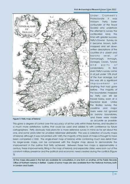
U n d e r C r o m w e l l ’ s<br />
Protectorate it was<br />
William Petty (later<br />
co-founder of the Royal<br />
Society) who undertook<br />
the attempt to survey the<br />
confiscated land, this<br />
time with greater success.<br />
Petty’s Downe Survey, as<br />
it became known, both<br />
mapped and set down<br />
written descriptions of the<br />
counties at a parish and<br />
b a r o n y l e v e l , o f<br />
Fermanagh, Armagh,<br />
Donegal, Cavan, Tyrone<br />
a n d p a r t s o f<br />
Londonderry. In fact,<br />
even Petty’s survey came<br />
in at just under 10% short<br />
of the true acreage, but<br />
this was still a significant<br />
i m p r o v e m e n t o n<br />
anything that had gone<br />
before. The majority of<br />
the boundaries mapped<br />
by Petty can still be<br />
traced today, even at a<br />
townland level. Unlike<br />
the Bodley survey, the<br />
coastline and major<br />
rivers were not ignored<br />
as barony boundaries,<br />
and these were made<br />
Figure 5: Petty map of Ireland<br />
as accurate as possible.<br />
This gave a degree of control over the accuracy of all the units within these frames, and resulted in<br />
a much more satisfactory outline, that could be used and added to with confidence by future<br />
cartographers. Petty obviously had plans for a more extensive survey in mind as he set about this<br />
one, and some years later he unveiled Hiberniae delineatio. This was a collection of county maps<br />
of Ireland; although it was not printed until 1685, the majority of this book of maps is thought to have<br />
been completed c.1666. The single-sheet map of Ireland, while containing much less detail than<br />
his larger-scale maps, can be compared with the Goghe map above to demonstrate the<br />
improvement in the outline that Petty achieved. Between these two maps is approximately a<br />
century; these improvements, filling in the map of Ireland, and especially Ulster, were born out of the<br />
constant military presence and the political and economic need created during the conflicts (Figure<br />
5).<br />
All the maps discussed in the text are available for consultation, in one form or another, at the Public Records<br />
Office of Northern Ireland, in Belfast. Copies of some maps are also available from the National Archives, both<br />
in London and Dublin.<br />
14