Regional Depositional History, Stratigraphy and Palaeogeography ...
Regional Depositional History, Stratigraphy and Palaeogeography ...
Regional Depositional History, Stratigraphy and Palaeogeography ...

Create successful ePaper yourself
Turn your PDF publications into a flip-book with our unique Google optimized e-Paper software.
Journal of Middle East<br />
Petroleum Geosciences<br />
www.eage.org<br />
First Arabian Plate Geology Workshop<br />
<strong>Regional</strong> <strong>Depositional</strong> <strong>History</strong>, <strong>Stratigraphy</strong><br />
<strong>and</strong> <strong>Palaeogeography</strong> of the Shu’aiba<br />
12-15 January 2008, Muscat (Oman)<br />
Goal<br />
The goal of this workshop is to reach a common underst<strong>and</strong>ing<br />
of the stratigraphic framework of the Shu’aiba Formation. During<br />
this workshop local <strong>and</strong> regional information on the Shu’aiba depositional<br />
facies <strong>and</strong> stratigraphy will be shared <strong>and</strong> merged into a consistent regional model at<br />
the scale of the southern Arabian Plate.<br />
Programme<br />
The workshop will consist of 30 oral <strong>and</strong> poster presentations, a full-day core session<br />
(with cores from Oman, Qatar <strong>and</strong> the United Arab Emirates), discussion sessions <strong>and</strong><br />
two optional field trips to the Shu’aiba outcrops in Oman.<br />
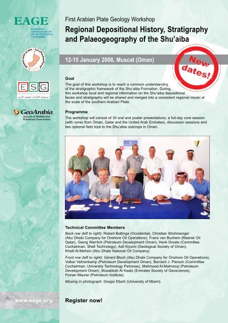
Technical Committee Members<br />
Back row (left to right): Robert Bottinga (Occidental), Christian Strohmenger<br />
(Abu Dhabi Company for Onshore Oil Operations), Frans van Buchem (Maersk Oil<br />
Qatar), Georg Warrlich (Petroleum Development Oman), Henk Droste (Committee<br />
Cochairman, Shell Technology), Adil Kiyumi (Geological Society of Oman),<br />
Khalil Al-Mehsin (Abu Dhabi National Oil Company).<br />
Front row (left to right): Gérard Bloch (Abu Dhabi Company for Onshore Oil Operations),<br />
Volker Vahrenkamp (Petroleum Development Oman), Bernard J. Pierson (Committee<br />
Cochairman, University Technology Petronas), Mahmood Al-Mahrooqi (Petroleum<br />
Development Oman), Musabbah Al Kaabi (Emirates Society of Geoscience),<br />
Florian Maurer (Petroleum Institute).<br />
Missing in photograph: Gregor Eberli (University of Miami).<br />
Register now!
135<br />
Shu’aiba workshop abstracts, GeoArabia, 12–15 January Vol. 12, 2008, No. 4, Oman 2007<br />
Gulf PetroLink, Bahrain<br />
First ArAbiAn PlAte GeoloGy WorkshoP AbstrActs<br />
regional depositional history, stratigraphy <strong>and</strong> palaeogeography of the shu’aiba<br />
12–15 January 2008, Muscat (Oman)<br />
sedimentology, sequence stratigraphy<br />
<strong>and</strong> seismic stratigraphy of the lower<br />
cretaceous shu’aiba Formation of<br />
northwest Abu Dhabi, United Arab<br />
emirates<br />
Ahmed Abdul Ghani (Abu Dhabi Company for<br />
Onshore Oil Operations ),<br />
Christian J. Strohmenger (Abu Dhabi Company<br />
for Onshore Oil Operations), David G. Barwick<br />
(Abu Dhabi Company for Onshore Oil Operations),<br />
Thomas Steuber (The Petroleum Institute, Abu<br />
Dhabi), Suhaila H.A. Al-Mazrooei (Abu Dhabi<br />
Company for Onshore Oil Operations) <strong>and</strong><br />
Naema O. Al-Zaabi (Abu Dhabi Company for<br />
Onshore Oil Operations)<br />
A 3-D seismic analysis over an oil field in northwest<br />
Abu Dhabi was used to map the platformto-basin<br />
geometries of the Lower Cretaceous<br />
Shu’aiba Formation. The areal extent of the interior<br />
platform, the platform margin, the clinoform<br />
belt (prograding wedges), <strong>and</strong> the Bab<br />
Basin were outlined by seismic cross-sections<br />
<strong>and</strong> seismic amplitude maps. Sedimentologic<br />
<strong>and</strong> petrographic core descriptions were used to<br />
identify 12 lithofacies types, ranging from shallow-marine,<br />
rudist-rudstone to deep-marine,<br />
planktonic-foraminifera wackestone <strong>and</strong> shale.<br />
The Shu’aiba deposits of northwest Abu Dhabi<br />
conform to a sequence stratigraphic framework<br />
established for a giant oil field of central Abu<br />
Dhabi. The Shu’aiba transgressive <strong>and</strong> early<br />
highst<strong>and</strong> sequence sets were built by the Ap2<br />
<strong>and</strong> Ap3 sequences. The Shu’aiba late highst<strong>and</strong><br />
sequence set is comprised of the Ap4 <strong>and</strong> Ap5<br />
sequences, <strong>and</strong> the Bab lowst<strong>and</strong> sequence set is<br />
represented by the Ap6 sequence. However, the<br />
platform margin appears to be steeper in northwest<br />
Abu Dhabi, as the area of the interpreted<br />
Upper Aptian (Ap4 <strong>and</strong> Ap5 sequences) distal<br />
clinoform belt is narrower than the one encountered<br />
in central Abu Dhabi.<br />
A combined approach of biostratigraphy, carbon-isotope<br />
stratigraphy <strong>and</strong> strontium-isotope<br />
stratigraphy was used to constrain the sequence<br />
stratigraphic correlation. Rudist bivalves<br />
helped identify the Lower versus Upper Aptian<br />
sequences. Distinct taxa such as Offneria characterized<br />
the Lower Aptian high-energy environments,<br />
but were absent in the Upper Aptian due<br />
to a pronounced extinction event that affected<br />
rudists at the Lower/Upper Aptian transition.<br />
Carbon-isotope curves from individual wells<br />
were used to correlate prograding units, but<br />
the chronostratigraphic calibration to carbon<br />
isotopes proved difficult. Numerical ages were<br />
obtained for selected levels using strontium-isotope<br />
stratigraphy. This helped develop a more<br />
precise chronostratigraphy of the Shu’aiba<br />
Formation in the studied region.<br />
sediment control on fracture network of<br />
cretaceous reservoirs, northern oman<br />
Salah H.H. Al-Dhahab (Heriot Watt University,<br />
UK )<br />
The geometrical aspects of the fracture networks<br />
in the Cretaceous reservoirs of northern Oman<br />
were mainly controlled by the tectonic regime<br />
(“deformation”), <strong>and</strong> to a lesser extent, by the<br />
type of lithofacies (“sediment”) deposited in the<br />
various fields. A review of outcrop analogues<br />
<strong>and</strong> the detailed descriptions of borehole-image<br />
logs indicated that the fractures in northern<br />
Oman can be divided into three types: (1) dispersed<br />
(“background”) fractures in which the<br />
geometry (“vertical extent”) is highly dependent<br />
on sediment types; (2) fracture corridors (“clusters”)<br />
<strong>and</strong> fault-related fractures that appear to<br />
cut through the whole Cretaceous reservoir succession;<br />
<strong>and</strong> (3) fold-related fractures, which are<br />
related to local tectonic effects.<br />
The mechanical layering is typified in northern<br />
Oman <strong>and</strong> can also be seen in the southeastern<br />
fields of northern Oman, where only the lower<br />
part of the Cretaceous reservoir occurs. The dynamic<br />
property of those fractures (“conductivity”)<br />
is governed by: (1) the diagenetic history of<br />
the reservoir, <strong>and</strong> (2) the present-day magnitude<br />
<strong>and</strong> orientation of the stress field. The presentation<br />
will also shed light on the characteristics<br />
<strong>and</strong> modeling of micro-fractures that were observed<br />
in core samples from a few Cretaceous<br />
reservoirs.
Shu’aiba workshop abstracts, 12–15 January 2008, Oman<br />
Facies <strong>and</strong> high-resolution sequence<br />
stratigraphy of the Shu’aiba Formation,<br />
Shaybah field, Saudi Arabia<br />
Nasser Al-Ghamdi (Saudi Aramco ) <strong>and</strong> James F. Read (Virginia Tech<br />
University, USA)<br />
The Early Cretaceous (Aptian) Shu’aiba Formation<br />
in Shaybah field, Saudi Arabia, contains a giant carbonate<br />
reservoir that formed on a regional carbonate<br />
ramp bordering an intra-shelf basin. The succession<br />
consists of a composite sequence of seven highfrequency<br />
sequences. Sequences 1 <strong>and</strong> 2 formed a<br />
deeper open platform of Palorbitolina-Lithocodium<br />
wackestone, with maximum flooding marked by<br />
planktic foram mudstone. Sequence 2 built relief<br />
over the northern <strong>and</strong> southern blocks, which<br />
are separated by an intra-platform depression.<br />
Sequence 1 <strong>and</strong> part of sequence 2 form the composite<br />
sequence transgressive systems tract (TST).<br />
The remaining sequences (3 to 7) developed a platform<br />
that was rimmed by rudist rudstone, backed<br />
by a rudist floatstone back-bank <strong>and</strong> a lagoonal fine<br />
skeletal peloidal packstone. The slope facies were<br />
fine skeletal fragmented packstone. Aggradational<br />
sequences 3 to 5 made-up the composite sequence<br />
early highst<strong>and</strong> systems tract (HST). Progradational<br />
sequences 6 <strong>and</strong> 7 formed the composite sequence<br />
late highst<strong>and</strong> systems tract. These sequences<br />
marked the deterioration of the Offneria rudist barrier<br />
<strong>and</strong> deposition of widespread lagoonal deposits.<br />
Accommodation space in the lagoon may have been<br />
created by syn-depositional normal faulting that<br />
moved the northern block down. The deposition of<br />
the Shu’aiba Formation on the platform was terminated<br />
by a long-term sea-level fall <strong>and</strong> karsting. The<br />
succession is dominated by fourth-order sequences<br />
(duration of approximately 400 thous<strong>and</strong> years, Ky)<br />
<strong>and</strong> parasequences (100 Ky), which were driven by<br />
long-term <strong>and</strong> short-term eccentricity, respectively,<br />
similar to the Pacific guyots of this age. This suggests<br />
that climate during the Early Cretaceous may<br />
have been cooler with small ice sheets, <strong>and</strong> was not<br />
an ice-free greenhouse period.<br />
Integrated 3-D reservoir modeling of a<br />
complex heavy oil fractured carbonate in the<br />
Qarn Alam field, northern Oman<br />
Fahad S.M. Al Hadhrami (Shell International E&P,<br />
The Netherl<strong>and</strong>s ),<br />
G. Engen (Petroleum Development Oman),<br />
Keith Rawnsley (Petroleum Development Oman) <strong>and</strong><br />
Rick Penney (Petroleum Development Oman)<br />
The Shu’aiba reservoir in the Qarn Alam field is<br />
136<br />
currently being developed using thermally assisted<br />
gas oil gravity drainage (TAGOGD). In this process<br />
steam is injected into the intensely fractured<br />
reservoir, at the crest of the field, so as to heat the<br />
oil in the low-permeability matrix. This procedure<br />
drains the oil into the oil rim where it collects in<br />
fractures.<br />
During the process, the viscosity of the oil is<br />
significantly reduced thus accelerating the GOGD<br />
process. To address the key reservoir uncertainties,<br />
an integrated modeling approach was adopted.<br />
It integrated reprocessed 3-D seismic, boreholeimagelog<br />
<strong>and</strong> drilling losses data, <strong>and</strong> provided a<br />
better definition of the structural surface <strong>and</strong> fault<br />
locations.<br />
Faults were accurately mapped <strong>and</strong> positioned at<br />
the fault cut-outs at the wells. Outcrop data were<br />
used to map the different reservoir sequences of the<br />
Shu’aiba reservoir, resulting in a better definition<br />
of the fault cut-outs. Shell’s 3-D fracture-modeling<br />
software was used to characterize the fractures.<br />
Because the static <strong>and</strong> dynamic data were limited,<br />
fracture modeling was a challenge. A multiple<br />
realization approach addressed the uncertainty<br />
in the fracture distribution. Simulation models<br />
suggested a large increase in oil recovery ranging<br />
from 3–5 % under cold GOGD development to<br />
20–35% under steam injection (TAGOGD).<br />
Shu’aiba Formation, Block 9, northern Oman<br />
Bader Al-Kalbani<br />
(Occidental of Oman ),<br />
William M. Fitchen (Occidental of Oman),<br />
A. Al Maimani (Occidental of Oman),<br />
T. Reid (Occidental of Oman) <strong>and</strong><br />
S. Al Salmi (Occidental of Oman)<br />
Wells Saqr-1 <strong>and</strong> 2, Diba-1 <strong>and</strong> Reham-1 are located<br />
on three small fault-block structures <strong>and</strong> produce<br />
oil from the Cretaceous Lower Shu’aiba reservoir<br />
in northern Oman. The reserves in each structure<br />
are not significant. Cores cut from the Saqr West-<br />
1 well, which was drilled on a small structure<br />
between Saqr <strong>and</strong> Diba fields, suggested that the<br />
lithology controls the distribution of hydrocarbons.<br />
Well Saqr-3 confirmed pay-on-logs 80 ft below the<br />
mapped oil-water contact in the Saqr structure.<br />
The Diba-2 horizontal well confirmed movable<br />
hydrocarbon 65 ft deeper in the Diba-Saqr West<br />
structure. Logs, Special Core Analysis (SCAL) <strong>and</strong><br />
production tests confirmed that lithology controls<br />
the hydrocarbon distribution in the Lower Shu’aiba<br />
reservoir in the central Block 9 resulting in added<br />
reserves <strong>and</strong> new well locations.
Alternative sequence stratigraphic<br />
framework in the upper part of the Shu’aiba<br />
Formation in field H, onshore Abu Dhabi,<br />
United Arab Emirates<br />
Gérard Bloch (Abu Dhabi Company for Onshore Oil<br />
Operations )<br />
Field “H” is a low-relief structure located 15 km<br />
south of the largest Shu’aiba field in Abu Dhabi.<br />
In 2001, a thorough integration of 3-D seismic, log<br />
<strong>and</strong> core data from four wells was performed. It<br />
resulted in a comprehensive depositional model of<br />
the Shu’aiba Formation in this field. The study was<br />
supplemented by a comprehensive regional review<br />
of the development of the Shu’aiba Formation that<br />
integrated the available biostratigraphic <strong>and</strong> isotope<br />
data, <strong>and</strong> a high-resolution sequence stratigraphic<br />
framework was proposed.<br />
In 2004, a joint ADCO-ExxonMobil detailed seismic-stratigraphic<br />
study covering both field “H”<br />
<strong>and</strong> the largest Shu’aiba field was completed <strong>and</strong><br />
a new high-resolution sequence-stratigraphic<br />
framework was proposed. The topic of this paper<br />
is to compare the two frameworks <strong>and</strong> to highlight<br />
differences between them that occur in the upper<br />
part of the Shu’aiba sequence, at or near the Early<br />
to Late Aptian time line.<br />
The Shu’aiba geological setting in field “H” is quite<br />
unique in Abu Dhabi as it represents a distinctive<br />
transition from a platform setting into a back-platform,<br />
intra-seaway to a deep lagoonal setting. The<br />
transition exhibits strong lateral facies variations in<br />
the middle Unit H of the Shu’aiba Formation <strong>and</strong><br />
in the lower part of the overlying Unit I: from highpermeability<br />
rudistic facies to low-permeability<br />
non-rudistic facies. The vertical succession of facies<br />
in Unit I strongly suggests that the sedimentation<br />
over the southern part of the main Shu’aiba platform<br />
took place over the time interval near the<br />
Early to Late Aptian time line.<br />
Advanced well design to address the<br />
locally complex geological setting of the<br />
Shu’aiba Formation, onshore Abu Dhabi,<br />
United Arab Emirates<br />
Gérard Bloch (Abu Dhabi Company for Onshore Oil<br />
Operations )<br />
The Shu’aiba Formation is locally quite complex<br />
with strong lateral variations in its middle Unit<br />
H. In a distance of only a few hundred meters the<br />
high-permeability rudistic facies (permeability in<br />
the order of 100 to 1,000s mD) pass laterally to the<br />
low-permeability non-rudistic facies (permeability<br />
137<br />
Shu’aiba workshop abstracts, 12–15 January 2008, Oman<br />
in the order of 1 to 10 mD). This transition controls<br />
the oil distribution in a low-relief structure located<br />
south of the largest Shu’aiba field in onshore Abu<br />
Dhabi. In the low-relief structure the low-permeability<br />
reservoirs are water-bearing due to a significant<br />
level of capillary entry pressure value.<br />
At the time of this study (year 2001), four wells<br />
provided control for defining the shelf edge. The<br />
lateral facies boundary was well-expressed on<br />
newly acquired 3-D seismic data by a significant<br />
time thickness variation. However, even seismic inversion<br />
techniques could not differentiate between<br />
the two facies because the porosity is very similar,<br />
in the order of 25–30%.<br />
A very thorough integration of seismic, log, biostratigraphic,<br />
isotope <strong>and</strong> core data, supplemented<br />
by a regional synthesis of the Shu’aiba’s depositional<br />
setting led to a comprehensive depositional<br />
model in a well-defined sequence stratigraphic<br />
framework. Based on this effort, a proposal was<br />
made to drill two appraisal/development wells<br />
with three holes each. The two appraisal vertical/<br />
deviated pilot holes are separated by about 1,200<br />
ft laterally <strong>and</strong> the horizontal production section is<br />
3,000 ft long.<br />
The results that will be presented were consistent<br />
with expectations. The generation of a 3-D geological<br />
model <strong>and</strong> the related simulation work led to a<br />
Full Field Development Plan that has been successfully<br />
implemented. The field is now producing as<br />
predicted by the dynamic model.<br />
Sequence stratigraphic framework of the<br />
Aptian Shu’aiba Formation in Oman<br />
Henk J. Droste (Shell Technology Oman<br />
)<br />
The Shu’aiba Formation is the most important<br />
carbonate reservoir for oil in Oman. The formation<br />
shows a complex internal stratigraphic architecture<br />
<strong>and</strong> significant lateral variations in reservoir<br />
character. A sequence stratigraphic framework is<br />
presented that explains these regional variations.<br />
Incorporation of seismic data allowed significant<br />
refinement <strong>and</strong> improvement of the previous models,<br />
which were based on well data only.<br />
The Shu’aiba Formation, which is up to 130 m<br />
thick, occurs as a unit within a Cretaceous epeiric<br />
carbonate platform system. It conformably overlies<br />
the dense carbonates of the Hawar Member<br />
(top Kharaib Formation) <strong>and</strong> is unconformably<br />
overlain by the shales of the Nahr Umr Formation.<br />
The Shu’aiba Formation is built by three major<br />
genetic units (systems tracts) each with a different
Shu’aiba workshop abstracts, 12–15 January 2008, Oman<br />
distribution, both in time <strong>and</strong> space, in response to<br />
different trends in relative sea-level change. Each<br />
of these contains different facies associations <strong>and</strong><br />
internal stacking patterns <strong>and</strong>, consequently, also<br />
different reservoir architecture.<br />
The lowermost unit is Early Aptian in age <strong>and</strong><br />
includes the Hawar Member <strong>and</strong> the basal Shu’aiba<br />
Formation. It forms a transgressive systems tract<br />
(TST) with laterally extensive shallow-marine<br />
to intertidal sediments followed by shallowmarine<br />
algal limestones that transgressed over<br />
exposed limestones of the Kharaib Formation.<br />
The development of algal-mound complexes<br />
led to a differentiation on the platform. Between<br />
these mounds fine-grained, in places organic-rich,<br />
deeper-water deposits represent the maximum<br />
flooding interval (MFI).<br />
The second unit is Early to Late Aptian in age, <strong>and</strong><br />
consists of a highst<strong>and</strong> systems tract (HST) with<br />
progradational geometries. The “carbonate factory”<br />
was then dominated by rudist-biostrome complexes,<br />
which colonized the mounds. Intermound<br />
depressions were progressively filled leading to the<br />
formation of a large platform that surrounded an<br />
intra-platform basin.<br />
The third unit was formed by a lowst<strong>and</strong> systems<br />
tract (LST) deposited in the Late Aptian during <strong>and</strong><br />
following a regional drop in sea level. The drop<br />
caused subaerial exposure of the HST platform<br />
<strong>and</strong> the influx of fine-grained clastics. The early<br />
LST contained off-lapping wedges of argillaceous<br />
carbonates <strong>and</strong> carbonate-rich claystones along the<br />
margins of the intra-platform basin. Ultimately the<br />
whole platform interior was exposed <strong>and</strong> a late<br />
LST wedge was deposited along the ocean margin<br />
of the platform. The basal clays of the Nahr Umr<br />
Formation formed the TST, which is capped by an<br />
MFI, the Marker Limestone Bed, located a few meters<br />
above the Shu’aiba Formation.<br />
Unraveling the depositional history of<br />
the Shu’aiba Formation at a regional scale:<br />
Key success factors<br />
Gregor P. Eberli (University of Miami, USA<br />
) <strong>and</strong> Bernard J. Pierson<br />
(University Technology Petronas, Malaysia)<br />
An 18-month review of the Shu’aiba system in an<br />
ADNOC/Shell joint project resulted in a major<br />
advance of the underst<strong>and</strong>ing of its depositional<br />
history. This improved knowledge can now be exploited<br />
in focused exploration plays. The analyses<br />
provided important insights for unveiling new<br />
knowledge from existing data sets <strong>and</strong> experts.<br />
The key factors were meticulous planning, the par-<br />
138<br />
ticipation of experienced geoscientists from various<br />
disciplines <strong>and</strong> countries, <strong>and</strong> the integration of<br />
existing data sets that ranged in quality from excellent<br />
to mediocre.<br />
The planning relied on the integration of existing<br />
data sets <strong>and</strong> involvement of experts from various<br />
disciplines. The integration <strong>and</strong> quality control<br />
of the data from various vintages <strong>and</strong> areas was<br />
a difficult but crucial task for achieving success.<br />
After completion of this preliminary work the<br />
geoscientists benefited from the following factors.<br />
(1) A complete coverage of seismic <strong>and</strong> well data<br />
over Abu Dhabi compiled in a single, normalized<br />
format. Data from more than 370 wells were quality-controlled<br />
<strong>and</strong> loaded in a new project on IP. (2)<br />
Seismic facies identification <strong>and</strong> extraction proved<br />
successful in a study of a 3-D survey over a giant<br />
Shu’aiba field in Abu Dhabi in 2002–2003. This<br />
method was successfully applied to the regional<br />
study, integrating both 3-D <strong>and</strong> 2-D data. (3) Core<br />
material was available for the analysis <strong>and</strong> mapping<br />
of rock facies for correlation with the seismic<br />
data <strong>and</strong> evaluation of the geological model. (4)<br />
Interpretations could be shared across borders<br />
without revealing confidential data. Relevant results<br />
of analyses <strong>and</strong> interpretations were shared<br />
with neighboring countries, allowing the development<br />
of regional paleo-geographic maps.<br />
In a final analysis, the assembly of all the existing<br />
data sets presented (a) an unprecedented opportunity<br />
for mining by scientists from various disciplines<br />
<strong>and</strong> companies; <strong>and</strong> (b) the integration of<br />
existing regional knowledge <strong>and</strong> new ideas. Both<br />
aspects taken together resulted in a leap forward<br />
towards the underst<strong>and</strong>ing of an hitherto littleknown<br />
geologic system.<br />
<strong>Regional</strong> Shu’aiba reservoir prediction<br />
integrating seismic attributes <strong>and</strong> sequence<br />
stratigraphy, Blocks 9 <strong>and</strong> 27, Oman<br />
William M. Fitchen (Occidental of Oman ), D. Enns (Occidental of Oman),<br />
T. Reid (Occidental of Oman) <strong>and</strong><br />
L. Van Wijhe (Occidental of Oman)<br />
The top Shu’aiba seismic horizon attributes, seismic<br />
facies, <strong>and</strong> isochore maps tied to a sequence<br />
stratigraphic framework in Sa’fah field provided<br />
a robust regional model for the distribution of the<br />
Shu’aiba reservoir throughout Blocks 9 <strong>and</strong> 27,<br />
northern Oman. The Upper Shu’aiba Formation is<br />
subdivided into three dominantly progradational<br />
third-order composite sequences (USh1, USh2, <strong>and</strong><br />
USh3), while the Lower Shu’aiba Formation is subdivided<br />
into three dominantly aggradational thirdorder<br />
composite sequences (LSh1, LSh2, LSh3).
In Blocks 9 <strong>and</strong> 27, the Shu’aiba fields are either<br />
structural-stratigraphic traps (Sa’fah) or small<br />
structural traps, with column heights of less than<br />
150 ft. Though regionally porous, the Lower<br />
Shu’aiba produces only where Upper Shu’aiba basinal<br />
facies are well-developed <strong>and</strong> form a suitable<br />
seal. In these areas, the upper part of the Shu’aiba<br />
interval tends to be composed of high-impedance<br />
mudstones overlain by low-impedance Nahr Umr<br />
shale (e.g. Saqr, Saqr West, Diba, <strong>and</strong> Reham fields),<br />
with corresponding high-impedance contrast.<br />
The USh1 <strong>and</strong> USh2 composite sequences contain<br />
thick (up to 150 ft), porous highst<strong>and</strong> systems<br />
tracts that extend to or near the top of the Shu’aiba<br />
<strong>and</strong> have low-impedance contrast with overlying<br />
Nahr Umr shale (e.g. Sa’fah, Rayyan, Rawdah,<br />
Hebah, Badr, Dhiya, Dhiya West, Wadi Rafash,<br />
<strong>and</strong> Khamilah fields). Prominent USh2 ramp margin-parallel<br />
amplitude b<strong>and</strong>s reflect prograding<br />
shoreface <strong>and</strong> ramp margin deposits composed of<br />
rudist wackestone to grainstone, grading seaward<br />
to rudist-stromatoporoid-algal coalesced bioherm<br />
<strong>and</strong> foreslope facies <strong>and</strong> deeper ramp burrowed to<br />
laminated mudstones.<br />
The USh3 composite sequence filled the basin<br />
seawards of the USh2 terminal ramp margin <strong>and</strong><br />
consists of at least four high-frequency sequences<br />
composed of alternating lime mudstones/shales<br />
<strong>and</strong> 20–30 ft thick peloidal skeletal packstone/<br />
grainstone with isolated rudist mounds. The best<br />
reservoir quality in the USh3 is developed on interpreted<br />
local highs (e.g. Sa’fah Far West, Lekhwair,<br />
Malaan, Daleel, Jalal <strong>and</strong> Al Barakah fields); southeasterly<br />
progradation was common <strong>and</strong> may reflect<br />
paleo-wind or paleo-storm orientation from the<br />
northwest. Top-USh3 amplitude patterns are complicated<br />
by the complex toplap relationships present<br />
in this composite sequence. Where thick lime<br />
mudstones occur at the top of the sequence, they<br />
have high-impedance contrast with the overlying<br />
Nahr Umr; where thick porous packstone/grainstone<br />
is present, it has low-impedance contrast with<br />
the overlying Nahr Umr shale. Seismic wedge models<br />
<strong>and</strong> synthetic seismograms were constructed to<br />
confirm the relationships described herein.<br />
Safah field: Upper Shu’aiba reservoir<br />
development at the southern edge of<br />
an isolated Aptian Platform,<br />
Block 9, northern Oman<br />
William M. Fitchen<br />
(Occidental of Oman )<br />
Sa’fah field was developed within three interpreted<br />
composite sequences of the Upper Shu’aiba<br />
Formation (USh1, USh2, USh3), along the southern<br />
139<br />
Shu’aiba workshop abstracts, 12–15 January 2008, Oman<br />
edge of a large (50 x 25 km), NE-elongated isolated<br />
platform (Sa’fah Platform). The platform was<br />
interpreted to have developed during the Late<br />
Barremian-Early Aptian along the trend of the Sa’fah-<br />
Lekhwair Arch, as documented by thickening of the<br />
Lower Shu’aiba sequences. Composite sequences<br />
<strong>and</strong> their component high-frequency sequences<br />
(HFS) were interpreted through the integration<br />
of core, wireline log <strong>and</strong> 3-D seismic data. The<br />
USh1 sequence forms an isolated, 6 x 3 km, 150-ftthick<br />
rudist-shoal complex on the eastern edge of<br />
Sa’fah field. The entirely subtidal shoal complex<br />
consists of several upward-coarsening successions<br />
of whole rudist mud-dominated packstone to<br />
grain-dominated packstone with increasing rudist<br />
fragmentation <strong>and</strong> current lamination.<br />
Uppermost USh1 rudist grainstones are overlain<br />
abruptly by an erosional contact with intra-clasts,<br />
followed by fenestral mudstones, suggesting an<br />
abrupt seaward shift in facies tracts. The overlying<br />
30 ft succession consists of a cyclic succession of<br />
subtidal peloid-foram mud-dominated packstones<br />
overlain by intertidal fenestral mudstones <strong>and</strong>/or<br />
eroded hardground surfaces with truncated burrows/borings/root<br />
traces. This succession is interpreted<br />
to represent the inner ramp lagoonal isl<strong>and</strong><br />
facies of the USh2 sequence. Downdip of the USh1<br />
shoal complex, the USh2 sequence is composed<br />
of four high-frequency sequences (HFS) that prograded<br />
the ramp margin an additional 2.5–5 km<br />
basinward. The lower three HFS have proportionally<br />
thicker transgressive systems tracts composed<br />
of dysaerobic shale-rich Planolites-burrowed mudstone<br />
grading updip <strong>and</strong> vertically to porous outer<br />
ramp aerobic Thalassin-oides-burrowed peloid<br />
wackestone <strong>and</strong> fine peloid packstone. The upper<br />
two HFS exhibit upward-shallowing successions<br />
from foreslope stromatoporoid–rudist floatstone to<br />
ramp margin rudist-stromatoporoid-algal boundstone,<br />
representing moderate-energy environments<br />
near wave base. Boundstones pass l<strong>and</strong>ward to<br />
rudist-skeletal wackestone <strong>and</strong> floatstone.<br />
Following the deposition of the USh2 sequence, the<br />
platform was subjected to moderate meteoric diagenesis<br />
<strong>and</strong> was only intermittently flooded while<br />
the USh3 (“Bab”) sequence was deposited largely<br />
seaward of the USh2 margin. In the Sa’fah area, the<br />
USh3 is composed of at least three HFS. The oldest<br />
HFS developed a laterally discontinuous, 120-ftthick<br />
fringing reef complex one km seaward of the<br />
USh2 margin, with a deep mud-dominated lagoon<br />
on the l<strong>and</strong>ward side. The two younger HFS offlap<br />
the older HFS fringing reef complex, <strong>and</strong> consist of<br />
more shale-dominated transgressive systems tracts<br />
overlain by a 20–30-ft-thick progradational rudist<br />
shoreface/shoal complexes deposited under relatively<br />
low accommodation conditions.
Shu’aiba workshop abstracts, 12–15 January 2008, Oman<br />
Al Barakah field: Upper Shu’aiba reservoir<br />
development within the Bab Basin,<br />
Block 9, northern Oman<br />
William M. Fitchen<br />
(Occidental of Oman ) <strong>and</strong><br />
Jason Rush (Occidental of Oman)<br />
Al Barakah field, discovered in 1992, produces oil<br />
<strong>and</strong> associated gas from two reservoir zones in the<br />
Upper Shu’aiba USh3 (“Bab”) sequence. The reservoir<br />
zones are compartmentalized by NW-trending<br />
normal faults into five fault blocks, <strong>and</strong> vertically<br />
separated by low-permeability shale to lime-mudstone<br />
facies. Shallow-water carbonate facies were<br />
initially localized to a NE-trending syndepositional<br />
high, the Al Barakah Arch, <strong>and</strong> subsequently prograded<br />
towards the southeast.<br />
The oldest reservoir zone (Zone C) consists of an<br />
aggradational sequence of Orbitolina shale, peloidforam<br />
packstone/wackestone, <strong>and</strong> rudist-algal<br />
boundstone/packstone, which is localized to the<br />
NE-trending axis of the field. This sequence is interpreted<br />
as a discontinuous fringing reef to low-energy<br />
shoreface succession. Zone C reaches a maximum<br />
thickness of 50 ft, but the width of the rudist-algal<br />
boundstone facies parallel to depositional dip (SE)<br />
is only 0.5–0.7 km. Cores exhibit abundant secondary<br />
porosity, suggesting early subaerial exposure<br />
<strong>and</strong> leaching. Degradation of permeability in the<br />
underlying <strong>and</strong> laterally equivalent peloid-foram<br />
wackestone facies is attributed to an increase in<br />
detrital clay drapes, pressure solution features <strong>and</strong><br />
lime mud <strong>and</strong> a decrease in skeletal grains. Zone<br />
C is sealed updip (northwest) by pinch-out onto<br />
a base seal of older Orbitolina shales, <strong>and</strong> by the<br />
overlying Nahr Umr shale. This suggests a relative<br />
fall in sea-level due to possible syndepositional uplift<br />
<strong>and</strong>/or a fall in eustatic sea-level.<br />
Zone B is either absent or very thin across the crest<br />
of Zone C <strong>and</strong> thickens to over 20 ft basinward;<br />
downdip, it is separated from Zone C by a shale unit.<br />
Zone B consists of an upward-shallowing succession<br />
of Orbitolina mudstone, stromatoporoid-rudist<br />
floatstone, small rudist floatstone, <strong>and</strong> fine skeletal<br />
grain-dominated packstone with rudist fragments.<br />
Secondary porosity development with local infiltration<br />
of overlying Nahr Umr Shale is attributed<br />
to subaerial exposure <strong>and</strong> meteoric leaching at the<br />
top-Shu’aiba unconformity. The combined effects<br />
of stratigraphic <strong>and</strong> structural compartmentalization,<br />
localized rudist-algal buildup development<br />
<strong>and</strong> subsequent secondary porosity development<br />
have complicated efforts to efficiently waterflood<br />
the reservoirs.<br />
140<br />
Reservoir compartmentalization <strong>and</strong><br />
waterflood response in a Shu’aiba giant:<br />
Safah field, northern Oman<br />
William M. Fitchen (Occidental of Oman ), S. Al-Busaidy (Occidental of<br />
Oman), H. Al-Hashmi (Occidental of Oman),<br />
H. Al-Rashdi (Occidental of Oman), K. Al-Riyami<br />
(Occidental of Oman), A. Isdiawan (Occidental of<br />
Oman), M. Romero (Occidental of Oman),<br />
M. Tanakov (Occidental of Oman) <strong>and</strong><br />
H. Yang (Occidental of Oman)<br />
Integration of core, log, 3-D seismic, surveillance,<br />
PVT (pressure-volume-temperature), oil geochemistry<br />
<strong>and</strong> production data into a full-field geologic<br />
model <strong>and</strong> history-matched reservoir simulation<br />
models has resulted in an improved underst<strong>and</strong>ing<br />
of reservoir compartmentalization, greater confidence<br />
in infill <strong>and</strong> injector well planning, <strong>and</strong> additional<br />
flank drilling opportunities in this maturing<br />
waterflood program. Stratigraphic compartmentalization<br />
is related to basinward progradation of three<br />
composite sequences (Upper Shu’aiba sequences<br />
USh1, USh2 <strong>and</strong> USh3) <strong>and</strong> their internal high-frequency<br />
sequences, setting up five major reservoir<br />
compartments (East, Main, West Lobe, Far West, <strong>and</strong><br />
FF West). Further structural compartmentalization<br />
is caused by low-offset, WNW- <strong>and</strong> NNW-trending<br />
conjugate fault sets, which appear to be partially<br />
sealing in places, resulting in variations in fluid contacts<br />
<strong>and</strong> post-depletion reservoir pressures.<br />
The Sa’fah East compartment is isolated from Sa’fah<br />
Main by a NW-trending normal fault with 10–30<br />
ft of down-to-the-east throw, <strong>and</strong> by the west <strong>and</strong><br />
southwest transition from permeable highst<strong>and</strong><br />
ramp-margin facies of USh1 to low-permeability<br />
transgressive deeper ramp facies of USh2. The USh2<br />
sequence in Sa’fah Main is internally composed of<br />
four high-frequency sequences that transition from<br />
aggradational <strong>and</strong> mudstone dominated at the<br />
base, to more progradational <strong>and</strong> rudist-rich at the<br />
top. The Sa’fah Main compartment is isolated from<br />
Sa’fah West Lobe by a southwestward transition<br />
from permeable, USh2 highst<strong>and</strong> ramp margin facies<br />
to impermeable mudstones of the basal USh3<br />
transgressive systems tract.<br />
The Sa’fah West Lobe is a NW-SE elongate trend of<br />
coalesced USh3 aggradational rudist-stromatoporoid<br />
mounds that parallel the USh2 ramp margin.<br />
These mounds represent the highst<strong>and</strong> systems<br />
tract of the basal USh3 high-frequency sequence.<br />
Inferred sub-compartments of Sa’fah West Lobe<br />
are attributed to along-strike variations in mound<br />
development. Two younger USh3 high-frequency
sequences offlap the basal USh3 mound sequence.<br />
The grain-rich (ooid-peloid) highst<strong>and</strong> units of<br />
these two sequences comprise the Sa’fah Far West<br />
<strong>and</strong> FF West compartments. The next phase of<br />
reservoir studies is focusing on mapping <strong>and</strong> prediction<br />
of fracture corridors prone to early water<br />
breakthrough.<br />
Sequence stratigraphy of the Shu’aiba<br />
Formation <strong>and</strong> Hawar Member (Biyadh<br />
Formation) tectono-stratigraphic sequence<br />
John C. Hohman (ExxonMobil Exploration Company,<br />
USA ), I.A. Abdulla<br />
Al-Emadi (Qatar Petroleum Company) <strong>and</strong><br />
Mamdouh E. Zahran (Qatar Petroleum Company)<br />
Well-log <strong>and</strong> core data from Qatar <strong>and</strong> adjacent<br />
Bahrain, Abu Dhabi, Iran <strong>and</strong> Saudi Arabia have<br />
been used to identify <strong>and</strong> evaluate the Lower<br />
Cretaceous Shu’aiba Formation <strong>and</strong> Hawar Member<br />
(Biyadh Formation) tectono-stratigraphic sequence.<br />
Consistent with tectono-stratigraphic terminology,<br />
the Shu’aiba-Hawar sequence is bounded by<br />
prominent, regional unconformities. Between these<br />
unconformities, the sequence is a distinctive threepart<br />
succession of deposits that begins with siliciclastics<br />
<strong>and</strong> ends with carbonates.<br />
The initial siliciclastic lowst<strong>and</strong> phase of deposition<br />
is characterized by a thick wedge of fluvial<br />
s<strong>and</strong>stones typical of the Biyadh Formation. These<br />
deposits thin from west to east <strong>and</strong> transition upward<br />
into marginal marine deposits as they onlap<br />
the basal unconformity. Ultimately, these deposits<br />
grade into thin marine shale that characterizes the<br />
Hawar Member before lapping out entirely to the<br />
east.<br />
An abrupt shift from siliciclastic to carbonate deposition<br />
was recorded by transgressive carbonates<br />
that formed a relatively thin but laterally extensive<br />
ramp referred to as the Lower Shu’aiba Platform.<br />
The subsequent highst<strong>and</strong> phase of carbonate deposition<br />
was strongly influenced by the development<br />
of intra-shelf basins. Within these basins, the<br />
highst<strong>and</strong> was marked by a thin basinal carbonate,<br />
while relatively thick platform carbonates, referred<br />
to as the Upper Shu’aiba Platform, were developed<br />
along their margins.<br />
Carbonate deposition was terminated by tectonic<br />
tilting that uplifted the northeastern part of the<br />
platform while generating subsidence in the<br />
southwestern part. Subsequently, much of the<br />
uplifted platform in the northeast was removed<br />
by erosion. The southwestern region was buried<br />
by an overlying siliciclastic wedge that onlaps <strong>and</strong><br />
thins onto the uplifted portion of the platform. This<br />
141<br />
Shu’aiba workshop abstracts, 12–15 January 2008, Oman<br />
unconformity surface marks the upper extent of<br />
the Shu’aiba-Hawar (Biyadh) tectono-stratigraphic<br />
sequence.<br />
The Barremian-Lower Aptian Qishn<br />
Formation (Al-Huqf Area, Oman):<br />
An outcrop analogue for the Kharaib<br />
<strong>and</strong> Shu’aiba reservoirs<br />
Adrian Immenhauser (Ruhr-Universität Bochum,<br />
Germany ),<br />
H. Hillgärtner (Vrije Universiteit Amsterdam,<br />
The Netherl<strong>and</strong>s), U. Sattler (Vrije Universiteit<br />
Amsterdam, The Netherl<strong>and</strong>s), G. Bertotti (Vrije<br />
Universiteit Amsterdam, The Netherl<strong>and</strong>s),<br />
Pascal Schoepfer (Al Furat Petroleum Company, Syria),<br />
Volker Vahrenkamp (Petroleum Development Oman),<br />
Henk J. Droste (Shell Technology Oman),<br />
Peter Homewood (Oman Geoconsultants),<br />
Thomas Steuber (The Petroleum Institute, Abu Dhabi)<br />
<strong>and</strong> J.P. Masse (Marseilles University, France)<br />
Limestones of the middle Cretaceous Qishn<br />
Formation are exposed in the Al-Huqf Area of<br />
Oman. These carbonates preserved reservoir properties<br />
due to shallow burial <strong>and</strong> an arid post-exhumation<br />
climate. This characteristic makes the Qishn<br />
Formation an excellent outcrop analogue for the<br />
Upper Kharaib <strong>and</strong> Lower Shu’aiba oil reservoirs in<br />
the Interior Oman basins. The Qishn Formation is<br />
middle Barremian to mid-Early Aptian, the Hawar<br />
Member (equivalent) is earliest Aptian in age. The<br />
paleo-environments range from the tidal mudflat<br />
to the argillaceous platform setting (outer ramp).<br />
In terms of sequence stratigraphy, four large-scale<br />
transgressive-regressive cycles of Cretaceous age<br />
(Jurf <strong>and</strong> Qishn formations) were distinguished.<br />
Sequence I, termed Jurf Formation, is the equivalent<br />
of the Lekhwair, the Lower Kharaib <strong>and</strong> possibly<br />
older Cretaceous units. Sequence II, forming the<br />
base of the overlying Qishn Formation represents<br />
the equivalent of the Upper Kharaib. Portions<br />
of Sequence III form the Hawar Member, <strong>and</strong><br />
Sequence IV is the equivalent of the Lower Shu’aiba<br />
Formation. At least two lower orders of cycles are<br />
superimposed on these four sequences. Total porosity<br />
with a mean of 19.3% (st<strong>and</strong>ard deviation =<br />
8.74%) <strong>and</strong> permeability with a mean of 6.36 mD<br />
(st<strong>and</strong>ard deviation = 6.57 mD) characterize the<br />
Qishn Formation limestones. The lateral variability<br />
(greater than 100 m) of porosity <strong>and</strong> permeability<br />
values within specific intervals is substantial <strong>and</strong><br />
matches or even exceeds stratigraphic variability.<br />
Spectral gamma-ray logs from the Qishn limestones<br />
recorded in the outcrops are dominated by the<br />
Uranium (U) spectrum <strong>and</strong> to a lesser degree by the<br />
Thorium (Th) spectrum.
Shu’aiba workshop abstracts, 12–15 January 2008, Oman<br />
The Qishn carbonates in the Al-Huqf outcrops<br />
are extensively fractured. The studied outcrops<br />
display very widespread systematic jointing with<br />
dominant NW-SE to WNW-ESE trends. A second,<br />
subordinate system resulted in a potentially highly<br />
interconnected network. Joints are strictly confined<br />
to specific beds or groups of beds <strong>and</strong> have regular<br />
spacing of between 6 <strong>and</strong> 18 cm. Joints are related<br />
to the regional stress fields <strong>and</strong> did not show significant<br />
changes (in density or direction) in the<br />
vicinity of folds or faults. Faults are typically organized<br />
in corridors consisting of up to several-meterwide<br />
zones with swarms of discrete fault planes.<br />
A characteristic feature of both the Qishn <strong>and</strong> the<br />
Lower Shu’aiba formations is the organization in<br />
rudist-dominated facies: Lithocodium-Bacinella<br />
dominated <strong>and</strong> Orbitolina dominated facies. A<br />
platform-wide correlation of key surfaces based on<br />
Sr-isotope stratigraphy is presently under way.<br />
Facies architecture of Shu’aiba Carbonate<br />
Reservoirs: Global signal <strong>and</strong> composite<br />
sequence framework<br />
Charles Kerans (University of Texas at Austin, USA<br />
)<br />
The Barremian-Aptian (Cretaceous) Shu‘aiba<br />
Formation is an important producing interval in<br />
Oman, the United Arab Emirates (UAE), Saudi<br />
Arabia, <strong>and</strong> Qatar, hosting both vuggy <strong>and</strong> microporous<br />
reservoirs with a common Albian Nahr<br />
Umr Shale seal. Integration of detailed core-based<br />
facies descriptions, wireline logs, <strong>and</strong> to a lesser<br />
extent seismic data, from 12 reservoirs throughout<br />
the region has allowed the recognition of a range<br />
of heterogeneity styles distributed in a predictable<br />
sequence framework.<br />
A global transgression coincident with OAE 1a<br />
<strong>and</strong> marking the start of a latest Barremian-Aptian<br />
third-order composite sequence initiated a threepart<br />
history of transgressive, aggradational, <strong>and</strong><br />
forced-regressive high-frequency sequences. Phase<br />
1 was deposition of a transgressive-dominated shelf<br />
with moderate to high-energy Lithocodium-rich<br />
cycles <strong>and</strong> local microbial buildups forming two<br />
widely recognizable sequences of the transgressive<br />
sequence set (TSS). Limited production from these<br />
sequences occurs in Lekhwair field in Oman, Idd<br />
El Shargi South Dome in Qatar, <strong>and</strong> lower intervals<br />
in Bu Hasa, UAE. This TSS is characterized by<br />
layer-cake, pay-zone architecture, locally made<br />
complicated by fracture-controlled heterogeneities.<br />
Phase 2, the maximum flooding surface (MFS) or<br />
the aggradational phase (early highst<strong>and</strong> sequence<br />
set or HSS) included the hallmark phase of rud-<br />
142<br />
ist-shoal development for the Shu’aiba Formation.<br />
Discontinuous nucleation of rudist-algal buildups<br />
with a colonization stage of glossomyophorids<br />
<strong>and</strong> culmination stage of caprinids formed significant<br />
relief <strong>and</strong> lateral heterogeneity, including<br />
prominent inter-mound channel systems <strong>and</strong> inter-mound<br />
mud-rich dense zones. Localization of<br />
these aggradational rudist buildups was controlled<br />
by thickening of phase 1 sequences, which typically<br />
double in thickness in a km-wide belt that defines<br />
the precursor rim of the Bab Basin.<br />
Phase 3, a progressively more clastic-rich forcedregressive<br />
set of sequences (FRSS) with mixed rudist-microbial<br />
buildups <strong>and</strong> biostromes intercalated<br />
with calcareous shales, formed the final phase of<br />
infill of the intra-shelf basin. Strong impedance contrasts<br />
between shales <strong>and</strong> Orbitolina-algal carbonates<br />
allows clear imaging of this final phase of infill,<br />
setting up opportunities for smaller stratigraphic<br />
trap plays. Exposure of subaerially exposed HSS<br />
during FRSS deposition over the crest of buildups<br />
<strong>and</strong> on emergent salt structures led to the dissolution<br />
<strong>and</strong> reservoir quality enhancement locally.<br />
Comparative architecture of the Early-Late Aptian<br />
carbonate shelf of the Gulf of Mexico illustrates<br />
many parallels to the Shu’aiba composite sequence<br />
architecture <strong>and</strong> supports the timing associated with<br />
the demise of older Barremian (Kharaib-Thamama)<br />
platforms during OAE 1a.<br />
Reservoir architecture of a prograding intrashelf<br />
basin margin: Case study from the<br />
Shu’aiba Formation, United Arab Emirates<br />
David A. Lawrence (Abu Dhabi Company for Onshore<br />
Oil Operations ),<br />
Majid A. Al-Shemsi (Abu Dhabi Company for Onshore<br />
Oil Operations), Linda W. Glass (ExxonMobil<br />
Exploration Company, USA), Christian J. Strohmenger<br />
(Abu Dhabi Company for Onshore Oil Operations),<br />
Ismail Al-Hosani (Abu Dhabi Company for Onshore<br />
Oil Operations), Malalla H.M.A. Al-Ali (Abu Dhabi<br />
Company for Onshore Oil Operations) <strong>and</strong><br />
Yousuf Al-Mehairi (Abu Dhabi Company for Onshore<br />
Oil Operations)<br />
The facies architecture <strong>and</strong> depositional history of<br />
the Shu’aiba Formation (Lower Cretaceous) basin<br />
margin progradation has been interpreted from<br />
over 770 well penetrations, 3-D seismic <strong>and</strong> historical<br />
production data in a field with large structural<br />
closure (700 sq km). The initial Shu’aiba transgression<br />
established an algal-dominated shallow-water<br />
platform, with later differentiation of the margin<br />
deposits from a deeper-water basin to the north<br />
(Bab Basin). This continued into the early highst<strong>and</strong>
phase with the development of a rudist buildup<br />
margin flanked by the platform interior deposits<br />
to the south. The late highst<strong>and</strong> witnessed rapid<br />
progradation of detached clinoform sequences into<br />
the Bab Basin.<br />
Detailed mapping of late highst<strong>and</strong> third-order<br />
sequences has been carried out using seismic attributes,<br />
core <strong>and</strong> wireline log data. Two third-order<br />
late highst<strong>and</strong> sequences (Ap4, Ap5) will be<br />
described in detail, showing: (1) basal sequence<br />
boundary with marked downward shift of onlap;<br />
(2) thick transgressive systems tract (TST) deposits<br />
comprising carbonate mudstones developed on<br />
a low-relief slope (less than one degree); (2) early<br />
highst<strong>and</strong> systems tract (HST) progradation of laterally<br />
continuous ‘shingled’ clinoforms with moderate<br />
dips <strong>and</strong> mixed facies assemblages (grainstones,<br />
packstones <strong>and</strong> some mudstone alternations); <strong>and</strong><br />
(3) late HST clinoforms with steeper dips (up to 3<br />
degrees), <strong>and</strong> well-segregated, alternating grainstones<br />
<strong>and</strong> wackestone/mudstones.<br />
The rate of progradation varied along the 25-kmsegment<br />
of the margin, with more rapid rates <strong>and</strong><br />
lower angle clinoforms in the southeast, possibly<br />
linked to the underlying structural controls. The<br />
late highst<strong>and</strong> margin of the third-order sequences<br />
showed irregularities, possibly linked to larger<br />
amplitude high-frequency sea-level falls. The models<br />
developed from this analysis provided critical<br />
insights into the distribution of the main reservoir<br />
facies <strong>and</strong> flow barriers at several orders of magnitude,<br />
from individual flow units to field-wide<br />
barriers/baffles.<br />
4C seismic anisotropy integration<br />
for fracture characterization of carbonate<br />
reservoirs: Application in Idd El Shargi field,<br />
offshore Qatar<br />
Eduard Maili (Occidental of Oman ) <strong>and</strong> Subhayu Basu (Occidental, USA)<br />
Considering <strong>and</strong> mapping fractures are essential<br />
in developing oil fields with highly fractured carbonate<br />
reservoirs, especially when they have high<br />
porosity but very low matrix permeability. It is<br />
important to establish <strong>and</strong> locate the local intensity<br />
<strong>and</strong> orientation of the open-fracture corridors <strong>and</strong><br />
fracture zones, because these provide the main<br />
conduits of fluid flow. The traditional 3-D seismic<br />
attributes, either horizon or volume based, provide<br />
some information about faults <strong>and</strong> fractures but this<br />
is far from adequate. A predominant near-vertical,<br />
open-fracture system causes anisotropy in the reservoir<br />
rock <strong>and</strong> is reflected in the seismic data as a<br />
measurable anomaly in azimuthal variation of amplitude/AVO,<br />
velocity/traveltime, <strong>and</strong> shear-wave<br />
143<br />
Shu’aiba workshop abstracts, 12–15 January 2008, Oman<br />
splitting. All this information, usually called azimuthal<br />
anisotropy, can be extracted only from wideazimuth,<br />
multi-component seismic data. Recently,<br />
Occidental Petroleum of Qatar, who operates under<br />
a Development Production Sharing Agreement<br />
(DPSA) from Qatar Petroleum, acquired over Idd El<br />
Shargi field one of the largest wide-azimuth 3D-4C<br />
surveys in the Gulf region. In this paper, we discuss<br />
the integration of seismic-anisotropy attributes with<br />
borehole image-log information to map the fracture<br />
intensity <strong>and</strong> orientation in carbonate reservoirs.<br />
The results have been instrumental in day-to-day<br />
drilling operations <strong>and</strong> were crucial data in reservoir<br />
fracture characterization <strong>and</strong> Discrete Fracture<br />
Network (DFN) reservoir model building.<br />
<strong>Stratigraphy</strong> <strong>and</strong> depositional history of<br />
the Shu’aiba Formation in the southern<br />
Gulf region: A new regional view<br />
Bernard J. Pierson (University Technology Petronas,<br />
Malaysia ),<br />
Khalil M. Al-Mehsin (Abu Dhabi National Oil<br />
Company), Said Al-Menhali (Abu Dhabi National Oil<br />
Company), Henk J. Droste (Shell Technology Oman),<br />
Gregor P. Eberli (University of Miami, USA), Georg<br />
M.D. Warrlich (Petroleum Development Oman), J.<br />
Whitworth, Florian Maurer (The Petroleum Institute,<br />
Abu Dhabi) <strong>and</strong> Donna Drysdale (Shell International<br />
E&P, The Netherl<strong>and</strong>s)<br />
The regional integration of well data, seismic observations<br />
<strong>and</strong> published information from the<br />
southern part of the Arabian Peninsula has led<br />
to a breakthrough in underst<strong>and</strong>ing of the stratigraphy<br />
<strong>and</strong> depositional history of the Shu’aiba<br />
Formation <strong>and</strong> in extracting implications regarding<br />
hydrocarbon prospectivity. A subdivision of the<br />
Shu’aiba Formation into three major systems tracts<br />
is proposed: (1) a transgressive systems tract (TST),<br />
distributed more or less equally over the entire<br />
Shu’aiba province; (2) a highst<strong>and</strong> systems tract<br />
(HST), characterized by the development of the Bab<br />
Basin <strong>and</strong> a well-marked differentiation between<br />
basin <strong>and</strong> margins; <strong>and</strong> (3) a falling systems tract<br />
(FST) during which new carbonate facies prograded<br />
into the Bab Basin. On the basis of this subdivision,<br />
we propose a new, unified stratigraphic nomenclature<br />
for the Shu’aiba Formation.<br />
<strong>Depositional</strong> facies types <strong>and</strong> spatial organization<br />
of the three major systems tracts are markedly<br />
different. Monotonous, widespread carbonate facies<br />
dominated the TST. During the early HST, organic-rich<br />
fine carbonates accumulated in the Bab<br />
Basin while rudist-rich facies lined <strong>and</strong> vertically<br />
enhanced the southern <strong>and</strong> western basin margin<br />
or developed as relatively large isolated platforms
Shu’aiba workshop abstracts, 12–15 January 2008, Oman<br />
on the eastern slope of the Bab Basin. During the<br />
late HST <strong>and</strong> following FST, new platforms prograded<br />
into the Bab Basin in a series of sub-linear,<br />
regular clinoforms that grew either parallel to the<br />
pre-existing southern <strong>and</strong> western margins of the<br />
Bab Basin or in a series of concentric rings, away<br />
from pre-existing isolated platforms. Progradation<br />
of this latter Upper Shu’aiba platform may have<br />
been controlled more by the large proportion of<br />
clay transported into the Bab Basin <strong>and</strong> by current<br />
patterns in the Bab Basin rather than by an active<br />
“carbonate factory”.<br />
Extracting the detailed sequence stratigraphy of<br />
the clinoforms <strong>and</strong> underst<strong>and</strong>ing reservoir quality,<br />
the presence of intra-formational seals <strong>and</strong> trap<br />
configuration has allowed us to identify <strong>and</strong> predict<br />
areas of higher hydrocarbon prospectivity in the<br />
southern part of the Arabian Peninsula.<br />
Upper Shu’aiba Formation paleoecology <strong>and</strong><br />
mechanisms of clinoform progradation<br />
Bernard J. Pierson (University Technology Petronas,<br />
Malaysia, ),<br />
Khalil M. Al Mehsin (Abu Dhabi National Oil<br />
Company) <strong>and</strong> Gregor P. Eberli<br />
(University of Miami, USA)<br />
Two major elements dominated <strong>and</strong> influenced<br />
the depositional environments <strong>and</strong> facies of Upper<br />
Shu’aiba deposits. The first was the Bab Basin,<br />
which was a relatively isolated sea, with a narrow<br />
connection to the Neo-Tethys Ocean to the east. The<br />
second element involved rivers, probably flowing<br />
from the Al-Huqf High <strong>and</strong> the Arabian Shield,<br />
which discharged large volumes of fine sediments,<br />
mainly clay particles, into the Bab Basin. Water circulation<br />
in the Bab Basin was controlled by dominant<br />
winds, probably from the northeast. The abundant<br />
clay particles pouring into the Bab Basin from<br />
estuaries were distributed along the entire coastline<br />
by longshore currents <strong>and</strong> tides. The waters of the<br />
“Bab Sea” were most likely turbid <strong>and</strong> the coastline<br />
muddy <strong>and</strong> swampy. In spite of those harsh environmental<br />
conditions, carbonate-producing organisms<br />
managed to colonize the shallow waters along<br />
the shoreline of the Bab Basin.<br />
The most striking – <strong>and</strong> surprising – observation<br />
is the extremely regular <strong>and</strong> seaward progression<br />
of Upper Shu’aiba clinoforms, sub-linear along the<br />
southern margin <strong>and</strong> concentric around the eastern<br />
isolated platforms, resulting in a series of almost<br />
perfectly parallel clinoforms that persistently<br />
prograded into the Bab Basin over several tens of<br />
kilometers. There are two alternative mechanisms<br />
that would have sustained the platform <strong>and</strong> driven<br />
the progradation so uniformly.<br />
144<br />
The first was a continuous “carbonate factory”<br />
dominated by foraminifera, algae <strong>and</strong> mollusks,<br />
including rudists, which could have sustained a<br />
regular <strong>and</strong> continuous progradation. At any given<br />
time, the active carbonate system at the margin of<br />
the clinoforms provided a consistent <strong>and</strong> laterally<br />
continuous line source for the sediments, which<br />
would have prograded at the same rate along the<br />
entire margin. The second alternative mechanism<br />
could have been the transport <strong>and</strong> deposition of<br />
clay particles that may have been responsible for<br />
the Upper Shu’aiba clinoforms, rather than an active<br />
“carbonate factory”. The regular input, distribution<br />
<strong>and</strong> deposition of abundant terrigenous clay<br />
particles in the “Bab Sea” could have produced a<br />
succession of parallel coastal barriers, capped by<br />
carbonate-rich layers formed in-situ.<br />
In both models, the relentless <strong>and</strong> consistent production<br />
<strong>and</strong> deposition of sediments, by <strong>and</strong> large<br />
equal along the entire length of the platform, created<br />
a shallow-marine environment where a subcontinuous<br />
sheet of Upper Shu’aiba carbonates<br />
could be deposited as topsets over the clinoform<br />
series. This sheet of carbonates now forms the main<br />
reservoir of the Upper Shu’aiba clinoforms.<br />
Significance of microbial-foraminiferal<br />
episodes in the Lower Shu’aiba<br />
Formation of Oman<br />
Niels Rameil (Ruhr-Universität Bochum, Germany<br />
), Adrian Immenhauser<br />
(Ruhr-Universität Bochum, Germany) <strong>and</strong><br />
Georg M.D. Warrlich (Petroleum Development Oman)<br />
The Aptian Shu’aiba Formation is amongst the most<br />
important reservoir units in the Middle East. In<br />
order to better underst<strong>and</strong> <strong>and</strong> predict the distribution<br />
of the main Shu’aiba reservoir property variations<br />
<strong>and</strong> flow-unit geometries in time <strong>and</strong> space,<br />
several sequence-stratigraphic interpretations<br />
have been proposed over the years. In the Lower<br />
Shu’aiba ramp environments of northern Central<br />
Oman that extend to the northwest of the Al-Huqf-<br />
Haushi area, intervals dominated by microbial-foraminiferal<br />
consortia (Lithocodium/Bacinella) play<br />
an important role. Carbon-isotope stratigraphy has<br />
established a first-order regional correlation framework<br />
(Vahrenkamp, 1996 <strong>and</strong> unpublished reports).<br />
Yet, independent high-resolution biostratigraphic<br />
data <strong>and</strong>/or Sr-isotope stratigraphy documenting<br />
the isochronous or diachronous nature of observed<br />
facies boundaries <strong>and</strong>/or possible sequence stratigraphic<br />
surfaces are lacking.<br />
From the Qishn Formation (Kharaib/Lower<br />
Shu’aiba equivalent) outcrops in the Al-Huqf-
ad<br />
145<br />
Shu’aiba workshop abstracts, 12–15 January 2008, Oman
Shu’aiba workshop abstracts, 12–15 January 2008, Oman<br />
ad<br />
146
Haushi area, Immenhauser et al. (2005) documented<br />
two stratigraphic intervals containing meter-scale<br />
Lithocodium/Bacinella buildups. Lithocodium/Bacinella<br />
facies alternates with stratigraphic intervals dominated<br />
by rudist bivalves. Judging from high-resolution<br />
chemostratigraphy <strong>and</strong> biostratigraphic evidence,<br />
these algal-foraminiferal-microbial episodes<br />
represent short-lived (approximately 150,000 years)<br />
occurrences of an out-of-balance facies that might<br />
represent the shoal-water equivalent of the oceanic<br />
anoxic event 1a (OAE 1a) black-shales.<br />
Detailed logging of nine cored wells in Oman<br />
showed that the two Lithocodium/Bacinella intervals<br />
can possibly be traced downramp into the<br />
intra-shelf environment. Compared to the shoalwater,<br />
meter-scale buildups of the Al-Huqf-Haushi,<br />
Lithocodium/Bacinella intervals in more distal wells<br />
are less well-defined <strong>and</strong> their stratal architecture<br />
is more complex. The exact geometries of carbonate<br />
bodies, however, are difficult to pinpoint from<br />
subcrop data (1-D core analysis).<br />
The stratigraphic significance of Lithocodium/<br />
Bacinella intervals is discussed on the basis of a<br />
multi-disciplinary approach including high-resolution<br />
sequence-stratigraphy, carbon- <strong>and</strong> oxygenisotope<br />
data, <strong>and</strong> Sr-isotope stratigraphy. The<br />
preliminary results presented here lead to a more<br />
detailed underst<strong>and</strong>ing of the stratigraphic evolution<br />
of the Lower Shu’aiba ramp system. This is of<br />
direct significance for hydrocarbon exploration <strong>and</strong><br />
production as vertically stacked facies units directly<br />
translate into regionally correlatable flow units.<br />
References<br />
Immenhauser, A., H. Hillgartner <strong>and</strong> E. van Bentum<br />
2005.Microbial-foraminiferal episodes in the Early<br />
Aptian of the southern Tethyan margin: ecological<br />
significance <strong>and</strong> possible relation to oceanic anoxic<br />
event 1a. Sedimentology, v. 52, p. 77-99.<br />
Vahrenkamp, V.C. 1996. Carbon isotope stratigraphy<br />
of the Upper Kharaib <strong>and</strong> Shu‘aiba formations:<br />
Implications for the Early Cretaceous evolution of<br />
the Arabian Gulf region. American Association of<br />
Petroleum Geologists Bulletin, v. 80, p. 647-662.<br />
The development of an integrated reservoir<br />
model for an Upper Shu’aiba clinoform<br />
reservoir in northern Oman<br />
Roel<strong>and</strong> Roeterdink (Petroleum Development Oman<br />
), Paula Wigley<br />
(Petroleum Development Oman) <strong>and</strong> Yusuf Zaabi<br />
(Petroleum Development Oman)<br />
The Upper Shu’aiba carbonate reservoirs are associated<br />
with clinoforms deposited as an infill to<br />
the Bab Basin during the Cretaceous. The clinoform<br />
147<br />
Shu’aiba workshop abstracts, 12–15 January 2008, Oman<br />
trends, each of which is around 800–1,000 m wide<br />
<strong>and</strong> over 10 km long, can be imaged on seismic<br />
amplitude extractions due to tuning effects at the<br />
up-dip pinch-out. The reservoirs lie in thin (generally<br />
less than 5 m thick) shoal facies located on the<br />
top of clinoforms. The shoal facies form producible<br />
reservoir geo-bodies with permeabilities of 10–100<br />
mD within generally low-permeability (1–5 mD)<br />
non-reservoir facies. In a dip-direction the seal is<br />
formed by reservoir-quality changes on transitioning<br />
into deeper water facies, or lagoonal deposits<br />
across the clinoform; in a strike-direction by normal<br />
faulting <strong>and</strong> vertically by overlying Nahr Umr<br />
shales, or shales of the overlying clinoform.<br />
The field has been appraised with off-structure<br />
vertical pilot holes <strong>and</strong> horizontal sidetracks that<br />
targeted the shoal facies. Each of the wells has<br />
resulted in a revision of the reservoir model <strong>and</strong><br />
the realization that the reservoir was considerably<br />
more complex than initially modeled. The shape<br />
(thickness <strong>and</strong> width) of the clinoforms together<br />
with lateral variations in reservoir quality <strong>and</strong> rock<br />
types are not, as yet, fully understood.<br />
The limited quantity of well data has resulted in a<br />
combination of data types being used to build truly<br />
integrated field-scale reservoir models. Seismic<br />
amplitude extractions were used as trend data to<br />
constrain the broad-scale shape of the geo-bodies.<br />
Directional density <strong>and</strong> resistivity data were used<br />
as a constraint on reservoir thickness, <strong>and</strong> well test<br />
<strong>and</strong> production data were used to constrain the<br />
lateral extent of the producible facies. The reservoir<br />
concepts from the more developed areas were also<br />
used to constrain the reservoir models for the less<br />
well-appraised areas.<br />
This poster will chart the development of an integrated<br />
reservoir model for an upper Shu’aiba<br />
clinoform reservoir <strong>and</strong> its use in appraisal <strong>and</strong><br />
development planning.<br />
Sequence architecture of the Shu’aiba at<br />
Idd El Shargi, Offshore Qatar:<br />
Facies, unconformities, diagenesis,<br />
stacking patterns <strong>and</strong> paleogeographic<br />
elements observed in core<br />
Jason Rush (Occidental of Oman ), Charles Kerans (University of Texas at Austin,<br />
USA), Eduard Maili (Occidental of Oman) <strong>and</strong> Jerry<br />
Lucia (University of Texas, USA)<br />
The Idd El Shargi North Dome <strong>and</strong> South Dome<br />
fields are located in the Arabian Gulf approximately<br />
90 km east of Doha, Qatar. Production is<br />
concentrated along the crest of two domal features
Shu’aiba workshop abstracts, 12–15 January 2008, Oman<br />
that were formed above deep infra-Cambrian salt<br />
structures. The producing reservoirs consist of<br />
faulted <strong>and</strong> fractured uppermost Jurassic through<br />
Lower Cretaceous sediments sourced from the<br />
underlying Jurassic Hanifa Formation. The data incorporated<br />
in this study included 16 slabbed cores<br />
(approximately 1,100 m), approximately 800 thin<br />
sections, routine <strong>and</strong> special core analysis, cuttings,<br />
scanning electron microscope studies, X-ray diffraction<br />
analysis, borehole image data, <strong>and</strong> seismic.<br />
Stratigraphic analysis also benefits from more than<br />
350 Shu’aiba laterals as well as numerous throughgoing,<br />
Arab reservoir penetrations. Hard data (e.g.<br />
core <strong>and</strong> well logs) encompass an area of approximately100<br />
sq km.<br />
The Shu’aiba Formation (approximately 95-mthick)<br />
consists of a succession of microporous muds<br />
<strong>and</strong> thin, hemipelagic shales that were deposited<br />
below fair-weather wave-base in an intra-shelf,<br />
basinal setting. Moderate shallowing during the<br />
latest depositional phase of the Shu’aiba Formation<br />
is indicated by localized shoals of dasycladaceanrich,<br />
grain-dominated rocks <strong>and</strong> stromatoporoid<br />
bioherms deposited along the western margin of<br />
Idd El Shargi North Dome. <strong>Depositional</strong> facies<br />
patterns were influenced by active salt movement,<br />
sea level, <strong>and</strong> prevailing, regional wind direction.<br />
Stacking patterns observed in core reflect recent<br />
joint regional studies undertaken by the authors<br />
that indicate the Hawar shale recorded a thirdorder,<br />
base-level turn-around from the progradationally-stacked<br />
Thamama-Kharaib system. The<br />
sequence is defined as follows: (1) retrogradationally-stacked,<br />
Hawar <strong>and</strong> Shu’aiba D; (2) aggradationally-stacked,<br />
Shu’aiba C (maximum flooding)<br />
<strong>and</strong> B; (3) progradationally-stacked, Shu’aiba A<br />
<strong>and</strong> Bab Member. The Shu’aiba A <strong>and</strong> Bab recorded<br />
highst<strong>and</strong> deposition across a structurally-active<br />
Idd El Shargi North Dome. During latest Aptian, the<br />
Shu’aiba Formation was exposed at Idd El Shargi<br />
North Dome concurrent with minimal accommodation<br />
<strong>and</strong> a major facies tract offset recorded by the<br />
Bab Member. Recent 4C, multi-azimuth, seismic<br />
mapping <strong>and</strong> attribute analysis verified internal<br />
architecture <strong>and</strong> facies differentiation across both<br />
domal structures.<br />
A recurring argument is sure to reflect the conspicuous<br />
lack of high-energy sedimentary structures<br />
below a subaerial unconformity in the uppermost<br />
Shu’aiba Formation. The following explanations will<br />
be examined: (1) nondeposition of current-stratified,<br />
nearshore sediments, (2) erosion of relatively thin,<br />
current-stratified, nearshore sediments, (3) rapid<br />
basinward shift of facies tracts (i.e. Bab Member<br />
as a lowst<strong>and</strong> systems tract, or a down-shifted,<br />
offlap wedge recording conditions associated with<br />
148<br />
a late highst<strong>and</strong> systems tract, or (4) sampling bias<br />
related to coring program. Unraveling the timing<br />
<strong>and</strong> duration of this unconformity is important<br />
for underst<strong>and</strong>ing the distribution of Shu’aiba<br />
“sweet spots” related to crestally-focused, meteoric<br />
diagenesis. Locating Bab Member onlap is critical<br />
for unraveling the various diagenetic processes affecting<br />
reservoir quality. Parallel considerations are<br />
whether meteoric diagenesis is of late Shu’aiba/<br />
Bab, or of Nahr Umr age <strong>and</strong> whether it records a<br />
composite-scale sequence boundary.<br />
Orbitolinid biostratigraphic zonation of<br />
Barremian-Aptian carbonate platforms of<br />
the southern Arabian Plate<br />
Rolf Schroeder (Senckenberg Museum, Frankfurt,<br />
Germany), Frans S.P. van Buchem (Institut Français<br />
du Pétrole/ now Maersk Oil Qatar ), Adrian Immenhauser (Ruhr-Universität Bochum,<br />
Germany), Bruno Granier (Université de Bretagne<br />
Occidentale, France), Antonetta Cherchi (Cagliari<br />
University, Italy) <strong>and</strong> Benoit Vincent (Institut Français<br />
du Pétrole, France)<br />
The biostratigraphic zonation of the Barremian/<br />
Aptian shallow-water carbonate systems has a<br />
low resolution due to the slow evolutionary rate<br />
of most species living in these environments. A notable<br />
exception is the orbitolinid foraminifers that<br />
show relatively rapid evolutionary trends mainly<br />
in the embryonic structures, <strong>and</strong> can thus be used<br />
for high-resolution dating of these environments.<br />
In this presentation an orbitolinid biostratigraphic<br />
zonation scheme is presented for the southern <strong>and</strong><br />
eastern part of the Arabian Plate in the context of a<br />
sequence stratigraphic framework.<br />
Detailed work on orbitolinid-rich successions has<br />
been carried out in Iran (Fars <strong>and</strong> Khuzestan provinces),<br />
offshore Abu Dhabi, Oman (northern Oman<br />
Mountains <strong>and</strong> Al-Huqf), Yemen <strong>and</strong> Somalia. A<br />
subdivision into several zones is proposed for the<br />
Barremian <strong>and</strong> Aptian stages. This subdivision was<br />
based on the evolutionary lineages Montseciella (=<br />
ex-Dictyoconus) arabica – Rectodictyoconus giganteus,<br />
Eopalorbitolina – Palorbitolina <strong>and</strong> Praeorbitolina<br />
– Mesorbitolina.<br />
Examples show how these biostratigraphic timelines<br />
provide fundamental constraints for regional<br />
sequence stratigraphic correlations. For instance,<br />
the regional appearance of the short range, late<br />
Barremian species Montseciella arabica can be used<br />
to correlate a third-order sequence in low-angle,<br />
carbonate ramp systems across Somalia, Oman<br />
(Upper Kharaib), United Arab Emirates (Thamama<br />
B), Qatar (Upper Kharaib) <strong>and</strong> Iran (Khalij Member).
During the Aptian, when the stratigraphic architecture<br />
was much more complicated due to the<br />
presence of an intra-shelf basin, surrounded by aggrading<br />
<strong>and</strong> prograding carbonate platforms of the<br />
Shu’aiba Formation, Palorbitolina/Praeorbitolina<br />
biozonation is one of the very few tools available to<br />
constrain the depositional geometries, <strong>and</strong> thus the<br />
stratigraphic correlations.<br />
Cretaceous carbonate platforms <strong>and</strong><br />
rudist bivalves: Rates of evolution<br />
<strong>and</strong> timing of events correlated by<br />
strontium-isotope stratigraphy<br />
Thomas Steuber (The Petroleum Institute, Abu Dhabi<br />
)<br />
The biostratigraphy of Cretaceous carbonate platforms<br />
can be challenging, particularly in restricted<br />
inner platform environments. Consequently, correlation<br />
with data from the Boreal realm <strong>and</strong> the<br />
deep-sea, <strong>and</strong> thus the evaluation of the history<br />
of many carbonate platforms in relation to global<br />
environmental change, has been difficult. Rudist<br />
bivalves evolved rapidly into a large variety of<br />
shell structures <strong>and</strong> morphologies, but a precise<br />
zonation based on these abundant <strong>and</strong> characteristic<br />
fossils has not yet been developed. Examples<br />
will be presented which demonstrate the approach<br />
of screening of samples for the original seawater<br />
Sr-isotope composition. Applications of Sr-isotope<br />
stratigraphy for correlation both on the local, sequence-stratigraphic<br />
scale, <strong>and</strong> on a global scale<br />
with respect to climate change <strong>and</strong> eustatic sealevel<br />
change, will be discussed.<br />
Pristine biological calcite of rudist shells was the<br />
preferred material analyzed. Numerical ages for<br />
more than 60 Tethyan localities of rudist bivalves<br />
from the Caribbean to the Middle East have been<br />
derived from Sr-isotope stratigraphy. The results<br />
have several implications for the evolution of<br />
both, rudist bivalves <strong>and</strong> carbonate platforms.<br />
The age <strong>and</strong> ranges of several taxa <strong>and</strong> lineages<br />
are significantly revised. Heterochronic evolution<br />
was demonstrated for several lineages <strong>and</strong> tied to<br />
chronostratigraphy. In the Upper Cretaceous, two<br />
important extinction events occurred: (1) at the<br />
Santonian-Campanian boundary, <strong>and</strong> (2) in the late<br />
Campanian. Correlation with Boreal events based<br />
on Sr-isotope stratigraphy indicates that these two<br />
extinction events correspond to sea-level lowst<strong>and</strong>s,<br />
carbon-isotope excursions, <strong>and</strong> in the case of the<br />
late Campanian event, to a significant climatic cooling<br />
both in equatorial <strong>and</strong> higher latitudes.<br />
Ongoing work aims at an improved calibration of<br />
the Sr-isotope curve for the Campanian based on<br />
149<br />
Shu’aiba workshop abstracts, 12–15 January 2008, Oman<br />
belemnites, on the pattern of demise of the characteristic<br />
rudist-dominated ecosystems at the end<br />
of the Cretaceous, <strong>and</strong> on the chronostratigraphy<br />
of Barremian-Albian carbonate platforms of the<br />
United Arab Emirates.<br />
Carbon-isotope signatures of the<br />
Aptian Shu’aiba Formation<br />
Volker C. Vahrenkamp (Petroleum Development Oman<br />
) <strong>and</strong><br />
Georg M.D. Warrlich (Petroleum Development Oman)<br />
A well-established correlation exists between<br />
carbon isotope profiles from the Aptian Shu’aiba<br />
Formation in the Arabian Gulf region <strong>and</strong> isotope<br />
variations of contemporaneous seawater. Anchored<br />
by biostratigrahy, Strontium-isotope measurements,<br />
gamma ray-logs <strong>and</strong> a regional correlation<br />
framework, a reference curve has been established<br />
for the Aptian in the Gulf region, which offers excellent<br />
time resolution <strong>and</strong> definition. More than<br />
3,500 data points from some 70 locations were<br />
available in Oman <strong>and</strong> the United Arab Emirates<br />
to use this reference curve for refining stratigraphic<br />
correlations.<br />
Even though an increase in carbon values was observed<br />
in parts of the curve between the Shu’aiba<br />
Formation shallow-water carbonates <strong>and</strong> pelagic<br />
reference curves, the character of the signature in<br />
the measured sections seemed little changed from<br />
its original marine signature. Preservation was despite<br />
long-term subaerial exposure prior to burial<br />
<strong>and</strong> extensive early <strong>and</strong>/or late diagenesis. This<br />
lack of diagenetic alteration has important implications<br />
for primary mineralogy <strong>and</strong> climate during<br />
Shu’aiba Formation times.<br />
Increased stratigraphic resolution helped to constrain<br />
the time intervals during which individual<br />
sections accumulated. Correlation of time-equivalent<br />
sections, both on a regional <strong>and</strong> field scale,<br />
established a stratigraphic architecture of the<br />
Shu’aiba Formation, which is often significantly<br />
more complex than suggested by traditional lithostratigraphic<br />
or even more recent sequence stratigraphic<br />
correlations. For example, complete infill of<br />
accommodation space during the Early Aptian by<br />
rudist buildups at Al Huwaisah field caused multidirectional<br />
progradation into adjacent incompletely<br />
filled areas (e.g. northwestwards towards Yibal<br />
field <strong>and</strong> the shallow-shelf Bab Basin; southeastwardly<br />
towards a broad interior platform lagoon<br />
between Al Huwaisah <strong>and</strong> Saih Rawl fields). The<br />
interior platform lagoon, which contains the areas<br />
of both Burhaan <strong>and</strong> Musallim fields, was finally<br />
filled during another depositional sequence in the
Shu’aiba workshop abstracts, 12–15 January 2008, Oman<br />
latest Early Aptian.<br />
Without control from chemo-, bio- <strong>and</strong>/or seismic<br />
stratigraphy, it is difficult to define an order of<br />
depositional sequences or correlate over large distances<br />
using stacking patterns in cores or gammaray<br />
logs.<br />
Aptian organic-rich intra-shelf basin<br />
creation in the Dezful Embayment<br />
(Kazhdumi <strong>and</strong> Dariyan formations,<br />
southwest Iran)<br />
Frans S.P. van Buchem (Institut Français du Pétrole/<br />
now Maersk Oil Qatar ), Darioush<br />
Baghbani (National Iranian Oil Company, Exploration,<br />
Iran), Luc G. Bulot (Université de Provence, France),<br />
Michele Caron (Fribourg University), Fabrice Gaumet<br />
(Institut Français du Pétrole, France), Abdulfeizal<br />
Hosseini (National Iranian Oil Company, Exploration,<br />
Iran), Adrian Immenhauser (Ruhr-Universität<br />
Bochum, Germany), Forooz Keyvani (National Iranian<br />
Oil Company, Exploration, Iran), Rolf Schroeder<br />
(Senckenberg Museum, Frankfurt, Germany), Valerie<br />
Vedrenne (Institut Français du Pétrole, France) <strong>and</strong><br />
Benoit Vincent (Institut Français du Pétrole, France)<br />
In the Zagros Mountains of southwest Iran, a<br />
well-developed mid-Cretaceous succession is exposed<br />
in a number of giant anticlinal structures.<br />
These outcrops vividly document the evolution<br />
from a regional shallow-water carbonate platform<br />
(Hauterivian to Barremian) to the initiation <strong>and</strong><br />
development of an intra-shelf basin (Aptian). A<br />
high-resolution time framework, based on the integration<br />
of biostratigraphic, chemostratigraphic<br />
<strong>and</strong> sequence stratigraphic data, was developed to<br />
characterize the step-by-step geometrical <strong>and</strong> ecological<br />
evolution of this system.<br />
The Hauterivian/Barremian shallow-water carbonate<br />
platform was a very flat, layer-cake organized<br />
system, with meter- to decameter-scale cycles that<br />
can be traced over several hundreds of kilometers.<br />
Sedimentation was mixed, with the influx of clays<br />
shed from the Arabian Shield. In Early Aptian times<br />
(Deshayesi ammonite zone) a reorganization took<br />
place, initiating an intra-shelf basin in the Dezful<br />
Embayment, which led to very distinct lateral facies<br />
changes. The shallow-water deposits contain<br />
rudists in the lower part, locally overlain by thick<br />
packages of Orbitolina-dominated facies. In the<br />
organic-rich intra-shelf basin, a pelagic fauna was<br />
found of ammonites, pelagic foraminifera <strong>and</strong><br />
Radiolaria. Around the margin, prograding packages<br />
of Orbitolina-dominated facies interfingered<br />
with the pelagic facies.<br />
150<br />
The creation of this Early Aptian intra-shelf basin<br />
was not only time-equivalent with the formation of<br />
other intra-shelf basins on the Arabian Plate (Bab<br />
Basin), but probably also with similar sedimentation<br />
patterns in Mexico <strong>and</strong> Texas.<br />
Sequence stratigraphy <strong>and</strong> reservoir<br />
architecture of the Shu’aiba carbonate<br />
reservoir in the Al Shaheen field<br />
(Block 5, offshore Qatar)<br />
Frans S.P. van Buchem (Maersk Oil Qatar ), Torben Krarup (Maersk Oil Qatar),<br />
Madeleine Raven (Maersk Oil, Denmark), Henriette<br />
Steinhardt (Maersk Oil Qatar), Rasmus Lang (Maersk<br />
Oil Qatar), K. Habib (Qatar Petroleum) <strong>and</strong><br />
M. Emang (Qatar Petroleum)<br />
The Shu’aiba carbonate reservoir in the Al Shaheen<br />
field (Block 5, offshore Qatar; c. 2,000 sq km) is<br />
characterized by fast lateral <strong>and</strong> vertical changes<br />
in the depositional facies, which are a challenge for<br />
reservoir modeling <strong>and</strong> drilling. A high-resolution<br />
sequence stratigraphic study has been undertaken<br />
to construct a predictive geological model for this<br />
complex depositional system. The dataset consists<br />
of wells, core material, <strong>and</strong> seismic, <strong>and</strong> has been<br />
complimented with biostratigraphic (foraminifera,<br />
nannos, palynology), chemostratigraphic (C <strong>and</strong> O<br />
isotopes) <strong>and</strong> petrographic analyses (sedimentary<br />
facies <strong>and</strong> porosity). The studied interval covers both<br />
the Hawar Member <strong>and</strong> the Shu’aiba Formation,<br />
<strong>and</strong> varies in thickness from 280 to 320 ft. The overall<br />
setting of the Shu’aiba Formation in Block 5 was<br />
a platform-to-margin transition, with the platform<br />
top setting in the north, <strong>and</strong> a clear progradational<br />
trend towards the south. This placed the study area<br />
along the northwestern margin of the Aptian intrashelf<br />
Bab Basin.<br />
Different orders of sequences were distinguished.<br />
The large-scale sequence is bounded at the base by<br />
the Kharaib B/Hawar contact, <strong>and</strong> at the top by<br />
Shu’aiba/Nahr Umr contact. The upper boundary<br />
shows clear evidence for exposure (incision,<br />
increasing stratigraphic hiatus towards the north).<br />
Medium-scale sequences show a stacking pattern<br />
in a lower, transgressive, retrogradational to aggradational<br />
part, <strong>and</strong> a regressive, strongly progradational<br />
part. During the early transgression<br />
sedimentation was laterally very continuous, with<br />
the deposition of the clay-rich Hawar facies. During<br />
the late transgression the proximal northern part<br />
aggraded faster with widespread occurrence of<br />
microbial (Lithocodium/Bacinella) boundstones,<br />
while condensation occured in the basinal south-
ern part. This platform-to-basin topography was<br />
filled-in during the regression, when the platform<br />
prograded over a distance of about 40 km in a<br />
number of medium-scale sequences. These created<br />
considerable heterogeneity, both by their shape<br />
(low-angle clinoforms), <strong>and</strong> internal lithological<br />
variations. Dating of the system showed that aggradation<br />
took place during the Early Aptian, <strong>and</strong><br />
most of the progradation during the early part of<br />
the Late Aptian (Mesorbitolina parva).<br />
Comparison of this model with time-equivalent<br />
Shu’aiba deposits along the Bab Basin <strong>and</strong> outcrops<br />
in Oman showed a great similarity in the overall<br />
stratigraphic architecture.<br />
Integrated bio- <strong>and</strong> chemostratigraphy of<br />
the Shu’aiba equivalent Aptian-Albian<br />
formations in southwest Iran: Implications<br />
at the scale of the southern Tethys margin<br />
Benoit Vincent (Institut Français du Pétrole, France<br />
), Frans S.P. van Buchem<br />
(Institut Français du Pétrole/ now Maersk Oil Qatar),<br />
Luc G. Bulot (Université de Provence, France), Michèle<br />
Caron (Fribourg University), Abdulfeizal Hosseini<br />
(National Iranian Oil Company, Exploration, Iran),<br />
Adrian Immenhauser (Ruhr-Universität Bochum,<br />
Germany), Rolf Schroeder (Senckenberg Museum,<br />
Frankfurt, Germany), Darioush Baghbani (National<br />
Iranian Oil Company, Exploration, Iran), Fabrice<br />
Gaumet (Institut Français du Pétrole, France), Valerie<br />
Vedrenne (Institut Français du Pétrole, France) <strong>and</strong><br />
Forooz Keyvani (National Iranian Oil Company,<br />
Exploration, Iran)<br />
During the Aptian-Albian times the eastern part<br />
of the Arabian Plate (southwest Iran) was characterized<br />
by large intra-shelf basins surrounded by<br />
shallow-water platforms. In order to unravel this<br />
complex architecture, a detailed biostratigraphic<br />
<strong>and</strong> chemostratigraphic analysis has been carried<br />
out. Excellent ammonite biostratigraphy<br />
was used to estimate variations in sedimentation<br />
rate, <strong>and</strong> demonstrate the effects this had<br />
on the expression of the C stable isotope curve.<br />
Along a NW-oriented transect seven sections were<br />
analyzed for st<strong>and</strong>ard biostratigraphy (ammonites,<br />
planktonic foraminifera, orbitolinids), carbon-isotope<br />
stratigraphy (13Ccarb), <strong>and</strong> sequence stratigraphy.<br />
The transect covers the Fars Platform in<br />
the southeast, the intra-shelf Kazhdumi Basin in<br />
the Khuzestan area, <strong>and</strong> the Lurestan Basin in the<br />
northwest, which was connected to the Neo-Tethys<br />
Ocean.<br />
151<br />
Shu’aiba workshop abstracts, 12–15 January 2008, Oman<br />
The combined biostratigraphic <strong>and</strong> chemostratigraphic<br />
analyses showed significant differences in<br />
sedimentation rates, <strong>and</strong> thus the shapes of the C<br />
isotope curves, between the different main areas.<br />
In the dominantly pelagic deposits of the Lurestan<br />
Basin ammonites <strong>and</strong> pelagic foraminifera provided<br />
a consistent dating. A comparison of the 13Ccarb<br />
curve to the recently published Aptian-Albian<br />
curves along the northern Tethys margin did indeed<br />
show a strong resemblance, with as a common<br />
characteristic a thin lower Albian interval.<br />
In the shallow-water carbonate platform settings of<br />
the Fars Province, biostratigraphic resolution was<br />
relatively low, except for intervals where orbitolinids<br />
were abundant. The combined carbon-isotope<br />
stratigraphy <strong>and</strong> orbitolinid biostratigraphy<br />
revealed platform development during the Early<br />
Aptian <strong>and</strong> non-deposition during the Late Aptian<br />
<strong>and</strong> Early Albian. A pattern that compared well to<br />
other Tethyan Aptian platforms.<br />
The intra-shelf basin, in Khuzestan, was very rich<br />
in ammonites, resulting in a time-resolution at the<br />
subzone level. Thus the initiation of this intra-shelf<br />
basin has been dated as earliest Aptian, an age<br />
comparable to the adjacent Bab intra-shelf basin.<br />
A particularity of the 13Ccarb curve was the very<br />
heavy values observed in a well-dated <strong>and</strong> exp<strong>and</strong>ed<br />
lower Albian interval that differs from the<br />
„reference“ curves of the northern Tethys margin.<br />
It was however similar to other published curves<br />
that show such heavy early Albian values in similar<br />
depositional settings.<br />
Our biostratigraphically well-constrained regional<br />
correlation demonstrated that reference curves<br />
needed to be established for different environments,<br />
since the shape of the carbon isotope curves<br />
strongly depends on the variations in sedimentation<br />
rate <strong>and</strong> geometry of the depositional system.<br />
Correlation of rock properties <strong>and</strong> facies<br />
in the Lower Shu’aiba Formation of<br />
northern Oman to model data poor fields<br />
Georg M.D. Warrlich (Petroleum Development Oman<br />
),<br />
Heiko Hillgartner (Shell Technology Oman),<br />
Raja Mukherjee (Petroleum Development Oman),<br />
Issa Mahruqi (Petroleum Development Oman),<br />
Niels Rameil (Ruhr-Universität Bochum, Germany),<br />
Mia van Steenwinkel (Petroleum Development Oman)<br />
<strong>and</strong> Henk J. Droste (Shell Technology Oman)<br />
When building static models for fields with limited<br />
well data, the use of analogue data can help
Shu’aiba workshop abstracts, 12–15 January 2008, Oman<br />
to constrain property modeling <strong>and</strong> uncertainty<br />
ranges. Several Lower Shu’aiba Formation fields in<br />
northern Oman with good well coverage were used<br />
as analogues to model two nearby fields with poor<br />
well coverage. These analogue fields are located<br />
within a 50 km radius, roughly along strike of the<br />
paleo-Shu’aiba basin <strong>and</strong> in a similar stratigraphic<br />
<strong>and</strong> tectonic setting.<br />
Correlations between the modelled fields <strong>and</strong> the<br />
analogue fields were set within a regional sequencestratigraphic<br />
framework <strong>and</strong> were based on gamma<br />
ray <strong>and</strong> porosity logs, Carbon- <strong>and</strong> Strontiumisotope<br />
curves, as well as facies successions. This<br />
ensured a better underst<strong>and</strong>ing of the three-dimensional<br />
property distribution, as depositional facies<br />
<strong>and</strong> diagenetic overprint are genetically linked<br />
within this framework.<br />
Systems-tract thicknesses <strong>and</strong> vertical facies successions<br />
followed the predicted trends, thus making it<br />
possible to confidently delineate ‘rock types’ with<br />
similar reservoir characteristics. Porosity histograms<br />
were established for each systems tract <strong>and</strong> porosity-permeability<br />
relationships were determined for<br />
each rock type from all the analogue fields in the<br />
area. The established relationships <strong>and</strong> data ranges<br />
help constrain the rock-property uncertainties in<br />
the two fields with poor well data considerably<br />
<strong>and</strong> ensure a common modeling approach for the<br />
genetically related fields.<br />
Carbonate system response to long-term<br />
sea-level fall: Example from the Lower<br />
Cretaceous (Shu’aiba Formation) in<br />
Abu Dhabi, United Arab Emirates<br />
Lyndon A. Yose (ExxonMobil Qatar ), Christian J. Strohmenger<br />
(Abu Dhabi Company for Onshore Oil Operations),<br />
Ismail Al-Hosani (Abu Dhabi Company for Onshore<br />
Oil Operations), Amy S. Ruf (ExxonMobil Upstream<br />
Research Company, USA), Andrew M. Gombos<br />
(ExxonMobil Exploration Company, USA),<br />
Gérard Bloch (Abu Dhabi Company for Onshore Oil<br />
Operations), Shamsa S. Al-Maskary (Abu Dhabi<br />
Company for Onshore Oil Operations) <strong>and</strong><br />
Yousuf Al-Mehairi (Abu Dhabi Company for Onshore<br />
Oil Operations)<br />
The Lower Aptian to Lower Albian section of onshore<br />
Abu Dhabi records a second-order accommodation<br />
cycle that is capped by a Supersequence<br />
Boundary. An integrated, three-dimensional dataset<br />
over a large field in Abu Dhabi provides a detailed<br />
record of sequence stratigraphic relationships<br />
across the Shu’aiba platform-to-basin transition<br />
152<br />
(Yose et al., 2006). The present study documents the<br />
Supersequence Boundary expression from shelf-tobasin<br />
<strong>and</strong> the impact of long-term sea level fall on<br />
carbonate reservoir architecture <strong>and</strong> quality.<br />
The exposure surface is time transgressive (c. 1 to<br />
4 million years) <strong>and</strong> becomes younger basinward<br />
due to progressive downslope shifts of the carbonate<br />
system. Reservoir quality was enhanced in the<br />
facies underlying the unconformity due to selective<br />
grain dissolution (grainy facies) <strong>and</strong> microporosity<br />
development (muddy facies). Despite long-term<br />
subaerial exposure of the carbonate buildup, there<br />
is no evidence for karst development below the unconformity.<br />
Seismic data from the platform interior<br />
reveal a system of channels <strong>and</strong> sub-circular features<br />
that were originally interpreted as subaerial channels<br />
<strong>and</strong> karst (sink holes). However, calibration of<br />
these features with core <strong>and</strong> well data confirmed<br />
that the seismic features predate the unconformity<br />
<strong>and</strong> are syndepositional (tidal channels, ponds, <strong>and</strong><br />
possibly some rudist patch reefs).<br />
In this system, there is limited evidence for erosion<br />
of the shelf margin or for slope-margin collapse<br />
during sea-level fall. The low-angle (1–3 degrees)<br />
slopes flanking the buildup provided a large area<br />
for in situ carbonate production as sea level lowered.<br />
Accordingly, the slope <strong>and</strong> basin environments<br />
recorded progressive down-slope shifts of<br />
the “carbonate factory” that resulted in over 10<br />
kilometers of progradation. The slope-restricted sequences<br />
are interpreted as the falling-stage systems<br />
tract (i.e. forced regression) of the second-order<br />
sequence <strong>and</strong> have a large influence on reservoir<br />
connectivity <strong>and</strong> quality. The lowst<strong>and</strong> of the next<br />
overlying second-order sequence is marked by an<br />
influx fine-grained siliciclastics that onlapped the<br />
slope-restricted carbonate sequences. In the subsequent<br />
transgression, fine-grained siliciclastics <strong>and</strong><br />
carbonates (Nahr Umr Shale) were deposited above<br />
the Supersequence Boundary <strong>and</strong> formed a regional<br />
top seal for the Shu’aiba reservoir system.<br />
References<br />
Yose, L.A., A.S. Ruf, C.J. Strohmenger, J.S.<br />
Schuelke, A.M. Gombos, I. Al-Hosani, S. Al-<br />
Maskary, G. Bloch, Y. Al-Mehairi <strong>and</strong> I.G.<br />
Johnson 2006. Three-dimensional characterization<br />
of a heterogeneous carbonate reservoir,<br />
Lower Cretaceous, Abu Dhabi (United Arab<br />
Emirates). In, P.M. Harris <strong>and</strong> L.J. Weber (Eds.),<br />
Giant Hydrocarbon Reservoirs of the World:<br />
From Rocks to Reservoir Characterization <strong>and</strong><br />
Modeling. American Association of Petroleum<br />
Geologist, Memoir 88/SEPM Special Publication,<br />
p. 173-212.