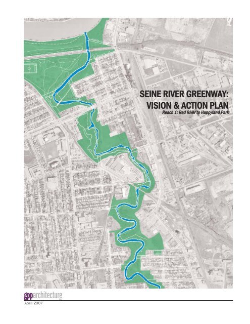
Seine River Greenway: Vision & Action Plan ... - City of Winnipeg
Seine River Greenway: Vision & Action Plan ... - City of Winnipeg
Seine River Greenway: Vision & Action Plan ... - City of Winnipeg

You also want an ePaper? Increase the reach of your titles
YUMPU automatically turns print PDFs into web optimized ePapers that Google loves.
April 2007<br />
SEINE RIVER GREENWAY:<br />
VISION & ACTION PLAN<br />
RReeaacchh 11:: RReedd RRiivveerr ttoo HHaappppyyllaanndd PPaarrkk
Prepared by:<br />
GPP Architecture<br />
Guy Préfontaine<br />
project director and designer<br />
Kevin Clouston<br />
Research and data analysis<br />
Jason Ilagan<br />
graphics and layout<br />
Prepared for:<br />
SEINE RIVER GREENWAY: VISION & ACTION PLAN<br />
Reach 1: Red <strong>River</strong> to Happyland Park<br />
A joint venture between the Save our <strong>Seine</strong> <strong>River</strong><br />
Environment Inc. and the <strong>City</strong> <strong>of</strong> <strong>Winnipeg</strong>.<br />
Following are the consulting members for this<br />
project.<br />
Save Our <strong>Seine</strong> <strong>River</strong> Environment Inc.<br />
David Danyluk<br />
Suzanne Gessler<br />
Jules Legal<br />
<strong>City</strong> <strong>of</strong> <strong>Winnipeg</strong><br />
Donna Beaton<br />
Jason Bell<br />
Rick Enns<br />
Cheryl Heming<br />
Ken McKim<br />
Kevin Nixon<br />
Page 1
Special thanks to:<br />
SEINE RIVER GREENWAY: VISION & ACTION PLAN<br />
Reach 1: Red <strong>River</strong> to Happyland Park<br />
Acknowledgements<br />
The representatives from the various community<br />
groups interested in the preservation and<br />
recreational use <strong>of</strong> the <strong>Seine</strong> <strong>River</strong>.<br />
Community Members from the study area including<br />
Maison Gabrielle-Roy, Entreprise Riel, L’Association<br />
des Résidents du Vieux St. Boniface, Société Franco-<br />
Manitobaine, Prairie Pathfinders, and Festival du<br />
Voyageur<br />
Representatives <strong>of</strong> the community and landowners,<br />
whose properties afront the <strong>Seine</strong> <strong>River</strong> valley, that<br />
attended meetings and provided us with their<br />
valuable comments and feedback.<br />
Page 2
Acknowledgements 2<br />
Table <strong>of</strong> Contents 3<br />
Introduction 4<br />
Methodology 5<br />
Goals, Objectives and Purpose 6<br />
Geographic Location 7<br />
Historic Over View 8<br />
Existing Context 11<br />
Habitat restoration 12<br />
Trails 13<br />
Trail safety 14<br />
<strong>Vision</strong> and action plan; existing conditions 14a<br />
<strong>Vision</strong> and action plan; points <strong>of</strong> interest 14b<br />
Challenges to <strong>Greenway</strong> Habitat 15<br />
Beavers 15<br />
Dutch Elm Disease 16<br />
Invasive Species 16<br />
Development 17<br />
<strong>River</strong>bank Stabilization 17<br />
Water Management 18<br />
<strong>Vision</strong> for <strong>Seine</strong> <strong>River</strong> Valley - Reach 1 19<br />
Focus Area 1 - Lagimodiére-Gaboury Park 20<br />
Focus Area 2 - Gabrielle Roy Park 21<br />
Focus Area 3 - Post Industrial 22<br />
Focus Area 4 - North Marion Street 23<br />
Literature Review 24<br />
Appendix A: Exit Survey Summary;<br />
Final <strong>Vision</strong> and <strong>Action</strong> <strong>Plan</strong><br />
Appendix B: Initial Summary Report<br />
Appendix C: Exist Survey;<br />
Summary <strong>of</strong> Stakeholder Feedback<br />
Appendix D: Exist Survey Collected Responses;<br />
Stakeholder Feedback - Oct 19, 2006<br />
Appendix E: Exist SurveyCollected Responses;<br />
Stakeholder Feedback - Nov 13, 2006<br />
SEINE RIVER GREENWAY: VISION & ACTION PLAN<br />
Reach 1: Red <strong>River</strong> to Happyland Park<br />
Table <strong>of</strong> Contents<br />
Page 3
SEINE RIVER GREENWAY: VISION & ACTION PLAN<br />
Reach 1: Red <strong>River</strong> to Happyland Park<br />
Introduction<br />
GPP Architecture was retained by the <strong>City</strong> <strong>of</strong><br />
<strong>Winnipeg</strong>, in partnership with the community group<br />
Save Our <strong>Seine</strong> to develop a <strong>Vision</strong> and <strong>Action</strong> <strong>Plan</strong><br />
for the portion <strong>of</strong> the <strong>Seine</strong> <strong>River</strong> Corridor, defined as<br />
Reach 1 and stretching from the Red <strong>River</strong> to<br />
Happyland Park. In acknowledgement that the<br />
corridor is more than just the river and its adjacent<br />
banks, past studies have viewed the river corridor as<br />
a <strong>Greenway</strong>. In this way the constituent components<br />
<strong>of</strong> land, water, cultural and natural resources are<br />
considered as interlocking pieces <strong>of</strong> a larger whole,<br />
rather than isolated entities with little connection to<br />
each other.<br />
In its larger context, the <strong>Seine</strong> <strong>River</strong> connects to<br />
many rural communities to that south east <strong>of</strong> the<br />
province, such as Ste. Anne. Within the city proper,<br />
urban development is slowly encroaching on the<br />
<strong>Seine</strong> <strong>River</strong> corridor and threatens to deplete the<br />
natural area. Attention must be given to the unique<br />
character <strong>of</strong> this area and efforts to preserve it<br />
natural state.<br />
The <strong>Seine</strong> <strong>River</strong> <strong>Greenway</strong> provides a unique and<br />
valued “urban wilderness” heritage to local<br />
residents. The action plan, completed in consultation<br />
with local stakeholders, seeks to protect, nurture and<br />
enhance the <strong>Seine</strong> <strong>River</strong> for the enjoyment <strong>of</strong> present<br />
and future generations and prevent exploitation,<br />
destruction and neglect <strong>of</strong> this valuable resource.<br />
According to a 1998 recent survey the <strong>City</strong> <strong>of</strong><br />
<strong>Winnipeg</strong> owns approximately 44% <strong>of</strong> the total<br />
riverbank for that portion <strong>of</strong> the river between the<br />
Red <strong>River</strong> and the diversion at the Red <strong>River</strong><br />
Floodway. This level <strong>of</strong> riverbank ownership has only<br />
increased given recent residential development along<br />
the southern portion <strong>of</strong> the greenway.<br />
This is the first <strong>of</strong> a series <strong>of</strong> planning studies <strong>of</strong> the<br />
parkland, property and neigbourhoods aligning the<br />
<strong>Seine</strong> <strong>River</strong> <strong>Greenway</strong>. Through identification <strong>of</strong><br />
major goals and objectives the <strong>Action</strong> <strong>Plan</strong> will<br />
establish a framework for future development along<br />
the river. This initial study will focus on that portion<br />
<strong>of</strong> the greenway beginning at the mouth along the<br />
Red <strong>River</strong> and extending south to Happyland Park<br />
where the <strong>Seine</strong> crosses Rue Marion. Subsequent<br />
<strong>Vision</strong> and <strong>Action</strong> <strong>Plan</strong>s will build on and extend the<br />
proposed framework for development.<br />
Page 4
The methodology, which was geared to the specific<br />
needs <strong>of</strong> the client and the project, broke the<br />
formation <strong>of</strong> the <strong>Vision</strong> and resulting <strong>Action</strong> <strong>Plan</strong><br />
down into a series <strong>of</strong> clearly defineable stages and<br />
constituent steps. This clearly identifies aspects <strong>of</strong><br />
planning, preparation, set-up, review and reporting<br />
leading to the production <strong>of</strong> the final report.<br />
The <strong>Seine</strong> <strong>River</strong> <strong>Vision</strong> and <strong>Action</strong> <strong>Plan</strong> included the<br />
following stages:<br />
A. Existing Conditions/Review <strong>of</strong> Past Studies<br />
and Current <strong>Plan</strong>s:<br />
• Site Investigation and Assessment <strong>of</strong> existing<br />
conditions, opportunities and constraints within<br />
the study area.<br />
• Interviews with Parks Superintendent and Urban<br />
Designer/Landscape Architect.<br />
• Confirmation <strong>of</strong> priorities with <strong>City</strong> <strong>of</strong> <strong>Winnipeg</strong><br />
and Save Our <strong>Seine</strong> Group (SOS).<br />
• Review <strong>of</strong> <strong>Seine</strong> <strong>River</strong> <strong>Greenway</strong> Study and all<br />
ancillary studies (as many as five identified to<br />
date). Summarize finding and direction from<br />
these. Draw design direction from these and<br />
apply to site mapping in order to create<br />
composite map incorporating the directives<br />
emanating from all previous studies.<br />
• Review <strong>of</strong> upcoming projects that Client group<br />
may be planning (rail bridge improvements,<br />
etc.)<br />
• Prepare and deliver summary report and<br />
preliminary study boards <strong>of</strong> findings.<br />
SEINE RIVER GREENWAY: VISION & ACTION PLAN<br />
Reach 1: Red <strong>River</strong> to Happyland Park<br />
Methodology<br />
B. Stakeholder Consultation:<br />
• Initial meeting(s) with Project Steering<br />
Committee comprised <strong>of</strong> <strong>City</strong> staff and SOS<br />
members to clarify keys steps and deliverables,<br />
identify potential stakeholders and partners and<br />
define stakeholder consultation process. From<br />
this process, at the Client’s suggestion, we may<br />
widen the circle <strong>of</strong> potential development<br />
partners.<br />
• Identify stakeholder groups and identify<br />
appropriate forum to meet groups based upon<br />
level <strong>of</strong> ownership. Interviews and/or focus<br />
group consultation with key resident and nonresident<br />
stakeholders and partners including<br />
S.O.S., Festival du Voyageur, trails/paddling<br />
groups, Old St. Boniface Residents Association,<br />
Enterprise Riel, local area residents, local<br />
businesses/industries backing onto the <strong>Seine</strong><br />
<strong>River</strong>, Maison Gabrielle Roy, etc.<br />
• Interviews/meeting with relevant <strong>City</strong> staff<br />
including, <strong>City</strong> Naturalist, Parks Superintendent,<br />
Waterways Engineer, Urban Designer and others<br />
as defined by the Project Steering Committee.<br />
• Compilation <strong>of</strong> stakeholder feedback and<br />
facilitation <strong>of</strong> additional <strong>Plan</strong>ning/<strong>Vision</strong>ing<br />
Session(s) to confirm key priorities and<br />
opportunities for the <strong>Vision</strong> <strong>Plan</strong>.<br />
• Prepare and deliver summary report and<br />
preliminary study boards <strong>of</strong> findings.<br />
C. <strong>Vision</strong> and <strong>Action</strong> <strong>Plan</strong>:<br />
• Development <strong>of</strong> a comprehensive <strong>Vision</strong> <strong>Plan</strong> for<br />
the study area, based on stakeholder feedback<br />
and direction from the Project Steering<br />
Committee.<br />
• Present same to all stakeholder groups for<br />
feedback. Identify potential development<br />
partners and partnerships.<br />
• Based upon feedback, make final adjustments<br />
to boards, and prepare final documents.<br />
• Meet with the groups and undertake ranking<br />
exercise that will help determine priorities,<br />
schedule, achievability and partnerships.<br />
• Prepare summary report, concept plans and<br />
conceptual sketches as well as list <strong>of</strong> priorities.<br />
Page 5
The purpose <strong>of</strong> the <strong>Vision</strong> is not to provide yet<br />
another study for an area that has been extensively<br />
over-studied. It is to create as consensus driven<br />
document, which represents the will and direction <strong>of</strong><br />
all <strong>of</strong> the affected area stakeholders; be they<br />
government, industry, residents or volunteers that all<br />
have a stake in the sound and progressive<br />
development <strong>of</strong> this highly cherished area. It is not<br />
a list <strong>of</strong> projects that are to be undertaken by the<br />
<strong>City</strong> <strong>of</strong> <strong>Winnipeg</strong>, but rather an open invitation to all<br />
participants to create partnerships that will assure<br />
the longterm stable and sustainable development <strong>of</strong><br />
the area.<br />
These partnerships will champion each project and<br />
find the person-power and funding to see these<br />
projects become a reality. This <strong>Vision</strong> will identify<br />
local champions and be used as a promotional tool<br />
to seek out other funding opportunities.<br />
Goals, Objectives and Purpose<br />
SEINE RIVER GREENWAY: VISION & ACTION PLAN<br />
Reach 1: Red <strong>River</strong> to Happyland Park<br />
Page 6
Red <strong>River</strong><br />
Perimeter<br />
Highway<br />
<strong>Seine</strong><br />
<strong>River</strong><br />
Reach 1<br />
Figure 1. Geographic Location <strong>of</strong> study area and larger <strong>Seine</strong> <strong>River</strong><br />
Valley.<br />
SEINE RIVER GREENWAY: VISION & ACTION PLAN<br />
Reach 1: Red <strong>River</strong> to Happyland Park<br />
Geographic Location<br />
The study area is located east <strong>of</strong> downtown<br />
<strong>Winnipeg</strong>, along the <strong>Seine</strong> <strong>River</strong> Valley in the<br />
neighbourhood <strong>of</strong> St.Boniface. (Fig 1) Beginning in<br />
the north where the <strong>Seine</strong> flows into the Red <strong>River</strong><br />
near Whittier Park the study area extends southward<br />
to Happyland Park where the <strong>Seine</strong> river crosses rue<br />
Marion. Its lateral boundaries are defined by<br />
Archibald to the East and des Meurons to the West.<br />
Though contained within the neighbourhood <strong>of</strong><br />
St.Boniface, the study area includes or touches on<br />
several communities along either side <strong>of</strong> the river.<br />
The <strong>Seine</strong> <strong>River</strong> itself is a slow flowing and<br />
extensively meandering river. Depending on how its<br />
river corridor is treated and “developed” the river can<br />
either connect or divide these communities. Semiformal<br />
walking trails and bike paths currently exist<br />
along portions <strong>of</strong> the backs on either side <strong>of</strong> the<br />
river.<br />
Containing many historic elements, it is rich in<br />
francophone and métis history and culture. The<br />
fastest growing residential community in <strong>Winnipeg</strong> at<br />
present surround the river to the south. Urban<br />
development is slowly encroching on the <strong>Seine</strong> <strong>River</strong><br />
corridor, and threatens to deplete the natural area.<br />
Proposed residential development will soon surround<br />
the river up to the river up to the perimiter.<br />
In its larger context, the <strong>Seine</strong> <strong>River</strong> connects to<br />
many rural communities in the south east <strong>of</strong> the<br />
province, such as Ste. Anne. Many <strong>of</strong> these<br />
communities are studying the potential recreational<br />
aspect <strong>of</strong> the river as tourist lickages to <strong>Winnipeg</strong>. It<br />
is therefore important to keep in mind that the study<br />
area is part <strong>of</strong> a large river valley, both within<br />
<strong>Winnipeg</strong> and southern eastern Manitoba.<br />
Page 7
The <strong>Seine</strong> <strong>River</strong> is an unassuming tributary to the<br />
larger and more well know Red <strong>River</strong>. Its history can<br />
be divided into two periods; pre- and post<br />
settlement. Its river valley traditionally provided an<br />
excellent wildlife habitat because <strong>of</strong> the diverse<br />
environments afforded by it. Prior to settlement in<br />
the area, it had a relative importance as a supplier <strong>of</strong><br />
game for native hunters. Subsequent to settlement<br />
the river valley was exposed to a series <strong>of</strong><br />
interventions. Drainage ditches, bridges, agricultural<br />
cultivation and urban settlement all contributed to<br />
changes to the river basin, the flow <strong>of</strong> the river and<br />
the river itself. The most recent and dramatic <strong>of</strong><br />
these was the construction <strong>of</strong> the Red <strong>River</strong> Floodway<br />
in 1967.<br />
While no significant archeological pre-settlement<br />
sites have been discovered along the river, anecdotal<br />
evidence <strong>of</strong> Aboriginal presence in the area does<br />
exist. In the early part <strong>of</strong> the Nineteenth Century,<br />
lands given to Roman Catholic Church encompassed<br />
the greenway. This was to form the basis <strong>of</strong> the<br />
community that has come to be known as St.<br />
Boniface. As a result several historically and<br />
culturally significant sites, pertaining to early settle<br />
and growth <strong>of</strong> the area, exist adjacent or in close<br />
proximity to the <strong>Seine</strong> <strong>River</strong>; as abundant as those<br />
along the larger Red <strong>River</strong>. The concentration <strong>of</strong><br />
these is higher in the areas <strong>of</strong> the river valley<br />
addressed by the vision than in other portions <strong>of</strong> the<br />
river further upstream to the south. Both individually<br />
and collectively they <strong>of</strong>fer opportunities for<br />
development, transforming the river into a corridor<br />
linking the various heritage resources and re-uniting<br />
individuals with both the past and the river.<br />
SEINE RIVER GREENWAY: VISION & ACTION PLAN<br />
Reach 1: Red <strong>River</strong> to Happyland Park<br />
Historical Overview<br />
For a listing <strong>of</strong> sites along with their specific<br />
locations refer to the Historic Sites Map (map 1).<br />
Some <strong>of</strong> the more noteable <strong>of</strong> these are:<br />
Jean-Baptiste Lagimodiére/Marie-Anne Gaboury<br />
Homestead.<br />
The foundation <strong>of</strong> the Canadien-Métis or<br />
francophone community by the Lagimodieres and<br />
their extended families is strongly identified with the<br />
north end <strong>of</strong> the <strong>Seine</strong> <strong>River</strong> valley in the immediate<br />
vicinity along the <strong>Seine</strong> <strong>River</strong> (Fig. 2). Many <strong>of</strong> their<br />
descendents went on to become farmers and<br />
establish a permanent community along the <strong>Seine</strong><br />
<strong>River</strong>.<br />
Figure 2: Parks Canada plaque installed at the Lagimodiére/Gaboury<br />
Homestead<br />
Page 8
SEINE RIVER GREENWAY: VISION & ACTION PLAN<br />
Reach 1: Red <strong>River</strong> to Happyland Park<br />
Historical Overview<br />
Gabrielle Roy family home (Figure 3)<br />
Considered the first female novelist <strong>of</strong> Québécois<br />
literature, Gabrielle Roy was a writer <strong>of</strong> international<br />
stature and recognition. Her writings immortalized<br />
the rue Deschambault, the street on which she was<br />
born and raised. Her first novel Bohneur d’occasion<br />
earned her France’s prestigious Prix Fémina.<br />
Figure 3. The family home <strong>of</strong> Gabrielle Roy at 375 rue Deschambault<br />
Sacred Heart Belgian Roman Catholic Cemetary<br />
Representative <strong>of</strong> the early pioneers that settled in<br />
the surrounding neighbourhood, the cemetary and<br />
(now demolished) parish church answered the<br />
spiritual needs <strong>of</strong> the Flemish immigrants and their<br />
descendents. The markers within the cemetary<br />
provide a physical record <strong>of</strong> the early Belgian<br />
peoples that arrived in this area.<br />
The areas along both sides <strong>of</strong> the river have<br />
experienced urbanization and development as St.<br />
Boniface and <strong>Winnipeg</strong> grew and expanded. Though<br />
the <strong>Seine</strong> <strong>River</strong> has not been spared from the<br />
negative impacts <strong>of</strong> development, elements <strong>of</strong> its<br />
natural beauty still remain. Rejuvenation <strong>of</strong> this<br />
greenway into a sustainable “urban wilderness”<br />
within the <strong>City</strong> <strong>of</strong> <strong>Winnipeg</strong> remains an achievable<br />
goal. One that if achieved has the potential to<br />
become one <strong>of</strong> the most beautiful and valued<br />
landscapes within the <strong>City</strong> <strong>of</strong> <strong>Winnipeg</strong>. 1<br />
1 <strong>Seine</strong> <strong>River</strong> Study; Final Report <strong>of</strong> <strong>Seine</strong> <strong>River</strong> Task Force, P10<br />
Page 9
SEINE RIVER GREENWAY: VISION & ACTION PLAN<br />
Reach 1: Red <strong>River</strong> to Happyland Park<br />
Historical Sites<br />
Map 1. Historical Sites<br />
Page 10
Ownership <strong>of</strong> the riverbank within the study area<br />
varies considerable. North <strong>of</strong> Provencher, the <strong>City</strong> <strong>of</strong><br />
<strong>Winnipeg</strong> owns almost all <strong>of</strong> the land adjacent to the<br />
river. Though no heritage trees have been identified<br />
in this area, approximately half <strong>of</strong> the land in this<br />
area is considered to be high quality habitat. Five<br />
sites have been identified as Wildlife Enhancement<br />
and Vegetation Restoration Areas. 1 The riverbank<br />
adjacent to the Belgian Club (located along the north<br />
side <strong>of</strong> Provencher) has been negatively impacted by<br />
its parking lot along the river. Previous filling<br />
operations when the land was used for market<br />
gardening have created complex and steep<br />
riverbanks. One major riverbank failure has occurred<br />
in this area. The area hosts nine identifiable historic<br />
sites, <strong>of</strong> which Lagimodière/Gaboury Homestead is<br />
the most notable, in addition to countless others,<br />
related to the settlement’s early history. History<br />
remains a potent source for future development.<br />
South <strong>of</strong> Provencher city ownership <strong>of</strong> riverbank<br />
lands falls to only about 25%. This is entirely<br />
comprised by Kavanagh Park; the only city owned<br />
park in this segment. Large portions on the east side<br />
<strong>of</strong> the river are zoned and occupied by industrial use.<br />
The most notable <strong>of</strong> these is the IKO site, which is<br />
slated for an environmental clean-up affecting both<br />
riverbanks along the site. The remaining lands are<br />
comprised <strong>of</strong> institutional and detached residential<br />
developments. Land use on the westside <strong>of</strong> the river<br />
is similar, thought the percentage <strong>of</strong> residential or<br />
planned residential development is higher. Should<br />
the industrials relocate, new residential<br />
developments are planned for these lands.<br />
Though the majority <strong>of</strong> the riverbank is privately<br />
owned, much <strong>of</strong> this area can be accessed by means<br />
<strong>of</strong> existing un<strong>of</strong>ficial trails. No formal easements at<br />
present exist with the owners <strong>of</strong> these lands. Less<br />
that 10% <strong>of</strong> the riverbank are considered to be <strong>of</strong><br />
high quality habitat. Fifteen Wildlife Enhancement<br />
and Vegetation Restoration areas have been<br />
identified and eight possible heritage trees have been<br />
located. 2 Seven riverbank failures have been<br />
identified and a significant failure at Kavanagh St.<br />
has been rectified.<br />
SEINE RIVER GREENWAY: VISION & ACTION PLAN<br />
Reach 1: Red <strong>River</strong> to Happyland Park<br />
Existing Context<br />
Significant portions <strong>of</strong> the riverbank have been<br />
previously built-up with concrete rubble to allow<br />
greater site development and reduce erosion due to<br />
flooding. As a result <strong>of</strong> S.O.S.’s efforts some <strong>of</strong> these<br />
materials have been removed. Their complete<br />
removal, dependant <strong>of</strong> the available funds, is<br />
essential to improve river navigation and prevent<br />
blockage <strong>of</strong> the river.<br />
For owners <strong>of</strong> riverbank property, their property line<br />
along the shore typically extends the “high<br />
waterline”. Many owners do not know this and<br />
instead believe their property extend all the way<br />
down to the river. The land between the river waters<br />
and there property line is owned by the city. When an<br />
area is being developed for a residential development<br />
the C.O.W. is obligated to buy along the riverbank up<br />
to the high waterline at the set rate <strong>of</strong><br />
$15,000.00/acre. In <strong>Winnipeg</strong>, five to ten acres <strong>of</strong><br />
riverbank properties are acquired every year by the<br />
city through this process.<br />
As previously mentions industrial development along<br />
the <strong>Seine</strong> <strong>River</strong> has damaged or destroyed the<br />
natural habitat. The most notable <strong>of</strong> these within the<br />
current study area is the IKO site located along the<br />
river’s east bank. The site is highly contaminated. An<br />
environmental remediation <strong>of</strong> the site is scheduled<br />
to begin 2007 and will involve both sides <strong>of</strong> the river.<br />
As part <strong>of</strong> this work, the river will experience<br />
significant disruption with the flow <strong>of</strong> the river<br />
temporarily redirected around the remediation area.<br />
This ironically provides a significant opportunity for<br />
upgrading the riverbank.<br />
Many <strong>of</strong> the current river crossings, both vehicular<br />
and pedestrian, interfere with navigation <strong>of</strong> the river.<br />
All new bridges are to conform to new guidelines put<br />
in place by the city. These require all new bridges not<br />
to interfere with recreational navigation <strong>of</strong> the river.<br />
Page 11
HABITAT RESTORATION<br />
As noted above, significant portions <strong>of</strong> high quality<br />
habitat, suitable for supporting wildlife, exist along<br />
portions <strong>of</strong> the river. Preservation <strong>of</strong> these areas and<br />
restoration <strong>of</strong> lands impacted by previous<br />
development are key to the action plan’s success.<br />
The natural habitat will draw local wildlife. These in<br />
turn will be a draw to users; encouraging them to<br />
hike, cycle or canoe the length <strong>of</strong> what will be known<br />
as the <strong>Greenway</strong>.<br />
The success <strong>of</strong> any greenway requires the continuity<br />
<strong>of</strong> the natural habitat along its entire length. Gaps<br />
and breaks in the habitat isolate the greenway into<br />
discreet pockets and prevent or discourage the<br />
migration <strong>of</strong> wildlife along its length. Until recently,<br />
the typical city park was comprised <strong>of</strong> manicured<br />
lawns, clipped hedges and possible addition <strong>of</strong> floral<br />
plantings. This approach eliminated or excluded use<br />
<strong>of</strong> indigenous plant species sought by wildlife. For<br />
this reason the greenway needs to be expanded;<br />
gaps filled in; damaged lands restored.<br />
SEINE RIVER GREENWAY: VISION & ACTION PLAN<br />
Reach 1: Red <strong>River</strong> to Happyland Park<br />
Existing Context<br />
The city has adopted a policy <strong>of</strong> naturalization,<br />
which encourages the planting and return <strong>of</strong> native<br />
grasses, shrubs, trees and wildflowers. In essence,<br />
naturalization encourages the return <strong>of</strong> prairie<br />
grasslands, woodlands or wetlands native to<br />
<strong>Winnipeg</strong>, restoring habitat sought by local wildlife.<br />
Naturalization can be either passive or active.<br />
Passive naturalization returns an area to its natural<br />
state by decreasing or eliminating mowing <strong>of</strong> the<br />
area, allowing the indigenous species to return over<br />
time. Active naturalization is the reintroduction <strong>of</strong><br />
native species into a selected area. To educate the<br />
public concerning the concept the city has produced<br />
some information materials on the subject. It may<br />
need to be expanded or more highly publicised, else<br />
the public may interpret these conditions as a lack<br />
and civic maintenance rather than good<br />
environmental policy.<br />
The width <strong>of</strong> a greenway has an importance similar<br />
to that <strong>of</strong> the continuity along its length. Not all<br />
plants and wildlife require the same habitat width.<br />
For some it can be rather narrow. Others require a<br />
more significant width, without which they cannot<br />
reside in the area regardless <strong>of</strong> the quality <strong>of</strong> the<br />
habitat. The <strong>City</strong> <strong>of</strong> <strong>Winnipeg</strong> has identified the<br />
preferred width <strong>of</strong> the greenway to be 350 feet. In<br />
most cases this cannot be achieved due to existing<br />
development. However, as part <strong>of</strong> the naturalization<br />
process it should be sought wherever possible.<br />
Figure 4. <strong>River</strong> habitat comprised <strong>of</strong> the river, its<br />
immediate riverbanks and the adjacent uplands.<br />
Page 12
TRAILS<br />
A series <strong>of</strong> formal and informal river trails align<br />
portions <strong>of</strong> the study area. These trails are<br />
predominately, though not exclusively, located along<br />
the west side <strong>of</strong> the <strong>Seine</strong> <strong>River</strong>. Both pedestrians<br />
and cyclists utilize the trials, though some <strong>of</strong> the<br />
more isolated sections tend to experience less usage.<br />
The more informal portions <strong>of</strong> the trials, which run<br />
close to the river and tend to be surrounded by<br />
woodlands, need periodic attention to avoid<br />
becoming overgrown. Where this occurs it tends to<br />
preclude use <strong>of</strong> the trials except by for the most<br />
hardy. Such conditions also tend to feed into<br />
concerns about safety, which further discourage use<br />
<strong>of</strong> the trail system. A responsive maintenance<br />
program is important to encourage and promote the<br />
public’s use <strong>of</strong> the trail system. This could be a role<br />
for Save Our <strong>Seine</strong> in the context <strong>of</strong> a regular<br />
maintenance agreement with the <strong>City</strong> <strong>of</strong> <strong>Winnipeg</strong>.<br />
SEINE RIVER GREENWAY: VISION & ACTION PLAN<br />
Reach 1: Red <strong>River</strong> to Happyland Park<br />
Existing Context<br />
The absence <strong>of</strong> trails along the east bank, the limited<br />
number <strong>of</strong> river crossing points and the low level <strong>of</strong><br />
city ownership along the east side generally<br />
precludes public use on this side <strong>of</strong> the river.<br />
Additional river crossing points and obtainment by<br />
the city <strong>of</strong> either ownership or public easements for<br />
additional trails would be required to alter this<br />
situation. Residents along the eastside have been<br />
cool to such suggestions, preferring the isolation <strong>of</strong><br />
their current situation. However this situation also<br />
precludes the residents’ use <strong>of</strong> the trail system to<br />
the west. As the city has already done elsewhere, it<br />
may be possible to renovate the existing railway<br />
bridge at Deschambault to include a pedestrian<br />
crossing. A crossing at this location though removed<br />
from the Tissot and Dufresne enclaves provides an<br />
additional crossing point at the approximate midpoint<br />
between the other existing crossing at<br />
Provencher and Marion.<br />
Pedestrian crossing <strong>of</strong> Provencher, adjacent to where<br />
it meets the <strong>Seine</strong> <strong>River</strong>, is a hazard due to the speed<br />
and volume <strong>of</strong> vehicular traffic along this artery and<br />
discourage potential trial users crossing from one<br />
side to the other. Installation <strong>of</strong> a crosswalk or some<br />
alternative means is required to alleviate this<br />
situation.<br />
Expansion <strong>of</strong> these trails has been proposed by<br />
groups such as Prairie Pathfinder. Expansion would<br />
see the trail system extended along the Red <strong>River</strong> to<br />
Whitter Park and the incorporation <strong>of</strong> winter trails for<br />
cross country skiing, ensuring year round usage.<br />
Connection to the Trans Canada Trial and proposed<br />
bike path along the CPR Marconi line are also being<br />
planned for.<br />
Page 13
SEINE RIVER GREENWAY: VISION & ACTION PLAN<br />
Reach 1: Red <strong>River</strong> to Happyland Park<br />
Existing Context<br />
TRAIL SAFETY<br />
There are two main categories affecting trail safety:<br />
Physical Character and <strong>City</strong> By-laws. Physical<br />
character includes trail surface, grading, trail<br />
maintenance, fencing (need to see through),<br />
entrance and exits, signage and lighting (in terms <strong>of</strong><br />
visibility and admission <strong>of</strong> natural light). Where as<br />
<strong>City</strong> By-laws controls hours <strong>of</strong> use (dusk-til-dawn),<br />
presence <strong>of</strong> open fires, By-law enforcement, and<br />
contact authorities.<br />
For reasons <strong>of</strong> safety, pedestrian and bike trails may<br />
wish to avoid long unbroken and secluded segments,<br />
with limited access points, and blind corners. These<br />
can make users feel vulnerable and discourages their<br />
use <strong>of</strong> the trails. Visual or active supervision <strong>of</strong> the<br />
trials is also a key concern, especially for the<br />
protection <strong>of</strong> female users.<br />
New trails should be located to leave certain areas<br />
(such as river points) undisturbed and instead<br />
provide small spur lines in place <strong>of</strong> the main trail<br />
through these areas. This can help to improve site<br />
lines for users, which also improves safety.<br />
Lighting along trails and related areas is a key<br />
consideration with respect to user safety. Fixture<br />
selection and lighting levels need careful<br />
consideration. Light fixtures need to be durable and<br />
resistant to vandalism. Illumination levels need to be<br />
high enough for user safety, but not so bright as to<br />
scare away wildlife.<br />
1 <strong>Seine</strong> <strong>River</strong> Study; Final Report <strong>of</strong> <strong>Seine</strong> <strong>River</strong> Task Force,<br />
P55<br />
2 Ibid, P58<br />
Page 14
<strong>Seine</strong> <strong>River</strong> <strong>Greenway</strong>: <strong>Vision</strong> and <strong>Action</strong> <strong>Plan</strong><br />
SEINE RIVER GREENWAY: VISION & ACTION PLAN<br />
Reach 1: Red <strong>River</strong> to Happyland Park<br />
Reach 1: Red <strong>River</strong> to Happyland Park<br />
Page 14a
<strong>Seine</strong> <strong>River</strong> <strong>Greenway</strong>: <strong>Vision</strong> and <strong>Action</strong> <strong>Plan</strong><br />
SEINE RIVER GREENWAY: VISION & ACTION PLAN<br />
Reach 1: Red <strong>River</strong> to Happyland Park<br />
Reach 1: Red <strong>River</strong> to Happyland Park<br />
Page 14b
Challenges to <strong>Greenway</strong> Habitat<br />
SEINE RIVER GREENWAY: VISION & ACTION PLAN<br />
Reach 1: Red <strong>River</strong> to Happyland Park<br />
The <strong>Seine</strong> <strong>River</strong> <strong>Greenway</strong> is faced by a variety <strong>of</strong><br />
challenges, both nature and man-made, which<br />
threaten the health and sustainability <strong>of</strong> the river, its<br />
adjacent riverbanks and immediate uplands. Each <strong>of</strong><br />
these <strong>of</strong>fers unique and serious challenges to the<br />
long-term health and sustainability <strong>of</strong> the river.<br />
Where possible some initial steps have been taken,<br />
however more is required to adequately address the<br />
threats posed.<br />
Beavers<br />
It is estimated at present there are between 50-100<br />
beavers along the <strong>Seine</strong> <strong>River</strong> <strong>Greenway</strong>. The absence<br />
<strong>of</strong> natural predators from the area has removed<br />
natural checks and balances on the beaver<br />
population, allowing it to continue to grow. The<br />
current beaver population in the greenway takes a<br />
heavy toll on the mature trees lining the banks <strong>of</strong> the<br />
river, which are felled by them for construction <strong>of</strong><br />
their dams and dens. The problem this poses is<br />
significant and rated from moderate to high in<br />
importance with respect the success and health <strong>of</strong><br />
the greenway.<br />
The canopies <strong>of</strong> mature trees in addition to providing<br />
shade and habitat for other animals in the greenway,<br />
help to stabilize the riverbanks and protect it from<br />
erosion. Removal <strong>of</strong> large numbers <strong>of</strong> mature trees<br />
therefore negatively impacts the greenway and the<br />
animal habitat it can provide. <strong>Plan</strong>ting <strong>of</strong> new young<br />
trees, though important, does not immediately<br />
make-up for the loss <strong>of</strong> older mature trees. This can<br />
only be remedied by time.<br />
Wrapping the base <strong>of</strong> trees with stucco wire is an<br />
effective means <strong>of</strong> protecting them against beavers.<br />
Community volunteers have undertaken the<br />
wrapping <strong>of</strong> older mature trees; approximately one<br />
hundred fifty have been wrapped so far. An audit <strong>of</strong><br />
the area’s trees is needed to identify those <strong>of</strong><br />
significance requiring immediate protection.<br />
However, given the overall length <strong>of</strong> the <strong>Seine</strong> <strong>River</strong><br />
<strong>Greenway</strong> and the number <strong>of</strong> trees that would need<br />
to be wrapped, this is not a practical solution to the<br />
problem. Simply dismantling beaver dams is no<br />
solution either. Rather it causes the destruction <strong>of</strong><br />
additional trees as beavers construct new dams. An<br />
updated estimate on the beaver population is<br />
required for an accurate picture on the extent <strong>of</strong> the<br />
problem. At present removal <strong>of</strong> beavers through<br />
discrete trapping is the only effective <strong>of</strong> alleviating<br />
this problem.<br />
Page 15
Dutch Elm disease is a concern to the viability <strong>of</strong> the greenway.<br />
Purple Loosestrife (Lythrum) replaces all native vegetation and<br />
destroys wetlands areas.<br />
Challenges to <strong>Greenway</strong> Habitat<br />
SEINE RIVER GREENWAY: VISION & ACTION PLAN<br />
Reach 1: Red <strong>River</strong> to Happyland Park<br />
Dutch Elm Disease<br />
Dutch elm disease is a major environmental concern<br />
for the greenway. Though chemical treatments do<br />
exist for protecting uninfected trees, these are<br />
expensive and difficult to administer on a large scale.<br />
At present, there is no treatment or cure for trees<br />
infected with the disease. Removal <strong>of</strong> infected wood<br />
is the only means <strong>of</strong> addressing the problem. Early<br />
detection <strong>of</strong> infection is therefore critical to<br />
containing the spread <strong>of</strong> the disease. Preventative<br />
measures such as tree banding by volunteers has<br />
been carried out in the past. To be effective such<br />
measures require an on going effort, both for the<br />
banding <strong>of</strong> trees in mid-September and removal <strong>of</strong><br />
the bands in mid-May. The city <strong>of</strong> <strong>Winnipeg</strong> has<br />
assisted through the public information campaigns.<br />
Reliance on volunteers for on going tree banding may<br />
prove problematic as the greenway expands in size.<br />
Invasive Species<br />
The preservation and restoration <strong>of</strong> existing natural<br />
habitat is challenged by invasive species, such as<br />
Purple Loosestrife and European Buckthorn. As they<br />
are foreign to the region, there are no native insects<br />
to check their advance. The hardiness <strong>of</strong> such<br />
species typically makes it difficult, though not<br />
impossible, to eradicate them from infected areas<br />
once they become established. Where public<br />
resource are not available, local volunteers can be<br />
used to respond these problems. The <strong>City</strong> <strong>of</strong><br />
<strong>Winnipeg</strong> and Ducks Unlimited Canada have<br />
published information pamphlets to make groups<br />
aware both <strong>of</strong> the problem and the proper corrective<br />
approaches.<br />
European Buckthorn has taken over large tracks <strong>of</strong> riparian forest.<br />
Page 16
Challenges to <strong>Greenway</strong> Habitat<br />
SEINE RIVER GREENWAY: VISION & ACTION PLAN<br />
Reach 1: Red <strong>River</strong> to Happyland Park<br />
Development<br />
New development along the greenway needs to be<br />
carried out in such a way as to avoid further damage<br />
to river habitat. Where new development along the<br />
river must occur, it needs to be done as sensitively as<br />
possible and should ideally take place on previously<br />
developed lands. In this way the potential negative<br />
impact is minimized.<br />
<strong>River</strong>bank Stabilization<br />
Several locations within the current study area and<br />
along the length <strong>of</strong> the greenway show signs <strong>of</strong><br />
riverbank failure. This is a result <strong>of</strong> natural erosion <strong>of</strong><br />
the bank over time. <strong>River</strong>bank restoration efforts are<br />
involve and expensive undertakings. Efforts to<br />
stabilize the riverbank against failure have been<br />
undertaken by means <strong>of</strong> active tree planting<br />
programs.<br />
Page 17
Figure 5: The stone structures <strong>of</strong> riffles act like dams, making a<br />
higher water level upstream <strong>of</strong> the structure.<br />
Figure 6: Although water is squeezed through the stone riffles, they<br />
allows fish to pass up or down stream.<br />
Challenges to <strong>Greenway</strong> Habitat<br />
SEINE RIVER GREENWAY: VISION & ACTION PLAN<br />
Reach 1: Red <strong>River</strong> to Happyland Park<br />
Water Management<br />
Maintaining a minimal water level in the <strong>Seine</strong> <strong>River</strong><br />
for navigation by canoes and small boats is<br />
problematic at present. The diversion <strong>of</strong> waters<br />
from the <strong>Seine</strong> <strong>River</strong> Basin for economic<br />
development and local flooding protection has<br />
negatively impacted the river’s water level and<br />
quality. During years with low precipitation the river<br />
running dry and river habitat and fish populations<br />
suffer. The diversion <strong>of</strong> water largely takes place<br />
outside <strong>of</strong> the city, beyond the jurisdiction <strong>of</strong> the<br />
municipal government. Efforts to change existing<br />
diversions require support from the provincial<br />
government and need to be pursued if the water<br />
conditions in the river are to be further improved.<br />
The community group Save Our <strong>Seine</strong>, with the<br />
support <strong>of</strong> government, has organized the<br />
construction <strong>of</strong> riffles in the river in response to this<br />
situation. (Fig. 5) Riffles are artificial stone<br />
structures that act as dams and mimic the effect <strong>of</strong><br />
rapids. (Fig. 6) In this way they help to raise river<br />
water levels, dissolve oxygen into the water and<br />
provide a continuous migration route for fish. (Fig. 7)<br />
The deeper pools <strong>of</strong> water created by the riffles have<br />
lower water temperatures creating better fish<br />
habitat. Expansion <strong>of</strong> the riffle system is to proceed<br />
as resources become available. Save Our <strong>Seine</strong> has<br />
also proposed nine additional artificial spawning<br />
beds for the improvement <strong>of</strong> subsurface habitat.<br />
Figure 7: By disturbing the surface <strong>of</strong> the river, riffles add dissolved<br />
oxygen to the water.<br />
Page 18
<strong>Seine</strong> <strong>River</strong> <strong>Greenway</strong>: <strong>Vision</strong> & <strong>Action</strong> <strong>Plan</strong><br />
SEINE RIVER GREENWAY: VISION & ACTION PLAN<br />
Reach 1: Red <strong>River</strong> to Happyland Park<br />
Reach 1: Red <strong>River</strong> to Happyland Park<br />
Page 19
<strong>Seine</strong> <strong>River</strong> <strong>Greenway</strong>: <strong>Vision</strong> & <strong>Action</strong> <strong>Plan</strong><br />
Reach 1: Focus Area 1 - Lagimodiere-Gaboury Park<br />
SEINE RIVER GREENWAY: VISION & ACTION PLAN<br />
Reach 1: Red <strong>River</strong> to Happyland Park<br />
Page 20
<strong>Seine</strong> <strong>River</strong> <strong>Greenway</strong>: <strong>Vision</strong> & <strong>Action</strong> <strong>Plan</strong><br />
SEINE RIVER GREENWAY: VISION & ACTION PLAN<br />
Reach 1: Red <strong>River</strong> to Happyland Park<br />
Reach 1: Focus Area 2 - Gabrielle Roy Park<br />
Page 21
<strong>Seine</strong> <strong>River</strong> <strong>Greenway</strong>: <strong>Vision</strong> & <strong>Action</strong> <strong>Plan</strong><br />
SEINE RIVER GREENWAY: VISION & ACTION PLAN<br />
Reach 1: Red <strong>River</strong> to Happyland Park<br />
Reach 1: Focus Area 3 - Post Industrial<br />
Page 22
<strong>Seine</strong> <strong>River</strong> <strong>Greenway</strong>: <strong>Vision</strong> & <strong>Action</strong> <strong>Plan</strong><br />
SEINE RIVER GREENWAY: VISION & ACTION PLAN<br />
Reach 1: Red <strong>River</strong> to Happyland Park<br />
Reach 1: Focus Area 4 - North Marion Street<br />
Page 23
Publications; Studies:<br />
<strong>River</strong>bank Stability Characterization Study <strong>of</strong> the<br />
<strong>Seine</strong> <strong>River</strong> in <strong>Winnipeg</strong>, MB (1994)<br />
An assessment <strong>of</strong> Vegetation and Wildlife Habitat<br />
Quality for the SEINE RIVER PARKWAY (1995)<br />
The <strong>Seine</strong> <strong>River</strong> Corridor: its history and<br />
suggestions for its interpretation (1995)<br />
Hydrological and Hydraulic Modeling <strong>of</strong> Flows and<br />
Levels <strong>of</strong> the <strong>Seine</strong> <strong>River</strong>. (1996)<br />
<strong>Seine</strong> <strong>River</strong> Study; Final Report <strong>of</strong> <strong>Seine</strong> <strong>River</strong> Task<br />
force (1998)<br />
<strong>Seine</strong> <strong>River</strong> <strong>Greenway</strong> Study, (2000)<br />
<strong>Seine</strong> <strong>River</strong> Stability Characterization, (1994)<br />
An assessment <strong>of</strong> vegetation and wildlife habitat<br />
quality for the <strong>Seine</strong> <strong>River</strong> Parkway, (1995)<br />
Hydrological and hydraulic modeling <strong>of</strong> flows and<br />
levels <strong>of</strong> the <strong>Seine</strong> <strong>River</strong> (1996)<br />
<strong>Seine</strong> <strong>River</strong> Interpretive Trail; A feasibility and<br />
design study, (1995)<br />
<strong>Seine</strong> <strong>River</strong> Park Study, (1980)<br />
Bois des Esprits Park <strong>Plan</strong>, (2001)<br />
IPEG 2020 <strong>Vision</strong>, <strong>City</strong> <strong>of</strong> <strong>Winnipeg</strong><br />
Lagimodière-Gaboury Homestead; Master <strong>Plan</strong> and<br />
First Phase <strong>of</strong> Development (1999)<br />
Crime prevention through environmental design,<br />
<strong>City</strong> <strong>of</strong> Victoria, Amended 2004<br />
Publications; InformationPamphlets:<br />
Dutch Elm Disease, Province <strong>of</strong> Manitoba<br />
European Buckthorn, <strong>City</strong> <strong>of</strong> <strong>Winnipeg</strong><br />
Health tips for Healthy Streams, Government <strong>of</strong><br />
Canada<br />
Purple Loosestrife in Western Canada, Ducks<br />
Unlimited Canada<br />
Tree Banding, <strong>City</strong> <strong>of</strong> <strong>Winnipeg</strong><br />
SEINE RIVER GREENWAY: VISION & ACTION PLAN<br />
Reach 1: Red <strong>River</strong> to Happyland Park<br />
Literature Review<br />
Books:<br />
How Parkways Work: A Handbook on Ecology by<br />
Janathan Labaree, 1992<br />
Websites:<br />
How <strong>Greenway</strong>s Work:<br />
www.americantrails.org<br />
<strong>City</strong> <strong>of</strong> <strong>Winnipeg</strong>; Public Works – Naturalization in<br />
<strong>Winnipeg</strong>:<br />
www.winnipeg.ca/publicworks/parks/Naturalization.asp<br />
Waterfront Living; Safeguard your Health and<br />
Wealth:<br />
www.livingbywater.ca<br />
National Trials training Partnership:<br />
www.americantrails.org/resources/greenways/NPSintro<br />
Grnwy.html<br />
Save Our <strong>Seine</strong>:<br />
www.saveourseine.com<br />
Manitoba Clean Water Guide; Manitoba:<br />
Environment Water Quality Management Section.<br />
www.gov.mb.ca/waterstewardship/index.html?water_gui<br />
de/toc.html<br />
Page 24
Appendix A:<br />
Exit Survey Summary; Final <strong>Vision</strong> and <strong>Action</strong> <strong>Plan</strong><br />
SEINE RIVER GREENWAY: VISION & ACTION PLAN<br />
Reach 1: Red <strong>River</strong> to Happyland Park
Below is the summary <strong>of</strong> the opinions and preferences expressed with regard to the questions<br />
asked<br />
Which projects are <strong>of</strong> most interest to you? (indicate by title, board or item number)?<br />
(x1) 1.2 Splash-Dash Water Taxi<br />
(x1) 1.3 Lagimodière-Gaboury Interpretive Park<br />
(x2) 2.1 Provencher Pedestrian Crossing<br />
(x1) 2.2 Place de la Culture<br />
(x1) 2.3 Provencher Canoe Launch<br />
(x5) 2.4 Gabrielle Roy Theme Park<br />
(x2) 3.1 Pedestrian Crossing Bridge<br />
(x2) 3.2 Low Impact Permanent Trail System<br />
(x2) 3.3 Preserve & Rehabilitate naturalized Habitat<br />
(x1) 3.4 Post Industrial Housing Infill<br />
(x3) 4.2 Marion Street Canoe Launch<br />
Do you have any concerns with any <strong>of</strong> the projects proposed? If so, which ones and why?<br />
(x1) 2.4 Suitable portal & parking for Gabrielle-Roy Park<br />
(x1) 2.5 Encroachment <strong>of</strong> Residential Development<br />
(x3) 3.1Proper consultation process critical, needs resolution through stakeholders working<br />
together, unspecific crossing siting<br />
Proper access for canoes & kayaks<br />
Consistent, unique and aesthetically pleasing signage<br />
Developing long and short-term <strong>Vision</strong> <strong>Plan</strong><br />
What would be your three most important projects for implementation in the 2007 construction season?<br />
(x1) 1.2 Splash-Dash Water Taxi<br />
(x2) 1.3 Lagimodière-Gaboury Interpretive Perk<br />
(x2) 2.1 Provencher Pedestrian Crossing<br />
(x3) 2.3 Provencher Canoe Launch<br />
(x5) 2.4 Gabrielle-Roy Theme Park<br />
(x2) 3.1 Pedestrian Bridge Crossing<br />
(x1) 3.2 Low Impact Permanent Walking Trail System<br />
(x4) 4.2 Marion Street Canoe Launch<br />
SEINE RIVER GREENWAY: VISION & ACTION PLAN<br />
Reach 1: Red <strong>River</strong> to Happyland Park
How would/could you like to see yourself or your group participating in the projects that you have<br />
priorized? Have you planned to contribute labour, or funds to the project?<br />
Dufresne Residents Group – Dufresne Residents Brief – Contribute labour.<br />
Maison Gabrielle-Roy – Literary Path & Park development – Can contribute funds granted through<br />
<strong>Winnipeg</strong> Foundation to completing Business <strong>Plan</strong>. Future funding for built elements may be<br />
forthcoming.<br />
Northern Soul Wilderness Adventures – Various Canoe Projects – Can contribute knowledge, input<br />
for paddlers, design for boat launches.<br />
Save Our <strong>Seine</strong> – various Projects along <strong>Seine</strong> – Can contribute Fundraising and funds, expertise &<br />
knowledge, promotion <strong>of</strong> events, activities & initiatives.<br />
Do you have any ongoing or proposed projects that should be considered within this <strong>Vision</strong> plan?<br />
Dufresne Residents Group – see Dufresne Residents Brief submitted to <strong>City</strong> <strong>of</strong> <strong>Winnipeg</strong><br />
Maison Gabrielle Roy – G-R literary walking tour in St-Boniface should be part pf <strong>Vision</strong><br />
SOS – IKO site restoration & dirt bike jumping park at Lagimodière-Gaboury Park<br />
SEINE RIVER GREENWAY: VISION & ACTION PLAN<br />
Reach 1: Red <strong>River</strong> to Happyland Park
Appendix B:<br />
<strong>Seine</strong> <strong>River</strong> <strong>Greenway</strong>: Reach 1; Summary Report<br />
SEINE RIVER GREENWAY: VISION & ACTION PLAN<br />
Reach 1: Red <strong>River</strong> to Happyland Park
Introduction<br />
Goals and Objectives<br />
Methodology<br />
Findings Summary<br />
Historic over view <strong>of</strong> <strong>Seine</strong> <strong>River</strong> Study Area<br />
Existing Context<br />
Habitat restoration<br />
Trails<br />
Trail Safety<br />
Existing Challenges to <strong>Greenway</strong> Habitat<br />
Beavers<br />
Dutch Elm Disease<br />
Invasive Species<br />
Development<br />
<strong>River</strong>bank Stabilization<br />
Water Management<br />
Opportunities for Development<br />
Glossary<br />
Literature Review<br />
List <strong>of</strong> Stakeholders<br />
SEINE RIVER GREENWAY: VISION & ACTION PLAN<br />
Reach 1: Red <strong>River</strong> to Happyland Park<br />
Table <strong>of</strong> Contents
GPP Architecture was retained by the <strong>City</strong> <strong>of</strong><br />
<strong>Winnipeg</strong>, on behalf <strong>of</strong> the community group Save<br />
Our <strong>Seine</strong> to develop a <strong>Vision</strong> and <strong>Action</strong> <strong>Plan</strong> for the<br />
portion <strong>of</strong> the <strong>Seine</strong> <strong>River</strong> Corridor, defined as Reach<br />
1 and stretching from the Red <strong>River</strong> to Happyland<br />
Park. In acknowledgement that the corridor is more<br />
than just the river and its adjacent banks, past<br />
studies have viewed the river corridor as a <strong>Greenway</strong>.<br />
In this way the constituent components <strong>of</strong> land,<br />
water, cultural and natural resources are considered<br />
as interlocking pieces <strong>of</strong> a larger whole, rather than<br />
isolated entities with little connection to each other.<br />
The <strong>Seine</strong> <strong>River</strong> <strong>Greenway</strong> provides a unique and<br />
valued “urban wilderness” heritage to local<br />
residents. The action plan to be completed, in<br />
consultation with local stakeholders, will seek to<br />
protect, nurture and enhance the <strong>Seine</strong> <strong>River</strong> for the<br />
enjoyment <strong>of</strong> present and future generations and<br />
prevent exploitation, destruction and neglect <strong>of</strong> this<br />
valuable resource.<br />
According to a 1998 recent survey the <strong>City</strong> <strong>of</strong><br />
<strong>Winnipeg</strong> owns approximately 44% <strong>of</strong> the total<br />
riverbank for that portion <strong>of</strong> the river between the<br />
Red <strong>River</strong> and the diversion at the Red <strong>River</strong><br />
Floodway. This level <strong>of</strong> riverbank ownership has only<br />
increased given recent residential development along<br />
the southern portion <strong>of</strong> the greenway.<br />
This is the first <strong>of</strong> a series <strong>of</strong> planning studies <strong>of</strong> the<br />
parkland, property and neigbourhoods aligning the<br />
<strong>Seine</strong> <strong>River</strong> <strong>Greenway</strong>. Through identification <strong>of</strong><br />
major goals and objectives the <strong>Action</strong> <strong>Plan</strong> will<br />
construct a framework for future development along<br />
the river. This initial study will focus on that portion<br />
<strong>of</strong> the greenway beginning at the mouth along the<br />
Red <strong>River</strong> and extending south to Happyland Park<br />
where the <strong>Seine</strong> crosses Rue Marion. Subsequent<br />
<strong>Vision</strong> and <strong>Action</strong> <strong>Plan</strong>s will build on and extend the<br />
proposed framework for development.<br />
GOALS AND OBJECTIVES<br />
The ultimate goal <strong>of</strong> the immediate study is to<br />
enhance the connection from Whitter Park, at the<br />
river’s mouth, to Happyland Park to the south. Initial<br />
development will establish a heart for the overall<br />
project that will be extended overtime.<br />
Develop next a “kit <strong>of</strong> parts” that can be used with<br />
subsequent phases <strong>of</strong> the planning study to tie the<br />
entire <strong>Vision</strong> together. This is the key to creating this<br />
connection.<br />
Putting in place measures and strategies that<br />
counter existing threats (both natural and manmade)<br />
to the natural habitat along the river.<br />
Fostering a sustainable natural landscape, with plant<br />
species natural to the region.<br />
Striking a balance between the needs <strong>of</strong> people,<br />
plants and wildlife along the river. To mutually<br />
enriched and attract people and economic<br />
development while ensuring a natural habitat and<br />
cultural landscape <strong>of</strong><br />
generations.<br />
high quality for future<br />
METHODOLOGY<br />
SEINE RIVER GREENWAY: VISION & ACTION PLAN<br />
Reach 1: Red <strong>River</strong> to Happyland Park<br />
Introduction<br />
As a prelude to more extensive public and<br />
stakeholder consultation a preliminary information<br />
gathering exercise was conducted, drawing on<br />
previous studies and available base information for<br />
the area in question as well as through interviews<br />
with key representatives from Save Our <strong>Seine</strong> and the<br />
<strong>City</strong> <strong>of</strong> <strong>Winnipeg</strong>.<br />
The process included identification <strong>of</strong> project goals<br />
and objectives, gathering <strong>of</strong> topological, typological<br />
and hydrological information and identification <strong>of</strong><br />
potential stakeholders and partners (from the public<br />
and private sectors).<br />
A summary <strong>of</strong> the findings from this process was<br />
assembled from which preliminary study boards<br />
were created. These were used to reconfirm the<br />
findings and direction with the key representatives.<br />
What follows is a summary report <strong>of</strong> the collected<br />
findings.
HISTORIC OVER VIEW OF SEINE RIVER STUDY AREA<br />
The <strong>Seine</strong> <strong>River</strong> is an unassuming tributary to the<br />
larger and more well know Red <strong>River</strong>. The <strong>Seine</strong> <strong>River</strong><br />
valley traditionally provided an excellent wildlife<br />
habitat because <strong>of</strong> the diversity <strong>of</strong> environment it<br />
afforded. Prior to settlement in the area, it had a<br />
relative importance as a supplier <strong>of</strong> game for native<br />
hunters. Subsequent to settlement the river valley<br />
was exposed to a series <strong>of</strong> interventions. Drainage<br />
ditches, bridges, agricultural cultivation and urban<br />
settlement all contributed to changes to the river<br />
basin, the flow <strong>of</strong> the river and the river itself. The<br />
most recent and dramatic <strong>of</strong> these was the<br />
construction <strong>of</strong> the Red <strong>River</strong> Floodway in 1967.<br />
While no significant archeological pre-settlement<br />
sites have been discovered along the river, anecdotal<br />
evidence <strong>of</strong> Aboriginal presence in the area does<br />
exist. In the early part <strong>of</strong> the Nineteenth Century,<br />
lands given to Roman Catholic Church encompassed<br />
the greenway. This was to form the basis <strong>of</strong> the<br />
community that has come to be known as St.<br />
Boniface. As a result several historically and<br />
culturally significant sites, pertaining to early settle<br />
and growth <strong>of</strong> the area, exist adjacent or in close<br />
proximity to the <strong>Seine</strong> <strong>River</strong>. The concentration <strong>of</strong><br />
these is higher in the areas addressed by the current<br />
study than in other portions further upstream. They<br />
<strong>of</strong>fer opportunities for development, re-uniting<br />
individuals with both the past and the river.<br />
The areas along both sides <strong>of</strong> the river have<br />
experienced urbanization and development as St.<br />
Boniface and <strong>Winnipeg</strong> grew and expanded. Though<br />
the <strong>Seine</strong> <strong>River</strong> has not been spared from the<br />
negative impacts <strong>of</strong> development, elements <strong>of</strong> its<br />
natural beauty still remain. Rejuvenation <strong>of</strong> this<br />
greenway into a sustainable “urban wilderness”<br />
within the <strong>City</strong> <strong>of</strong> <strong>Winnipeg</strong> remains an achievable<br />
goal. One that if achieved has the potential to<br />
become one <strong>of</strong> the most beautiful and valued<br />
landscapes within the <strong>City</strong> <strong>of</strong> <strong>Winnipeg</strong>. 1<br />
EXISTING CONTEXT<br />
Ownership <strong>of</strong> the riverbank within the study area<br />
varies considerable. North <strong>of</strong> Provencher, the <strong>City</strong> <strong>of</strong><br />
<strong>Winnipeg</strong> owns almost all <strong>of</strong> the land adjacent to the<br />
river. Though no heritage trees have been identified<br />
in this area, approximately half <strong>of</strong> the land in this<br />
area is considered to be high quality habitat. Five<br />
sites have been identified as Wildlife Enhancement<br />
and Vegetation Restoration Areas. 2 The riverbank<br />
SEINE RIVER GREENWAY: VISION & ACTION PLAN<br />
Reach 1: Red <strong>River</strong> to Happyland Park<br />
Findings Summary<br />
adjacent to the Belgian Club (located along the north<br />
side <strong>of</strong> Provencher) has been negatively impacted by<br />
its parking lot along the river. Previous filling<br />
operations when the land was used for market<br />
gardening have created complex and steep<br />
riverbanks. One major riverbank failure has occurred<br />
in this area. The area hosts nine identifiable historic<br />
sites, <strong>of</strong> which Lagimodière/Gaboury Homestead is<br />
the most notable, in addition to countless others,<br />
related to the settlement’s early history. History<br />
remains a potent source for future development.<br />
South <strong>of</strong> Provencher city ownership <strong>of</strong> riverbank<br />
lands falls to only about 25%. This is entirely<br />
comprised by Kavanagh Park; the only city owned<br />
park in this segment. Large portions on the east side<br />
<strong>of</strong> the river are zoned and occupied by industrial use.<br />
The most notable <strong>of</strong> these is the IKO site, which is<br />
slated for an environmental clean-up affecting both<br />
riverbanks along the site. The remaining lands are<br />
comprised <strong>of</strong> institutional and detached residential<br />
developments. Land use on the westside <strong>of</strong> the river<br />
is similar, thought the percentage <strong>of</strong> residential or<br />
planned residential development is higher. Should<br />
the industrials relocate, new residential<br />
developments are planned for these lands.<br />
Though the majority <strong>of</strong> the riverbank is privately<br />
owned, much <strong>of</strong> this area can be accessed by means<br />
<strong>of</strong> existing un<strong>of</strong>ficial trails. No formal easements at<br />
present exist with the owners <strong>of</strong> these lands. Less<br />
that 10% <strong>of</strong> the riverbank are considered to be <strong>of</strong><br />
high quality habitat. Fifteen Wildlife Enhancement<br />
and Vegetation Restoration areas have been<br />
identified and eight possible heritage trees have been<br />
located. 3 Seven riverbank failures have been<br />
identified and a significant failure at Kavanagh St.<br />
has been rectified.<br />
Significant portions <strong>of</strong> the riverbank have been<br />
previously built-up with concrete rubble to allow<br />
greater site development and reduce erosion due to<br />
flooding. As a result <strong>of</strong> S.O.S.’s efforts some <strong>of</strong> these<br />
materials have been removed. Their complete<br />
removal, dependant <strong>of</strong> the available funds, is<br />
essential to improve river navigation and prevent<br />
blockage <strong>of</strong> the river.<br />
For owners <strong>of</strong> riverbank property, their property line<br />
along the shore typically extends the “high<br />
waterline”. Many owners do not know this and<br />
instead believe their property extend all the way<br />
down to the river. The land between the river waters
and there property line is owned by the city. When an<br />
area is being developed for a residential development<br />
the C.O.W. is obligated to buy along the riverbank up<br />
to the high waterline at the set rate <strong>of</strong><br />
$15,000.00/acre. In <strong>Winnipeg</strong>, five to ten acres <strong>of</strong><br />
riverbank properties are acquired every year by the<br />
city through this process.<br />
As previously mentions industrial development along<br />
the <strong>Seine</strong> <strong>River</strong> has damaged or destroyed the<br />
natural habitat. The most notable <strong>of</strong> these within the<br />
current study area is the IKO site located along the<br />
river’s east bank. The site is highly contaminated. An<br />
environmental remediation <strong>of</strong> the site is scheduled<br />
to begin 2007 and will involve both sides <strong>of</strong> the river.<br />
As part <strong>of</strong> this work, the river will experience<br />
significant disruption with the flow <strong>of</strong> the river<br />
temporarily redirected around the remediation area.<br />
This ironically provides a significant opportunity for<br />
upgrading the riverbank.<br />
Many <strong>of</strong> the current river crossings, both vehicular<br />
and pedestrian, interfere with navigation <strong>of</strong> the river.<br />
All new bridges are to conform to new guidelines put<br />
in place by the city. These require all new bridges not<br />
to interfere with recreational navigation <strong>of</strong> the river.<br />
HABITAT RESTORATION<br />
As noted above, significant portions <strong>of</strong> high quality<br />
habitat, suitable for supporting wildlife, exist along<br />
portions <strong>of</strong> the river. Preservation <strong>of</strong> these areas and<br />
restoration <strong>of</strong> lands impacted by previous<br />
development are key to the action plan’s success.<br />
The natural habitat will draw local wildlife. These in<br />
turn will be a draw to users; encouraging them to<br />
hike, cycle or canoe the length <strong>of</strong> what will be known<br />
as the <strong>Greenway</strong>.<br />
The success <strong>of</strong> any greenway requires the continuity<br />
<strong>of</strong> the natural habitat along its entire length. Gaps<br />
and breaks in the habitat isolate the greenway into<br />
discreet pockets and prevent or discourage the<br />
migration <strong>of</strong> wildlife along its length. Until recently,<br />
the typical city park was comprised <strong>of</strong> manicured<br />
lawns, clipped hedges and possible addition <strong>of</strong> floral<br />
plantings. This approach eliminated or excluded use<br />
<strong>of</strong> indigenous plant species sought by wildlife. For<br />
this reason the greenway needs to be expanded;<br />
gaps filled in; damaged lands restored.<br />
The city has adopted a policy <strong>of</strong> naturalization,<br />
which encourages the planting and return <strong>of</strong> native<br />
grasses, shrubs, trees and wildflowers. In essence,<br />
naturalization encourages the return <strong>of</strong> prairie<br />
grasslands, woodlands or wetlands native to<br />
<strong>Winnipeg</strong>, restoring habitat sought by local wildlife.<br />
Naturalization can be either passive or active.<br />
Passive naturalization returns an area to its natural<br />
state by decreasing or eliminating mowing <strong>of</strong> the<br />
area, allowing the indigenous species to return over<br />
time. Active naturalization is the reintroduction <strong>of</strong><br />
native species into a selected area. To educate the<br />
public concerning the concept the city has produced<br />
some information materials on the subject. It may<br />
need to be expanded or more highly publicised, else<br />
the public may interpret these conditions as a lack<br />
and civic maintenance rather than good<br />
environmental policy.<br />
The width <strong>of</strong> a greenway has an importance similar<br />
to that <strong>of</strong> the continuity along its length. Not all<br />
plants and wildlife require the same habitat width.<br />
For some it can be rather narrow. Others require a<br />
more significant width, without which they cannot<br />
reside in the area regardless <strong>of</strong> the quality <strong>of</strong> the<br />
habitat. The <strong>City</strong> <strong>of</strong> <strong>Winnipeg</strong> has identified the<br />
preferred width <strong>of</strong> the greenway to be 350 feet. In<br />
most cases this cannot be achieved due to existing<br />
development. However, as part <strong>of</strong> the naturalization<br />
process it should be sought wherever possible.<br />
TRAILS<br />
SEINE RIVER GREENWAY: VISION & ACTION PLAN<br />
Reach 1: Red <strong>River</strong> to Happyland Park<br />
A series <strong>of</strong> formal and informal river trails align<br />
portions <strong>of</strong> the study area. These trails are<br />
predominately, though not exclusively, located along<br />
the west side <strong>of</strong> the <strong>Seine</strong> <strong>River</strong>. Both pedestrians<br />
and cyclists utilize the trials, though some <strong>of</strong> the<br />
more isolated sections tend to experience less usage.<br />
The more informal portions <strong>of</strong> the trials, which run<br />
close to the river and tend to be surrounded by<br />
woodlands, need periodic attention to avoid<br />
becoming overgrown. Where this occurs it tends to<br />
preclude use <strong>of</strong> the trials except by for the most<br />
hardy. Such conditions also tend to feed into<br />
concerns about safety, which further discourage use<br />
<strong>of</strong> the trail system. A responsive maintenance<br />
program is important to encourage and promote the<br />
public’s use <strong>of</strong> the trail system. This could be a role<br />
for Save Our <strong>Seine</strong> in the context <strong>of</strong> a regular<br />
maintenance agreement with the <strong>City</strong> <strong>of</strong> <strong>Winnipeg</strong>.<br />
The absence <strong>of</strong> trails along the east bank, the limited<br />
number <strong>of</strong> river crossing points and the low level <strong>of</strong><br />
city ownership along the east side generally<br />
precludes public use on this side <strong>of</strong> the river.<br />
Additional river crossing points and obtainment by<br />
the city <strong>of</strong> either ownership or public easements for
additional trails would be required to alter this<br />
situation. Residents along the eastside have been<br />
cool to such suggestions, preferring the isolation <strong>of</strong><br />
their current situation. However this situation also<br />
precludes the residents’ use <strong>of</strong> the trail system to<br />
the west. As the city has already done elsewhere, it<br />
may be possible to renovate the existing railway<br />
bridge at Deschambault to include a pedestrian<br />
crossing. A crossing at this location though removed<br />
from the Tissot and Dufresne enclaves provides an<br />
additional crossing point at the approximate midpoint<br />
between the other existing crossing at<br />
Provencher and Marion.<br />
Pedestrian crossing <strong>of</strong> Provencher, adjacent to where<br />
it meets the <strong>Seine</strong> <strong>River</strong>, is a hazard due to the speed<br />
and volume <strong>of</strong> vehicular traffic along this artery and<br />
discourage potential trial users crossing from one<br />
side to the other. Installation <strong>of</strong> a crosswalk or some<br />
alternative means is required to alleviate this<br />
situation.<br />
Expansion <strong>of</strong> these trails has been proposed by<br />
groups such as Prairie Pathfinder. Expansion would<br />
see the trail system extended along the Red <strong>River</strong> to<br />
Whitter Park and the incorporation <strong>of</strong> winter trails for<br />
cross country skiing, ensuring year round usage.<br />
Connection to the Trans Canada Trial and proposed<br />
bike path along the CPR Marconi line are also being<br />
planned for.<br />
TRAIL SAFETY<br />
There are two main categories affecting trail safety:<br />
Physical Character and <strong>City</strong> By-laws. Physical<br />
character includes trail surface, grading, trail<br />
maintenance, fencing (need to see through),<br />
entrance and exits, signage and lighting (in terms <strong>of</strong><br />
visibility and admission <strong>of</strong> natural light). Where as<br />
<strong>City</strong> By-laws controls hours <strong>of</strong> use (dusk-til-dawn),<br />
presence <strong>of</strong> open fires, By-law enforcement, and<br />
contact authorities.<br />
For reasons <strong>of</strong> safety, pedestrian and bike trails may<br />
wish to avoid long unbroken and secluded segments,<br />
with limited access points, and blind corners. These<br />
can make users feel vulnerable and discourages their<br />
use <strong>of</strong> the trails. Visual or active supervision <strong>of</strong> the<br />
trials is also a key concern, especially for the<br />
protection <strong>of</strong> female users.<br />
New trails should be located to leave certain areas<br />
(such as river points) undisturbed and instead<br />
provide small spur lines in place <strong>of</strong> the main trail<br />
through these areas. This can help to improve site<br />
SEINE RIVER GREENWAY: VISION & ACTION PLAN<br />
Reach 1: Red <strong>River</strong> to Happyland Park<br />
lines for users, which also improves safety.<br />
Lighting along trails and related areas is a key<br />
consideration with respect to user safety. Fixture<br />
selection and lighting levels need careful<br />
consideration. Light fixtures need to be durable and<br />
resistant to vandalism. Illumination levels need to be<br />
high enough for user safety, but not so bright as to<br />
scare away wildlife.
The <strong>Seine</strong> <strong>River</strong> <strong>Greenway</strong> is faced by a variety <strong>of</strong><br />
challenges, both nature and man-made, which<br />
threaten the health and sustainability <strong>of</strong> the river, its<br />
adjacent riverbanks and immediate uplands. Each <strong>of</strong><br />
these <strong>of</strong>fers unique and serious challenges to the<br />
long-term health and sustainability <strong>of</strong> the river.<br />
Where possible some initial steps have been taken,<br />
however more is required to adequately address the<br />
threats posed.<br />
Beavers<br />
It is estimated at present there are between 50-100<br />
beavers along the <strong>Seine</strong> <strong>River</strong> <strong>Greenway</strong>. The absence<br />
<strong>of</strong> natural predators from the area has removed<br />
natural checks and balances on the beaver<br />
population, allowing it to continue to grow. The<br />
current beaver population in the greenway takes a<br />
heavy toll on the mature trees lining the banks <strong>of</strong> the<br />
river, which are felled by them for construction <strong>of</strong><br />
their dams and dens. The problem this poses is<br />
significant and rated from moderate to high in<br />
importance with respect the success and health <strong>of</strong><br />
the greenway.<br />
The canopies <strong>of</strong> mature trees in addition to providing<br />
shade and habitat for other animals in the greenway,<br />
help to stabilize the riverbanks and protect it from<br />
erosion. Removal <strong>of</strong> large numbers <strong>of</strong> mature trees<br />
therefore negatively impacts the greenway and the<br />
animal habitat it can provide. <strong>Plan</strong>ting <strong>of</strong> new young<br />
trees, though important, does not immediately<br />
make-up for the loss <strong>of</strong> older mature trees. This can<br />
only be remedied by time.<br />
Wrapping the base <strong>of</strong> trees with stucco wire is an<br />
effective means <strong>of</strong> protecting them against beavers.<br />
Community volunteers have undertaken the<br />
wrapping <strong>of</strong> older mature trees; approximately one<br />
hundred fifty have been wrapped so far. An audit <strong>of</strong><br />
the area’s trees is needed to identify those <strong>of</strong><br />
significance requiring immediate protection.<br />
However, given the overall length <strong>of</strong> the <strong>Seine</strong> <strong>River</strong><br />
<strong>Greenway</strong> and the number <strong>of</strong> trees that would need<br />
to be wrapped, this is not a practical solution to the<br />
problem. Simply dismantling beaver dams is no<br />
solution either. Rather it causes the destruction <strong>of</strong><br />
additional trees as beavers construct new dams. An<br />
updated estimate on the beaver population is<br />
required for an accurate picture on the extent <strong>of</strong> the<br />
problem. At present removal <strong>of</strong> beavers through<br />
discrete trapping is the only effective <strong>of</strong> alleviating<br />
this problem.<br />
Existing Challenges to <strong>Greenway</strong> Habitat<br />
SEINE RIVER GREENWAY: VISION & ACTION PLAN<br />
Reach 1: Red <strong>River</strong> to Happyland Park<br />
Dutch Elm Disease<br />
Dutch elm disease is a major environmental concern<br />
for the greenway. Though chemical treatments do<br />
exist for protecting uninfected trees, these are<br />
expensive and difficult to administer on a large scale.<br />
At present, there is no treatment or cure for trees<br />
infected with the disease. Removal <strong>of</strong> infected wood<br />
is the only means <strong>of</strong> addressing the problem. Early<br />
detection <strong>of</strong> infection is therefore critical to<br />
containing the spread <strong>of</strong> the disease. Preventative<br />
measures such as tree banding by volunteers has<br />
been carried out in the past. To be effective such<br />
measures require an on going effort, both for the<br />
banding <strong>of</strong> trees in mid-September and removal <strong>of</strong><br />
the bands in mid-May. The city <strong>of</strong> <strong>Winnipeg</strong> has<br />
assisted through the public information campaigns.<br />
Reliance on volunteers for on going tree banding may<br />
prove problematic as the greenway expands in size.<br />
Invasive Species<br />
The preservation and restoration <strong>of</strong> existing natural<br />
habitat is challenged by invasive species, such as<br />
Purple Loosestrife and European Buckthorn. As they<br />
are foreign to the region, there are no native insects<br />
to check their advance. The hardiness <strong>of</strong> such<br />
species typically makes it difficult, though not<br />
impossible, to eradicate them from infected areas<br />
once they become established. Where public<br />
resource are not available, local volunteers can be<br />
used to respond these problems. The <strong>City</strong> <strong>of</strong><br />
<strong>Winnipeg</strong> and Ducks Unlimited Canada have<br />
published information pamphlets to make groups<br />
aware both <strong>of</strong> the problem and the proper corrective<br />
approaches.<br />
Development<br />
New development along the greenway needs to be<br />
carried out in such a way as to avoid further damage<br />
to river habitat. Where new development along the<br />
river must occur, it needs to be done as sensitively as<br />
possible and should ideally take place on previously<br />
developed lands. In this way the potential negative<br />
impact is minimized.<br />
<strong>River</strong>bank Stabilization<br />
Several locations within the current study area and<br />
along the length <strong>of</strong> the greenway show signs <strong>of</strong><br />
riverbank failure. This is a result <strong>of</strong> natural erosion <strong>of</strong><br />
the bank over time. <strong>River</strong>bank restoration efforts are<br />
involve and expensive undertakings. Efforts to<br />
stabilize the riverbank against failure have been
undertaken by means <strong>of</strong> active tree planting<br />
programs.<br />
Water Management<br />
Maintaining a minimal water level in the <strong>Seine</strong> <strong>River</strong><br />
for navigation by canoes and small boats is<br />
problematic at present. The diversion <strong>of</strong> waters from<br />
the <strong>Seine</strong> <strong>River</strong> Basin for economic development and<br />
local flooding protection has negatively impacted the<br />
river’s water level and quality. During years with low<br />
precipitation the river running dry and river habitat<br />
and fish populations suffer. The diversion <strong>of</strong> water<br />
largely takes place outside <strong>of</strong> the city, beyond the<br />
jurisdiction <strong>of</strong> the municipal government. Efforts to<br />
change existing diversions require support from the<br />
provincial government.<br />
The community group Save Our <strong>Seine</strong>, with the<br />
support <strong>of</strong> government, has organized the<br />
construction <strong>of</strong> riffles in the river in response to this<br />
situation. Riffles are artificial stone structures that<br />
act as dams and mimic the effect <strong>of</strong> rapids. In this<br />
way they help to raise river water levels, dissolve<br />
oxygen into the water and provide a continuous<br />
migration route for fish. The deeper pools <strong>of</strong> water<br />
created by the riffles have lower water temperatures<br />
for better fish habitat. Expansion <strong>of</strong> the riffle system<br />
is to proceed as resources become available. Save<br />
Our <strong>Seine</strong> has also proposed nine additional artificial<br />
spawning beds for the improvement <strong>of</strong> subsurface<br />
habitat.<br />
SEINE RIVER GREENWAY: VISION & ACTION PLAN<br />
Reach 1: Red <strong>River</strong> to Happyland Park
All <strong>Vision</strong>s and <strong>Action</strong> <strong>Plan</strong>s rely on the interest and<br />
involvement <strong>of</strong> stakeholders and the building<br />
momentum to realize its implementation. The sooner<br />
a vision garners interest and support, the sooner it is<br />
likely to achieve completion. The same can be<br />
expected for the <strong>Seine</strong> <strong>River</strong> <strong>Greenway</strong>. It is<br />
important to identify and capitalize on opportunities<br />
to attract stakeholder interest. The <strong>Seine</strong> <strong>River</strong><br />
<strong>Greenway</strong> in general and the area <strong>of</strong> Old St. Boniface<br />
addressed by the current study in particular <strong>of</strong>fer<br />
some unique opportunities to do so.<br />
Every February Old St. Boniface plays host to the<br />
Festival du Voyageur winter festival. Outdoor events<br />
for the festival are typically focused around Fort<br />
Gibraltar’s facilities in Whittier Park, west <strong>of</strong> the<br />
<strong>Seine</strong> greenway, along the Red <strong>River</strong>. Select festival<br />
events held along or adjacent to the greenway, such<br />
as the annual dog sled races, could serve to raise<br />
public awareness <strong>of</strong> its presence and interest in its<br />
sustainability and development.<br />
St. Boniface has historically been home to the city’s<br />
Franco-Manitoban community, pre-dating the <strong>City</strong> <strong>of</strong><br />
<strong>Winnipeg</strong> in its current entity. The community’s<br />
coming Bicentennial will <strong>of</strong>fer an opportunity to<br />
highlight the presence <strong>of</strong> St. Boniface within<br />
<strong>Winnipeg</strong> and spotlight the unique qualities <strong>of</strong> the<br />
greenway, especially at its intersection with the<br />
commercial strip <strong>of</strong> Boulevard Provencher.<br />
Mention has also already been made <strong>of</strong> the presence<br />
<strong>of</strong> several culturally and historically significant sites<br />
along the greenway. The most notable <strong>of</strong> which is the<br />
Parc Lagimodière Gaboury. These sites <strong>of</strong>fer<br />
potential points <strong>of</strong> departure for future development<br />
<strong>of</strong> park and interpretive facilities. Visitors drawn to<br />
them may then explore and appreciate the beauty <strong>of</strong><br />
the <strong>Seine</strong> <strong>River</strong>.<br />
An additional opportunity exists where lands are in<br />
the hands <strong>of</strong> industrial owners. The possibility <strong>of</strong><br />
approaching such owners to discuss th potential <strong>of</strong><br />
their selling their lands along the riverbank to the<br />
city should be examined further. Should these<br />
business choose to relocate sometime in the future<br />
selling <strong>of</strong> these lands for residential development<br />
would be a natural outcome. By the selling <strong>of</strong> this<br />
land to the city, these landowners may realize<br />
savings in property tax and insurance premiums. As<br />
these lands enter into the city’s possession, the size<br />
and continuity <strong>of</strong> the public reserve along the river<br />
increases, making the creation <strong>of</strong> established trails<br />
along the river more achievable.<br />
Opportunities for Development<br />
SEINE RIVER GREENWAY: VISION & ACTION PLAN<br />
Reach 1: Red <strong>River</strong> to Happyland Park
Save Our <strong>Seine</strong><br />
A community based stewardship group whose<br />
mandate is to protect, preserve and enhance the<br />
<strong>Seine</strong> <strong>River</strong> Environment within the <strong>City</strong> <strong>of</strong> <strong>Winnipeg</strong><br />
<strong>Greenway</strong><br />
A linear open space connecting parks, nature<br />
preserves, and cultural and historical sites with each<br />
other, and with developed, populated areas. The<br />
greenway may contain formal elements to provide<br />
alternative transportation routes for pedestrians and<br />
bicyclists, or it may be total undeveloped.<br />
Naturalization<br />
The process <strong>of</strong> encouraging a landscape to return to<br />
natural state-prairie grasslands, wildflowers,<br />
wetlands and forests native to its region.<br />
SEINE RIVER GREENWAY: VISION & ACTION PLAN<br />
Reach 1: Red <strong>River</strong> to Happyland Park<br />
Glossary
List <strong>of</strong> reports, studies, publications and websites<br />
reviewed as part <strong>of</strong> the information gathering<br />
process:<br />
<strong>Seine</strong> <strong>River</strong> <strong>Greenway</strong> Study, 2000<br />
<strong>Seine</strong> <strong>River</strong> Stability Characterization, 1994<br />
Hydrological and hydraulic modeling <strong>of</strong> flows and<br />
levels <strong>of</strong> the <strong>Seine</strong> <strong>River</strong>, 1996<br />
An assessment <strong>of</strong> vegetation and wildlife habitat<br />
quality for the <strong>Seine</strong> <strong>River</strong> Parkway, 1995<br />
<strong>Seine</strong> <strong>River</strong> Interpretive Trail; A feasibility and<br />
design study, 1995<br />
<strong>Seine</strong> <strong>River</strong> Park Study, 1980<br />
Bois des Esprits Park <strong>Plan</strong>, 2001<br />
IPEG 2020 <strong>Vision</strong>, <strong>City</strong> <strong>of</strong> <strong>Winnipeg</strong>,<br />
Crime prevention through environmental design,<br />
<strong>City</strong> <strong>of</strong> Victoria, Amended 2004<br />
<strong>City</strong> <strong>of</strong> <strong>Winnipeg</strong>; Public Works – Naturalization in<br />
<strong>Winnipeg</strong><br />
www.winnipeg.ca/publicworks/parks/Naturalization.asp<br />
Waterfront Living; Safeguard your Health and Wealth<br />
www.livingbywater.ca<br />
National Trials training Partnership<br />
www.americantrails.org/resources/greenways/NPSintroGr<br />
nwy.html<br />
Save Our <strong>Seine</strong><br />
www.saveourseine.com<br />
SEINE RIVER GREENWAY: VISION & ACTION PLAN<br />
Reach 1: Red <strong>River</strong> to Happyland Park<br />
Literature Review<br />
Pamphlets:<br />
Dutch Elm Disease, Province <strong>of</strong> Manitoba<br />
European Buckthorn, <strong>City</strong> <strong>of</strong> <strong>Winnipeg</strong><br />
Health tips for Healthy Streams, Government <strong>of</strong><br />
Canada<br />
Purple Loosestrife in Western Canada, Ducks<br />
Unlimited Canada<br />
Tree Banding, <strong>City</strong> <strong>of</strong> <strong>Winnipeg</strong>
The following is a list <strong>of</strong> organizations and<br />
governmental departments identified as<br />
stakeholders that will be asked to feedback as part <strong>of</strong><br />
the <strong>Vision</strong> process used to formulate an <strong>Action</strong> <strong>Plan</strong>.<br />
PRINCIPAL STAKEHOLDERS<br />
Save Our <strong>Seine</strong><br />
<strong>City</strong> <strong>of</strong> <strong>Winnipeg</strong>:<br />
<strong>Plan</strong>ning, Property and Development Dept<br />
Water and Waste Dept.<br />
<strong>River</strong>bank Management Dept<br />
<strong>City</strong> Forestry Dept.<br />
<strong>City</strong> Naturalist<br />
Parks and Recreation<br />
Comm Services Dept. – Splash Dash Water Taxi<br />
Government Representatives (Federal, Provincial and<br />
Municipal)<br />
St. Boniface Residents Association<br />
ADDITIONAL STAKEHOLDERS<br />
SEINE RIVER GREENWAY: VISION & ACTION PLAN<br />
Reach 1: Red <strong>River</strong> to Happyland Park<br />
List <strong>of</strong> Stakeholders<br />
Festival du Voyageur;<br />
Entreprises Riel;<br />
CDEM;<br />
IKO;<br />
Societe-Franco-Manitobaine;<br />
Union nationale métisse Saint-Joseph du Manitoba;<br />
Belgian Club<br />
Norwood Grove Biz<br />
Masion Grabielle Roy<br />
<strong>Winnipeg</strong> Trial Association<br />
Prairie Pathfinders<br />
Paddle Manitoba<br />
Marion School<br />
Northern Soul Wilderness Adventure<br />
<strong>Winnipeg</strong> Urban Angler Partnership<br />
Manitoba Organization <strong>of</strong> Disc Sports<br />
Shakespeare in the Ruins
Appendix C:<br />
Exit Survey; Summary <strong>of</strong> Stakeholder Feedback<br />
SEINE RIVER GREENWAY: VISION & ACTION PLAN<br />
Reach 1: Red <strong>River</strong> to Happyland Park
Strengths <strong>of</strong> the <strong>Seine</strong> <strong>River</strong> <strong>Greenway</strong> (attributes, features, etc)<br />
Nature: High quality riparian environment within urban setting<br />
Diverse animal and plant life<br />
Improved cleanliness<br />
Trails: Ideal walking/hiking paths<br />
Promotes physical activity and family participation<br />
Scenic commute to downtown<br />
History Rich in French-Canadian and Metis Culture<br />
Water ActivityCanoeing<br />
Weaknesses <strong>of</strong> the <strong>Seine</strong> <strong>River</strong> <strong>Greenway</strong> (what is lacking to meet its potential)<br />
Pollution: Open sewers<br />
Raw sewage<br />
Garbage Contamination/litter<br />
Restricted areas Too much private property restricting access to river (C.O.W. to purchase)<br />
Disjointed trail system (nimby)<br />
No safe rail crossings<br />
Not enough river crossing points<br />
Not enough portals to trail system/river access<br />
Water Levels Low levels<br />
Not completely navigateable - Mapping<br />
Stagnant<br />
Lack <strong>of</strong> awareness Presence unknown<br />
Safety Inadequate lighting (trails) (nodes)<br />
Needs “Blue Light” panic alarm<br />
Encourage users – use mile marker postings (Orient and locate)<br />
Presence <strong>of</strong> homeless<br />
Opportunities <strong>of</strong> the <strong>Seine</strong> <strong>River</strong> <strong>Greenway</strong> (what elements need to be developed)<br />
Festival du Voyaguer Integrated into winter activities/festivities<br />
History/Culture Trails could contribute to French Canadian interpretation<br />
Link to major Franco-Manitobain sites (Cathedral,<br />
Maison Gabrielle Roy)<br />
Integrate more Belgian-Manitoban history<br />
Bridges Unite communities across river<br />
Improve water levels and flow<br />
Trails Improve access (portals)<br />
Preservation <strong>of</strong> natural elements<br />
Improve trail quality<br />
Better lighting<br />
Link to other trail systems and to the forks<br />
Rickshaw service<br />
Bonfire pits in formal parks on a site-by-site consideration basis (where to get wood supply)<br />
SEINE RIVER GREENWAY: VISION & ACTION PLAN<br />
Reach 1: Red <strong>River</strong> to Happyland Park
Threats to the <strong>Seine</strong> <strong>River</strong> <strong>Greenway</strong> (given its sensitive nature, what are the threats or harms that need o<br />
be addressed or that will need to be considered in future development)?<br />
Development Industrial – right to water<br />
Commercial – Trucking<br />
Residential – excessive human traffic<br />
Water Floodway diverts too much <strong>of</strong> the waterflow<br />
Low water levels<br />
Flooding<br />
Lack <strong>of</strong> money & commitment<br />
Pollution Raw sewage<br />
Crime Vandalism<br />
Vagrancy (loitering/partying/living in woods)<br />
Assault & robberies<br />
Which issue <strong>of</strong> the project are <strong>of</strong> particular significance to you?<br />
Trails Long and connected<br />
Accessibility (portals)<br />
Signage<br />
<strong>River</strong> crossings<br />
Safe rail crossings<br />
Safety (crime-prevention)<br />
Floodway Improved water flow<br />
History Represent Belgian history<br />
Link to Ft Gibralter & Old St. Boniface<br />
NatureNaturalization <strong>of</strong> developments<br />
Protection <strong>of</strong> habitat & ecosystem<br />
Clean-up<br />
Canoeing<br />
Residential development<br />
Which items have not been addressed and need to be incorporated into the research?<br />
Crossing Provencher Bvld.<br />
Floodway effects<br />
Waterflow & levels<br />
Accessibility<br />
Naturalization<br />
Signage<br />
Belgian History<br />
Link to Ft. Gibraltar, Old St. Boniface & the Forks<br />
<strong>Greenway</strong> promotion<br />
Sewage Pollution<br />
Clean-up <strong>of</strong> industrial waste<br />
NIMBY<br />
Canker worm infestation (no budget – do not do control in natural areas; do not manipulate<br />
wildlifecycle; no spraying along the river)<br />
SEINE RIVER GREENWAY: VISION & ACTION PLAN<br />
Reach 1: Red <strong>River</strong> to Happyland Park
Which initiative that you are aware <strong>of</strong> should be incorporated into the research<br />
Dog friendly areas so animals are not destroying habitat<br />
Link between East & West side <strong>of</strong> river<br />
Portal behind IGA<br />
Which projects does your group have in planning that should be incorporated into this study<br />
Discover the <strong>Seine</strong> in the Winter Hike (10-15 km) – Jan 13, 07 from Hindu Centre, St. Annes Rd<br />
Preservation/Improvement <strong>of</strong> waterflow<br />
Designated bond fire area<br />
Vehicular access<br />
SEINE RIVER GREENWAY: VISION & ACTION PLAN<br />
Reach 1: Red <strong>River</strong> to Happyland Park
Appendix D:<br />
Exit Survey Collected Responses; Stakeholder Feedback<br />
October 19, 2006 <strong>Vision</strong> Session<br />
SEINE RIVER GREENWAY: VISION & ACTION PLAN<br />
Reach 1: Red <strong>River</strong> to Happyland Park
Respondants:<br />
PP: Prairie Pathfinders Inc., Susan Leathers – 284-1652<br />
Res.Duf: Resident-Dufresne, Will Milne – 233-3150/wmilne@mts.net<br />
SOSsg: Save Our <strong>Seine</strong>, Suzanne Gessler – 284-7670 suzannegessler@hotmail.com<br />
SOSdv : Save Our <strong>Seine</strong>, David D. Venema – 256-0341<br />
SOSdd: Save Our <strong>Seine</strong>, Denis DePape – dadepapi@mts.net<br />
SOSsdg : Save Our <strong>Seine</strong>, Sandy Gessler – 256-9205<br />
SOStr: Save Our <strong>Seine</strong>, Tammy Rutherford – 254-5766<br />
Strengths <strong>of</strong> the <strong>Seine</strong> <strong>River</strong> <strong>Greenway</strong> (attributes, features, etc)<br />
PP<br />
Scale: Small river, very sheltered<br />
Perfect winter walkway<br />
Res-Duf<br />
Viable Habitat for preservation/restoration<br />
SOSsg<br />
French Canadian culture<br />
nature in an urban environment (flora & fauna)<br />
Gets individuals & families active and interested in becoming stewards<br />
SOSdd<br />
High quality riparian area<br />
Paths along <strong>Seine</strong><br />
Proximity to historic St. Boniface<br />
Centre <strong>of</strong> Belgian Manitoba history<br />
Gaboury-Lagimodier Park<br />
Important sites in Metis History<br />
SOSsdg<br />
Contribution to human health, mental & physical<br />
Nice natural beauty<br />
Area for walking, hiking<br />
Wildlife appreciation<br />
SOStr:<br />
Natural habitat – feeling <strong>of</strong> being in the middle <strong>of</strong> nowhere<br />
Weaknesses <strong>of</strong> the <strong>Seine</strong> <strong>River</strong> <strong>Greenway</strong> (what is lacking to meet its potential)<br />
PP<br />
Open storm sewers<br />
Gaps: where private lands are not open to the public<br />
SOSsg<br />
Low water, pollution, developments that do not respect the greenway<br />
SOSdv<br />
Too much private property restricting continuation <strong>of</strong> trail<br />
SOSdd<br />
Lack <strong>of</strong> crossing across the river to Archibald<br />
Unsafe rail crossing<br />
No portal to path south <strong>of</strong> Marion<br />
Lack <strong>of</strong> awareness <strong>of</strong> this area in <strong>Winnipeg</strong><br />
SEINE RIVER GREENWAY: VISION & ACTION PLAN<br />
Reach 1: Red <strong>River</strong> to Happyland Park
SOStr:<br />
Sewage run<strong>of</strong>f – garbage contamination etc. – needs cleaning<br />
Continuation <strong>of</strong> trails<br />
Waterway not completely navigateable<br />
Opportunities <strong>of</strong> the <strong>Seine</strong> <strong>River</strong> <strong>Greenway</strong> (what elements need to be developed)<br />
PP<br />
Winter parkway that could be used by Festival du Voyaguer<br />
SOSsg<br />
<strong>Plan</strong>s should contribute to the “French Quarter”<br />
Trails play up the French Canadian culture<br />
Beautiful Bridges<br />
SOSdv<br />
Water levels to be controlled<br />
SOSdd<br />
Interpret history <strong>of</strong> Belgians in Manitoba, this is the main area where Belgians settled in <strong>Winnipeg</strong> –<br />
Belgian Club, Belgian Church Graveyard, Houses on Desautels<br />
Link to key Franco-Manitoban sites on Cathedrale, Maison Gabrielle –Roy<br />
<strong>River</strong> crossing around George Forest<br />
SOSsdg<br />
Historic Sites<br />
Natural features<br />
Trail access points<br />
SOStr:<br />
Trails<br />
Walking bridge<br />
Canoe route (unobstructed)<br />
Threats to the <strong>Seine</strong> <strong>River</strong> <strong>Greenway</strong> (given its sensitive nature, what are the threats or harms that need to be<br />
addressed or that will need to be considered in future development)<br />
Res.Duf<br />
Development / Industrial Impacts<br />
SOSsg<br />
Developments that threaten the river (residential, commercial, industrial & institutional)<br />
NIMBY<br />
SOSdv<br />
The flow <strong>of</strong> the river too much water being diverted from it’s headwaters<br />
Syphon at floodway limits levels has been repaired. SOS wanted all wter to flow through. Change it back<br />
and you just get more floodwater events – not raised seasonal levels.<br />
Golf courses pumping irrigation water from <strong>Seine</strong> <strong>River</strong> to greens.<br />
SOSdd<br />
Industrial development right to water<br />
Trucking businesses on Plinquet<br />
Bank failure<br />
Lack <strong>of</strong> funding to develop needed paths, portals, safety measures<br />
SOSsdg<br />
Many: Lack <strong>of</strong> money and commitment<br />
Waterflow problems<br />
SEINE RIVER GREENWAY: VISION & ACTION PLAN<br />
Reach 1: Red <strong>River</strong> to Happyland Park
SOStr:<br />
PVW (Pembina Valley Water Diversion)/Floodway<br />
Which issue <strong>of</strong> the project are <strong>of</strong> particular significance to you?<br />
PP<br />
Long connected pathways<br />
SOSsg<br />
Protecting habitat – work with the river & greenway<br />
SOSdd<br />
Pedestrian river crossing<br />
Path portals<br />
Making rail area crossing safer<br />
350 acre zone for riparian habitat<br />
Connecting Whittier Park to Happyland Park through trail network<br />
SOSsdg<br />
Walking paths<br />
Preservation <strong>of</strong> eco-system<br />
SOStr:<br />
Keeping the <strong>Greenway</strong> as natural as possible<br />
Acquiring riverbank<br />
Safety<br />
Which items have not been addressed and need to be incorporated into the research?<br />
PP<br />
Passage along the <strong>Seine</strong> under the Provencher Bridge<br />
SOSsg<br />
Impact <strong>of</strong> the floodway<br />
NIMBY<br />
Accessibility<br />
Naturalization <strong>of</strong> developments so they do not affect the greenway<br />
Signage<br />
SOSdd<br />
Belgian history<br />
Link to Fort Gibraltar & Old St. Boniface historic area<br />
SOSsdg<br />
How to promote the greenway after it is developed so it is used well and in a non-destructive way<br />
SOStr:<br />
Clean up <strong>of</strong> what appears to be old industrial waste <strong>of</strong> dumping – ie. oil drums<br />
Which initiative that you are aware <strong>of</strong> should be incorporated into the research?<br />
SOSsg<br />
Dog friendly areas so animals aren’t destroying habitat<br />
SOSdd<br />
New link between east & west side <strong>of</strong> river<br />
Portal behind IGA<br />
SEINE RIVER GREENWAY: VISION & ACTION PLAN<br />
Reach 1: Red <strong>River</strong> to Happyland Park
Which projects does your group have in planning that should be incorporated into this study?<br />
PP<br />
January 13, 2007 “Discover the <strong>Seine</strong> in the Winter Hike” hike from Hindu Centre on St, Annes Rd.<br />
10-15 km<br />
SOSsg<br />
All (or most <strong>of</strong> our projects have the potential to impact this planning)<br />
SOSsdg<br />
Preservation/improvement <strong>of</strong> waterflow<br />
SEINE RIVER GREENWAY: VISION & ACTION PLAN<br />
Reach 1: Red <strong>River</strong> to Happyland Park
Appendix E:<br />
Exit Survey Collected Responses; Stakeholder Feedback<br />
November 13, 2006 <strong>Vision</strong> Session<br />
SEINE RIVER GREENWAY: VISION & ACTION PLAN<br />
Reach 1: Red <strong>River</strong> to Happyland Park
Respondants:<br />
ADRrr: Association des Résidents du Vieux Saint-Boniface, Robert Roy – 233-3616<br />
ADRbl: Association des Résidents du Vieux Saint-Boniface, Bob Lafremere<br />
ADReb: Association des Résidents du Vieux Saint-Boniface, Erin Bockstael<br />
– erinbocks@gmail.com<br />
ADRtf: Association des Résidents du Vieux Saint-Boniface, Theressa Francois – 233-1825<br />
DM : Denis Marion – 237-6636<br />
Misc: (Unsigned)<br />
Strengths <strong>of</strong> the <strong>Seine</strong> <strong>River</strong> <strong>Greenway</strong> (attributes, features, etc)<br />
ADReb<br />
Opportunity for residents for physical activity<br />
Quality <strong>of</strong> life<br />
Can allow residents to walk all the way downtown<br />
Beautiful natural Area<br />
ADRtf<br />
Abundance <strong>of</strong> wildlife<br />
A lot cleaner than it used to be – Bravo S.O.S.!<br />
DM<br />
Nice for canoeing<br />
Misc.<br />
Green space<br />
Trails<br />
Weaknesses <strong>of</strong> the <strong>Seine</strong> <strong>River</strong> <strong>Greenway</strong> (what is lacking to meet its potential)<br />
ADRbl<br />
Lack <strong>of</strong> waterflow<br />
Too stagnant<br />
Raw Sewage<br />
ADReb<br />
Maintenance<br />
Lighting<br />
Safety issues, needs a “blue light” security system, like U <strong>of</strong> M<br />
Needs garbage cans/pick-up<br />
DM<br />
Area for Homeless<br />
Misc.<br />
Lighting on trails<br />
Opportunities <strong>of</strong> the <strong>Seine</strong> <strong>River</strong> <strong>Greenway</strong> (what elements need to be developed)<br />
ADRrr<br />
Pathways<br />
Bridges<br />
Residential Lighting<br />
ADRbl<br />
Waterways<br />
Rickshaws<br />
ADReb<br />
Tie-ins to other pathsystems, esp Forks<br />
SEINE RIVER GREENWAY: VISION & ACTION PLAN<br />
Reach 1: Red <strong>River</strong> to Happyland Park
ADRtf<br />
Bridge building – tip <strong>of</strong> Youville St. with Kavanaugh Park<br />
Misc.<br />
More access points<br />
Threats to the <strong>Seine</strong> <strong>River</strong> <strong>Greenway</strong> (given its sensitive nature, what are the threats or harms that need o be<br />
addressed or that will need to be considered in future development)<br />
ADRrr<br />
Protect existing wildlife and nature<br />
ADRbl<br />
Raw sewage<br />
Low water levels<br />
ADReb<br />
Vandalism<br />
Flooding<br />
Crime<br />
Vagrancy (people partying/living in the woods<br />
Raw sewage<br />
ADRtf<br />
Excessive human traffic<br />
Which issue <strong>of</strong> the project are <strong>of</strong> particular significance to you<br />
ADRrr<br />
Residential<br />
<strong>River</strong> access for canoeing<br />
ADRbl<br />
Clean/tidy river banks<br />
DM<br />
Residential<br />
Misc.<br />
Personal safety on the trails (homeless or shady characters linger on the trails)<br />
Which items have not been addressed and need to be incorporated into the research<br />
ADRbl<br />
Tie-in with the Forks walkway<br />
ADReb<br />
Canker worms – paths awful last year – how can infestations be controlled<br />
Which initiative that you are aware <strong>of</strong> should be incorporated into the research<br />
ADRrr<br />
Waterways<br />
ADRbl<br />
Stop raw sewage from entering the river<br />
Which projects does your group have in planning that should be incorporated into this study<br />
DM<br />
Areas for bond fire<br />
Access by car<br />
SEINE RIVER GREENWAY: VISION & ACTION PLAN<br />
Reach 1: Red <strong>River</strong> to Happyland Park