NEW RAYMARINE C SERIES WIDE - the new Navigate Trade website
NEW RAYMARINE C SERIES WIDE - the new Navigate Trade website
NEW RAYMARINE C SERIES WIDE - the new Navigate Trade website

Create successful ePaper yourself
Turn your PDF publications into a flip-book with our unique Google optimized e-Paper software.
32<br />
WHERE ARE<br />
THE PRICES?<br />
TURN TO BACK PAGE<br />
NAVIONICS PLATINUM & PLATINUM PLUS<br />
Electronic Cartography<br />
Navionics Platinum is <strong>the</strong> first “Multi-dimensional”<br />
electronic chart system for marine chartplotters. It<br />
offers charts with enhanced features such as 3-D<br />
bathymetrics, cruising guides, satellite and photographic<br />
images and more - all integrated and georeferenced<br />
on a single plug & play cartridge that<br />
could not be simpler to use.<br />
A major enhancement to <strong>the</strong> award winning Platinum<br />
cartography, Platinum Plus combines extremely highresolution<br />
satellite and aerial photography overlays,<br />
stunning XGA panoramic pictures, improved 3D<br />
bathymetric depth elevations, and complete pilot<br />
books with Navionics’ renowned accuracy and detail.<br />
We accept most major credit and debit cards<br />
Navionics<br />
Electronic Cartography<br />
NAVIONICS<br />
Electronic Cartography<br />
Navionics offers three main product lines: <strong>the</strong> popular and established Gold, <strong>the</strong> multi-award winning Platinum and - <strong>new</strong> for 2008 - Platinum Plus. All are based on<br />
Navionics exclusive vectorised fully Seamless technology, providing clearly legible charts without clutter, holes or discontinuities. Gold charts are now available in <strong>the</strong> <strong>new</strong><br />
XL9-size giving huge coverage areas, while Platinum and Platinum Plus are available in <strong>the</strong> great value XL3-size. Both coverage sizes offer <strong>the</strong> same outstanding detail of<br />
<strong>the</strong> smaller sizes of <strong>the</strong> past, at up to 16 zoom levels. All recent plotters compatible with Navionics charts accept standard and expandable cartridge formats, such as<br />
Compact Flash or Secure Digital. Visit <strong>the</strong> Navionics <strong>website</strong> at www.navionics.com to access <strong>the</strong> list of compatible plotters with corresponding product line and media.<br />
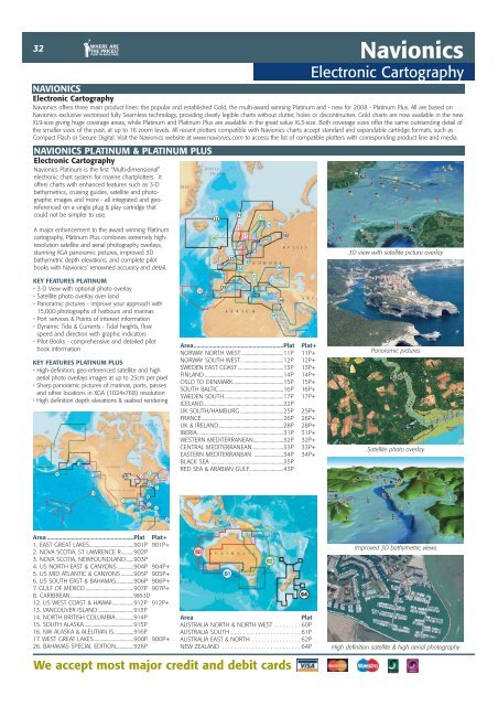
3D view with satellite picture overlay<br />
KEY FEATURES PLATINUM<br />
• 3-D View with optional photo overlay<br />
• Satellite photo overlay over land<br />
• Panoramic pictures - improve your approach with<br />
15,000 photographs of harbours and marinas<br />
• Port services & Points of interest information<br />
• Dynamic Tide & Currents - Tidal heights, flow<br />
speed and direction with graphic indicators<br />
• Pilot Books - comprehensive and detailed pilot<br />
book information<br />
Area...........................................................Plat<br />
NORWAY NORTH WEST .................................11P<br />
Plat+<br />
11P+<br />
Panoramic pictures<br />
KEY FEATURES PLATINUM PLUS<br />
• High-definition, geo-referenced satellite and high<br />
aerial photo overlays images at up to 25cm per pixel<br />
• Sharp panoramic pictures of marinas, ports, passes<br />
and o<strong>the</strong>r locations in XGA (1024x768) resolution<br />
• High definition depth elevations & seabed rendering<br />
NORWAY SOUTH WEST..................................12P<br />
SWEDEN EAST COAST ....................................13P<br />
FINLAND ..............................................................14P<br />
OSLO TO DENMARK........................................15P<br />
SOUTH BALTIC ...................................................16P<br />
SWEDEN SOUTH...............................................17P<br />
ICELAND...............................................................22P<br />
12P+<br />
13P+<br />
14P+<br />
15P+<br />
16P+<br />
17P+<br />
UK SOUTH/HAMBURG ..................................25P 25P+<br />
FRANCE.................................................................26P 26P+<br />
UK & IRELAND...................................................28P 28P+<br />
IBERIA....................................................................31P 31P+<br />
WESTERN MEDITERRANEAN........................32P 32P+<br />
CENTRAL MEDITERRANEAN.........................33P<br />
EASTERN MEDITERRANEAN .......................34P<br />
BLACK SEA .........................................................35P<br />
RED SEA & ARABIAN GULF...........................43P<br />
33P+<br />
34P+<br />
Satellite photo overlay<br />
Area .........................................................Plat Plat+<br />
1. EAST GREAT LAKES...................................901P 901P+<br />
2. NOVA SCOTIA, ST LAWRENCE R..........902P<br />
3. NOVA SCOTIA, <strong>NEW</strong>FOUNDLAND......903P<br />
4. US NORTH EAST & CANYONS .............904P 904P+<br />
5. US MID ATLANTIC & CANYONS ..........905P 905P+<br />
6. US SOUTH EAST & BAHAMAS..............906P 906P+<br />
7. GULF OF MEXICO ......................................907P 907P+<br />
8. CARIBBEAN..................................................908-3D<br />
12. US WEST COAST & HAWAII.................912P 912P+<br />
13. VANCOUVER ISLAND ............................913P<br />
14. NORTH BRITISH COLUMBIA ..............914P<br />
15. SOUTH ALASKA .......................................915P<br />
16. NW ALASKA & ALEUTIAN IS. ..............916P<br />
17. WEST GREAT LAKES ...............................900P 900P+<br />
26. BAHAMAS SPECIAL EDITION..............926P<br />
Area Plat<br />
AUSTRALIA NORTH & NORTH WEST . . . . . . . . . 60P<br />
AUSTRALIA SOUTH . . . . . . . . . . . . . . . . . . . . . . . 61P<br />
AUSTRALIA EAST & NORTH . . . . . . . . . . . . . . . . 62P<br />
<strong>NEW</strong> ZEALAND . . . . . . . . . . . . . . . . . . . . . . . . . . 64P<br />
Improved 3D bathymetric views<br />
High definition satellite & high aerial photography