Fennoscandian Lesser White-fronted Goose conservation project ...
Fennoscandian Lesser White-fronted Goose conservation project ...
Fennoscandian Lesser White-fronted Goose conservation project ...

Create successful ePaper yourself
Turn your PDF publications into a flip-book with our unique Google optimized e-Paper software.
<strong>Fennoscandian</strong> <strong>Lesser</strong> <strong>White</strong>-<strong>fronted</strong> <strong>Goose</strong> <strong>conservation</strong> <strong>project</strong> – Annual report 1999<br />
Morozov: Surveys for <strong>Lesser</strong> <strong>White</strong>-<strong>fronted</strong> <strong>Goose</strong> in the Bolshezemelskaya Tundra, European Russia, in 1999<br />
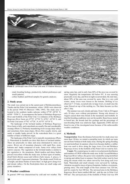
Photo 2. Landscape view of the Polar Ural area. © Vladimir Morozov, 1999<br />
36<br />
– study breeding biology, productivity, habitat preferences and<br />
moult patterns;<br />
– collect feathers and blood samples for genetic analyses.<br />
2. Study areas<br />
The study was carried out in the eastern part of Bolshezemelskaya<br />
Tundra and the Polar Ural mountains, where LWfG were observed<br />
in the period 1984–93 (Morozov 1988, 1995). The study area is<br />
located in the southern tundra subzone within 67º30’–68º30’ N,<br />
60º00’–70º00’ E. It encompasses the basins of Bolshaya Rogovaya<br />
River and foothills of the Polar Ural. Co-ordinates of the Bolshaya<br />
Rogovaya River basin are 67º25’–67º36’ N, 62º01’–62º30’ E, and<br />
for Polar Ural areas: 67º02’–67º28’, N, 63º55’–65º10’ E.<br />
The landscape of the lowland tundras of Bolshaya Rogovaya<br />
River basin is hilly, and watersheds are usually flat and considerably<br />
swampy (Photo 1). Profusely meandering rivers occupy deep valleys<br />
and sometimes form steep slopes. Rivers flow usually slowly, and<br />
sandy or muddy banks prevail. In the watersheds there is a great<br />
number of lakes of different origin.<br />
The landscape of the Polar Ural is typically mountainous (Photo<br />
2). Watersheds in foothills are drier than those of lowland tundras.<br />
There are practically no lakes and areas dominated by mires are<br />
scarce. Rivers are of mountain character with rapid flow, stony<br />
bottoms and banks composed of rocks. Some river valleys form<br />
narrow canyons. The vegetation in the lowland tundra is similar to<br />
the vegetation in the mountains. Shrub tundras and dense bushes<br />
prevail everywhere within the study area. In these types of tundras,<br />
dwarf birch (Betula nana) and willows (Salix lanata, S. glauca, S.<br />
phylicifolia and S. lapponum) dominate. The shrubs reach 50-60 cm<br />
in height, and dense bushes of more than 2 m high grow along river<br />
and stream valleys. On the flood-plains there are small sedge and<br />
grassy meadows.<br />
3. Weather conditions<br />
In general 1999 was characterised by cold and wet weather. The<br />
spring came late, and in early June 80% of the area was covered by<br />
snow. Regularly the temperature fell below 0ºC. It was snowing<br />
practically every day, and frost at night occurred daily. By mid June,<br />
about 50% of the area was covered by snow. Due to a very cold<br />
winter, many rivers were frozen to the bottom. Drifting of ice<br />
observed 7–15 June, occurred only in large rivers, in small ones the<br />
water flowed on top of the melting ice. The lakes became ice-free<br />
after 5 July.<br />
The summer was cool, cloudy and rainy. From 1 July to 20 August<br />
only 20 days were without precipitation. Strong rain showers in<br />
August caused short time floods in the mountains and foothills. In<br />
total the breeding conditions were not favourable. Bean Geese started<br />
to breed late, the broods had few goslings and the percentage of<br />
non-breeding birds was relatively high. Apparently LWfG did not<br />
breed in one of the investigated areas because of the unfavourable<br />
weather conditions.<br />
4. Methods<br />
Transportation. Since the distance between the two study areas was<br />
more than 150 km, we rented a caterpillar truck, by which our team<br />
moved from Vorkuta to both study areas. During the spring flooding<br />
we used motorboat. In summer, when rivers became shallow, a rubber<br />
boat was used to drive along the large rivers (Usa and Bolshaya<br />
Rogovaya rivers). In the foothills of the Polar Ural we went by foot.<br />
Counts. We counted geese in order to reveal present distribution<br />
and numbers of LWfG within the study area. In the Usa and Bolshaya<br />
Rogovaya River valleys, the geese were counted by using motorboat<br />
in spring and rubber boat in summer. One field worker went by boat<br />
along the stream while two others moved by foot along each river<br />
bank. Watersheds and small streams were surveyed by walking.<br />
Attention was paid to traces of geese (footprints, feathers, excrements,<br />
grazing sites). The total length of the boat censuses was 320 km,<br />
and for counts by foot 440 km. The surveyed area in the Bolshaya<br />
Rogovaya River basin totalled 400 km2 , and the one in Polar Ural<br />
950 km2 . The surveyed area of the foothills of Polar Ural was 450