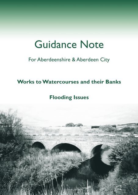
Works to Watercourses and their Banks: Flooding (pdf
Works to Watercourses and their Banks: Flooding (pdf
Works to Watercourses and their Banks: Flooding (pdf

You also want an ePaper? Increase the reach of your titles
YUMPU automatically turns print PDFs into web optimized ePapers that Google loves.
Guidance Note<br />
For Aberdeenshire & Aberdeen City<br />
<strong>Works</strong> <strong>to</strong> <strong>Watercourses</strong> <strong>and</strong> <strong>their</strong> <strong>Banks</strong><br />
<strong>Flooding</strong> Issues
2<br />
1. Introduction<br />
Our rivers <strong>and</strong> burns contribute much<br />
<strong>to</strong> the character <strong>and</strong> industry of both<br />
Aberdeenshire <strong>and</strong> Aberdeen City.<br />
They provide us with water <strong>to</strong> drink,<br />
an essential resource in terms of<br />
agriculture, industry, commerce<br />
(angling <strong>and</strong> the <strong>to</strong>urist trade), natural<br />
habitats, biodiversity <strong>and</strong> an everpresent<br />
refuge from the stresses <strong>and</strong><br />
strains of contemporary life. This<br />
being the case, it is of the first<br />
importance that we manage our<br />
watercourses <strong>and</strong> <strong>their</strong> floodplains in<br />
such a manner as <strong>to</strong> conserve those<br />
qualities for which we should so value<br />
them, as well as utilising <strong>their</strong><br />
potential in a sustainable manner. This<br />
means that we must properly consider<br />
the wider implications of any<br />
management works we may<br />
undertake.<br />
Even when management works or<br />
development in or near <strong>to</strong> a river or<br />
burn has been carefully thought out<br />
<strong>and</strong> executed there may be a knock-on<br />
effect on stretches out-with the<br />
immediate area of the work <strong>and</strong><br />
sometimes at a considerable distance.<br />
Erosion may be accelerated in some<br />
localities, <strong>and</strong> displaced material may<br />
affect water quality, damage spawning<br />
grounds, infill pools, <strong>and</strong> result in<br />
siltation. Such effects can threaten <strong>and</strong><br />
disturb wildlife, alter the natural<br />
function of the river system, damage<br />
water abstraction plants, incur<br />
financial costs for others <strong>and</strong> detract<br />
from the scenic appeal of the area.<br />
Aberdeen <strong>and</strong> Aberdeenshire has a<br />
range of river catchments varying in<br />
attributes <strong>and</strong> associated management<br />
issues. Sections of the River Dee lie<br />
within Sites of Special Scientific<br />
Interest <strong>and</strong> the River Dee has been<br />
proposed as a Special Area of<br />
Conservation. The lower stretch of the<br />
River Ythan is also of great importance<br />
for nature conservation <strong>and</strong> falls<br />
within a National Nature Reserve. The<br />
Ythan Catchment is designated as a<br />
Nitrate Vulnerable Zone under the EU<br />
Nitrates Directive <strong>and</strong> much of the<br />
remainder of Aberdeenshire has been<br />
proposed for designation (as at<br />
February 2002). A project centred on<br />
the River Ugie promoted good<br />
riparian management. Significant<br />
stretches of our rivers <strong>and</strong> <strong>their</strong><br />
tributaries have important spawning<br />
beds for salmonids. There are a wide<br />
range of river-related projects <strong>and</strong><br />
initiatives currently underway aiming<br />
<strong>to</strong> benefit salmonids <strong>and</strong> other species<br />
<strong>and</strong> riparian habitats.<br />
This is a practical guide for anyone<br />
with an interest in carrying out<br />
projects associated with watercourses,<br />
<strong>their</strong> banks <strong>and</strong> floodplains <strong>and</strong><br />
drainage of l<strong>and</strong> for any purpose. This<br />
includes l<strong>and</strong>owners, farmers,<br />
contrac<strong>to</strong>rs, developers, statu<strong>to</strong>ry<br />
undertakers <strong>and</strong> fisheries interests.<br />
The guidance is divided in<strong>to</strong> two<br />
sections, the first section deals with<br />
works <strong>to</strong> watercourses <strong>and</strong> <strong>their</strong> banks,<br />
the second deals with flooding issues.<br />
Against the background of the<br />
legislation (Appendix A) the guidance<br />
explains the necessary steps <strong>to</strong> follow <strong>to</strong><br />
secure the appropriate permissions for<br />
different projects. Key contacts <strong>and</strong><br />
additional sources of useful information<br />
are detailed in Appendix B <strong>and</strong> C<br />
respectively.
<strong>Works</strong> <strong>to</strong> <strong>Watercourses</strong> <strong>and</strong> <strong>their</strong> <strong>Banks</strong>:<br />
2. Guidelines for l<strong>and</strong>owners, farmers, fisheries<br />
interests, developers, contrac<strong>to</strong>rs, statu<strong>to</strong>ry<br />
undertakers, local authorities, <strong>and</strong> Scottish Water<br />
2.1 Consultation 2.2 Timing<br />
When planning any works in or on<br />
l<strong>and</strong> adjacent <strong>to</strong> watercourses, you<br />
should consider what permission,<br />
consents, notifications or consultations<br />
are necessary. Informal consultation<br />
should be held early, at least 3 months<br />
in advance of the intended start date.<br />
In the case of formal consents this<br />
should also be considered at least 3<br />
months in advance of the intended<br />
date of commencement of site<br />
operations. No work should<br />
commence until informal<br />
consultations are carried out <strong>and</strong><br />
formal consent is obtained, where it is<br />
required. As the legislative framework<br />
changes activities that may not have<br />
required formal consent in the past<br />
may do so. It is therefore necessary <strong>to</strong><br />
consult the relevant agencies in all<br />
cases.<br />
2.3 Legislation<br />
The following Acts <strong>and</strong> Regulations may be relevant, <strong>and</strong> the Local Planning<br />
Authority <strong>and</strong> other relevant agencies should be consulted on an informal basis <strong>to</strong><br />
establish whether or not they may constrain, or indeed, prohibit the works proposed:<br />
■The Town <strong>and</strong> Country Planning (Scotl<strong>and</strong>) Act 1997<br />
Work within a salmon river<br />
should generally be carried<br />
out during June, July <strong>and</strong><br />
August <strong>to</strong> restrict<br />
disturbance <strong>to</strong> salmon<br />
spawning,the e mergnce of<br />
the fry <strong>and</strong> emigration of<br />
the smolts. No work should<br />
commence until formal<br />
consent is obtained, where<br />
it is required. The season for<br />
operations in rivers is<br />
critical <strong>and</strong> timing should<br />
be established with the<br />
relevant District Salmon<br />
Fisheries Boards (DSFB).<br />
Constraint on timing in<br />
relation <strong>to</strong> other freshwater<br />
interests should also be<br />
considered in the light of<br />
advice from SNH.<br />
■ The Town <strong>and</strong> Country Planning (General Permitted Development) (Scotl<strong>and</strong>) Order 1992<br />
■ The Environmental Impact Assessment Regulations Scotl<strong>and</strong> 1999<br />
■ Wildlife <strong>and</strong> Countryside Act 1981<br />
■ The Conservation (Natural Habitats etc.) Regulations 1994<br />
■ The Salmon Fisheries (Scotl<strong>and</strong>) Act 1868<br />
The requirements of the above <strong>and</strong> additional Acts <strong>and</strong> Regulations are given in<br />
Appendix A.<br />
Frog<br />
3
4<br />
3. Key consultees<br />
3.1 Planning Authority -<br />
Development Control<br />
Planning Permission will not be<br />
required in every case but this does<br />
not remove the essential need <strong>to</strong><br />
consult the relevant agencies (listed<br />
at Appendix B) <strong>to</strong> avoid damaging<br />
works. As the interests vary from river<br />
<strong>to</strong> river the Planning Authority will<br />
exercise its judgement on a case by<br />
case basis in accordance with adopted<br />
planning policy <strong>and</strong> best practice.<br />
Generally, work involving mechanical<br />
plant, particularly for excavation <strong>and</strong>/<br />
or construction will fall within the<br />
definition of "engineering operations"<br />
<strong>and</strong> planning permission will be<br />
required unless it is permitted<br />
development as defined in the Town<br />
<strong>and</strong> Country Planning General<br />
Permitted Development (Scotl<strong>and</strong>)<br />
Order 1992 (see Appendix A). The<br />
Area Planning Officer (listed at Appendix<br />
B) can advise on this.<br />
3.2 Local Authority - Nature<br />
Conservation<br />
Even small projects can have a<br />
considerable effect on the functioning<br />
of a river system. In addition <strong>to</strong><br />
considering the legislative controls<br />
<strong>and</strong> permissions for projects you are<br />
encouraged <strong>to</strong> explore alternatives <strong>to</strong><br />
hard engineering <strong>and</strong> look for<br />
sustainable solutions which follow<br />
best practice <strong>and</strong> are consistent with<br />
the local river environment. This<br />
includes consideration of<br />
opportunities <strong>to</strong> enhance <strong>and</strong> res<strong>to</strong>re<br />
the river <strong>and</strong> associated habitat. A<br />
number of guidance notes on specific<br />
<strong>to</strong>pics <strong>and</strong> works are commended <strong>to</strong><br />
help you plan projects <strong>and</strong> consider<br />
the best options for the river<br />
environment (Appendix C).<br />
Heron<br />
Aberdeenshire Council's Natural<br />
Heritage Team can provide advice on<br />
sources of relevant guidance<br />
(Appendix B).<br />
Key Guidance Notes <strong>and</strong> Leaflets<br />
Dredging, Ditching <strong>and</strong> Drainage -<br />
Minimising the Risks <strong>to</strong> Wildlife<br />
Pond Design - Considerations for<br />
Wildlife <strong>and</strong> L<strong>and</strong>scape<br />
Riparian Management - Looking after<br />
Aberdeenshire's Burns <strong>and</strong> River<br />
<strong>Banks</strong><br />
Drainage Impact Assessment - A<br />
Guidance Note for Developers <strong>and</strong><br />
Regula<strong>to</strong>rs<br />
Culverting - An Agenda for Action<br />
Details of these leaflets <strong>and</strong> others are<br />
listed in Appendix C.<br />
3.3 Local Authority - Flood<br />
Management<br />
<strong>Works</strong> within or on the banks of<br />
watercourses can often have a<br />
detrimental effect elsewhere. All<br />
works which change the physical<br />
characteristics within or on the banks<br />
of the watercourse should be<br />
discussed with the relevant authorities<br />
beforeh<strong>and</strong> <strong>to</strong> assess the likely impact<br />
of the proposals.<br />
Any works which change the direction<br />
or speed of water flow have the<br />
potential <strong>to</strong> cause scour which may<br />
then affect the stability of river banks,<br />
river bed, training walls, bridge piers<br />
<strong>and</strong> the like. Any works which<br />
canalise the river have the potential <strong>to</strong><br />
cause flooding downstream by<br />
reducing flood plain s<strong>to</strong>rage under<br />
spate conditions. The likelihood of<br />
scour damage or flooding arising as a
consequence of proposed works<br />
should be assessed during the<br />
planning process.<br />
Engineering staff in the Structures<br />
Section of Transportation &<br />
Infrastructure will be happy <strong>to</strong> advise<br />
(see Appendix B).<br />
3.4 District Salmon Fisheries<br />
Boards<br />
The relevant District Salmon Fishery<br />
Board should be contacted for advice<br />
on any works <strong>to</strong> a river or its banks,<br />
including water abstraction, see<br />
Appendix B for contacts for the<br />
relevant Fishery Boards. District<br />
Salmon Fishery Boards will provide<br />
advice on timing <strong>and</strong> method of<br />
works appropriate <strong>to</strong> a site. District<br />
Salmon Fishery Boards have powers<br />
<strong>to</strong> take action under the Salmon<br />
Fisheries (Scotl<strong>and</strong>) Act (Appendix A)<br />
against anyone found <strong>to</strong> have caused<br />
the wilful destruction or disturbance<br />
of salmon spawn or spawning beds.<br />
The Salmon (Fish Pass <strong>and</strong> Screens)<br />
(Scotl<strong>and</strong>) Regulations 1994<br />
(Appendix A) require the owner or<br />
occupier of a dam <strong>to</strong> ensure free<br />
passage of migra<strong>to</strong>ry fish both up <strong>and</strong><br />
down stream <strong>and</strong> the owner or<br />
occupier of any water abstraction<br />
point <strong>to</strong> provide screens <strong>to</strong> prevent<br />
passage of salmon smolts at the intake<br />
<strong>and</strong> adults access <strong>to</strong> the outlet.<br />
3.5 Adjacent L<strong>and</strong>owners<br />
These guidelines have been prepared<br />
in consultation with l<strong>and</strong>-owning<br />
interests. It is recommended that<br />
informal consultation<br />
should include<br />
notifying<br />
l<strong>and</strong>owners up,<br />
down <strong>and</strong> across<br />
the watercourse<br />
well in advance of<br />
intended works.<br />
Trout<br />
3.6 Scottish Environment<br />
Protection Agency (SEPA)<br />
Any work carried out in or near<br />
watercourses must be regarded as<br />
high risk with significant potential <strong>to</strong><br />
cause pollution. Silt, cement, concrete,<br />
fuel, lubrication <strong>and</strong> shutter release<br />
oils, petrol, sewage, bridge cleaning<br />
debris <strong>and</strong> other waste materials have<br />
the potential <strong>to</strong> cause significant<br />
damage. The Control of Pollution Act<br />
1974 (Appendix A), gives SEPA power<br />
<strong>to</strong> protect rivers, streams,<br />
groundwater <strong>and</strong> inshore coastal<br />
waters from pollution. SEPA should be<br />
consulted on any work which has<br />
potential <strong>to</strong> cause pollution. Guidance<br />
on such work is given in SEPA's<br />
Pollution Prevention Guidelines 5:<br />
"<strong>Works</strong> in, near or liable <strong>to</strong> affect<br />
watercourses." Pollution Prevention<br />
Guidelines 6: "Working at construction<br />
<strong>and</strong> demolition sites" may also be<br />
relevant. It is important <strong>to</strong> highlight<br />
that sediment released, for example,<br />
by dredging is a potentially serious<br />
pollutant.<br />
SEPA will be the Lead Agency with<br />
statu<strong>to</strong>ry responsibility for<br />
implementation of the Water<br />
Environment Act in Scotl<strong>and</strong> (See<br />
Water Framework Directive Appendix<br />
A). This Act is likely <strong>to</strong> have wide<br />
reaching implications for what is<br />
acceptable in terms of work <strong>to</strong><br />
watercourses, including water<br />
abstraction, impoundment, l<strong>and</strong><br />
drainage <strong>and</strong> other engineering<br />
works. These guidelines will be<br />
reviewed <strong>to</strong> include additional<br />
controls necessary once the Water<br />
Environment Act comes in<strong>to</strong> force.<br />
Further information on the Water<br />
Framework Directive <strong>and</strong> the Water<br />
Environment Act is available from<br />
SEPA (Appendix B).<br />
5
6<br />
3.7 Scottish Natural Heritage<br />
(SNH)<br />
Written consent must be obtained<br />
from SNH by the owner or occupier <strong>to</strong><br />
undertake drainage or other works<br />
listed as Potentially Damaging<br />
Operations which affect Sites of<br />
Special Scientific Interest (SSSIs). SNH<br />
can advise on proposals which affect<br />
National Nature Reserves <strong>and</strong> Ramsar<br />
sites which may or may not be SSSIs,<br />
<strong>and</strong> on species protected under the<br />
Wildlife <strong>and</strong> Countryside Act 1981<br />
(Appendix A). SNH should be<br />
consulted on all works which may<br />
significantly affect a designated or<br />
proposed European Site (SAC or SPA).<br />
Permitted Development Rights may<br />
be withdrawn if projects have the<br />
potential <strong>to</strong> significantly affect the<br />
interests for which the European Site<br />
has been designated, <strong>and</strong> advice<br />
should be sought from the Planning<br />
Authority. The River Dee has been<br />
identified as a possible SAC in<br />
recognition of the importance of its<br />
populations of freshwater pearl<br />
mussel, Atlantic salmon <strong>and</strong> otter. If<br />
the Dee becomes a c<strong>and</strong>idate SAC or<br />
is designated as a SAC it will have a<br />
considerable impact on the consent<br />
procedure for work associated with<br />
the river. Regardless of SAC<br />
designation many species are legally<br />
protected (e.g. freshwater pearl<br />
mussel, otter, water vole <strong>and</strong> all<br />
species of bat) <strong>and</strong> expert advice<br />
should be sought from SNH on any<br />
work which may affect these species.<br />
Otter<br />
3.8 His<strong>to</strong>ric Scotl<strong>and</strong> - Cultural<br />
Heritage<br />
Written consent must be obtained<br />
from His<strong>to</strong>ric Scotl<strong>and</strong> where arterial<br />
drainage or river works may affect the<br />
integrity of a Scheduled Ancient<br />
Monument.<br />
3.9 Further Sources of Advice<br />
In addition <strong>to</strong> the list of consultees<br />
above, other organisations that can<br />
provide advice <strong>and</strong> guidance are listed<br />
in Appendix B.<br />
Consultation Requirements<br />
Initial advice may be obtained by<br />
phone or email. A plan, description of<br />
the proposal, method statement <strong>and</strong><br />
timing schedule may be requested<br />
before advice can be given. In the<br />
event of a major engineering operation<br />
being intended it will be necessary <strong>to</strong><br />
obtain a report from a qualified<br />
hydrologist <strong>and</strong>/or fluviogeomorphologist.
<strong>Flooding</strong> Issues:<br />
4. Guidelines for l<strong>and</strong>owners, farmers, fisheries<br />
interests, developers, contrac<strong>to</strong>rs, statu<strong>to</strong>ry<br />
undertakers, local authorities, <strong>and</strong> Scottish Water<br />
4.1 Policy Guidance<br />
Planning policy is guiding<br />
developers away from areas which<br />
are at risk of flooding, such as flood<br />
plains. This is in recognition of the<br />
importance of floodplains <strong>and</strong><br />
flooding as part of naturally<br />
functioning river systems.<br />
4.2<br />
4.3<br />
National Planning Policy Guidelines<br />
(NPPG 7) on Planning <strong>and</strong> <strong>Flooding</strong><br />
state that 'in accordance with the<br />
precautionary principle, planning<br />
authorities should first, seek <strong>to</strong> avoid<br />
increasing the flood risk by refusing<br />
permission where appropriate, <strong>and</strong><br />
secondly, seek <strong>to</strong> manage the threat of<br />
flooding only in cases where other<br />
reasons for granting permission take<br />
precedence over flood risk'. This<br />
guidance should ensure that decisions<br />
in relation <strong>to</strong> areas of existing <strong>and</strong><br />
future development take account of<br />
flood risk, whether inl<strong>and</strong> or on the<br />
coast.<br />
This is further supported by policy in<br />
the Aberdeen <strong>and</strong> Aberdeenshire<br />
Structure Plan (North East Scotl<strong>and</strong><br />
Together 2001-2016). Policy 22: Water<br />
Management, states that<br />
'Development shall be directed away<br />
from areas at significant risk from<br />
flooding according <strong>to</strong> the sensitivity of<br />
the development <strong>and</strong> the risk of<br />
flooding of the site. Functional<br />
floodplains should be allowed <strong>to</strong><br />
flood naturally where appropriate'.<br />
4.4<br />
4.5<br />
will be required <strong>to</strong> provide Flood Risk<br />
Assessments for proposals in<br />
appropriate cases'.<br />
Policy 19: Wildlife, L<strong>and</strong>scape <strong>and</strong><br />
L<strong>and</strong> Resources states that<br />
'development will be sited <strong>and</strong><br />
designed <strong>to</strong> avoid adverse impacts on<br />
the biodiversity of a site, including its<br />
environmental quality, ecological<br />
status <strong>and</strong> viability'. The impact of any<br />
work on biodiversity <strong>and</strong> habitat will<br />
therefore have <strong>to</strong> be considered.<br />
The relevant Local Plan will provide<br />
specific policy on flooding <strong>and</strong> should<br />
be consulted as required.<br />
In summary l<strong>and</strong> use should take<br />
account of areas where the risk of<br />
flooding is considered <strong>to</strong> be<br />
significant, either on-site, upstream<br />
or downstream. Development is<br />
discouraged where it would:<br />
■ be at risk or would intensify the<br />
risk of flooding <strong>to</strong> existing or<br />
proposed development;<br />
■ be likely <strong>to</strong> require high levels of<br />
public expenditure on flood<br />
protection works, or;<br />
■ result in extensive channel<br />
modification <strong>and</strong>/or loss of habitat/<br />
biodiversity.<br />
This policy also states that 'developers Water crowfoot Common reed<br />
7
8<br />
5. The Causes of <strong>Flooding</strong><br />
5.1<br />
5.2<br />
At its simplest, steep watercourses<br />
draining small rocky catchments will<br />
quickly respond <strong>to</strong> rainfall <strong>and</strong>, along<br />
with urbanised catchments, are most<br />
affected by intense rainfall of short<br />
duration. Larger rivers respond more<br />
slowly, with flooding most likely <strong>to</strong><br />
result from steady rainfall over a<br />
longer period of perhaps 1-2 days.<br />
<strong>Flooding</strong> can result from several<br />
causes, for example: -<br />
■ a large catchment relative <strong>to</strong> the size<br />
of the watercourse draining it;<br />
■ rapid snow-melt in upl<strong>and</strong> areas<br />
feeding already high river flows;<br />
■ high spring tides <strong>and</strong> strong winds<br />
creating s<strong>to</strong>rm surges in coastal areas;<br />
■ lack of maintenance of defence<br />
systems, watercourses, culverts<br />
(including the flood relief areas about<br />
them) <strong>and</strong> road gullies;<br />
■ canalisation, modification <strong>and</strong><br />
diversion of rivers <strong>and</strong> watercourses<br />
which increases the rate of flow <strong>and</strong><br />
decreases the time taken for water <strong>to</strong><br />
travel within the catchment;<br />
■ progressive development, increasing<br />
the cover of impermeable surfaces in<br />
catchments results in increased rate<br />
<strong>and</strong> volume of run-off<br />
■ sub-st<strong>and</strong>ard agricultural practices<br />
e.g. badly designed <strong>and</strong> constructed<br />
modifications <strong>to</strong> river channels <strong>and</strong><br />
inappropriate drainage works;<br />
■ l<strong>and</strong> drainage activities for any<br />
purpose - often resulting in the loss of<br />
wetl<strong>and</strong>s <strong>and</strong> flood s<strong>to</strong>rage areas but<br />
also causing soil moisture deficit<br />
which can then require remedial<br />
irrigation;<br />
■ poor forestry practices e.g. badly<br />
designed ploughing <strong>and</strong> drainage in<br />
upl<strong>and</strong> areas <strong>and</strong> increased<br />
deforestation;<br />
■ direct loss of floodplain <strong>to</strong><br />
development <strong>and</strong> associated building<br />
of structures (e.g. embankments)<br />
which restrict s<strong>to</strong>rage within his<strong>to</strong>rical<br />
flood plains <strong>and</strong> create additional<br />
flood risks downstream;<br />
■ silt or gravel movement which raises<br />
the river bed level thereby reducing<br />
channel capacity;<br />
■ local blockages (e.g. blocked culverts);<br />
■ undersized structures such as small<br />
culverts <strong>and</strong> bridges with low<br />
headroom, which restrict channel<br />
capacity;<br />
■ inadequate or inappropriate<br />
culverting which increases the flow<br />
rate but can also restrict flow volume<br />
at high flows, creating flooding upstream<br />
of the culvert;<br />
■ development including road<br />
construction which results in paved<br />
areas of significant size, can lead <strong>to</strong><br />
changes in the run-off characteristics<br />
of a watercourse's catchment area <strong>and</strong><br />
hence the local drainage regime.
6. Responsibilities for<br />
Flood Protection <strong>and</strong><br />
Prevention<br />
6.1 Owners Responsibilities<br />
The prime responsibility for<br />
safeguarding l<strong>and</strong> or property against<br />
natural hazards such as flooding<br />
remains with the owner, including<br />
local authorities as owners of l<strong>and</strong> <strong>and</strong><br />
property.<br />
6.2 Local Authority<br />
Responsibilities<br />
Local authorities have the leading role<br />
under the Flood Prevention <strong>and</strong> L<strong>and</strong><br />
Drainage (Scotl<strong>and</strong>) Act 1997. The Act<br />
requires Local Authorities <strong>to</strong> assess the<br />
likelihood of flooding of any nonagricultural<br />
l<strong>and</strong> in <strong>their</strong> areas <strong>and</strong><br />
gives discretionary powers <strong>to</strong> Local<br />
Authorities <strong>to</strong> carry out works of<br />
maintenance <strong>to</strong> reduce the likelihood<br />
of flooding.<br />
6.3 Planning Authority<br />
Responsibilities<br />
As the Planning Authority the Local<br />
Authority is responsible for regulation<br />
of development under the Town <strong>and</strong><br />
Country Planning Act (Appendix A).<br />
Development includes any<br />
engineering works <strong>to</strong> rivers, flood<br />
plains, culverts etc. all of which may<br />
affect the local flooding regime.<br />
Regulation of these works is guided<br />
by national advice <strong>and</strong> legislation <strong>and</strong><br />
Council Development Plan Policy<br />
(Appendix A).<br />
Key points <strong>to</strong> be considered include: -<br />
■ Requirements for new or improved<br />
flood defences should be provided at<br />
the developer's expense where they<br />
are directly attributable <strong>to</strong> the<br />
development proposals.<br />
■ Flood related conditions of planning<br />
permission will be rigorously<br />
enforced.<br />
■ All proposals should include an<br />
allowance for climate change, with the<br />
expected life of the development<br />
being a key issue.<br />
6.4 The Role of Building<br />
St<strong>and</strong>ards<br />
Part G, regulation 16 of the Technical<br />
St<strong>and</strong>ards for compliance with the<br />
Building St<strong>and</strong>ards (Scotl<strong>and</strong>)<br />
Regulations 1990 as amended,<br />
requires protection of buildings <strong>and</strong><br />
<strong>their</strong> users from the effects of<br />
moisture. This includes the<br />
preparation of the ground adjoining a<br />
building <strong>to</strong> minimise the risk of<br />
flooding. The regulation states that “a<br />
site, <strong>and</strong> ground immediately<br />
adjoining a site, shall be so drained or<br />
otherwise treated as <strong>to</strong> protect the<br />
building <strong>and</strong> its users, so far as may<br />
be reasonably practicable, from<br />
harmful effects caused by (a)<br />
groundwater, (b) flood water, <strong>and</strong> (c)<br />
existing drains.” This applies <strong>to</strong> all<br />
new building work except certain<br />
limited life buildings. These<br />
regulations are intended <strong>to</strong> ensure that<br />
suitable <strong>and</strong> adequate drainage is<br />
designed <strong>and</strong> installed <strong>to</strong><br />
accommodate normal conditions.<br />
Dipper<br />
9
10<br />
Water vole<br />
6.5 Local Authority - Flood<br />
Appraisal Groups<br />
Local authorities take a lead role in coordinating<br />
measures <strong>and</strong> responses <strong>to</strong><br />
flooding. A Flood Appraisal Group<br />
has been jointly formed between<br />
Aberdeenshire <strong>and</strong> Aberdeen City<br />
Councils, <strong>and</strong> appropriate agencies <strong>to</strong><br />
provide the Local Authorities with<br />
practical guidance <strong>and</strong> information on<br />
flood risk <strong>and</strong> its implications for<br />
development. Issues which will form<br />
the basis for discussion in Flood<br />
Appraisal Groups include information<br />
<strong>and</strong> data requirements, catchment<br />
management, flood management<br />
schemes, other mitigation measures,<br />
watercourse repair <strong>and</strong> maintenance,<br />
development plan l<strong>and</strong> allocations,<br />
significant development proposals<br />
<strong>and</strong> future research requirements. The<br />
Flood Appraisal Group (see contact in<br />
Appendix B) intends <strong>to</strong> draw in a<br />
wide range of expertise <strong>and</strong> local<br />
interests <strong>to</strong> provide information <strong>and</strong><br />
opinion on specific issues <strong>and</strong><br />
contribute <strong>to</strong> the work of the group.<br />
6.6 SEPA (Scottish Environment<br />
Protection Agency) - Flood<br />
Risk Assessment <strong>and</strong> Flood<br />
Warning<br />
SEPA has a statu<strong>to</strong>ry role under the<br />
Environment Act (1995) <strong>to</strong> provide<br />
Local Authorities with advice on the<br />
risk of flooding on request. This duty<br />
includes advising against the granting<br />
of planning permission for any area<br />
SEPA has assessed as being at risk of<br />
flooding. SEPA also has discretionary<br />
powers <strong>to</strong> establish <strong>and</strong> operate Flood<br />
Warning Schemes.<br />
SEPA will be the Lead Agency with<br />
statu<strong>to</strong>ry responsibility for the<br />
implementation of the Water<br />
Framework Directive in Scotl<strong>and</strong>. The<br />
Directive requires the development of<br />
River Basin Management Plans which<br />
will be underpinned by planning at<br />
the catchment level. Policy developed<br />
through the River Basin <strong>and</strong><br />
Catchment Management Planning<br />
process will inform Council<br />
Development Plan Policy.<br />
6.7 SEERAD (Scottish Executive<br />
Environment <strong>and</strong> Rural Affairs<br />
Department) - Agricultural<br />
L<strong>and</strong> Under Grant Schemes<br />
SEERAD exercises control over all<br />
work done under agricultural grant<br />
aided schemes. With the exception of<br />
emergency floodbank repairs, farmers<br />
must obtain SEERAD's prior approval<br />
before starting any kind of arterial<br />
drainage or river works on which they<br />
intend <strong>to</strong> claim grant. SEERAD has<br />
produced a guidance booklet on the<br />
Rural Stewardship Scheme with<br />
information on habitat enhancement<br />
possible under the scheme (Appendix C).<br />
6.8 SNH (Scottish Natural<br />
Heritage) - Areas of National<br />
<strong>and</strong> International Importance<br />
<strong>to</strong> Nature Conservation<br />
Written consent must be obtained<br />
from SNH by the owner or occupier <strong>to</strong><br />
undertake drainage or other works<br />
listed as Potentially Damaging<br />
Operations which affect Sites of<br />
Special Scientific Interest. SNH should<br />
be consulted on all drainage or flood<br />
prevention projects which may<br />
significantly affect a designated or<br />
proposed European Site (SAC or SPA).
6.9 Forestry Commission -<br />
Forestry <strong>and</strong> Woodl<strong>and</strong><br />
Planting <strong>and</strong> Felling<br />
The Forestry Commission exercises<br />
control over all afforestation schemes<br />
which are grant aided under the<br />
Woodl<strong>and</strong> Grant Scheme <strong>and</strong> all<br />
felling where a licence is required.<br />
Approval is conditional on compliance<br />
with the Forestry Commissions<br />
'Forests & Water Guidelines'. The<br />
guidelines recognise that forestry can<br />
have a profound effect on<br />
watercourses <strong>and</strong> that the sensitivity<br />
of any water catchment <strong>to</strong> forest<br />
operations must be identified <strong>and</strong><br />
taken in<strong>to</strong> account at the planning<br />
stage. It is recognised that poor<br />
drainage practice can contribute <strong>to</strong><br />
localised flooding where as good<br />
management of watercourses <strong>and</strong><br />
adjacent areas, with appropriate<br />
planting of native species, enhances<br />
the wildlife <strong>and</strong> scenic value of areas<br />
<strong>and</strong> may act <strong>to</strong> reduce flood risk. The<br />
'Forest <strong>and</strong> Water Guidelines' set out<br />
good practice in all forestry<br />
operations, including ground<br />
preparation <strong>and</strong> harvesting.<br />
11
12<br />
7. Managing Floodplains<br />
7.1<br />
<strong>Flooding</strong> is a natural function of rivers<br />
<strong>and</strong> floodplains. The basic cause of<br />
riverine flooding is run-off from the<br />
catchment upstream of the area in<br />
question exceeding the capacity of the<br />
watercourse <strong>to</strong> transmit the flow<br />
downstream. Many fac<strong>to</strong>rs are<br />
involved such as the geology,<br />
<strong>to</strong>pography <strong>and</strong> l<strong>and</strong> use of the<br />
catchment, its permeability, the<br />
intensity <strong>and</strong> duration of the rainfall,<br />
snow-melt, the gradient <strong>and</strong> capacity<br />
of the watercourse channel, <strong>and</strong><br />
physical obstructions. This is why<br />
some watercourses over<strong>to</strong>p while<br />
others do not.<br />
Human activity such as development<br />
<strong>and</strong> agricultural drainage can<br />
exacerbate the natural tendency <strong>to</strong><br />
flood out of the channel.<br />
7.2<br />
7.3<br />
One characteristic of most (rivers <strong>and</strong><br />
burns) is a succession of relatively<br />
steep sections followed by a much<br />
flatter reach. These reaches are often<br />
associated with areas of flatter ground<br />
often with a natural constriction at the<br />
downstream end. Although most<br />
noticeable at confluences, flat reaches<br />
can occur throughout the length of a<br />
stream or river or burn. Such areas are<br />
attractive for exploitation, either for<br />
agriculture or development, despite<br />
<strong>their</strong> tendency <strong>to</strong> flood.<br />
Flood potential is likely <strong>to</strong> increase<br />
rather than diminish with climate<br />
change, <strong>and</strong> is definitely increasing as<br />
development degrades or eliminates<br />
the l<strong>and</strong>'s ability <strong>to</strong> absorb moisture.<br />
Agriculture <strong>and</strong> forestry's impact is<br />
less pronounced, but the Forestry<br />
Commission has shown that<br />
ploughing <strong>and</strong> planting a complete<br />
catchment with new commercial forest<br />
results in a significant increase in peak<br />
flows - perhaps in the order of 20-30%.
7.4<br />
Local flood defences have the<br />
disadvantage that they merely<br />
transmit the problem downstream <strong>to</strong><br />
the next weak point, where further<br />
dykes or retaining walls would relay it<br />
downstream again with the<br />
incremental increase in flow <strong>and</strong><br />
erosive potential. In theory a river's<br />
banks could be so strengthened from<br />
its source <strong>to</strong> the sea that it could<br />
withst<strong>and</strong> anything, but this is<br />
unrealistic in terms of cost, water<br />
resources, loss of wildlife <strong>and</strong> habitat,<br />
<strong>and</strong> visual amenity. In addition <strong>to</strong> this<br />
all silt washed off the surrounding<br />
l<strong>and</strong> would be contained within the<br />
river channel resulting in raised bed<br />
levels <strong>and</strong> reduced channel capacity.<br />
Thus progressive raising of the flood<br />
barriers, or lowering of the bed, would<br />
become necessary.<br />
Canalising <strong>and</strong> deepening<br />
watercourses is not considered <strong>to</strong> be<br />
an appropriate or sustainable<br />
solution <strong>to</strong> managing flood risk.<br />
7.5<br />
Until recently the dominant working<br />
assumption was that sufficiently<br />
robust flood defences would prevent<br />
flooding. It is now recognised as more<br />
effective, sustainable <strong>and</strong><br />
environmentally-beneficial <strong>to</strong> accept<br />
that flooding is inevitable. The<br />
economic importance of maintaining<br />
floodplains is also being recognised.<br />
Flood defences are costly <strong>to</strong> build<br />
<strong>and</strong> maintain <strong>and</strong> the potential costs<br />
of repair <strong>to</strong> property if flood defences<br />
are breached is considerable.<br />
Floodplains retain excess water <strong>and</strong><br />
release it slowly in<strong>to</strong> the<br />
watercourses as the peak flow<br />
subsides. This maintains the natural<br />
function of the watercourse <strong>and</strong><br />
relieves pressure at more sensitive<br />
locations.<br />
Assorted ducks<br />
13
14<br />
Alder<br />
8. Managing <strong>Flooding</strong><br />
In seeking sustainable management of<br />
flooding, alternatives <strong>to</strong> short term,<br />
localised solutions, such as building<br />
flood banks <strong>and</strong> culverting, are<br />
increasingly being explored.<br />
Sustainable management of flooding<br />
requires a detailed assessment of<br />
river catchments or parts of<br />
catchments <strong>to</strong> find solutions for<br />
whole systems <strong>and</strong> prevent the<br />
transfer of problems from one part of<br />
the catchment <strong>to</strong> another.<br />
As part of this whole catchment<br />
approach the following measures<br />
should be considered in the<br />
development of projects which may<br />
increase the risk of flooding :-<br />
■ Undeveloped floodplains should<br />
continue <strong>to</strong> be available for use as<br />
flood relief areas <strong>to</strong> assist the<br />
management of the flood threat. Such<br />
areas may consist of golf courses,<br />
playing fields, open spaces,<br />
agricultural l<strong>and</strong> including 'set-aside',<br />
woodl<strong>and</strong> or other areas of seminatural<br />
habitat. It is recognised that<br />
there are cases, for example in urban<br />
areas, where flood defences may be<br />
necessary <strong>to</strong> protect development that<br />
has already taken place on floodplains.<br />
■ Run-off treatment <strong>and</strong> drainage<br />
design should be undertaken so that<br />
possible impacts on areas where there<br />
is a risk of flooding are reduced. New<br />
development proposals should, where<br />
practical, include Sustainable Urban<br />
Drainage Schemes (SUDS) for the<br />
treatment <strong>and</strong> management of surface<br />
water run-off. The guidance in the<br />
CIRIA Design Manual for Scotl<strong>and</strong><br />
<strong>and</strong> Northern Irel<strong>and</strong> <strong>and</strong> local<br />
guidance on SUDS should be<br />
complied with.<br />
■ Development should avoid<br />
exacerbating flooding by not<br />
culverting watercourses or by<br />
removing existing culverts.<br />
Opportunities for removing culverts,<br />
re-instating wetl<strong>and</strong> areas or reprofiling<br />
canalised burns should be<br />
taken whenever development<br />
proposals allow.<br />
■ Riparian strips should be created<br />
adjacent <strong>to</strong> watercourses, even in areas<br />
where no flooding has been<br />
experienced. These buffer strips<br />
prevent soil loss with rainfall, reduce<br />
bankside erosion, provide valuable<br />
wildlife habitat <strong>and</strong> contribute <strong>to</strong> SUDS.<br />
There are a number of useful leaflets<br />
<strong>and</strong> publications that may be of<br />
assistance in designing schemes <strong>and</strong><br />
projects that have the potential <strong>to</strong><br />
impact on flooding. Here is a selection<br />
of key publications, further<br />
information is found in Appendix C.<br />
Key Guidance Notes <strong>and</strong> Leaflets<br />
Drainage Impact Assessment -<br />
A Guidance Note for Developers <strong>and</strong><br />
Regula<strong>to</strong>rs (SEPA)<br />
Forests <strong>and</strong> Water Guidelines<br />
(Forestry Commission)<br />
Manual of River Res<strong>to</strong>ration<br />
Techniques (River Res<strong>to</strong>ration<br />
Centre)<br />
Habitat Enhancement Initiative<br />
Water Courses in the Community<br />
(SEPA)<br />
North East Scotl<strong>and</strong> Together -<br />
Aberdeen <strong>and</strong> Aberdeenshire<br />
Structure Plan 2001-2016 (Local<br />
Authorities)<br />
Riparian <strong>and</strong> Wet Woodl<strong>and</strong> Habitat<br />
Action Plan North East Scotl<strong>and</strong><br />
Biodiversity Partnership<br />
Details of these leaflets <strong>and</strong> others are<br />
listed in Appendix C
9. Assessing Flood Risk<br />
9.1<br />
All development on l<strong>and</strong> within the<br />
floodplain of a watercourse, drained<br />
via a conduit or on low lying l<strong>and</strong><br />
adjacent <strong>to</strong> tidal waters is at some risk<br />
of flooding, however small. The<br />
degree of risk is calculated from<br />
his<strong>to</strong>ric data <strong>and</strong>/or statistical data.<br />
Statistical <strong>and</strong> modelling techniques<br />
form the basis of the Flood Estimation<br />
H<strong>and</strong>book (Centre for Ecology <strong>and</strong><br />
Hydrology). Where possible estimates<br />
of future flood risk are calculated from<br />
current scientific research. Risk is<br />
expressed in terms of the expected<br />
frequency of a flood at a given<br />
magnitude e.g. the 10 year, 50 year,<br />
100 year or 200 year flood return<br />
period. However this concept is often<br />
misunders<strong>to</strong>od or misinterpreted. The<br />
meaning of these values is that there is<br />
a 10%, 2%, 1% or 0.5% chance<br />
respectively of such an event<br />
happening in any given year. NOTE<br />
these calculations are based on past<br />
experience <strong>and</strong> must be treated with<br />
caution in periods of changing<br />
climatic patterns.<br />
SEPA are now advising that risk<br />
should be calculated using 200 year<br />
return period as a minimum. This is<br />
based upon a recent study,<br />
commissioned by the Scottish<br />
Executive, which suggests that floods<br />
which have a 100 year return period<br />
under current climate conditions will<br />
become more frequent in the future.<br />
(Reference Scottish Executive Central<br />
Research Unit (2001): Environment<br />
Group Research Programme No 12<br />
“Climate Change: Review of Levels of<br />
Protection Offered by Flood<br />
Prevention Schemes”).<br />
9.2<br />
9.3<br />
Where an area has been exploited for<br />
agriculture, there are often flood bank<br />
systems, some dating from the<br />
nineteenth century. These flood banks<br />
have normally been intended <strong>to</strong><br />
provide defence against only frequent,<br />
<strong>and</strong> therefore relatively minor floods,<br />
(perhaps in the 5-15 year return period<br />
range). They have little effect in major<br />
floods as they are quickly over<strong>to</strong>pped,<br />
allowing the watercourse <strong>to</strong> utilise the<br />
flood plain.<br />
In urban areas smaller watercourses<br />
have often been culverted <strong>and</strong> are<br />
therefore limited by <strong>their</strong> physical size<br />
etc. These culverts can be overtaken<br />
by later development causing<br />
increased run off, resulting in flooding<br />
<strong>to</strong> adjacent properties.<br />
9. 4 Insurance<br />
NPPG7 notes that flood prevention<br />
may be achieved by avoiding<br />
development in areas at risk from<br />
flooding, <strong>and</strong> in coastal areas by<br />
managing retreat of the coastline. It<br />
states that insurers are increasingly<br />
concerned about environmental risks<br />
such as flooding <strong>and</strong> the scale of<br />
claims <strong>to</strong> which they can give rise.<br />
They are therefore continually<br />
reviewing <strong>their</strong> policies relating <strong>to</strong><br />
flood risk <strong>and</strong> before insurance cover<br />
is offered some are using increasingly<br />
sophisticated techniques <strong>to</strong> identify<br />
the risk <strong>to</strong> properties. In 2001, the<br />
insurance industry announced that<br />
after 2002, it could no longer<br />
guarantee <strong>to</strong> provide home insurance<br />
in areas where the flood hazard is<br />
greater than 0.5% probability, that is<br />
the 200-year return period. Where<br />
insurance is available, the premium<br />
is likely <strong>to</strong> increase significantly<br />
each year for several years until<br />
the rate matches the hazard.<br />
Common <strong>to</strong>ad<br />
15
16<br />
Dragonfly larvae<br />
Dragonfly<br />
APPENDIX A - Relevant<br />
Legislation<br />
The Town <strong>and</strong> Country Planning<br />
(Scotl<strong>and</strong>) Act 1997<br />
Section 26 - Defines development as<br />
the carrying out of building,<br />
engineering, mining or other<br />
operations in or over or under the<br />
l<strong>and</strong> or the making of any material<br />
change in the use of any buildings or<br />
other l<strong>and</strong>. In the context of rivers,<br />
this could include operations on <strong>and</strong><br />
alterations <strong>to</strong> riverbanks, riverbed<br />
works, deepening pools, erection of<br />
groins, creation <strong>and</strong> s<strong>to</strong>pping up of<br />
flood channels <strong>and</strong> installation of plant.<br />
Section 28 - States that planning<br />
permission is required for the carrying<br />
out of any development of l<strong>and</strong>.<br />
The Town <strong>and</strong> Country Planning<br />
(General Permitted<br />
Development)(Scotl<strong>and</strong>)<br />
Order, 1992<br />
The provisions of this Order grants a<br />
general planning permission which<br />
permits certain types of development<br />
<strong>to</strong> be carried out without an express<br />
grant of planning permission.<br />
Part 6, Class 18 (1c)<br />
The carrying out on agricultural l<strong>and</strong><br />
comprised in an agricultural unit if<br />
any excavation or engineering<br />
operation is permitted by this class<br />
provided it is requisite (i.e. necessary)<br />
for the purpose of agriculture. For<br />
example, repair <strong>and</strong> reinstatement of<br />
riverbanks, <strong>and</strong> other works designed<br />
<strong>to</strong> prevent flooding <strong>and</strong> further<br />
erosion if this were necessary for the<br />
benefit of the agricultural use of the l<strong>and</strong>.<br />
Part 6, Class 20<br />
This Class permits any riparian owner<br />
<strong>to</strong> carry out works required in<br />
connection with the improvement or<br />
maintenance of a watercourse. It is for<br />
the Council <strong>to</strong> determine in each<br />
individual case whether the works<br />
proposed can be regarded as<br />
improvement or maintenance <strong>and</strong> so<br />
benefit from permitted development<br />
rights. It is <strong>to</strong> be stressed that this class<br />
relates solely <strong>to</strong> maintenance or<br />
improvement. <strong>Works</strong> designed for<br />
any other purpose, such as the<br />
creation of fishing pools or alteration<br />
of watercourses, are not afforded<br />
permitted development rights under<br />
this class.<br />
A new Article 3(8) of the General<br />
Permitted Development Order<br />
excludes any proposed development<br />
which, if it were <strong>to</strong> be the subject of a<br />
planning application, would require<br />
environmental assessment under the<br />
Environmental Assessment (Scotl<strong>and</strong>)<br />
Regulations, 1997, from the<br />
description of permitted development.
The Environmental Impact Assessment<br />
(Scotl<strong>and</strong>) Regulations 1999<br />
These regulations are concerned with<br />
the further implementation in<br />
Scotl<strong>and</strong> of Council Directive 85/337/<br />
EEC on the assessment of the effects of<br />
certain public <strong>and</strong> private projects on<br />
the environment.<br />
The developer may seek the formal<br />
opinion of the Planning Authority on<br />
the requirement for an Environmental<br />
Impact Assessment. If the opinion is<br />
that an Environmental Assessment<br />
will be required, permitted<br />
development status will be lost <strong>and</strong> an<br />
application for planning permission<br />
will be necessary.<br />
Environment Act 1995<br />
A person contravenes (section 30F(5),<br />
Schedule 16) the Act by knowingly<br />
permitting any matter whatever <strong>to</strong><br />
enter any inl<strong>and</strong> waters so as <strong>to</strong> tend<br />
(either directly or in combination with<br />
other matter which he or another<br />
person causes or permits <strong>to</strong> enter<br />
those waters) <strong>to</strong> impede the proper<br />
flow of the waters in a manner<br />
leading, or likely <strong>to</strong> lead, <strong>to</strong> a<br />
substantial aggravation of:<br />
(a) pollution due <strong>to</strong> other causes; or<br />
(b) the consequences of such pollution.<br />
Wildlife <strong>and</strong> Countryside Act 1981<br />
Section 28 of the Act includes the<br />
requirement for owners or occupiers<br />
of l<strong>and</strong> notified as being of special<br />
scientific interest, not <strong>to</strong> carry out or<br />
cause or permit <strong>to</strong> be carried out any<br />
operation specified in the site<br />
notification without prior agreement<br />
with Scottish Natural Heritage.<br />
Common otter, fresh water pearl<br />
mussel <strong>and</strong> water vole are all<br />
protected under Schedule 5 of the<br />
Wildlife <strong>and</strong> Countryside Act.<br />
EC Habitats <strong>and</strong> Birds Directives<br />
The Habitats <strong>and</strong> Birds Directive<br />
(Scottish Office Circular No 6/1995:<br />
Rural Affairs <strong>and</strong> Natural Heritage<br />
Division - Habitats <strong>and</strong> Birds<br />
Directives) aims <strong>to</strong> contribute <strong>to</strong> the<br />
conservation of biodiversity by<br />
requiring Member States <strong>to</strong> put in<br />
place measures designed <strong>to</strong> maintain<br />
or res<strong>to</strong>re certain habitats <strong>and</strong> wild<br />
species at favourable status. The<br />
Directive provides for the designation<br />
of Special Areas of Conservation<br />
(SACs) focused on habitats <strong>and</strong><br />
Special Protection Areas (SPAs)<br />
focused on sites of particular<br />
importance for conservation of wild<br />
birds. The Directive is being<br />
implemented in the UK through the<br />
Conservation of Natural Habitats <strong>and</strong><br />
Species Regulations 1994 (see below).<br />
Pipistrelle bat<br />
17
18<br />
Damselfly -<br />
Common blue<br />
Great diving<br />
beetle<br />
Damselfly nymph<br />
The Conservation (Natural Habitats<br />
<strong>and</strong> Species) Regulations 1994<br />
A network of SACs <strong>and</strong> SPAs is being<br />
designated under this Regulation <strong>to</strong><br />
meet the requirements of the Habitats<br />
<strong>and</strong> Species Directive. SNH can<br />
provide advice on the locations <strong>and</strong><br />
boundaries of these sites. Competent<br />
Authorities should be advised of any<br />
works proposed within sites<br />
designated as SACs or SPAs <strong>and</strong> also<br />
any works which may impact upon a<br />
designated site. SEPA, SNH <strong>and</strong><br />
District Salmon Fishery Boards are<br />
regarded as competent authorities, as<br />
are Aberdeenshire Council <strong>and</strong><br />
Aberdeen City Council.<br />
Regulations 60-63 prevent any<br />
development which is likely <strong>to</strong><br />
significantly affect a European Site<br />
from benefiting from Permitted<br />
Development rights unless the<br />
planning authority has decided, after<br />
consulting SNH, that it would not<br />
adversely affect the integrity of the<br />
site. The River Dee has been identified<br />
as a possible SAC in recognition of the<br />
importance of its populations of fresh<br />
water pearl mussel, Atlantic salmon<br />
<strong>and</strong> otter. If the Dee is designated as a<br />
SAC or a c<strong>and</strong>idate SAC it will have a<br />
considerable impact on the consent<br />
procedure for work associated with<br />
the river. General Permitted<br />
Development Rights will be<br />
withdrawn for projects which are<br />
likely <strong>to</strong> cause significant effect on the<br />
interests for which the site is<br />
designated.<br />
In addition <strong>to</strong> this if a proposed<br />
project in or adjacent <strong>to</strong> the river could<br />
have a significant effect on one or<br />
more of the features of interest then an<br />
appropriate assessment will be<br />
required. Details of withdrawal of<br />
Permitted Development Rights <strong>and</strong><br />
procedures for appropriate assessment<br />
will be confirmed if the Dee becomes a<br />
c<strong>and</strong>idate SAC. Up <strong>to</strong> date<br />
information on any SAC or SPA can be<br />
obtained from SNH.<br />
The Salmon Fisheries (Scotl<strong>and</strong>)<br />
Act, 1868 (as amended by the<br />
Salmon <strong>and</strong> Freshwater<br />
Fisheries (Protection)<br />
(Scotl<strong>and</strong>) Act 1951, the<br />
Freshwater <strong>and</strong> Salmon<br />
Fisheries (Scotl<strong>and</strong>) Act 1976<br />
<strong>and</strong> the Salmon Act 1986)<br />
Section 19 of the Salmon Act refers <strong>to</strong><br />
destroying salmon fry, or disturbing<br />
spawning beds. The following<br />
activities are offences under the Act,<br />
which states that any person who<br />
wilfully takes or destroys any smolt or<br />
salmon fry or wilfully injures or<br />
disturbs any salmon spawn, spawning<br />
bed or any bank or shallow in which<br />
spawn may be is liable <strong>to</strong> a penalty.<br />
The Salmon (Fish Pass <strong>and</strong><br />
Screens) (Scotl<strong>and</strong>)<br />
Regulations 1994<br />
The regulations came in<strong>to</strong> force in full<br />
in January 2000 requiring the owner or<br />
occupier of a dam <strong>to</strong> ensure free<br />
passage of migra<strong>to</strong>ry fish both<br />
upstream <strong>and</strong> downstream; <strong>and</strong> the<br />
owner or occupier of an offtake <strong>to</strong><br />
provide screens <strong>to</strong> prevent smolts<br />
passage at the intake <strong>and</strong> adult access<br />
<strong>to</strong> the outlet. There are some<br />
exceptions, the main one being that a<br />
pass does not need <strong>to</strong> work in periods<br />
of flow <strong>to</strong>o low for fish passage.
Control of Pollution Act 1974 (as<br />
amended)<br />
This gives SEPA the powers <strong>to</strong> protect<br />
all rivers, streams, groundwater <strong>and</strong><br />
inshore coastal waters, known as<br />
"Controlled Waters". This is achieved<br />
by issuing a consent for discharges of<br />
effluent <strong>to</strong> control the quality of such<br />
discharges, <strong>and</strong> by the use of powers<br />
<strong>to</strong> control discharges of polluting<br />
materials such as silt or oil, which may<br />
lead <strong>to</strong> a reduction in water quality.<br />
Accidental discharges are also subject<br />
<strong>to</strong> the legislation <strong>and</strong> may be the<br />
subject of enforcement action against<br />
the discharger.<br />
Environmental Protection Act 1990<br />
Part II<br />
This deals with waste management<br />
operations which may include<br />
dredging <strong>and</strong> replacement of materials<br />
on riverbanks or within watercourses,<br />
which will require SEPA's<br />
authorisation<br />
Water Framework Directive<br />
(2000) <strong>and</strong> forthcoming<br />
Water Environment <strong>and</strong><br />
Water Services Act<br />
The Water Framework Directive (2000)<br />
will be incorporated in<strong>to</strong> Scottish<br />
Legislation through the introduction<br />
of the Water Environment Bill as an<br />
Act. Consultation on the policy <strong>to</strong><br />
underpin this Act is ongoing at the<br />
time of writing (January 2002). It is<br />
expected that the Water Environment<br />
<strong>and</strong> Water Services Bill will be<br />
introduced in the Scottish Parliament<br />
during 2002 (see the Scottish<br />
Executive web site for further details).<br />
The Water Framework Directive<br />
establishes a new framework for the<br />
management <strong>and</strong> protection of the<br />
natural water environment.<br />
The Directive puts an emphasis on<br />
ecology, recognising that current<br />
legislation <strong>to</strong> protect the chemical<br />
quality <strong>and</strong> quantity of water is not<br />
sufficient <strong>to</strong> secure habitats <strong>and</strong> species<br />
dependent on watercourses. It also<br />
recognises that water systems are<br />
interdependent <strong>and</strong> require<br />
management planning on a natural<br />
river basin scale. Central <strong>to</strong> the<br />
Directive is the requirement that all<br />
activities that impact adversely on the<br />
quality (in the widest sense) of the<br />
water environment are controlled. SEPA<br />
will be the Lead Agency with statu<strong>to</strong>ry<br />
responsibility for implementation of the<br />
Water Environment Act in Scotl<strong>and</strong>.<br />
The implementation of the Water<br />
Framework Directive will be<br />
underpinned by the development of<br />
River Basin Plans <strong>and</strong> Catchment<br />
Management Plans within these River<br />
Basin Plans.<br />
EC Nitrate Directive<br />
Careful consideration of how<br />
improvement works in rivers may<br />
affect the nitrate levels in a catchment is<br />
required. The Ythan catchment has<br />
been designated as a Nitrate Vulnerable<br />
Zone under this Directive <strong>and</strong><br />
consultation is ongoing on a proposal <strong>to</strong><br />
designate much of the rest of<br />
Aberdeenshire. Note that the Directive<br />
specifically deals with nitrate from<br />
agricultural activity <strong>and</strong> not other sources.<br />
19<br />
White willow<br />
Crack willow
20<br />
Curlew<br />
Legislation Specifically<br />
Related <strong>to</strong> <strong>Flooding</strong><br />
General Development Procedure<br />
(Scotl<strong>and</strong>) Order 1992<br />
Article 15(1)(h)(i) states that planning<br />
authorities are required <strong>to</strong> consult<br />
SEPA "where it appears <strong>to</strong> the planning<br />
authority that the development is<br />
likely <strong>to</strong> result in material increase in<br />
the number of buildings at risk of<br />
being damaged by flooding."<br />
The Environment Act, 1995,<br />
Section 25<br />
According <strong>to</strong> this SEPA has the<br />
function of "... assessing, as far as it<br />
considers it appropriate the risk of<br />
flooding in any area of Scotl<strong>and</strong>" <strong>and</strong><br />
the following statu<strong>to</strong>ry duty: "if<br />
requested by a planning authority <strong>to</strong><br />
do so, SEPA shall on the basis of such<br />
information as it holds in respect <strong>to</strong> the<br />
risk of flooding in any part of the<br />
authority's area, provide the authority<br />
with advice as <strong>to</strong> such risk."<br />
The Town <strong>and</strong> Country Planning<br />
(Notification of Applications)<br />
(Scotl<strong>and</strong>) Direction 1997,<br />
Schedule, paragraph 14.<br />
This states that any planning authority<br />
which proposes <strong>to</strong> grant planning<br />
permission for development "where<br />
SEPA has advised against the granting<br />
of planning permission or has<br />
recommended conditions which the<br />
planning authority do not propose <strong>to</strong><br />
attach <strong>to</strong> the planning permission"<br />
must notify the Scottish Ministers.<br />
Circular 4/1997, paragraph 9,<br />
however, clarifies this by stating that<br />
notification is required when "a<br />
planning authority intend <strong>to</strong> approve<br />
a planning application contrary <strong>to</strong> advice<br />
from SEPA that there is a risk of flooding."<br />
Flood Prevention <strong>and</strong> L<strong>and</strong><br />
Drainage (Scotl<strong>and</strong>) Act 1997.<br />
This act imposes a duty on Local<br />
Authorities <strong>to</strong> assess the likelihood of<br />
flooding of watercourses <strong>and</strong> <strong>to</strong><br />
ensure necessary maintenance work <strong>to</strong><br />
reduce the likelihood of flooding is<br />
carried out by the responsible person.<br />
It recognises that regular maintenance<br />
of watercourses can contribute<br />
significantly <strong>to</strong> the prevention or<br />
mitigation of flooding.
APPENDIX B - Contacts List<br />
Key Contacts for Consultation<br />
Local Authority Planning Service Aberdeenshire Council<br />
Area Planning Officer Marr Area Planning Officer Kincardine <strong>and</strong> Mearns<br />
(Upper Dee <strong>and</strong> Don, Bogie, Upper Deveron, Feugh) (Lower Dee, Esk, Carron, Cowie, Bervie)<br />
Viewmount, Viewmount,<br />
Arduthie Road, Arduthie Road,<br />
S<strong>to</strong>nehaven S<strong>to</strong>nehaven<br />
AB39 2DQ AB39 2DQ<br />
Tel : 01569 768301 Tel : 01569 768301<br />
Area Planning Officer Formartine Area Planning Officer Garioch<br />
(Ythan, Upper Urie) (Middle Don, Lower Urie)<br />
Gordon House Gordon House<br />
Blackhall Road Blackhall Road<br />
Inverurie Inverurie<br />
AB51 4WA AB51 4WA<br />
Tel : 01467 628272 Tel : 01467 628272<br />
Area Planning Officer Buchan Area Planning Officer Banff <strong>and</strong> Buchan<br />
(Ugie) (Lower Deveron)<br />
Town House, Town House,<br />
51 Low Street, 51 Low Street,<br />
Banff Banff<br />
AB45 1AY AB45 1AY<br />
Tel : 01261 813208 Tel : 01261 813208<br />
Local Authority Planning Service Aberdeen City Council<br />
Aberdeen City (Lower Dee) Aberdeen City (Lower Don)<br />
Head of Development Control (South) Head of Development Control (North)<br />
Aberdeen City Council Aberdeen City Council<br />
Planning <strong>and</strong> Strategic Development Planning <strong>and</strong> Strategic Development<br />
St Nicholas House St Nicholas House<br />
Aberdeen Aberdeen<br />
AB10 1BW AB10 1BW<br />
Tel : 01224 522288 Tel : 01224 522241<br />
21
22<br />
For Nature Conservation For Flood Management<br />
Aberdeenshire Council Planning <strong>and</strong> Aberdeenshire Council Transportation <strong>and</strong><br />
Environmental Services - Natural Infrastructure - Structures Section<br />
Heritage Team Carl<strong>to</strong>n House<br />
Gordon House Arduthie Road<br />
Blackhall Road S<strong>to</strong>nehaven<br />
Inverurie AB39 2DP<br />
AB51 3WA Tel: 01569 768474<br />
Tel : 01467 628002<br />
District Salmon Fishery Boards<br />
Dee Salmon Fishery Board Don District Salmon Fishery Board,<br />
Bailiff, Tel : 013398 85241 River Superintendent<br />
Mobile : 07870 842001 28 Slattie Park<br />
River Manager, Tel : 01330 844775 Bucksburn<br />
Aberdeen<br />
Board Secretary AB21 9QR<br />
Investment House Tel : 01224 712989<br />
Union Row, or 01975 651488<br />
Aberdeen<br />
AB10 1DQ<br />
Tel : 01224 878402<br />
Ythan Fishery Board Deveron District Salmon Fishery Board<br />
Clerk of the Board Deveron Project Officer, Tel : 01466 711388<br />
Mains of Haddo Chairman, Tel : 01466 711282<br />
Tarves<br />
Ellon Clerk of the Board<br />
AB14 OLD Murdoch, McMath & Mitchell Solici<strong>to</strong>rs<br />
Tel : 01651 851664 27 Duke Street, Huntly<br />
Ythan Project Officer<br />
Tel : 01358 726406<br />
Ugie Salmon Fishery Board Esk Salmon Fishery Board<br />
Clerk of the Board Clerk of the Board<br />
Masson & Glennie Solici<strong>to</strong>rs Woodside Croft<br />
Broad Street Ecclesgreig<br />
Peterhead St. Cyrus<br />
AB42 1HY DD10 0DP<br />
Tel : 01779 474271 Tel: 01674 850164
Further Sources of Advice<br />
Scottish Environment Protection Agency (SEPA) Scottish Natural Heritage (SNH)<br />
Greyhope House 17 Rubislaw Terrace<br />
Greyhope Road Aberdeen<br />
Torry AB10 1XE<br />
Aberdeen Tel : 01224 642863<br />
AB11 9RD<br />
Tel : 01224 248338<br />
SEPA Emergency Hotline : 0800 80 70 60<br />
SEERAD (Scottish Executive Environment Scottish Water (formerly NOSWA)<br />
<strong>and</strong> Rural Affairs Department) Kingshill House<br />
Thains<strong>to</strong>ne Court Arnhall Business Park<br />
Inverurie Westhill<br />
Aberdeenshire Aberdeenshire<br />
AB51 5YA AB32 6UF<br />
Tel : 01467 626222 24 hour call line 0845 7437437<br />
Web Site : www. scotl<strong>and</strong>.gov.uk<br />
Visit the web site for updates on new legislation<br />
Grampian FWAG North East Native Woodl<strong>and</strong>s<br />
Farming <strong>and</strong> Wildlife Advisory Group Ythan Grove<br />
Old Estate Office Vic<strong>to</strong>ria Street<br />
Cluny Castle Insch<br />
Sauchen AB52 6JW<br />
Inverurie Tel : 01464 821070<br />
AB51 7RT Advice on management <strong>and</strong> res<strong>to</strong>ration of<br />
Tel.: 01330 830080 native woodl<strong>and</strong>s along water courses<br />
Fax: 01330 830081<br />
FWAG gives advice <strong>to</strong> farmers on sustainable<br />
management of watercourses, creation of<br />
wetl<strong>and</strong>s, ponds, riparian buffer strips etc.<br />
North East Scotl<strong>and</strong> Local Biodiversity North East Scotl<strong>and</strong> Biological Records<br />
Action Plan (NELBAP) Centre (NESBReC)<br />
Doig Scott Building Room G64 MacRobert Building<br />
Craibs<strong>to</strong>ne Estate Aberdeen University<br />
Bucksburn King Street<br />
Aberdeen Aberdeen<br />
AB21 9YA AB24 5UA<br />
Tel : 01224 711120 Tel : 01224 273633<br />
Information on priority species <strong>and</strong> habitats Information on the distribution of species<br />
including water vole <strong>and</strong> riparian <strong>and</strong> wet <strong>and</strong> habitats throughout NE Scotl<strong>and</strong> <strong>to</strong><br />
woodl<strong>and</strong>. assist in planning projects <strong>and</strong> avoiding sites<br />
which are known <strong>to</strong> have protected species.<br />
23
24<br />
Further Sources of Advice Continued<br />
River Res<strong>to</strong>ration Centre Cairngorms Biodiversity Partnership<br />
Silsoe Campus 11 The Square<br />
Silsoe Gran<strong>to</strong>n on Spey<br />
Beds Morayshire<br />
MK45 4DT PH26 3HG<br />
Tel : 01525 863341 Tel : 01479 873630<br />
Information on res<strong>to</strong>ring in-river <strong>and</strong> riparian Information on priority species <strong>and</strong> habitats<br />
habitats <strong>and</strong> river function. <strong>and</strong> enhancement projects.<br />
WWF Forestry Commission<br />
8 The Square Grampian Conservancy<br />
Aberfeldy Ordiquhill<br />
Perthshire Portsoy Road<br />
PH15 2DD Huntly<br />
Tel : 01887 820449 Aberdeenshire<br />
AB54 4SJ<br />
Tel : 01466 794542<br />
All drawings used by courtesy of English Nature
APPENDIX C - Useful Guidance Notes, Booklet, Leaflets, Websites.<br />
Dredging, Ditching <strong>and</strong> Drainage - Minimising<br />
the Risks <strong>to</strong> Wildlife<br />
Pond Design - Considerations for Wildlife <strong>and</strong><br />
L<strong>and</strong>scape<br />
Riparian Management - Looking after<br />
Aberdeenshire's Burns <strong>and</strong> River <strong>Banks</strong><br />
Available from Aberdeenshire Council Natural<br />
Heritage Team (Appendix B)<br />
North East Scotl<strong>and</strong> Together -<br />
Aberdeen <strong>and</strong> Aberdeenshire Structure Plan<br />
2001-2016<br />
Available from Aberdeen City <strong>and</strong> Aberdeenshire<br />
Council Planning Teams(Appendix B)<br />
Rivers <strong>and</strong> Wetl<strong>and</strong>s - Best Practice Guidelines<br />
Available from Environment Agency<br />
Tel : 0645 333111<br />
Culverting - an Agenda for Action<br />
Drainage Impact Assessment - Guidance for<br />
Developers <strong>and</strong> Regula<strong>to</strong>rs<br />
Managing River Habitats for Fisheries - A Guide <strong>to</strong><br />
Best Practice<br />
SEPA - Habitat Enhancement Initiative<br />
Water Courses in the Community<br />
Ponds Pools <strong>and</strong> Lochans<br />
SEPA Pollution Prevention Guidelines(PPG)<br />
PPG 5 : Working on or Near Rivers<br />
PPG 6 : Working at Construction <strong>and</strong> Demolition Sites<br />
SEPA Policies<br />
22 : Flood Risk Assessment Strategy<br />
26 : Policy on Culverting of Water Course<br />
34 : Flood Warning Strategy<br />
41 : Development at Risk of <strong>Flooding</strong> - Advice <strong>and</strong><br />
Consultation<br />
Available from SEPA (Appendix B)<br />
Tel : 01786 457700<br />
Website : www.sepa.org.uk<br />
25<br />
Sustainable Urban Drainage Systems - Design<br />
Manual for Scotl<strong>and</strong> <strong>and</strong> Northern Irel<strong>and</strong><br />
Available from CIRIA<br />
Tel : 020 7222 8891<br />
Manual of River Res<strong>to</strong>ration Techniques<br />
Available from<br />
The River Res<strong>to</strong>ration Centre (Appendix B)<br />
Farming <strong>and</strong> Watercourse Management<br />
Available from WWF Scotl<strong>and</strong> (Appendix B)<br />
Tel : 01887 820449<br />
Website : www.wwf.org.uk<br />
Forests <strong>and</strong> Water Guidelines<br />
Available from Forestry Commission (Appendix B)<br />
Tel : 0131 344 0303<br />
Website : www.forestry.gov.uk<br />
The Rural Stewardship Scheme<br />
Available from SEERAD (Appendix B)<br />
Tel : 01467 626222<br />
Res<strong>to</strong>ring <strong>and</strong> Managing Riparian Woodl<strong>and</strong>s<br />
Scottish Native Woodl<strong>and</strong>s<br />
Available from North East Native Woodl<strong>and</strong>s<br />
(Appendix B)<br />
North East Scotl<strong>and</strong> Local Biodiversity<br />
Action Plan<br />
Available from Local Biodiversity Partnership<br />
Tel : 01224 711120<br />
Website : www.nesbiodiversity.org.uk
This Guidance Note has been<br />
produced by Aberdeenshire <strong>and</strong><br />
Aberdeen City Councils <strong>to</strong> guide <strong>and</strong><br />
advise l<strong>and</strong>owners, farmers,<br />
contrac<strong>to</strong>rs, developers, statu<strong>to</strong>ry<br />
undertakers <strong>and</strong> fishery interests who<br />
may be carrying out projects<br />
associated with water courses, <strong>their</strong><br />
banks <strong>and</strong> floodplains.<br />
Front cover: Mondynes Bridge, Bervie Water,<br />
near Drumlithie<br />
Back cover: Engineering works in the watercourse,<br />
Burn of Canny, near Banchory