Datasheet: Standard Imagery - DigitalGlobe
Datasheet: Standard Imagery - DigitalGlobe
Datasheet: Standard Imagery - DigitalGlobe

Create successful ePaper yourself
Turn your PDF publications into a flip-book with our unique Google optimized e-Paper software.
<strong>Standard</strong> <strong>Imagery</strong><br />
<strong>DigitalGlobe</strong>’s <strong>Standard</strong> <strong>Imagery</strong> products are designed for users with knowledge of remote sensing applications<br />
and image processing tools that require data of modest absolute geometric accuracy and/or large area coverage.<br />
They use <strong>DigitalGlobe</strong>’s constellation of satellites, which include QuickBird, WorldView-1, and WorldView-2. Choose<br />
from over 2.7 billion km 2 in our archive or submit a new collection request. <strong>Standard</strong> <strong>Imagery</strong> products are available<br />
in two varieties: <strong>Standard</strong> and Ortho Ready <strong>Standard</strong>.<br />
Features<br />
• Georeferenced to a<br />
cartographic projection<br />
- Industry standard<br />
projections and datums<br />
• High resolution<br />
- 50 cm and 65 cm<br />
panchromatic, natural<br />
color, color infrared, or<br />
4-band pan sharpened<br />
- 1.8 m - 2.62 m multispectral<br />
- 2 m panchromatic<br />
• Large image swath<br />
collection size<br />
- 16.4 km – 18.0 km width<br />
at nadir<br />
• Small minimum order size<br />
- 25 km2 – archive<br />
- 100 km2 – tasking<br />
• Superior image classification<br />
and analysis<br />
- 11-bit digitization (up to<br />
2,048 levels of gray scale)<br />
- Discrete non-overlapping<br />
spectral bands<br />
• Open systems<br />
- Partnered with commercial<br />
software providers<br />
- Popular image file formats<br />
www.digitalglobe.com<br />
Benefits<br />
• Locate features in map<br />
coordinate space<br />
• Identify features, create<br />
maps, and detect changes<br />
from recent global imagery<br />
at the highest resolution<br />
possible from commercial<br />
imaging satellites<br />
• Flexible options - <strong>Standard</strong><br />
<strong>Imagery</strong> is normalized<br />
for topographic relief and<br />
Ortho Ready <strong>Standard</strong><br />
<strong>Imagery</strong> is ready for<br />
users to orthorectify<br />
• Purchase only the<br />
coverage needed for your<br />
project and budget<br />
• Improve feature classification<br />
and identification in dark<br />
or bright areas such as<br />
building shadows or snow<br />
and perform more flexible<br />
image enhancement<br />
• Get your project up and<br />
running quickly and easily<br />
based on standard map<br />
projections and formats<br />
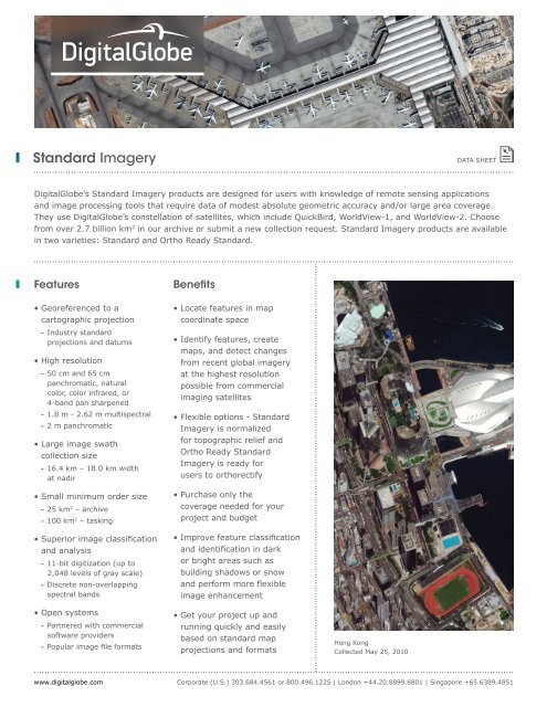
Hong Kong<br />
Collected May 25, 2010<br />
DATA SHEET<br />
Corporate (U.S.) 303.684.4561 or 800.496.1225 | London +44.20.8899.6801 | Singapore +65.6389.4851
<strong>Standard</strong> <strong>Imagery</strong><br />
Specifications<br />
Product Options<br />
* All four bands delivered in a single file<br />
** Up to 30° off nadir<br />
U.S. Regulation requires imagery to be resampled to a minimum of .50 m pan and 2.0 m multispectral.<br />
www.digitalglobe.com<br />
Pixel Resolution* Image Bands<br />
Panchromatic 50 cm, 60 cm, 2.0 m Panchromatic<br />
Multispectral (4-band) * 2.0 m, 2.4 m Blue, Green, Red, NIR1<br />
Multispectral (8-band) 2.0 m<br />
Coastal, Blue, Green, Yellow,<br />
Red, Red Edge, NIR1, NIR2<br />
Bundle (pan + 4-band) 50 cm, 60 cm Panchromatic<br />
2.0 m, 2.4 m Blue, Green, Red, NIR1<br />
Bundle (pan + 8-band) 50 cm Panchromatic<br />
2.0 m<br />
Coastal, Blue, Green, Yellow,<br />
Red, Red Edge, NIR1, NIR2<br />
Natural Color 50 cm, 60 cm Blue, Green, Red<br />
Color Infrared 50 cm, 60 cm Green, Red, NIR1<br />
4-band Pan Sharpened 50 cm, 60 cm Blue, Green, Red, NIR1<br />
Spectral Characteristics (nanometers)<br />
QuickBird<br />
WorldView-1<br />
WorldView-2<br />
Coastal Blue Green Yellow Red Red<br />
Edge<br />
396-<br />
458<br />
430-<br />
545<br />
442-<br />
515<br />
Image Accuracy Specifications<br />
466-<br />
620<br />
506-<br />
586<br />
584-<br />
632<br />
590-<br />
710<br />
624-<br />
694<br />
699-<br />
749<br />
Near-<br />
IR1<br />
QuickBird 23 m CE90<br />
WorldView-1 and WorldView-2 **<br />
715-<br />
918<br />
765-<br />
901<br />
5.0 m CE90<br />
Near-<br />
IR2<br />
856-<br />
1043<br />
Processing <strong>Standard</strong> Ortho Ready <strong>Standard</strong><br />
Applied Corrections Radiometric, sensor, and geometric corrections<br />
Mapped to a cartographic projection<br />
Geometric Corrections Projected to a plane using map<br />
projection and datum, coarse<br />
DEM applied to normalize for<br />
topographic relief<br />
Order Parameters<br />
Product Type Panchromatic, Multispectral, or Bundle; Natural<br />
Color; Color Infrared; 4-band Pan Sharpened<br />
Image Bits / Pixel 8 or 16 bits<br />
File Formats GeoTIFF 1.0, NITF 2.1, NITF 2.0<br />
Pan<br />
(B&W)<br />
405-<br />
1053<br />
397-<br />
905<br />
447-<br />
808<br />
Projected to a plane using map<br />
projection and datum, projected<br />
to a constant base elevation to<br />
allow for orthorectification<br />
Deliverables<br />
<strong>Standard</strong> <strong>Imagery</strong> can be acquired directly from<br />
the <strong>DigitalGlobe</strong> archive or you can submit a<br />
new collection request. <strong>Standard</strong> <strong>Imagery</strong> is<br />
ordered by area, with a minimum purchase of<br />
25 km 2 for archive or 100 km 2 tasking orders,<br />
up to a maximum of 10,000 km 2 per order.<br />
If your order crosses more than one strip,<br />
one standard imagery product per scene is<br />
delivered. Products are delivered on your choice<br />
of standard digital media with Image Support<br />
Data files including image metadata.<br />
Delivery Methods<br />
Media Delivery: DVD<br />
DS-STAND Rev 01/13<br />
DATA SHEET<br />
Web-Based Delivery: FTP<br />
Corporate (U.S.) 303.684.4561 or 800.496.1225 | London +44.20.8899.6801 | Singapore +65.6389.4851