Gold! - Colorado Geological Survey
Gold! - Colorado Geological Survey
Gold! - Colorado Geological Survey

Create successful ePaper yourself
Turn your PDF publications into a flip-book with our unique Google optimized e-Paper software.
<strong>Colorado</strong> <strong>Geological</strong> <strong>Survey</strong> ROCKTALK Vol. 6, No. 2<br />
Division of Minerals and Geology<br />
<strong>Colorado</strong> <strong>Geological</strong> <strong>Survey</strong><br />
Volume 6, Number 2 April 2003<br />
<strong>Gold</strong>! <strong>Gold</strong>! <strong>Gold</strong>!<br />
CAMP BIRD GOLD MILL<br />
GOLD<br />
Just the mention of that<br />
word whets the appetite for<br />
riches, adventure, and the<br />
excitement of discovery. Men<br />
have been giving up the comforts<br />
of home to search for gold<br />
since before recorded history.<br />
They have climbed over vast<br />
and imposing mountain ranges,<br />
suffered the biting blasts of the<br />
arctic, fought through disease<br />
infested jungles, and wandered<br />
across parched and lonely deserts<br />
all for gold, the most beautiful<br />
and most desired of all metals.<br />
<strong>Gold</strong> has been treasured<br />
since prehistoric times. <strong>Gold</strong><br />
artifacts are found in some of<br />
the earliest archeological sites.<br />
The earliest known geological<br />
map is Egyptian, and it dates<br />
from about 3,300 years ago. The<br />
map depicts “mountains of<br />
INSIDE<br />
Publications_________________13<br />
The Rock Doctor Asks ________13<br />
San Luis Valley Science Fair ___13<br />
Geosciences Critical to<br />
<strong>Colorado</strong>’s Future ___________14<br />
CGS Celebrates a Decade<br />
of Excellence________________14<br />
Book Review________________16<br />
DENVER PUBLIC LIBRARY<br />
gold” and shows areas where<br />
gold was recovered and where<br />
miners lived. No one is sure of<br />
the exact location of this ancient<br />
mine; however, it may be in the<br />
Red Sea Hills near the present<br />
day Suez Canal.<br />
What is it about gold that<br />
makes it so attractive and so<br />
useful? <strong>Gold</strong> is not very hard; a<br />
knife can easily scratch pure<br />
gold. <strong>Gold</strong> is very heavy or<br />
dense, having a specific gravity<br />
of 19.3+ (extremely heavy even<br />
for metallic minerals). Some of<br />
the other characteristics of gold<br />
are ductility, malleability and<br />
sectility, meaning it can be<br />
stretched into a wire, pounded<br />
into other shapes, and cut into<br />
slices. <strong>Gold</strong> is the most ductile<br />
and malleable element on our<br />
planet. A single ounce of gold<br />
can be drawn into a wire 35<br />
miles long and it can be hammered<br />
into sheets less than five<br />
millionths of an inch thick. <strong>Gold</strong><br />
is a great metal for jewelry, as it<br />
never tarnishes.<br />
The color and luster of gold<br />
are what make this metal so<br />
attractive. <strong>Gold</strong> is almost indestructible<br />
and has been used and<br />
reused for centuries, to the<br />
extent that all of the gold that is<br />
currently being used by mankind<br />
is almost equal to all the gold<br />
that has ever been mined.<br />
When we think of gold our<br />
first thoughts go to jewelry and<br />
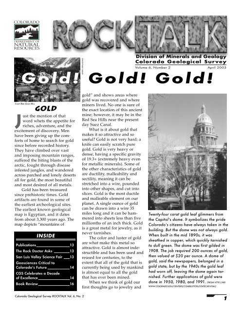
Twenty-four carat gold leaf glimmers from<br />
the Capitol’s dome. It symbolizes the pride<br />
<strong>Colorado</strong>’s citizens have always taken in the<br />
building. But the dome was not always gold.<br />
When built in the mid 1890s, it was<br />
sheathed in copper, which quickly tarnished<br />
to dull green. The dome was first gilded in<br />
1908. The job required 200 ounces of gold,<br />
then valued at $20 per ounce. A dome of<br />
gold, said the newspapers, belonged in a<br />
gold state, but by the 1940s the gold leaf<br />
had worn off, leaving the dome again tarnished.<br />
Further applications of gold were<br />
done in 1950, 1980, and 1991. (FROM HTTP://ME-<br />
WWW.COLORADO.EDU/CENTERS/COMBUSTION/STATECAP.HTML)<br />
1
other ornamentations made from<br />
gold. In today’s modern high tech<br />
economy gold has found other<br />
uses as well. <strong>Gold</strong> has superior<br />
electrical conductivity, resistance<br />
to corrosion, and other desirable<br />
combinations of physical and<br />
chemical properties that have<br />
allowed it to become an essential<br />
industrial metal. <strong>Gold</strong> performs<br />
critical functions in computers,<br />
communications equipment, spacecraft,<br />
jet aircraft engines, airbags in<br />
automobiles, and a host of other<br />
products. <strong>Gold</strong> has been used for<br />
many years in dentistry, mainly<br />
because of its lack of reactivity<br />
with other materials. <strong>Gold</strong> is also<br />
used in custom paints; the dome<br />
of the <strong>Colorado</strong> State Capitol<br />
building is painted with a special<br />
gold paint. <strong>Gold</strong> is also perceived<br />
to be the one commodity that is a<br />
long-term store of value. Until<br />
recent times, it was considered<br />
essentially a monetary metal, and<br />
most of the bullion produced each<br />
year went into the vaults of government<br />
treasuries or central<br />
banks.<br />
There are very few true gold<br />
minerals besides native gold. <strong>Gold</strong><br />
forms a major part of only a few<br />
rare minerals; it is found as little<br />
more than a trace in a few others,<br />
or it is alloyed to a small extent<br />
with other metals such as silver<br />
and copper. A few of the minerals<br />
that bear gold in their respective<br />
formulae are in a class of minerals<br />
called the tellurides. The element<br />
gold seems to have an affinity for<br />
tellurium and is one of the only<br />
elements that gold can bond with<br />
easily.<br />
<strong>Gold</strong>-silver alloys usually have<br />
a whiter color than pure gold, and<br />
gold-copper alloys tend to have a<br />
slight reddish tint. The gold content<br />
of a gold alloy is measured in<br />
karats; 24 karat is 100 percent, 18<br />
karat is 75 percent gold and 25<br />
percent other metals, and 14 karat<br />
is 58 percent gold and 42 percent<br />
other metals.<br />
2<br />
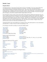
<strong>Gold</strong> in <strong>Colorado</strong>:<br />
a a Brief History<br />
Black Hawk<br />
Idaho Springs<br />
<strong>Gold</strong>en<br />
The first documented report of<br />
gold in <strong>Colorado</strong> was in 1803<br />
by an explorer named James<br />
Purcell who collected some gold<br />
nuggets along the South Platte<br />
River. Through the 1830s and<br />
1840s there were sporadic and<br />
ill-defined reports of gold in<br />
Clear Creek<br />
Significant gold<br />
placer deposit<br />
<strong>Colorado</strong> from trappers and other adventurers.<br />
The great California gold rush of 1849 opened up the<br />
opportunity for gold seekers to pass through the Rocky<br />
Mountains. A party of prospectors from Auraria, Georgia<br />
(a settlement in the Dahlonega gold district in Georgia)<br />
passed through <strong>Colorado</strong> on their way to the California gold<br />
fields and noted that there was potential for gold deposits in the<br />
streams flowing out of the Front Range. After finding only disappointment<br />
and little gold in California, the Georgians under<br />
the direction of William Russell, John Beck, and Lewis Ralston<br />
returned to <strong>Colorado</strong> in 1858 and began prospecting for<br />
gold along the South Platte River, Cherry Creek, and Clear<br />
Creek near the present site of Denver. They settled on the<br />
south side of Cherry Creek near the confluence of the South<br />
Platte River. In remembrance of their home in Georgia, they<br />
named the settlement Auraria (today the home of the Auraria<br />
campus of CU Denver, Metropolitan State College, and the Tivoli Brewery).<br />
Through 1858 and early 1859 these prospectors and others found<br />
gold in these streams but never a rich amount-always just a tease. The<br />
local prospectors and their financial backers in the east were beginning to<br />
think that the Pikes Peak <strong>Gold</strong> Rush (as it was called, even though it was<br />
nowhere near Pikes Peak) was a bust!!<br />
In the late summer of 1859, George Jackson, another prospector from<br />
Georgia, began prospecting along Clear Creek near the present site of the<br />
city of <strong>Gold</strong>en (oddly <strong>Gold</strong>en is not named for gold, but for a man named<br />
South<br />
DENVER<br />
Auraria<br />
PlatteRiver<br />
Cherry Creek<br />
Parker<br />
Franktown<br />
Russelville<br />
First gold<br />
discovered<br />
<strong>Colorado</strong> <strong>Geological</strong> <strong>Survey</strong> ROCKTALK Vol. 6, No. 2<br />
COLORADO HISTORICAL SOCIETY
Tom <strong>Gold</strong>en, an early prospector).<br />
Jackson found significant amounts<br />
of gold as he continued up Clear<br />
Creek until he discovered and<br />
starting mining the rich placer*<br />
deposits where Chicago Creek joins<br />
Clear Creek near Idaho Springs.<br />
Later that same year, another<br />
Georgia prospector, John Gregory,<br />
prospected for gold along Clear<br />
Creek and then up the North Fork<br />
to the present site of Blackhawk.<br />
There he found an outcropping<br />
quartz vein with gold, the first<br />
“lode”* gold discovery in <strong>Colorado</strong>,<br />
which led to the development of<br />
the Blackhawk–Central City<br />
mining district. During that year<br />
and in 1860, gold was discovered<br />
in many locations throughout the<br />
state including Boulder Creek,<br />
Nederland, Breckenridge, Silverton,<br />
Telluride, Leadville, and other<br />
famous <strong>Colorado</strong> mining sites.<br />
Leadville<br />
The discovery of gold near<br />
Leadville in the gravel deposits of<br />
California Gulch lead to a short<br />
lived placer gold boom in that<br />
area. The discovery of veins with<br />
large masses of free gold at the<br />
Printer Boy Mine in 1868 helped<br />
extend the life of the camp, but did<br />
not reverse the trend of declining<br />
production. One of the problems<br />
* See Definitions on page 12<br />
<strong>Gold</strong> Production in <strong>Colorado</strong> 1858—2001<br />
Production in 1,000 Ounces<br />
1,600<br />
1,400<br />
1,200<br />
1,000<br />
800<br />
600<br />
400<br />
200<br />
0<br />
Discovery of<br />
Cripple Creek<br />
district<br />
<strong>Colorado</strong> <strong>Geological</strong> <strong>Survey</strong> ROCKTALK Vol. 6, No. 2<br />
the placer miners encountered was<br />
a strange brown material that kept<br />
clogging up the gold placer mining<br />
operations. In 1874 the brown<br />
material was recognized as a silver–<br />
lead ore and the great lead–zinc–<br />
silver-gold deposits of the<br />
Leadville district were quickly discovered<br />
and developed.<br />
During the 1860s, most all of<br />
<strong>Colorado</strong>’s easily mined gold<br />
deposits, placer and oxidized gold<br />
lode deposits were exploited. As<br />
the 1870s and 1880s came to a<br />
close, new processing techniques<br />
allowed the development of underground<br />
lode gold mines throughout<br />
the state. During these years<br />
silver, especially in the Alma district,<br />
Leadville district, and San<br />
Juan Mountains, became the dominant<br />
commodity mined in <strong>Colorado</strong>.<br />
<strong>Gold</strong> mining suffered and the<br />
huge bonanza gold district eluded<br />
detection, that is until 1891.<br />
Cripple Creek<br />
Early reports of gold in the area<br />
around Pikes Peak in 1874 and<br />
1884 never “panned out”(a common<br />
expression related to gold<br />
prospecting). In 1891, a local<br />
rancher named Robert Womack<br />
made a gold discovery in Poverty<br />
Gulch, just east of the present day<br />
town of Cripple Creek, and located<br />
the El Paso claim. This claim was<br />
later developed into the <strong>Gold</strong> King<br />
<strong>Gold</strong> Production Price, $/ounce<br />
<strong>Gold</strong> mine<br />
closure for<br />
World War II<br />
Mine, the first of a series of gold<br />
discoveries that led to the rapid<br />
development of the Cripple Creek<br />
district. The rich underground<br />
mines in the early years of the district’s<br />
history had an average grade<br />
of 1 to 2 ounces of gold per ton.<br />
The Cripple Creek District has<br />
produced more than 23 million<br />
ounces of gold, about half of<br />
<strong>Colorado</strong>’s total production of 45<br />
million ounces. In the peak year of<br />
production, 1900, 879,000 ounces of<br />
gold were produced. By 1920 production<br />
from the district had<br />
started to decline because of labor<br />
shortages, wage disputes, and<br />
water problems.<br />
In 1933, the price of gold<br />
increased from $20.67 to $35.00 an<br />
ounce, which fostered a small mining<br />
boom in the state until the outbreak<br />
of World War II and the<br />
closure of all non-essential mines<br />
by the War Production Board. <strong>Gold</strong><br />
mining in <strong>Colorado</strong> languished in<br />
the years after World War II, primarily<br />
because of the low price of<br />
gold.<br />
All restrictions on the price of<br />
gold were lifted during the mid-<br />
1970s and interest focused on low<br />
grade (0.03 to 0.2 ounces of gold<br />
per ton) bulk-tonnage gold<br />
deposits. <strong>Gold</strong> production began to<br />
steadily increase during the 1980s<br />
and 1990s from deposits located<br />
near Silverton at the Sunnyside<br />
Modern<br />
resurgence of<br />
gold mining<br />
800<br />
700<br />
600<br />
500<br />
400<br />
300<br />
200<br />
100<br />
0<br />
Price Per Ounce in Dollars<br />
3
4<br />
how to order<br />
CGS publications<br />
Mail:<br />
<strong>Colorado</strong> <strong>Geological</strong> <strong>Survey</strong>,<br />
1313 Sherman Street,<br />
Room 715, Denver, CO 80203<br />
Phone: (303) 866-2611<br />
New CGS Website address:<br />
http://geosurvey.state.co.us<br />
Fax: (303) 866-2461<br />
E-mail:<br />
cgspubs@state.co.us<br />
VISA® and MasterCard®<br />
accepted.<br />
Prepayment required.<br />
SHIPPING AND HANDLING<br />
Please contact the CGS for<br />
shipping and handling costs.<br />
Discounts<br />
Available on bulk orders.<br />
Call for a complete<br />
publication list<br />
Mentioned in This Issue<br />
IS 33<br />
<strong>Gold</strong> Panning and Placering In <strong>Colorado</strong>:<br />
How and Where $12.00<br />
IS 63<br />
<strong>Colorado</strong> Mineral and Mineral Fuel<br />
Activity, 2001 $6.00<br />
MS 28<br />
Location Map and Descriptions of Metal<br />
Occurrences in <strong>Colorado</strong> with Notes on<br />
Economic Potential $10.00<br />
RS 28<br />
<strong>Gold</strong> Occurrences of <strong>Colorado</strong> $14.00<br />
RS 35<br />
Alkalic Igneous Rocks of <strong>Colorado</strong> and<br />
Their Associated Ore Deposits $12.00<br />
RS 37<br />
Geology and Mineral Resources of<br />
Gunnison County, <strong>Colorado</strong> $18.00<br />
RS 40<br />
Geology and Mineral Resources of Park<br />
County, <strong>Colorado</strong> $30.00<br />
SP 53<br />
Ground Water Atlas of <strong>Colorado</strong> $40.00<br />
Mine, near Ouray at the Camp<br />
Bird Mine, the Summitville Mine<br />
in the San Juan Mountains, the<br />
Globe Hill and Iron Clad mines in<br />
the Cripple Creek district, and the<br />
San Luis <strong>Gold</strong> Mine in the Sangre<br />
de Cristo Mountains.<br />
<strong>Gold</strong> mining still continues<br />
today in the Cripple Creek District<br />
with the 1995 development of the<br />
Cresson surface mine by the<br />
Cripple Creek & Victor <strong>Gold</strong> Mining<br />
Company (CC&V), which is a<br />
joint venture between Anglo<strong>Gold</strong><br />
(<strong>Colorado</strong>) Corp. (67%) and <strong>Gold</strong>en<br />
Cycle <strong>Gold</strong> Corporation (33%).<br />
The operation has produced 1.62<br />
million gold ounces since early<br />
1995. The project employs over<br />
300 people and is currently accelerating<br />
production to over 400,000<br />
gold ounces per year.<br />
Geology of <strong>Gold</strong> Deposits<br />
in <strong>Colorado</strong><br />
The <strong>Colorado</strong> Mineral Belt played an important role in the distribution<br />
of the different types mineral deposits in <strong>Colorado</strong>. Most of<br />
<strong>Colorado</strong>’s gold deposits are within the <strong>Colorado</strong> Mineral Belt<br />
with one rather important exception. The <strong>Colorado</strong> Mineral Belt (page 5)<br />
was recognized early in the development of <strong>Colorado</strong>’s mineral exploration<br />
history. Josiah Spurr, in his 1908 study of the Georgetown—Silver<br />
Plume area, was the first scientist to recognize and publish the observation<br />
that mining districts in <strong>Colorado</strong> tended to line up in a northeasterly<br />
direction.<br />
Later workers came to realize that this northeasterly-trending zone<br />
was, in fact, a zone of fracturing and igneous intrusion that formed during<br />
the Laramide Orogeny* (about 75 million years to 40 million years ago).<br />
These intrusions and fractures are thought to follow a much older, Precambrian<br />
age zone of crustal weakness and shearing. Most of <strong>Colorado</strong>’s<br />
vein, placer, and replacement ore bodies occur within the bounds of the<br />
<strong>Colorado</strong> Mineral Belt. However, it should be noted that <strong>Colorado</strong>’s<br />
greatest gold producing district, the Cripple Creek district, is well outside<br />
of the <strong>Colorado</strong> Mineral Belt and is some 10 million years younger<br />
than the mineral deposits related to the Laramide Orogeny.<br />
All of the lode* gold deposits described below commonly contain<br />
more than one type of gold deposit; for example, the massive sulfide<br />
replacement deposits of the Leadville district also contain vein deposits.<br />
Vein Deposits<br />
Ore-bearing veins are open-space fillings along fractures or fault zones in<br />
the country rock. Veins usually consist of some non-ore mineral material<br />
(gangue), like quartz or calcite, and ore minerals like gold, silver, and base<br />
metal (lead, zinc, copper, and iron) sulfides.<br />
Quartz-base metal-gold veins are the most common type of ore body<br />
in the mining districts of the Front Range of <strong>Colorado</strong>. Here, the veins<br />
generally fill north-northeast to east-trending fractures and faults in Precambrian<br />
igneous and metamorphic rocks and, locally, a type of<br />
Laramide Orogeny-age, igneous rock called porphyry*. Veins generally<br />
<strong>Colorado</strong> <strong>Geological</strong> <strong>Survey</strong> ROCKTALK Vol. 6, No. 2
Important<br />
<strong>Gold</strong> and silver<br />
Occurrences<br />
MESA<br />
M ONTROSE ROSE<br />
SAN MIGUEL EL<br />
DOLORES<br />
MONTEZUMA<br />
of<br />
<strong>Colorado</strong><br />
Important gold occurrence<br />
Other occurrence<br />
GARFIELD<br />
RFIELD<br />
DELTA DELTA<br />
OURAY OURAY<br />
Sneffels<br />
Telluride<br />
Silverton<br />
Rico<br />
SAN SAN<br />
JUAN JUAN<br />
La Plata<br />
LA PLATA<br />
GUNNISON<br />
GUNNISON<br />
HINSDALE<br />
HINSDALE<br />
MINERAL MINERAL<br />
ARCHULETA<br />
are a few thousand feet in length; the longest vein in<br />
the Central City district is the California-Mammoth<br />
vein, which is over two miles in length. Veins in the<br />
Central City district vary in width from a few inches<br />
to about 40 feet (at right). The veins “pinch out”<br />
at depths of 1,000 to 2,000 feet below the surface.<br />
Ore from the Mammoth Vein is typical of the<br />
district; gold contents ranged from 0.5 to 26<br />
ounces per ton; silver ranged from 1.5 to<br />
hundreds of ounces per ton. Most of the goldbearing<br />
veins of the Front Range mining<br />
districts also produced considerable amounts of<br />
lead, zinc, and copper.<br />
The spectacular San Juan Mountains of<br />
southwestern <strong>Colorado</strong> also contain several<br />
mining districts that have gold-base metal veins;<br />
however, in this area the veins are related to the<br />
development of a post-Laramide Orogeny-age<br />
volcanic field. Most of the veins are related to<br />
post-eruption subsidence of volcanoes, called<br />
calderas (next page). Some of the better known<br />
mining districts of the San Juan Mountains<br />
<strong>Colorado</strong> <strong>Geological</strong> <strong>Survey</strong> ROCKTALK Vol. 6, No. 2<br />
ROUTT ROUTT<br />
EAGLE EAGLE E<br />
PITKIN PITKIN<br />
JACKSON<br />
GG RR AND AND<br />
SUMMIT SUMMIT<br />
LAKE LAKE<br />
CHAFFEE CHAFFEE<br />
SAGUACHE<br />
SAGUACHE<br />
RIO RIO<br />
GRANDE GRANDE<br />
CONEJOS<br />
LARIMER<br />
GILPIN GILPIN<br />
CLEAR CLEAR<br />
CREEK CREEK<br />
PARK PARK<br />
ALAMOSA ALAMOSA<br />
BOULDER BOULD<br />
JEFFERSON<br />
JEFF<br />
TELLER T<br />
FREMONT<br />
FREMON<br />
CUSTER CUST<br />
ADAMS<br />
ARAPAHOE<br />
EL<br />
PASO<br />
PUEBLO<br />
HUERFANO<br />
include Silverton, Creede, Summitville,<br />
Telluride, Lake City, and<br />
Imogene Basin (near Ouray). Most<br />
of the mining camps of the San<br />
Juan Mountains produced considerably<br />
more silver than gold;<br />
however, gold was the most<br />
important mineral, economically.<br />
Veins in the San Juan Mountains<br />
have lengths up to about<br />
9,000 feet, with depths to over<br />
2,500 feet. Vein widths average<br />
three to six feet; the largest are up<br />
to 50 feet wide.<br />
Gangue minerals in the veins<br />
of the San Juans include quartz,<br />
calcite, barite, fluorite, and a rich<br />
variety of manganese minerals<br />
including rhodochrosite (the new<br />
State Mineral), rhodonite, and<br />
others.<br />
Ore minerals include the base<br />
metal sulfides: pyrite, sphalerite,<br />
galena, tennantite, and chalcopyrite.<br />
<strong>Gold</strong> is generally associated<br />
with the pyrite and chalcopyrite<br />
and most of the silver is associated<br />
with tennantite.<br />
Replacement<br />
Deposits<br />
Replacement deposits are, for the<br />
most part, hosted by Paleozoic-age<br />
carbonate rocks, limestone and dolomites. The<br />
replacement ore bodies are composed of zones of<br />
almost entirely sulfide minerals (called massive<br />
sulfide deposits), usually galena, sphalerite, pyrite,<br />
COSTILLA<br />
COSTILL<br />
WELD<br />
Caribou <strong>Gold</strong> Hill<br />
Central<br />
City Idaho<br />
Springs<br />
Breckenridge<br />
Montezuma<br />
Leadville<br />
Alma<br />
Gunnison<br />
<strong>Gold</strong> Belt<br />
Creede<br />
Whitepine<br />
Bonanza<br />
Summitville<br />
DEN<br />
DOUGLAS<br />
Cripple<br />
Creek<br />
Silver Cliff<br />
Rosita Hills<br />
San Luis<br />
Precambrian<br />
metamorphic<br />
rocks<br />
Typical gold vein<br />
LAS<br />
ANIMAS<br />
Zones of pyrite-gold<br />
enrichment in quartz<br />
Vein<br />
3 ft<br />
vein<br />
Mostly<br />
quartz<br />
Precambrian<br />
metamorphic<br />
rocks<br />
Altered<br />
metamorphic<br />
rocks<br />
5
and others. Gangue minerals are minor and consist<br />
mostly of quartz and calcite. Silver is commonly associated<br />
with galena and gold is commonly associated<br />
with pyrite. Most of the replacement deposits in <strong>Colorado</strong><br />
are associated with Laramide Orogeny-age porphyry<br />
intrusions. They include the Leadville district,<br />
the Aspen district, the Gilman district, and the La<br />
Plata district in the southwestern corner of <strong>Colorado</strong>.<br />
Only the Leadville district and the Gilman district produced<br />
significant amounts of gold from replacement<br />
deposits..<br />
The Leadville district is noted for six types of<br />
mineral deposits:<br />
1) Zinc-lead-silver-gold replacement bodies have<br />
typical grades of 0.05–0.2 ounces of gold per<br />
ton, 2-6 ounces of silver per ton, 3–8 percent<br />
lead, 6–30 percent zinc, and 0.1–0.3 percent<br />
copper;<br />
2) Quartz-base metal veins have typical grades of<br />
0.1–0.5 ounces of gold per ton, 2-13 ounces of<br />
silver per ton, 5–15 percent lead, and 4-10 percent<br />
zinc;<br />
3) Magnetite-serpentine-gold replacement bodies<br />
have average grades of 0.06–0.17 ounces of<br />
gold per ton, 2–4 ounces of silver per ton, and<br />
some copper;<br />
4) Quartz-pyrite-gold veins have average grades<br />
of 0.5 ounces of gold per ton, 30–40 ounces of<br />
silver per ton;<br />
5) Disseminated pyrite-gold in igneous intrusions,<br />
mainly porphyritic rocks, have historic<br />
grades of 0.15–0.9 ounces of gold per ton;<br />
6) Placer gold.<br />
6<br />
H 2O convection<br />
Hot springs<br />
Au > Ag<br />
Precious<br />
metal<br />
rich<br />
Base<br />
metal<br />
and<br />
Ag-rich<br />
Hot igneous rocks<br />
Subvolcanic<br />
basement<br />
Linear veins<br />
Magma-generated<br />
hydrothermal<br />
fluids<br />
Cross section of a volcano showing collapsing caldera and relationship<br />
of precious metal vein deposits —ADAPTED FROM GUILBERT AND PARK, 1985, P. 537<br />
Stratabound <strong>Gold</strong>-<br />
Sulfide Deposits<br />
Disseminated gold and base metal mineralization<br />
occurs along structures or other zones<br />
that are parallel to foliation or original bedding<br />
in Precambrian age metamorphic rocks<br />
in several areas of the state, including the<br />
Pearl district in Jackson County, the Salida<br />
area of Chaffee County, and the “Gunnison<br />
<strong>Gold</strong> Belt” in Gunnison County.<br />
These types of deposits never produced<br />
much gold in <strong>Colorado</strong>; however, they<br />
remain an intriguing target for gold prospectors,<br />
especially in other parts of the world.<br />
<strong>Gold</strong> Deposits<br />
in Alkalic Volcanic Rocks<br />
Alkalic igneous rocks form a unique suite of<br />
rocks that are depleted in silica and relatively<br />
enriched in sodium and potassium compared<br />
to other igneous rocks. The Cripple Creek<br />
district is located within a small (approximately six<br />
square miles) 32–28 million year old alkalic intrusivediatreme<br />
complex emplaced at the junction of four<br />
Precambrian igneous and metamorphic units.<br />
Diatremes are neck-like volcanic features composed of<br />
breccia formed by the explosive activity that results<br />
when molten rock interacts with abundant groundwater<br />
near the surface. The complex consists primarily of<br />
a large mass of phonolite, an alkalic igneous rock, and<br />
Just a few of the many minerals associated with gold<br />
deposits in <strong>Colorado</strong> and elsewhere.<br />
Mineral Chemical Chemical<br />
Name Composition Name<br />
Quartz SiO2 Silicon dioxide<br />
Calcite CaCO3 Calcium carbonate<br />
Fluorite CaF2 Calcium fluoride<br />
Rhodonite MnSiO3 Manganese silicate<br />
Rhodochrosite MnCO3 Manganese carbonate<br />
Pyrite FeS2 Iron sulfide<br />
Sphalerite ZnS Zinc sulfide<br />
Galena PbS Lead sulfide<br />
Chalcopyrite<br />
Tennantite<br />
CuFeS2 3CuS2.As2S3 Copper-iron sulfide<br />
Copper sulfide–arsenic<br />
sulfide<br />
Calaverite AuTe2 <strong>Gold</strong> telluride<br />
Sylvanite (Au,Ag)Te2 <strong>Gold</strong>-silver telluride<br />
Petzite (Ag,Au)Te2 Silver-gold telluride<br />
<strong>Colorado</strong> <strong>Geological</strong> <strong>Survey</strong> ROCKTALK Vol. 6, No. 2
phonolite breccia. There are also lake sediments, tree<br />
trunks, and coal layers within parts of the complex,<br />
which indicate that these igneous rocks formed a<br />
small volcanic center at the surface.<br />
Because of their unique composition, ore deposits<br />
associated with alkalic igneous rocks have distinctive<br />
set of gangue and ore minerals. The principal ore minerals<br />
in the Cripple Creek district are gold telluride<br />
minerals: calaverite, and rarely sylvanite and petzite.<br />
Calaverite from district mines contains 39 percent to<br />
43 percent gold and minor amounts of silver.<br />
The Cripple Creek district is in Teller County, well<br />
south of the <strong>Colorado</strong> Mineral Belt. The district is the<br />
most important gold-producing camp in the state; it<br />
has produced more than 23 million ounces of gold<br />
since its discovery in 1891. In comparison, the entire<br />
state of <strong>Colorado</strong> has produced about 45 million ounces.<br />
Four main types of ore deposits are found within<br />
the Cripple Creek district: vein deposits, diatremehosted<br />
deposits, hydrothermal breccia-hosted<br />
deposits, and bedded rock-hosted deposits.<br />
Vein Deposits<br />
The vein and fissure vein deposits of the Cripple Creek<br />
district were the first discovered. The veins generally<br />
dip steeply and show a general radial pattern within<br />
the district. The veins of the district range from simple<br />
fissure fillings less than an inch thick to sheeted zones<br />
that are several feet, and as much as 100 feet, in width.<br />
The Ajax vein system is typical of the district; the Ajax<br />
vein is exposed throughout a vertical range of greater<br />
than 3,000 feet with virtually no change in ore grade<br />
or mineralogy. The Ajax Mine began production in<br />
Different types of<br />
placer deposits<br />
Stream<br />
<strong>Colorado</strong> <strong>Geological</strong> <strong>Survey</strong> ROCKTALK Vol. 6, No. 2<br />
Alluvial<br />
placers<br />
Gulch<br />
placers<br />
Colluvial<br />
placers<br />
placers<br />
Alluvial placers<br />
1895 and produced more than 700,000 ounces of gold<br />
at grades of 0.6 to 1.04 ounces per ton.<br />
Diatreme-hosted Deposits<br />
The most economically significant diatreme-hosted<br />
deposit in the Cripple Creek district was the Cresson<br />
Mine. It yielded 28.3 million tons of ore at a grade of<br />
0.55 ounces of gold per ton from 1904 to 1959. The<br />
mine’s production of over 15 million ounces of gold<br />
was about 70 percent of the district’s total production.<br />
In 1914 a very rich part of the deposit known as the<br />
Cresson Vug was discovered and during a period of<br />
four weeks it yielded approximately 58,000 ounces of<br />
gold from an open cavity 23 feet by 13 feet by 40 feet<br />
high.<br />
Hydrothermal Breccia Deposits<br />
The northern part of the Cripple Creek district is dominated<br />
by hydrothermal breccia gold deposits. These<br />
deposits consist of low grade, native gold ores within<br />
strongly altered and hydrothermal brecciated alkalic<br />
porphyry. The hydrothermal breccias of the Globe Hill<br />
and Ironclad deposits were mined during the period<br />
from 1992 to 1995 using modern surface mining techniques.<br />
Sedimentary Rock-hosted Deposits<br />
Lake and river sediments are common in the eastern<br />
part of the Cripple Creek intrusive-diatreme complex.<br />
Sedimentary rocks are found at the surface and in the<br />
deepest mine workings, 3,200 feet below the surface,<br />
indicating a substantial amount of subsidence within<br />
the complex. The Cameron Mine contains disseminated<br />
gold in sediments.<br />
Soil and mantle<br />
Placer Deposits<br />
A placer deposit is an accumulation of rock fragments<br />
formed by processes of sedimentation<br />
or weathering in which gold or other<br />
heavy minerals are concentrated<br />
by mechanical<br />
Bedrock<br />
gold<br />
deposit<br />
processes, such as<br />
gravity. Placer<br />
deposits occur in<br />
alluvial deposits of<br />
sand and gravel in<br />
modern day streams,<br />
older bench or terrace<br />
gravel deposits, alluvial fans,<br />
and deposits left or modified by<br />
glaciers. Other placer deposits include<br />
Zone of weathering<br />
eluvial, which are formed in soils by the<br />
weathering of bedrock (lode) gold deposits.<br />
Colluvial placer deposits occur by gold particles<br />
moving down slope solely by gravity, generally from<br />
eluvial gold deposits (left). The largest gold lode<br />
7
deposits in the world, the Witswatersrand<br />
in South Africa, were<br />
originally formed in alluvial beach<br />
placers during the early Precambrian<br />
(about 2,200 to 3,000 million<br />
years ago). These gravels were<br />
subsequently turned into hard rock<br />
by heat and pressure.<br />
In <strong>Colorado</strong> the most common<br />
type of gold placer deposits are<br />
alluvial deposits formed in the<br />
sand and gravel of modern day<br />
streams. In many cases older<br />
stream deposits called benches or<br />
terraces, which formed during the<br />
Quaternary Period (the last two<br />
million years) are also good hosts<br />
for placer gold deposits. The first<br />
gold discoveries in <strong>Colorado</strong> were<br />
placer deposits in and around the<br />
present site of Denver. Other<br />
notable placer mining areas in<br />
<strong>Colorado</strong> include Clear Creek<br />
from <strong>Gold</strong>en to Idaho Springs, the<br />
Blue River near Breckenridge, and<br />
the South Platte River near Fairplay.<br />
<strong>Gold</strong> from placer deposits has<br />
been recovered by a variety of<br />
methods including panning (below),<br />
sluice boxes, hydraulic mining,<br />
and dredging and drift mining.<br />
For a more complete description of<br />
these placer-mining methods<br />
please refer to Parker (1992).<br />
Prospector panning for gold —PHOTO<br />
FROM DENVER PUBLIC LIBRARY<br />
8<br />
Fairplay Dredge No. 1—PHOTO COURTESY COLORADO HISTORICAL SOCIETY, ZELLARS COLLECTION<br />
Economically significant placer<br />
mining in <strong>Colorado</strong> ended in 1951<br />
with the shutdown of the “Fairplay<br />
Dredge,” (above) a large<br />
dredging machine that recovered<br />
gold from the South Platte River<br />
near Fairplay.<br />
Even today, small amounts of<br />
gold are recovered from sand and<br />
gravel quarries along the South<br />
Platte River. Also, many people<br />
come to <strong>Colorado</strong> to do recreational<br />
gold panning; these modern day<br />
prospectors recover small amounts<br />
of gold. — Jim Cappa<br />
<strong>Colorado</strong>’s only active<br />
gold mine—<br />
Cripple Creek & & Victor <strong>Gold</strong> Mining Company<br />
The Cripple Creek & Victor<br />
<strong>Gold</strong> Mining Company is<br />
presently the only active<br />
large scale gold mining operation<br />
in <strong>Colorado</strong>. It is located 52 miles<br />
west of <strong>Colorado</strong> Springs near the<br />
historic gold mining towns of<br />
Cripple Creek and Victor. Anglo-<br />
<strong>Gold</strong> (<strong>Colorado</strong>) Corp. operates<br />
this large surface mine, which<br />
employs about 300 people and is<br />
the largest private employer in<br />
Teller County.<br />
Whereas the old-time miners in<br />
the area searched for and mined<br />
rich “high grade” gold ore from<br />
narrow veins, the modern mine<br />
takes advantage of new mining<br />
technology to extract gold remain-<br />
ing in the “low grade” ore that<br />
was left untouched by the oldtimers.<br />
Although the ore is not<br />
rich, there is a lot of it. At the<br />
beginning of 2002, geologists at the<br />
mine estimated a reserve of 157<br />
million tons of gold-bearing ore<br />
containing 5.0 million ounces of<br />
gold. The ore has an estimated<br />
average grade of only about 0.032<br />
ounces of gold per ton. Modernera<br />
surface mining began in the<br />
Cripple Creek district in 1991.<br />
Underground mining ceased in<br />
Cripple Creek in 1961, 70 years<br />
after the discovery of gold in the<br />
district. (left)<br />
In 2002, the Cripple Creek &<br />
Victor <strong>Gold</strong> Mining Company<br />
<strong>Colorado</strong> <strong>Geological</strong> <strong>Survey</strong> ROCKTALK Vol. 6, No. 2
The Cripple Creek & Victor gold mine. Note the drilling rigs forming a<br />
blasthole pattern in the bottom of the mine.<br />
Crushing and sorting facility, Cripple Creek & Victor <strong>Gold</strong> Mine<br />
<strong>Colorado</strong> <strong>Geological</strong> <strong>Survey</strong> ROCKTALK Vol. 6, No. 2<br />
produced 224,000 ounces of gold. In October<br />
2002, the company completed a major<br />
expansion of its production capability<br />
that will permit the mine production to<br />
ramp-up to 400,000 ounces of gold per<br />
year. At the expanded rate of production,<br />
the ore reserve base will support mining<br />
through 2012.<br />
Mining and Processing<br />
The low-grade gold ore at Cripple Creek<br />
& Victor is mined at a rate of about 55,000<br />
tons per day. The ore is blasted from<br />
active mining “benches” within the open<br />
pit and loaded by enormous shovels into<br />
giant trucks that can haul 310 tons of rock<br />
in a single load (below). The trucks deliver<br />
the raw ore to a crushing plant that<br />
Massive new truck at the Cripple Creek &<br />
Victor with the capacity to haul 310 tons of<br />
ore per load.<br />
crushes the rock to a specified mesh size,<br />
about 5 /8 inch in diameter. The crushed<br />
ore is then placed on a heap leach pad<br />
(page 10). A slow-drip system applies a<br />
solution of water and sodium cyanide to<br />
the ore. The cyanide solution soaks into<br />
the pad and dissolves the microscopic<br />
particles of gold within the ore. The<br />
cyanide solution is then collected at the<br />
base of the pad by a system of pipes and<br />
heavy liners. Care is taken to avoid any<br />
leaks of cyanide solution, not only to<br />
protect the groundwater, but to protect<br />
profits. Losing cyanide solution at this<br />
point means losing gold. After being collected,<br />
the gold-bearing cyanide solution<br />
is treated with activated carbon, which<br />
acts like a chemical sponge and reduces<br />
9
10<br />
State of <strong>Colorado</strong><br />
Bill Owens, Governor<br />
Department of Natural Resources<br />
Greg E. Walcher, Executive Director<br />
Division of Minerals and Geology<br />
Ronald W. Cattany, Director<br />
Natural Resource Trustee<br />
<strong>Colorado</strong><br />
<strong>Geological</strong> <strong>Survey</strong><br />
Ronald W. Cattany, Acting Director<br />
and State Geologist<br />
James A. Cappa, Mineral Resources<br />
Vince Matthews,<br />
Senior Science Advisor<br />
David C. Noe, Engineering Geology<br />
Randal C. Phillips, GIS and<br />
Technical Services<br />
Patricia Young, Administration<br />
and Outreach<br />
Matt Sares, Environmental Geology<br />
Knox Williams, <strong>Colorado</strong> Avalanche<br />
Information Center<br />
Administration and Outreach<br />
Betty Fox, Brenda Hannu,<br />
Melissa Ingrisano, Dori Vigil<br />
Avalanche Information Center<br />
Dale Atkins, Nick Logan, Scott Toepfer<br />
Mapping, Outreach, and Earthquakes<br />
John Keller, Bob Kirkham,<br />
Matt Morgan, Beth Widmann<br />
Engineering Geology and Land Use<br />
Karen Berry, Jill Carlson, Sean Gaffney,<br />
Celia Greenman, Jim Soule, T.C. Wait, Jon White<br />
Environmental Geology<br />
Peter Barkmann, David Bird, Ralf Topper,<br />
Bob Wood<br />
GIS and Technical Services<br />
Cheryl Brchan, Karen Morgan, Larry Scott,<br />
Jason Wilson<br />
Mineral Fuels<br />
Chris Carroll<br />
Minerals<br />
John Keller, Beth Widmann<br />
RockTalk is published by the<br />
<strong>Colorado</strong> <strong>Geological</strong> <strong>Survey</strong><br />
1313 Sherman Street,<br />
Room 715, Denver, CO 80203<br />
Back issues and subscriptions can<br />
be obtained FREE by contacting CGS<br />
or download them from our Web site<br />
Phone: (303) 866-2611<br />
Fax: (303) 866-2461<br />
E-mail: cgspubs@state.co.us<br />
Web site: http://geosurvey.state.co.us<br />
THIS ISSUE<br />
Editors: Jim Cappa, John Keller,<br />
Cheryl Brchan<br />
Production: Cheryl Brchan<br />
Heap leach pad with a drip system that gently applies a solution of water<br />
and sodium cyanide to crushed and screened gold ore at the Cripple Creek<br />
& Victor <strong>Gold</strong> Mine.<br />
Getting ready to pour gold at Cripple Creek & Victor <strong>Gold</strong> Mine<br />
<strong>Colorado</strong> <strong>Geological</strong> <strong>Survey</strong> ROCKTALK Vol. 6, No. 2
the gold out of the solution. The gold (along with a<br />
little silver) is then smelted into doré bars of crude<br />
metal, which is sent to a gold refinery in another state<br />
for purification. — John Keller<br />
References<br />
and Further Reading<br />
Boyle, R.W., 1987, <strong>Gold</strong>, history and genesis of deposits: New<br />
York, Van Nostrand Reinhold Co., 676 p.<br />
Boyle, R.W., 1979, The geochemistry of gold and its deposits:<br />
Canada <strong>Geological</strong> <strong>Survey</strong> Bulletin 280, 584 p.<br />
With<br />
the worst drought on<br />
record in 2002, water is<br />
a topic that gets a bit more attention<br />
throughout <strong>Colorado</strong> these days. Information<br />
on this subject is more sought<br />
after than ever. Now, the <strong>Colorado</strong><br />
<strong>Geological</strong> <strong>Survey</strong> delivers a benchmark<br />
publication, compiling basic ground-water<br />
information from an abundance of sources into<br />
one volume, the Ground Water Atlas of <strong>Colorado</strong>.<br />
The Ground Water Atlas of<br />
<strong>Colorado</strong> is a comprehensive, mapbased<br />
look at ground water in our<br />
state, an important part of the<br />
water resource picture. It summarizes<br />
the location, geography,<br />
geology, water quality, and hydrologic<br />
characteristics of the prominent<br />
aquifers in each part of <strong>Colorado</strong>.<br />
The large-format, full-color<br />
atlas was produced in cooperation<br />
with the <strong>Colorado</strong> Water Conservation<br />
Board and the Division of<br />
Water Resources.<br />
The Ground Water Atlas of<br />
<strong>Colorado</strong> presents ground water<br />
information in a way that is<br />
<strong>Colorado</strong> <strong>Geological</strong> <strong>Survey</strong> ROCKTALK Vol. 6, No. 2<br />
Cappa, J.A., 1998, Alkalic igneous rocks of <strong>Colorado</strong> and their<br />
associated ore deposits: <strong>Colorado</strong> <strong>Geological</strong> <strong>Survey</strong><br />
Resource Series 35, 138 p.<br />
Davis, M.W., and Streufert, R.K., 1990, <strong>Gold</strong> occurrences of<br />
<strong>Colorado</strong>: <strong>Colorado</strong> <strong>Geological</strong> <strong>Survey</strong> Resource Series 28,<br />
101 p.<br />
Guilbert, J.M., and Park, C.F., Jr., 1985, The geology of ore<br />
deposits: New York, W.H. Freeman and Co., 985 p.<br />
Parker, B.H., Jr., 1992, <strong>Gold</strong> panning and placering in <strong>Colorado</strong>:<br />
<strong>Colorado</strong> <strong>Geological</strong> <strong>Survey</strong> Information Series 33, 83 p.<br />
Vanderwilt, J.W., 1947, Mineral resources of <strong>Colorado</strong>: Denver,<br />
State of <strong>Colorado</strong> Mineral Resources Board, 547 p.<br />
Voynick, S.M., 1992, <strong>Colorado</strong> gold, from the Pikes Peak rush<br />
to the present: Missoula, Mont., Mountain Press Publishing<br />
Co., 206 p.<br />
Definitions<br />
(From Glossary of Geology,<br />
American <strong>Geological</strong> Institute)<br />
Ore deposit—Ore is defined as a naturally occurring<br />
material from which a mineral, or minerals, of<br />
economic value can be extracted.<br />
Grade—The relative quantity or percentage of ore<br />
mineral content in a body of rock. For gold usually<br />
expressed as ounces of gold per ton.<br />
Lode deposit—A mineral deposit in consolidated rock<br />
as opposed to most placer deposits which are in<br />
unconsolidated materials.<br />
approachable by laypersons as well as those well-versed in the subject. A multitude<br />
of maps, diagrams, pictures, tables, and graphs help make the technical aspects of<br />
ground water more understandable. With over 200 pages, the basic ground water<br />
information you need is probably covered.<br />
The Ground Water Atlas of <strong>Colorado</strong> (Special Publication 53) is now available at the<br />
<strong>Colorado</strong> <strong>Geological</strong> <strong>Survey</strong> at a cost of $40.00. Call (303) 866-2611 and order yours today!<br />
11
Argo <strong>Gold</strong> Mine and Mill (tour)<br />
Idaho Springs, <strong>Colorado</strong><br />
(303) 567 2421<br />
http://www.historicargotours.com/<br />
Bachelor Syracuse Mine (tour)<br />
Ouray<br />
970-325-0220<br />
http://www.ouraycolorado.com/activits.html<br />
Clear Creek Mining and Milling Museum<br />
23rd Avenue and Riverside Drive<br />
Idaho Springs<br />
Colo. School of Mines Geology Museum<br />
Currently in Berthoud Hall, CSM campus.<br />
Soon in new building!<br />
Phone: (303) 273-3823<br />
http://www.mines.edu/academic/geology/museum/<br />
Country Boy Mine (tour)<br />
542 French Gulch Road, Breckenridge<br />
970-453-4405<br />
http://www.summitnet.com/countryboymine/<br />
Cripple Creek District Museum<br />
5th and Bennett Avenues, Cripple Creek<br />
(719) 689-2634<br />
http://www.cripple-creek.co.us/ccdm.html<br />
Creede Underground Mining Museum<br />
(and tour)<br />
Creede<br />
719-658-0811<br />
http://www.museumtrail.org/CreedeUnd<br />
ergroundMiningMuseum.asp<br />
Denver Museum of Nature and Science<br />
2001 <strong>Colorado</strong> Blvd., Denver<br />
(303) 322-7009<br />
http://www.dmnh.org/<br />
Edgar Mine (tour)<br />
<strong>Colorado</strong> Avenue & 8th Street<br />
Idaho Springs<br />
(303) 567 2911<br />
http://www.mines.edu/Academic/mining/edgar.html<br />
12<br />
<strong>Colorado</strong> Mining and Mineral Museums<br />
and Mine Tours Orogeny—The process by which<br />
<strong>Colorado</strong>’s mining history has left a rich legacy. But, this legacy also<br />
includes 23,000 inactive and abandoned mines that can be as dangerous<br />
as they are picturesque. Mine sites may look safe to explore, but they<br />
often contain unstable soil, unsafe roofs and ladders, deadly gasses,<br />
poisonous snakes and dangerous explosives. The <strong>Colorado</strong> Division of<br />
Minerals and Geology asks you to “Stay Out and Stay Alive” and not<br />
explore abandoned mines but encourages you to learn more about mining<br />
and <strong>Colorado</strong>’s historic mining past by visiting a mining museum or<br />
tourist mine in <strong>Colorado</strong>.<br />
Gilpin County Historical Society and<br />
Museum<br />
228 High Street<br />
Central City, CO 80427<br />
(303) 582 5283<br />
http://www.coloradomuseums.org/gilpin.htm<br />
Hard Tack Mine (tour)<br />
Lake City<br />
970-944-2506<br />
http://www.lakecityco.com/lakecityRecre<br />
ation.html<br />
Hidee <strong>Gold</strong> Mine (tour, appointment only)<br />
County Rd. 6, Central City/Blackhawk<br />
303-989-2861<br />
Lafayette Miners’ Museum<br />
1087 E. Simpson Street<br />
Lafayette, CO 80026<br />
(303) 665 7030<br />
Lowell Thomas Museum<br />
3rd and Victor Avenue, Victor<br />
http://www.byways.org/image_library/<br />
media_details.html?CX_MEDIA=26638<br />
Lebanon Mine (tour) and Georgetown<br />
Loop Railroad<br />
Georgetown<br />
(303) 569 2403<br />
http://gtownloop.com/mine.html<br />
Matchless Mine (tour)<br />
414 W. 7th Street, Leadville<br />
(719) 486-3900<br />
http://www.matchlessmine.com/<br />
Mayflower Mill (tour)<br />
2 miles north of Silverton, Hwy 110<br />
County Rd 2<br />
(970) 387 0294<br />
Mollie Kathleen <strong>Gold</strong> Mine (tour)<br />
Cripple Creek<br />
(719) 689 2466<br />
http://www.goldminetours.com/<br />
National Mining Hall of Fame & Museum<br />
120 W. 9th, Leadville<br />
(719) 486-1229<br />
http://www.leadville.com/miningmuseum/<br />
Definitions from p. 11<br />
structures in mountain areas<br />
are formed including brittle<br />
folding and faulting in the<br />
outer layers of the earth and<br />
plastic folding, metamorphism,<br />
and igneous intrusions in the<br />
inner layers of the earth.<br />
Porphyry—An igneous rock in<br />
which larger crystals (phenocrysts)<br />
are set in a finer<br />
groundmass, which may be<br />
crystalline or glassy, or both.<br />
Placer deposit—An accumulation<br />
of rock fragments formed by<br />
processes of sedimentation or<br />
weathering in which gold or<br />
other heavy minerals are<br />
concentrated by mechanical<br />
processes such as gravity.<br />
Nederland Historical Society and Museum<br />
4th and Bridge Streets, Nederland,<br />
Boulder County<br />
(303) 285-3575<br />
Ouray County Historical Society and<br />
Museum<br />
420 Sixth Street, Ouray<br />
http://www.ouraycountyhistoricalsociety.org/<br />
Old Hundred <strong>Gold</strong> Mine (tour)<br />
Silverton<br />
(970) 387-5444 or 1-800-872-3009<br />
http://www.minetour.com/<br />
Phoenix Mine (tour)<br />
Idaho Springs<br />
(303) 567 0422<br />
http://www.phoenixgoldmine.com./<br />
Smuggler Mine and Compromise Mine<br />
(tour, reservations required)<br />
Aspen<br />
970-925-2049<br />
Walsenburg Mining Museum<br />
101 E. 5th Street, Walsenburg<br />
719-738-1992<br />
http://www.hchstsoc.org/Walsenburg%2<br />
0Mining%20Museum.html<br />
Western Museum of Mining and Industry<br />
1025 Northgate Road, <strong>Colorado</strong> Springs<br />
(719) 488-0880 or 1-800-752-6558<br />
http://www.wmmi.org/<br />
<strong>Colorado</strong> <strong>Geological</strong> <strong>Survey</strong> ROCKTALK Vol. 6, No. 2
The Rock<br />
Doctor Asks<br />
“Did You Know?”<br />
Did you know how important<br />
<strong>Colorado</strong> is to the Cretaceous/<br />
Tertiary (K/T) boundary story?<br />
In the 1940s South Table Mountain<br />
(near <strong>Gold</strong>en) was the first<br />
place in the world where the<br />
K/T boundary was described in<br />
terrestrial rocks; with dinosaur<br />
bones below, only mammals<br />
above. This site is so significant<br />
that the National Science Foundation<br />
held its 50th birthday<br />
party on the outcrop at South<br />
Table Mountain in 2000.<br />
In 1980 scientists proposed<br />
that the Cretaceous Period ended<br />
on Earth with the impact of an<br />
asteroid or comet traveling at<br />
100,000 miles per hour. <strong>Colorado</strong><br />
sites and geologists played key<br />
roles in proving the impact<br />
hypothesis, locating the crater at<br />
Chicxulub on the Yucatan Peninsula<br />
of Mexico, and proving that<br />
Chicxulub was the source of the<br />
impact debris. The existence of<br />
an iridium anomaly at the K/T<br />
boundary in coal-swamp<br />
deposits in <strong>Colorado</strong> proved<br />
<strong>Colorado</strong> <strong>Geological</strong> <strong>Survey</strong> ROCKTALK Vol. 6, No. 2<br />
that the iridium anomaly was<br />
not just some phenomenon created<br />
by seawater, but was fallout<br />
from an extraterrestrial event.<br />
Indeed, <strong>Colorado</strong> has the highest<br />
iridium anomaly ever measured<br />
in terrestrial rocks. <strong>Colorado</strong><br />
sites also showed the presence of<br />
shocked quartz grains that could<br />
only be caused by impact. The<br />
size of the shocked quartz fragments<br />
and the existence of two<br />
layers of fallout debris in<br />
<strong>Colorado</strong> sites also indicated<br />
to crater<br />
searchers that the<br />
impact must have been<br />
located near North<br />
America.<br />
Once Chicxulub<br />
was proposed as the<br />
site of impact, <strong>Colorado</strong><br />
once again provided<br />
key evidence<br />
confirming it. The nail<br />
was put in the coffin by<br />
comparing the lead-loss<br />
of zircons from Chicxulub’s<br />
rocks with the lead-loss of<br />
zircons in the K/T boundary<br />
layer from a number of sites.<br />
Most of these samples were from<br />
<strong>Colorado</strong>. <strong>Colorado</strong> also provided<br />
the world with its first<br />
known, shocked zircon grains.<br />
Southern <strong>Colorado</strong>’s<br />
dozen sites that preserve the<br />
K/T boundary layer are so<br />
important that the Smithsonian<br />
Institution archived a 2.5-ton<br />
sample of the K/T boundary<br />
from south of Trinidad and has it<br />
on display in Washington, D.C.<br />
A good place to observe the K/T<br />
layer is in Trinidad Lake State<br />
Park where a new information<br />
sign was recently<br />
erected on<br />
the Long Canyon Trail. An excellent<br />
book about the development<br />
of the asteroid-impact theory is<br />
Night Comes to the Cretaceous by<br />
James Powell.<br />
Congratulations<br />
2003 CGS AWARDS FOR THE SAN LUIS VALLEY<br />
REGIONAL SCIENCE FAIR<br />
Elementary level: Shelly Moeller, “Break That<br />
Rock,” Manassa Elementary School. Shelby collected<br />
samples of scoria, soaked them in water,<br />
and froze them. She measured the width of the<br />
cracks caused by freezing and compared them<br />
to physical properties of the samples.<br />
Junior level: Beth Garcia, “Rock-N-Roll,”<br />
Sargent Middle School (located between Monte<br />
Vista and Center in Rio Grande County). Beth<br />
examined several rock outcrops around San<br />
Luis Valley. Assisted by published geologic<br />
mapping, she identified the rocks exposed in<br />
her study sites, which included tuff, rhyolite,<br />
breccia, basalt, and granite.<br />
Senior level: Ricardo Devine, “Sangre de<br />
Cristo Fault: Is It A Sleeping Giant?,” Sierra<br />
Grande High School in Blanca. Ricardo<br />
researched information of earthquakes and<br />
faults in San Luis Valley, and concluded that<br />
the Sangre de Cristo Fault could cause a large<br />
earthquake. Ricardo lost his mother in the 1987<br />
El Salvador earthquake.<br />
13
14<br />
Geosciences Critical to<br />
<strong>Colorado</strong>’s future<br />
By Greg E. Walcher, Executive Director<br />
Department of Natural Resources<br />
The present-day <strong>Colorado</strong> <strong>Geological</strong> <strong>Survey</strong> (CGS)<br />
and Department of Natural Resources (DNR) were<br />
both formed in the late 1960s, and both continue to provide<br />
outstanding service to the citizens of <strong>Colorado</strong>. The<br />
legislation establishing the <strong>Geological</strong> <strong>Survey</strong> listed nine<br />
objectives, including:<br />
1) Assist, consult with, and advise existing state<br />
and local governmental agencies on geologic<br />
problems;<br />
2) promote economic development of mineral<br />
resource;<br />
3) conduct studies to develop geologic information;<br />
4) inventory and analyze the state’s mineral<br />
resources as to quantity, chemical composition,<br />
physical properties, location, and possible use;<br />
5) collect and preserve geologic information;<br />
6) advise the state and act as liaison agency on<br />
transactions dealing with natural resources<br />
between state agencies and with other states and<br />
the federal government on common problems<br />
and studies;<br />
7) evaluate the physical features of <strong>Colorado</strong> with<br />
reference to present and potential human and<br />
animal use;<br />
8) prepare, publish, and distribute reports, maps<br />
and bulletins when necessary to achieve these<br />
purposes; and<br />
9) determine areas of natural geologic hazards that<br />
could affect the safety of, or economic loss to, the<br />
citizens of <strong>Colorado</strong>.<br />
CGS has done an outstanding job of meeting these<br />
objectives, and with the support of the <strong>Colorado</strong><br />
Severance Tax and it is well-positioned to continue their<br />
excellent performance into the future.<br />
The Geologic Mapping Program is providing<br />
detailed geologic maps for use by local government, state<br />
and federal agencies, scientists, consultants, and the<br />
public. The Minerals Program provides data, maps, studies,<br />
and statistics on the mining and oil and gas industries<br />
that contributed an estimated $14 billion to<br />
<strong>Colorado</strong>’s economy in 2002. The Land-Use Review<br />
Program conducts more than 500 reviews per year for<br />
local governments to ensure safe mitigation of geologic<br />
hazards in the nation’s third-fastest-growing state. The<br />
<strong>Colorado</strong> Avalanche Information Center provides avalanche<br />
warnings and education programs that have<br />
helped reduce the incidences of deaths from avalanches.<br />
The Environmental Program applies geology to understanding<br />
environmental and water-resource issues including<br />
water quality, ground water, abandoned mine lands,<br />
and wetlands. The Critical Hazards Program conducts<br />
studies, issues reports, and responds to emergency incidents<br />
involving hazardous soils, landslides, mudslides,<br />
earthquakes, and rockfalls.<br />
Governor Owens joins me in congratulating the<br />
<strong>Survey</strong> on 35 years of excellence in providing sound science<br />
as the basis for many of the economic and social<br />
issues facing the state.<br />
Greg Walcher was appointed by <strong>Colorado</strong><br />
Governor Bill Owens as Executive Director of the<br />
Department of Natural Resources in January<br />
1999. He brings to the position 20 years experience<br />
in natural resource issues. From 1989–99<br />
Walcher served as president of CLUB 20. During<br />
his tenure CLUB 20 membership and budget<br />
nearly tripled, and he was credited with bringing<br />
a new level of activity, visibility and effectiveness<br />
to the Western Slope. Prior to that, Walcher spent<br />
10 years in Washington, D.C., on the staff of U.S.<br />
Sen. Bill Armstrong, including 5 years as executive<br />
director. He handled issues as diverse as<br />
transportation, agriculture, governmental affairs,<br />
and natural resources. He is currently the chair of<br />
the Natural Resource Leadership Council.<br />
A fifth-generation native of <strong>Colorado</strong>,<br />
Walcher was born and raised in Grand Junction<br />
and received his<br />
degree from Mesa<br />
State College, where<br />
he served as student<br />
body president<br />
and became a<br />
national college<br />
debate champion.<br />
He and his wife<br />
Diana operate a 15acre<br />
peach orchard<br />
in Palisade.<br />
<strong>Colorado</strong> <strong>Geological</strong><br />
<strong>Survey</strong> Celebrates a Decade<br />
of Excellence<br />
By Ronald W. Cattany<br />
Director, Division of Minerals and Geology<br />
In 1872 the Legislature empowered the Territorial<br />
Governor to appoint a Territorial Geologist. Seven<br />
scientists occupied the position until 1907. The <strong>Colorado</strong><br />
<strong>Geological</strong> <strong>Survey</strong> (CGS) was established in 1907 with the<br />
Chair of the Geology Department at the University of<br />
<strong>Colorado</strong> serving as State Geologist until 1927, when it was<br />
deactivated. The CGS was re-established in 1967 with John<br />
<strong>Colorado</strong> <strong>Geological</strong> <strong>Survey</strong> ROCKTALK Vol. 6, No. 2
W. Rold serving as State Geologist until 1992, and Vicki<br />
Cowart until 2003. Under threir excellent leadership, the<br />
<strong>Survey</strong> has gained an international reputation of scientific<br />
excellence.<br />
The survey was incorporated in the Department of<br />
Natural Resources (DNR) in 1968 and the Division of<br />
Minerals and Geology (DMG) in 1992. Since then, it has<br />
produced over 170 publications, beginning with the very<br />
popular <strong>Colorado</strong>’s Dinosaurs. In 1994, CGS began reporting<br />
on the Mineral and Mineral Fuel Activity of <strong>Colorado</strong>, in<br />
response to the legislative mandae of the Mineral, Energy,<br />
and Geology Policy Advisory Board. The first 1:24,000<br />
geologic map—the 1995 Shoshone quadrangle in Garfield<br />
County—was the first of what will be 50 new geologic<br />
quadrangle maps produced by CGS mappers by the end of<br />
the 2003 field season.<br />
The <strong>Colorado</strong> Avalanche Information Center (CAIC)<br />
produced The Snowy Torrents. In 1996 because of heightened<br />
avalanche awareness. The next year, CAIC began<br />
publishing The Beacon for the Friends of the Center.<br />
The <strong>Survey</strong> has sold over 165,000 copies of the 1997<br />
publication, The Guide to Swelling Soils for <strong>Colorado</strong> Homebuyers<br />
and Homeowners—making it the most widely distributed<br />
book ever produced by a state geological survey. In<br />
January 1998 RockTalk began; with 20 editions in publication<br />
and available for information and education purposes.<br />
Today, CGS has five science sections—each one producing<br />
excellent information in a variety of media. The first<br />
water quality directory was produced in 1999, followed by<br />
the digital publication of <strong>Colorado</strong>’s earthquake information,<br />
the Handbook of <strong>Colorado</strong>’s Meteorites, and the first of<br />
the county report series—Geology and Mineral Resources of<br />
Gunnison County, and a new oil and gas fields map as well<br />
as the <strong>Colorado</strong> coal directory. A significant achievement<br />
last year was the production of the Department of Natural<br />
Resources’ first Web site publication, the <strong>Colorado</strong> Late<br />
Cenozoic Fault and Fold Database and Internet Map Server. Just<br />
recently, the CAIC unveiled a set of avalanche advisory<br />
tools that are user-friendly and available on the web, the<br />
Engineering Geology Section produced significant studies<br />
of collapsible soils in the Roaring Fork Valley and landslides<br />
in <strong>Colorado</strong> Springs, and the Minerals and Mineral<br />
Fuels section published a CD-ROM compilation about<br />
historic coal mines.<br />
These are a small sampling of the reports, maps and<br />
books, many award-winning, that the <strong>Colorado</strong> <strong>Geological</strong><br />
<strong>Survey</strong> has produced in the last few years. All this while<br />
answering citizen phone calls and questions, leading<br />
public, educational, and professional field trips, and<br />
producing a successful series of geologic hazards technology<br />
transfer conferences. Since June 1993, CGS has provided<br />
approximately 6,000 land use reviews for local governments,<br />
created inventories and reports on abandoned mine<br />
sites of the state’s mineral areas, and given hundreds of<br />
geologic talks to schools, community groups and professional<br />
societies.<br />
<strong>Colorado</strong> <strong>Geological</strong> <strong>Survey</strong> ROCKTALK Vol. 6, No. 2<br />
The CGS has a host of exciting activities and publications<br />
that are underway—a new digital atlas of the Paradox<br />
Basin, nearest neighbor models for avalanche forecasting,<br />
important studies of recent faults, and two world-class<br />
books—the Ground-Water Atlas of <strong>Colorado</strong> and Natural Acid<br />
Rock Drainage Associated with Hydrothermally Altered Terrane<br />
in <strong>Colorado</strong>. Since 1993 the budget of the <strong>Survey</strong> has nearly<br />
doubled and the professional staff has increased nearly a<br />
third—making 2002–2003 the fiscal year with the largest<br />
number of grants and contracts from client agencies in the<br />
history of the <strong>Survey</strong>.<br />
The mission of the CGS is to serve and inform the people<br />
of <strong>Colorado</strong> by providing sound geologic information<br />
and evaluation, and to educate the public about the important<br />
role of earth science in everyday life in <strong>Colorado</strong>. The<br />
work of the people of the <strong>Colorado</strong> <strong>Geological</strong> <strong>Survey</strong> and<br />
the <strong>Colorado</strong> Avalanche Information Center is important to<br />
<strong>Colorado</strong>’s economy and to <strong>Colorado</strong>’s citizens. I congratulate<br />
the <strong>Survey</strong> in its commitment to excellence.<br />
In August 2002, Governor Bill Owens and<br />
DNR Executive Director Greg Walcher appointed<br />
Ronald W. Cattany director of the Division<br />
of Minerals and Geology. He also serves as one<br />
of three Natural Resource Trustees appointed by<br />
the Governor to oversee natural resource damage<br />
issues under CERCLA, and as a member of<br />
the <strong>Colorado</strong> Commission of Indian Affairs. He<br />
is also currently serving as the interim Director<br />
of the <strong>Colorado</strong> <strong>Geological</strong> <strong>Survey</strong> and State<br />
Geologist. From 1991 to 2002 he served as the<br />
Deputy Director of the <strong>Colorado</strong> Department of<br />
Natural Resources. From 1981 to 1991 he served<br />
as Assistant Director of the Department, focusing<br />
on activities related to natural hazard management,<br />
economic impacts of energy development<br />
on local communities, Indian reserved<br />
water rights, mineral and energy regulation and<br />
promotion, and public land management. In<br />
1977 he co-founded the <strong>Colorado</strong> Office of<br />
Energy Conservation, serving as its director of<br />
policy and planning. He was an energy economist<br />
for the <strong>Colorado</strong> Energy Research Institute<br />
from 1974 to 1977. He is the author of over 50<br />
publications. He holds a B.S. in Mineral Engineering<br />
and an M.S.<br />
in Mineral Economics<br />
from the <strong>Colorado</strong><br />
School of<br />
Mines, and was a<br />
Senior Executive Fellow<br />
at the Kennedy<br />
School at Harvard in<br />
1985.<br />
Mr. Cattany is a<br />
native of <strong>Colorado</strong>.<br />
15
<strong>Colorado</strong> <strong>Geological</strong> <strong>Survey</strong><br />
Division of Minerals and Geology<br />
1313 Sherman Street, Room 715<br />
Denver, CO 80203<br />
PIA 341100040<br />
16<br />
BOOK REVIEW<br />
Information Series 33<br />
<strong>Gold</strong> Panning and Placering in <strong>Colorado</strong>: How and Where<br />
By Ben H. Parker, Jr.<br />
<strong>Gold</strong> Panning and Placering in <strong>Colorado</strong>: How and Where is a great<br />
reference text for the recreational gold panner. Ben Parker’s book<br />
provides insight on how to pan for gold, the history of placer recovery<br />
in the state, techniques commonly used for gold recovery, and<br />
the geology of placer deposits. This detailed history aids your<br />
understanding how thoroughly a stream may have been worked<br />
in the past and whether the techniques used may have left some<br />
areas overlooked. The book also describes the recharge of<br />
placer deposits and how they may be fruitful in the future.<br />
I especially enjoyed the detail given to the various<br />
regions depicted in this book. Specific warnings about mill<br />
sites, erodible banks, and the responsibility of panning on<br />
private lands gives the reader fair warning about field<br />
realities. The geologic explanation of gold-bearing landforms<br />
can greatly increase your understanding and<br />
identification of the best places to pan. Tips on panning<br />
these areas are given for each section such as not<br />
using magnetite in your pan as an indicator of gold<br />
abundance. Consider it a place to start and gather additional<br />
information prior to your gold panning trip.<br />
<strong>Gold</strong> Panning and Placering in <strong>Colorado</strong> is an enjoyable book with colorful<br />
characters making the story of <strong>Colorado</strong>’s gold rush more interesting. I<br />
enjoyed the story of the great diamond hoax that snagged investors from across<br />
the country and the depiction of elaborate hydraulic mining operations that<br />
moved incredible amounts of earth. Historical photographs throughout the text<br />
show the amazing ingenuity of these miners who made their living recovering<br />
gold from placers deposits. Personally, I would enjoy funding my next vacation<br />
to the Rocky Mountains by panning for gold. —Reviewed by Melissa Ingrisano<br />
PRESORTED STANDARD<br />
U.S. POSTAGE PAID<br />
DENVER CO<br />
PERMIT 738<br />
COLORADO<br />
G E O L O GI C AL<br />
S U RV E Y<br />
<strong>Colorado</strong> <strong>Geological</strong> <strong>Survey</strong> ROCKTALK Vol. 6, No. 2