glenwood guide book2000V2.doc - Colorado Geological Survey
glenwood guide book2000V2.doc - Colorado Geological Survey
glenwood guide book2000V2.doc - Colorado Geological Survey

You also want an ePaper? Increase the reach of your titles
YUMPU automatically turns print PDFs into web optimized ePapers that Google loves.
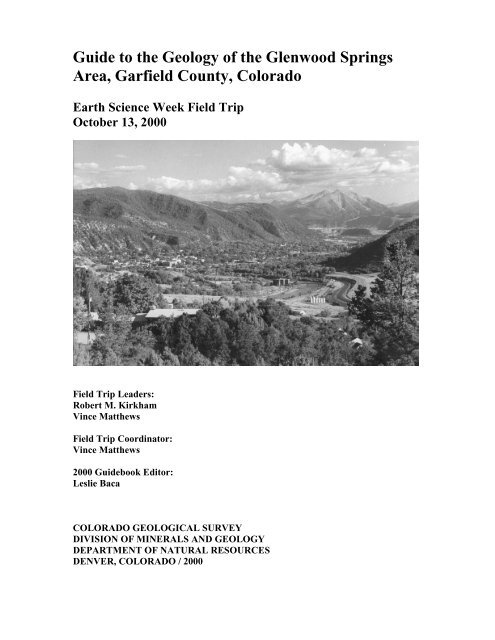
Guide to the Geology of the Glenwood Springs<br />
Area, Garfield County, <strong>Colorado</strong><br />
Earth Science Week Field Trip<br />
October 13, 2000<br />
Field Trip Leaders:<br />
Robert M. Kirkham<br />
Vince Matthews<br />
Field Trip Coordinator:<br />
Vince Matthews<br />
2000 Guidebook Editor:<br />
Leslie Baca<br />
COLORADO GEOLOGICAL SURVEY<br />
DIVISION OF MINERALS AND GEOLOGY<br />
DEPARTMENT OF NATURAL RESOURCES<br />
DENVER, COLORADO / 2000
Cover photo: Glenwood Springs, Lower Roaring Fork Valley, & Mount Sopris (by J.L. White)
Guide to the Geology of the Glenwood Springs Area,<br />
Garfield County, <strong>Colorado</strong><br />
Earth Science Week Field Trip<br />
October 13, 2000<br />
Field Trip Leaders:<br />
Robert M. Kirkham<br />
Vince Matthews<br />
Field Trip Coordinator:<br />
Vince Matthews<br />
2000 Guidebook Editor:<br />
Leslie Baca<br />
COLORADO GEOLOGICAL SURVEY<br />
Division of Minerals and Geology<br />
Department of Natural Resources<br />
1313 Sherman Street, Room 715<br />
Denver, <strong>Colorado</strong> 80203<br />
Phone: 303-866-2611<br />
Website: www.dnr.state.co.us/geosurvey<br />
1
CONTENTS<br />
Earth Science Week Field Trips................................................................................................... 1<br />
General Geology of the Glenwood Springs Area......................................................................... 1<br />
Geologic Time Scale for the Glenwood Springs Area................................................................. 3<br />
Rocks and Minerals...................................................................................................................... 4<br />
Descriptions of Rocks in the Glenwood Springs Area................................................................. 6<br />
Guide to the Route and Maps.....................................................................................................10<br />
Maps to the Route ...................................................................................................................... 17<br />
Stop Descriptions<br />
1. Glenwood Springs Mall ............................................................................................. 21<br />
2. Hanging Lake Rest Area ............................................................................................ 21<br />
3. No Name Fault ........................................................................................................... 25<br />
4. Canyon Creek/Storm King Mountain Overlook ........................................................ 26<br />
5. Lunch at Sayre Park ................................................................................................... 31<br />
6. Spring Valley.............................................................................................................. 31<br />
7. Sinkhole on <strong>Colorado</strong> Mountain College Campus..................................................... 33<br />
8. Mount Sopris/Piercement Diapir in Eagle Valley Evaporite ..................................... 34<br />
9. Coryell Ranch (County Road 109) Debris Flow........................................................ 35<br />
References .................................................................................................................................. 39<br />
2
EARTH SCIENCE WEEK FIELD TRIPS<br />
Earth Science Week began in 1997 when the Association of American State Geologists (AASG)<br />
passed a resolution declaring the second week of October as “Earth Science Week.” The<br />
American <strong>Geological</strong> Institute (AGI) is the national sponsor of Earth Science Week and is the<br />
lead organization coordinating national events. Many earth science-related organizations and<br />
government agencies, including the <strong>Colorado</strong> <strong>Geological</strong> <strong>Survey</strong>, celebrate Earth Science Week<br />
because it offers a tremendous opportunity for increasing earth science outreach and for<br />
improving science literacy.<br />
The AGI objective in establishing an annual, national Earth Science Week is to raise public<br />
understanding and awareness of the contributions the earth sciences make to our daily lives.<br />
This objective mirrors the mission of the <strong>Colorado</strong> <strong>Geological</strong> <strong>Survey</strong>—“to serve and inform the<br />
people of <strong>Colorado</strong> by providing sound geologic information and evaluation and to educate the<br />
public about the important role of earth sciences in everyday life in <strong>Colorado</strong>. ”<br />
To learn more about national Earth Science Week or to request an Earth Science Week<br />
information kit, visit the Earth Science Week web site, http://www.earthsciweek.org, or send<br />
your request to Earth Science Week, AGI, 4220 King St., Alexandria, VA 22302. To get on the<br />
mail list to receive information about future Earth Science Week field trips hosted by the<br />
<strong>Colorado</strong> <strong>Geological</strong> <strong>Survey</strong>, contact Vince Matthews at (303) 866-3028 or<br />
vince.matthews@state.co.us.<br />
During Earth Science Week 2000, geologists from the <strong>Colorado</strong> <strong>Geological</strong> <strong>Survey</strong> will lead a<br />
free public field trip in the Glenwood Springs area, as well as three others in various parts of the<br />
state. These trips are designed to acquaint participants with the geology, landscape, mineral<br />
resources, and geologic hazards of different parts of the state. Along the routes, participants will<br />
stop frequently to explore a special area, talk with geologists, or simply admire the views.<br />
People of all ages are welcome. The trips are especially useful to teachers of earth science<br />
classes.<br />
This free <strong>guide</strong>book explaining the geology, topography, and other features along the route will<br />
be given to each participant.<br />
GENERAL GEOLOGY OF THE GLENWOOD SPRINGS AREA<br />
The scenery and topography that you will see during this field trip have formed over billions of<br />
years through multiple episodes of mountain-building and uplift, widespread seas, swamps,<br />
down-cutting and erosion, dissolution, and collapse. The uplift of the White River Plateau to the<br />
north, folding of the Grand Hogback Monocline, deformation and subsidence of the Eagle Valley<br />
Evaporite, downcutting of the <strong>Colorado</strong> and Roaring Fork Rivers, Tertiary volcanism, and<br />
mineralized hot springs have produced the existing geologic environment in the Glenwood<br />
Springs area.<br />
Along the route, you will view the conspicuous structural feature, the Grand Hogback<br />
Monocline. The Grand Hogback Monocline forms the ridge of tilted bedrock to the west of the<br />
Roaring Fork River and to the south of the <strong>Colorado</strong> River valleys until the <strong>Colorado</strong> River<br />
1
passes through it at the town of Newcastle. This feature separates the vertically uplifted southern<br />
Rocky Mountains to the east from the flat-lying to gently folded <strong>Colorado</strong> Plateau to the west.<br />
Valley erosion, accelerated during the Pleistocene Ice Ages, and deposition of alluvium (waterborn<br />
deposits) and colluvium (gravity deposits) have developed much of the present day surface<br />
topography. Alluvial gravel terraces cover the eroded bedrock surfaces on the floors of the<br />
present day valleys. Along the edges of the valleys, colluvium and debris-fan deposits often<br />
overlie the terrace gravels.<br />
The town of Glenwood Springs is situated at the confluence of the <strong>Colorado</strong> and Roaring Fork<br />
rivers. Glenwood Springs has little elbow room in the narrow canyon of the <strong>Colorado</strong> River, and<br />
not much more in the lower valley of the Roaring Fork River. Various natural hazards related to<br />
the geologic environment effect human activity in the Glenwood Springs area. Expansion means<br />
building on steep canyon walls, not an easy matter and fraught with geologic risks. Debris flows<br />
and earthflows, in which slopes saturated with water break apart and move downhill, and rockfall<br />
have the potential of destroying or damaging buildings and endangering human life.<br />
These natural hazards occur in the dynamic geologic environment. In the context of human time<br />
(up to 100 years) the geologic environment appears to be fairly static. Over geologic time<br />
(thousands to millions of years), however, the geologic environment is continuously active and<br />
frequently interrupted by catastrophic events. Comprehending geologic time is difficult at best,<br />
but a sense of geologic time may be the most important concept you gain from this field trip and<br />
your other studies of geology. The slow rate of geologic processes, inch-by-inch over time, will<br />
have huge effects, if continued for enough years.<br />
You may already be familiar with many of the rock units and features in the Glenwood Springs<br />
area due to their economic value and use. For example, limestone has been quarried in this area<br />
from three principal locations, all of which are less than one mile from the city of Glenwood<br />
Springs. One of these limestone quarries retains an active permit status (1994) even though there<br />
has been not mining in recent years. Lead and zinc minerals with minor copper and silver have<br />
been identified near Windy Point (Strong Mine) on the north end of the Glenwood Spring<br />
quadrangle. In addition, there are thermal springs associated with the Leadville Limestone.<br />
Thermal springs or hot springs in the city of Glenwood Springs are characterized by their high<br />
salinity and flow rates (Barrett and Pearl, 1976); they provide economic value by their<br />
recreational and health benefits.<br />
Historically many towns in the Glenwood Springs area were founded on coal mining. The Mid-<br />
Continent Mine, between Redstone and Carbondale, closed in the early 1990s; reclamation<br />
projects are in progress. Although substantial reserves remain, there is no current coal mining in<br />
the Glenwood Springs area (J. Cappa, 1999, personal communication). Several thick beds of<br />
bituminous coal, which occur in the Mesa Verde Group of Late Cretaceous age, crop out in the<br />
area (Bass and Northrop, 1963).<br />
2
GEOLOGIC TIME SCALE FOR THE GLENWOOD SPRINGS AREA<br />
The purpose of this geologic time scale, which highlights the geologic events and corresponding<br />
rock units in the Glenwood Springs area, is to assist you in organizing your thoughts about the<br />
rocks and landforms you will see during this field trip.<br />
Era Period Epoch (millions of<br />
years ago)<br />
C<br />
E<br />
N<br />
O<br />
Z<br />
O<br />
I<br />
C<br />
(Age of<br />
Mammals)<br />
M<br />
E<br />
S<br />
O<br />
Z<br />
O<br />
I<br />
C<br />
(Age of<br />
Reptiles)<br />
P<br />
A<br />
L<br />
E<br />
O<br />
Z<br />
O<br />
I<br />
C<br />
(Age of<br />
Fishes)<br />
P<br />
R<br />
E<br />
C<br />
A<br />
M<br />
B<br />
R<br />
I<br />
A<br />
N<br />
Quaternary<br />
Tertiary<br />
Cretaceous<br />
Jurassic<br />
Triassic<br />
Permian<br />
Pennsylvanian<br />
Mississippian<br />
Devonian<br />
Silurian<br />
Ordovician<br />
Cambrian<br />
The<br />
Precambrian<br />
accounts for<br />
more than 85%<br />
of geologic<br />
time.<br />
Holocene<br />
Pleistocene<br />
Pliocene<br />
Miocene<br />
Oligocene<br />
Eocene<br />
Paleocene<br />
0.01<br />
1.6<br />
5.3<br />
23.7<br />
36.6<br />
57.8<br />
66.4<br />
144<br />
208<br />
245<br />
286<br />
320<br />
360<br />
408<br />
438<br />
505<br />
570<br />
3<br />
Geologic Events Rock Units<br />
Landslides, debris flows, rockfall<br />
Ice Age; accelerated downcutting of<br />
Glenwood Canyon<br />
Formation of Glenwood Canyon<br />
Basaltic volcanism & erosion; local &<br />
regional collapse by salt-tectonism<br />
(continues to present day)<br />
Erosion surface<br />
Formation of Grand Hogback<br />
Monocline & White River Uplift<br />
Beginning of Laramide Orogeny<br />
(continues into Eocene)<br />
Interior Seaway<br />
Swamp lands; dinosaurs roamed<br />
Erosion & submergence of Ancestral<br />
Rockies; minor tectonism<br />
Continued erosion of Ancestral Rockies<br />
Tectonism; uplift of Ancestral Rockies<br />
Widespread open sea with marine<br />
deposition<br />
Marine deposition<br />
Marine deposition followed by erosion<br />
Marine deposition with some mudflat<br />
deposits<br />
Marine deposition as the sea spread<br />
across denuded land<br />
A very long period of stability &<br />
erosion with mountains beveled to their<br />
roots;<br />
two or more periods of mountainbuilding,<br />
probably 1.5 & 2.5 billion<br />
years ago; rocks tightly folded, partly<br />
melted, & recrystallized, with granite<br />
intrusions<br />
alluvial, colluvial, glacial,<br />
eolian, & sinter deposits<br />
Conglomerate of Canyon<br />
Creek<br />
Basalt<br />
Wasatch Formation<br />
Mesaverde Group (coal)<br />
Mancos Shale<br />
Niobrara Formation<br />
Frontier Formation<br />
Mowry Shale<br />
Dakota Sandstone<br />
Morrison Formation<br />
Entrada Sandstone<br />
Chinle Formation<br />
State Bridge Formation<br />
Maroon Formation<br />
Eagle Valley Formation<br />
Eagle Valley Evaporite<br />
Belden Shale<br />
Leadville Limestone<br />
Chaffee Group<br />
UNCONFORMITY<br />
Manitou Formation<br />
Dotsero Formation<br />
Sawatch Quartzite<br />
NONCONFORMITY<br />
biotite granite,<br />
porphyroblastic biotite<br />
granodiorite, gneissic<br />
quartz monzonite, biotitemuscovite<br />
gneiss
ROCKS AND MINERALS<br />
Much of the chronology of geologic events that shaped the Glenwood Springs area is preserved<br />
in the rocks that remain today. On the other hand, the steady march of erosion has literally<br />
washed away rocks deposited over millions of years of geologic time, and, thereby, the<br />
information contained in them. Geologists call this “missing time” an unconformity. There are a<br />
number of unconformities to view along the route.<br />
In addition to the events that formed the Glenwood Springs area, this field trip will introduce<br />
participants to the rocks that make up the present landscape. All rocks can be grouped into three<br />
main classes depending on their origin:<br />
• Igneous Rocks (from the Latin ignis, “fire”) are literally “fire-formed rocks.” They result<br />
from hot, melted rock or magma deep within the earth. The magma may come to the surface<br />
of the earth as a volcanic or extrusive igneous rock or may cool slowly below the earth’s<br />
surface as intrusive igneous rock. Intrusive rocks are usually coarser-grained than their<br />
extrusive counterparts because slow cooling allows rock mineral crystals to grow larger.<br />
• Sedimentary rocks (from the Latin sedere, “to settle”) form from the accumulation of<br />
sediment—mineral crystals, particles of minerals and rocks, masses of organic matter, or<br />
chemical precipitates—that solidifies (lithifies) into layered rock. These broken or dissolved<br />
bits and pieces of other rock, loosened by frost, water, chemical breakdown, or gravity are<br />
carried by wind, water, or ice. They are generally deposited in layers and under pressure, and<br />
cementation by precipitating minerals, form into rock.<br />
• Metamorphic rocks (from the Greek meta, “change,” and morphe, “form”) result from the<br />
alteration of pre-existing rocks, either sedimentary or igneous, by heat, pressure, and<br />
chemically active fluids and gases. They may be altered only slightly or they may be<br />
changed so severely that it is difficult or impossible to figure out what they were originally.<br />
Some rocks, called migmatites, have almost completely remelted to become igneous rocks<br />
again.<br />
There are literally hundreds of kinds of rocks recognized by geologists. For use during this field<br />
trip, it is suggested that you refer to Table 1 for some common rock types in the Glenwood<br />
Springs area.<br />
Rocks are made of minerals—homogenous, naturally-occurring, inorganic solid substances with<br />
definite chemical compositions and characteristic internal structures and physical properties. A<br />
few common minerals that form the rocks in the Glenwood Springs area are listed alphabetically<br />
below.<br />
• Anhydrite—white, grayish, bluish, reddish, pale lavender rock-forming mineral in evaporite<br />
deposits, which form by the evaporation of brines. Anhydrite consists of calcium and sulfate.<br />
4
• Calcite—a white to light-gray mineral (may be colored by impurities) composed of calcium<br />
and carbonate. It can’t be scratched with a fingernail but can with a knife. When dilute<br />
hydrochloric acid is applied, it fizzes! Calcite is the most common mineral found in<br />
limestone.<br />
• Chert—a type of quartz made of silica (SiO2). Chert is usually light-colored, although it<br />
may be many other colors depending on trace minerals, e.g., a type of chert is jasper which is<br />
red. Chert is dense, harder than a knife, and exhibits shell-like fracture.<br />
• Dolomite—glassy to pearly luster; color variable, often pink; harder than a penny; bubbles<br />
slowly in dilute hydrochloric acid. The term dolomite is used by some geologists for a rock<br />
as well as a mineral.<br />
• Feldspar—a translucent pinkish, grayish, or whitish mineral very common in granite,<br />
recognized by its tendency to break along flat cleavage faces that catch the sunlight.<br />
Feldspar also has a “stringy” appearance when inspected closely. There are several different<br />
types of feldspars, distinguished by their chemical composition.<br />
• Gypsum—a soft (scratch it with a fingernail) transparent or translucent colorless mineral<br />
formed as an evaporite where sea water or salty ponds dry up.<br />
• Halite—colorless to white, other colors if impure; glassy luster; about as hard as a fingernail;<br />
occurs as cubic crystals of sodium chloride. Most table salt comes from halite.<br />
• Hornblende—a black mineral in rod-like crystals (as distinct from flat mica crystals)<br />
common in dark igneous and metamorphic rocks.<br />
• Mica—a soft (scratch it with your fingernail) black, green, or silvery mineral that can be<br />
separated easily along shiny flat paper-thin cleavage faces; very common in granite and<br />
schist. Black mica is biotite; white mica is muscovite.<br />
• Quartz—a clear, hard (can’t be scratched with a knife), shiny, glassy mineral that is the<br />
primary mineral in most sandstone and one of the primary minerals in granite. Quartz in<br />
rocks is commonly clear and colorless, but it may be pink (rose quartz), lavender (amethyst),<br />
snow white (milky quartz), or gray and clear (smoky quartz).<br />
5
Table 1: Some Common Rock Types in the Glenwood Springs Area<br />
Class Rock Description<br />
Sedimentary<br />
Igneous<br />
Extrusive<br />
Igneous<br />
Intrusive<br />
Metamorphic<br />
Sandstone<br />
Mudstone<br />
Siltstone<br />
Claystone<br />
Shale<br />
Conglomerate<br />
Limestone<br />
Basalt<br />
Pyroclastics<br />
Granite<br />
Monzonite<br />
Granodiorite<br />
Quartzite<br />
Gneiss<br />
Schist<br />
Rocks that consists of lithified sand.<br />
Lithified mud that breaks into blocks. If it is fissile, it is shale.<br />
Lithified silt.<br />
Lithified clay. It will stick to your tongue if chewed.<br />
Grains of silt and clay cemented together, usually breaking into thin<br />
sheets or plates parallel to the layering or bedding.<br />
Pebbles, cobbles, boulders, and sand deposited as gravel and then<br />
cemented together.<br />
Composed mostly of calcite, deposited as a limy mud. Usually<br />
white or gray, often containing fossils<br />
Very fine-grained gray to black volcanic rock, often with gas<br />
bubbles<br />
Rock materials that have been violently (or abruptly) ejected from a<br />
volcanic vent<br />
Common light-colored coarse-grained rock with visible crystals of<br />
quartz, feldspar, and mica.<br />
Granite-like rock. Generally somewhat darker than granite.<br />
Difficult to differentiate from granite “in the field.” Usually vary<br />
from granite in the amount and kind of feldspar present.<br />
Sandstone so tightly cemented that it breaks through the individual<br />
sand grains.<br />
Has the composition of granite but has light and dark bands that are<br />
often folded or contorted.<br />
Medium- to coarse-grained foliated rock in which the mineral<br />
grains, in particular mica crystals, are lined up and highly visible.<br />
Schist tends to split along parallel planes.<br />
DESCRIPTION OF ROCKS IN THE GLENWOOD SPRINGS AREA<br />
The following brief descriptions of the rocks in the Glenwood Springs area correspond to the<br />
geologic time scale shown previously. More detailed descriptions may be found in the Geologic<br />
Map of the Glenwood Springs Quadrangle, Garfield County, <strong>Colorado</strong> by R.M. Kirkham, R.K.<br />
Streufert, and J.A. Cappa (<strong>Colorado</strong> <strong>Geological</strong> <strong>Survey</strong> Map Series 31).<br />
Holocene and Pleistocene<br />
• Recent—very young deposits, mostly loose soil.<br />
• Alluvial deposits—silt, sand, and gravel deposited in stream channels, flood plains, glacial<br />
outwash terraces, debris fans, and sheetwash areas along the <strong>Colorado</strong> River, Roaring Fork<br />
River, and their tributaries.<br />
• Colluvial deposits—silt, sand, rocks of various sizes, and clay on valley sides, valley floors,<br />
and hillslopes that were transported and deposited primarily by gravity, but frequently<br />
assisted by sheetwash erosion, freeze-thaw action, and water-saturated conditions.<br />
• Glacial deposits—boulders, gravel, sand, silt, and clay deposited by ice in moraines.<br />
• Eolian deposits—silt, sand, and clay deposited by wind.<br />
• Sinter deposits—chemical sediment deposited by mineral springs.<br />
6
Miocene<br />
Sedimentary Rock<br />
• Conglomerate of Canyon Creek—cobble conglomerate and a few local sandstone beds<br />
(Thickness: approximately 1,180 ft).<br />
Igneous Rock<br />
• Basalt—basalt, olivine basalt, and andesitic basalt flows, and interbedded siltstone,<br />
conglomerate, sandstone, and claystone. Over a dozen flows form the caprock for the Flat<br />
Tops or can be seen on south flank of the Basalt Mountain shield volcano (Thickness:<br />
approximately 250 ft).<br />
Paleocene and Eocene<br />
Sedimentary Rock<br />
• Wasatch Formation—reddish-brown, reddish-purple, yellowish-brown, tan, and white<br />
sandstone, siltstone, conglomeratic sandstone, conglomerate, mudstone, and claystone<br />
(Thickness: approximately 5,000 ft).<br />
Upper Cretaceous<br />
Sedimentary Rock<br />
• Mesaverde Group—yellowish-gray fine-grained sandstone, yellowish-brown and olive-gray<br />
carbonaceous mudstone and shale, and coal (Thickness: approximately 4,700 ft).<br />
• Undivided—Mancos Shale—light-to-dark-gray, locally bentonitic, carbonaceous shale<br />
about 4,200 ft that contains fish scales; Niobrara Formation—gray, white-weathering,<br />
calcareous shale and shaley limestone; limestone beds in lower part about 330 ft; Frontier<br />
Formation—yellow-brown calcareous shale and sandstone unit about 300 ft thick; Mowry<br />
Shale—dark gray shale about 50 to 70 ft thick that contains fish scales.<br />
Lower Cretaceous<br />
Sedimentary Rock<br />
• Dakota Sandstone—yellowish-brown, medium-to-coarse-grained, massive to cross-bedded<br />
sandstone containing lenses of chert-pebble conglomerate and beds of dark-gray to black<br />
carbonaceous sandy siltstone and mudstone (Thickness: approximately 90 to 175 ft).<br />
Upper Jurassic<br />
Sedimentary Rock<br />
• Morrison Formation—medium-to-light-green and grayish-red mudstone and shale and dark<br />
gray limestone; beds of silty sandstone near base (Thickness: averages 400 to 500 ft). This<br />
formation is famous for its dinosaur fossils and tracks.<br />
Middle Jurassic<br />
Sedimentary Rock<br />
• Entrada Sandstone—light gray to light orange, medium-to-very-fine-grained, crossbedded<br />
sandstone. The Entrada Sandstone forms a prominent light-gray ledge at nearly all exposures<br />
and is particularly conspicuous because of its position above the red rocks of the Chinle<br />
Formation (Thickness: approximately 50 to 100 ft).<br />
7
Upper Triassic<br />
Sedimentary Rock<br />
• Chinle Formation—dark-reddish-brown, orangish-red, and purplish-red calcareous<br />
siltstone, light-purplish-red and gray limestone and limestone-pebble conglomerate<br />
(Thickness: approximately 225 ft).<br />
Lower Triassic? and Permian<br />
Sedimentary Rock<br />
• State Bridge Formation—pale-red, grayish-red, reddish-brown, and greenish-gray micaeous<br />
siltstone, clayey siltstone, shale, and minor sandstone. The South Canyon Creek Member<br />
includes a four-ft-thick, greenish-gray to light-olive-gray dolomite and a 1.6 ft-thick, light- to<br />
dark-gray limestone (color dependant on amount of solid hydrocarbon) with prominent wavy<br />
or crinkled laminae (Thickness: approximately 160 ft).<br />
Permian and Pennsylvanian<br />
Sedimentary Rock<br />
• Maroon Formation—mainly red beds of sandstone, conglomerate, mudstone, siltstone, and<br />
claystone with minor, thin beds of gray limestone. The Maroon Formation is the prominent<br />
red sandstone seen throughout the Glenwood Springs area. At the top of the Maroon<br />
Formation is the Schoolhouse Member—light-gray to greenish-black, grayish-red, and palereddish-brown,<br />
fine-grained, feldspathic sandstone and conglomeratic sandstone which<br />
contains locally abundant interstitial and grain coatings of old hydrocarbon (Total thickness<br />
about 3,000 to 4,000 ft, including the 150- to 175-ft-thick Schoolhouse Member).<br />
Middle Pennsylvanian<br />
Sedimentary Rock<br />
• Eagle Valley Formation—reddish-brown, gray, reddish-gray, and tan siltstone, shale,<br />
sandstone, gypsum, limestone, and dolomite (Thickness: approximately 500 to 1,000 ft).<br />
• Eagle Valley Evaporite—gypsum, anhydrite, halite, and gray partly gypsiferous siltstone<br />
and shale, sandstone, limestone, and dolomite (Thickness: approximately 1,200 - 9,000 ft).<br />
Lower Pennsylvanian<br />
Sedimentary Rock<br />
• Belden Formation—medium-gray to black and dark-brown calcareous shale and gray<br />
fossiliferous limestone (Thickness: approximately 660 - 820 ft).<br />
Mississippian<br />
Sedimentary Rock<br />
• Leadville Limestone—gray to bluish-gray, coarse- to fine-grained, fossiliferous limestone<br />
and dolomite. Contains oolites, calcareous algae, fish teeth, and brachiopods (Thickness:<br />
approximately 200 ft).<br />
8
Upper Devonian<br />
Sedimentary and Metamorphic Rocks<br />
• Chaffee Group—sequence composed of green shale, quartzite, dolomite, limestone, and<br />
dolomitic sandstone. It consists of the following formations—from top to bottom: Gilman<br />
Sandstone, Dyer Dolomite, and Parting Formation.<br />
Lower Ordovician<br />
Sedimentary Rocks<br />
• Manitou Formation—consists predominantly of medium-bedded brown dolomite at the top<br />
with thin beds of gray flat-pebble limestone interbedded with greenish-gray calcareous shale,<br />
sandstone, and brown-weathering limestone and dolomite in the lower portions. Includes the<br />
Tie Gulch and Dead Horse Conglomerate Members (Thickness: approximately 150 - 170 ft).<br />
Upper Cambrian<br />
Sedimentary Rocks<br />
• Dotsero Formation—thinly-bedded, tan to gray, silty and sandy dolomite, dolomitic<br />
sandstone, green dolomitic shale, limestone and dolomite conglomerate, limestone, and<br />
pinkish-light-gray to very light-gray and white to lavender weathering algal limestone.<br />
Includes the Clinetop and Glenwood Canyon Members (Thickness: approximately 100 ft).<br />
• Sawatch Quartzite—white and buff to gray-orange, brown-weathering vitreous<br />
metamorphosed quartz sandstone in beds from 1- to 3-ft-thick. Locally the Sawatch<br />
Quartzite contains beds of arkosic (i.e., 25% or more feldspar) quartz-pebble conglomerate at<br />
the base of the unit which rest unconformably on highly weathered Precambrian rocks<br />
(Thickness: approximately 540 ft).<br />
Note: A major unconformity, called a nonconformity, lies between the Precambrian<br />
metamorphic and igneous rocks and the Late Cambrian sedimentary rocks. There is about a<br />
billion years of time missing at this unconformity.<br />
Precambrian<br />
Metamorphic and igneous rocks<br />
• biotite granite—dark-gray and white-speckled, fine- to coarse-grained, equigranular granite<br />
and granodiorite.<br />
• porphyroblastic biotite granodiorite—coarse-grained, inequigranular with large, pink<br />
crystals of feldspar. Porphyroblastic biotite granodiorite is found at the No Name Tunnel.<br />
• gneissic quartz monzonite—fine-to medium-grained, equigranular, foliated, quartz<br />
monzonite.<br />
• biotite-muscovite gneiss—well to poorly foliated biotite-muscovite gneiss.<br />
9
GUIDE TO THE ROUTE<br />
We’ll start the trip at the Glenwood Springs Mall, 51027 Hwy 6 and 24. The mall is located off<br />
Interstate 70 at the West Glenwood Exit 114. We’ll form in carpools and travel as a caravan.<br />
You must travel in the caravan. Please drive with your headlights on while in the caravan.<br />
Drive safely but stay as close as you can to the car in front of you. Please obey all traffic signs.<br />
When we stop, park as close as possible to the car in front of you and turn off your lights.<br />
Private Property. Some stops on the field trip are on private property. The owners have given<br />
us permission to visit on the day of the field trip only. Please conduct yourselves as guests and<br />
obey all instructions from the trip leaders, so that we may be welcome to return on future field<br />
trips.<br />
Please follow these simple rules of courtesy at the field trip stops:<br />
• Do not litter the area. (This includes cigarette butts.)<br />
• Do not climb on fences.<br />
• Leave all gates as you found them.<br />
• Treat public property as if you were the owner—which you are!<br />
When using this booklet for another field trip with your students, a youth group, friends or<br />
family, remember that you must get permission from property owners or their agents before<br />
entering private property. No trespassing please.<br />
Four topographic 7.5-minute quadrangle maps by the USGS: Glenwood Springs, Shoshone,<br />
Cattle Creek, and Storm King Mountain, provide coverage of this field trip area.<br />
Miles Miles<br />
from last from<br />
point start<br />
STOP 1 Glenwood Springs Mall<br />
0.0 0.0 Leave Stop 1. Exit parking lot of Glenwood Springs<br />
Mall, heading south to I-70 via Exit 114.<br />
0.3 0.3 Enter I-70 eastbound.<br />
3.4 3.7 No Name Tunnel<br />
0.9 4.6 No Name Exit (119)<br />
This tunnel passes through a unique igneous rock with<br />
large crystals called porphyroblastic biotite granodiorite.<br />
Samples may be collected along the bike path from<br />
Glenwood Springs.<br />
10
2.3 6.9 Grizzly Creek Rest Area Exit (121)<br />
The Grizzly Creek Rest Area is located at the confluence of<br />
Grizzly Creek and <strong>Colorado</strong> River. The remote but<br />
spectacular Grizzly Creek Canyon branches to the north<br />
from Glenwood Canyon. Grizzly Creek Canyon cuts into<br />
the depths of the White River Uplift. The Paleozoic rock<br />
strata that can be seen from the highway, well up on<br />
Grizzly Canyon, are near the area of maximum uplift<br />
and are much higher in elevation than the same rock<br />
formations seen along most of Glenwood Canyon.<br />
Upper Grizzly Creek Canyon was glaciated during the<br />
Pleistocene.<br />
1.5 8.4 View across of nonconformity between Precambrian<br />
metamorphic and igneous rocks and Late Cambrian<br />
sedimentary rocks.<br />
2.9 11.3 Leave I-70 at Hanging Lake Rest Area Exit.<br />
0.4 11.7 Hanging Lake Rest Area<br />
STOP 2 Hanging Lake Rest Area (See stop description.)<br />
0.0 11.7 Leave Stop 2. Return to westbound I-70 on-ramp.<br />
Pause to look at the ancient rockslides across the <strong>Colorado</strong><br />
River. These rockslides dammed the <strong>Colorado</strong> River 9,900<br />
years ago and created Cottonwood Rapids. An active rock<br />
chute empties at the westbound lanes of I-70. An impact<br />
barrier wall and hundreds of rockbolts can be seen in the<br />
high rock cut to the right in order to mitigate these<br />
rockslides.<br />
1.9 13.6 Across the <strong>Colorado</strong> River are two large rockslides that<br />
partially blocked the <strong>Colorado</strong> River. The railroad<br />
cuts through steep debris cones created by rockslides.<br />
2.3 15.9 Grizzly Creek Exit<br />
1.6 17.5 Rockfall Fence at milepost 120.2<br />
This rockfall fence was constructed in an active rockfall<br />
chute. Fresh scarring can be seen high in the benchy cliffs<br />
above. The fence was manufactured by Brugg Cable<br />
11
Products. Look closely at the fence material and you can<br />
see that the mesh is fabricated by woven interlocked cable<br />
loops, much like the Olympic symbol. This fence has a<br />
design impact load of 369 tons. The final cost of the<br />
fence approached $800 per linear foot.<br />
1.5 19.0 No Name Exit and Rest Area<br />
The village of No Name and the No Name Rest Area lies<br />
on a large late Pleistocene fan at the mouth of No Name<br />
Creek. This fan overlies Pinedale terrace alluvium<br />
(Pinedale refers to the Pinedale glaciation, the last major<br />
ice age, which occurred 12,000-35,000 years ago). Note<br />
how the <strong>Colorado</strong> River flows around the fan.<br />
Brush-covered slope across the river southeast of the<br />
exposed cliffs of Paleozoic rock is mantled with landslide<br />
and debris-flow deposits.<br />
Rock used in the construction of the rest area is entirely<br />
Sawatch Quartzite.<br />
0.3 19.3 Park on the right shoulder of I-70 at a pull-out near the<br />
tunnel.<br />
STOP 3 No Name Fault (See stop description.)<br />
0.0 19.3 Leave Stop 3. Continue westbound on I-70.<br />
1.2 20.5 View of cave-like features in Leadville Limestone across<br />
river.<br />
Ground water accomplishes geologic work—as do surface<br />
water, glacial ice, and wind—by erosion and deposition. It<br />
erodes mainly by dissolving rocks, in this case carbonate<br />
rock, i.e., limestone. This type of erosional topography is<br />
called karst. One type of karst landform is a cave—roofed<br />
over, underground cavity dissolved by “carbonated” water,<br />
i.e., carbonic acid (water + carbon dioxide from air and<br />
soil). These caves were formed along fractures (joints) in<br />
the limestone that enlarged as groundwater flowed through<br />
the cracks and dissolved the limestone. The caves in the<br />
Leadville Limestone, along with hot mineral waters are<br />
used at the Yampa Springs Spa.<br />
12
5.6 26.1 South Canyon Exit Overpass<br />
View of Cretaceous to Pennsylvanian/Permian stratigraphic<br />
section<br />
2.4 28.5 Leave I-70 at Canyon Creek Exit (109).<br />
View of Storm King Mountain and tilted beds of the Grand<br />
Hogback Monocline<br />
STOP 4 Canyon Creek/Storm King Mountain View Point (See stop description.)<br />
0.0 28.5 Leave Stop 4. Return to I-70 but head east, returning to<br />
Glenwood Springs.<br />
6.5 35.0 View of terrace scarps in West Glenwood Springs<br />
A terrace is composed of river-deposited gravel and sand.<br />
Several terrace levels may occur, each representing a<br />
period of stabilized but heavy river flow. These alluvial<br />
terraces can be correlated with other terraces nearer to the<br />
mountains, and those in turn can sometimes be traced fairly<br />
continuously along major streams into the high mountains,<br />
where each terrace seems to end at a moraine left by an<br />
ancient glacier. We can be fairly sure that terrace<br />
formation coincides with periods of cooler climate, i.e.,<br />
during the Pleistocene Ice Age, when there were glaciers in<br />
mountain valleys, and torrential streams, loaded heavily<br />
with sediment from the glaciers, often reached flood stage<br />
(Chronic, 1980).<br />
1.0 36.0 Leave I-70 at Exit 116. Turn left (north) at the bottom of<br />
the exit ramp. Turn right (east) onto 6 th St. (US Hwy 6 and<br />
40). Turn right (south) on Grand Ave.<br />
0.3 36.3 Cross river.<br />
0.9 37.2 Sayre Park<br />
View of Hot Springs Pool<br />
13
STOP 5 LUNCH at Sayre Park (Hyland Park Drive) (See stop description.)<br />
Note: The route to Stop 6 will follow Red Canyon Road, a narrow shelf road with steep dropoffs<br />
and no guard rails. Anyone that prefers not to use this road may leave lunch early and use<br />
an alternate route to Stop 6.<br />
Alternate Route: Continue south on Hwy 82 for about 3 miles to CR 114 (road to <strong>Colorado</strong><br />
Mountain College). Continue on CR 114 past the college and the junction of CR 114 and CR<br />
115. At the junction, continue on CR 115. Stop 6 is at the north end of Spring Valley behind the<br />
mailboxes. If you get separated from the caravan, you can also meet us at Stop 7 (<strong>Colorado</strong><br />
Mountain College).<br />
0.0 37.2 Leave Stop 5. Return to Grand Ave./Hwy 82.<br />
2.9 40.1 Turn left (east) onto Red Canyon Road (CR 115).<br />
Drive up Red Canyon to the north end of Spring Valley.<br />
2.7 42.8 Pull off to the left of the road behind the mail boxes (Spring<br />
Valley turn-around).<br />
STOP 6 Spring Valley (See stop description.)<br />
0.0 42.8 Leave Stop 6. Continue (southwest) on CR 115 (Red<br />
Canyon Road). Veer right onto CR 114 at the junction of<br />
CR 114 and CR 115.<br />
4.9 46.8 Turn left at the <strong>Colorado</strong> Mountain College Campus.<br />
Drive an additional 0.3 miles and park in the dirt parking<br />
lot next to the soccer field.<br />
.3 47.1 Walk 200 ft to rock tower ruin and view large<br />
sinkhole in basalt.<br />
STOP 7 Sinkhole on <strong>Colorado</strong> Mountain College Campus (See stop description.)<br />
0.0 47.1 Leave Stop 7. Turn left (southwest) as you leave CMC,<br />
returning to CR 114.<br />
1.4 48.5 View of Roaring Fork Valley and Mount Sopris<br />
1.8 50.3 Turn left (south) on Hwy 82.<br />
3.1 53.4 Turn left (east) on Aspen Glen frontage road, which is<br />
adjacent to Hwy 82. Continue on the frontage road; you<br />
will begin to head north.<br />
14
0.3 53.7 Pull off to the right side of the frontage road.<br />
STOP 8 Mt. Sopris/Piercement Diapir in Eagle Valley Evaporite (See stop description.)<br />
0.0 53.7 Leave Stop 8. Continue north on frontage road then<br />
circle to the south.<br />
0.3 54.0 Return to Hwy 82 heading southbound.<br />
1.8 55.8 Mt. Sopris Overlook and views of sinkholes at Coryell<br />
Ranch across the Roaring Fork River<br />
0.8 56.6 Turn right (south) onto Hwy 133 heading toward<br />
Carbondale.<br />
1.0 57.6 Turn right at the 7-11 Store (CR 106). Turn left on CR 108<br />
and continue briefly.<br />
0.9 58.6 Turn right (north) onto CR 109.<br />
0.8 59.3 Coryell Ranch debris flow<br />
STOP 9 Coryell Ranch (County Road 109) Debris Flow (See stop description.)<br />
0.0 59.3 Leave Stop 9. Continue northbound on CR 109.<br />
1.5 60.8 Sinkhole/ground fissures on left (south)<br />
This site is a good example of evaporitic karst<br />
topography and geology. Deep ground fissures have<br />
opened into the bedrock and exceed 50 feet in depth.<br />
This evaportive karst developed thousands of years ago.<br />
Re-cemented gypsiferious breccia is found near the current<br />
fissure. This karst area may have been reactivated by the<br />
Kaiser Sievers irrigation ditch. That irrigation ditch has<br />
been lined through this area because of water loss into the<br />
bedrock voids. That liner is now leaking and new<br />
sinkholes in the backfill have opened.<br />
Massive gypsum bedrock samples, called alabaster, can be<br />
collected from here.<br />
Solutioning of gypsum in the Eagle Valley Evaporite are<br />
probably associated with irrigation ditch seepage.<br />
Numerous sinkholes are located on Middle Pleistocene<br />
15
1.8 to 2.5 45.5 to 46.2 Road distress on CR 109<br />
(Bull Lake) river terrace up slope to the southwest. This<br />
site is along the trend of the Cattle Creek anticline.<br />
Many sections of this road dip, roll, and sag where<br />
settlement and collapse of the native soil has occurred.<br />
This road passes through a number of known and suspect<br />
hydrocompactive soil locations. Where uncontrolled waters<br />
flow or collect, such as near the Teller Springs<br />
Development, Garfield County Road Department has had<br />
to repair the road.<br />
0.9 66.0 View of tilted terrace from Rose Ranch<br />
River terraces, only tens of thousands of years old, that<br />
would normally slope slightly toward the river tilt away<br />
from the river. The upward flow of evaporites along the<br />
rivers have caused the tilting of the younger rocks and<br />
river terraces.<br />
1.2 67.2 Turn left (north) onto Hwy 82.<br />
3.3 70.5 Turn left (west) onto 27 th Street from Hwy 82. Continue<br />
southwest on S. Grand Ave.<br />
0.3 70.8 Turn right (north) onto Midland Ave.<br />
View of the White RiverUplift to the north of Glenwood<br />
Springs<br />
2.2 73.0 Cross the distal edge of the red debris fan on the left.<br />
Debris fans are fan-shaped bodies at the base of steep<br />
slopes. Sediment is carried by water during storm events<br />
and deposited in fans where streams run out onto a level<br />
plain. Debris flows occur rather frequently on the fans<br />
located along the sides of the Roaring Fork and <strong>Colorado</strong><br />
River Valleys. The source areas are basins within the<br />
Eagle Valley Formation, Eagle Valley Evaporite, and the<br />
Maroon Formation. Debris flows are a widespread<br />
geologic hazard that impacts Glenwood Springs since most<br />
of the town lies on fans.<br />
1.8 55.9 Continue on Midland Ave. and return to Glenwood Springs<br />
Mall parking lot.<br />
16
4<br />
Field Trip Map No. 1<br />
Canyon Creek/<br />
Storm King Mtn View Point<br />
0 .5 1.0 2.0 3.0 Mi<br />
70<br />
0 .5 1.0 2.0 3.0 4.0 5.0 Km<br />
Base from USGS<br />
Contour Interval = 80 feet<br />
South<br />
Canyon<br />
Storm King<br />
Mountain<br />
N<br />
1<br />
Glenwood Springs Mall<br />
6<br />
82<br />
5<br />
Midland Ave<br />
70<br />
Glenwood<br />
Springs<br />
Sayre<br />
Park
82<br />
5<br />
70<br />
Sayre Park<br />
Field Trip Map No. 2<br />
No Name Fault<br />
3<br />
No Name<br />
Glenwood Springs<br />
Grizzly Cr<br />
70<br />
Hanging Lake<br />
Rest Area<br />
Shoshone<br />
Dam<br />
2<br />
Hanging<br />
Lake
Field Trip Map No. 3<br />
Midland Ave<br />
6<br />
82<br />
Spring Valley<br />
Cattle Creek<br />
8<br />
7<br />
Sinkhole<br />
Piercement Diapir
9<br />
Coryell Ranch<br />
Debris Flow<br />
Cattle Creek<br />
15<br />
Field Trip Map No. 4<br />
8<br />
Midland Ave<br />
82
STOP DESCRIPTIONS<br />
STOP 1 Glenwood Springs Mall<br />
Topic: Overview of trip and route<br />
• Introductions<br />
• The day-long trip begins at 7:45 a.m. and ends about 5:00 p.m.<br />
• To enter private property, you must sign a liability waiver on the morning of the trip.<br />
• Trips will be held rain or shine. Wear comfortable clothing and walking shoes. Bring extra<br />
warm clothing and rain gear.<br />
• Bring a packed lunch, snacks, and drinks.<br />
• Arrange for your own transportation. Participants will carpool from the starting point and<br />
travel in a caravan. Bring a full tank of gas.<br />
STOP 2 Hanging Lake Rest Area<br />
Topics: 1) History of Glenwood Canyon<br />
2) Unconformity (i.e., nonconformity) between Precambrian<br />
and Upper Cambrian Rocks<br />
3) Holocene Rockfall at the Shoshone I-70 Interchange<br />
4) Construction of I-70 and Geologic Hazards in Glenwood<br />
Canyon<br />
History of Glenwood Canyon<br />
Glenwood Canyon was formed by the <strong>Colorado</strong> River as it eroded into the southern flank of the<br />
White River Uplift. During the Pleistocene Ice Ages, rates of downcutting were accelerated due<br />
to glacial melting that caused heavily, over-loaded streams often at flood levels. Regional uplift<br />
also encouraged rivers to cut deep canyons. Most of the steep inner walls of Glenwood Canyon<br />
have been carved during the past 3 million years.<br />
Thousands of vertical feet of downcutting have developed magnificent exposures of the Early to<br />
Middle Paleozoic formations of central <strong>Colorado</strong> and, most visually pronounced, the<br />
nonconformity of the 500-foot-thick cliffs of Cambrian Sawatch Quartzite overlying<br />
Precambrian metamorphic and granitic basement rock. Realize that although rock sequences<br />
record time, they don’t preserve a complete record of time. Although time is continuous, the<br />
rock record has not been. A nonconformity, like the one seen at Hanging Lake Rest Area, is a<br />
gap or discontinuity in the rock record. A nonconformity is one of three types of unconformities.<br />
In a nonconformity, eroded igneous or metamorphic rocks are buried by sedimentary rocks. The<br />
type of unconformity easiest to visualize is the angular unconformity; in this type, the rocks<br />
beneath the unconformity are tilted at an angle. The most difficult type to recognize is the<br />
disconformity, which separates parallel strata; this type is often identified by differences in<br />
fossils in the layers above and below the unconformity (Cvancara, 1995). There are numerous<br />
gaps in the rock record in the Glenwood Springs area. The nonconformity seen at Hanging Lake<br />
Rest Area is the primary one we will see along the route today. About one billion years of<br />
geologic time is missing from the rock record at this nonconformity.<br />
21
Prior to preliminary geologic investigations for the Glenwood Canyon Interstate 70 Project, it<br />
was expected that the surficial deposits in Glenwood Canyon were a thin bed load of river gravel<br />
overlying bedrock, with a veneer of rockfall deposits on the canyon sides. It became apparent,<br />
however, that thick deposits of interfingering and mixed alluvial, colluvial, and lake sediments<br />
had aggraded in the canyon. Most startling was that the entire eastern half of the canyon<br />
contained a deposit of clay, silt, and fine sand that ranged from 30 to 60 feet thick. This deposit,<br />
known during construction of Glenwood Canyon, as the notorious “Gray Layer” is underlain by<br />
river alluvium with mixed colluvial rocks, and overlain by roughly 30 feet of colluvial rocks in<br />
alluvial fines. These deposits are increasingly complex as interfingering and lateral mixing<br />
occurs at slope edges, where talus and debris flows are incorporated, and at the mouths of<br />
tributary streams (e.g., French Creek, Tie Gulch, Dead Horse Creek, and Cinnamon Creek).<br />
Early in investigations, it was unclear what caused the deposition of the clay and silt sediments.<br />
Speculation arose as to whether rockfall, debris flooding, glacial activity, or perhaps even fault<br />
movement had occurred.<br />
A more informed picture of the Late Pleistocene history of the canyon emerged with increased<br />
subsurface investigations. During the Holocene Epoch, from about 12,000 years ago to the<br />
present, the canyon has become choked with colluvial, alluvial, and lacustrine (lake) deposits.<br />
As the Pleistocene Ice Ages ended, river flow rates likely decreased. Lower water levels<br />
affected the ability of the river to transport material from the canyon and resulted in an aggrading<br />
environment. The Holocene history within the canyon is marked by deposition rates that<br />
exceeded the ability of the river to transport sediment out of the canyon.<br />
A major contribution to the aggradation of the canyon floor was a rock slide that occurred near<br />
the Hanging Lake Rest Area in a narrow portion of the canyon (Figure 1). Investigative borings<br />
indicated that many areas within the canyon have Holocene sediments over 200 feet thick.<br />
Borings also revealed that a massive rockslide completely dammed the river, formed a lake,<br />
thereby creating lacustrine deposits of soft compressible silts and clays 60 feet in thickness,<br />
referred to earlier as the Gray Layer. On the canyon walls mass wasting of the steep cliffs<br />
created thick aprons of talus (rockfall deposits) that interfingered with earlier and later rising<br />
alluvial deposits.<br />
These Holocene boulder talus fields are full of voids and readily shift and settle. The lakederived<br />
lacustrine silts and clays are soft and will not support highway structures. Both colluvial<br />
and lacustrine depositional environments required costly and innovative deep foundation design<br />
for bridge piers, abutments, and retaining walls, and also staged construction to allow the<br />
consolidation of compressible sediments.<br />
Holocene Rockfall at Shoshone I-70 Interchange<br />
Figure 1 shows the location of the huge rockslide that filled the canyon floor, dammed the river,<br />
and created the Cottonwood Falls seen today.<br />
The natural dam was not so much breached but was filled in with sediment and overtopped. The<br />
river flows over this knickpoint and creates the rapids seen today. This rock slide was dated as<br />
occurring at 9,820 ± 130 years before present using Carbon-14 dating done in December 1981.<br />
22
Organic material at the base of the Gray Layer retrieved by exploratory drilling were dated.<br />
Atop the Gray Layer is a 20 to 40 foot armored layer of rockfall debris that has fallen or slid onto<br />
the canyon floor afterwards.<br />
The Gray Layer indicates that during Holocene time a lake existed within this part of Glenwood<br />
Canyon into which fine sediment was deposited. This fine, lacustrine sediment composes the<br />
Gray Layer. The Gray Layer extends through the canyon to somewhere around Dotsero; the<br />
precise upvalley extent is not known. The Gray Layer is predominately dark gray to gray-black<br />
in color. Commonly within the deposits are reddish-brown bands and laminae. Presumably,<br />
these red layers were the result of fine-grained sediment settling from single storm events. The<br />
storms occurred up-river in the McCoy, Bond, State Bridge area where red mudflows from steep,<br />
rugged tributaries within the Maroon Formation redbeds enter the <strong>Colorado</strong> River. On several<br />
occasions during the construction of I-70 through Glenwood Canyon, the river was observed<br />
turning a chocolate-red color as it become hyperconcentrated with clay and silt. The river<br />
sediment load at these times gives it the appearance and flow characteristics of chocolate milk.<br />
Figure 1: Cottonwood Falls. Location of Late Pleistocene rockslide that dammed the <strong>Colorado</strong> River in<br />
Glenwood Canyon (photo by J.L. White).<br />
Construction of I-70 and Geologic Hazards of Glenwood Canyon<br />
In October 1992, the grand opening of the Glenwood Canyon Interstate 70 Project was<br />
celebrated when both eastbound and westbound lanes were opened to traffic. Construction of I-<br />
70 through Glenwood Springs was a major engineering feat that took 13 years to complete at a<br />
total cost of $486,000,000. With the opening, a culmination of effort was completed that<br />
involved conceptual design and environmental impact statements of the early 1970’s,<br />
preliminary design work of the late 1970’s, and final design and actual construction beginning in<br />
1980. Final completion of rest areas and miscellaneous work was completed in 1994. The<br />
project was completed a year ahead of schedule and completed the U.S. cross-country Interstate<br />
System.<br />
23
The complexity of the geology, geomorphology, and surficial deposits required extensive<br />
preliminary geological and geotechnical investigations, and continual geotechnical inspection<br />
during construction. In addition to geologically complex highway construction, serious geologic<br />
hazards existed within the canyon. Those hazards are rockfall, and to a lesser extent, debris<br />
flows, ice falls, and avalanches. The highest rates of rockfall incidents and injury accidents<br />
related to rockfall on <strong>Colorado</strong> highways occurred on Highway 6, the old two-lane road that<br />
originally existed within the canyon.<br />
Rockfall is the most critical geologic hazard in Glenwood Canyon, and $10,000,000 was spent<br />
on rockfall control during the Glenwood Canyon Project. Rockfall can occur from as high as<br />
2,500 feet above the roadway at the rim of the canyon. Despite the rockfall hazard studies and<br />
rockfall mitigation expenditures, accidents can and do still occur. In recent years, fatalities have<br />
occurred within the canyon from falling rocks striking vehicles.<br />
Rock stabilization methods are needed to ensure a safe setting in Glenwood Canyon and at<br />
Hanging Lake Rest Area. Various techniques were used. For example, rock scaling and trim<br />
blasting involves removal of loose and unstable rock from a cliff or steep rocky slope by<br />
technical rock climbers using steel bars as levers, jacks, or blasting. Earthen walls reinforced by<br />
geotextiles are capable of stopping large rocks at high velocity and impact energies. Large<br />
basins, referred to as elephant traps, are excavated into rock slopes above the roadway, and catch<br />
falling rocks from above. Hanging tire attenuators consist of closely spaced columns of stacked<br />
tires on steel posts, hung vertically from a horizontal cable that spans an active rock chute.<br />
Rocks falling down the chute hit these columns and either stop or slow down considerably on the<br />
slope above the roadway. A single innovative rubber tire wall was installed near the west portal<br />
of Hanging Lake Tunnel to cover and restore an eroding cut slope. About 400,000 tires went<br />
into the fill and fabricated rubber blocks that face the wall. Unfortunately, the wall spontaneously<br />
caught fire in 1995. The upper portion of this tiered wall has been removed and the exposed<br />
eroded cut slope has been draped with wire mesh. Two methods used to control falling ice were<br />
hanging heavy chains and ice attenuation posts. The chains prevent large ice chunks from falling<br />
en masse. The array of grouted posts in the ice fall runout path are positioned to break up the ice<br />
into manageable sizes before being stopped by a fence.<br />
The rockfall mitigation techniques that are observable from the vicinity of the Hanging Lake<br />
Rest Area include rockbolts, cable lashings, concrete buttresses, mechanically stabilized earth<br />
(MSE) rockfall impact walls, rockfall and icefall fences, ice fall attenuation posts, and draped<br />
wire mesh. Two noteworthy hazard locations exist at Hanging Lake Rest Area. One is the<br />
location of a large seep near the nonconformity of the Sawatch Quartzite and underlying<br />
Precambrian basement rock. This site, known by local ice climbers as Glenwood Falls, freezes<br />
every winter to form large slabs of ice on the rock face. Every spring these large slabs fall and<br />
used to impact the old roadway. Attenuation posts now break the large ice slabs into manageable<br />
chucks no more than 3 feet in diameter and a icefall fence is located lower on the slope. The<br />
second hazard location is where a MSE impact wall is used to protect the parking lot at an active<br />
rockfall location.<br />
24
STOP 3 No Name Fault<br />
Topic: No Name Fault<br />
The No Name Fault is a normal fault. A normal fault is one in which the block above the fault<br />
has moved down relative to the block beneath it. The term “relative to” is used because the<br />
upper block may have moved down, the lower block many have moved up, or both may have<br />
moved in opposite directions. Normal faults are caused by pulling apart or tensional stresses<br />
(Cvancara, 1995). Other types of faults are shown in Figure 2.<br />
The No Name Fault, which is downthrown on the northeast side, is exposed to the right of the<br />
tunnel entrance. Above the highway, to the north of the tunnel, the No Name Fault has offset<br />
Mississippian Leadville Limestone against Precambrian rocks. The displacement on the fault is<br />
approximately 1,000 feet, that is, the rock block has moved nearly 1,000 feet.<br />
Figure 2: Types of faults (from Cvancara, 1995).<br />
The No Name Fault forms the southwest limb of the No Name Graben. Two normal faults that<br />
dip toward one another produce a down-dropped block or graben. Normal faults often occur in<br />
groups and form a series of grabens with intervening high, linear plateaus or mountains, called<br />
horsts (Figure 3).<br />
Figure 3: Horst and graben (from Frankie and others, 1998).<br />
25
STOP 4 Canyon Creek/Storm King Mountain Overlook<br />
Topics: 1) South Canyon Fire and Debris Flows on Storm King<br />
Mountain<br />
2) Geologic Mapping of Storm King Mountain<br />
3) Potential for On-going Debris Flow Activity and Stability<br />
of Landslide Complex<br />
4) Grand Hogback Monocline<br />
5) Tertiary Deformation and Tilted Beds<br />
South Canyon Fire and Debris Flows on Storm King Mountain<br />
The South Canyon fire burned slowly for several days before exploding into a fire storm on July<br />
7, 1994 as a cold front passed through. Fourteen firefighters were killed in the blazing inferno,<br />
which burned about five square miles of pinion, juniper, and gambel oak on the south side of<br />
Storm King Mountain. Temperatures were locally high enough to melt and fuse quartz grains in<br />
soil. Large clouds of blowing ash were reported on the mountain in the days following the fire.<br />
Ash drifted into and accumulated on the bottoms of the drainages within the burn area (Cannon<br />
and others, 1995). Torrential rains the night of September 1, 1994 created floods which washed<br />
debris onto I-70 at several locations as a slurry of mud, rocks, and burned trees. According to<br />
<strong>Colorado</strong> Department of Transportation (CDOT) personnel, debris flows containing burned logs,<br />
branches, and rocks up to boulder-size in a very fluid, muddy matrix continued to flow out of the<br />
canyons as a series of pulses throughout the night of September 1 and the early morning hours of<br />
September 2. Debris-flow material was deposited at the mouth of every major burned drainage,<br />
as well as at the base of unburned drainage I (Figures 4 and 5). A total area of approximately 35<br />
acres was inundated with roughly 91,300 cubic yards of debris-flow material (Cannon and<br />
others, 1995). Velocities between 10 and 28 ft/sec and discharges between 1000 and 4000 ft 3 /sec<br />
were calculated for the flowing debris using the curvature runup model of Johnson (1984).<br />
Thirty vehicles were trapped by the debris flows, and a few people were swept into the river by<br />
the floods. Fortunately, there were no deaths and only a few serious injuries resulting from the<br />
debris flows.<br />
Immediately following the 1994 storm the <strong>Colorado</strong> <strong>Geological</strong> <strong>Survey</strong> (CGS) and the U.S.<br />
<strong>Geological</strong> <strong>Survey</strong> (USGS) initiated a cooperative investigation of the event. Funding was<br />
provided by the CGS, USGS, CDOT, and the Bureau of Land Management. The primary goals<br />
of these studies were: 1) to prepare detailed topographic and geologic maps of the burn area and<br />
map the paths of the 1994 debris flows, 2) to evaluate geologic and geomorphic influences on the<br />
debris-flow events, 3) to assess the potential for future debris-flow activity, and 4) to investigate<br />
the stability of a previously mapped large landslide complex within the burned area.<br />
Although the burn area was aerially seeded in November 1994, additional debris flows poured<br />
out of Basin F during 1995 (Figure 5). The revegetation effort was very successful on gentle<br />
slopes where the original soil profiles were preserved, but steep slopes are revegetating poorly<br />
due to absence of productive soil horizons and removal of seed by sheetwash during rainstorms<br />
prior to sprouting. On a positive note, burned oakbrush is rapidly developing new shoots which<br />
“sucker up” from roots. Abundant unconsolidated materials remain within these basins and will<br />
be susceptible to mobilization during future storm events. A few small landslides have moved<br />
26
since the last debris flows in 1995 and partially block drainage channels. No evidence was<br />
observed to indicate large-scale reactivation of the huge, old landslide complex.<br />
Figure 4: Debris flow on Storm King Mountain (photo by J. Scheidt, Bureau of Land Management).<br />
An interesting way in which to mitigate the flood hazards was clearly demonstrated during the<br />
flooding. Sediment-laden waters ran out of Basins C and D (Figure 5), spilling out onto the<br />
entrance and exit ramps at the South Canyon exit on I-70. Debris then flowed down the ramps<br />
towards the underpass beneath I-70. The underpass provided a pathway for the debris to flow on<br />
to the <strong>Colorado</strong> River without interfering with traffic on the highway, effectively mitigating the<br />
hazard to the highway.<br />
Geologic Mapping on Storm King Mountain<br />
Burning of the thick vegetative cover and erosional removal of soil veneers during the storm<br />
greatly improved bedrock exposures, providing a unique opportunity for detailed mapping of<br />
both bedrock and surficial materials. The surficial and bedrock geology of the area, as well as<br />
the paths of the 1994 debris flows (Figure 5), were mapped at a scale of 1:5,000 on a digital<br />
topographic map prepared from 1:8,000-scale, survey-controlled aerial photographs taken in<br />
November 1994 (Kirkham and others, 2000).<br />
Structurally, the study area lies astride part of the Grand Hogback Monocline. A westnorthwest-trending<br />
structural terrace within the Grand Hogback Monocline, perhaps caused by<br />
27
Figure 5: Drainage basins, extent of burned area and debris-flow paths on the south flank of Storm King<br />
Mountain. Drainage basins are labeled A through M and delineated bay thin dashed lines. The heavy<br />
dashed lines marks the extent of the South Canyon fire of July 1994. Paths of the debris flows that<br />
occurred on September 1, 1994 are shown by solid lines.<br />
Flowage or dissolution of underlying evaportie rocks, extends through this area. Several folds<br />
and faults within the study area are associated with the hinge zones on either side of the<br />
structural terrace. Bedrock formations on the south flank of Storm King Mountain include the<br />
Late Paleozoic Maroon Formation, Eagle Valley Formation, Eagle Valley Evaporite, and an<br />
unnamed Late Tertiary sedimentary deposit informally named the Storm King Mountain<br />
Conglomerate (Kirkham and others, 2000). Bedrock formations in the area, particularly the<br />
Maroon Formation, tend to weather rapidly to residuum. Surficial deposits that are at least three<br />
feet thick mantle nearly half of the mapped area. Thick accumulations of deeply dissected Older<br />
Landslide Deposits and Older Colluvium and Sheetwash Deposits locally overlie the structural<br />
28
terrace. These thick surficial deposits, along with dry-ravel material and Younger Debris-Flow<br />
Deposits found in and adjacent to stream channels, as well as residuum that mantled the Maroon<br />
Fromation, were the major sources of material carried by the 1994 debris flows.<br />
Potential for On-going Debris-Flow Activity and Stability of Landslide Complex<br />
Given adequate precipitation, steep slopes cut into Maroon Formation, Older Landslide Deposits<br />
and Older Colluvium and Sheetwash Deposits will continue to produce debris flows in the future<br />
(Kirkham and others, 2000). As demonstrated by the occurrence of debris flows in 1995, Basin<br />
F is particularly susceptible to on-going debris-flow activity, perhaps due to locally unstable<br />
slopes dissected into the Older Landslide Deposits. Although the Older Landslide Deposits have<br />
been locally destabilized by stream incision and lateral erosion, no evidence was observed to<br />
indicate that these deposits had been reactivated to any large degree.<br />
Grand Hogback Monocline<br />
The Grand Hogback Monocline separates the Piceance Basin from the White River Uplift. There<br />
is over 20,000 feet of structural relief across the monocline, most if not all of which occurred<br />
very late during the Laramide orogeny, probably in Middle to Late Eocene time. The lower<br />
Roaring Fork Valley coincides with the axis of the Cattle Creek Anticline from Glenwood<br />
Springs to about Carbondale. The Cattle Creek Anticline appears to be a Laramide structure that<br />
has been modified by salt diapirism during the Tertiary. (See Stop 8 description for explanation<br />
of diapirism.) The Cattle Creek Anticline forms the upper limb of the Grand Hogback<br />
Monocline in the lower Roaring Fork Valley.<br />
Figure 6: Grand Hogback Monocline.<br />
29
Late Tertiary deformation along the Grand Hogback Monocline involves: 1) regional down-tothe-east<br />
tilting of Miocene basalt flows that unconformably overlie moderately west-dipping<br />
sedimentary formations within the monocline and 2) a series of subparallel bedding plane faults<br />
that closely follow the bedding of the moderately west-dipping sedimentary beds and offset<br />
overlying Tertiary deposits. As shown in Figure 6, the bedding plane faults are downthrown to<br />
the west, but blocks of Miocene basalt between the faults dip as much as about 30° eastward,<br />
opposite that of the underlying pre-Laramide sedimentary formations. This type of deformation<br />
can be explained by dissolution of evaporitic rocks that underlie the monocline and/or by<br />
flowage of them towards the Roaring Fork Valley. As the evaporites are removed, the<br />
monocline relaxes or “unfolds,” causing regional tilting to the east. Dips of sedimentary rocks<br />
within the monocline decrease as relaxation progresses, and the overlying Miocene basalt cap is<br />
tilted eastward. While the monocline relaxes, strain also occurs as differential slippage on<br />
bedding planes, creating a series of subparallel faults along which the unconformably overlying<br />
Miocene basalts are downdropped to the west.<br />
These unusual evaporite-related structures occur within a prominent regional topographic<br />
depression that lies within an area where evaporitic rocks are at or near the ground surface. The<br />
topographic depression is as much as 4,000 feet lower in elevation than surrounding terrain, and<br />
late Tertiary basalts are downdropped 3,000 to 4,000 feet within the collapse block. We interpret<br />
the topographic depression as a large collapse block that has resulted from dissolution and<br />
flowage of evaporitic rocks from beneath the area and have named this regional collapse feature<br />
the Carbondale collapse center (Figure 7). Based on preliminary geologic mapping in the<br />
Gypsum-Eagle area, another regional collapse feature, the Eagle collapse center, may exist in<br />
that area (Figure 7).<br />
Figure 7: Carbondale and Eagle Valley collapse centers.<br />
30
Tertiary igneous rocks are well preserved within the down-dropped Carbondale collapse center.<br />
The synclinal sags, intrusive contacts between sedimentary formations, orthogonal fault sets,<br />
bowl-like structural troughs, arcuate half graben, valley anticlines, collapse debris, folded<br />
Pleistocene outwash terraces, and thick deposits of Tertiary sediments all occur within and are<br />
limited to the collapse block.<br />
STOP 5 LUNCH at Sayre Park<br />
Topic: Glenwood Springs Hot Springs<br />
Like the rest of downtown Glenwood Springs, Sayre Park lies on coalesced fans that slope<br />
toward the river.<br />
Around a dozen springs collectively are known as Glenwood hot springs. They include the<br />
largest hot spring in <strong>Colorado</strong> and extend upstream and downstream from the main pool area.<br />
Most springs are on the banks of the river at or slightly above river level, but some issue from<br />
blocks of Leadville Limestone that are out in the river! Combined discharge of all the springs is<br />
around 43 gallons per second at temperatures of about 122 °F. The dissolved “salt” in the water<br />
likely results from dissolution of halite and gypsum in the Eagle Valley Evaporite. Glenwood<br />
springs contribute more salinity to the <strong>Colorado</strong> River than any other spring in the state and have<br />
been the subject of a proposed desalinization project to improve <strong>Colorado</strong> River water quality.<br />
STOP 6 Spring Valley<br />
Topic: Salt-Dissolution Collapse Theory<br />
Salt-Dissolution Collapse Theory<br />
Spring Valley is a salt-collapse half graben into which a large part of the hills to the east are<br />
collapsing. The 22 million years old basalt exposed in the roadcut has been downdropped 3,000<br />
to 4,000 feet into the Carbondale collapse center. The floor of Spring Valley was occupied by a<br />
lake until being drained by homesteaders prior to 1900.<br />
Geologists at the <strong>Colorado</strong> <strong>Geological</strong> <strong>Survey</strong> and the U.S. <strong>Geological</strong> <strong>Survey</strong> have developed a<br />
model called the salt-dissolution collapse theory to explain the regional collapse found here in<br />
Spring Valley and throughout the Glenwood Springs-Carbondale area (Figure 7). Evaporite<br />
flowage plays a major role in the model, but the ultimate way in which the evaporite is removed<br />
from the collapse area is by dissolution. The dissolved salts are then carried down the <strong>Colorado</strong><br />
River. The process initiated as the Roaring Fork River downcut into rocks that overlie the<br />
evaporitic rocks, creating differential overburden loadings on the evaporite and causing it to flow<br />
from beneath the adjacent uplands towards the river valley. As the evaporite thickness<br />
diminished when it flowed out from beneath the uplands, deposits overlying the evaporite slowly<br />
dropped downward. When the low-density evaporitic rocks reached the valleys they rose<br />
upward, piercing into and/or doming overlying rocks and surficial deposits. (See Stop 8<br />
description for explanation of diapirism and piercing.) Wherever fresh ground water<br />
encountered the evaporite it was dissolved, creating caverns into which younger, overlying<br />
materials subsided.<br />
31
Synclinal sags, the bowl-like structural troughs in bedrock, the half graben of Spring Valley, the<br />
presence of collapse debris, and locally very thick sequences of Tertiary and Quaternary<br />
sediments all can be explained by locally intense subsidence within the regional collapse block.<br />
Features such as valley anticlines and intrusive sedimentary contacts are probably a result of<br />
diapirism. Folded outwash terraces are a product of either dissolution-induced, localized<br />
subsidence and/or diapiric processes focused along river channels where overburden pressures<br />
are at a minimum.<br />
If the salt-dissolution collapse model is correct, then up to 1,800 square miles in west-central<br />
<strong>Colorado</strong> may be affected by collapse. R. Scott (1997, personal communication) has estimated<br />
the total volume of collapse at 550 cubic miles, based on structural contouring of deformed late<br />
Tertiary lava flows.<br />
Direct evidence for dissolution includes the widespread occurrence of voids and caverns within<br />
the Eagle Valley Evaporite and sinkholes, subsidence troughs, and synclinal sags in deposits<br />
overlying it. Hot springs in the region, such as those at Glenwood Springs and Dotsero, have<br />
sodium, chloride, calcium, and sulfate concentrations ranging from about 9 to 20 grams per liter<br />
and combined discharges around 3,000 gallons per minute (Barrett and Pearl, 1976), suggesting<br />
the dissolution is an active, on-going process. On the basis of analyses and flow rates in Barrett<br />
and Pearl (1976), Yampa Spring, which supplies water for Glenwood Hot Springs Pool,<br />
discharges about 260 short tons or about 120 cubic yards of salt each day to the <strong>Colorado</strong> River<br />
system. Yampa Spring alone would be responsible for the dissolution of one cubic mile of salt in<br />
about 110,000 years.<br />
Water quality monitoring by the National Water Quality Assessment Program of the USGS<br />
indicates the total dissolved solid load in the <strong>Colorado</strong> River at Cameo downstream of the<br />
collapse areas has averaged 1.5 million tons per year during the past ten years, most of which is<br />
sodium, chloride, calcium, and sulfate (N. Bauch, 1997, personal communication). Above the<br />
collapse centers the streams have very low dissolved solid loads. Assuming the modern<br />
dissolved solid load in the river has remained constant during the recent geologic past, it would<br />
take 3.7 million years to dissolve the 550 cubic miles of evaporite that has been removed from<br />
beneath the collapse area since the eruption of 8 to 10 million year old basalts. Evidence from<br />
near El Jebel suggests that much of the collapse has occurred in the past 3 million years.<br />
As demonstrated by Larson and others (1975) and Tweto and others (1978), Tertiary igneous<br />
rocks are prevalent across much of this part of west-central <strong>Colorado</strong>, which leads one to assume<br />
that the crust in this region must have been fractured and probably was faulted during the<br />
Tertiary. Igneous activity has occurred as recently as 4,150 years ago at Dotsero volcano, the<br />
youngest known volcano in <strong>Colorado</strong> (Giegengack, 1962; Streufert and others, 1997). Volcanic<br />
activity has also occurred during the Quaternary at other locations in this area, including Triangle<br />
Peak (Larson and others, 1975) and Willow Peak (Streufert and others, 1997). However, much<br />
and perhaps all the demonstrable Tertiary deformation within the area, where evaporitic rocks<br />
are at shallow depths and in the adjoining Grand Hogback Monocline, appears to be directly due<br />
to salt tectonism and salt dissolution. Tertiary crustal tectonism related to regional extension, if<br />
present within this area, is masked by the salt-related deformation. This complicates earthquake<br />
hazard evaluations in the lower Roaring Fork Valley.<br />
32
STOP 7 Sinkhole on <strong>Colorado</strong> Mountain College Campus<br />
Topics: 1) Sinkhole Characterization and Distribution<br />
2) Sinkhole Hazard Mitigation<br />
3) Basalt<br />
Sinkhole Characterization and Distribution<br />
According to Mock (1998a), recent regional geologic mapping by the <strong>Colorado</strong> <strong>Geological</strong><br />
<strong>Survey</strong> and other studies have identified 136 sinkholes in and adjacent to the Glenwood-<br />
Carbondale regional collapse structure. The collapse structure covers about 240 square miles<br />
with its center near Carbondale. It is a prominent topographic depression with about 4,000 feet<br />
of elevation lowering in its central part.<br />
This large sinkhole on the <strong>Colorado</strong> Mountain College Campus is in the central part of the<br />
Carbondale collapse center. It probably resulted from cavity roof caving in the Eagle Valley<br />
Evaporite that extended through deformed and broken basalt flows. It and three other sinkholes<br />
to the south are located on the limbs of an east-west trending arc-shaped synclinal sag.<br />
The sinkholes occur in areas where the Eagle Valley Evaporite and Eagle Valley Formation crop<br />
out or are present at shallow subcrops below surficial deposits. Some sinkholes are also present<br />
in the interior of the collapse structure mostly in areas of collapse debris and synclinal sags.<br />
Sinkhole density is about 1 sinkhole every 1.5 square miles for the overall region. A higher<br />
density of 3 sinkholes every 1 square mile is present in the Roaring Fork Valley between<br />
Glenwood Springs and Carbondale along the axis of the Cattle Creek Anticline. Sinkhole<br />
development is still an active geologic process in some areas, but many of the sinkholes appear<br />
to have been dormant for thousands of years and some may have been dormant since the late<br />
Pleistocene or longer. The historic sinkhole activity has occurred in flood irrigated areas and<br />
where ponds have been constructed.<br />
Sinkhole Hazard Mitigation<br />
Potential sinkhole-related problems in the evaporite region have usually been mitigated by not<br />
locating buildings and other movement sensitive facilities near sinkholes. Also, control of<br />
landscape irrigation, pond infiltration, and ground-water withdrawals are important in reducing<br />
the potential for sinkhole reactivation and the development of new sinkholes. Because of the<br />
complex nature of sinkholes in the area, it will not be possible to avoid all risks to buildings and<br />
other facilities, but the risks can be reduced by geologic and engineering evaluations and designs.<br />
Basalt<br />
The rock in and surrounding the sinkhole at <strong>Colorado</strong> Mountain College is basalt. Basalt is an<br />
extrusive igneous rock. Basalt is dark colored, fine grained and may appear dull , almost velvety<br />
on fresh surfaces. Numerous, smooth cavities or vesicles, which represent entrapped gas bubbles<br />
released from the rock as it cooled, are common in the upper part of basalt flows. slightly larger<br />
crystals within the fine-grained basalt are called phenocrysts.<br />
33
Isotopic dating of basalt flows in the Glenwood Springs area suggest widespread volcanic<br />
activity from about 20 to 25 million years ago and 8 to 11 million years ago (Larson and others,<br />
1975). Isolated volcanoes have been active about 4 million, 3 million, 1.5 million, and 4,000<br />
years ago.<br />
STOP 8 Mt. Sopris/Piercement Diapir in Eagle Valley Evaporite<br />
Topics: 1) Piercement Structure<br />
2) Collapsible Soils<br />
3) Mt. Sopris<br />
Piercement Structure<br />
The view to the northeast valley side reveals a diapir of Eagle Valley Evaporite that pierces into<br />
the overlying redbeds of the Eagle Valley Formation and Maroon Formation. This is an example<br />
of an anticline in which a mobile core (the Eagle Valley Evaporite) has injected the more brittle<br />
overlying rock (Maroon Formation). This is easily seen by the very light-gray to gray-white<br />
Eagle Valley Evaporite pushing up and piercing the overlying redbeds. Note that the colluvial<br />
soils derived from the bedrock also change color.<br />
Salt intrusions are normally described as diapirs, domelike, pipelike, or pluglike intrusions that<br />
ascend hundreds to thousands of feet from their source bed(s) into and/or through the overlying<br />
sedimentary cover. “Diapir” means “to pierce,” and indeed many salt piercement diapirs literally<br />
intrude overlying sediments, as if the diapir had risen through a cylindrical hole. Diapirs that<br />
dome but do not actually puncture the overburden are called nonpiercement diapirs (Davis,<br />
1984).<br />
Figure 8: (A) piercement and (B) nonpiercement diapirs (from Davis, 1984).<br />
Collapsible Soils<br />
This frontage road lies on the Aspen Glen Development property. A prominent sinkhole<br />
developed on this slope when the rancher attempted to fill a stock pond. The planners of the<br />
Aspen Glen Development decided this property would be better used in the future as an<br />
34
equestrian center because of the severe susceptibility of soil collapse, soil dispersion, and<br />
sinkhole development.<br />
Collapsible soils are also called hydrocompactive soils, hydrocompressible soils, low density<br />
soils, shrinking soils, and dispersive soils. Collapse occurs from excessive wetting of previously<br />
dry, collapsible soils. Collapsible soils can compact or settle naturally when moisture is added,<br />
generally under very light loads, or just from the overburden weight alone. Wetting of these<br />
materials further weakens the already weak or unstable soil structure, which undergoes internal<br />
collapse or densification (reduction of air voids). Densification of the weak soil column<br />
produces volume loss, ground surface collapse, and subsidence in the vicinity of excessive<br />
wetting. Such excessive wetting can occur from irrigation, broken water lines, surface ponding,<br />
or drainage diversions (Rogers and others, 1979). Soil collapse mechanisms can include the<br />
mechanical volume reduction of soil structure from the introduction of water, soil-mass loss from<br />
dispersion in fresh water (dispersive clay and/or piping soils), and mass loss from dissolution of<br />
evaporitic bedrock and its derived gypsiferous soils. They can be found in alluvial, eolian,<br />
colluvial, alluvial fan, weathered bedrock, and evaporitic karst geomorphic systems in arid to<br />
semi-arid climates.<br />
In western <strong>Colorado</strong> collapsible soil is the prevalent problem with engineered works, much more<br />
so than swelling or expansive soils. Collapsible soils can be quite destructive for foundations,<br />
critical facilities such as water treatment plants and embankment dams, roadways, septic<br />
systems, and other engineered works. Highway 82 travels on the colluvial soils that are derived<br />
from the Eagle Valley Evaporite and Maroon Formation. The roadway has many distress areas<br />
of dips and swales caused by collapse of native soils beneath the roadway subgrade. CDOT<br />
crews have also discovered sinkholes at roadgrade along the Hwy 82 alignment in this area.<br />
STOP 9 Coryell Ranch (County Road 109) Debris Flow<br />
Topics: 1) Location and Site Geomorphology of Debris Flow<br />
2) Failure Mechanism<br />
3) Considerations for Future Land-Use Planning<br />
Figure 9: Clean-up of CR 109 after debris flow (photo by J.L. White).<br />
35
On July 11, 1998 Garfield County Road and Bridge Department were notified that a wall of mud<br />
and rock had buried almost 600 feet of County Road 109 with up to 9 feet of mud and rock.<br />
Because of the consistency of the flow material, the county road maintenance crews waited for<br />
two weeks for the mud to dry. On Monday, July 27, front loaders could effectively move the<br />
debris-flow materials and the road was reopened later that week (Figure 9). The debris flow<br />
made the local newspaper with the news articles mentioning, “irrigation practices at Crystal<br />
River Ranch may have resulted in the slide.” Higher than normal precipitation had also occurred<br />
in the region prior to the event. Debris flows happened that same weekend from some of the<br />
small basins south of Dotsero, where debris fans occurred along the Eagle River, easily seen<br />
from across the river on Interstate 70. Although the road was buried, no vehicles were impacted<br />
and there were no homes in the area of deposition. Luck could change in the future as<br />
development pressures continue for the southwest side of Roaring Fork Valley.<br />
Location and Site Geomorphology<br />
County Road 109 follows the Roaring Fork Valley on the southwest side. For most of the<br />
alignment the road lies on the valley slopes of recent (Holocene) deposits of fine-grained<br />
colluvium derived from the Eagle Valley Evaporite hills directly above. These sediments or soil<br />
materials have been laid on the lower river gravel terrace in broad aprons. As the roadway<br />
passes the Aspen Glen Development towards Carbondale, the evaporite bedrock hills transition<br />
to a terrace of earlier (older) glacial outwash alluvium overlying evaporite bedrock. This terrace<br />
is about 160 feet higher than the lower (younger) terrace below. Roughly twenty feet of outwash<br />
materials of sand, gravel, cobbles, and boulders and 10 feet of older alluvial fan and loess soils,<br />
cap the evaporite bedrock on this terrace tread. Well developed soil horizons and height above<br />
the existing river level suggest the age of the Pleistocene Bull Lake glaciation. Karst-like<br />
topography exists in the buried evaporite bedrock and many voids exist. Exposures of the terrace<br />
alluvium and bedrock are usually masked by the weathering and erosion of the terrace scarp and<br />
deposition of colluvial soils. Good exposure can be seen in road cuts (such as CR 108 up<br />
Edgerton Creek) and small landslides or slips where the underlying materials become exposed.<br />
Such a small slip exists 300 feet northwest of the debris-flow channel (Figures 10 and 11). At<br />
road level smaller aprons of colluvium cover the slope break from this older terrace scarp to the<br />
flat-lying younger terrace below. Small drainageways have begun to incise into the older terrace<br />
above. Floods, debris/mud flows, and earth flows from these small drainage ways have formed<br />
small alluvial/debris fans on the lower terrace. The roadway crosses four such mapped fans in<br />
this area. The debris flow that occurred in July, 1998 that covered County Road 109 occurred<br />
from one of these incised drainageways onto the mapped alluvial fan.<br />
Failure Mechanism and Debris Flow<br />
An examination of the debris-flow source area indicates that an earth failure at the terrace scarp<br />
triggered the debris flow. The terrace scarp now has a 40-feet-wide opening from which a 400foot-long<br />
and 150-feet-wide channel extends. The base of the chasm marks the contact with the<br />
Eagle Valley Evaporite bedrock surface. The bedrock can be seen at the knickpoint at the failure<br />
opening. The property line fence has fallen onto the slope where the earth had dropped and<br />
mobilized (liquefied). A rough calculation of the volume of this large gully reveals about 65,000<br />
cubic yards of material failed here and flowed down onto CR 109. Water, from the seepage of<br />
36
ground water from the base of the terrace gravels, still flows from the channel. Reportedly,<br />
water did not flow from this drainage before this earth failure occurred.<br />
Figure 10: Oblique aerial photo of CR 109 debris flow (photo by CDOT Geology Unit).<br />
It is likely that high perched ground water in the terrace above caused the failure within the<br />
existing basin. The same mechanism probably caused the small slip that exists about 300 feet to<br />
the northwest on the terrace scarp (Figures 10 and 11). This failure was likely a sloughing of<br />
saturated colluvial soils near the contact with the underlying Eagle Valley Evaporite on the<br />
terrace bank. Ground-water levels in the terrace gravels, by a combination of field irrigation<br />
exacerbated by higher than normal precipitation and infiltration, probably created perched<br />
ground-water conditions that may have rose to very near the ground surface of the above terrace.<br />
Likely the bank colluvial soils, being less permeable, were acting as an aquitard. Seepage<br />
occurred and as the bank soils became increasingly saturated, failed, and the more permeable<br />
gravels of the terrace were exposed. The high ground water perched within the terrace gravels<br />
mobilized and began to flow through the gravels, along the contact with the bedrock, towards the<br />
breach. Basically, the approximately 25 feet or more hydraulic head blew out the terrace bank at<br />
the contact with the underlying bedrock.<br />
The nearly 25 feet of perched ground water, from several hundred acres in the upper terrace,<br />
probably discharged very quickly towards this breach. The volume and velocity of the ground<br />
water mobilized the terrace materials and created a very rapid, very wet, earth spread/earth flow<br />
over the underlying bedrock. As the materials mixed with ground water and passed the bedrock<br />
knickpoint at the narrow breach, the failed sediments entered the steeper drainageway and<br />
37
ehaved as an extremely rapid debris flow towards the road. At the slope break above the<br />
roadway the flow spread out onto the fan. Before the roadway was cleared, one could see<br />
evidence of sediment pulses that likely reflected episodic calving and mixing of arcuate slabs and<br />
blocks of terrace material as the spread failure continued. Lateral spreading failure worked<br />
headward into the terrace, ultimately creating the 400-foot-long by 150-foot-wide chasm.<br />
Considerations and implications for future planning<br />
This failure took many people by surprise because a single storm downpour did not occur<br />
immediately before or during the flow. It is quite likely that on many occasions through the<br />
years, ever since the fields above were irrigated, a failure could have occurred when precipitation<br />
was higher than average and increased infiltration rates occurred. Figures 10 and 11 show that<br />
the new gully created is now a companion of an older gully, now partially revegetated.<br />
Morphology suggests this older gully was created in the same fashion.<br />
The expanse of the mud and rock deposition below the road best illustrates the care required in<br />
land-use planning for debris fans, especially when residential development is contemplated. The<br />
morphology and dynamics of debris-fan deposition and collapsible soils are important for future<br />
land-use planning. During deposition of debris fans, void space is created in soil structure. This<br />
is a major factor in the creation of collapsible or hydrocompactive soils, which are commonly<br />
seen on fans in western <strong>Colorado</strong>. Unlike true fluvial systems that remain wet, in semi-arid<br />
environments these deposits quickly dewater and dry out. When re-introduced to water, the once<br />
dry collapsible or hydrocompactive soil becomes saturated and the soil’s internal structure breaks<br />
down. The void space is lost, the soil densifies, and the resultant soil-volume loss causes<br />
collapse settlement, and/or long-term consolidation of the saturated soils.<br />
Figure 11: Aerial view of CR 109 debris flow (photo by CDOT Geology Unit).<br />
38
BIBLIOGRAPHY<br />
Barrett, J.K., and Pearl, R.H., 1976, Hydrogeological data of thermal springs and wells in<br />
<strong>Colorado</strong>: <strong>Colorado</strong> <strong>Geological</strong> <strong>Survey</strong> Information Series 6, 124 p.<br />
Bass, N.W. and Northrop, S.A., 1963, Geology of Glenwood Springs quadrangle and vicinity<br />
Northwestern <strong>Colorado</strong>: U.S. <strong>Geological</strong> <strong>Survey</strong> Bulletin 1142-J, 74 p., 5 pl.<br />
Cannon, S.H., Powers, P.S., Phil, R.A., and Rogers, W.P., 1995, Preliminary evaluation of the<br />
fire-related debris flow on Storm King Mountain, Glenwood Springs, <strong>Colorado</strong>: U.S.<br />
<strong>Geological</strong> <strong>Survey</strong> Open-file Report 95-508, 38 p.<br />
Carroll, C.J., Kirkham, R.M. and Sterling, P.L., 1996, Geologic Map of the Center Mountain<br />
quadrangle, Garfield County, <strong>Colorado</strong>: <strong>Colorado</strong> <strong>Geological</strong> <strong>Survey</strong> Open File Reports 96-02.<br />
Chronic, H., 1980, Roadside geology of <strong>Colorado</strong>, Mountain Press Publishing Company,<br />
Missoula, Montana, 335 p.<br />
Cavancara, A.M., 1995, Field manual for the amateur geologist, John Wiley & Sons, Toronto,<br />
Canada, 335 p.<br />
Davis, G.H., 1984, Structural geology of rocks and regions, John Wiley & Sons, Toronto,<br />
Canada, 492 p.<br />
Dudley, J.H., 1970 , Review of collapsing soils: ASCE Journal of the Soil Mechanics and<br />
Foundation Division, v. 96, no. 3, pp. 925-947.<br />
Frankie, W.T., Devera, J.A., Jacobson, R.J., Phillips, C.A., Locke, R.A. II, and Wagner, M.J.,<br />
1998, Guide to the geology of the LaRue-Pine Hills Area, Jackson and Union Counties,<br />
Illinois: Illinois State <strong>Geological</strong> <strong>Survey</strong> Field Trip Guidebook 1998D, 87 p.<br />
Giegengack, R.F., Jr., 1962 Recent volcanism near Dotsero, <strong>Colorado</strong>: University of <strong>Colorado</strong>,<br />
M.S. thesis, 43 p.<br />
Houston, S.L., and Houston, W.N., 1997, Collapsible soils engineering, in Unsaturated soil<br />
engineering practice: ASCE Geotechnical Special Publication No. 68, pp. 199-232.<br />
Johnson, A.M., with contributions by J.R. Rodine, Debris flow, in Brudnsden, D., and Prior,<br />
D.B. eds., Slope Stability, John Wiley & Sons, New York, pp. 257-262.<br />
Kirkham, R.M., 1997, Late Tertiary and Quaternary collapse related to dissolution and flowage<br />
of Pennsylvanian evaporitic rocks in the Glenwood Springs area, <strong>Colorado</strong>, prepared for<br />
Day 2 of the 1997 field trip Rocky Mountain Cell of the Friends of the Pleistocene, 21 p.<br />
Kirkham, R.M. and others, 1996, Geologic Map of the Cattle Creek quadrangle, Garfield<br />
County, <strong>Colorado</strong>: <strong>Colorado</strong> <strong>Geological</strong> <strong>Survey</strong> Open File Reports 96-01.<br />
39
Kirkham, R.M., Bryant, B., Streufert, R.K., Budahn, J.R., Kunk, M.J. and Perry, W.J., in<br />
preparation, Active regional collapse due to evaorite dissolution and flow in the<br />
Carbondale collapse center, west-central <strong>Colorado</strong>, Mountain Geologist.<br />
Kirkham, R.M., Bryant, B., Streufert, R.K., and Shroba, R.R., 1996; Field trip <strong>guide</strong>book on the<br />
geology and geologic hazards of the Glenwood Springs area, <strong>Colorado</strong>: <strong>Colorado</strong><br />
<strong>Geological</strong> <strong>Survey</strong> Open File Report 96-04, Field Trip No. 8, 38 p.<br />
Kirkham, R.M., Parise, M., and Cannon, S.H., 2000, Geology of the 1994 South Canyon fire<br />
area, and a geomorphic analysis of the September 1, 1994 debris flow, south flank of<br />
Storm King Mountain, Glenwood Springs, <strong>Colorado</strong>: <strong>Colorado</strong> <strong>Geological</strong> <strong>Survey</strong><br />
Publication 46, 39 p.<br />
Kirkham, R.M., Streufert, R.K., and Cappa, J.A., 1997, Geologic Map of the Shoshone<br />
quadrangle, Garfield County, <strong>Colorado</strong>: <strong>Colorado</strong> <strong>Geological</strong> <strong>Survey</strong> Open File Reports<br />
95-04.<br />
Kirkham, R.M., Streufert, R.K., and Cappa, J.A., 1995, Geologic Map of the Glenwood<br />
Springs quadrangle, Garfield County, <strong>Colorado</strong>: <strong>Colorado</strong> <strong>Geological</strong> <strong>Survey</strong> Map Series<br />
31, 22 p., 1 pl., scale 1:24,000.<br />
Kirkham, R.M., and Widmann, B.L., 1998, Geologic Map of the Leon quadrangle,<br />
Eagle and Garfield Counties, <strong>Colorado</strong>: <strong>Colorado</strong> <strong>Geological</strong> <strong>Survey</strong> Open File Reports 98-03.<br />
Kirkham, R.M., and Widmann, B.L., 1997, Geologic Map of the Carbondale quadrangle,<br />
Garfield County, <strong>Colorado</strong>: <strong>Colorado</strong> <strong>Geological</strong> <strong>Survey</strong> Open File Reports 97-03.<br />
Larson, E.E., Ozima, M., and Bradley, W.C., 1975, Late Cenozoic basic volcanism in<br />
northwestern <strong>Colorado</strong> and its implications concerning tectonism and the origin of the<br />
<strong>Colorado</strong> River system, in Curtis, B.F., ed., Cenozoic history of the southern Rocky<br />
Mountains: <strong>Geological</strong> Society of America Memoir 155, pp. 155-178.<br />
Madole, R.F., 1999, Geologic Map of the Hunter Mesa quadrangle, Garfield County, <strong>Colorado</strong>:<br />
<strong>Colorado</strong> <strong>Geological</strong> <strong>Survey</strong> Open File Reports 99-05.<br />
Mock, R.G., 1998a, sinkholes in the Glenwood-Carbondale Collapse Structure, in Geologic<br />
hazards and engineering practices in western <strong>Colorado</strong>, <strong>Colorado</strong> <strong>Geological</strong> <strong>Survey</strong> field<br />
trip <strong>guide</strong>book for Glenwood Springs, <strong>Colorado</strong> conference, October 29 and 30, 1998,<br />
pp. 23-25.<br />
Mock, R.G., 1998b, <strong>Geological</strong> setting and hazard evaluation for sinkholes in evaporite areas<br />
in Northwestern <strong>Colorado</strong> in Proceedings of the <strong>Colorado</strong> <strong>Geological</strong> <strong>Survey</strong> conference<br />
on geologic hazards and engineering practices in Western <strong>Colorado</strong>, October 29 and 30,<br />
1998, pp. 85-94.<br />
40
Rogers, W.P., Ladwig, L.R., Hornbaker, A.L., Schwochow, S.D., Hart, S.S.; Shelton, D.C.,<br />
Scroggs, D.L. and Soule, J.M., 1979, Guidelines and criteria for identification and landuse<br />
Controls of geologic hazard and mineral resource areas: <strong>Colorado</strong> <strong>Geological</strong> <strong>Survey</strong><br />
Special Publication 6, 146 p.<br />
Rollins, K.M., Rollins, R.L., Smith, T.D., and Beckwith, G.H., 1994, Identification and<br />
characteristics of collapsible gravels: ASCE Journal of Geotechnical Engineering, v.<br />
120, no. 3, p. 528-542.<br />
Streufert, R.K., 1999, Geologic Map of the Mt. Sopris quadrangle, Garfield and Pitkin Counties,<br />
<strong>Colorado</strong>: <strong>Colorado</strong> <strong>Geological</strong> <strong>Survey</strong> Open File Reports 99-07.<br />
Streufert, R.K., Kirkham, R.M., Schroeder, T.S., and Widmann, B.L., 1997, Geologic map of the<br />
Cottonwood Pass quadrangle, Eagle and Garfield Counties, <strong>Colorado</strong>: <strong>Colorado</strong><br />
<strong>Geological</strong> <strong>Survey</strong> Open File Report 97-4.<br />
Streufert, R.K., Kirkham, R.M., Schroeder, T.S., and Widmann, B.L., 1997, Geologic map of the<br />
Dotsero quadrangle, Eagle and Garfield Counties, <strong>Colorado</strong>: <strong>Colorado</strong> <strong>Geological</strong><br />
<strong>Survey</strong> Open File Report 97-02.<br />
Streufert, R.K., Kirkham, R.M., Widmann, B.L., and Schroeder, T.S., 1997, Geologic map of the<br />
Cottonwood Pass quadrangle, Eagle and Garfield Counties, <strong>Colorado</strong>: <strong>Colorado</strong><br />
<strong>Geological</strong> <strong>Survey</strong> Open File Report 97-04.<br />
Streufert, R.K., Widmann, B.L., and Kirkham, R.M., 1997, Geologic map of the Basalt<br />
quadrangle, Eagle, Garfield and Pitkin Counties, <strong>Colorado</strong>: <strong>Colorado</strong> <strong>Geological</strong><br />
<strong>Survey</strong> Open File Report 98-01.<br />
Tweto, O., 1978, Northern rift zone <strong>guide</strong> 1, Denver-Alamosa, <strong>Colorado</strong>, in Hawley, J.W.,<br />
compiler, Guidebook to the Rio Grand Rift in New Mexico and <strong>Colorado</strong>: New Mexico<br />
Bureau of Mines and Mineral Resources Circular 163, pp. 13-32.<br />
White, J.L., 1998, Geology and geomorphology of collapsible soils and evaporite karst in<br />
Western <strong>Colorado</strong>: an overview, in Proceedings of the <strong>Colorado</strong> <strong>Geological</strong> <strong>Survey</strong><br />
conference on geologic hazards and engineering practices in Western <strong>Colorado</strong>, October<br />
29 and 30, 1998, pp. 64-77.<br />
White, J.L., 1997, Field trip of engineering geology and geotechnical engineering of the<br />
Interstate 70 Glenwood Canyon project prepared for AASG 1997 Annual Meeting, June<br />
21-27, 1997, Breckenridge, <strong>Colorado</strong>, 9 p.<br />
White, J.L., compiler, 1998, Geologic hazards and engineering practices in Western <strong>Colorado</strong>,<br />
<strong>Colorado</strong> <strong>Geological</strong> <strong>Survey</strong> field trip <strong>guide</strong>book for Glenwood Springs, <strong>Colorado</strong><br />
conference, October 29 and 30, 1998, 66 p.<br />
41