Walking Route U - Start and Finish - Broughton Village - Test Valley ...
Walking Route U - Start and Finish - Broughton Village - Test Valley ...
Walking Route U - Start and Finish - Broughton Village - Test Valley ...

Create successful ePaper yourself
Turn your PDF publications into a flip-book with our unique Google optimized e-Paper software.
<strong>Test</strong> <strong>Valley</strong> TOUR . . .<br />
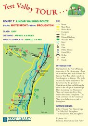
ROUTE U CIRCULAR WALKING ROUTE<br />
START & FINISH: BROUGHTON VILLAGE HALL<br />
CLASS: CHALLENGING<br />
DISTANCE: APPROX. 10 MILES<br />
TIME TO COMPLETE: APPROX. 3-4 HRS<br />
PLAY MIDDLE<br />
AREA WINTERSLOW<br />
9<br />
10<br />
PH<br />
11<br />
DALE<br />
COTTAGE<br />
RAMSHILL<br />
HOUSE<br />
8<br />
12<br />
Not to scale<br />
ASHLEY'S<br />
COPSE<br />
NOAD'S<br />
COPSE<br />
13<br />
UPPER NOAD'S<br />
COPSE<br />
BURRETTS<br />
GROVE<br />
CLARENDON WAY<br />
7<br />
6<br />
5<br />
BROUGHTON<br />
DOWN<br />
KEY<br />
WHITESHOOT HILL<br />
BUCKHOLT<br />
FARM<br />
INTRODUCTION<br />
This excellent walk through the wonderful countryside<br />
around <strong>Broughton</strong> takes in the lovely views across the chalk<br />
downl<strong>and</strong>s of <strong>Test</strong> <strong>Valley</strong>. It also follows a right of way across<br />
the ‘Turret’ at <strong>Broughton</strong> Down, which is owned by the<br />
Hampshire Wildlife Trust, where dogs must be kept on a lead.<br />
Just over halfway round, the walk drops into Middle<br />
Winterslow where you can stop for refreshments at the Lion’s<br />
Head Pub, alternatively the walk provides many spots for a<br />
picnic. The walk heads back to <strong>Broughton</strong> along the<br />
Clarendon Way, the Salisbury to Winchester Roman Road.<br />
14<br />
4<br />
<strong>Route</strong><br />
Footpath<br />
Road<br />
Road used as<br />
a Public Path<br />
BROUGHTON DOWN<br />
FARM<br />
THE TURRET<br />
SMITH'S PLANTATION<br />
3<br />
2<br />
RESR<br />
PH<br />
S/F<br />
REFRESHMENTS<br />
Wooded Area<br />
Public House<br />
Church<br />
Stile<br />
Gate<br />
<strong>Start</strong>/<strong>Finish</strong><br />
PH<br />
VILLAGE HALL<br />
1<br />
S/F<br />
The Tally Ho!, <strong>Broughton</strong><br />
The Greyhound Pub, <strong>Broughton</strong><br />
The Lion’s Head Pub, Middle<br />
Winterslow<br />
Explorer 131<br />
Romsey, Andover <strong>and</strong> <strong>Test</strong> <strong>Valley</strong>
THE NUMBERS ARE SHOWN IN THE SKETCH MAP OVERLEAF.<br />
START: <strong>Broughton</strong> <strong>Village</strong> Hall<br />
1<br />
2<br />
3<br />
4<br />
5<br />
6<br />
7<br />
8<br />
9<br />
10<br />
11<br />
12<br />
13<br />
14<br />
From <strong>Broughton</strong> <strong>Village</strong> Hall turn left. Turn left again at the Greyhound Pub <strong>and</strong><br />
after about 100 metres turn first right next to a house called the Knap then left onto a<br />
footpath which runs behind houses up to the road. Turn right <strong>and</strong> at the T junction<br />
turn right then left into Buckholt Road.<br />
At the end of the road take the track diagonally right uphill, which is signposted<br />
‘Clarendon Way’ <strong>and</strong> walk under vehicle restriction barrier. At the top of the hill<br />
take the right fork.<br />
Soon, take the narrow path on the right at the edge of the plantation. Walk along<br />
The Turret keeping to the Hampshire Wildlife Trust Reserve Path where all dogs<br />
must be kept on a lead. At the end of the reserve there is a small gate taking you<br />
out onto a wide track <strong>and</strong> from here there are splendid views.<br />
At this track turn right <strong>and</strong> walk down Whiteshoot Hill. At the bottom, bear left<br />
on the track (ignoring a narrow path that leads to <strong>Broughton</strong> Down Farm).<br />
Continue on the path for approximately 3 ⁄4 mile till you reach a tarmac road.<br />
Turn left at this road <strong>and</strong> continue ahead for 3 ⁄4 mile.<br />
At the left h<strong>and</strong> bend, look for a byway sign behind holding pens at corner on the<br />
right. Take this path downhill for some 200 metres before turning left through the<br />
gateway.<br />
Follow the footpath uphill <strong>and</strong> along the ridge. Walk through the gateway by the<br />
stile, over the field to Ashley’s Copse. Turn left <strong>and</strong> follow the track alongside the<br />
copse <strong>and</strong> past the entrance to Ramshill House on your right.<br />
Continue straight over cross tracks <strong>and</strong> out of the wood. Climb the stile in front of<br />
you into a field <strong>and</strong> go uphill along field edge to next rickety stile. Continue ahead<br />
to tarmac road <strong>and</strong> cross this.<br />
Take the footpath opposite between houses. At the next uneven road turn right<br />
onto the Flashett.<br />
Turn left at the next fork, ignoring other paths until a child’s play area on the right<br />
is reached, <strong>and</strong> turn left. Walk down the hill to the Lion’s Head Pub.<br />
From here turn left past the pub <strong>and</strong> then first right into Witt Road. Take the stony<br />
track to the left opposite Dale Cottage.<br />
At tarmac road turn right for approx 100 metres then take the footpath on the left.<br />
At end of footpath turn right onto the Clarendon Way. After approx. 1 mile cross<br />
narrow lane <strong>and</strong> carry straight on for another 1 ⁄2 mile until you come to Buckholt<br />
Farm. Follow the official diversion between barns.<br />
Continue straight ahead, over cross tracks <strong>and</strong> past a small reservoir on the right.<br />
Soon the plantation will be on the left. You can now retrace your steps downhill on<br />
the original paths into <strong>Broughton</strong> <strong>and</strong> the <strong>Village</strong> Hall.<br />
<strong>Test</strong> <strong>Valley</strong> Borough Council has made every effort to ensure this route card is correct. Details were correct<br />
at time of printing, however we cannot be held responsible for any errors or subsequent changes.