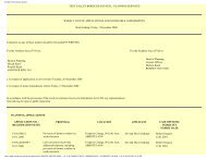
Cycle Route D1 - Start and Finish - Test Valley Borough Council
Cycle Route D1 - Start and Finish - Test Valley Borough Council
Cycle Route D1 - Start and Finish - Test Valley Borough Council

Create successful ePaper yourself
Turn your PDF publications into a flip-book with our unique Google optimized e-Paper software.
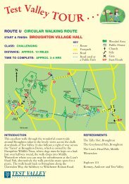
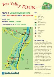
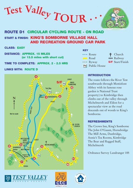
<strong>Test</strong> <strong>Valley</strong> TOUR . . .<br />
ROUTE <strong>D1</strong> CIRCULAR CYCLING ROUTE - ON ROAD<br />
START & FINISH: KING’S SOMBORNE VILLAGE HALL<br />
AND RECREATION GROUND CAR PARK<br />
CLASS: EASY<br />
DISTANCE: APPROX. 15 MILES<br />
(or 13.5 miles with short cut)<br />
TIME TO COMPLETE: APPROX. 2 - 2.5 HRS<br />
LINKS WITH: ROUTE D<br />
6<br />
Not to scale<br />
PH<br />
5<br />
DUNBRIDGE<br />
Station MOTTISFONT<br />
7<br />
Annie’s Tea<br />
Rooms<br />
B3084<br />
RIVER TEST<br />
MOTTISFONT<br />
ABBEY<br />
Alternative Road<br />
<strong>Route</strong><br />
8<br />
4<br />
A3057<br />
PH<br />
Old<br />
Station<br />
9<br />
<strong>Test</strong> Way<br />
3<br />
PH<br />
HORSEBRIDGE<br />
A3057<br />
MICHELMERSH<br />
PH<br />
1<br />
2<br />
A3057<br />
KINGS<br />
SOMBORNE<br />
10<br />
12<br />
11<br />
ELDON<br />
CHURCH<br />
KEY<br />
PH<br />
<strong>Route</strong><br />
Road<br />
Byway<br />
Public House<br />
S/F<br />
INTRODUCTION<br />
Church<br />
Railway<br />
<strong>Start</strong>/<strong>Finish</strong><br />
The route follows the River <strong>Test</strong><br />
southwards through Mottisfont<br />
Abbey with its famous rose<br />
garden is National Trust<br />
property) to Kimbridge then<br />
climbs out of the valley through<br />
Michelmersh <strong>and</strong> Eldon for a<br />
spectacular view as the road<br />
descends out of woods to King’s<br />
Somborne.<br />
REFRESHMENTS<br />
The Crown Inn, King’s Somborne<br />
The John O’Gaunt, Horsebridge<br />
The Mill Arms, Dunbridge,<br />
Annie’s Tea Rooms, Kimbridge<br />
The Bear <strong>and</strong> Ragged Staff,<br />
Michelmersh<br />
Ordnance Survey L<strong>and</strong>ranger 185
THE NUMBERS ARE SHOWN IN THE SKETCH MAP OVERLEAF.<br />
START: King’s Somborne Village Hall<br />
1<br />
2<br />
3<br />
4<br />
5<br />
6<br />
7<br />
8<br />
9<br />
10<br />
11<br />
12<br />
Turn left from village hall car park onto A3057 (CARE, BUSY ROAD).<br />
In 1/2 mile turn right into Horsebridge Road (signposted Horsebridge).<br />
Turn right (signposted Houghton). John O’Gaunt pub on right. Over River <strong>Test</strong>.<br />
<strong>Test</strong> Way off-road route crosses here. (Divert left along <strong>Test</strong> Way for 200 yds to<br />
view former Horsebridge Station, now a private residence).<br />
Straight on at Houghton (signposted Dunbridge). Note historic Stockbridge Rural<br />
District <strong>Council</strong> signpost.<br />
In Mottisfont, turn right into Hatt Lane (signposted Millennium Walk). To visit<br />
abbey continue through village, over channel of River <strong>Test</strong> <strong>and</strong> entrance to abbey is<br />
on left).<br />
Turn left at T-junction (signposted Dunbridge). Descend hill, over level crossing <strong>and</strong><br />
follow round to left into Dunbridge Lane (Mill Arms pub on right).<br />
After 1 mile, turn left (signposted Kimbridge). Over level crossing (Annie’s tea<br />
rooms <strong>and</strong> Kimbridge Farm Shop on left) <strong>and</strong> over bridges across the River <strong>Test</strong> to<br />
junction with A3057.<br />
Turn right <strong>and</strong> immediately left (CARE, BUSY ROAD) into Mesh Road (Bear &<br />
Ragged Staff pub on left).<br />
Turn right at crossroads at top of hill, then right (signposted Braishfield). Option<br />
here to bear right into Church Road to visit 12th century church.<br />
Continue through Michelmersh <strong>and</strong> at staggered crossroads turn left.<br />
Follow road round to left (signposted King’s Somborne) <strong>and</strong> then fork left<br />
(signposted Eldon). Climb for a mile to Eldon <strong>and</strong> visit the St John the Baptist 12th<br />
century church, now in the care of the Churches Conservation Trust. Continue<br />
along road through woods for 1 1/2 miles until you suddenly come upon the<br />
dramatic view over King’s Somborne <strong>and</strong> the <strong>Test</strong> <strong>Valley</strong>.<br />
Descend to King’s Somborne. Turn left at T-junction, then left at church on to<br />
A3057 (CARE BUSY ROAD), then left again into village hall <strong>and</strong> recreation<br />
ground car park.<br />
Alternative route between points 5 - 8 which shortens route by 11 /2 miles.<br />
In Mottisfont, follow road round to left (signposted Mottisfont Abbey). Cross<br />
River <strong>Test</strong> <strong>and</strong> continue to junction with A3057. Use cycle path traffic isl<strong>and</strong> to<br />
cross road <strong>and</strong> turn right (signposted Romsey). Use cycle path as far as Bear <strong>and</strong><br />
Ragged Staff pub. Turn left into Mesh Road.<br />
<strong>Test</strong> <strong>Valley</strong> <strong>Borough</strong> <strong>Council</strong> has made every effort to ensure this route card is correct. Details were correct<br />
at time of printing, however we cannot be held responsible for any errors or subsequent changes.