Observations of foehn interaction with lake breeze and valley wind ...
Observations of foehn interaction with lake breeze and valley wind ...
Observations of foehn interaction with lake breeze and valley wind ...

You also want an ePaper? Increase the reach of your titles
YUMPU automatically turns print PDFs into web optimized ePapers that Google loves.
<strong>Observations</strong> <strong>of</strong> <strong>foehn</strong> <strong>interaction</strong> <strong>with</strong> <strong>lake</strong> <strong>breeze</strong> <strong>and</strong> <strong>valley</strong><br />
<strong>wind</strong> circulations, Lake Tekapo, New Zeal<strong>and</strong>.<br />
Hamish A. McGowan<br />
School <strong>of</strong> Geography, Planning <strong>and</strong> Architecture, The University <strong>of</strong> Queensl<strong>and</strong>,<br />
St. Lucia, Brisbane 4072, Australia.<br />
1. Introduction<br />
Foehn <strong>wind</strong>s in the eastern Southern Alps, New Zeal<strong>and</strong>, known locally as the nor’wester, have been the focus<br />
<strong>of</strong> research since the early 1990s, in relation to their role in dust transport <strong>and</strong> dispersion (McGowan 1997),<br />
<strong>interaction</strong> <strong>with</strong> local thermally driven circulations (McGowan <strong>and</strong> Sturman 1996) <strong>and</strong> significance in alpine<br />
hydro-meteorology (Sinclair et al. 1996; Katzfey 1995a,b; Chater <strong>and</strong> Sturman 1998). The rationale for this<br />
research has been to answer significant knowledge gaps in the scientific underst<strong>and</strong>ing <strong>of</strong> <strong>foehn</strong> conditions in<br />
this region <strong>and</strong> to improve <strong>foehn</strong> forecasting in light <strong>of</strong> the rapid development <strong>of</strong> the alpine zone for tourism <strong>and</strong><br />
associated recreational activities, viticulture <strong>and</strong> silviculture. Foehn <strong>wind</strong> events also present a significant hazard<br />
to property <strong>and</strong> associated infrastructure <strong>and</strong> utilities, as well as to local aviation operations in support <strong>of</strong><br />
tourism.<br />
This paper presents observations <strong>of</strong> <strong>foehn</strong> <strong>interaction</strong> <strong>with</strong> thermally generated circulations including a <strong>lake</strong><br />
<strong>breeze</strong> circulation. Measurements were made during the austral summer in February 1999 as part <strong>of</strong> the Lake<br />
Tekapo Experiment (LTEX) (Sturman et al. 2003).<br />
2. Physical Setting <strong>and</strong> Instrumentation<br />
The Lake Tekapo hydro-catchment is situated approximately 180 km southwest <strong>of</strong> Christchurch in the central<br />
Southern Alps <strong>of</strong> New Zeal<strong>and</strong>. Lake Tekapo dominates the southern portion <strong>of</strong> the catchment <strong>with</strong> a surface<br />
area <strong>of</strong> approximately 87 km 2 <strong>and</strong> is bordered to the east <strong>and</strong> north by mountain ranges <strong>with</strong> peaks exceeding<br />
1800 m. The Godley <strong>and</strong> Macaulay River <strong>valley</strong>s located to the north <strong>of</strong> the <strong>lake</strong> are incised into these mountain<br />
ranges <strong>and</strong> airflow <strong>with</strong>in these <strong>valley</strong>s is primarily channelled up (southerly <strong>wind</strong>) or down <strong>valley</strong> (northerly<br />
<strong>wind</strong>). The surrounding mountain ranges effectively shelter the <strong>lake</strong> basin from gradient <strong>wind</strong>s allowing light<br />
diurnally reversing thermally driven circulations to dominate, while <strong>foehn</strong> <strong>wind</strong>s are most common in the<br />
headwaters <strong>of</strong> the catchment (McGowan et al. 2002). Vegetation cover consists <strong>of</strong> a mixture <strong>of</strong> exotic grasses<br />
<strong>and</strong> degraded tussock grassl<strong>and</strong> at lower altitudes, while at higher altitudes, taller snow tussocks predominate<br />
<strong>with</strong> some scrub. Vegetation cover above the snowline is scarce <strong>and</strong> snow, ice <strong>and</strong> rock surfaces prevail.<br />
Meteorological observations presented in this paper were collected by a network <strong>of</strong> automatic weather stations,<br />
pilot balloon stations <strong>and</strong> an instrumented light aircraft (Sturman et al. 2003), while synoptic analyses were<br />
provided by MetService, New Zeal<strong>and</strong>.<br />
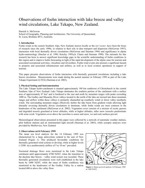
3. <strong>Observations</strong> on14 February 1999<br />
The mean sea level analysis for the 14 February 1999 was<br />
characterised by a large anticyclone centred to the east <strong>of</strong> New<br />
Zeal<strong>and</strong> (Figure 1). This produced favourable conditions for<br />
thermally generated <strong>wind</strong> systems to develop, while at higher levels<br />
(>2500 m) a northwesterly airflow <strong>of</strong> 5 to 10 ms -1 prevailed.<br />
Nocturnal drainage flows were monitored in the Lake Tekapo<br />
catchment until approximately 0700 NZST, when the transition to<br />
the daytime <strong>lake</strong> <strong>breeze</strong> – <strong>valley</strong> <strong>wind</strong> system was recorded. These<br />
thermally generated circulations were well established in the <strong>lake</strong><br />
basin by 1000 NZST, while the onset <strong>of</strong> <strong>foehn</strong> conditions was<br />
monitored in the headwaters <strong>of</strong> the Godley Valley by a station<br />
located 600 m above the <strong>valley</strong> floor.<br />
1008<br />
1000<br />
L<br />
1004<br />
5kts<br />
160E<br />
1008<br />
1016<br />
1025<br />
50S<br />
1008<br />
180<br />
1024<br />
H<br />
10kts<br />
40S<br />
30S<br />
Figure 1. Mean sea level analysis 14 February 1999<br />
at 1200 NZST.
Over the following four hours, the <strong>foehn</strong> front advanced down <strong>valley</strong><br />
eroding the local thermally generated flows from above, as seen in<br />
Figure 2. The <strong>foehn</strong> then decoupled from the surface approximately 5<br />
km north <strong>of</strong> the <strong>lake</strong> shoreline as it encountered the <strong>lake</strong> <strong>breeze</strong> front,<br />
which was associated <strong>with</strong> whirl<strong>wind</strong>s <strong>and</strong> associated dust<br />
entrainment. The <strong>foehn</strong> then remained decoupled from the surface<br />
before grounding midway down the <strong>lake</strong> between 1400 <strong>and</strong> 1500<br />
NZST. Coupling <strong>of</strong> the <strong>foehn</strong> to the cold <strong>lake</strong> surface is believed to<br />
have coincided <strong>with</strong> the descending limb <strong>of</strong> the <strong>lake</strong> <strong>breeze</strong> circulation<br />
cell which prevailed throughout the day over the northern <strong>lake</strong><br />
shoreline. The northerly <strong>foehn</strong> then decoupled from the surface again<br />
near the southern <strong>lake</strong> shoreline as it encountered the <strong>valley</strong> <strong>wind</strong><br />
originating from southeast <strong>of</strong> Tekapo Village (Figure 3). Pilot balloon<br />
flights conducted adjacent to Tekapo Village identified this airflow to<br />
be approximately 900 m deep beneath the prevailing gradient westerly<br />
airstream.<br />
Vertical mixing ratio pr<strong>of</strong>iles measured by an instrumented light<br />
aircraft between 1400 <strong>and</strong> 1500 NZST are presented in Figure 4. They<br />
show that below approximately 500 m agl. the mixing ratio pr<strong>of</strong>iles<br />
over the northern shoreline <strong>and</strong> south <strong>of</strong> Tekapo Village were similar,<br />
decreasing from 7 g kg -1 to 5.6 g kg -1 as the aircraft climbed through the<br />
local <strong>lake</strong> <strong>breeze</strong> <strong>and</strong> <strong>valley</strong> <strong>wind</strong> system respectively. However, over the<br />
middle <strong>of</strong> the <strong>lake</strong> the drier <strong>foehn</strong> airmass displayed mixing ratios <strong>of</strong> 4.5 g kg -1<br />
to 5.5 g kg -1 . These drier conditions were also monitored by weather stations<br />
located on the <strong>lake</strong>shore adjacent to the position <strong>of</strong> the aircraft sounding <strong>and</strong><br />
were associated <strong>with</strong> light northerly <strong>wind</strong>s <strong>of</strong> 3 to 4 ms -1 as shown in Figure 3.<br />
The airmass south <strong>of</strong> Lake Tekapo became drier above 500 m until about 900 m<br />
agl. Above this height, mixing ratio values remained nearly constant at<br />
approximately 4 g kg -1 reflecting larger scale airmass characteristics associated<br />
<strong>with</strong> the prevailing gradient westerly airflow. Over the northern shoreline,<br />
mixing ratios remained nearly constant at 5.5 g kg -1 between 500 m to 1100 m<br />
agl. before decreasing rapidly as the influence <strong>of</strong> surface moisture from<br />
surrounding mountain ranges became less. The mid-<strong>lake</strong> pr<strong>of</strong>ile indicates a<br />
more layered structure above 500 m than either <strong>of</strong> the other two pr<strong>of</strong>iles, but<br />
the general trend shown is a decrease in mixing ratio values <strong>with</strong> increasing<br />
height as the influence <strong>of</strong> local surface properties on the <strong>foehn</strong> airflow became<br />
less.<br />
Cessation <strong>of</strong> this event began at approximately 1530 NZST <strong>with</strong> the <strong>foehn</strong> front<br />
retreating up <strong>valley</strong>. This <strong>of</strong>ten coincides <strong>with</strong> the intrusion <strong>of</strong> the regional scale<br />
plain-mountain circulation into the Lake Tekapo Basin, as discussed by<br />
Kossmann et al. (2002). However, on this occasion the cessation <strong>of</strong> <strong>foehn</strong><br />
conditions appeared to be a function <strong>of</strong> reduced sensible heat flux causing a<br />
decoupling <strong>of</strong> the <strong>wind</strong> al<strong>of</strong>t from the surface in the study area. By 2000 NZST<br />
<strong>foehn</strong> conditions were confined to the headwaters <strong>of</strong> the Godley River <strong>valley</strong><br />
<strong>with</strong> local thermally generated <strong>wind</strong>s monitored at other sites in the <strong>lake</strong> basin<br />
including the onset <strong>of</strong> cold air drainage. Two hours latter the nocturnal drainage<br />
<strong>wind</strong> regime was fully established throughout the catchment.<br />
4. Summary<br />
This paper has presented observations <strong>of</strong> the complex <strong>interaction</strong> between the<br />
topographically modified <strong>foehn</strong> nor’wester <strong>and</strong> local thermally generated <strong>wind</strong>s<br />
Height agl.(m)<br />
2000<br />
1800<br />
1600<br />
1400<br />
1200<br />
1000<br />
800<br />
600<br />
400<br />
Anti-<strong>wind</strong>?<br />
Topographically channelled<br />
<strong>foehn</strong> airflow<br />
200<br />
0<br />
0400 0600 0800 1000 1200 1400 1600<br />
Wind speed Time (NZST)<br />
Long barbs 2.5ms-1, Short barbs 1.25ms-1 Valley <strong>wind</strong><br />
Mountain <strong>wind</strong><br />
Figure 2. Vertical pr<strong>of</strong>iles <strong>of</strong> <strong>wind</strong> speed <strong>and</strong><br />
direction calculated from pilot balloon flights<br />
conducted in the Godley Valley, 14 February<br />
1999.<br />
Southern Alps<br />
Godley River<br />
Tekapo<br />
Village<br />
S<br />
Legend<br />
Wind speed Scale<br />
5 ms<br />
N<br />
10 km<br />
-1<br />
S<br />
Lake<br />
Tekapo<br />
Foehn<br />
front<br />
Macaulay River<br />
Aircraft<br />
sounding<br />
S<br />
Figure 3. Surface <strong>wind</strong> field<br />
characteristics 14 February 1999 at<br />
1420 NZST.<br />
S
monitored in the Lake Tekapo hydro-catchment.<br />
<strong>Observations</strong> were made during weak to<br />
moderate trans-barrier gradient airflow, as<br />
indicated in Figures 1 <strong>and</strong> 2, suggesting that such<br />
conditions may occur more frequently than<br />
previously thought. Under these conditions, as<br />
monitored on the 14 February 1999, <strong>foehn</strong> onset<br />
occurred following sunrise <strong>and</strong> the onset <strong>of</strong><br />
surface heating, while cessation coincided <strong>with</strong><br />
sunset, or soon after, indicating a strong<br />
association between <strong>foehn</strong> occurrence <strong>and</strong> the<br />
surface energy balance – specifically sensible<br />
heat flux. During early February 1999 surface<br />
daytime temperatures over the dry alluvium in the<br />
Godley River <strong>valley</strong> typically exceeded 40°C, <strong>with</strong><br />
Height (m)<br />
Mixing Ratio (g kg -1 2200<br />
2000<br />
1800<br />
1600<br />
1400<br />
1200<br />
1000<br />
800<br />
600<br />
400<br />
200<br />
0<br />
0 1 2 3 4 5 6 7 8<br />
Legend<br />
)<br />
Mid-<strong>lake</strong> Northern shoreline South <strong>of</strong> Tekapo Village<br />
Figure 4. Vertical mixing ratio pr<strong>of</strong>iles obtained by a light aircraft<br />
between 1400 – 1500 NZST, 14 February 1999.<br />
corresponding sensible heat flux density values <strong>of</strong> 130 to 200 Wm 2 . The resulting convection combined <strong>with</strong><br />
topographic channelling <strong>of</strong> airflow is believed to trigger the observed daytime grounding <strong>of</strong> the <strong>foehn</strong>, which is<br />
typically confined to the Godley <strong>and</strong> Macaulay River <strong>valley</strong>s. Local <strong>and</strong> regional scale thermotopographic<br />
circulations dominate elsewhere in the catchment under such conditions, including a <strong>lake</strong> <strong>breeze</strong> circulation<br />
which displays a complex <strong>interaction</strong> <strong>with</strong> the <strong>foehn</strong>. A climatology <strong>of</strong> <strong>foehn</strong> events is now planned to improve<br />
knowledge <strong>of</strong> <strong>foehn</strong> occurrence in the headwaters <strong>of</strong> alpine catchments such as Lake Tekapo.<br />
Acknowledgements:<br />
The LTEX programme was funded by Marsden Fund Grant UOC602, awarded by the Royal Society <strong>of</strong> New<br />
Zeal<strong>and</strong>. The author acknowledges the assistance <strong>of</strong> all members <strong>of</strong> the LTEX programme <strong>and</strong> residents <strong>of</strong> Lake<br />
Tekapo who allowed the installation <strong>of</strong> monitoring equipment on their property. This study was completed <strong>with</strong><br />
funding from The University <strong>of</strong> Queensl<strong>and</strong> <strong>and</strong> the Ian Potter Foundation, Melbourne, Australia.<br />
References:<br />
Chater, A.M. <strong>and</strong> Sturman, A.P., 1998: Atmospheric conditions influencing the orographic spillover <strong>of</strong> westerly<br />
rainfall into the Waimakariri Catchment, Southern Alps, New Zeal<strong>and</strong>. International Journal <strong>of</strong><br />
Climatology, 18, pp77 - 92.<br />
Katzfey, J.J., 1995a: Simulations <strong>of</strong> extreme New Zeal<strong>and</strong> precipitation events. Part 1: Sensitivity to orography<br />
<strong>and</strong> resolution. Monthly Weather Review, 123, pp737-754.<br />
Katzfey, J.J., 1995b: Simulations <strong>of</strong> extreme New Zeal<strong>and</strong> precipitation events. Part 2: Mechanisms <strong>of</strong><br />
precipitation development. Monthly Weather Review, 123, pp755 - 775.<br />
Kossmann, M., A.P. Sturman, P. Zawar-Reza, H.A. McGowan, A. Oliphant, I.F. Owens <strong>and</strong> R. Spronken-Smith,<br />
2002: Analysis <strong>of</strong> the <strong>wind</strong> field <strong>and</strong> heat budget in an alpine <strong>lake</strong> basin during summertime fair<br />
weather conditions. Meteorology <strong>and</strong> Atmospheric Physics, 81, pp27-52.<br />
McGowan, H. A. 1997: Meteorological controls on <strong>wind</strong> erosion during <strong>foehn</strong> <strong>wind</strong> events in the eastern<br />
Southern Alps, New Zeal<strong>and</strong>. Canadian Journal <strong>of</strong> Earth Sciences, 34, pp1477- 1485.<br />
McGowan, H. A. <strong>and</strong> Sturman, A. P. 1996: Regional <strong>and</strong> local scale characteristics <strong>of</strong> <strong>foehn</strong> <strong>wind</strong> events over<br />
the South Isl<strong>and</strong> <strong>of</strong> New Zeal<strong>and</strong>. Meteorology <strong>and</strong> Atmospheric Physics, 58, pp151-164.<br />
McGowan, H. A., Sturman, A. P., Kossmann, M. <strong>and</strong> Zawar-Reza, P. 2002: <strong>Observations</strong> <strong>of</strong> <strong>foehn</strong> onset in the<br />
Southern Alps, New Zeal<strong>and</strong>. Meteorology <strong>and</strong> Atmospheric Physics 79, 3-4, pp215-230.<br />
Sturman, A.P.,Bradley, S., Drummond, P., Grant, K., Gudiksen, P., Kossmann, M., McGowan, H.A., Oliphant,<br />
A., Owens, I.F., Powell, S., Spronken-Smith, R., <strong>and</strong> Zawar-Reza, P. 2003: The Lake Tekapo<br />
Experiment (LTEX): an investigation <strong>of</strong> atmospheric boundary layer processes in complex terrain<br />
Bulletin American Meteorological Society. (In Press)