Weed Spotter Queensland Network Newsletter Autumn 2012 edition
Weed Spotter Queensland Network Newsletter Autumn 2012 edition
Weed Spotter Queensland Network Newsletter Autumn 2012 edition

You also want an ePaper? Increase the reach of your titles
YUMPU automatically turns print PDFs into web optimized ePapers that Google loves.
Parkinsonia Dieback Project<br />
in the Desert Channels<br />
Parkinsonia (Parkinsonia aculeata) is a highly invasive<br />
weed of national significance, which has massive<br />
potential to spread through inland waterways and<br />
rangelands.<br />
Thanks to the combination of sharp eyes of NT Barkly<br />
Landcare Officer, Colleen Westover, who noticed<br />
unexplained deaths of Parkinsonia in 2004, a threeyear<br />
PhD study at the University of <strong>Queensland</strong> (UQ)<br />
by Naomi Diplock and the persistence of Dr Vic Galea,<br />
Associate Professor in plant pathology at UQ, around<br />
200 local fungal cultures have been identified which can<br />
cause Parkinsonia dieback. This is a naturally occurring<br />
event which kills Parkinsonia.<br />
Over the past 18 months landholders in western<br />
<strong>Queensland</strong> have been participating in a trial funded by<br />
Meat and Livestock Australia to test the effectiveness<br />
of pathogens. Coordinated by UQ, in partnership with<br />
regional NRM groups, 14 field days have been held (eight<br />
in 2010, and six follow up in 2011), and 70 trial sites<br />
have been set up with individual landholders. Results<br />
are promising, with trial participants reporting a range of<br />
responses including death and sickness of Parkinsonia<br />
trees in a variety of land types. The project leader is<br />
Dr Vic Galea, UQ, and supporters are Desert Channels<br />
Group, Southern Gulf Catchments, South West NRM,<br />
National Prickle Bush Management Group, Capricorn<br />
Pest Management and Biodiversity <strong>Queensland</strong>.<br />
Sue Ackers, Desert Channels <strong>Queensland</strong> Inc.<br />
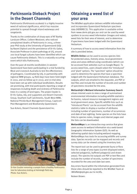
Dr Ken Goulter removing a sample from a healthy Parkinsonia<br />
tree for laboratory testing at Holmleigh field day.<br />
Photo: Sue Ackers.<br />
Page 4<br />
Obtaining a weed list of<br />
your area<br />
The WildNet application delivers wildlife information<br />
and incorporates <strong>Queensland</strong> Herbarium specimen<br />
data (HERBRECS). This application is available online<br />
from and can be used by weed<br />
spotters to access weed information (images and notes),<br />
weed lists for their area of interest, and to determine<br />
if specimens have been lodged with the <strong>Queensland</strong><br />
Herbarium.<br />
A summary of how to access weed information from the<br />
site is provided below.<br />
Wildlife Online can be used to access species lists<br />
for protected areas, forestry areas, local government<br />
areas and areas defined using coordinates (which can<br />
be accessed from websites such as Google Maps). To<br />
access weed lists, users should select the ‘introduced’<br />
and ‘plant’ options. The ‘specimen’ option should be<br />
used to determine the species that have a specimen<br />
lodged with the <strong>Queensland</strong> Herbarium database. The<br />
outputs, which are emailed to the requester, are PDF or<br />
text files and include the number of records and number<br />
of specimens recorded for the area.<br />
WetlandInfo’s Wetland Information Summary Search<br />
allows internet users to view a range of summarised<br />
environmental information including wildlife statistics<br />
for basins, natural resource management regions and<br />
local government areas. Specific wildlife lists such as<br />
‘Introduced Plants’ can be accessed from the wildlife<br />
statistics table to display a number of attributes<br />
including number of specimens, number of occurrences<br />
and date of last sighting. Some species on the lists have<br />
links to species notes, images and internet pages and<br />
the lists can be downloaded.<br />
WetlandMaps is an interactive map service that gives<br />
users access to wetland information via a web-based<br />
Geographic Information System (GIS). As well as<br />
delivering spatial data including wetland mapping,<br />
WetlandMaps has tools for accessing wildlife and survey<br />
data. Species records can be mapped and records and<br />
survey data can be viewed using the inventory tool.<br />
The report tool can be used to generate fauna or flora<br />
lists for a range of area types (current displayed extent,<br />
selected polygon(s), buffered polygon(s) and drawn<br />
areas). The species list outputs are PDF or text files and<br />
include the number of records, number of specimens<br />
recorded for the area and date last seen.<br />
Any errors found within the information generated from<br />
these sites should be reported to the WildNet Team at<br />
to rectify.<br />
Noleen Brown.