Planetary Geology pdf - Solar System Exploration
Planetary Geology pdf - Solar System Exploration
Planetary Geology pdf - Solar System Exploration

You also want an ePaper? Increase the reach of your titles
YUMPU automatically turns print PDFs into web optimized ePapers that Google loves.
Exercise<br />
Two<br />
Suggested Correlation of Topics<br />
Geomorphology, gradation, impact cratering,<br />
tectonism, volcanism, photography<br />
Purpose<br />
The objective of this exercise is to introduce students<br />
to landforms produced by the four major geologic<br />
processes using aerial photographs.<br />
Ruler (metric)<br />
Materials<br />
Background<br />
Geologic processes often result in distinctive<br />
landforms or surface features. For example, steep,<br />
conical hills with small summit craters are distinc-<br />
Geologic Landforms<br />
Seen on Aerial Photos<br />
Instructor Notes<br />
N<br />
Exercise Two: Geologic Landforms<br />
Seen on Aerial Photos<br />
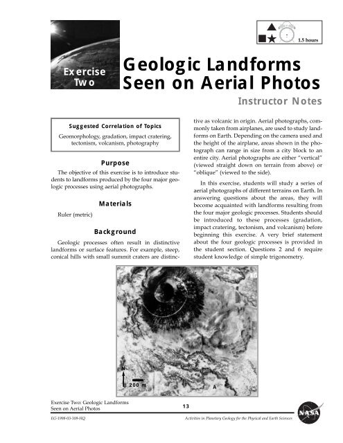
200 m<br />
13<br />
tive as volcanic in origin. Aerial photographs, commonly<br />
taken from airplanes, are used to study landforms<br />
on Earth. Depending on the camera used and<br />
the height of the airplane, areas shown in the photograph<br />
can range in size from a city block to an<br />
entire city. Aerial photographs are either ÒverticalÓ<br />
(viewed straight down on terrain from above) or<br />
ÒobliqueÓ (viewed to the side).<br />
In this exercise, students will study a series of<br />
aerial photographs of different terrains on Earth. In<br />
answering questions about the areas, they will<br />
become acquainted with landforms resulting from<br />
the four major geologic processes. Students should<br />
be introduced to these processes (gradation,<br />
impact cratering, tectonism, and volcanism) before<br />
beginning this exercise. A very brief statement<br />
about the four geologic processes is provided in<br />
the student section. Questions 2 and 6 require<br />
student knowledge of simple trigonometry.<br />
EG-1998-03-109-HQ Activities in <strong>Planetary</strong> <strong>Geology</strong> for the Physical and Earth Sciences<br />
A<br />
1.5 hours
1. a. The volcano has a circular base and a circular<br />
crater. The sides of the cone are gullied<br />
from erosion.<br />
b. A road.<br />
2. a. ~564 m.<br />
b. 30.6¡.<br />
3. a. They are somewhat rugged.<br />
b. The source of the lava is probably at the<br />
base of the cinder cone near the road.<br />
4. a. They are both generally conical in shape,<br />
with a central depression at the top.<br />
b. Mt. Tavurur is much larger, and its crater is<br />
more irregular.<br />
5. The crater is scalloped, suggesting that it has<br />
been reshaped several times by multiple eruptions.<br />
6. x=~446 m, 27.7¡.<br />
7. The slopes of a volcano may be affected by the<br />
following: Single versus multiple eruptions,<br />
type of material (ash versus lava), viscosity<br />
(ÒrunnynessÓ) of the lava (dependent on its<br />
temperature and composition), length of lava<br />
flows, erosion by wind or rain after volcano is<br />
formed.<br />
8. It cuts through the mountains and is expressed<br />
as a depression or trough. The rocks along the<br />
fault were ground together and weakened, so<br />
that they were more easily eroded than the<br />
rocks away from the fault.<br />
9. a. A road would have been cut and separated.<br />
b. There are at least two off-set features<br />
(drainage valleys) along the fault: near the<br />
middle of the photo, and near the bottom of<br />
the photo (harder to see the offset) .<br />
10. Blocks A and C must move apart in the horizontal<br />
plane ( ). The area is undergoing<br />
extensional stresses.<br />
11. a. The alluvium is material eroded from the<br />
mountains.<br />
b. All three erosional agents have acted to<br />
produce materials eroded from the mountains,<br />
but water was the main agent.<br />
c. All three agents, but mostly water.<br />
d. It would be eroded by the agents of wind,<br />
Answer Key<br />
14<br />
water, and gravity. For example, sand dunes<br />
are visible alongside the fans, evidence of<br />
erosion by the wind.<br />
12. a. It removes material from its banks, and carries<br />
material from one place to another. It<br />
deposits material to form sandbars (erosion,<br />
transportation, deposition).<br />
b. The channels change position with time.<br />
Dry and semi-dry (ponds present) channels<br />
are visible in the foreground of the photo.<br />
13. a. It is roughly circular, with squared sides.<br />
b. The walls are gullied, indicating erosion by<br />
running water. The flat bottom suggests it<br />
has been infilled.<br />
14. About 48 times. (Crater diameter is about<br />
1200 m.)<br />
15. a. Meteor Crater is much wider and the sides<br />
are not as steep. Impact craters excavate<br />
(occur at ground level and dig out below<br />
ground level), volcanic cones and craters<br />
are built up above ground level (positive<br />
relief features).<br />
b. They have the same circular shape and<br />
have a crater in the center.<br />
16. a. Circular. Somewhat subdued appearance:<br />
the rim appears worn, and not very distinct.<br />
The center of the crater seems to have been<br />
partly filled in with sediment and sand<br />
dunes.<br />
b. Meteor Crater appears to be more distinct<br />
and deeper than Roter Kamm.<br />
17. a. The crater is much wider and not nearly as<br />
high or steep.<br />
b. They are both very circular and have raised<br />
rims.<br />
18. a. River valleyÑgradation<br />
b. GrabenÑtectonism (rivers are flowing into<br />
this graben)<br />
c. Lava flowÑvolcanism<br />
d. Cinder coneÑvolcanism<br />
e. Lava flowÑvolcanism<br />
f. Lava flow in a pre-existing river valleyÑ<br />
gradation, followed by volcanism<br />
Exercise Two: Geologic Landforms<br />
Seen on Aerial Photos<br />
Activities in <strong>Planetary</strong> <strong>Geology</strong> for the Physical and Earth Sciences EG-1998-03-109-HQ
g. GrabenÑtectonism (lava flows have<br />
entered parts of this graben)<br />
19. Near letter G, volcanic material flowed into the<br />
pre-existing graben valley in two separate<br />
places. The flow spread out in a fan shape.<br />
20. _3_ River and stream valleys formed<br />
_5_ dark (black) volcanic materials were<br />
Exercise Two: Geologic Landforms<br />
Seen on Aerial Photos<br />
Answer Key, continued<br />
EG-1998-03-109-HQ Activities in <strong>Planetary</strong> <strong>Geology</strong> for the Physical and Earth Sciences<br />
15<br />
deposited<br />
_4_ medium gray volcanic flows were deposited<br />
_1_ light gray plains formed<br />
_2_ tectonism produced grabens<br />
21. On Earth they have been obliterated by tectonic<br />
processes and agents of gradation (wind and
Exercise<br />
Two<br />
Volcanism<br />
Purpose<br />
By studying aerial photographs you will learn to<br />
identify different kinds of geologic features, tell<br />
how they differ from one another, and learn the<br />
processes involved in their formation.<br />
Ruler (metric)<br />
Materials<br />
Introduction<br />
The four major geologic processes (gradation,<br />
impact cratering, tectonism, and volcanism) each<br />
produce distinct landforms. A landform can be<br />
Questions<br />
1. Examine the cinder cone of Mount Capulin, New Mexico, shown in Figure 2.1. The depression at its summit<br />
is referred to as a volcanic crater.<br />
a. Describe the general shape of the cone and the volcanic crater at the top.<br />
b. What is the white spiral line from the base of the cone to the crater rim?<br />
Based on the elevation of Mt. Capulin (334m) and the information provided by the aerial photo, the slope<br />
of the volcano's sides can be calculated. This simple sketch of Mt. Capulin will help.<br />
Exercise Two: Geologic Landforms<br />
Seen on Aerial Photos<br />
Name<br />
Geologic Landforms<br />
Seen on Aerial Photos<br />
EG-1998-03-109-HQ Activities in <strong>Planetary</strong> <strong>Geology</strong> for the Physical and Earth Sciences<br />
17<br />
identified based on its shape and form, or its<br />
morphology. Volcanism is the eruption of melted<br />
rock (called magma) and its associated gases onto<br />
the surface of the Earth. Volcanism commonly produces<br />
volcanoes and volcanic flows. Tectonism<br />
involves the movement of rock by fracturing and<br />
faulting, which results in earthquakes. Gradation<br />
involves the erosion, transportation, and deposition<br />
of surface materials. On Earth, running water, wind,<br />
gravity and ice are the major agents of gradation.<br />
Impact cratering occurs when material from outside<br />
the EarthÕs atmosphere (such as meteoroids and<br />
comets) strike the surface. The aerial photographs in<br />
this exercise will help you recognize landforms and<br />
the geological processes that formed them. These<br />
processes act on other planets, where they can generate<br />
similar landforms.<br />
x<br />
y
2. a. Using your ruler and the scale bar on Figure 2.1, determine (in meters) the distance x, measured from<br />
the base of the cone to the edge of the crater at the top of the cone.<br />
b. The height y of the cone is 334m. Use trigonometry to estimate the average slope of the volcanoÕs<br />
sides.<br />
Examine the lava flow labeled A.<br />
3. a. Does its surface appear rugged or smooth?<br />
b. Trace the flow back to its point of origin. Where is the probable source of the flow?<br />
Study Mt. Tavurur volcano, New Guinea, in Figure 2.2.<br />
4. a. How is the volcano similar to Mt. Capulin?<br />
b. How is it different?<br />
5. Mt. Tavurur has erupted many times during its formation. How does the shape of the summit crater support<br />
this statement?<br />
6. As you did for Mt. Capulin, estimate the slope of Mt. Tavurur's flanks. Draw and label a sketch similar to<br />
the one provided for Mt. Capulin. The height of Mt. Tavurur is 225m. Measure length x from the edge of<br />
the volcano at the ocean to the rim of the summit crater.<br />
Sketch area<br />
18<br />
Exercise Two: Geologic Landforms<br />
Seen on Aerial Photos<br />
Activities in <strong>Planetary</strong> <strong>Geology</strong> for the Physical and Earth Sciences EG-1998-03-109-HQ
7. List some factors that might affect the slope of a volcano.<br />
Tectonism<br />
Southern California is cut by many faults. These are usually visible on aerial photographs as straight or gently<br />
curving linear features, often forming distinct divisions between landforms. Examine Figure 2.3, an oblique<br />
view of the San Andreas fault (arrow). A fairly straight valley trends from the bottom toward the top of the<br />
photo. (The dark line to the left of the fault is a canal lined with vegetation.) Over time, the ground to the left<br />
of the fault is moving away from us with respect to the ground to the right of the fault.<br />
8. In what way does the fault affect the morphology of the mountains in this photo?<br />
Tear a piece of paper in half. Place the two halves side by side and draw a line from one piece across onto<br />
the other. Making certain that the edges of the pieces remain in contact, slide the paper on the left away<br />
from you and the paper on the right towards you. This motion illustrates what occurs along the San<br />
Andreas fault and how it affects the features along it. This type of fault is called a strike-slip fault.<br />
9. a. What would have happened if the line on the paper was actually a road crossing a fault?<br />
b. Are there any features like this in Figure 2.3?<br />
One landform distinctive to tectonism is called a graben (see Figure 2.4). A graben is a valley bounded on both<br />
sides by normal faults. The movement along these faults is vertical, with the central block moving downward<br />
in relation to the sides.<br />
10. For block B to have enough space to move down, what has to occur to blocks A and C in Figure 2.4?<br />
Figure 2.4. Diagram of a graben.<br />
Exercise Two: Geologic Landforms<br />
Seen on Aerial Photos<br />
A C<br />
B<br />
EG-1998-03-109-HQ Activities in <strong>Planetary</strong> <strong>Geology</strong> for the Physical and Earth Sciences<br />
19
Gradation<br />
Figure 2.5 is a vertical photo of alluvial fans at Stovepipe Wells, Death Valley, California. These features result<br />
from the build up of alluvium (gravel, sand, and clay) that accumulates at the base of mountain slopes. ÒFanÓ<br />
describes the general shape of the feature.<br />
11. a. What is the source of the alluvium that makes up the fans?<br />
b. Which agents of erosion (wind, water, and/or gravity) might have generated the alluvium?<br />
c. Which agent(s) deposited it?<br />
d. Once deposited, how might the alluvium be further eroded?<br />
Figure 2.6 is a photograph of the Delta River, a braided stream in central Alaska. This river carries melt<br />
water and silt from glaciers to the Pacific Ocean. Rivers of this type are usually shallow. Because they are<br />
laden with sediments, they often deposit the sediments to form sandbars. These sandbars redirect the river<br />
flow, giving the river its branching, braided appearance.<br />
12. a. How is the Delta River an agent of gradation that works to change the surface?<br />
b. Do the individual river channels appear to be permanent, or do they change position with time? How<br />
do you know?<br />
Impact Craters<br />
Examine the photographs of Meteor Crater, an impact crater in Arizona. Figure 2.7 (a) is a vertical aerial photograph,<br />
and Figure 2.7 (b) is an oblique view.<br />
13. a. Describe the craterÕs general shape.<br />
b. Meteor Crater is one of the best preserved craters in the world. However, it has been eroded somewhat.<br />
List some evidence for this.<br />
14. The meteor that impacted here was about 25m across. Measure the diameter of Meteor Crater. How many<br />
times bigger than the meteor is the crater?<br />
15. a. Describe how the morphology of Meteor Crater is different from the volcanic landforms shown in<br />
Figures 2.1 and 2.2.<br />
20<br />
Exercise Two: Geologic Landforms<br />
Seen on Aerial Photos<br />
Activities in <strong>Planetary</strong> <strong>Geology</strong> for the Physical and Earth Sciences EG-1998-03-109-HQ
. How is it similar?<br />
Examine the view of Roter Kamm impact crater, Namibia, Figure 2.8.<br />
16. a. Describe its morphology?<br />
b. Compared to Meteor Crater, does it look fresh or eroded? Explain.<br />
17. a. How is Roter Kamm crater different from the volcanic landforms of Figures 2.1 and 2.2?<br />
b. How do they look similar?<br />
Synthesis<br />
Different processes produce landforms that are different in morphology. Linear, straight features are generally<br />
tectonic in origin. More sinuous features (such as river valleys) are typically formed by gradational processes.<br />
Volcanism forms flows in irregular patches and cones.<br />
A part of central Arizona is shown in Figure 2.9. Represented here are landforms shaped by three of the four principal<br />
geologic processes. For each labeled landform, identify its type and the process that formed it.<br />
18. A. E.<br />
B. F.<br />
C. G.<br />
D.<br />
19. Identify a place in the photograph where a pre-existing graben has affected the morphology of a later volcanic<br />
flow. Sketch what you see, and describe in words what happened. (Use the sketch area on the next page.)<br />
Exercise Two: Geologic Landforms<br />
Seen on Aerial Photos<br />
EG-1998-03-109-HQ Activities in <strong>Planetary</strong> <strong>Geology</strong> for the Physical and Earth Sciences<br />
21
Sketch area<br />
20. Determine the sequence of events that affected this region. Order the events below from first occurring (1)<br />
to most recent (5).<br />
___ river and stream valleys formed<br />
___ dark (black) volcanic materials were deposited<br />
___ medium gray volcanic flows were deposited<br />
___ light gray plains formed<br />
___ tectonism produced grabens<br />
21. Large impacting objects such as asteroids have rarely fallen to Earth in the last few million years, but billions<br />
of years ago they were very common. Assuming that throughout the geologic history of Earth, as many<br />
impacts have occurred as on the Moon, then why do we see so few craters on the Earth today, while so many<br />
remain visible on the Moon?<br />
22<br />
Exercise Two: Geologic Landforms<br />
Seen on Aerial Photos<br />
Activities in <strong>Planetary</strong> <strong>Geology</strong> for the Physical and Earth Sciences EG-1998-03-109-HQ
N<br />
200 m<br />
Figure 2.1. Mount Capulin, New Mexico; vertical aerial photograph. (University of Illinois Catalog of Stereogram Aerial<br />
Photographs #105.)<br />
Exercise Two: Geologic Landforms<br />
Seen on Aerial Photos<br />
EG-1998-03-109-HQ Activities in <strong>Planetary</strong> <strong>Geology</strong> for the Physical and Earth Sciences<br />
23<br />
A<br />
AG
24<br />
N<br />
200 km<br />
Figure 2.2. Mt. Tavurur. Vertical view of a composite volcano on the eastern Pacific island of New Britain, Papua, New Guinea. (Univ. Of Illinois<br />
Catalog of Stereogram Aerial Photographs, #102.)<br />
Exercise Two: Geologic Landforms<br />
Seen on Aerial Photos<br />
Activities in <strong>Planetary</strong> <strong>Geology</strong> for the Physical and Earth Sciences EG-1998-03-109-HQ
N<br />
Figure 2.3. Oblique aerial view of a part of the San Andreas fault north of Los Angeles. North is to the top right. The<br />
foreground is approximately 3.5 km across. (photograph by Robert E. Wallace, U.S. Geological Survey).<br />
Exercise Two: Geologic Landforms<br />
Seen on Aerial Photos<br />
EG-1998-03-109-HQ Activities in <strong>Planetary</strong> <strong>Geology</strong> for the Physical and Earth Sciences<br />
25
Figure 2.5. Vertical view of alluvial fans near Stovepipe Wells, Death Valley, California. Panamint mountains lie to the<br />
south. North is to the bottom left. (University Of Illinois Catalog of Stereogram Aerial Photographs, #125).<br />
Figure 2.6. The Delta<br />
River, a braided<br />
stream in central<br />
Alaska. North is to<br />
the top. (U.S. Navy<br />
photograph courtesy<br />
of T. L. PŽwŽ, Arizona<br />
State University).<br />
26<br />
1 km<br />
Exercise Two: Geologic Landforms<br />
Seen on Aerial Photos<br />
Activities in <strong>Planetary</strong> <strong>Geology</strong> for the Physical and Earth Sciences EG-1998-03-109-HQ
Figures 2.7.a.,<br />
2.7.b. Meteor<br />
Crater, Arizona: (a)<br />
vertical view, (b)<br />
oblique view. One of<br />
the best preserved<br />
meteor impact<br />
craters in the world,<br />
Meteor Crater was<br />
formed about 20,000<br />
years ago. North is<br />
to the top. (a,<br />
University of Illinois<br />
Catalog of<br />
Stereogram Aerial<br />
Photographs, #5; b,<br />
Photograph courtesy<br />
U.S. Geological<br />
Survey.)<br />
N<br />
Exercise Two: Geologic Landforms<br />
Seen on Aerial Photos<br />
400 M<br />
EG-1998-03-109-HQ Activities in <strong>Planetary</strong> <strong>Geology</strong> for the Physical and Earth Sciences<br />
27<br />
N
28<br />
Figure 2.8. Roter Kamm crater, Namibia. This impact crater is 2.5km across and formed more than one million years ago. North is to<br />
the top. (Photograph courtesy Robert Deitz; from Meteoritics, vol. 2, pp. 311-314, 1965.)<br />
Exercise Two: Geologic Landforms<br />
Seen on Aerial Photos<br />
Activities in <strong>Planetary</strong> <strong>Geology</strong> for the Physical and Earth Sciences EG-1998-03-109-HQ<br />
N<br />
500 m
N<br />
Figure 2.9. Mosaic of Landsat frames showing north-central Arizona. North is to the top.<br />
Exercise Two: Geologic Landforms<br />
Seen on Aerial Photos<br />
EG-1998-03-109-HQ Activities in <strong>Planetary</strong> <strong>Geology</strong> for the Physical and Earth Sciences<br />
29<br />
A<br />
C<br />
B<br />
G<br />
F<br />
E<br />
D