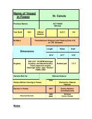
Fowey Estuary Management Plan Fowey Estuary ... - Fowey Harbour
Fowey Estuary Management Plan Fowey Estuary ... - Fowey Harbour
Fowey Estuary Management Plan Fowey Estuary ... - Fowey Harbour

You also want an ePaper? Increase the reach of your titles
YUMPU automatically turns print PDFs into web optimized ePapers that Google loves.
<strong>Fowey</strong> <strong>Estuary</strong> <strong>Management</strong> <strong>Plan</strong> Section 6<br />
March 2003 Landscape Conservation<br />
Section 6 Landscape Conservation<br />
Guiding Principle<br />
To protect and where possible enhance the unique natural<br />
beauty and distinctive landscape quality of the <strong>Fowey</strong><br />
<strong>Estuary</strong> for future generations, and to promote the<br />
conservation of the area’s natural assets by raising<br />
awareness of all estuary users of the value of those assets<br />
6.1 Promote wider understanding and recognition of<br />
landscape character and quality<br />
The <strong>Fowey</strong> ria or valley system, cut into slate, siltone and sandstone, was<br />
drowned after the last glaciation c10,000 BC by melt water which rose to<br />
shape its coast and creeks. The River <strong>Fowey</strong> rises on Bodmin Moor and<br />
flows for 36km in a southerly direction before reaching the tidal limits just<br />
above Lostwithiel. It then enters the estuary, and finally the English Channel.<br />
The estuary is approximately 11km in length, being 0.5km wide at the mouth<br />
and about 0.25km wide along the rest of its length. The River Lerryn is the<br />
main tributary and the main creeks are Pont Pill, Penpol and Mixtow.<br />
Its early deciduous woodland was probably cleared from the upper valley<br />
slopes and rounded hills as permanent settlements were established, from<br />
around 4000 BC. The resulting combination of semi-natural and managed<br />
land has created a landscape of variety and quality, much of which is covered<br />
by landscape designations. The <strong>Fowey</strong> ria is identified in the 1996 Cornwall<br />
Landscape Assessment as one of 45 areas of visual character in Cornwall.<br />
The <strong>Fowey</strong> <strong>Estuary</strong> is within an Area of Outstanding Natural Beauty (AONB),<br />
a statutory designation. The primary purpose of an AONB is to conserve<br />
natural beauty, but the need to safeguard agriculture, forestry and rural<br />
industries and the economic and social needs of the local communities is<br />
recognised. (AONB’s were designated by the Countryside Commission (now<br />
the Countryside Agency) under the National Parks & Access to countryside<br />
Act 1949. Legislation relating to AONB’s was updated within CROW Act<br />
2000.). An AONB partnership between Cornwall County Council and the<br />
relevant District Councils is in place and has a statutory obligation to produce<br />
a management plan by April 2004.<br />
The local Gribbin Head to Polperro coast is designated as Heritage Coast<br />
(HC). HC is non-statutory and applies to coast of exceptionally fine scenic<br />
quality exceeding 1 mile in length. (Most HC’s were defined in the 1980’s to<br />
early 1990’s by the Countryside Commission (now the Countryside Agency)).<br />
There is currently no HC management plan but policy protection is given in<br />
Page 19