

Moawhango Ecological District - Department of Conservation
Moawhango Ecological District - Department of Conservation
Moawhango Ecological District - Department of Conservation

You also want an ePaper? Increase the reach of your titles
YUMPU automatically turns print PDFs into web optimized ePapers that Google loves.
10 <strong>Moawhango</strong> <strong>Ecological</strong><br />
<strong>District</strong> - Tussock Country<br />
10.1 INTRODUCTION<br />
The <strong>Moawhango</strong> district is encircled by the Tongariro volcanoes in the west, by the<br />
North Island axial ranges in the north and east, and by the slump topography <strong>of</strong> the<br />
Rangitikei district in the south. <strong>Moawhango</strong> is a highly distinctive montane-subalpine<br />
area <strong>of</strong> the central North Island, with undulating and plateau topography. It has the<br />
North Island’s most extensive remaining red tussock grasslands, along with mixed<br />
shrublands, forests, wetlands and subalpine herbfields.<br />
People usually associate sweeping tussock landscapes with inland parts <strong>of</strong> the eastern<br />
South Island, but are unaware that tussocklands were also a major landscape feature<br />
when the early European explorers traversed the central North Island. Less than 10%<br />
<strong>of</strong> these tussocklands remain today. <strong>Moawhango</strong> district has the largest areas, and<br />
these are dominated by tall red tussock.<br />
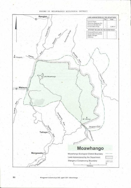
<strong>Moawhango</strong> <strong>Ecological</strong> <strong>District</strong> comprises 139,500 ha, <strong>of</strong> which about 96,300 ha lie in<br />
Wanganui Conservancy. The district is shown in Fig. 10, along with a description <strong>of</strong><br />
land administered by the <strong>Department</strong>.<br />
10.2 VISION<br />
The tussocklands and their associated native forests, shrublands and<br />
wetlands gain widespread recognition and respect for their special<br />
character and intrinsic values. The tussocklands’ natural character<br />
has improved. Contorta pine, heather, mouse-eared hawkweed and<br />
introduced animals are controlled and land development carefully<br />
managed so natural values and sweeping landscapes are conserved and<br />
not modified further.<br />
10.3 PHYSICAL DESCRIPTION<br />
10.3.1 Topography<br />
A sequence <strong>of</strong> geological events, some widely separated in time, and unparalleled<br />
elsewhere in New Zealand, produced the present landforms <strong>of</strong> the district. Greywacke<br />
is the old hard sandstone which forms the adjoining Kaimanawa, Kaweka and Ruahine<br />
Ranges. In this district it was uplifted, eroded, then partly submerged in an ancient sea<br />
which covered the present southern half <strong>of</strong> the North Island. A shoreline across the<br />
district marks the northern limit <strong>of</strong> the shallow seas in which s<strong>of</strong>t marine sediments<br />
(limestones, sandstones, mudstones) accumulated. Subsequent uplift <strong>of</strong> the land<br />
allowed erosion <strong>of</strong> the s<strong>of</strong>ter sediments, exposing the greywacke, mainly in the north.<br />
Greywacke surfaces which were not submerged in this sequence <strong>of</strong> events may be the<br />
oldest landforms in the North Island.<br />
Wanganui Conservancy CMS - April 1997 - <strong>Moawhango</strong><br />
87
A view eastwards from above<br />
the Desert Road takes in broad<br />
valleys and low ranges covered<br />
in native tussocks and forest<br />
remnants.<br />
Recent volcanic events to the west and north <strong>of</strong> the district covered it with layers <strong>of</strong><br />
tephra (aerially deposited volcanic material <strong>of</strong> all sizes from ash to coarse blocks). In<br />
the north there is also pumice from the Taupo eruption <strong>of</strong> about 180 AD. Pumice<br />
occurs as a layer in the tephra pr<strong>of</strong>ile or is redeposited as a result <strong>of</strong> water transport,<br />
in the floors <strong>of</strong> valleys and basins.<br />
10.3.2 Climate<br />
The district experiences a cool-temperate rain-shadow climate with moderate seasonal<br />
variations. Winds are predominantly from the west, although winds from the northeast<br />
are also important. A rain-shadow effect results from the surrounding mountains,<br />
especially the central volcanoes. The rainfall ranges from around 2000 mm per year in<br />
the mountains, to around 1000mm per year in the lower lying areas. The lowest<br />
recorded rainfall is 890mm at <strong>Moawhango</strong> village east <strong>of</strong> Hihitahi. Average summer<br />
temperatures are between 12-14 o C and the winter average is 4 o C. Frosts can occur in<br />
any month. Snow is common but seldom lies for more than a few days except for high<br />
south-facing parts <strong>of</strong> the New Zealand Defence Force training lands east <strong>of</strong> Waiouru.<br />
10.3.3 Water<br />
The upper <strong>Moawhango</strong> River flows across the district into Lake <strong>Moawhango</strong> which<br />
was created as an artificial lake for power generation as part <strong>of</strong> the Tongariro Power<br />
Development scheme. Water is also diverted into the lake from the Whangaehu<br />
catchment. Lake water is sent northwards via a tunnel to the Tongariro River in the<br />
Lake Taupo catchment.<br />
The Rangitikei River runs through the district in the east and the headwaters <strong>of</strong> the<br />
Hautapu River run through the south <strong>of</strong> the district.<br />
The Ohutu Stream, which flows <strong>of</strong>f and has a high waterfall near its confluence with<br />
the Whakaurekou River, is notable for the total absence <strong>of</strong> fish. 14<br />
10.3.4 Vegetation Patterns<br />
Much <strong>of</strong> the district has native vegetation, predominantly tussock grassland resulting<br />
from widespread Polynesian and European burning <strong>of</strong> the original forests. Today<br />
88 Wanganui Conservancy CMS - April 1997 - <strong>Moawhango</strong>
Cross Reference<br />
See Appendix 6<br />
Kaimanawa wild horses have<br />
inhabited the <strong>Moawhango</strong> since<br />
there is a mosaic <strong>of</strong> forest remnants, surrounded by the largest area <strong>of</strong> tussock<br />
grasslands in the North Island. Because <strong>of</strong> cold air inversion and poor drainage, there<br />
are a few sites which have been without trees for millennia. These sites support<br />
unusual habitats for a biogeographically special flora (see below).<br />
The district contains the Conservancy’s highest concentration <strong>of</strong> threatened and<br />
notable plant species.<br />
10.4 HISTORY<br />
the 1870s.<br />
The Hawkes Bay tribes, Ngati Whiti, Ngati Tama, Hinemanu and Te Upokoiri<br />
penetrated and occupied this country in earlier times. The Tuwharetoa people later<br />
intermarried with them. Tamatea Pokai Whenua visited the area with his son<br />
Kahungunu and left the three kaitiaki there: the lizard on , and the freshwater koura<br />
(crayfish) and the patiki (flounder) in the surrounding streams.<br />
An ancient Maori route around the headwaters <strong>of</strong> the Rangitikei River and its main<br />
tributaries, the <strong>Moawhango</strong> and Hautapu Rivers, was used for access between Hawkes<br />
Bay and inland Patea. 3 Prehistoric Maori settlement was concentrated at Te Awarua Pa<br />
situated above the Rangitikei River and at Matuku on the <strong>Moawhango</strong> River (both in the<br />
Rangitikei district). These kainga were visited by the early missionary explorers<br />
Richard Taylor from Wanganui in 1845 and William Colenso from Hawkes Bay in<br />
1847. 95 With increased European presence, these kainga were abandoned, and the<br />
present site <strong>of</strong> <strong>Moawhango</strong> village established in 1868.<br />
In November 1867, Captain Azim Birch travelled the central North Island in search <strong>of</strong><br />
land suitable for large scale sheep farming. He arranged a lease with the Maori owners<br />
<strong>of</strong> the 46,580 hectare Oruamatua-Kaimanawa Block located between the Rangitikei<br />
and <strong>Moawhango</strong> Rivers. Captain Birch and his brother William brought their first<br />
sheep, some 4,000 merinos, through the Kuripapango Track from Hawkes Bay in<br />
January 1868, and initiated the first European farming in the upper Rangitikei district. 3<br />
The Motukawa Block, on the western side <strong>of</strong> the <strong>Moawhango</strong> River was farmed in 1870<br />
by a partnership <strong>of</strong> Henare Kepa and Robert Thompson. 3<br />
Wanganui Conservancy CMS - April 1997 - <strong>Moawhango</strong><br />
Wild horses were first recorded in the Kaimanawa mountains in<br />
1876. These are likely to have been descendants <strong>of</strong> horses which<br />
came into the area with travellers, explorers, settlers, the military<br />
and Maori traders. In the 1870s Sir Donald McLean released sure<br />
footed horses known as the “Comet” breed on the Kaingaroa<br />
Plains and in later years this bloodline was reported in the wild<br />
population. Other horses contributed to the bloodline over the<br />
years. Horses from the mounted rifle cavalry units were released<br />
from Waiouru in 1941, and there have been escapes and releases<br />
from the sheep runs over the years.<br />
During the late 1970s the horse herd was hunted to near extinction, leading to<br />
protection <strong>of</strong> the remnant herd in 1981, through the Wildlife Act 1953. Subsequently<br />
the herd grew in size to approximately 2000 horses. A plan to reduce the impact <strong>of</strong><br />
horses on important ecological values has been prepared 26 . The protection provided<br />
to the horses was lifted in 1996. The current population shows highest genetic<br />
similarity to thoroughbred and thoroughbred cross types <strong>of</strong> breeds.<br />
89
10.5 VALUES AND THREATS<br />
Cross Reference<br />
See Sec 30.3(xi)<br />
See Sec. 20.1<br />
10.5.1 Background<br />
Much <strong>of</strong> the district’s natural character is the result <strong>of</strong> past human disturbance,<br />
especially the extensive tussock grasslands. Setting aside reserves is only part <strong>of</strong> the<br />
future conservation needs for the region. On-going management will be essential, and<br />
this may include the continuation <strong>of</strong> grazing in some places. Control <strong>of</strong> animal threats<br />
and weeds and, possibly, the selective use <strong>of</strong> fire are other aspects <strong>of</strong> conservation<br />
management.<br />
10.5.2 Protected Natural Areas Programme<br />
The entire district contains only four areas administered by the <strong>Department</strong> with<br />
formal protection, and only one <strong>of</strong> these, Hihitahi Sanctuary, is in Wanganui<br />
Conservancy. The four areas total 7344 ha, representing about 5% <strong>of</strong> the district’s land<br />
area. Of these four, the northwest corner <strong>of</strong> Ruahine Forest Park is in Hawkes Bay<br />
Conservancy, and two smaller areas are administered by Tongariro/Taupo<br />
Conservancy.<br />
The New Zealand Defence Force administers 30% <strong>of</strong> the district, and most <strong>of</strong> the<br />
remainder is in Maori ownership or owned privately.<br />
Because the areas administered by the <strong>Department</strong> do not adequately represent the full<br />
range <strong>of</strong> diversity in the district, a Protected Natural Areas Programme (PNAP) study<br />
was commissioned by the <strong>Department</strong> in 1992-93. 95<br />
The PNAP report identified nine Recommended Areas for Protection (RAPs) which<br />
represent most <strong>of</strong> the variety <strong>of</strong> natural areas remaining. These total some 16,000 ha<br />
which, if formally protected, would result in a little over 16% <strong>of</strong> the district having a<br />
protected status. Six <strong>of</strong> the RAPs lie in Wanganui Conservancy and three are in<br />
Hawkes Bay Conservancy.<br />
10.5.3 Ecosystem Diversity<br />
(a) Forest<br />
The present pattern <strong>of</strong> patches <strong>of</strong> native forest is the result <strong>of</strong> fragmentation <strong>of</strong> the<br />
original forest cover by fires. Some fires occurred before a human presence in the area,<br />
but the extensive conversion <strong>of</strong> forest to tussock grassland coincided with Polynesian<br />
settlement, and was extended by European farming methods.<br />
There are three broad forest types remaining, namely kaikawaka (or native cedar)<br />
forest, beech forest and podocarp/broad-leaved forest. The patchy distribution<br />
patterns <strong>of</strong> forest tree species are important in constructing models <strong>of</strong> past and future<br />
vegetation <strong>of</strong> the district. Areas <strong>of</strong> forest on land administered by the New Zealand<br />
Defence Force and the block are among the most important for such studies.<br />
Kaikawaka is well-represented in Hihitahi Sanctuary and the block, with smaller<br />
fragments on other, mostly elevated, plateau surfaces.<br />
Beeches, especially mountain beech, form the most extensive forests and are generally<br />
regenerating. Beech is spreading outwards from forest margins and into some<br />
90 Wanganui Conservancy CMS - April 1997 - <strong>Moawhango</strong>
kaikawaka and podocarp/broad-leaved forest.<br />
The dominant species <strong>of</strong> podocarp on a given site depends on many factors, including<br />
the history <strong>of</strong> site disturbance. Pink pine, Hall’s totara and mountain toatoa are<br />
common at high altitudes, <strong>of</strong>ten mixed with kaikawaka or beeches. The north-west<br />
part <strong>of</strong> Ruahine Forest Park and adjoining Maori land towards contain good<br />
examples. Places with more fertile soils and a milder climate have kahikatea, rimu,<br />
totara and matai. has extensive and intact examples on its lower slopes.<br />
Forest areas provide habitat for a number <strong>of</strong> common forest bird species such as<br />
tomtit, fantail, grey warbler, whitehead and bellbird along with uncommon species<br />
such as falcon, kaka, and kiwi.<br />
High numbers <strong>of</strong> deer and possums in the past have significantly altered the<br />
composition <strong>of</strong> the forests <strong>of</strong> Hihitahi Forest Sanctuary. The higher altitude<br />
component <strong>of</strong> this forest has been under considerable stress with up to 50% <strong>of</strong> the<br />
dominant emergents, kaikawaka and totara, dead or dying with little regeneration.<br />
Recent evidence suggests that significant possum damage to kaikawaka is occurring<br />
and may have been a factor in the past. Beneath the emergents, a fragmented canopy<br />
occurs over a dense understorey <strong>of</strong> horopito and other unpalatable plants.<br />
The extensive beech forests <strong>of</strong> the district are themselves probably little affected by<br />
introduced animals, though palatable components <strong>of</strong> the understorey will have been<br />
removed and sometimes replaced by less palatable species. A red-flowered mistletoe,<br />
which was probably widespread in the past, has been reduced to a few sites because <strong>of</strong><br />
possum browsing.<br />
(b) Shrublands<br />
Areas <strong>of</strong> tussock grassland, which are protected from periodic fire, eventually revert to<br />
forest through stages <strong>of</strong> regenerating shrubs. Most tussock grasslands would give way<br />
to native shrublands within 30-65 years, in the absence <strong>of</strong> fire. Monoao, a native heath,<br />
is the prominent colonising shrub in the northern half <strong>of</strong> the district, to be replaced by<br />
a related shrub, inaka, in the southern half. Other native heaths and small-leaved<br />
species <strong>of</strong> Hebe, Coprosma, Pittosporum and other shrubs are common, and manuka<br />
is locally dominant on slopes where cold air can flow away, such as parts <strong>of</strong> the New<br />
Zealand Defence Force training lands east <strong>of</strong> Waiouru.<br />
Wet sites occasionally have bog pine or, at lower altitudes, the shrub daisy, Olearia<br />
virgata. The latter is prominent in the small parts <strong>of</strong> Kutaroa and Otahupitara<br />
Swamps (RAP 9) 95 (called "Irirangi Swamp" in the <strong>Moawhango</strong> PNAP report) which<br />
have escaped fire for several decades.<br />
Among the unusual shrubs <strong>of</strong> cliff habitats are the grey-leaved Hebe colensoi which is<br />
endemic to this district and inland Hawke’s Bay. A sprawling shrub with grey furry<br />
leaves, Pimelea aridula is confined to four widely separated sites in the North Island,<br />
one being a small part <strong>of</strong> the New Zealand Defence Force Military Training Area.<br />
Small passerine birds such as silvereye, fantail and introduced finches inhabit<br />
shrublands. Fernbirds are very local, and other species such as bellbird use shrublands<br />
seasonally.<br />
(c) Tussock grasslands<br />
Above all else, it is the tussock grasslands which define the character <strong>of</strong> <strong>Moawhango</strong><br />
Wanganui Conservancy CMS - April 1997 - <strong>Moawhango</strong><br />
91
The Makirikiri Tarns are part <strong>of</strong><br />
the botanically rich wetlands <strong>of</strong><br />
the <strong>Moawhango</strong> Plateau.<br />
Cross Reference<br />
See Sec 10.5.6<br />
<strong>Ecological</strong> district. Tall red tussock is the most prominent species on previously burnt<br />
sites with moderate to good drainage and deep soils. Shorter stature silver tussock<br />
thrives on high fertility sites, and hard tussock is most common on cold arid sites, such<br />
as pumice or gravel in valley floors. Cushions <strong>of</strong> bristle tussock colonise sandy areas.<br />
Tussock-forming sedges occur in wetter sites, especially Schoenus pauciflorus which<br />
grows with red tussock on wetland edges, and the large Carex secta grows with<br />
harakeke in some <strong>of</strong> the lower altitude wetlands.<br />
To keep tussocks over much <strong>of</strong> the district, periodic fires will be required. Heather,<br />
Pinus contorta, and mouse-eared hawkweed are potentially serious invaders <strong>of</strong><br />
tussock grasslands. Recurrent fires and browsing mammals aid the establishment and<br />
spread <strong>of</strong> such weeds. If decisions are made to maintain tussock landscapes, there will<br />
be an ongoing need for weed control.<br />
Common skink and common gecko seem to be widespread in stony places in tussock<br />
grasslands. New Zealand pipits and harriers are common and falcons are <strong>of</strong>ten seen.<br />
Falcons nest on cliffs in the region’s river gorges and a mixed colony <strong>of</strong> black and little<br />
shags is known on cliffs <strong>of</strong> the upper <strong>Moawhango</strong> River. Introduced passerines are<br />
common, and include finches, hedgesparrow and skylark. Banded dotterels breed in<br />
several remote open areas. A nesting colony <strong>of</strong> black-backed gulls is on .<br />
Grazing by farm stock and feral horses has been a major factor in modifying the<br />
grasslands since the 1880s, though intermittent burning has also affected them.<br />
Tussock grasslands have been modified from tall tussock to short tussock, particularly<br />
on sheltered basin floors and warm plateaux favoured by stock. Several species may<br />
have largely disappeared including the palatable and once widespread blue wheat<br />
grass which disappeared early from tussock grasslands with the arrival <strong>of</strong> stock.<br />
(d) Wetlands<br />
Broad valley floors, ridge crests and elevated plateaux are <strong>of</strong>ten places where water<br />
lies. The water may be ephemeral, as in the , or permanent, in which case peat<br />
accumulates. The accumulation <strong>of</strong> tephra or pumice has <strong>of</strong>ten accentuated the effects<br />
<strong>of</strong> flat terrain and produced some large wetlands. Among the notable ones still in a<br />
relatively natural state are the <strong>Moawhango</strong> headwaters above gorge, the eastern<br />
surfaces.<br />
92 Wanganui Conservancy CMS - April 1997 - <strong>Moawhango</strong><br />
Ngamatea Swamp, the Kutaroa and Otahupitara<br />
Swamps 70 southwest <strong>of</strong> Waiouru and, on the<br />
Mangaohane Plateau, the Reporoa Bog and Makirikiri<br />
Tarns, all <strong>of</strong> which are recommended areas for<br />
protection 95 (RAPs).<br />
Wetlands such as these are some <strong>of</strong> the oldest non-<br />
forested places in the district, and they are botanically<br />
very important for having a number <strong>of</strong> open country<br />
native plants which are unknown elsewhere in the North<br />
Island. 27,95 These species give support to the views<br />
expressed above about the presence <strong>of</strong> ancient land<br />
Paradise shelduck, pied stilt, black shag and little shag are typical wetland species <strong>of</strong><br />
this district. More localised are banded dotterel, blue duck, and fernbird. Information<br />
on native fish in this area is scarce.<br />
Of all habitats in the district, wetlands are probably the most vulnerable to damage
from domestic stock and wild animals. As a source <strong>of</strong> water and, sometimes, highly<br />
nutritious plants, wetlands are <strong>of</strong>ten a focus for animals resulting in both severe<br />
grazing and pugging. Wetlands are lost through drainage for pasture improvement.<br />
10.5.4 Water<br />
The <strong>Moawhango</strong> River above Lake <strong>Moawhango</strong> is unmodified and has high natural<br />
values, although the movement <strong>of</strong> fish from the lower river is prevented by the<br />
<strong>Moawhango</strong> dam. The Rangitikei River is protected by a National Water <strong>Conservation</strong><br />
Order (1993) above the Mangarere Bridge. The Hautapu River is protected by a Local<br />
Water <strong>Conservation</strong> Order (1990) above its confluence with the Oraukura Stream.<br />
The flow <strong>of</strong> the <strong>Moawhango</strong> River above the dam is diverted to the Tongariro River as<br />
part <strong>of</strong> the Tongariro Power Development Scheme. This has resulted in very low river<br />
flows below the dam, substantially reducing the river’s aquatic habitat, fisheries, and<br />
wild and scenic values.<br />
10.5.5 Landscape<br />
Tussock grasslands are part <strong>of</strong> the cultural identity <strong>of</strong> many New Zealanders, to whom<br />
they are parts <strong>of</strong> primeval New Zealand. The district’s tussock grasslands are largely<br />
the result <strong>of</strong> repeated fires. If protected from fire, native shrubs and eventually forest<br />
will take their place. Ploughing and re-sowing <strong>of</strong> pasture plants has been a major cause<br />
<strong>of</strong> the recent decline in the extent <strong>of</strong> tussocklands in the district. About 87% <strong>of</strong> North<br />
Island's tussock grasslands lie in the <strong>Moawhango</strong> district 95 . Beyond the district, many<br />
tussock grasslands were lost to exotic forestry, and this is now a potentially serious<br />
threat to landscapes in the <strong>Moawhango</strong> district. The spread <strong>of</strong> wilding pines is one<br />
extension <strong>of</strong> this threat. Heather, which has already obliterated most <strong>of</strong> the low<br />
altitude tussock landscapes in Tongariro National Park, is a relatively new arrival in the<br />
western parts <strong>of</strong> the <strong>Moawhango</strong> district.<br />
It is no accident that some <strong>of</strong> the best remaining tussock grasslands are where stock<br />
numbers are low or absent, for example the New Zealand Defence Force Military<br />
Training Area at Waiouru and the block on the Mangaohane Plateau.<br />
Protection <strong>of</strong> tussocklands, the most distinctive landscape feature <strong>of</strong> the <strong>Moawhango</strong><br />
district, will not be easy to achieve. Formal protection <strong>of</strong> such areas has its part, but the<br />
tussock landscape as a whole can only survive with a commitment <strong>of</strong> landowners to a<br />
sustainable management regime, which will need to include the deliberate use <strong>of</strong> fire.<br />
In stressing the values <strong>of</strong> tussock landscapes, it should be remembered that the<br />
district’s other landscapes include some <strong>of</strong> the Conservancy’s most dramatic<br />
landforms. These include the rugged greywacke gorges, sandstone and limestone<br />
plateaux, scarps and river cliffs, and broad tussock basins traversed by meandering<br />
rivers. The scattered native forest remnants <strong>of</strong> the district are <strong>of</strong> great visual<br />
importance as they give a scale to the landforms, and they punctuate not only the<br />
tussock grasslands but also the areas converted to pasture.<br />
The low incidence <strong>of</strong> artificial structures in the district adds to the sweeping,<br />
uncluttered nature <strong>of</strong> the district’s landscapes. The existing buildings, fences, and<br />
roads are mostly unobtrusive, although a clutter <strong>of</strong> small buildings, visible from State<br />
Highway No.1 between Waiouru and Hihitahi, the <strong>Moawhango</strong> dam, and high voltage<br />
transmission lines are exceptions. Future developments need to be sympathetic to<br />
landscape quality.<br />
Wanganui Conservancy CMS - April 1997 - <strong>Moawhango</strong><br />
93
Cross Reference<br />
See Appendix 6<br />
Small-scaled skinks occur in<br />
rocky areas in farmlands <strong>of</strong> the<br />
Upper Rangitikei River.<br />
10.5.6 Plants at Risk<br />
<strong>Moawhango</strong> district has 18 species featuring in the national list <strong>of</strong> threatened, rare and<br />
local plants. Of the various habitats described above, it is the wetlands, including<br />
ephemeral wetlands, which have the highest concentrations <strong>of</strong> species in this list.<br />
A wetland herb, Logania depressa, is considered nationally extinct as it has not been<br />
seen since William Colenso found it in 1847. The district’s plants which are ranked as<br />
the most threatened nationally are also wetland species. They are a bidibid, , and a<br />
grass . The bidibid has its only New Zealand location in the Makirikiri basin on the<br />
Mangaohane Plateau. It seems to be most threatened by the spread <strong>of</strong> the introduced<br />
Hieracium. Amphibromus occurs in one tarn on land administered by the New<br />
Zealand Defence Force where it is subject to feral horse damage. Likewise, a tussock<br />
grass, Deschampsia caespitosa, recorded from three locations in the district, may<br />
have been eliminated by horse and stock grazing. Basins in the <strong>Moawhango</strong> River<br />
headwaters are an important site for a number <strong>of</strong> small herbs. They include two<br />
threatened species <strong>of</strong> forget-me-nots (Myosotis) and a small buttercup Ranunculus<br />
recens. Another buttercup, Ranunculus ternatifolius, is recorded from the Reporoa<br />
Bog on the Mangaohane Plateau, one <strong>of</strong> only two North Island sites for the species.<br />
This plateau is also the highest altitude site for the tree Pittosporum turneri, a central<br />
North Island endemic species.<br />
The Kutaroa and Otahupitara wetlands, southwest <strong>of</strong> Waiouru have a number <strong>of</strong><br />
uncommon wetland plants, including what is probably the largest New Zealand<br />
population <strong>of</strong> an un-named Prasophyllum orchid. 70<br />
The mistletoe Peraxilla tetrapetala is known from a small area <strong>of</strong> mountain beech<br />
forest on land administered by the New Zealand Defence Force. It is likely this species<br />
has been severely depleted by possum browsing.<br />
10.5.7 Wildlife at Risk<br />
Kiwi, blue duck, falcon, banded dotterel, fernbird, harrier and kaka are threatened bird<br />
species that occur in the district. Kiwi have been recorded in the Hihitahi Sanctuary,<br />
and there are unconfirmed reports from the north-west Ruahine Range, just south <strong>of</strong><br />
the Conservancy boundary.<br />
Blue duck have been recorded in the Otokoro Stream and adjoining parts <strong>of</strong> the<br />
<strong>Moawhango</strong> River and also in the Mangatera Stream and tributaries. Basins <strong>of</strong> the<br />
Upper <strong>Moawhango</strong> River and Ngamatea East swamp are nesting habitats for banded<br />
dotterel. New Zealand falcon are seen widely and kaka have been reported from a<br />
number <strong>of</strong> localities. Fernbird are known from shrublands on Kutaroa swamp and<br />
near the .<br />
94 Wanganui Conservancy CMS - April 1997 - <strong>Moawhango</strong><br />
One <strong>of</strong> the Conservancy's most threatened<br />
lizards is found in this district. Until recently,<br />
small-scaled skink were known from only 11<br />
sites in the district and on Motutaiko Island on<br />
Lake Taupo. Recent surveys have increased our<br />
knowledge <strong>of</strong> the distribution and range <strong>of</strong> the<br />
species through to the Upper Mohaka<br />
catchment, east <strong>of</strong> Taupo.<br />
In the <strong>Moawhango</strong> <strong>District</strong>, small-scaled skink<br />
occur predominantly on eroding river terraces
Cross Reference<br />
See Sec. 37.4<br />
and exposed rock slides in developed pasture. A conservation strategy has been<br />
prepared for the protection <strong>of</strong> this species 46 . The key elements <strong>of</strong> this strategy include:<br />
• the survey <strong>of</strong> potential areas <strong>of</strong> habitat identified by Whitaker (1993)<br />
• the monitoring <strong>of</strong> selected populations<br />
• the assessment <strong>of</strong> impacts resulting from grazing and predators.<br />
Powelliphanta marchanti, a nationally rare large land snail, is known from the<br />
Mangaohane Plateau and the Rangitikei River headwaters.<br />
10.5.8 Historic Places<br />
No historic places are known on land administered by the <strong>Department</strong> within this<br />
district.<br />
10.5.9 Recreation<br />
Hihitahi Forest Sanctuary is used mainly for recreational hunting. It is one <strong>of</strong> the few<br />
areas in the Conservancy with red deer and is popular during the 'roar' hunting<br />
season. Tramping clubs also use the area for day trips. A track provides access into<br />
the sanctuary from State Highway No.1 and a basic hut <strong>of</strong>fers shelter. Recreational<br />
hunters sometimes request permission to fly into the area by helicopter, especially<br />
during the 'roar'. Aerial access would encourage recreational hunting and is unlikely to<br />
have a significant impact on other users.<br />
The Military Training Area is a significant area <strong>of</strong> backcountry with potential for<br />
recreation. Use <strong>of</strong> the area, however, is restricted by the Defence Act 1990. The<br />
<strong>Department</strong> runs trips into the area as part <strong>of</strong> its summer nature programme to view<br />
the tussocklands and Kaimanawa wild horses. These trips assist, to some degree, in<br />
opening the area to the public and enhancing public understanding <strong>of</strong> the need to<br />
manage the horse population.<br />
The Rangitikei portion <strong>of</strong> the Inland Patea Heritage Trail passes through the district.<br />
The trail, linking Taihape with Hastings, highlights places <strong>of</strong> scenic and historic<br />
significance on the touring route.<br />
10.5.10 Commercial (Non-Recreation) Activity<br />
There are no known commercial activities on land administered by the <strong>Department</strong> in<br />
this district.<br />
10.5.11 Public Awareness<br />
Because much <strong>of</strong> the district’s native vegetation is in private or Maori ownership,<br />
public awareness will target protection <strong>of</strong> important sites. In particular, the PNAP<br />
survey <strong>of</strong> the district showed the desirability <strong>of</strong> protecting the Kutaroa and<br />
Otahupitara Swamp and the block in the north-west corner <strong>of</strong> the Ruahine Ranges.<br />
Public support for programmes to combat infestations <strong>of</strong> heather and Pinus contorta<br />
will be important for the success <strong>of</strong> control efforts in the district.<br />
Public awareness will aim to increase understanding <strong>of</strong> the damage the wild horses do<br />
to the fragile environment they live in, and to gain support for the herd management<br />
plan.<br />
Wanganui Conservancy CMS - April 1997 - <strong>Moawhango</strong><br />
95
10.6 CHECKLIST OF KEY ISSUES<br />
• Need for formal protection <strong>of</strong> land with high natural values.<br />
• Continuing losses and degradation <strong>of</strong> tussock grasslands, wetlands and forest<br />
remnants.<br />
• Need for protection and future management <strong>of</strong> the block.<br />
• Improve consultation with Tangata Whenua.<br />
• Degradation <strong>of</strong> small-scaled skink habitat in farmlands.<br />
• Impacts <strong>of</strong> military training activities and protection <strong>of</strong> tussocklands.<br />
• Threats to the continued survival <strong>of</strong> many nationally threatened plants and<br />
biogeographically special plants.<br />
• Conflicts between nature/landscape conservation and the protection <strong>of</strong> wild<br />
horses.<br />
• Management <strong>of</strong> the wild horse herd, and public awareness <strong>of</strong> the issues involved.<br />
• Weed invasion, especially heather, Pinus contorta, mouse-eared hawkweed.<br />
• Promotion <strong>of</strong> the use <strong>of</strong> volunteers for weed control.<br />
• Fire management to maintain ecosystem naturalness.<br />
• The use <strong>of</strong> aerial access for recreational hunting in the Hihitahi Sanctuary.<br />
• Retaining high natural values <strong>of</strong> waterbodies.<br />
• Impacts <strong>of</strong> low flows in the <strong>Moawhango</strong> River.<br />
• Management <strong>of</strong> possum and deer threat to ensure continuance <strong>of</strong> Kaikawaka and<br />
Hall's totara forest.<br />
10.7 MANAGEMENT OBJECTIVES<br />
10.7.1 Land Management<br />
Legal Protection <strong>of</strong> Land<br />
(i) To seek as a priority, the protection <strong>of</strong> significant natural areas in the<br />
tussocklands as identified in the PNAP report and other natural resource<br />
inventories, primarily through:<br />
96 Wanganui Conservancy CMS - April 1997 - <strong>Moawhango</strong><br />
• working with landowners to achieve legal and physical protection <strong>of</strong><br />
the six areas recommended for protection by the <strong>Moawhango</strong> PNAP<br />
• working with the New Zealand Defence Force to protect four RAPs<br />
located within the military training area<br />
• advocating the protection <strong>of</strong> natural areas in regional and district plans<br />
and on resource consent applications<br />
• increasing public awareness <strong>of</strong> and support for protection <strong>of</strong> areas<br />
identified through PNAP.
(ii) To promote protection <strong>of</strong> the natural values <strong>of</strong> the block<br />
by encouraging the multiple owners to protect this area to maintain its<br />
natural character.<br />
(iii) To seek as a priority the protection <strong>of</strong> wetlands, particularly Kutaroa and<br />
Otahupitara Swamps, which are in their natural state.<br />
10.7.2 Kaupapa Atawhai<br />
Swamps<br />
(i) To work with Tangata Whenua so that they are informed about the natural<br />
and historic values that exist on their land by:<br />
• exchange <strong>of</strong> information that relates to the special natural values <strong>of</strong><br />
land such as the block and Kutaroa and Otahupitara<br />
• raising the awareness <strong>of</strong> Maori land owners <strong>of</strong> the natural values <strong>of</strong><br />
their land<br />
• promoting the importance <strong>of</strong> co-operation which would enable<br />
resources to be used in a sustainable way<br />
• encouraging the preservation and protection <strong>of</strong> nominated sites which<br />
have cultural significance<br />
• encouraging hui which promote the cultural integrity <strong>of</strong> landscapes.<br />
10.7.3 Landscape<br />
(i) Promote retention <strong>of</strong> the district’s extensive natural character and<br />
landscapes, particularly the tussockland and , by working with<br />
landowners and local authorities to ensure that land uses are sustainable<br />
and sensitive to the special character <strong>of</strong> the district.<br />
10.7.4 Native Species Protection<br />
(i) Implement the <strong>Conservation</strong> Strategy for small-scaled skink through:<br />
• surveying potential areas <strong>of</strong> habitat <strong>of</strong> the species<br />
• monitoring selected populations<br />
• assessing the impacts <strong>of</strong> grazing and predators on the species.<br />
(ii) Seek protection, in conjunction with the New Zealand Defence Force, <strong>of</strong><br />
the unique assemblage <strong>of</strong> nationally threatened and biogeographically<br />
special plants in the <strong>Moawhango</strong> headwaters through:<br />
• ongoing monitoring to determine changes in status and nature <strong>of</strong><br />
threats<br />
• control <strong>of</strong> invasive weed species, especially Pinus contorta, mouse<br />
eared hawkweed and heather, including seed sources in adjoining<br />
districts<br />
• reducing the impact <strong>of</strong> wild horses at key sites.<br />
(iii) Where necessary and practicable, control animal threats and predators <strong>of</strong><br />
native species in accordance with national or local species recovery plans.<br />
Wanganui Conservancy CMS - April 1997 - <strong>Moawhango</strong><br />
97
10.7.5 Threats<br />
(i) To advocate the control <strong>of</strong> weeds, especially heather, mouse-eared<br />
hawkweed and Pinus contorta, in areas <strong>of</strong> high ecological value.<br />
(ii) Encourage public involvement in weed control programmes.<br />
(iii) To control the possum population in Hihitahi Sanctuary to a level that does<br />
not impact on the survival <strong>of</strong> remaining kaikawaka and Hall's totara.<br />
(iv) Monitor the deer population density and impact in Hihitahi Sanctuary and<br />
98 Wanganui Conservancy CMS - April 1997 - <strong>Moawhango</strong><br />
introduce control measures if required to maintain regeneration and<br />
survival <strong>of</strong> key forest elements.<br />
10.7.6 Wild Horses<br />
(i) Manage the wild horse population in terms <strong>of</strong> the Kaimanawa Wild Horse<br />
Plan 26 to protect important landscape,ecological and botanical values<br />
through:<br />
• the removal <strong>of</strong> horses from priority areas, such as the Ngawakaakauae<br />
sector identified in the plan<br />
• support <strong>of</strong> a viable horse population in areas <strong>of</strong> low ecological value<br />
• monitoring ‘at risk’ values to assist in determining future management<br />
• public awareness <strong>of</strong> the issues involved.<br />
(ii) Maintain a low risk to State Highway No.1 traffic by the continued<br />
reduction <strong>of</strong> horse numbers close to the highway.<br />
10.7.7 Fire<br />
(i) Consult with affected parties and develop protocols and methods for the<br />
use <strong>of</strong> fire as a management tool in tussock grasslands.<br />
10.7.8 Recreation<br />
(i) Subject to the preservation <strong>of</strong> natural and historic resources <strong>of</strong> the area,<br />
recreational opportunities will be enhanced through:<br />
• managing recreational hunting and tramping opportunities in Hihitahi<br />
Sanctuary<br />
• allowing aerial access for recreational hunters to designated landing<br />
sites (Zeke’s Hut and Tar Paper Hut) in Hihitahi Sanctuary, including<br />
the issuing <strong>of</strong> commercial helicopter transport concessions<br />
• liaising with the New Zealand Defence Force to encourage continued<br />
controlled public access to the land it administers, while recognising<br />
that the Defence Act 1990 restricts public access<br />
• advocating protection <strong>of</strong> open spaces and other scenic values along the<br />
Inland Patea Heritage Trail, the Rangitikei River and elsewhere in the<br />
district.
10.7.9 Freshwater<br />
(i) Promote the maintenance <strong>of</strong> the high natural values <strong>of</strong> the district’s<br />
waterbodies.<br />
(ii) Promote protection <strong>of</strong> the instream values <strong>of</strong> the <strong>Moawhango</strong> River<br />
through river flows which safeguard life supporting capacity <strong>of</strong> the river.<br />
(iii) Advocate the ongoing protection <strong>of</strong> the Rangitikei River and its upper<br />
tributaries.<br />
(iv) Priority will be given to maintaining natural vegetation cover in the<br />
catchments <strong>of</strong> this district.<br />
(v) Achieve greater protection for wetlands identified as RAPs in the<br />
<strong>Moawhango</strong> PNAP report.<br />
10.7.10 Cross Boundary Issues<br />
(i) To liaise with adjacent conservancies on cross-boundary issues such as<br />
fire control, wild horse management, Pinus contorta control and natural<br />
area protection.<br />
Wanganui Conservancy CMS - April 1997 - <strong>Moawhango</strong><br />
99


