Fen Management Handbook - Scottish Natural Heritage
Fen Management Handbook - Scottish Natural Heritage
Fen Management Handbook - Scottish Natural Heritage

Create successful ePaper yourself
Turn your PDF publications into a flip-book with our unique Google optimized e-Paper software.
The <strong>Fen</strong> <strong>Management</strong> <strong>Handbook</strong><br />
Edited by Andrew McBride,<br />
Iain Diack, Nick Droy,<br />
Bobbie Hamill, Peter Jones,<br />
Johan Schutten, Ann Skinner<br />
and Margaret Street
The <strong>Fen</strong> <strong>Management</strong> <strong>Handbook</strong><br />
Edited by Andrew McBride,<br />
Iain Diack, Nick Droy,<br />
Bobbie Hamill, Peter Jones,<br />
Johan Schutten, Ann Skinner<br />
and Margaret Street
Acknowledgements<br />
Production of the <strong>Fen</strong> <strong>Management</strong> <strong>Handbook</strong> has been co-ordinated by an<br />
editorial steering group comprising (in alphabetical order) Iain Diack, Senior<br />
Wetland Specialist at <strong>Natural</strong> England (NE); Nick Droy, Wetlands Adviser for<br />
Royal Society for Protection of Birds (RSPB); Bobbie Hamill, Northern Ireland<br />
Environment Agency (NIEA); Pete Jones, Peatland Ecologist for the Countryside<br />
Council for Wales (CCW); Hans Schutten, Senior Wetlands Adviser for <strong>Scottish</strong><br />
Environment Protection Agency (SEPA); Ann Skinner, National Conservation Policy<br />
Adviser for the Environment Agency (EA) and Margaret Street, Wetland Specialist<br />
for NE. Andrew McBride, Wetland Ecologist for <strong>Scottish</strong> <strong>Natural</strong> <strong>Heritage</strong> (SNH)<br />
chaired the steering group. Vyv Wood-Gee, freelance Countryside <strong>Management</strong><br />
Consultant, was contracted to edit the draft text.<br />
The Editorial Group and Vyv Wood-Gee have produced the text from that provided<br />
by the following lead authors who we gratefully acknowledge for their contribution;<br />
Roger Meade, Rob Low, Alistair Headley, Richard Robinson and Sarah Ross.<br />
The Editorial Board would also like to acknowledge the help given in Peer review by<br />
Dr Sue Shaw, Dr Brian Wheeler, Andrew Panter, Nick Haycock, Craig MacAdam,<br />
Alistair Headley and Alan Stubbs. Special thanks to Andrea Kelly and her team<br />
at the Broads Authority (particularly Sue Stephenson) for their comments and<br />
guidance on the handbook.<br />
In addition, we would like to acknowledge the contribution<br />
from the following people;<br />
Becky Barrett, Matt Fasham, Max Wade, Rob Pitcher, Robin Ward, Roger Buisson,<br />
Simon Jones, Edwin Lomas, Sam Bosanquet, Gerard Hawley, Matt Sutton, Jacky<br />
Carrol, Andrew Excell and Jim Jeffrey.<br />
Sections 6, 7 and 9 <strong>Fen</strong> Vegetation, Water <strong>Management</strong> and <strong>Fen</strong> Creation – the<br />
assistance of Sandie Tolhurst and the Broads Authority in making the text of their<br />
publications freely available is gratefully acknowledged. Thanks are also due to<br />
Simon Weymouth of the Forestry Commission (FC) who has provided text from the<br />
New Forest <strong>Management</strong> guidelines, and Rick Southwood of <strong>Natural</strong> England for<br />
the benefit of his experience in managing Woodbastwick National Nature Reserve,<br />
and Tim Coleshaw of <strong>Natural</strong> England for the Wybunbury Moss case study.<br />
Section 11 <strong>Fen</strong>s and People – Sarah Eno, Chris Soans, Tim Strudwick, Andrea<br />
Kelly, Matt Bradbury, George Taylor, John Blackburn, Steve Hughes, Tom Hill, Mike<br />
Page, Jane Stevens, Helen Smith and Stuart Warrington very generously provided<br />
information or images and commented on drafts of this section.<br />
Diagrams were drawn by Craig Ellery of Ellery Design, Edinburgh.<br />
Design and typeset by River Design, Edinburgh<br />
Citation<br />
For bibliographic purposes this book should be referred to as The <strong>Fen</strong> <strong>Management</strong><br />
<strong>Handbook</strong>, (2011), Editors A. McBride, I. Diack, N Droy, B. Hamill, P.Jones, J. Schutten,<br />
A. Skinner, and M. Street. <strong>Scottish</strong> <strong>Natural</strong> <strong>Heritage</strong>, Perth.
Contents<br />
1. Introduction and Basic Principles ________________________________________7<br />
2. <strong>Fen</strong> Flora and Fauna ___________________________________________________14<br />
3. Understanding <strong>Fen</strong> Hydrology ___________________________________________39<br />
4. Understanding <strong>Fen</strong> Nutrients ____________________________________________57<br />
5. <strong>Fen</strong> <strong>Management</strong> and Restoration _______________________________________76<br />
6. <strong>Fen</strong> Vegetation <strong>Management</strong> ____________________________________________101<br />
7. <strong>Fen</strong> Water <strong>Management</strong> ________________________________________________144<br />
8. Managing <strong>Fen</strong> Nutrient Enrichment _______________________________________171<br />
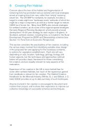
9. Creating <strong>Fen</strong> Habitat __________________________________________________186<br />
10. Monitoring to Inform <strong>Fen</strong> <strong>Management</strong> ____________________________________212<br />
11. <strong>Fen</strong>s and People ______________________________________________________240<br />
12. <strong>Fen</strong>s From an Economic Perspective _____________________________________259<br />
Appendix I Glossary __________________________________________________273<br />
Appendix II List of Acronyms Used in the <strong>Handbook</strong> _______________________275<br />
Appendix III Common And Scientific Names of Species Referred to in Text _____276<br />
Appendix IV NVC Classifications for <strong>Fen</strong> Habitats __________________________287<br />
Appendix V Legal and Regulatory Requirements for Wetland Projects _________296<br />
Appendix VI <strong>Fen</strong> <strong>Management</strong> for Bryophytes______________________________300<br />
Appendix VII <strong>Fen</strong> <strong>Management</strong> for Vertebrates _____________________________303<br />
Appendix VIII <strong>Fen</strong> Managment for Invertebrates _____________________________312<br />
Appendix IX Further Reading ____________________________________________322<br />
Index _________________________________________________________330<br />
5
1. Introduction and Basic Principles<br />
<strong>Fen</strong>s are magical places; they are an essential part of our<br />
cherished landscape. They support a rich variety of wildlife, and<br />
are often a repository of evidence of many generations of past<br />
economic use and management. With so much in their favour, it is<br />
perhaps surprising that fens are one of the least well recognised<br />
habitats, and a part of our countryside which most people<br />
understand little about.<br />
This handbook has been produced to improve understanding<br />
of fens and how they function, to explain why fens need<br />
management and to provide best practice guidance. Case<br />
studies are included at the end of most sections as practical<br />
examples of the principles and techniques outlined in the text.<br />
The handbook is aimed at anyone interested in fens, or who might<br />
become involved in fen management, creation or restoration from<br />
a practical, policy or planning perspective.<br />
Key points and good practice are highlighted in green boxes.<br />
Cautions about activities which might be legislatively controlled<br />
or which might potentially damage the interest of fens are<br />
highlighted in red boxes. Snapshot case studies in the text to<br />
illustrate specific points are highlighted in yellow.<br />
1.1 What are fens?<br />
The word ‘fen’ is derived from the old English word ‘fenn’ meaning<br />
marsh, dirt or mud.<br />
A fen is a wetland that receives water and nutrients from surface and/or<br />
groundwater, as well as from rainfall.<br />
Differentiating between fens and bogs<br />
<strong>Fen</strong>s receive most of their water via rock and soil which contain<br />
dissolved minerals creating growing conditions that allow more lush<br />
vegetation than bogs.<br />
Bogs receive water exclusively from rainfall which is acidic and contains<br />
very few minerals; consequently rain-fed acid bogs support a less<br />
diverse range of vegetation than fens.<br />
<strong>Fen</strong>s are found from sea level up into the hills, across the whole of the British<br />
Isles. They range in size from tiny flushes of only a few square metres, to extensive<br />
floodplain fens covering hundreds of hectares, forming important features in the<br />
wider landscape and river catchments.<br />
7
Map showing an indicative<br />
distribution of lowland<br />
fens in the UK (JNCC)<br />
1.2 What’s so special about fens?<br />
<strong>Fen</strong>s were prized by our ancestors for the range of products they yield: reeds and<br />
sedge for thatching, willow for basketry, hay and lush aftermath grazing for cattle.<br />
It is the past management and human interaction with fens for such purposes that<br />
has created the extremely diverse and ever-changing habitat which attracts and<br />
supports a rich variety of plants, insects, mammals and birds, and which explains<br />
why fens are described as semi-natural rather than natural habitats. Section 2:<br />
<strong>Fen</strong> Flora and Fauna explains more about the flora and fauna which make fens so<br />
special from a wildlife perspective.<br />
The UK contains a large proportion of fen types found in Europe, the surviving<br />
fragments of previously much more extensive wetlands. In his book The Illustrated<br />
History of the Countryside, Oliver Rackham suggested that “about a quarter of the<br />
British Isles is, or has been some kind of wetland.” As in other parts of Europe, the<br />
quality and extent of wetlands including fens has declined dramatically as a result<br />
of drainage, development and neglect. Some of our best agricultural soils have<br />
been provided by fens, following drainage and decades of tillage. However, the<br />
organic component of the soil that makes it so suitable for root and other crops has<br />
gradually broken down releasing carbon and lowering the land level, making the<br />
land more difficult to drain.<br />
It is estimated that of 3400 km 2 of fen present in England in 1637, only 10 km 2<br />
remains today. In intensively farmed lowland areas of England, fens now occur less<br />
frequently, are smaller in size and are more isolated than in other parts of the UK.<br />
Despite these losses, the UK still boasts some large fens such as the 300 ha Insh<br />
Marshes in the floodplain of the River Spey in Scotland, the calcareous rich-fen and<br />
swamp of Broadland covering 3,000 ha in Norfolk and Suffolk, and the Lough Erne<br />
system in Northern Ireland with extensive areas of fen and swamp. In some lowland<br />
areas, such as the <strong>Scottish</strong> Borders and southern parts of Northern Ireland, there<br />
are large numbers of fens which although small (many less than 3 ha in size), are<br />
still of European importance for the rich wildlife they support.<br />
8
Estimates of the original coverage of fen are based on the extent of deep peat<br />
soils that consist of plant remains, formed under the fen. Surviving peat deposits<br />
show how the type of fen found at a particular location can change over time. <strong>Fen</strong>s<br />
can also yield valuable palaeo-ecological evidence, such as pollen, artefacts such<br />
as tools, weapons and implements, or even human bodies. Some of the best<br />
preserved pre-historic archaeological remains have been recovered from fen sites<br />
such as Flag <strong>Fen</strong> in Cambridgeshire, Star Carr in Yorkshire and the Sweet Track<br />
at Shapwick Heath in Somerset. Such finds can help reconstruct aspects of the<br />
history of fens, and our ancestors. Further information on archaeology is found in<br />
Section 11.<br />
1.3 Understanding fens<br />
Deciding how best to manage and create fens depends on understanding how<br />
fens work, how fens relate to the wider landscape, and how past management has<br />
influenced fens and the wildlife they support.<br />
Topography, hydrology and geology all play important roles in determining how a fen<br />
develops and is maintained. It is not only the geographical location of a fen which<br />
matters but also the type of rock and the way land is managed elsewhere in the<br />
catchment through which water feeding the fen has passed. The different types<br />
of fen are manifest in terms of the mix of plant species and how these interact with<br />
each other, to provide structural niches in which other wildlife such as dragonflies<br />
and birds can flourish.<br />
<strong>Fen</strong>s can be classified in a variety of ways, including the height and/or type of<br />
dominant plant species, for example short sedge fens and tall reed fens, but the<br />
type and stature of vegetation is intrinsically linked to other environmental factors.<br />
<strong>Fen</strong>s are therefore most commonly defined by their association with particular<br />
landscape features, and according to the source of water which feeds the fen.<br />
Section 3: Understanding <strong>Fen</strong> Hydrology explains more about fen hydrology and<br />
different types of fen. Section 4: Understanding <strong>Fen</strong> Nutrients explains about the<br />
different types and sources of nutrient critical to fens and how the nutrient status of<br />
individual fens can be assessed.<br />
9
1.4 <strong>Fen</strong> management and restoration<br />
Wetland habitats, including fens, change with time. Without intervention, first reeds<br />
and then trees such as willow establish around the edge of open water. Silt carried<br />
by water flowing into the fen is trapped by the reeds, scrub and trees, and speeds<br />
up the transition to drier habitat. In the place of open water, open fen forms, which<br />
in turn becomes wet woodland. <strong>Fen</strong>s may also transform into other habitats such<br />
as raised bog or dry woodland. These processes are referred to by ecologists as<br />
succession, or sometimes as hydroseral succession, to link the process specifically<br />
to the sequence of changes from open water. In addition once fen vegetation is<br />
established the dead and decaying plant material can form peat; this process<br />
known as paludification.<br />
In the past, harvesting and use of reeds and other fen products helped keep fens<br />
open but as traditional crafts and management practices have ceased, trees have<br />
gradually taken over many open fens, producing a different landscape with less<br />
diverse wildlife habitats.<br />
10<br />
Floodplain landscape<br />
of the Biebrza River<br />
in north-east Poland.<br />
The naturally occurring<br />
diversity of wetland<br />
habitats including fens,<br />
wet grassland, reedbed<br />
and scrub reflect<br />
constantly changing<br />
natural processes such<br />
as fluctuating waterlevels<br />
(M. Street).
Guiding principles for fen management, restoration and creation<br />
– Maintain or create ‘the right fen in the right place’. This means the<br />
most appropriate type for the geo-hydrological setting.<br />
– Aim for diversity, not uniformity. Resist the temptation to create the<br />
same type of fen everywhere just because it is easy to do so.<br />
– Take account of the surroundings and neighbouring habitats, such<br />
as lowland bog, wet grassland and wet woodland, in order to complete<br />
eco-hydrological units.<br />
– Consider the site within the context of the wider landscape. Many of<br />
today’s small fen sites and other wetlands are remnants of what were<br />
once much more extensive wetland systems.<br />
Section 5: <strong>Fen</strong> <strong>Management</strong> and Restoration outlines some of the common<br />
problems associated with managing fens and provides a framework for deciding<br />
when intervention may be necessary to maintain wildlife interest. Section 5 also<br />
offers guidance on setting objectives, identifying which type of fen to aim for and<br />
appropriate management options. Section 6: <strong>Fen</strong> Vegetation <strong>Management</strong>,<br />
Section 7: <strong>Fen</strong> Water <strong>Management</strong> and Section 8: Managing <strong>Fen</strong> Nutrient<br />
Enrichment explore in more detail the many different techniques for fen<br />
management.<br />
When planning any project involving fens and other wetland habitats, it is essential<br />
to be aware of the legal and regulatory context and requirements. These are<br />
summarised in Appendix V. It is strongly recommended that anyone considering<br />
a fen or wetland related project should contact the relevant authorities at an early<br />
stage; they are there to help, advise and facilitate, and have access to a wealth of<br />
experience.<br />
1.5 <strong>Fen</strong> creation<br />
Prompted by the dramatic reduction in the number, extent and wildlife interest<br />
of many fens, various projects are under way to create new fen habitat. In East<br />
Anglia, for example, The Great <strong>Fen</strong> Project aims to create 3,000 ha of fen in<br />
Cambridgeshire, where 138,000 ha of the county was once a complex of wetland<br />
habitats, including fen. Section 9: Creating <strong>Fen</strong> Habitat considers opportunities<br />
for fen creation and the practicalities involved.<br />
1.6 Monitoring<br />
Monitoring is essential to demonstrate change, to gauge the effectiveness of<br />
management and to inform what changes might be necessary to meet agreed<br />
objectives. Section 10: Monitoring to Inform <strong>Fen</strong> <strong>Management</strong> explains the<br />
range of techniques applicable to different aspects of fens, including water quality<br />
and quantity, flora and fauna and different methods of data analysis.<br />
11
1.7 <strong>Fen</strong>s and people<br />
The fens of today are a product of past centuries of human intervention and<br />
management. Harvesting and use of fen products is no longer such an important<br />
part of the rural economy as it once was but there is still an important symbiosis<br />
between fens and people. Section 11: <strong>Fen</strong>s and People reveals more about the<br />
long relationship we have had with fens and explores various aspects of involving<br />
people in fen management, as well as encouraging and allowing public access to<br />
fens.<br />
1.8 Multi-function fens<br />
In the current economic and political climate, conservation action must increasingly<br />
deliver, and be recognized as delivering, a variety of benefits beyond the purely<br />
ecological. <strong>Fen</strong>s have a long tradition of fulfilling many functions and as the case<br />
studies within this handbook demonstrate, fens present many opportunities capable<br />
of delivering multiple benefits.<br />
To quote but one example, providing a large area of land over which flood waters<br />
can spread/be stored without significant damage to property can reduce flood<br />
risk in towns downstream. It also provides opportunities for fen creation. Similarly,<br />
blocking appropriate drainage systems in upland peat can restore active bog<br />
with carbon storage and play an important part in attenuating floods in the lower<br />
catchment. At the other end of the scale, the small size and enclosure of many basin<br />
fens can led to a loss of resilience or ability to withstand natural and human change.<br />
Muck and fertiliser spreading, cultivation and stock husbandry on other land in the<br />
catchment add to the nutrient load of water feeding the fen, to the detriment of the<br />
wildlife interest. More targeted fertiliser application can save money for farmers and<br />
reduce undesirable nutrient enrichment of the fen.<br />
12<br />
Botanical survey of<br />
a fen on Orkney<br />
(E. Pawley)
Section 12: <strong>Fen</strong>s from an Economic Perspective considers the various economic<br />
issues and opportunities relating to fen management, including commercial outputs<br />
and sources of funding.<br />
1.9 References and further reading<br />
There is a vast array of information directly and indirectly relevant to fens, as well<br />
as that which is specific to fens. Key references for each of the main aspects of fen<br />
management are included at the end of the relevant section. Appendix IX suggests<br />
further reading for those interested in exploring fens further.<br />
13
2. <strong>Fen</strong> Flora and Fauna<br />
<strong>Fen</strong>s support an incredibly rich and diverse range of plants and<br />
animals. Plants vary from species characteristic of highly acidic<br />
low-nutrient situations to those tolerant of nutrient-rich highly<br />
alkaline environments, and from species adapted to seasonally<br />
wet conditions through to those that thrive in permanent standing<br />
water. An indication of the enormous diversity of fen vegetation is<br />
demonstrated by the 45 different plant communities recognised<br />
in the National Vegetation Classification (NVC) that are<br />
encompassed within the wider definition of ‘fen’ (see Appendix<br />
IV). This rich variety of vegetation communities is reflected in the<br />
extensive range of fauna, especially invertebrates, associated with<br />
fens.<br />
This section offers an introduction to the variety of different plants<br />
and animals associated with fens, with emphasis on those that<br />
live and/or breed within fens, and/or which have been identified<br />
as priorities for conservation in the UK. This diversity of species,<br />
as well as vegetation communities, underpins the significance of<br />
fens in nature conservation terms. At the end of this section is a<br />
brief introduction to conservation designations in relation to fens.<br />
Section 5: Site Assessment for <strong>Fen</strong> <strong>Management</strong> and Restoration<br />
goes into more detail about prioritisation of different species and<br />
communities when deciding on appropriate management options.<br />
14
2.1 Diversity and conservation significance<br />
Two of the major factors which determine the botanical composition of fens are<br />
fertility and base-richness/pH (see Section 4: Understanding <strong>Fen</strong> Nutrients and<br />
Wheeler and Proctor, 2000). To some extent these directly affect fauna as well,<br />
particularly invertebrates, but their major effect is indirect in that faunal composition<br />
of fens is determined largely by vegetation structure and water levels.<br />
In general, the wider the range of habitats, the higher the diversity of associated<br />
vertebrate and invertebrate species, although less diverse fens can also be very<br />
important for uncommon vegetation communities and specialised plants and<br />
animals. Reedbeds, which are a type of fen, are a good example of this. They can<br />
be botanically poor, but are one of our most important bird habitats, supporting<br />
highly specialised species such as bittern (Botaurus stellaris) and marsh harrier<br />
(Circus aeruginosus).<br />
Elsewhere, specific and often very restricted areas of a particular fen type may<br />
support other specialised species such as the Irish damselfly (Coenagrion<br />
lunulatum), a native of northern Europe, rarely found outside northern Finland. The<br />
Irish population is thought to be one of the largest in western Europe, highlighting<br />
the fact that even fens which are not particularly diverse in terms of the range of<br />
species they support, can be of very high conservation importance.<br />
Irish damselfly is<br />
restricted to open pools<br />
and small lakes within<br />
acid fens frequently<br />
associated with cutover<br />
bog (G. Campbell).<br />
Aerial view of Bemersyde<br />
Moss in the <strong>Scottish</strong><br />
Borders<br />
an oasis for wildlife in<br />
an intensively managed<br />
agricultural landscape<br />
(P& A MacDonald/SNH).<br />
15
Some birds, amphibians and many fish species do not depend specifically on fens<br />
for breeding or foraging, but are found in some of the habitats which tend to be<br />
associated with fens, such as wet woodland, ditches and ponds.<br />
2.2 <strong>Fen</strong> flora<br />
Perhaps the most widely-recognised fen vegetation type is that associated with<br />
floodplain fens such as the Norfolk and Suffolk Broads and Wicken <strong>Fen</strong> where tall,<br />
flower-rich vegetation is characterised by common reed (Phragmites australis),<br />
tall sedges (Carex spp.), purple and yellow loosestrife (Lythrum salicaria and<br />
Lysimachia vulgaris), and yellow iris (Iris pseudacorus). Distinctive and rare<br />
species such as marsh pea (Lathyrus palustris) and milk-parsley (Peucedanum<br />
palustre), the food-plant of the swallowtail butterfly (Papilio machaon), are found<br />
in this type of fen, intermingled with blunt-flowered rush (Juncus subnodulosus),<br />
hemp agrimony (Eupatorium cannabinum), fen bedstraw (Galium uliginosum) and<br />
angelica (Angelica sylvestris).<br />
Often the most species-rich tall-herb fens are mown on a rotational basis or lightly<br />
grazed; this management maintains ideal conditions for the typical orchids of<br />
fens such as the rare fen orchid (Liparis loeslii), early marsh-orchid (Dactylorhiza<br />
incarnata), fragrant orchid (Gymnadenia conopsea ssp. densiflora) and marsh<br />
helleborine (Epipactis palustris).<br />
16<br />
Corbally <strong>Fen</strong> in County<br />
Down Northern Ireland,<br />
which is part of the<br />
Lecale <strong>Fen</strong>s SAC<br />
(P. Corbett). From<br />
a distance, or to the<br />
untrained eye, this small<br />
inter-drumlin fen may not<br />
look particularly exciting,<br />
but closer inspection<br />
reveals the profusion<br />
of flora fens such as<br />
this support, including<br />
colourful carpets of<br />
ragged robin (Lychnis<br />
flos-cuculi) as pictured<br />
below (B.Hamill).
Part of Cropple How<br />
Mire in Cumbria, a<br />
northern tall-herb fen<br />
with common angelica,<br />
water horsetail, purple<br />
loosestrife and yellow<br />
iris. This section of<br />
the site lies in a basin,<br />
downslope of a springfed,<br />
nutrient-poor acidic<br />
fen, and occasionally<br />
receives floodwater from<br />
the River Esk, providing<br />
the nutrients necessary<br />
to support taller<br />
vegetation.<br />
Marsh helleborine (P.<br />
Corbett) – found in<br />
open areas of tall fen<br />
at Strumpshaw <strong>Fen</strong>,<br />
Norfolk.<br />
17
The diversity of species-rich tall-herb fens varies across the country with floodplains<br />
in the northwest of the UK dominated by tall sedges, where bottle sedge (Carex<br />
rostrata) is more prominent and uncommon species such as cowbane (Cicuta<br />
virosa), greater water-parsnip (Sium latifolium) and marsh stitchwort (Stellaria<br />
palustris) occur. Upper Lough Erne in Northern Ireland and Insh Marshes in<br />
Scotland provide good examples of these northern floodplain fens.<br />
Seepages and springs on calcareous bedrock provide suitable conditions for a very<br />
different but equally diverse fen flora, characterised by much shorter vegetation<br />
and a greater diversity of low-growing plants, particularly sedges and mosses. In<br />
lowland valley fens fed by low nutrient calcareous groundwater (often from chalk),<br />
black bog-rush (Schoenus nigricans) is often abundant. In the south and east of<br />
the UK this species is restricted to highly calcareous situations, but it also occurs<br />
widely in more acidic conditions in oceanic parts of the country, particularly on<br />
blanket bog in the west of Scotland and Ireland. In amongst the black bog-rush<br />
tussocks a very diverse mix of plants thrive, including small sedges, bog pimpernel<br />
(Anagallis tenella), marsh lousewort (Pedicularis palustris), fen pondweed<br />
(Potamogeton coloratus) and the rare narrow-leaved marsh orchid (Dactylorhiza<br />
traunsteineroides). Many of the remaining sites with this rare fen type are found in<br />
East Anglia, particularly in Norfolk; other important sites are found at Cothill <strong>Fen</strong> in<br />
Oxfordshire and on Anglesey and the Lleyn peninsula in north Wales.<br />
Tussocks of black bogrush,<br />
with brown mosses<br />
in the runnel. The map<br />
alongside shows the UK<br />
and Ireland distribution of<br />
black bog-rush. (I. Diack)<br />
Black bog-rush map is from the Preston, C.D., Pearman, D.A. & Dines, T.D. (2002)<br />
New Atlas of the British Flora. Oxford University Press.<br />
The northern and upland equivalent of this fen type is usually found around springs<br />
and flushes on carboniferous limestone, and also supports a very distinctive flora,<br />
dominated by small sedges including dioecious sedge (Carex dioica) and flat<br />
sedge (Blysmus compressus). Other characteristic plants include the carnivorous<br />
common butterwort (Pinguicula vulgaris), marsh valerian (Valeriana dioica), and<br />
scarcer species such as bird’s-eye primrose (Primula farinosa) and lesser clubmoss<br />
(Selaginella selaginoides). These generally small fens are particularly characteristic<br />
of the north and west, for example the Craven limestone of Yorkshire and Creag<br />
nam garmin, near Tomintoul, and flushes associated with the basalt rocks of the<br />
Garron Plateau in Northern Ireland.<br />
18
The moss flora of base-rich springs is very distinctive, with carpets and hummocks<br />
of vivid greens, yellows and deep browns comprising species such as Palustriella<br />
commutata, Campylium stellatum and Scorpidium scorpioides.<br />
Overall, mosses and liverworts (collectively known as bryophytes) are a critical<br />
part of fen vegetation. They help define the character of fen vegetation and may<br />
also inform its conservation significance. Some species-groups, such as the<br />
bog-mosses (Sphagna) of more acidic fens, also play a key role in determining<br />
successional development and may dictate the range of niches available to other<br />
wetland plants and animals. Despite this ecological significance, the mosses and<br />
liverworts of most British fens are generally under recorded.<br />
The fens of Britain and Ireland support many vulnerable and declining bryophytes,<br />
such as fen notchwort Leiocolea rutheana and marsh flapwort Jamesoniella<br />
undulifolia. Relatively few of these species are considered of European<br />
significance because of the relative abundance of wetlands in northern Europe, but<br />
as a result of habitat loss and widespread nutrient enrichment in temperate Europe,<br />
fen mosses and liverworts are threatened in many countries.<br />
Insectivorous common<br />
butterwort in a lownutrient<br />
base-rich flush<br />
(I. Diack).<br />
Marsh saxifrage,<br />
restricted to small, base<br />
rich fens in the uplands<br />
(M. Wright)<br />
‘Brown’ mosses –<br />
Scorpidium scorpioides<br />
and Campylium stellatum<br />
in a base-rich flush at<br />
Glenuig, Argyll (I. Diack).<br />
19
<strong>Fen</strong>s transitional between the strongly alkaline and strongly acidic (see Section<br />
4: Understanding <strong>Fen</strong> Nutrients) can be very species-rich, supporting elements<br />
of both types. Typically sedge-dominated, bottle sedge (Carex rostrata) is often<br />
prominent, but the slender sedge (C. lasiocarpa), lesser tussock-sedge (C.<br />
diandra), common sedge (C. nigra) and carnation sedge (C. panicea) are also<br />
characteristic. Other plants particularly characteristic of these fens include bog<br />
bean (Menyanthes trifoliata), water horsetail (Equisetum fluviatile), marsh cinquefoil<br />
(Potentilla palustris), meadowsweet (Filipendula ulmaria), devil’s-bit scabious<br />
(Succisa pratensis), marsh bedstraw (Galium palustre) and common valerian<br />
(Valeriana officinalis). Some of the rich-fen brown mosses occur, accompanied by<br />
the more base-tolerant bog-mosses, such as Sphagnum contortum, S. teres and S.<br />
warnstorfii.<br />
20<br />
An intimate mix of<br />
acid-loving plants (e.g.<br />
Sphagnum mosses<br />
and sundews) on the<br />
rain-fed hummocks, and<br />
base-loving plants (e.g.<br />
Grass-of-Parnassus<br />
Parnassia palustris<br />
and long-stalked<br />
yellow-sedge Carex<br />
lepidocarpa) growing<br />
close to the base-rich<br />
stream water. Claife<br />
Heights, Cumbria<br />
(I. Diack).<br />
Marsh cinquefoil, a<br />
characteristic plant<br />
of mesotrophic fen<br />
and ‘transition mire’,<br />
here growing at<br />
Dowrog Common,<br />
Pembrokeshire (I. Diack).
Bog bean growing in a<br />
transitional fen on Orkney<br />
(A. McBride).<br />
Brown mosses are absent from fens receiving water with little or no baseenrichment,<br />
and bog-moss species dominate, particularly Sphagnum fallax, S.<br />
squarrosum, and S. palustre, commonly accompanied by bottle sedge (Carex<br />
rostrata), common sedge (C. nigra) and common cotton-grass (Eriophorum<br />
angustifolium). These fens can be very wet, with a quaking surface. In some<br />
situations, usually in confined basins, a floating raft of Sphagnum and sedges,<br />
sometimes known as a ‘schwingmoor’, develops over water and sloppy peat. At<br />
Wybunbury Moss in Cheshire (see case study at the end of Section 6), the raft<br />
floats over a basin 14 m deep. In some fens, this floating mat grows above the<br />
influence of the groundwater and surface water, and develops vegetation more<br />
characteristic of raised bogs, with species such as round-leaved sundew (Drosera<br />
rotundifolia), cranberry (Vaccinium oxycoccus), and ombrotrophic bog mosses such<br />
as Sphagnum papillosum and S. capillifolium.<br />
Round-leaved sundew and<br />
Sphagnum fallax on the<br />
edge of a pool, Wybunbury<br />
Moss, Cheshire (I. Diack).<br />
Single-species dominated swamps tend to occur in permanent standing water,<br />
ranging from those in base-poor conditions dominated by bottle sedge (Carex<br />
rostrata) or bladder sedge (C. vesicaria), to those characteristic of more nutrient- or<br />
base-enriched conditions dominated by great fen-sedge (Cladium mariscus), large<br />
sedges including tufted-sedge (Carex elata), greater tussock-sedge (C. paniculata),<br />
greater and lesser pond sedges (C. riparia and C. acutiformis), common reed<br />
(Phragmites australis), bulrush and lesser bulrush (Typha latifolia and T. angustifolia).<br />
21
Transition from open<br />
water through swamp<br />
to wet woodland on the<br />
shores of Upper Lough<br />
Erne in Northern Ireland<br />
(B. Hamill).<br />
22<br />
Lesser pond-sedge<br />
dominated fen in a<br />
moderately nutrientenriched<br />
site, Bagmere,<br />
Cheshire (I. Diack.)<br />
Cullentra Lough in<br />
County Tyrone, in<br />
Northern Ireland shows a<br />
well developed transition<br />
from open water fringed<br />
by single species<br />
swamp/fen, through to<br />
more diverse drier fen<br />
and wet woodland<br />
(B. Hamill).
Mesotrophic openwater<br />
transition fen<br />
at Berrington Pool,<br />
Shropshire with bottle<br />
sedge, slender sedge,<br />
yellow loosestrife<br />
and white water lily<br />
(Nymphaea alba)<br />
(I. Diack).<br />
Water horsetail, which<br />
can form single species<br />
stands in standing water<br />
up to and around 1m<br />
deep. St. David’s Airfield,<br />
Pembrokeshire (I. Diack).<br />
Brimstone on alder<br />
buckthorn, Shomere Pool,<br />
Shropshire (I. Diack)<br />
Wooded areas of fen, also known as fen-carr, are dominated by willows (Salix<br />
spp.), alder (Alnus glutinosa) and birch (Betula spp.). Scarcer woody species<br />
associated with fens include buckthorn (Rhamnus catharticus) and alder buckthorn<br />
(Frangula alnus), both food plants of the brimstone butterfly (Gonepteryx rhamni).<br />
The understorey of shade-tolerant fen plants can include uncommon species such<br />
as marsh fern (Thelypteris palustris) and elongated sedge (Carex elongata). These<br />
wet fen woodlands give the impression of a primeval swampy wilderness, with huge<br />
up-standing tussocks of greater tussock sedge emerging from peat-stained water<br />
amongst gnarly alders, over which large mosquitoes and dragonflies hawk and<br />
hover.<br />
23
2.3 Mammals<br />
24<br />
Pools within fens<br />
and fen-carr provide<br />
additional habitat<br />
for many specialist<br />
plant and animal<br />
species. Here the<br />
uncommon least<br />
bur-reed (Sparganium<br />
natans) is growing in a<br />
fen woodland pool at<br />
Cliburn Moss, Cumbria<br />
(I. Diack).<br />
Tall herb fen with willow<br />
scrub, an important<br />
habitat for many<br />
invertebrates and birds,<br />
at Wybunbury Moss,<br />
Cheshire (I. Diack).<br />
Alder – greater tussocksedge<br />
fen woodland, a<br />
late successional stage,<br />
typically occurs in very<br />
wet conditions, as here<br />
at Wybunbury Moss in<br />
Cheshire (I. Diack).<br />
Although there are no mammal species exclusive to fens in the UK, many different<br />
animals take advantage of fens for food and shelter (see Appendix III, Table 1),<br />
particularly where the fen is associated with open water and other semi-natural<br />
habitats.<br />
Water voles (Arvicola terrestris) burrow in the earth banks of all kinds of slowmoving<br />
rivers, streams and ditches frequently associated with fen, swamp and wet<br />
grassland. Although not present in Ireland, they are found throughout England,<br />
Wales and Scotland. However, their distribution and population is decreasing<br />
rapidly due to loss of suitable habitat, especially in England and they are now<br />
vulnerable to extinction. Water voles depend on clean, fresh water and un-shaded<br />
riparian vegetation, feeding on grasses and other plant material.
Water shrews (Neomys fodiens), also present in England Wales and Scotland, but<br />
not Ireland and harvest mice (Micromys minuta), restricted to southern England<br />
and parts of Wales, are also found along the banks of watercourses and open<br />
water, and in reedbeds, marsh and other fen habitats. As with so many wetland<br />
specialists, the populations and distribution of all three of these species is patchy<br />
having suffered significantly because of habitat loss and fragmentation, pollution<br />
and disturbance.<br />
Drier areas of ungrazed grassland and purple moor-grass (Molinia caerulea)<br />
dominated fen with plenty of dense cover support populations of field vole<br />
(Microtus agrestis), another species widespread in Britain which is absent from<br />
Ireland.<br />
Otters (Lutra lutra) were once widespread throughout the UK, but declined rapidly<br />
in the late 20 th century, becoming increasingly restricted to the north and west of<br />
the country at that time. The decline of otters across southern England and Wales<br />
was primarily due to the build-up of persistent organo-chlorine pesticides which<br />
affected their ability to breed. This decline has now largely been halted since<br />
these chemicals were banned and otters are once more becoming widespread<br />
throughout the UK. Otters are mainly found in still and running freshwater systems<br />
and along the coast, especially in Scotland, but associated habitats including fens<br />
and swamps are important for breeding, feeding and resting as the tall vegetation<br />
provides cover.<br />
Otters are often found in fens<br />
and swamps (Lorne Gill).<br />
Bat species associated with wetland habitats include pipistrelle bats (Pipistrellus<br />
spp.) noctule bats (Nyctalus noctula), brown long-eared bat (Plecotus auritus) and<br />
Daubenton’s bat (Motis daubentonii). Although the latter are particularly associated<br />
with aquatic habitats and some of the other species noted may be more generic in<br />
their habitat requirements, they all occur in fens and reflect the mosaic of habitats<br />
within the wetland and its surroundings.<br />
25
2.4 Birds<br />
Many species of birds, often in large concentrations, feed, roost and/or breed<br />
in fens because of their wide range of vegetation communities and associated<br />
habitats (see Appendix III Table 2). For example over 200 bird species have been<br />
listed at Wicken <strong>Fen</strong> (see link Wicken <strong>Fen</strong>: History).<br />
26<br />
In Scotland, the RSPB reserve at Loch of Strathbeg attracts 20,000<br />
wintering wildfowl including whooper swans (Cygnus cygnus),<br />
pink-footed geese (Anser brachyrhynchus), teal (Anas crecca) and other<br />
wetland wildlife. This reserve comprises Scotland’s largest dune loch<br />
plus its surrounding wetlands, grassland and woodland. It is managed<br />
by means of grazing and water level controls to maintain a mosaic of<br />
wetland habitats.<br />
Source: http://www.rspb.org.uk/reserves/guide/l/lochofstrathbeg/work.asp<br />
The diagram below helps to depict the range of vegetation structures associated<br />
with fens and their utilisation by different bird species.<br />
Cetti’s warbler<br />
Willow warbler<br />
Willow<br />
Alder<br />
Bearded tit<br />
Marsh harrier<br />
Sedge warbler<br />
Whitethroat<br />
Snipe<br />
Redshank<br />
Mallard<br />
Reed warbler<br />
Bittern<br />
Marsh harrier<br />
Bearded tit<br />
Bittern<br />
Bearded tit<br />
Water rail<br />
Moorhen<br />
Mallard<br />
Meadowsweet<br />
Reed<br />
Reed Mare’s tail Water dock<br />
Nettle Sedges Milk parsley<br />
Willowherb Rushes Marsh bedstraw<br />
Hemp agrimony Marsh pea Yellow iris<br />
Marsh orchids Bur-reed<br />
Marsh cinquefoi<br />
Cowbane<br />
Purple-loosestrife Duckweed<br />
Potamogeton<br />
Water soldier<br />
Starwort<br />
Water lily<br />
Frogbit<br />
Bearded tit<br />
Bittern<br />
Water rail<br />
Pochard<br />
Reed<br />
Reedmace<br />
Coot<br />
Mallard<br />
Moorhen<br />
Pochard<br />
Bird species commonly associated with fens are generally classified into four<br />
categories, based on habitat features most likely to be used by different groups of<br />
birds, notably the presence or absence of water and vegetation structure.<br />
– Vegetated margins of open water bodies<br />
– Reedbeds and mixed fen swamp<br />
– Grazed or cut fen in floodplain<br />
– High marsh and carr<br />
The wide variety of bird<br />
species found on fens<br />
are typically associated<br />
with different types and<br />
structure of vegetation,<br />
and different water levels.<br />
(After Hawke & Jose)
2.4.1 Vegetated margins of open water bodies<br />
Species frequently associated with water margins include mute swans (Cygnus<br />
olor), moorhen (Gallinula chloropus) and ducks including mallard (Anas<br />
platyrhynchos) and teal (A. crecca). These birds prefer shallow open waters and<br />
reedbeds where they nest and forage for floating and emergent vegetation.<br />
A family of mute swans<br />
nesting in swamp<br />
vegetation at the edge of<br />
open water (RSPB).<br />
Grey Heron feeding on<br />
a frog in shallow water<br />
at the edge of a fen<br />
(RSPB).<br />
Grey heron (Ardea cinerea) and little egret (Egretta garzetta) are amongst the birds<br />
which hunt for fish and amphibians amongst the open water margins of fens.<br />
27
Sedge warblers are<br />
amongst the passerines<br />
that favour dense fen<br />
vegetation for breeding<br />
(RSPB).<br />
2.4.2 Reedbeds and mixed fen swamp<br />
Some of the species associated with mixed fen swamp are also typically associated<br />
with reedbeds, including water rail (Rallus aquaticus), which feeds in open mud<br />
between stands of tall aquatic vegetation, and bittern which hunts for fish in shallow<br />
water. Migrants such as reed warbler (Acrocephalus scirpaceus) and the rare<br />
Savi’s warbler (Locustella luscinioides) also breed in large stands of reeds. Other<br />
passerines that favour lower, dense fen vegetation and wet grassland for breeding<br />
include sedge warbler (Acrocephalus schoenobaenus) and grasshopper warbler<br />
(Locustella naevia). The rare spotted crake (Porzana porzana) also occurs in<br />
extensive wetlands with low growing fen vegetation.<br />
In southern England, marsh harriers (Circus aeruginosus) breed<br />
and feed over fen, marsh and reedbeds throughout the year.<br />
Outside the breeding season, hen harriers (Circus cyaneus)<br />
forage over fens during the day and have been recorded roosting<br />
communally in trees and woods associated with extensive<br />
wetlands.<br />
28<br />
Adult marsh harrier<br />
hunting over reedbeds<br />
and mixed fen swamp<br />
in the Norfolk Broads<br />
(RSPB).
2.4.3 Grazed or cut fen in floodplain<br />
Lapwing (Vanellus vanellus), redshank (Tringa totanus), curlew (Numenius arguata)<br />
and common snipe (Gallinago gallinago) are amongst the wading birds which<br />
breed in fens and wet grasslands where grazing and cutting result in a short sward<br />
in early spring. Other birds which also frequent open floodplain fens include shorteared<br />
owl (Asio flammeus) and yellow wagtail (Motacilla flava).<br />
Redshank is one of the<br />
wading birds which<br />
commonly breed in<br />
short, wet grassland/<br />
fen in early spring<br />
(RSPB).<br />
2.4.4 High marsh (tall herb) and carr<br />
The range of birds associated with scrub, wet woodland and carr includes longeared<br />
owl (Asio otus), willow tit (Poecile montanus), reed bunting (Emberiza<br />
schoeniclus) and the rare Cetti’s warbler (Cettia cetti).<br />
Reed bunting with food for young (RSPB)<br />
pictured alongside high marsh and carr, ideal<br />
habitat for breeding reed bunting (B. Hamill).<br />
A study at Attenborough, in Nottinghamshire has shown that managed<br />
stands of reed and green osier support the highest concentration of<br />
nesting reed warblers, feeding sedge warblers and reed buntings<br />
of all English habitats.<br />
29
2.5 Reptiles<br />
Grass snakes (Natrix natrix), the largest of the UK’s six native reptile species, are<br />
rare in Scotland but can be found hunting for amphibians and other prey, on fens<br />
throughout lowland England and Wales. However, within wetlands, they require<br />
plenty of hiding places and access to sunshine as well as egg-laying sites and<br />
hibernacula which are not susceptible to flooding. Ireland has no resident snakes.<br />
As their name suggests,<br />
grass snakes are most<br />
commonly found in<br />
grasslands, but may<br />
favour fens and open<br />
water where they hunt<br />
for amphibians (RSPB).<br />
Adders (Vipera berus) are found throughout mainland Britain, sometimes moving<br />
seasonally between generally drier habitats during autumn and spring, and wetter<br />
habitats such as ponds, lakes and fens in summer where they feed on amphibians.<br />
Slow-worm (Anguis fragilis) and common lizard (Zootoca vivipara) are both<br />
occasionally found in the drier parts of fens or adjacent habitat. Common lizard is<br />
the only reptile found in Northern Ireland.<br />
30<br />
Common lizards are<br />
often found on the drier<br />
margins of fens and<br />
wetter areas dominated<br />
by heather (A. McBride).
2.6 Amphibians<br />
Amphibians are dependent on open water for breeding and frequently forage in<br />
associated wetlands. All of the widespread native amphibians can be found on<br />
fens: common frog (Rana temporaria), common toad (Bufo bufo), smooth newt<br />
(Lissotriton vulgaris), palmate newt (L. helveticus) and great crested newt (Triturus<br />
cristatus). Only common frog and smooth newt are found in Northern Ireland. Other<br />
rarer amphibians such as the natterjack toad (Bufo calamita) and the reintroduced<br />
population of pool frog (Pelophylax lessonae) in Norfolk do not occur in fen<br />
habitats. Amphibians do not depend on fen sites per se, but frequently forage<br />
in fen vegetation, which provides suitable foraging and hibernation sites (see<br />
Appendix III, Table 3).<br />
Female great crested<br />
newt basking on a log in<br />
fen vegetation (RSPB).<br />
A mass of frog spawn is<br />
not uncommon on fens.<br />
Amphibians often thrive in<br />
ditches and isolated pools<br />
where there is a reduced<br />
presence of fish predators<br />
during the breeding season.<br />
(A. McBride).<br />
Amphibians which are relatively widespread, such as common frog, may not be<br />
considered as conservation priorities in their own right, but their importance as a<br />
food source for a wide range of predators such as bittern or grass snake, may be<br />
influential in determining appropriate management.<br />
2.7 Fish<br />
Fish found in open water associated with fens (see Appendix III Table 4) are also<br />
important food sources for a number of species of conservation concern including<br />
otter and bittern, which may justify targeting of management action for the benefit of<br />
fish.<br />
Native fish species likely to occur in association with fens include roach (Rutilus<br />
rutilus), pike (Esox lucius), common bream (Abramis brama) and the three-spined<br />
stickleback (Gasterosteus aculeatus). These species are typical of lowland rivers,<br />
drains, slow flowing and still open water with low oxygen concentrations.<br />
31
2.8 Invertebrates<br />
In summer, wetland habitats support a wide variety of flying insects which can<br />
be readily seen on a good day. However, this is just the tip of the iceberg, with<br />
the ecological diversity of fens supporting huge numbers of other invertebrates<br />
which require wet conditions for some of their life cycle, but are seldom seen<br />
(see Appendix III Table 5). As wetland habitats, it is hardly surprising that fens<br />
attract one of the most diverse ranges of aquatic invertebrates and also support a<br />
significant range of host-specific phytophagous invertebrates (i.e. which feed on<br />
herbaceous and woody plants), are regularly found in, but not confined to, fens.<br />
The lunar hornet moth<br />
(Sesia bembeciformis)<br />
is a widely distributed<br />
species of fen woodland.<br />
The larvae of this species<br />
spend two winters feeding<br />
exclusively on the roots<br />
and trunks of old willows<br />
(D. Allen).<br />
32<br />
Damselfly eating a stone<br />
fly. The large range and<br />
numbers of invertebrates<br />
in fens attracts other<br />
predator invertebrates<br />
(A. McBride).<br />
As with vertebrates, it is the structure of fen vegetation that is of most significance<br />
in determining the distribution of invertebrates, although water chemistry and quality<br />
(see Section 4: Understanding <strong>Fen</strong> Nutrients) are also important the existence<br />
of aquatic invertebrates. Recent work in the Norfolk Broads has revealed the<br />
importance of hydrology and water levels in determining the diversity and quality of<br />
some invertebrate assemblages, particularly those associated with rich fens.<br />
www.broads-authority.gov.uk<br />
The ground beetle<br />
Pterostichus aterrimus,<br />
a UK priority species<br />
restricted to high quality<br />
fen habitats. Although<br />
now thought to be extinct<br />
in Britain, it is widespread<br />
in the interdrumlin fens<br />
of Counties Down and<br />
Armagh in Northern<br />
Ireland, where this<br />
photograph was taken<br />
(Dr. Roy Anderson).<br />
As invertebrates are generally so much smaller than vertebrates, their specific<br />
habitat niches are also much smaller. Some invertebrates, such as soldier flies<br />
and craneflies, are completely reliant on mossy seepages of restricted distribution<br />
and size. In contrast, exposed sediments and muds are crucial for the existence of<br />
some water beetles. The mud snail Omphiscola glabra is a red data book species<br />
restricted to nutrient poor waters associated with small fen areas prone to drying<br />
out in summer. Few other aquatic plants and animals are able to survive in this very<br />
restricted habitat type.
The mud snail<br />
Omphiscola glabra<br />
(12–20mm in length),<br />
is restricted to very<br />
specific, and often small<br />
habitat niches. (Dr. Roy<br />
Anderson).<br />
The taxonomic range of interest amongst fenland invertebrates is so large that<br />
the list of associated groups is little more than a checklist of major invertebrate<br />
groups. For example Wicken <strong>Fen</strong>, in Cambridgeshire, has recorded over 1000<br />
species in each of three groups of insects, the flies (1,893 species), the beetles<br />
(1,527 species) and the moths (1,083 species). In general, emphasis is on those<br />
invertebrate groups with the largest number of species, for example water beetles<br />
and moths as well as highly visible groups, such as butterflies and dragonflies.<br />
The black darter<br />
(Sympetrum danae), a<br />
dragonfly of acidic pools<br />
particularly associated<br />
with poor fen vegetation<br />
and cutover bogs (Dr.<br />
Roy Anderson).<br />
A similar approach to that applied to birds can be adopted when considering the<br />
invertebrate fauna and interest associated with different vegetation structures<br />
and fen habitats. The table below provides a structural classification, albeit an<br />
artificial one, in that it presents, as discrete categories, features and structures that<br />
are in reality part of a continuum. This is a more useful checklist to have in mind<br />
when considering management other than that based on taxonomy, but it must<br />
be emphasised that this mosaic of fen communities is frequently associated with<br />
other semi-natural habitats such as open water and woodland carr, which are often<br />
essential for many invertebrate groups found in fens.<br />
Further guidance on habitat characteristics and features beneficial<br />
to invertebrates can be found in Kirby (1992) and Fry and Lonsdale<br />
(1991). Further information on the groups of invertebrates associated<br />
with fens is also available from www.buglife.org.uk, but bear in mind that<br />
not all groups are included, and there is implied variation in the definition<br />
of fen in the accounts of different groups in this multi-authored work.<br />
The great diving beetle<br />
(Dytiscus marginalis) is one<br />
of many large predatory<br />
water beetlews commonly<br />
found in fens and is easily<br />
observed in pools. They<br />
predate in both their larval<br />
and adult form on smaller<br />
aquatic invertebrates,<br />
tadpoles and small fish<br />
(Dr. Roy Anderson).<br />
33
<strong>Fen</strong> habitat features and associated invertebrate interest<br />
34<br />
Feature<br />
Permanent and<br />
near-permanent<br />
water, including<br />
emergent and<br />
aquatic vegetation<br />
Key/representative groups<br />
and species<br />
A range of predominantly aquatic and semiaquatic<br />
species: water beetles, water bugs,<br />
molluscs, caddisflies and dragonflies are<br />
obvious key groups, but there are important<br />
species in other groups, such as fen<br />
raft-spider (Dolomedes plantarius). Flies,<br />
including snail-killing flies on emergent<br />
vegetation.<br />
Mossy fens Small predatory and phytophagus water<br />
beetles<br />
Tall<br />
monocotyledondominated<br />
water<br />
margins and<br />
swamp<br />
Tall continuous<br />
herbaceous<br />
vegetation on<br />
damp soil<br />
Short and<br />
open-structured<br />
vegetation over<br />
wet ground with<br />
little litter, including<br />
bare ground<br />
Tussocks and<br />
mosaics of tall<br />
and short fen/wet<br />
grassland<br />
Scattered trees<br />
and scrub<br />
Many species over a broad taxonomic<br />
range, notably including phytophagus<br />
moths, beetles and bugs, and an important<br />
range of spiders; also many species living,<br />
or at least developing, in the shallow water,<br />
mud, or plant litter amongst the stems;<br />
especially beetles (ground beetles, rove<br />
beetles, and members of smaller families)<br />
and flies (many families, including longfooted<br />
flies (Dolichopodidae) and<br />
crane-flies).<br />
A wide range of phytophagous species,<br />
especially amongst moths, beetles, bugs,<br />
sawflies; also a range of flies.<br />
Ground beetles, rove beetles, flies, spiders,<br />
molluscs, including narrow-mouthed whorl<br />
snail (Vertigo angustior). Low vegetation<br />
and little litter make for warm conditions at<br />
ground level and easy mobility for groundactive<br />
species.<br />
Individual species of a number of groups,<br />
including beetles, bugs and flies; some<br />
tussock-forming plants, such as tufted<br />
hair-grass (Deschampsia cespitosa), have<br />
a specialised fauna; structural variation may<br />
be important for some species, such as<br />
marsh fritillary (Eurodryas aurinia).<br />
A wide range of phytophagous species,<br />
especially beetles, bugs and moths, and<br />
their associated predators and parasites;<br />
shrubs may provide foraging, swarming and<br />
resting sites for species, especially various<br />
species of flies, breeding in open wetland.<br />
Assembly points for soldierflies. Sallow<br />
catkins important for nectar and pollen by<br />
day for flies and bees, and night for moths.<br />
Sloe and hawthorn also of value.<br />
Important habitat characteristics<br />
The richest faunas are in unshaded water<br />
bodies with dense aquatic vegetation, but<br />
late successional pools are also important<br />
(and liable to become increasingly temporary)<br />
and shaded pools support species not<br />
found in the open. Whereas small open<br />
pools are especially important for predatory<br />
water beetles and water bugs, vegetation of<br />
particular structure, such as saturated mosses<br />
or grasses in the shallows, also provide<br />
distinct and important niches for invertebrates.<br />
Assemblage varies according to species of<br />
plants, the duration and extent of flooding, and<br />
the amount of litter build-up.<br />
The greater the range of plant species present,<br />
the greater the potential range of species<br />
supported, but good populations of individual<br />
plant species are critical.<br />
Permanently wet, or long-duration wetness, in<br />
the surface layers may be critical: developing<br />
larvae are often confined to the surface layers.<br />
Easy access to bare wet ground may be<br />
important for flies laying eggs in damp ground.<br />
Often best as a mosaic with taller vegetation.<br />
A mosaic structure of tussocky or patchy tall<br />
vegetation with shorter vegetation and bare<br />
ground may increase the interest of both.<br />
Different ages and species of scrub and trees<br />
support different species. Some species<br />
are dependent on young or invasive scrub,<br />
for example, others may require profusely<br />
flowering mature trees/shrubs.
Old trees and<br />
dead wood<br />
Continuous and<br />
near-continuous<br />
scrub/woodland<br />
with shaded wet<br />
conditions<br />
<strong>Fen</strong>-edge<br />
transitions<br />
Seasonally<br />
exposed marginal<br />
sediments<br />
Temporary pools<br />
and areas of<br />
seasonal flooding<br />
Seepages and<br />
surface flow<br />
Saproxylic beetles of a range of families;<br />
also saproxylic flies, including hoverflies,<br />
craneflies, Tipuloidea, and a range of other<br />
groups; solitary bees and wasps nesting in<br />
dead wood, especially old beetle holes; and<br />
a good range of phytophagous species,<br />
with the varied structure of older trees<br />
providing a range of hibernation sites.<br />
Diptera, especially craneflies, but also a<br />
range of other families; species associated<br />
with foliage and timber will be similar to<br />
those of more scattered trees and shrubs;<br />
they will be generally less diverse, but will<br />
include specialist species not found in more<br />
open conditions.<br />
A wide scatter of species in varied groups,<br />
with phytophagous beetles, bugs and<br />
moths key amongst them. <strong>Fen</strong>-edge<br />
grassland shares some species with<br />
calcareous grassland; the marsh moth<br />
(Athetis pallustris) and the marsh fritillary<br />
(Eurodryas aurinia) are both found in<br />
relatively dry grassland.<br />
Surface-active beetles, especially ground<br />
beetles and rove beetles; many flies with<br />
larvae which develop in the sediments or<br />
stranded snails.<br />
There are temporary pool specialists in<br />
a number of groups, especially including<br />
a number of uncommon water beetles;<br />
a wider range of species tolerant of<br />
seasonality may benefit from the absence of<br />
fish and the oxidation of organic sediments<br />
in temporary waters.<br />
Various groups of flies, especially soldierflies<br />
at unshaded seepages and craneflies<br />
at shaded seepages.<br />
Standing living trees with dead wood provide<br />
the best resource, but dead standing trees<br />
and fallen wood may be valuable. Fallen wood<br />
on shaded seepages has a particular fauna.<br />
Permanently or near-permanently wet<br />
conditions are critical for high interest,<br />
because many larvae develop in the surface<br />
layers. All conditions from sheltered but sunny<br />
areas amongst scrub to densely shaded wet<br />
leaf litter support interesting species.<br />
Transitional habitats may be anything from<br />
open grassland to woodland. Open grassland<br />
and grass/scrub mosaics are generally the<br />
richest in uncommon and characteristic<br />
species.<br />
Bare sediments in a mosaic with or wellstructured<br />
transition to wetland vegetation are<br />
usually richest.<br />
The richest specialist faunas are in unshaded<br />
pools, but those amongst taller vegetation<br />
or beneath shade of woody vegetation have<br />
uncommon species of their own.<br />
Continuous seepages over a substantial<br />
area are best; seepages are long-lasting but<br />
often isolated and of limited area, so historical<br />
continuity of conditions may be critical to their<br />
interest.<br />
35
2.9 <strong>Fen</strong> conservation<br />
Widespread loss and damage to fens through drainage, nutrient-enrichment and<br />
abandonment which has occurred throughout the 20 th century has resulted in many<br />
fen types, and their constituent species, becoming much less common than they<br />
were even 40 or 50 years ago.<br />
Many of the best fen sites are now legally protected under domestic legislation<br />
as Sites of Special Scientific Interest (SSSI) or Areas of Special Scientific<br />
Interest (ASSI) in Northern Ireland. Some of these fens are also protected under<br />
international legislation. Annex 1 of the European Habitats Directive requires<br />
member states to conserve habitats identified as being of European conservation<br />
importance, through notification of a proportion of sites supporting these habitats<br />
as Special Areas of Conservation (SACs) and to maintain the entire habitat<br />
resource in ‘Favourable Conservation Status’. A list of SAC fens can be found on<br />
www.jncc.gov.uk/page-1461.<br />
36<br />
<strong>Fen</strong> habitats listed under Annex 1 of the European Habitats Directive<br />
because of their significant conservation importance:<br />
H6410 Molinia meadows on calcareous, peaty or clayey-silt-laden soils<br />
(Molinion caeruleae)<br />
H7140 Transition mires and quaking bogs<br />
H7150 Depressions on peat substrates of the Rhynchosporion<br />
H7120 Calcareous fens with Cladium mariscus and species of the<br />
Caricion davallianae<br />
H7220 Petrifying springs with tufa formation (Cratoneurion)<br />
H7230 Alkaline fens<br />
H7240 Alpine pioneer formations of Caricion bicoloris-atrofuscae<br />
Named after the city in Iran where it was adopted in 1971, the Ramsar Convention<br />
on Wetlands of International Importance is an international treaty for the<br />
conservation and sustainable utilisation of wetlands. Many fens across the globe<br />
are identified under the Convention. In the UK, 168 fen sites are protected under<br />
the Ramsar Convention. Further details of Ramsar listed fens can be found on<br />
www.jncc.gov.uk/page-2392.<br />
Species that have experienced the greatest declines in lowland Britain are those<br />
of low nutrient or oligotrophic situations. Plants such as bog sedge (Carex limosa),<br />
great sundew (Drosera anglica) and Grass-of-Parnassus are now entirely restricted<br />
to a few protected sites. As a result of these species declines, the fen plants listed<br />
below are now included on the UK BAP Priority Species list, which includes some<br />
of the rarest or most rapidly declining species.
Vascular plants<br />
Flat-sedge Blysmus compressus<br />
Narrow small-reed Calamagrostis stricta<br />
Early marsh-orchid Dactylorhiza incarnata subsp. ochroleuca<br />
Crested buckler-fern Dryopteris cristata<br />
<strong>Fen</strong> orchid Liparis loeselii<br />
Pale wood-rush Luzula pallidula<br />
Marsh club-moss Lycopodiella inundata<br />
Tubular water-dropwort Oenanthe fistulosa<br />
Fly orchid Ophrys insectifera<br />
Lesser butterfly-orchid Platanthera bifolia<br />
Marsh saxifrage Saxifraga hirculus<br />
<strong>Fen</strong> ragwort Senecio paludosus<br />
Greater water-parsnip Sium latifolium<br />
Marsh stitchwort Stellaria palustris<br />
<strong>Fen</strong> violet Viola persicifolia<br />
Lower plants<br />
Waved Fork-moss Dicranum bergeri<br />
Marsh Flapwort Jamesoniella undulifolia<br />
<strong>Fen</strong> Notchwort Leiocolea rutheana<br />
Veilwort Pallavicinia lyellii<br />
Dwarf Stonewort Nitella tenuissima<br />
37
Fungi<br />
Fragile Amanita Amanita friabilis<br />
Agaric Armillaria ectypa<br />
<strong>Fen</strong> Puffball Bovista paludosa<br />
Ashen Coral Tremellodendropsis tuberosa<br />
2.10 References<br />
Fry, R. & Lonsdale, D. 1991. Habitat conservation for invertebrates – a neglected<br />
green issue. Amateur Entomologists’ Society, Middlesex.<br />
Kirby, P. 1992. Habitat <strong>Management</strong> for Invertebrates: A Practical <strong>Handbook</strong> by<br />
Peter Kirby. RSPB.<br />
Hawke, C.J. & Jose, P.V. 1996. Reedbed <strong>Management</strong> for Commercial and Wildlife<br />
Interests. RSPB.<br />
Wheeler, B. D. and Proctor, M. C. F. 2000. Ecological gradients, subdivisions and<br />
terminology of north-west European mires. Journal of Ecology. 88, 187-203.<br />
38
3. Understanding <strong>Fen</strong> Hydrology<br />
Quantity and quality of water are critical to fens, playing a major<br />
role in determining the type of fen, vegetation and wildlife, what<br />
products can be harvested, and further social and economic<br />
benefits provided by fens. Understanding the basics of fen<br />
hydrology is therefore essential to successful fen management.<br />
This section provides an overview of fen hydrology and<br />
hydrological assessment. The case studies at the end of the<br />
section illustrate how the hydrological regime has been assessed<br />
for three different fens. Guidance on managing fen hydrology,<br />
including troubleshooting and finding sustainable solutions, is<br />
covered in Section 5: <strong>Fen</strong> <strong>Management</strong> and Restoration.<br />
3.1 The basic principles of fen hydrology<br />
<strong>Fen</strong>s are terrestrial wetlands fed by surface water and/or groundwater, as well as<br />
direct input from rainfall. They are characterised by high soil water levels for all or<br />
part of the year, and are often based on peat. The landscape setting combined<br />
with the presence of ground- or surface water largely defines the hydrological<br />
functioning of a fen. The availability of water from the various sources will obviously<br />
vary throughout the year, and will differ between years. Both water inputs to the<br />
fen (the source and method of supply which feeds the fen) and water distribution<br />
through the site need to be considered.<br />
3.2 The importance of water<br />
<strong>Fen</strong>s require:<br />
– a reliable source throughout the year of surface water and/or groundwater in<br />
quantity and quality appropriate to the specific type of fen;<br />
– a location with a perennial supply of water (such as a groundwater-fed spring)<br />
or which retains water (such as a dip in the landscape with impermeable soil),<br />
either or both of which can result in high levels of surface ‘wetness’ for all or part<br />
of the year.<br />
The amount of water required to maintain a particular type of fen, and how this<br />
varies throughout the year, is described as the hydrological regime, which<br />
might include the level of groundwater or the duration and depth of a flood. The<br />
hydrological regime is important for the ecological functioning of fens because:<br />
a. High water tables generates physical conditions that exclude some species.<br />
For example, prolonged flooding can reduce the anchoring capacity of the<br />
soil and make it more difficult for trees to establish.<br />
b. Higher water tables deprive soil of oxygen (i.e. generate anoxia) which<br />
limits species which have not adapted to these conditions. Anoxia can<br />
also increase concentrations of phytotoxic chemicals such as sulphide and<br />
ammonia.<br />
c. Water is the main carrier of dissolved chemicals to a fen and thus strongly<br />
influences the acidity and fertility of the site (see Section 4: Understanding<br />
<strong>Fen</strong> Nutrients), which in turn affects the type and growth of vegetation and<br />
fauna which it supports (see Section 2: <strong>Fen</strong> Flora and Fauna).<br />
39
3.3 Different types of fen<br />
A simple classification system based on the pathway water takes, either through<br />
soil or rock, or via overland flooding, provides a framework for characterising and<br />
understanding fen hydrology.<br />
Topogenous fens: water movement is predominantly vertical and overland,<br />
resulting in water ponding in depressions such as valleys, basins and floodplains.<br />
Soligenous fens: water movement is predominantly lateral through the soil or<br />
discharging from the rock, such as spring fens or flushes<br />
Some fens combine both of these types, such as valley fens.<br />
40<br />
TAKE CARE: <strong>Fen</strong> classification according to landscape setting can<br />
provide clues as to the likely key water supply and transfer mechanisms,<br />
which is a good starting point for the development of a more detailed<br />
understanding of the hydrological functioning of a site. However,<br />
wetlands in identical settings can receive water from completely<br />
different sources and from a variety of different sources simultaneously.<br />
A fen may have different water transfer mechanisms operating<br />
in different areas of the site, which may vary during the year. For<br />
example groundwater seepage might be important in spring when the<br />
groundwater tables are high, whilst the same fen might predominantly<br />
receive input from surface water via ditches in the summer.<br />
Water Table<br />
How does water get to your fen?<br />
Soil and rock<br />
NOT saturated<br />
with water<br />
<strong>Fen</strong><br />
seepage<br />
Soil and rock saturated with water<br />
Rain (and snow and fog)<br />
<strong>Fen</strong> (green)<br />
Soligenous (purple) = discharge from saturated soil or deeper rock layers.<br />
Topogenous (red) = overland flow and flood water from lake or river.<br />
3.4 Water source(s) feeding the fen<br />
<strong>Fen</strong><br />
seepage<br />
All sources of water entering and leaving a fen need to be taken into account.<br />
Rainwater – all fens are fed by rainwater (i.e. direct precipitation), the level and<br />
significance of which varies through the season but is typically more focused in the<br />
winter months, especially under the predicted climate change scenarios.<br />
Surface water in the form of run-off or over-bank flooding often has a short-term or<br />
episodic influence, occurring in direct response to (and therefore fluctuating with)<br />
rainfall within the catchment, usually concentrated during the wetter and colder<br />
months of the year.<br />
Open water
Groundwater discharge to fens is usually a more constant feature, but may be<br />
higher during winter and spring, occurring when the underlying or surrounding soil<br />
and geological layers are saturated with water. If the surface soil and shallow drift<br />
deposits within the fen are permeable, then groundwater is likely to discharge by<br />
diffuse upwards seepage. Alternatively, if the surface and shallow deposits are not<br />
very permeable, groundwater is likely to discharge at the margins of the soil or drift<br />
deposits through discrete springs or seepages. In practice, groundwater usually<br />
discharges to a site through some combination of these two mechanisms.<br />
A pre-requisite for groundwater discharge to a fen, or fen discharge to groundwater,<br />
is an underlying (and/or adjacent) water-bearing formation (aquifer), such as the<br />
chalk of south-east England or the Permo-Triassic sandstones of the Midlands and<br />
north-west England. The high capacity of these aquifers for groundwater storage<br />
means that groundwater discharge is more likely to be maintained over the summer<br />
and autumn periods.<br />
Low permeability rocks or superficial drift such as glacially-derived sands and<br />
gravels can also be important water sources for fens. Groundwater flow in these<br />
formations is usually within the immediate surface water catchment and the<br />
resulting low capacity for groundwater storage often means that groundwater<br />
discharge can be significantly reduced or even interrupted during the summer and<br />
autumn periods.<br />
3.4.1 <strong>Fen</strong> types and associated water transfer mechanisms<br />
The following diagrams and text provide more detail on the types of fen found in<br />
each landscape setting and their associated water transfer mechanisms.<br />
3.4.1.1 <strong>Fen</strong>s on slopes<br />
Sites occur on gently sloping land and include many valley-head fens that form the<br />
source or headwaters of streams. Water retention is often within low permeability<br />
peat or alluvial deposits. Run-off from surrounding slopes is often an important<br />
water source, but many examples also receive a contribution from groundwater<br />
discharge. Recognised classic examples include Morrone Birkwood (Cairngorm<br />
SAC) and Mynydd Preseli (Pembrokeshire).<br />
Morrone Birkwood SSSI<br />
in Scotland is a good<br />
example of an alkaline<br />
spring-fed fen on a<br />
slope.<br />
41
3.4.1.2<br />
<strong>Fen</strong>s in topographic depressions (or basins) occur in hollows in the landscape,<br />
for example those associated with glacial or peri-glacial processes such as kettle<br />
holes, or in solution hollows on limestone. Surface run-off from surrounding slopes<br />
can be an important source of water, depending on the surrounding topography.<br />
These sites may have no surface water flow outlet. Recognised classic examples<br />
include Vicarage Moss and Salbri (Wales), Wybunbury Moss (England) and<br />
Whitlaw Mosses (Scotland).<br />
Water Table<br />
42<br />
Basin fen (topogenous)<br />
Water comes from overland flow and<br />
sometimes from ground or river/lake<br />
Basin fen<br />
Soil and rock saturated with water<br />
Rain (and snow and fog)<br />
Soligenous (purple) = discharge from saturated soil or deeper rock layers.<br />
Topogenous (red) = overland flow and flood water from lake or river.<br />
3.4.1.3<br />
Open water transition fen (topogenous)<br />
<strong>Fen</strong> on edge of open water (lake or river)<br />
Water comers from open water throughout the year<br />
Soil and rock saturated with water<br />
Rain (and snow and fog)<br />
Topogenous (red) = overland flow and flood water from lake or river.<br />
Water from<br />
open water<br />
during ‘normal’<br />
water levels
Water Table<br />
3.4.1.4<br />
Spring fed fen (Soligenous)<br />
Water comes out of the saturated soil<br />
or rock at one spot (spring) or<br />
discrete zone (seepage)<br />
Spring fed fen<br />
Spring fed fen<br />
Soil and rock saturated with water<br />
Rain (and snow and fog)<br />
Soligenous (purple) = discharge from saturated soil or deeper rock layers.<br />
– Valley bottom fens. Sites are normally located on floodplains associated with<br />
permanent or ephemeral watercourses. In the lower reaches of a catchment they<br />
may include estuaries or coastal plains. Over-bank flow from a river, in the form<br />
of ‘flash’ flood events in the upper/middle reaches of a catchment, or longer-term<br />
floodplain inundation in the lower reaches, is normally an important water supply<br />
mechanism.<br />
3.4.1.5<br />
Valley fen with soakway fen (Soligenous)<br />
Separate fen habitat that occurs along a water tracks<br />
WITHIN a larger fen (like a valley fen) or within a larger peatland.<br />
Water comes from the soil.<br />
Soil and rock saturated with water<br />
Soakway fen<br />
Larger fen or peatland<br />
Soligenous (purple) = discharge from saturated soil or deeper rock layers.<br />
43
3.4.1.6<br />
Floodplain wetlands in addition to large rivers this includes sites on flat valleybottoms<br />
where the watercourse is small and does not provide significant amounts<br />
of water through overbank flooding. Groundwater discharge can also be an<br />
important water supply mechanism where the wetland is underlain by an aquifer and<br />
not separated by impermeable strata. Classic examples include Insh Marshes, near<br />
Kingussie in the <strong>Scottish</strong> Highlands and Cors Erddreiniog on Anglesey in North<br />
Wales.<br />
A more detailed classification characterising the relationship between fen habitats,<br />
plant communities and of wetland water supply mechanisms (termed ‘WETMECs’)<br />
has been developed by Bryan Wheeler and Sue Shaw (Wheeler, Shaw and Tanner,<br />
2009) at Sheffield University. This classification describes the hydrology of many<br />
fen sites in England and Wales (further information at WETMECS). The ability to<br />
use WETMEC information depends on the expertise and information available to<br />
the site manager. A non-specialist can usefully explore some of the aspects of<br />
WETMECs to provide a predictive outlook for the site, even though the fine detail<br />
may require more information than would normally be available.<br />
44<br />
The New Forest valley mires form a complex mosaic of habitats<br />
around streams with small catchments, the water arising from<br />
springs and groundwater seepages from sand and gravel strata<br />
ranging from acidic to basic. A typical example has a central stream<br />
with a limited floodplain on which birch, willow and alder scrub<br />
have developed. Peat has usually accumulated on the more or less<br />
flat floodplain, and this merges laterally into the sand and gravel<br />
slopes from which springs and seepages arise.<br />
Assessing the vegetation<br />
is an important first step<br />
in understanding the<br />
hydrological functioning<br />
of a fen, as with this<br />
example of a surface<br />
water flooded fen at<br />
Loch Lubnaig, Scotland<br />
(J. Schutten).
3.5 Factors determining fen type<br />
3.5.1 Water Movement<br />
In common with bogs, most fens accumulate peat as plants die back but do not fully<br />
decay. Peat accumulation is greatest where the ground is permanently waterlogged<br />
and with little water movement.<br />
3.5.2 Acidity<br />
Some of the wide variation in the vegetation of different types of fen is associated<br />
with acidity or alkalinity, which is measured by pH (the concentration of hydrogen<br />
ions) and the presence of bicarbonate and particular metallic ions such as calcium<br />
and magnesium.<br />
– ‘Poor fens’ occur mainly in the uplands or associated with lowland heaths, where<br />
the water is derived from base-poor rock such as sandstones and granites. They<br />
are characterised by short vegetation with a high proportion of bog (Sphagnum)<br />
mosses and acid water (pH of 5.5 or less).<br />
– ‘Base-rich fens’ are fed by mineral-enriched calcareous waters (pH 5.5 or more)<br />
and tend to support a wider diversity of plant and animal communities than<br />
those fed by base-poor water. These fens are mainly confined to the lowlands or<br />
upland areas with localised occurrences of base-rich rocks such as limestone.<br />
They can be extremely species-rich, providing a habitat for around a third of our<br />
native flora, more than half the UK’s species of dragonflies and several thousand<br />
other insect species, as well as being an important habitat for a range of aquatic<br />
beetles.<br />
3.5.3 Mineral content<br />
<strong>Fen</strong>s are distinct from bogs in that the water which feeds fens has passed over or<br />
through soil and rock, in the process becoming charged with mineral salts dissolved<br />
from the rock and soil. This contact with rocks is known as ‘residency time’. The<br />
concentration of minerals dissolved, which in turn determines the type of plants that<br />
will grow in the fen, can be affected by the quantity of water passing through.<br />
A fascinating feature of some calcareous fens is the development of tufa, which<br />
is associated with springs where groundwater rich in calcium bicarbonate comes<br />
to the surface. On contact with the air, carbon dioxide is lost from the water and a<br />
hard deposit of calcium carbonate is formed as stony grey tufa.<br />
Tufa forming on<br />
Scorpidium cossonii,<br />
Bryum pseudotriquetrum<br />
and sedge litter in a<br />
spring-fed calcareous<br />
fen, Trefonen Marshes,<br />
Shropshire (I. Diack).<br />
45
3.5.4 Water storage and release<br />
The type, extent and distribution of fens are also determined by the physical<br />
properties of rock and soil. Water passes quickly through coarse sediments, but<br />
only slowly, if at all, through fine ones, such as clay. Hydrologists refer to three<br />
distinct types of geology in relation to:<br />
– aquifers which hold a large capacity and through which water can pass freely;<br />
– aquitards through which water can pass very slowly;<br />
– aquicludes which act as a seal against water movement.<br />
3.5.5 Nutrients<br />
The plant nutrients nitrogen, phosphorus and potassium are another factor<br />
determining the type of fen vegetation. The nutrient status gives rise to another<br />
series of descriptors – oligotrophic, mesotrophic and eutrophic – for low, medium<br />
and high nutrient situations respectively. Some eutrophic fens are entirely natural,<br />
such as in the lower catchments of rivers where water is naturally enriched<br />
compared to the upper reaches. Others are enriched by sewage and nutrient runoff<br />
where the natural situation would be oligotrophic or mesotrophic. Section 4<br />
Understanding <strong>Fen</strong> Nutrients explains fen nutrient enrichment in more detail.<br />
3.5.6 Land management<br />
Grazing and/or cutting vegetation strongly influences species composition<br />
and structure of fens. If carried out regularly, grazing or cutting can counteract<br />
the unwanted effects of nutrient enrichment by preventing rank species from<br />
overgrowing and replacing those less able to compete. Section 6: <strong>Fen</strong> Vegetation<br />
<strong>Management</strong> discusses grazing and other fen vegetation management techniques.<br />
3.6 Assessing current hydrological regime<br />
At the simplest level, current hydrological regime can be assessed by observations<br />
made during site visits. For example, recording the wetness of the ground<br />
underfoot, using a spade or hand-auger to establish the depth of the water table<br />
below ground surface, recording the number of days a floodplain site is under<br />
water, or recording the number of over-bank flooding events and their effects on<br />
the site.<br />
More detailed or higher level assessment of the hydrological regime requires more<br />
technical monitoring of key hydrological parameters using specialist instruments.<br />
This subject is covered in detail in Section 10: Monitoring to Inform <strong>Fen</strong><br />
<strong>Management</strong>.<br />
The most important hydrological characteristics for fens are:<br />
– Soil water level (in relation to ground surface). Most often defined as<br />
maximum and minimum elevations, which vary through the year, or over longer<br />
time periods. Optimal soil water level conditions for the establishment and<br />
growth of seedlings (and other life-cycle stages) vary between species.<br />
Tolerance of above ground water level or complete inundation also varies. For<br />
example, protracted and/or deep winter flooding is not favourable for alkaline fen<br />
habitats.<br />
46
– Flooding – frequency and magnitude. Some habitats, such as wet woodland,<br />
are dependent on surface water flooding over a range of frequencies and<br />
magnitudes. Lower frequency – higher magnitude events are important for<br />
creating regeneration niches, whilst higher frequency - lower magnitude events<br />
are important for replenishment of sediment deposits.<br />
– Flooding – timing/seasonality. Many species are vulnerable to flooding during<br />
the establishment stage of their life cycle.<br />
– Water quality. Rich-fens (pH >5.5) and poor-fens (pH
Checklist for hydrological attributes<br />
48<br />
Factor Observation Implication<br />
Land form raised Rain-fed (bog) or groundwater pressure forming tufa mound.<br />
flat Fed by rainwater, surface water, and perhaps some groundwater.<br />
a hollow Rainfall and surface water collects and stagnates.<br />
Slope Flowing surface water, and/or seepage. Springs.<br />
Plant type Sphagnum mosses Raised bog, wet heath or poor fen. Low nutrients, low pH, low<br />
bicarbonate, high water table.<br />
short Probably low nutrients, though could be base-rich or base poor, high to<br />
low pH. High probability of seepage. Fluctuating water table. Beware<br />
shortness of vegetation could also relate to heavy grazing.<br />
knee-high Probably low to moderate nutrient, though could be base-rich or base<br />
poor, high to low pH. Surface water and groundwater. Fluctuating water<br />
table.<br />
chest-high High nutrient, base-moderate, high or medium pH. Usually high water<br />
table, but may fall in summer.<br />
above head Very high nutrients, base moderate, high or medium pH. Usually high<br />
water table, but may fall in summer.<br />
NVC community Refer to NVC volumes and Appendix 4.<br />
Rock/soil type sand & gravel Usually base-poor but exceptionally may be base-rich. Rapid water<br />
movement, inclined to dry out easily. Forms aquifers. There can be<br />
compacted layers acting as aquitards.<br />
clay Can vary from base-poor to base-rich, Prevents rapid upwards or<br />
downwards water movement. Forms aquitards and aquicludes. Look for<br />
bands of clay within sands.<br />
chalk, limestone,<br />
basic igneous or<br />
metamorphic<br />
sandstones,<br />
gritstones, acid<br />
igneous or<br />
metamorphic<br />
Gives rise to base-rich water, depends on residence time and intimacy of<br />
contact. The degree to which they act as aquifers depends on fracturing<br />
and pore space.<br />
Can be base-rich, but usually base-poor. Porous sandstones form<br />
aquifers and others do when fractured. Shale bands can often be baserich<br />
within otherwise base-poor strata.<br />
peat Very variable, can act as aquifer or aquitard, depending on structure of<br />
each stratum. Properties change as it dries and oxidises.<br />
Glossary: Rainfall/water refers to any atmospheric water. Surface water is water standing or flowing at the surface, and<br />
may contain rainwater, river water and groundwater. Groundwater is known to have had residence time in the ground<br />
and emerged at the point of observation.
3.7 Further information and advice<br />
Installing hydrological<br />
monitoring equipment<br />
in a floodplain fen at<br />
Insh Marshes,<br />
Scotland (J. Schutten).<br />
<strong>Fen</strong> hydrology is a complex subject: this handbook can only provide a basic overview.<br />
Further information and specialist advice is available from government conservation<br />
bodies, environmental protection agencies, non-governmental conservation<br />
organisations such as The Wildlife Trusts, or consultants.<br />
3.8 References<br />
Wheeler BD Shaw, SC. and Tanner, K. 2009. A Wetland Framework for Impact<br />
Assessment at Statutory Sites in England and Wales. Department of Animal<br />
and Plant Sciences, University of Sheffield. Environment Agency Science<br />
Report SC030232.<br />
EA 2003. A Guide to Monitoring Water Levels and Flows at Wetlands Sites.<br />
Environment Agency National groundwater and contaminated land centre.<br />
49
Hurcott & Podmore Pools SSSI is located on the north-eastern edge of<br />
Kidderminster (Worcestershire) in the English Midlands. It is recognised as an<br />
important fen wetland complex covering an area of 23.5ha. The SSSI notification<br />
(1986) refers to pools, rich riparian zones with beds of different reed and sedge<br />
species, and to stands of alder woodland (NVC communities W5 Alnus glutinosa<br />
– Carex paniculata woodland and W6 Alnus glutinosa – Urtica dioica woodland)<br />
with a diversity of ground flora with locally uncommon species, including greater<br />
tussock sedge and alternate-leaved golden saxifrage.<br />
The site is confined to the narrow floodplain of the Blakedown Brook, a stream<br />
which rises in the Clent Hills to the north-east and flows into the River Stour shortly<br />
downstream of the site. Its landscape setting is a valley bottom fen, and this generic<br />
model, with its associated water transfer mechanisms, was used to inform the<br />
investigation and interpretation of the hydrological functioning of the site.<br />
Historically, the Blakedown Brook has been used extensively to provide power<br />
through the development of water mills, and a direct legacy of this is the pools<br />
formed behind dams within the site. Long-term siltation upstream of these dams<br />
has resulted in (or contributed to) the presence of low permeability valley infill<br />
sediments (silt and clay, with some sand and peat) which form the quasi-flat surface<br />
of the narrow floodplain, and also form the substrate on which the wetland habitats<br />
are developed. The brook now flows in shallow braided channels through the<br />
areas of wet woodland and swamp communities. Hydrological investigation and<br />
characterisation of the site, on behalf of the Environment<br />
Agency, was prompted by concern over areas of alder<br />
carr which were in very poor condition because of<br />
persistently low soil water levels. The investigation<br />
consisted of a detailed desk study, small-scale field<br />
investigations (including a hand-auger survey of<br />
substrate sediments) and monitoring of soil water levels<br />
in a network of shallow dipwells.<br />
50<br />
Case Study 3.1<br />
Identification of fen water transfer mechanisms:<br />
Hurcott Wood, Kidderminster, West Midlands<br />
Alder carr, Hurcott Wood<br />
Podmore Pool<br />
The water transfer mechanisms identified for the site<br />
are illustrated schematically below in terms of a water<br />
balance calculation. The site was confirmed to be<br />
complex and interesting in hydrological terms, for<br />
example:
Groundwater inflow. Groundwater levels in the underlying Sherwood Sandstone<br />
have been lowered significantly by groundwater abstraction. Local sandstone<br />
groundwater levels were 1-4 m below ground surface over most of the site,<br />
indicating that there was no groundwater discharge to the site. However, there<br />
is anecdotal evidence of groundwater discharge to the site via peripheral springs<br />
within living memory.<br />
Groundwater outflow. There was a downwards hydraulic gradient through the low<br />
permeability floodplain sediments into the Sherwood Sandstone, and therefore the<br />
potential for loss of water from the site through downwards percolation. The amount<br />
of water lost in this way was difficult to quantify.<br />
Surface water inflows. These represented the only significant source of water for<br />
the site. Because of lowered groundwater levels in the Sherwood Sandstone, there<br />
is negligible groundwater-fed baseflow discharge in the Blakedown Brook. Flows<br />
were maintained almost exclusively by a constant 3.4 million litres per day discharge<br />
of treated sewage effluent upstream of the site.<br />
Knowledge of the water transfer mechanisms for the site was used as a basis for<br />
development of a detailed hydrological conceptual model. This model was then<br />
used as a basis for the initial design of a range of remedial measures, the feasibility<br />
and cost-effectiveness of which were being explored at the time of writing (autumn<br />
2008).<br />
Water Transfer mechanisms for Hurcott Wood<br />
Acknowledgements: Sarah Gaskill and Mike Averill (Environment Agency), Paul<br />
Allen (Wyre Forest District Council), Anthony Muller (<strong>Natural</strong> England), Paul Inman<br />
(WMC), and others too numerous to mention.<br />
51
The wetland complex of Llangloffan <strong>Fen</strong> SSSI extends for some 2.7 km along<br />
the valley of the upper Western Cleddau, 7.5 km south-west of Fishguard,<br />
Pembrokeshire. The site is designated as a SSSI, a National Nature Reserve<br />
(NNR), and it is a constituent part of the Afonydd Cleddau SAC. It is of<br />
conservation interest for its range of wetland vegetation types including wet<br />
woodland, fen and swamp, for its assemblages of epiphytic lichens and peatland<br />
invertebrates, and for its populations of otter, bullhead Cottus gobio, river lamprey<br />
Lampetra fluviatilis, and brook lamprey Lampetra planeri, all of which are reliant on<br />
the Western Cleddau River which flows through the site.<br />
A network of shallow dipwells, arranged in six transect lines<br />
across the site, was established through successive phases<br />
of installation during the 1980s and early-1990s. Soil water<br />
levels have been measured manually at a frequency varying<br />
from weekly to monthly and continuously in three of the dipwells<br />
by either analogue chart recorder or pressure transducer and<br />
data logger. Four piezometers (with depths ranging from 5.3<br />
to 10 m) were installed during 2007 in order to characterise<br />
the hydrogeological conditions in the formations from which<br />
groundwater discharges to the site. The groundwater level and<br />
quality measurements from these installations have been used to<br />
inform the hydro-ecological conceptual understanding of the site.<br />
In summary, the hydrology of the site is as follows:<br />
– The Western Cleddau flows through the site from west to east. The stream<br />
was extensively deepened and straightened between 1841 and 1946, and it is<br />
assumed that the water level in the stream was lowered through these works.<br />
Regular dredging and weed clearance will maintain these lowered stream water<br />
levels.<br />
– The eastern part of the site is underlain by peat, silt and clay to a depth of at<br />
least 10 m; these deposits have relatively low permeability.<br />
52<br />
Case Study 3.2<br />
Hydrological characterisation, hydrological impact<br />
assessment, and proposals for hydrological<br />
remediation, Llangloffan <strong>Fen</strong> SSSI, Pembrokeshire<br />
Analogue chart water level<br />
recorder<br />
Sand and gravel deposits crop out on the hillsides<br />
bordering the site and possibly extend beneath the<br />
site, although this has never been proved. These<br />
deposits are water-bearing; groundwater discharges<br />
from them along the southern edge of the low<br />
permeability deposits, which is coincident with the<br />
southern boundary of the site. This water flows<br />
across the site towards the stream, through the<br />
low permeability deposits as shallow groundwater<br />
flow, maintaining soil water levels which are close<br />
to ground surface for most of the year. It also flows<br />
across the site in shallow ditches, some of which<br />
have been dammed using small-scale plastic sheetpiling.<br />
Greater tussock sedge,<br />
Llangloffan <strong>Fen</strong>
It is likely that groundwater discharge from the sand and gravels reduces<br />
significantly during the drier summer months of each year, although this has not<br />
been proved by observation or measurement.<br />
Groundwater also discharges vertically upwards into the site, probably in a diffuse<br />
fashion that depends on the permeability and extent of the silt and clay. It is difficult<br />
to comment on the volumetric significance of these flows with any certainty.<br />
The figure below shows soil water levels along a transect at 90 degrees to the<br />
stream for March and August 1991. During the spring, soil water levels were<br />
universally between 0.3 and 0.5 mbgl, along the transects. During the summer<br />
however, soil water levels fall by a larger amount close to the river; at distance (50<br />
m and more) from the stream the soil water levels fell by 0.1 to 0.3 m, whereas<br />
in the dipwells closer to the stream (0 – 50 m) the levels fell by up to 1.1 m. This<br />
behaviour is assumed to be caused by lowered in-stream water levels resulting from<br />
the straightening, deepening and regular clearance of the channel.<br />
Since the soil water level regime has been established to be unfavourable for the<br />
fen habitats within the site, options for hydrological remediation have been explored<br />
during the development of a Water Level <strong>Management</strong> Plan for the site. The<br />
following options have been identified:<br />
– Do nothing: current site management practices would be continued.<br />
– Complete restoration of the river channel: the aim would be to restore the<br />
natural hydrological functioning of the site, with the assumption that higher<br />
channel water levels would support soil water levels during summer periods in<br />
the vicinity of the river channel, thus restoring a more favourable hydrological<br />
regime to the site.<br />
– Construct a parallel channel to maintain site soil water levels: Gilman<br />
(1990) suggested diverting part of the riverflow from immediately below the road<br />
bridge in the centre of the site, into a shallow, higher level channel parallel to the<br />
main channel. The higher water levels maintained in this parallel channel would<br />
support soil water levels in adjacent areas during dry periods.<br />
– Level control structures in the Western Cleddau channel: water levels within<br />
the main river channel would be raised by installation of level control structures<br />
with the raised water levels supporting soil water levels in the adjacent fen.<br />
53
– Level control structures within ditches running across the site: some smallscale<br />
plastic sheet-pile dams have already been installed in some of the shallow<br />
ditches which channel water across the site. The success of these dams in<br />
raising soil water levels should be reviewed and, if and where appropriate, more<br />
dams should be added.<br />
– Grout curtain/impermeable membrane: the basis of this option would be<br />
installation of an impermeable vertical curtain adjacent and parallel to the<br />
Western Cleddau. This curtain would reduce significantly subsurface discharge<br />
to the main channel, thus raising water levels within the fen to a point where they<br />
would overspill the impermeable curtain and flow into the main channel.<br />
At the time of writing, further work was being carried out to confirm the technical<br />
viability, feasibility and cost of these potential solutions.<br />
Acknowledgements:<br />
Bob Haycock (CCW) initiated and carried out most of the hydrological and other<br />
monitoring at the site, assisted by others too numerous to mention. The Environment<br />
Agency (Wales) funded and installed 4 groundwater monitoring boreholes at the<br />
site.<br />
54
Case Study 3.3<br />
Hydro(geo)logical impact assessment and<br />
recommendations for remediation for a valley-head<br />
mire – Cleddon Bog, Monmouthshire<br />
Cleddon Bog SSSI is a valley-head mire approximately 15ha in extent, located<br />
around 9 km south of Monmouth, in south-east Wales. Lowland mire habitat forms<br />
the primary interest feature, and the surviving open mire habitat is now confined to<br />
approximately one-third of its original presumed area and comprises a range of bog<br />
and poor fen plant communities, mostly dominated by purple moor-grass Molinia<br />
caerulea.<br />
There is a comprehensive body of evidence which shows that the condition of the<br />
mire feature at the site is deteriorating. Over the past few decades an expansion<br />
of purple moor-grass and scrub at the expense of key mire species was noted.<br />
A project was commissioned by CCW to identify the causes of the deteriorating<br />
condition, and to suggest actions for remediation.<br />
A hydrological conceptual understanding of the site was developed through a desk<br />
study and a hydrological feature and hydrochemical survey of the site. A long-term<br />
(1972–2004) hard-copy water level record for six shallow dipwells within the site<br />
was digitised and analysed (see figure below).<br />
The following influences on site wetness were identified and assessed in<br />
detail during the study:<br />
Quantity of water entering the site. Detailed calculations, using<br />
historical rainfall and evapotranspiration records, were carried out to<br />
model the fate of rainfall within the catchment to Cleddon Bog, and<br />
thus to assess the hydrological impacts of changes in catchment<br />
vegetation cover. The calculations showed that if conifer plantation or<br />
broadleaf woodland was replaced by open heathland, hydrologically<br />
effective rainfall (surface water runoff and groundwater flows) would<br />
be increased by 77% or 55% respectively. The recent clear-felling of<br />
the Broad Meend hillside, which overlooks and supplies water to the<br />
most important area of open mire habitat within the site, was estimated<br />
to have increased its contribution of hydrologically effective rainfall by<br />
around 77%.<br />
Central area of Cleddon<br />
Bog, purple moor-grass<br />
dominated groundwater<br />
seepage slope in the<br />
foreground, running into<br />
topogenous mire in the<br />
middle-ground<br />
Diversion of surface water<br />
inputs to site by a long<br />
peripheral track<br />
55
Distribution of water inputs. The site is bounded on all sides by either minor<br />
(metalled) roads or forestry tracks which have drainage gullies along their sides<br />
opposite to the site (i.e. the upslope side). It was decided that the drainage gully<br />
along the forestry track to the north of the western arm of the site was redirecting<br />
surface water runoff over an extensive reach to discharge at one point into the site,<br />
rather than diffusely along the boundary, and therefore that the western arm of the<br />
site was losing a significant amount of water input.<br />
Hydraulic resistance and water retention of vegetation within the site. Open<br />
mire vegetation, such as bog mosses, will retain more water within the site than<br />
the purple moor-grass which has replaced them, firstly because its specific water<br />
retention is greater, and secondly because the resistance which it offers to lateral<br />
water flow within the site, en masse, is greater. It is therefore very likely that the<br />
change in vegetation within the site has resulted in a reduction in water storage,<br />
and therefore contributed to the reduction in site wetness.<br />
Presence of historical drains. It is known that open channel drains and concrete<br />
pipe drains were installed in the site, but no evidence of their presence could be<br />
found during the site visits. It is considered possible that one or both of these<br />
drainage installations are still partially active in lowering water levels within the site.<br />
Based on the conceptual understanding of the site and the identified negative<br />
influences on its hydrological functioning, a series of measures for hydrological<br />
restoration were recommended, including: targeted remediation of the hydrological<br />
effects of trackside gullies, reduction in the dominance of purple moor-grass, to<br />
the benefit of open mire vegetation and further investigation of the existence and<br />
possible hydrological effects of historical drains.<br />
Continued hydrological monitoring, to allow assessment of the hydrological<br />
effects of the clear-felling of the Broad Meend hillside and a targeted review of the<br />
hydrology and ecology of the site within three to five years, was also recommended.<br />
Acknowledgements:<br />
Liz Laurie and Peter Jones (CCW), Laura Bellis (WMC)<br />
56
4. Understanding <strong>Fen</strong> Nutrients<br />
Nutrient levels have a significant effect on fen vegetation,<br />
biodiversity and nature conservation value. Understanding<br />
how and why nutrient regimes are subject to change, and the<br />
problems which can arise as a result, is therefore critical to fen<br />
management.<br />
This section explains the basic principles of nutrient enrichment in<br />
relation to fens and considers key factors which affect fen nutrient<br />
regimes. It also outlines methods of identifying and monitoring<br />
nutrient enrichment. Guidance on nutrient management is<br />
summarised in Section 8: Managing <strong>Fen</strong> Nutrient Enrichment.<br />
Key terminology used in relation to nutrients – glossary:<br />
Nutrients The chemical building blocks of plants, the most significant of which are the macronutrients N<br />
(nitrogen), P (phosphorus) and K (potassium).<br />
Nutrient status<br />
Nutrient enrichment<br />
The amount of nutrients found in the fen.<br />
When there are more nutrients than might be considered desirable for particular fen habitats or<br />
features, also referred to as ‘eutrophication’. This is often caused by an increase in nutrient input<br />
over a short period of time into the system. ‘Cultural eutrophication’ is the term used to describe<br />
enrichment caused by human land management activities, typically intensive agriculture.<br />
Nutrient regime Describes the way nutrients enter, are used within, and leave a fen. As water is the key carrier for<br />
nutrients entering or leaving fens, the nutrient regime is closely linked to the hydrological regime,<br />
and is influenced by catchment geology, shape and land use, all of which affect the chemistry of<br />
water entering the fen.<br />
Nutrient availability The amount of nutrients available to plants is governed by a range of microbial and redox<br />
(reduction-oxidation) mediated processes in the soil. This means that the ‘plant-available’ pool of<br />
nutrients may be different to (often much smaller than) the total pool in the soil, which will include<br />
organically-bound forms less immediately available for plant uptake.<br />
Nutrient cycling <strong>Fen</strong> plants take up nutrients during their life, which are then (partly) released when the plant, or<br />
part of it, dies. The resulting nutrients are re-cycled by the soil microflora and re-used or re-cycled<br />
by other plants.<br />
Minerotrophic Wetlands receiving mineral inputs from groundwater, and/or surface runoff and/or over-bank<br />
flooding, as well as rainfall.<br />
Ombrotrophic Wetlands fed mainly by rainwater inputs (literally, fed by cloud inputs).<br />
Oligotrophic Soils and fen waters which are infertile – i.e. with small pools of available macronutrients.<br />
Mesotrophic<br />
Eutrophic<br />
Moderate fertility status.<br />
High fertility status. Some fens can be naturally high in nutrients, but often this term suggests<br />
some artificial enrichment.<br />
57
4.1 Key nutrients<br />
58<br />
Nitrogen (N), phosphorus (P) and potassium (K), collectively referred to<br />
as ‘plant macronutrients’, are the most significant agents of enrichment<br />
as they are the major plant nutrients that typically limit plant growth<br />
in a fen. Other chemical elements are also important, most notably<br />
oxygen (O), carbon (C), calcium (Ca) and a range of elements including<br />
those collectively termed micronutrients (e.g. magnesium, copper, iron,<br />
selenium).<br />
4.1.1 Nitrogen<br />
Nitrogen (N) is an important nutrient which can limit plant growth in many<br />
ecosystems. In peatlands, the majority of the soil’s nitrogen occurs as organic N<br />
but this can be converted to ammonia and nitrate by micro-organisms via a process<br />
known as mineralisation. Dry and wet atmospheric deposition of nitrate (NO 3 -) and<br />
ammonia (NH 3 ) add nitrogen to the soil. Ammonia can also be converted to nitrate<br />
via nitrification, a process that occurs mainly at neutral pH under aerobic conditions;<br />
both ammonia and nitrate are then available for uptake by micro-organisms and<br />
plants and excess amounts can move freely in solution. In addition, plants like alder<br />
are able to fix atmospheric nitrogen.<br />
4.1.2 Phosphorus<br />
Phosphorus (P) is another major plant nutrient. Bio-available phosphorus is largely<br />
in the soluble orthophosphate form, which can be taken up directly by plants.<br />
In fens, dissolved phosphorus interacts with and becomes strongly bound to<br />
sediments, and therefore unavailable to plants. This phosphorus adsorption<br />
process, or chemical binding, can be modified by some situations, in particular<br />
when the redox potential falls to a very low level. In these conditions, chemically<br />
bound phosphorus can be released and become plant available, leading to a ‘flush’<br />
of phosphorus into the fen by internal nutrient cycling, or released from the fen to<br />
adjacent habitats. In addition, some plants are able to use root surface enzymes<br />
(phosphatases) to release phosphate from organic stores.<br />
Phosphorus availability is also strongly pH dependent. For example, under acidic<br />
conditions (below pH 6.5) iron and aluminium oxides will adsorb plant available<br />
orthophosphate, but the process is reversed when the acidity is reduced and pH<br />
rises above 6.5. This releases phosphorus, aluminium and iron back into the system<br />
and in some instances results in a potentially toxic ‘flush’ of aluminium and iron,<br />
some of which might be exported from the fen. Conversely, at pH values above<br />
7, high calcium levels can result in the formation of insoluble calcium phosphates<br />
which increasingly immobilize phosphorus.<br />
4.1.3 Other chemical ions that can influence nutrient status<br />
Potassium is an important plant nutrient, but as it is generally available in soluble<br />
ionic form (K + ), it is rarely a limiting nutrient or a factor in enrichment.<br />
Calcium (Ca 2+ ) is an important ion, because of its status as a nutrient, and also<br />
because of its ameliorating effect on the acidity of a wetland habitat via calcium<br />
carbonate and bicarbonate ions, which in turn affects the bioavailability of other
nutrients. For example, at high concentrations, calcium can react with soluble<br />
orthophosphates to form insoluble calcium phosphates, thus helping remove<br />
bio-available phosphorus from the system. Calcium concentrations are largely<br />
determined by the local geology and groundwater inputs.<br />
Magnesium (Mg 2+ ) and sodium (Na + ) have similar effects as calcium, such as<br />
ameliorating acidic conditions via their associated carbonate and bicarbonate<br />
ions, but they are less commonly observed in high concentrations in fen systems.<br />
Exceptions include fen systems close to the coast, where aerial precipitation of<br />
salts from the sea, and brackish influences on groundwater can increase sodium<br />
concentrations in fen systems. <strong>Fen</strong>s that occur in areas of dolorite-rich geology (e.g.<br />
Magnesian Limestone that is found in parts of Nottinghamshire, South and West<br />
Yorkshire and County Durham) can have elevated magnesium concentrations.<br />
Chloride (Cl - ) can be found in elevated concentrations in some fen habitats that<br />
are close to the sea, where concentrations of sodium are similarly increased.<br />
However, increased Cl - can also indicate pollution inputs via ground or surface<br />
water. Aluminium (Al 3+ ) and iron (Fe) concentrations are also important in fen<br />
habitats, but this is due to their potential toxicity rather than their role as nutrients.<br />
Both aluminium and iron are soluble under acidic conditions and in base-poor fen<br />
systems these ions might therefore become bio-available in concentrations that limit<br />
productivity or are directly toxic to plants.<br />
Key processes relating to nutrients<br />
Mineralisation Conversion of nutrients to inorganic and often plant-available forms – for example organic<br />
nitrogen to nitrate or organic phosphorus to phosphate, undertaken by microorganisms..<br />
Ammonification<br />
Conversion of organic nitrogen to ammonia by microorganisms.<br />
Nitrification Conversion of ammonia to nitrites and nitrate by microorganisms.<br />
Denitrification Conversion of nitrate to gaseous nitrogen by microorganisms.<br />
Nitrogen fixation Conversion of gaseous nitrogen to ammonia and then to organic nitrogen, requires specialist<br />
microorganisms often in a symbiotic relationship with plants (e.g. nitrogen-fixing bacteria and<br />
legumes).<br />
Nitrate reduction Conversion of nitrate to ammonium under highly anaerobic conditions.<br />
Absorption The process whereby atoms or molecules enter the bulk volume of a gas, liquid or solid.<br />
Adsorption The mechanism by which nutrients are chemically bound to soil particles. This can be an<br />
important mechanism of P immobilisation.<br />
59
4.2 Sources of nutrient input<br />
Water Table<br />
60<br />
Figure 4.1 External sources of nutrients<br />
<strong>Fen</strong><br />
Soil and rock saturated with water<br />
Groundwater (purple)<br />
<strong>Fen</strong><br />
Surface water (red) = overland flow and flood water from lake or river.<br />
Atmospheric (blue)<br />
Sources of fen nutrient enrichment – key points<br />
Groundwater<br />
inputs<br />
Surface water<br />
inputs<br />
Atmospheric<br />
inputs<br />
Rain (contains N from<br />
atmospheric inputs)<br />
Groundwater is an important source of nutrient enrichment in fens. It is linked to catchment land<br />
use and also affected by catchment geology. Nitrates (i.e. nitrogen in solution) entering a fen<br />
are a significant issue as N is one of the main nutrients which affects plant growth and therefore<br />
affects fen vegetation and habitat.<br />
Surface water which might enter fens via streams or other surface flow often carries nitrates<br />
and/or phosphorus. Soil erosion often leads to surface water transportation of phosphorus-rich<br />
sediments into a fen.<br />
Nitrous oxides and ammonia deposition are key pollutants of fens. Nitrous oxides are typically<br />
derived from fossil fuel burning (e.g. electricity generation, transport) while ammonia is<br />
associated with highly intensive agricultural systems (e.g. poultry farming, pig farming).<br />
Point sources Point sources of pollution or eutrophication are those where the nutrients can be traced back<br />
to a specific source, which might be a sewage works, a pollution incident, or discharge from a<br />
farm or industrial plant. Power stations and airports can be point-sources of air-borne nutrient<br />
pollutants.<br />
Diffuse sources Aerial and water borne nutrient enrichment attributable to more widespread or diffuse sources<br />
includes activities within the fen catchment (e.g. intensive agriculture) or further away (e.g. aerial<br />
pollution).<br />
Internal nutrient<br />
enrichment<br />
Nutrient cycling in fens typically involves relatively small amounts of plant-available inorganic<br />
nutrients, the availability of which are strongly affected by waterlogging. Changes to the fen<br />
habitat, especially drainage, can result in a peak of nutrients and also the conversion through<br />
oxidation of organically bound nutrients not normally available to most plants.<br />
Nutrient limitation When the availability of one plant nutrient prevents or limits the growth response of the<br />
vegetation to other nutrients, thus often keeping the effects of nutrient enrichment in check.
4.2.1 Groundwater and surface water<br />
Ground and surface water are generally the most important carriers of nutrients<br />
to and from fens. Surface water can contain high levels of nitrate in solution, and<br />
phosphates, usually attached to silt particles. During high rainfall or floods, large<br />
quantities of soil particles containing adsorbed nutrients enter the fen, resulting in<br />
nutrient enrichment.<br />
Land management practices on adjacent land and in the wider catchment can have<br />
a major impact on the nutrient status of a fen. Farming in the UK often imports<br />
more nutrients into the farming system as fertilisers and animal foodstuffs than<br />
are exported in the form of agricultural produce. Nitrogen not utilised for plant/<br />
crop growth remains in the soil and can leach out, resulting in an autumn or winter<br />
‘flush’ of N into fens. Catchments affected by soil erosion can release substantial<br />
amounts of sediment-bound phosphorus that can enter a fen.<br />
Depending on the nature of the soil and rock, the process of groundwater<br />
transmission can act as a filter mechanism to reduce nitrogen and phosphorus<br />
availability. Chalk and clay particles, for example, can bind ions such as nitrates or<br />
phosphates and therefore have a natural buffering effect which can protect wetland<br />
systems, whereas other rock types, such as sandstone, are much less effective in<br />
this respect.<br />
Physical entrapment and retention of some nutrients (notably soil-bound P)<br />
from surface water flow is possible where the water flows through vegetated<br />
buffer strips, or where the P-laden sediment accumulates in lakes. Waterlogged<br />
conditions in fen soils can reduce nitrogen availability through denitrification.<br />
Cultivation and resultant<br />
exposure of soil in the<br />
immediate catchment of<br />
a poor fen basin mire on<br />
Anglesey, North West<br />
Wales. This practice<br />
can lead to sediment<br />
inwash and subsequent<br />
enrichment (P.Jones).<br />
61
4.2.2 Atmospheric inputs<br />
Atmospheric inputs of nutrients can also be highly significant to fen ecosystems,<br />
particularly for very nutrient-poor systems, such as base-poor fens. The burning<br />
of fossil fuels (electricity generation and transport) is the main contributor to<br />
atmospheric nitrogen enrichment of fens, although intensive farming practices like<br />
poultry and pig farms can also emit aerial pollution.<br />
Atmospheric emissions of nitrogen compounds have increased approximately<br />
five-fold over the last 50 years. Gases can enter fens either as dry deposition<br />
of nitrogen dioxide (NO 2 ) and ammonia (NH 3 ), usually close to the source of<br />
emission, or dissolved in rain or fog as ammonium (NH 4+ ) and nitrate (NO 3- ) ions.<br />
The deposition of these compounds is also associated with acidification because<br />
other components of the nitrogenous bearing gases result in sulphuric acid.<br />
This acidification is a particular problem on soils that do not contain calcium or<br />
magnesium carbonate, which would otherwise neutralise the acids.<br />
The term ‘critical load’ is used to identify the maximum deposition rate of nitrogen<br />
(or other air-borne pollutants) to a habitat, above which adverse effects are likely to<br />
occur. It is expressed as kilograms of nitrogen per hectare per year (kg N ha -1 yr -1 ).<br />
Critical loads for fen ecosystems are shown below.<br />
62<br />
Critical loads for poor and rich fens, as defined by Bobbink et al. (2002)<br />
Ecosystem Type Critical Load<br />
kg N ha -1 yr -1<br />
Signs that critical load has been<br />
exceeded i.e. observable impact in<br />
the fen<br />
Base-poor fens 5 – 10 Increased sedges and other vascular<br />
plants. Negative effects on peat<br />
mosses<br />
Base-rich fens 15 – 35 Increased tall graminoids (grasses,<br />
sedges)<br />
Decreased species diversity<br />
<strong>Fen</strong>s demonstrate increased sensitivity to atmospheric nitrogen loading where:<br />
– groundwater nutrient inputs are low;<br />
– the system is N rather than P limited;<br />
– there is no removal of N and P in biomass via management; and,<br />
– the vegetation is oligotrophic.<br />
Estimates of atmospheric nitrogen inputs (and other air-borne pollutants) to<br />
individual sites in the UK can be obtained from the Air Pollution Information System<br />
at www.apis.ac.uk, which provides modelled loads on a 5 km square basis in<br />
response to user-supplied NGR’s. Where inputs approach or exceed the critical<br />
loads given, then atmospheric inputs of nitrogen represent a significant risk of<br />
enrichment to that habitat.
4.2.3 Point and diffuse sources of nutrients<br />
Figure 4.2<br />
Diagram to show point and diffuse sources<br />
of nutrients<br />
Sewage Plant<br />
Factory<br />
Source: Diffuse (purple), point source (orange)<br />
Nutrient enrichment from water and aerial sources can be described as being from<br />
either a ‘diffuse’ or ‘point’ source. Point source enrichment is related to a single<br />
or focussed discharge e.g. the release of effluent from a sewage treatment plant<br />
(N and P), emissions from a motorway (NO x ) or intensive pig and poultry farming<br />
(NH 3 ).<br />
Diffuse enrichment caused by land-based activities, both rural and urban, can be<br />
dispersed across a catchment. Agriculture is not the only cause but is the single<br />
biggest threat of diffuse enrichment to water and wetlands, contributing about<br />
60% of nitrates, 25% of phosphorus and 70% of sediments entering water bodies<br />
(DEFRA, 2008).<br />
63
Cors Bodeilio NNR,<br />
Anglesey, a rich-fen<br />
system surrounded<br />
by relatively intensive<br />
agriculture (P.Jones).<br />
Point source nutrient enrichment has reduced over recent years, but there has<br />
been an increase in diffuse nutrient enrichment largely caused by agricultural<br />
intensification and the increased use of chemical fertilisers and animal manures.<br />
One result of this has been the steady increase in groundwater concentrations<br />
of nitrates where catchments have been in receipt of chemical fertilisers. In<br />
catchments where livestock farming is important, farmyard manure (FYM)<br />
is a common source of diffuse phosphorus enrichment (as soluble reactive<br />
phosphorus). Farm-yard effluent can also reach inflowing streams and seepages<br />
and result in acute localised enrichment.<br />
64
Area of acute nutrient<br />
enrichment on a northwest<br />
Wales (Lleyn) fen<br />
resulting from focussing<br />
of farm-yard runoff<br />
(P.Jones).<br />
4.2.4 Sources within the fen – internal nutrient enrichment<br />
<strong>Fen</strong>s are generally considered to be relatively nutrient-poor habitats as the majority<br />
of nutrients are retained within the developing peat layers. However, changes in the<br />
fen environment can lead to release of nutrients from these stores, especially in the<br />
later successional phases of fen development when the drier conditions and lower<br />
soil water levels can result in the release of the nutrients which have accumulated<br />
within the soil.<br />
The release of additional nutrients via processes within a fen is often termed<br />
‘internal nutrient enrichment’. Factors driving these changes might include increased<br />
nitrogen and phosphorus input from atmospheric inputs, and falling or fluctuating<br />
water levels due to drainage, abstraction or changes in precipitation.<br />
4.3 Factors influencing the nutrient regime of fen habitats<br />
The nutrient regime of a fen is affected by its relationship with the wider landscape.<br />
Influential factors include:<br />
– Geology – bedrock and drift type fundamentally affects substrate and water<br />
nutrient content, and therefore affects the type of fen habitat that develops.<br />
– Geomorphology – the topography will affect the rate and direction of water flow<br />
and thus to an extent its chemistry on entering a fen.<br />
– Catchment hydrology – this will dictate the source of the water, its chemistry<br />
on entering the fen, along with the supply of nutrients via the volume and<br />
timing of water inputs. This includes both atmospheric (rain, fog and other<br />
precipitation) and terrestrial (ground, surface and sub-surface water) inputs.<br />
65
– Catchment land use – modification of the catchment (e.g. through agricultural<br />
intensification) can change nutrient concentrations in soils and in sub-surface<br />
and surface water entering a fen. Atmospheric inputs can be altered by changes<br />
in land use that occur in nearby catchments or in the wider area, as airborne<br />
pollutants like ammonia are able to travel long distances before being deposited.<br />
4.3.1 Limiting nutrients<br />
Plant growth depends on availability of the required nutrients; low concentrations or<br />
limited availability of essential nutrients restrict plant growth. The utilisation of some<br />
nutrients may be limited by the availability of others. For example, low nitrogen<br />
concentrations would restrict utilisation of a relative surplus of phosphate, in which<br />
case nitrogen would be the limiting nutrient, but an increase in nitrogen without a<br />
change to the amount of phosphate could quickly result in enrichment.<br />
Shortage of the nutrient that is ‘limiting’ is often the key to maintaining species-rich<br />
fen vegetation, as the growth of the more nutrient-responsive and often aggressive<br />
plants is kept in check. Any extra input of the limiting nutrient can release this<br />
‘brake’ on plant growth and enable plants to exploit more of the available nutrients,<br />
resulting in increased growth of some plants and the loss of others less able to<br />
respond to the new source of nutrient. <strong>Fen</strong>s can therefore be very vulnerable to<br />
even relatively small increases in concentration of the limiting nutrient.<br />
66<br />
Studies carried out on poor fens indicate these habitats are strongly<br />
nitrogen-limited and therefore at risk of enrichment from even marginal<br />
increases in nitrogen. Experiments in northern Sweden have shown<br />
considerable accumulation of nitrogen being associated with increasing<br />
sedge cover. In a study comparing rich-fen nutrient cycling in areas<br />
with very low and high nitrogen deposition, nitrogen mineralisation was<br />
shown to be much higher in fens receiving high nitrogen inputs, despite<br />
the fact that these fens were managed by mowing (Nohara et al., 2002).<br />
Phosphorus limitation is particularly typical of late succession habitats. In addition,<br />
where nitrogen inputs are high, and especially where there is regular biomass<br />
removal, phosphorus will usually become the limiting nutrient over time.<br />
In a nutrient limited system, excess of the non-limiting nutrient may not result in any<br />
signs of enrichment in the vegetation, as the plants are unable to make use of one<br />
nutrient without sufficient amounts of the other. This does not mean the site is not<br />
enriched, but that enrichment is not manifested in changes in the vegetation. It is<br />
likely to be detectable in soil/peat and water samples.<br />
Localised processes can have a very important bearing on the nature and<br />
significance of nutrient limitation, and the role of calcium and iron in ‘locking-up’ P in<br />
certain situations has already been mentioned.<br />
Despite the concept and nature of nutrient limitation, most researchers and<br />
practitioners agree that high nitrogen inputs to a phosphorus limited system would<br />
still be highly undesirable, not least because nutrient limitation varies between<br />
species, and only very small increases in the availability of a key limiting nutrient<br />
may be needed to result in a significant effect. Nitrogen enrichment even where<br />
not accompanied by phosphorus could also be a contributory factor in the loss of<br />
dissolved organic carbon (DOC) loss from fens.
4.4 Classifying water chemistry using solute and oxygen concentrations<br />
In chemical terms, a ‘base’ is a substance whose molecule or ion can combine<br />
with a proton. A greater concentration of base ions is associated with increasing<br />
alkalinity. The most common bases are calcium (Ca 2+ ) and magnesium (Mg 2+ )<br />
ions. Conversely, lower concentrations of base ions are associated with increasing<br />
acidity.<br />
4.4.1 The acidity of solutions (pH)<br />
The measurement of pH is a commonly used method of assessing acidity and<br />
alkalinity. A solution with a pH value of greater than 7.0 is considered alkaline, and<br />
less than 7.0 acidic. A solution at pH 7.0 is considered neutral, i.e. neither alkaline<br />
nor acidic. In practice, pH values of around 5.5. can be regarded as dividing acid<br />
fens from more base-rich fens. Rainwater contains very few bases and is slightly<br />
acidic, as it tends to absorb a small amount of carbon dioxide (CO ) from the<br />
2<br />
atmosphere, resulting in weak carbonic acid (H CO ). Groundwater tends to be<br />
2 3<br />
more alkaline, particularly when it has come into contact with calcareous rocks such<br />
as limestone from which it has picked up base ions such as Ca2+ and Mg2+ and<br />
- their associated bicarbonate ions (HCO ). 3<br />
4.4.2 The electrical conductivity of solutions<br />
<strong>Fen</strong> water and soil chemistry can be described in terms of electrical conductivity<br />
(EC), which estimates the concentration of dissolved chemical ions. It is measured<br />
using a probe that passes an electric current between two detectors, and is<br />
expressed as Siemens/m (S m-1). For example, the EC of drinking water is 0.005<br />
S/m, compared to seawater that is about 5.0 S/m. Conductivity provides a useful<br />
guide to base enrichment but not macronutrient concentrations.<br />
4.4.3 The reduction – oxidation (‘redox’) potential<br />
Redox potential can provide an estimate of whether soils are aerobic or anaerobic.<br />
Aerobic soils have redox potentials of about 0.6V and anaerobic soils have redox<br />
potentials between 0.4 and -0.2V. Redox potential measurements are made using<br />
redox electrodes (usually made of platinum) and are measured in volts (V), millivolts<br />
(mV) or Eh (where 1 Eh = 1mV).<br />
4.4.4 Ion exchange<br />
Ion exchange is the chemical process by which mineral ions are either lost to soil<br />
solution (i.e. are available for uptake) or held on the surfaces of the soil particles<br />
(i.e. are unavailable for uptake). Peat soils generally have a greater ion exchange<br />
capacity because of their high organic content.<br />
67
68<br />
Water chemistry – key terms<br />
Base-poor Having few base ions (Ca, Mg) and generally more acidic (pH 5.5). Water<br />
source typically minerotrophic and nutrient status typically ogliotrophic or<br />
mesotrophic.<br />
Electrical<br />
conductivity<br />
(EC)<br />
A measure of the total concentration of chemical ions in solution, easily measured<br />
by a meter in Siemens/m (S m -1 ) or micro-Siemens/cm (μS cm -1 ). Higher values<br />
indicate higher concentrations of ions.<br />
Redox potential The potential for a reduction-oxidation chemical reaction occurring, gives an<br />
indication as to whether the environment is oxygenating or reducing. Measured in<br />
volts (V), millivolts (mV) or Eh (where 1 Eh = 1mV) by an electrode. More positive<br />
values indicate oxygenating environments, negative values indicate reducing<br />
environments.<br />
Ion exchange Process by which chemical ions move between the soil/plant surface and solution.<br />
This process leads to the acidification of bogs and fens by the release of hydrogen<br />
ions (H + ) from the peat.<br />
pH Measure of the acidity of a solution.<br />
4.5 Assessing fen nutrient regimes<br />
An assessment of a fen’s nutrient regime would evaluate:<br />
– the nutrient inputs and outputs;<br />
– the total concentration of different nutrients within the system;<br />
– the availability of these nutrients for biological uptake;<br />
– the cycling of these nutrients within the fen system.<br />
Assessing all of these aspects is costly and in a conservation context generally<br />
unrealistic. A small number of indirect measures of nutrients can usually supply<br />
enough information for effective management decisions and/or to decide whether<br />
further investigation is required. However, in order to understand how to interpret<br />
these measures and how this can guide fen management, it is important to<br />
understand what factors influence nutrient status in fen habitats, and the range of<br />
nutrient regimes that might be considered ‘typical’ across the UK.<br />
Identifying the symptoms and cause(s) of enrichment is both difficult and expensive,<br />
but useful information can be gleaned using simple walk-over surveys, especially<br />
where coupled with relevant survey or monitoring information. In all cases,<br />
managers should start with the following stage 1 assessment. More detailed<br />
guidance on measuring and monitoring nutrient enrichment is provided in Section<br />
10: Monitoring to Inform <strong>Fen</strong> <strong>Management</strong>.
4.6 Identifying nutrient enrichment – initial (stage 1) assessment<br />
1. Is there a nutrient<br />
problem on your fen?<br />
2. Where does the nutrient<br />
source come from?<br />
Can the entry point of the<br />
nutrients be identified?<br />
Measure general chemical<br />
properties of water and soil<br />
water (EC/pH)<br />
Target measuring of air<br />
/ water / soil nutrient<br />
concentrations<br />
(see 10.8, 10.9 and 10.10<br />
in Section 10: Monitoring<br />
to Inform <strong>Fen</strong> <strong>Management</strong>)<br />
4.6.1 Deciding if your fen is at risk of nutrient enrichment<br />
Although the varied character of fens complicates and in some cases precludes<br />
definition of generic nutrient regimes, good habitat quality is usually associated with<br />
low fertility substrata and key water inputs. This means that many fens within the UK<br />
are at some risk of enrichment due to eutrophication – including from atmospheric<br />
nitrogen deposition. In many cases this risk is significant, particularly for fens in<br />
intensively farmed landscapes, such as basin fens, or sites close to sources of<br />
enrichment such as busy roads, airports or power stations. The exceptions (i.e.<br />
fens at lesser risk of nutrient enrichment) are upland springs and flushes that are<br />
dependent on rainfall and/or fed by less enriched groundwater sources. However,<br />
even these remote fens are likely to be affected by nitrogen inputs via rainfall which<br />
may carry nutrients taken up some distance from where the rain actually falls.<br />
Deciding if your fen is at risk of nutrient enrichment<br />
– Identify in broad terms the target nutrient regime for the fen.<br />
Does the vegetation show enrichment?<br />
Is there a significant increase in nutrient<br />
supply to the fen?<br />
Where does the vegetation show enrichment?<br />
1. How does this tie in with water supply?<br />
– is the enrichment along a periodically<br />
flooding drain?<br />
– is the enrichment near a spring?<br />
2. Is there a new intensive poultry farm<br />
close by?<br />
Take appropriate action (see Section 8:<br />
Managing <strong>Fen</strong> Nutrient Enrichment)<br />
– Identify if the fen is moving toward a more nutrient enriched status<br />
(i.e. it is being degraded by nutrient enrichment and needs additional<br />
restoration and/or protection measures) or if the habitat is satisfactory<br />
and is being maintained by the existing management regime. Such<br />
an assessment has to be done at the individual site level but, for the<br />
purposes of an initial assessment, can be undertaken at a fairly broad<br />
scale across the site.<br />
69
The Common Standards Monitoring (CSM) Guidance for Lowland Wetland Habitats<br />
(JNCC, 2004) is a useful aid to broad scale assessment of fens. The guidance<br />
provides descriptions of the different hydrological and topographical situations<br />
associated with different fen types, allowing the main fen type(s) on a site to be<br />
identified. Knowing the main fen type and the key hydrological inputs of a site along<br />
with some general information on catchment land use allows an evaluation as to<br />
whether a fen feature is likely to be associated with high or low nutrient regimes and<br />
therefore whether it may be at risk of enrichment.<br />
Summary of the broad fen types and their likely risk of enrichment<br />
70<br />
<strong>Fen</strong> type<br />
Floodplain<br />
fen<br />
Susceptibility/<br />
Risk of<br />
enrichment<br />
Key sources of<br />
enrichment<br />
Medium / High Floodwaters and groundwater<br />
especially in intensively farmed<br />
landscapes.<br />
Basin fen High / High Groundwater and run-off<br />
especially in intensively farmed<br />
landscapes.<br />
Open water<br />
transition<br />
fen<br />
Medium / Medium Vulnerable to enrichment if<br />
associated lake/open water also<br />
enriched.<br />
Valley fen High / Medium Groundwater and run-off,<br />
especially in intensively farmed<br />
landscapes.<br />
Springs,<br />
flushes<br />
<strong>Fen</strong><br />
woodland<br />
<strong>Fen</strong><br />
meadow<br />
High / Medium Variable depending on situation<br />
in the landscape.<br />
Low / Medium Usually tolerant to higher<br />
nutrients therefore less at risk of<br />
enrichment.<br />
High / Medium Close proximity to improved<br />
fields places fen meadow at risk<br />
to enrichment. <strong>Management</strong> can<br />
reduce build up of nutrients.<br />
4.6.2 What can the vegetation tell you about nutrient enrichment?<br />
Additional comments<br />
May have naturally eutrophic vegetation<br />
types due to regular sediment inputs<br />
into system from river flooding.<br />
Small size and situation in the landscape<br />
makes them particularly vulnerable.<br />
Often associated with naturally<br />
eutrophic vegetation (swamps and tall<br />
herb fen).<br />
Can have elements of naturally<br />
eutrophic habitat types, such as fen<br />
woodland.<br />
Often found within another fen/bog<br />
type.<br />
Increasing woody cover might suggest<br />
the fen is drying out and undergoing<br />
internal enrichment.<br />
Maintain management to remove<br />
nutrients.<br />
Once the broad fen type, in terms of its hydrological and topographical status,<br />
is identified then the variation in vegetation on that fen can offer further clues to<br />
nutrient status. Plant species have different nutrient requirements and the presence<br />
of particular plants or group of plants can indicate nutrient enrichment might be<br />
occurring, especially if they are nutrient- demanding species. Such plants are often<br />
termed ‘negative indicators. Clues as to the origin of enrichment are indicated by<br />
gradients in height/vigour of some of these indicators.
Negative indicator species for different fen community types (adapted from JNCC, 2004)<br />
Species<br />
Common reed<br />
(Phragmites australis)<br />
Reed canary-grass<br />
(Phalaris arundinacea)<br />
Reed sweet-grass<br />
(Glyceria maxima)<br />
Bulrush/reedmace<br />
(Typha latifolia)<br />
Great willowherb<br />
(Epilobium hirsutum)<br />
Common nettle<br />
(Urtica dioica)<br />
Rushes<br />
(Juncus species)<br />
<strong>Fen</strong> community (NVC) in which species can be considered a<br />
likely indicator of enrichment<br />
M4, M5, M6, M9, M10, M13, M14, M21, M22, M25, M29, S9, S10, S19, S20,<br />
S12<br />
M4, M5, M6, M9, M14, M21, M22, M25, M29, S9, S10, S19, S20, S12, S27<br />
M4, M5, M6, M9, M14, M21, M22, M25, S9, S10, S19, S20, S12, S27<br />
M4, M5, M6, M29, S9, S10, S19, S20<br />
M4, M5, M6, M9, M14, M21, M22, M25, S27<br />
M4, M5, M6, M9, M14, M21, M22, M25, M29, S4, S24, S25, S27<br />
M4, M5<br />
Flote-grass (Glyceria spp.) Any of the core oligo/meso-trophic fen communities.<br />
Algal mats/blooms or<br />
duckweed cover<br />
All community types where standing open water occurs<br />
Note: Algal mats are filamentous algae on the water surface, algal blooms are<br />
planktonic algae within the water column<br />
Nutrient inputs at<br />
Whitecross <strong>Fen</strong> (Scotland)<br />
are visible in the vegetation<br />
as zones along the farmland<br />
(in red) and directly under<br />
the factory outflow (blue<br />
arrow).<br />
Detailed information on the nutrient (and water) requirements for different plant<br />
species or vegetation communities can also be useful in understanding a fen’s<br />
nutrient regime and enrichment status. The box below summarises some of the<br />
key references in this respect. Using such information requires a more detailed<br />
vegetation survey of the site, as the information requires the correct identification<br />
of community types and/or plant species.<br />
71
72<br />
Plant Species<br />
Ecological Flora of the British Isles<br />
Sources of information on plant nutrient requirements<br />
A web site prepared by the University of York, providing summary information<br />
about ecological attributes of British plant species, including nutrient<br />
requirements. Includes information from the Biological Flora of the British Isles<br />
published papers and ‘PlantAtt’ information from CEH, plus links to the NBN<br />
Gateway for species distribution maps. See www.ecoflora.co.uk.<br />
C-S-R classification A classification system where a plant species is assigned a dominant<br />
functional type, from three main types: competitor (C), stress-tolerator (S) or<br />
ruderal (R). The three types broadly relate to the plant’s nutrient requirements.<br />
Grime, J.P., Hodgson, J.G. & Hunt, R. 2007. Comparative Plant Ecology: A<br />
Functional Approach to Common British Species. 2nd ed. Dalbeattie: Castle<br />
Point Press/BSBI.<br />
Water quality and wildlife Report presenting a summary of published data on the range of water quality<br />
parameters that species/groups of species can tolerate, including animals and<br />
plants. Covers water quality indicators such as BOD and heavy metals along<br />
with values for nutrients and pH. Jeffries, M. 1988. Water Quality and Wildlife.<br />
A Review of Published Data. Unpublished report to the Nature Conservancy<br />
Council, Contract HF 3 03 370.<br />
Plant Communities<br />
NVC Each fen community type has a habitat description summarising general<br />
information about typical nutrient status and hydrological range. Rodwell, J.S.<br />
1995. British Plant Communities. Volume 2 Mires and Heaths and Volume 4.<br />
Aquatic Communities, Swamps and Tall Herb <strong>Fen</strong>s. Cambridge: Cambridge<br />
University Press.<br />
Ecohydrological Guidelines<br />
for Lowland Wetland Plant<br />
Communities<br />
Report presenting the hydrological and nutrient regimes of selected fen and<br />
bog community types (M4, M5, M9, M10,M13, M14, M18, M21, M22, M24,<br />
M29, S1, S2, S24 and S27). Wheeler et al. 2004 – see also 2010 update.<br />
Periodic assessments of vegetation through monitoring relocatable plots and/<br />
or by assessing changes in the abundance of key nutrient-responsive species<br />
can provide information on how plant communities are responding to enrichment.<br />
Further guidance on vegetation monitoring is given in Section 10: Monitoring to<br />
Inform <strong>Fen</strong> <strong>Management</strong>.<br />
Some responses can be quite subtle and require an understanding of the<br />
differences in plant species within fen communities, and their water and nutrient<br />
requirements, rather than more easily observable changes such as the invasion or<br />
expansion of negative indicator species. For example, increased nitrogen availability<br />
can lead to an increase in the dominance of tall herbs and grass-like species and<br />
the loss of smaller and more characteristic plants, such as Sphagnum species and<br />
the brown moss assemblages of rich-fens. This might only be detected by detailed<br />
quadrat data collection that enables increased cover of herbs, grasses and/or<br />
sedges to be identified. A general ‘eye-balling’ of the fen habitat would not be likely<br />
to detect these changes, as many fen habitat types are dominated by a range of<br />
herbs, grasses and sedges.<br />
Assigning the nutrient value of Ellenberg’s indicator values for British Plants (which<br />
provide a measure of the ecological optimum for various environmental variables<br />
for individual plant species) to plant species survey data can give an indication of<br />
whether the site or stands of vegetation within it are enriched. A summary of how<br />
this technique can be applied is provided by Environment Agency (2009).
Many of the floristic changes which are most likely to be associated<br />
with enrichment can also result from other factors, particularly grazing<br />
at lower stocking levels or for shorter periods than would be required<br />
to maintain the vegetation without significant change in structure or<br />
species composition. Disentangling such effects can be extremely<br />
difficult but important clues can be provided by observing where change<br />
is occurring, particularly with respect to locations adjacent to key water<br />
inputs or boundaries with intensively managed farmland.<br />
4.6.3<br />
What can the soil, water and catchment land use tell you about nutrient enrichment?<br />
Detailed soil and water chemical testing can be very useful for more in-depth<br />
monitoring of a fen’s nutrient status; use of phytometric techniques (where the<br />
fertility of the soil is bio-assayed by measuring the growth of a test species,<br />
generally either great hairy willowherb (Epilobium hirsutum) or reed canary-grass<br />
(Phalaris arundinacea) should be considered in preference to soil testing in wet fen<br />
soils – see Wheeler et al, (1992). However, very basic but nonetheless valuable<br />
assessments can be made from observation which can provide a basis from which<br />
to develop more detailed monitoring programmes (see Section 10: Monitoring to<br />
Inform <strong>Fen</strong> <strong>Management</strong>).<br />
Peat soils that dry out on a regular basis undergo a greater degree of mineralisation,<br />
which releases stored nutrients into the fen system. Even if the drying affects<br />
only part of a site, the signs of enrichment may be seen across the entire site as<br />
nutrients are ‘flushed’ across the fen as it rewets. A constant wetting and drying<br />
cycle is considered highly detrimental as it continually releases and flushes nutrients<br />
into the fen. In addition, peat that has a ‘gritty’ feel has mineral soil sediments<br />
washed onto it and these sediments may hold phosphorus stores that could be<br />
released into the system. Soil erosion may also be noticeable in the catchment and<br />
is a likely sediment and nutrient source.<br />
The water source is likely to be the most important factor to<br />
consider in an initial assessment of nutrient enrichment on a site.<br />
– Groundwater, sub-surface and surface flow from an intensively farmed<br />
catchment is more likely to be enriched with inorganic nitrogen.<br />
– <strong>Fen</strong>s that fall within Nitrate Vulnerable Zones are at risk of enrichment<br />
from high nitrate concentrations.<br />
– <strong>Fen</strong>s in the vicinity of aerial pollution sources such as major roads,<br />
airports and intensive animal and poultry rearing units, or fed by water<br />
from enriched rivers/lakes/canals, are also at risk of enrichment.<br />
– Look out for obvious sources of nutrient inputs such as field drains<br />
entering a fen or regular fertiliser application or waste spreading on<br />
adjacent fields, particularly where this does not comply with good<br />
practice guidelines or statutory requirements.<br />
Simple pH and EC monitoring of water (including inputs such as streams, water<br />
within the fen and water outputs) with relatively inexpensive field meters can provide<br />
some insight into the fen’s chemistry and nutrient status. Redox can provide an<br />
indication of whether soils are chemically reducing, and thus broadly suitable for<br />
a wide range of obligate wetland plants.<br />
73
74<br />
An initial assessment of nutrient status – key questions<br />
The greater number of ‘yes’ answers to the following questions indicates an increasing likelihood of nutrient enrichment<br />
occurring on a fen:<br />
Vegetation Are there any ‘competitive’ plants present on the site, which are not typically associated with<br />
that habitat, or not usually abundant?<br />
Are any nutrient-demanding fen species like reed or reedmace expanding over the fen?<br />
Are there any obvious variations in vegetation height and/or stem density proximal to potential<br />
enrichment sources?<br />
Are any algal mats/blooms present?<br />
Is woodland/scrub increasing on the site?<br />
Does the distribution of vegetation with an enriched appearance point to likely sources of<br />
nutrient e.g. marginal field drains, rural soakaways etc.<br />
Air, water and<br />
soils<br />
EC and pH of<br />
water<br />
4.7 References<br />
Is the fen close to a source of potential aerial nutrient pollution such as a busy road, airport,<br />
intensive poultry or pig rearing?<br />
Is the site bordered directly by improved grassland or arable cultivation?<br />
Is the fen likely to be receiving nutrient-rich water from nearby intensive agriculture, farmyards<br />
or polluted waterbodies?<br />
Is there evidence of catchment soil erosion with sediments entering the fen?<br />
Is the peat substrate regularly drying out or are water levels strongly fluctuating?<br />
Does reference to the Air Pollution Information Service (www.apis.ac.uk) indicate likely Critical<br />
Load Exceedance for atmospheric N deposition?<br />
Are there any ‘hot spots’ of relatively high EC that might indicate high amounts of solutes<br />
entering a fen?<br />
Is there any evidence of very high pH (alkaline) water that might protect the fen from high<br />
phosphorus levels?<br />
Bobbink, R., Ashmore, M., Braun, S., Fluckiger, W. & Van den Wyngaert, I.J.J. 2002.<br />
Empirical nitrogen critical loads for natural and semi-natural ecosystems:<br />
2002 update. In: Proceedings of the Expert Workshop on Empirical Critical<br />
Loads for Nitrogen on (semi-natural Ecosystems – Berne Switzerland,<br />
November 2002). Unpublished report prepared by UNECE Convention on<br />
Long-range Transboundary Air Pollution.<br />
DEFRA. 2008. Catchment Sensitive Farming. Information on the On-going Review<br />
of the Catchment Sensitive Farming Programme. Unpublished report by<br />
Defra.<br />
EA (2009). Guidance on Monitoring and Investigation at Groundwater Dependent<br />
Terrestrial Ecosystems (GWDTE). EA Technical Note.<br />
JNCC. 2004. Common Standards Monitoring Guidance for Lowland Wetland<br />
Habitats. Version August 2004. Peterborough: JNCC.<br />
Nohara, S., Verhoeven J.T.A. & Whigham D.F. 2002. Nitrogen and Phosphorus<br />
Cycling in Peatlands in Japan. Unpublished abstract from the SWS<br />
Conference: Wetland Restoration Addressing Asian Issues through<br />
International Collaboration. Wheeler, B.D., Shaw, SC & Cook RED (1992).<br />
Phytometric assessment of the fertility of undrained rich-fen soils. Journal of<br />
Applied Ecology, 29, 466-475.
Case Study 4.1<br />
Understanding <strong>Fen</strong> Nutrients: Biglands Bog<br />
This 12 ha wetland site near Wigton in north Cumbria (grid reference NY258537)<br />
has some attributes of basin mire but also has an axial stream and is best classified<br />
as a floodplain fen. It lies within a shallow river valley on a bed of drift. Boulder<br />
clay, alluvium and sand & gravel act as aquitards and aquifers respectively, so that<br />
in the past, soligenous fen has developed on groundwater seepages along the<br />
edge, topogenous fen has developed on the floodplain of the beck and small areas<br />
composed of ombrotrophic peat have developed over a deep basin and where the<br />
fen has been isolated from the main water flow. Records from the 1950s show that<br />
the groundwater-fed fen supported species associated with base-rich conditions<br />
such as the moss Scorpidium scorpioides, and with the ombrotrophic mires, these<br />
were the main interests of the site.<br />
In more recent times, the groundwater-fed fen vegetation has been lost. The<br />
floodplain fen has taken over in all but the ombrotrophic areas, which are thought<br />
to float and remain just a little higher than the flood waters. The beck catchment<br />
is now largely arable; it carries discharge from a sewage works and much silt. The<br />
consequence from flooding several times a year has been a build-up of nutrientenriched<br />
silt and the spread of enriched surface water over most of the site. This is<br />
thought to be responsible for the massive expansion of S28 Phalaris arundinacea<br />
tall herb fen.<br />
The fact that change has occurred is supported by the stratigraphic studies of<br />
Wheeler and Wells (1989). In their description of one of the bores taken on the<br />
western edge “The uppermost horizons were largely obscured by a thick alluvial<br />
deposit (and associated Phalaris rhizomes) but immediately below this (40 cm<br />
depth) the peat contained rather little wood and was apparently deposited in rather<br />
wet circumstances with rafts of Scorpidium and some rather more base-tolerant<br />
Sphagna. This may indicate a ‘flooding’ horizon upon more solid, woody peat.”<br />
Biglands Bog illustrates how vulnerable some types of fen can be to land-use<br />
changes and that any prospect of reversal involves fundamental changes in<br />
catchment and surface water management.<br />
M4 Carex rostrata-Sphagnum recurvum mire<br />
M9 Carex rostrata-Calliergon cuspidatum/<br />
giganteum mire<br />
M18 Erica tetralix-Sphagnum papillosum raised & blanket mire<br />
M27a M27 Filipendula ulmaria-Angelica sylvestris mire, Valeriana<br />
officianalis-Rumex acetosa sub-community<br />
M27b M27 Filipendula ulmaria-Angelica sylvestris mire, Urtica<br />
dioica-Vicia cracca sub-community<br />
S27a Carex rostrata-Potentilla palustris tall fen,<br />
Carex rostrata-Equisetum fluviatile sub-community<br />
S28 Phalaris arundinacea tall-herb fen<br />
W3 Salix pentandra-Carex rostrata woodland.<br />
W4 Betula pubescens-Molinia caerulea woodland<br />
75
5. Site Assessment for <strong>Fen</strong> <strong>Management</strong> and<br />
Restoration<br />
The Introduction to this handbook (Section 1) set the scene for<br />
fen management and restoration in describing the significant<br />
loss of fen habitat since the 18th century, through drainage and<br />
subsequent intensive management for agriculture and latterly<br />
abandonment. Conserving and restoring the fens which are left<br />
is therefore all the more critical, but as a result of changes in the<br />
cultural and economic landscape, today’s fen manager has many<br />
issues to grapple with.<br />
This section explains why fens need management, offers some<br />
guidance on setting objectives and a step-by-step guide to site<br />
assessment, and then provides a framework for deciding what<br />
kind of fen, or what stage in succession, management should aim<br />
for. More detailed guidance on the practicalities of management<br />
is provided in Section 6: <strong>Fen</strong> Vegetation <strong>Management</strong>, Section 7:<br />
<strong>Fen</strong> Water <strong>Management</strong>, and Section 8: Managing <strong>Fen</strong> Nutrient<br />
Enrichment.<br />
<strong>Fen</strong> management for mosses and liverworts, and for specific<br />
types of insect, bird, reptile or mammal, are fascinating but<br />
specialist subjects. Detailed requirements of these types of<br />
flora and fauna, and guidance on how best to manage fens in<br />
their favour, is included in Appendix VI <strong>Fen</strong> <strong>Management</strong> for<br />
Bryophytes, Appendix VII <strong>Fen</strong> <strong>Management</strong> for Vertebrates, and<br />
Appendix VIII <strong>Fen</strong> <strong>Management</strong> for Invertebrates.<br />
76
5.1 Why do fens need management?<br />
In ecological terms, ‘fen’ is not a stablised ‘climax’ condition, but a transitional<br />
habitat or seral stage in which pioneer plant communities are replaced by<br />
successive colonists as part of the natural process of succession from open water<br />
to mature woodland or ombrotrophic bog or dry land. This process of succession<br />
results from interactions between both different species and between species and<br />
their environment, and is highly variable both in terms of sequence and the time, in<br />
some cases taking thousands of years. A more detailed explanation is included in<br />
Conserving Bogs – The <strong>Management</strong> <strong>Handbook</strong> (Brooks and Stoneman, 1997).<br />
Favourable condition of fens in nature conservation terms was once a consequence<br />
of economic management. Cutting fens for hay and aftermath grazing, for example,<br />
prevented the sward becoming dominated by a few vigorous plants, such as<br />
reed, reed canary grass, reed sweet grass and bulrush and was responsible for<br />
producing and maintaining many traditional fenland landscapes.<br />
As a result of the reduction in traditional management such as reed-cutting and<br />
the production of bog hay, many fens have been abandoned. Without active<br />
management, most fens are quickly colonised by scrub and trees, a process that is<br />
accelerated by nutrient enrichment and drainage around or within the site. The fen<br />
carr or woodland that develops has wildlife interest but cannot support many of the<br />
species of open fen.<br />
In a completely natural system, rivers meandering across their floodplains and<br />
flooding continually re-create fen habitats. This natural dynamism also enables<br />
fluctuation of fen vegetation communities between sites without overall species<br />
loss. Human activity in the form of agricultural improvement, river engineering and<br />
urbanisation has, over the centuries, fossilised many of our rivers and wetlands,<br />
particularly in lowland Britain. Many of our lowland fens are now moving towards the<br />
end-points of natural wetland succession, often hastened by land drainage, siltation<br />
and nutrient enrichment. Maintaining the conservation interest of many wetlands<br />
depends on deliberate management to interrupt the process of succession or revert<br />
the fen to earlier successional stages which support increasingly uncommon plants<br />
and animals such as fen violet, fen orchid and swallowtail butterfly.<br />
<strong>Management</strong> and restoration of fens for conservation usually aims to maintain the<br />
species composition of a fen community at a specified stage along the natural<br />
transitional process from open water to mature woodland or bog, which can only<br />
be achieved by intervention, in the form of management. <strong>Management</strong> aims should<br />
include the maintenance of the habitat mosaic for birds and invertebrates, as well<br />
as for the plant communities. The following section describes all the factors to be<br />
considered when drawing up objectives for fen management.<br />
77
78<br />
An example of the consequences of unmanaged fen succession<br />
Aughnadarragh Lough in County Down, Northern Ireland, has been<br />
designated as an ASSI for its fen vegetation communities and its marsh<br />
fritillary butterfly population. The diagram below shows the degree of<br />
successional change from 1953 to 1996. Even in this relatively short<br />
period of time, the area of open water has significantly decreased, the<br />
fen communities around the open water have changed in extent and<br />
distribution and the amount of scrub within the ASSI boundary has<br />
increased from 32% to 47%. If left unmanaged, the entire area will<br />
eventually become wet woodland and the important fen communities<br />
that support the rare marsh fritillary butterfly will be lost.<br />
1953<br />
32.2%<br />
1996<br />
46.7%<br />
Diagrammatic maps of habitat change at Aughnadarragh Lough, Co. Down<br />
Kebble <strong>Fen</strong> on Rathlin<br />
Island just off the north<br />
coast of Northern<br />
Ireland is a transitional<br />
basin fen. The coloured<br />
lines show how part of<br />
the fen vegetation has<br />
risen above the level of<br />
ground water influence<br />
where specialised<br />
bog plant species<br />
are colonising the<br />
ombrotrophic peats that<br />
are fed by rain water<br />
alone. (B. Hamill)
5.2 Checklist of key stages in deciding on appropriate management for a fen<br />
Stage What you need to do<br />
Look at the<br />
broader context<br />
Site survey to<br />
establish what is<br />
there now<br />
Hydrological<br />
assessment<br />
Nutrient<br />
assessment<br />
Identifying<br />
past and future<br />
changes<br />
Identify restraints<br />
on management<br />
Decide what<br />
you are trying to<br />
achieve<br />
Compare existing<br />
and target regimes<br />
and identify<br />
issues/ problems<br />
Identify necessary<br />
changes<br />
Identify suitable<br />
techniques to<br />
achieve changes<br />
Evaluate suitability<br />
of techniques<br />
Information gathering/research into:<br />
Cultural history<br />
Past management<br />
Changes in extent of fen<br />
Wider catchment – land use, drainage, pollution, soils and geology.<br />
Proximity to other fens/wetlands - is the fen part of a series of wetland sites? for example<br />
Norfolk Valley <strong>Fen</strong>s, Midlands Meres and Mosses<br />
Species and habitat survey and mapping<br />
Soil and geological survey<br />
See Section 3: Understanding <strong>Fen</strong> Hydrology<br />
Work out sources of water inflow and outflow.<br />
Identify variations in water quality and quantity – seasonally and across the site, over life of fen<br />
– and causes.<br />
See Section 4: Understanding <strong>Fen</strong> Nutrients<br />
Assess the nutrient status of the fen<br />
Identify past changes in flora and fauna<br />
Identify past changes in hydrological regime and nutrient status<br />
Identify factors influencing species, habitat, hydrology, nutrient regime<br />
Assess how these factors might influence flora, fauna, hydrology and nutrients in future<br />
Identify any restraints imposed by or associated with:<br />
Designations (site, local, regional)<br />
Archaeological evidence which may be buried in the fen<br />
Services (power, telecommunications)<br />
Public access/rights of way<br />
Land ownership or tenancy agreement<br />
Establish objectives (maintain or encourage key species? maintain status quo? more open<br />
water? control scrub invasion? raise water table?)<br />
Identify target habitat(s) and species<br />
Identify target hydrological regime<br />
Establish how target species/habitat(s) differ from the current species/habitats present<br />
Establish how target hydrological/management regimes differ from current regimes<br />
Loss of or change in species/habitat<br />
Changes in hydrology or nutrient status<br />
Causes of changes in species/habitat/hydrology/nutrient status<br />
Establish what you need to do to achieve target regime/habitat or address problems<br />
Consider appropriate vegetation, water and nutrient management techniques – see Section 6:<br />
<strong>Fen</strong> Vegetation <strong>Management</strong>, Section 7: <strong>Fen</strong> Water <strong>Management</strong> and Section 8: Managing <strong>Fen</strong><br />
Nutrient Enrichment, Appendix VI <strong>Management</strong> for Bryophytes and Appendix VII <strong>Management</strong><br />
for Vertebrates and Invertebrates<br />
Research/draw on experience elsewhere (see case studies included within this handbook)<br />
Consider how restraints identified above may limit choice of management options<br />
Assess what control you have over factors influencing changes, problems or issues<br />
Assess the costs of proposed management<br />
Assess whether the required management is realistically achievable<br />
Assess whether fen restoration is practical and sustainable<br />
79
80<br />
Develop and<br />
implement action<br />
strategy to achieve<br />
objectives<br />
Identify funding sources (see Section 12: <strong>Fen</strong>s from an Economic Perspective)<br />
Monitor outcomes See Section 10: Monitoring to Inform <strong>Fen</strong> <strong>Management</strong><br />
Review and revise<br />
strategy<br />
5.3 Looking at the broader context<br />
5.3.1 Historical context<br />
Assess whether management is achieving desired objectives<br />
If so, maintain current management, if not, restart the process by revisiting the hydrological<br />
assessment<br />
Many fens in lowland UK are likely to be a small part of a wetland which was<br />
previously more extensive and had some economic use e.g. turf cutting, reed cutting<br />
or hay crop. Much speculation and uncertainty about the reasons for present-day<br />
conditions could be by-passed by asking the right people the right questions. Was<br />
wet woodland once managed as an osier bed, or the tall single species dominated<br />
fen once used for a hay crop and grazing? Agricultural records are often a good<br />
source of relevant historical information.<br />
One of the less species-rich parts of Cors Erddreiniog on Ynys Môn<br />
(Anglesey) was allegedly used to grow carrots during the Second World<br />
War, and this may well be the reason for its unfavourable condition and<br />
the current difficulty in restoring its rich fen potential.<br />
– Research the historical and wider context of the fen.<br />
– Ask local people about past history of the site.<br />
– Look in the local library or museum for books or other documents which<br />
may record past management history.<br />
– Check citations accompanying listings or designations to see if they can<br />
reveal more about past vegetation history. Stratigraphy may also provide<br />
valuable information.<br />
5.3.2 Consider the site in the context of the wider catchment<br />
All fens are inextricably linked to the surrounding catchment, which affects both<br />
quantity and quality of water and nutrients, the flora and fauna which a fen can<br />
support and the form it takes in the landscape. The links are not always immediately<br />
obvious: wetlands that appear isolated on the ground may be linked permanently or<br />
intermittently with other wetlands via underground regional aquifers. Considering<br />
the land use, type and intensity of management (both past and present) of<br />
adjacent land, and the wider catchment, is therefore critical to developing a proper<br />
understanding of fen hydrology, nutrient status, and effective fen management.<br />
<strong>Fen</strong> conservation requires an understanding of underlying physical<br />
processes such as geomorphological, geological and hydrological, as<br />
well as biological processes. Connectivity between these processes<br />
within the landscape is important, particularly with regard to water<br />
supply and nutrient levels.
5.3.3 Scale<br />
Although fens are linked hydrologically with the surrounding landscape, from a<br />
wildlife perspective many of the critical links between wetlands which are so crucial<br />
to the viability of individual species and population dynamics have been lost through<br />
isolation and fragmentation of individual fens. Future management must take into<br />
account other wetlands in the area, which may provide a refuge of species which<br />
could be reintroduced or encouraged to colonise the fen or form the basis for<br />
development of a linked habitat chain.<br />
<strong>Fen</strong>s are often found in association with other semi-natural habitat types, which<br />
may in turn contribute to their ecological function or conservation. <strong>Fen</strong> conservation<br />
also therefore needs to be considered in the context of broader conservation<br />
programmes, existing and proposed, which embrace other semi-natural habitats<br />
as well as fens. Equally, where other habitats or species are the primary objective<br />
for management, opportunities for fen conservation may also be possible and<br />
desirable. Integrated management of aquatic and terrestrial habitats helps maintain<br />
and re-establish the ecological and hydrological links between them. Working at a<br />
landscape scale provides an opportunity to enable dynamic plant communities to<br />
develop as part of a more natural mosaic.<br />
<strong>Management</strong> of fens at a landscape scale, rather than individual site level, can help<br />
optimise resource use and make all the difference in the viability and sustainability<br />
of management. For example, while it may be difficult to find a suitable grazier for a<br />
single small fen, grazing a number of sites in the same area on rotation may be more<br />
cost effective than cutting.<br />
The scale of projects will vary in different parts of the country. Projects such as<br />
the Great <strong>Fen</strong> Project and Wicken <strong>Fen</strong> are both exciting large-scale projects<br />
within intensively farmed landscapes. A major issue is going to be managing the<br />
landscape between the fens so that it is also favourable for wildlife. In the UK,<br />
removing large areas of land from intensive agricultural production to manage for<br />
nature conservation has rarely been an option. The conservation of fens at wider<br />
landscape level therefore presents a real challenge, not only in terms of habitat<br />
restoration and re-creation but also finding ways to encourage more sympathetic<br />
management of land outside protected areas. The involvement of key partners,<br />
stakeholders, and often neighbours, is critical to the success of any project.<br />
The Lough Beg project In Northern Ireland is a good example of a large<br />
scale project. The RSPB Futurescapes programme, in partnership with<br />
NIEA and Department of Agriculture & Rural Development in Northern<br />
Ireland (DARD) is restoring wetland habitats at a landscape scale within<br />
the Lough Neagh and Lough Erne Basins.<br />
Biffaward – This awards grants (donated by Biffa Waste Services)<br />
to community and environmental projects across the UK – enabled<br />
RSPB to employ a Restoration Officer for 12 months to write a 5<br />
year management plan for Lough Beg. The implementation of the<br />
management plan will secure the restoration of 500ha of wetland<br />
habitat. Lough Beg, which lies just north of Lough Neagh, is an<br />
ASSI and an SPA but it is currently in unfavourable condition. The<br />
management plan, prepared in partnership with local landowners, NIEA,<br />
DARD and Rivers Agency, has identified and prescribed remedies to<br />
restore the ASSI to favourable condition.<br />
81
82<br />
Lough Beg (B. Hamill).<br />
Lough Beg once held about 200 pairs of breeding waders but recently<br />
only 70 pairs have been recorded at the site. Some species have<br />
disappeared completely. The project aims to restore the wetlands,<br />
primarily grasslands and fen, to their former glory. The target is to<br />
restore breeding wader numbers to their original levels.<br />
RSPB expertise and existing government resources have been<br />
strategically targeted to deliver the restoration plan which also restores<br />
priority habitats: fens; purple moor-grass, rush pastures and floodplain<br />
grazing marsh. The restoration plan is being implemented on privatelyowned<br />
land, where solutions to the restoration and management of<br />
wetlands are being developed and carried forward to manage other<br />
wetland sites facing similar issues within the wider landscape.<br />
Cattle grazing fen<br />
and wet grassland at<br />
Lough Beg to provide<br />
suitable condition for<br />
breeding waders<br />
(B. Hamill)<br />
Some fen projects, such as those on basin fens, may not need to be ‘big’ in<br />
terms of area to achieve significant results or to function at optimal levels. This is<br />
particularly true for small wetland SSSIs which have survived as oases in a desert<br />
of intensively managed agricultural land.<br />
West Midlands Meres and Mosses Landscape Revival Project is a good<br />
example of a successful project working across a large number of small<br />
basin fens, pools and raised bogs set within the wider landscape.
5.4 Site survey to establish what is there now<br />
5.4.1 Ecological survey<br />
Having established the historical and wider context for the fen, the next stage is<br />
to determine what is there now on the site in the way of wildlife. This requires an<br />
up-to-date survey. The aim is to identify and map:<br />
– Presence, location, distribution and population of species, habitats and features<br />
of conservation interest within and around the site.<br />
– Rare and protected species and habitats.<br />
– Presence, location and distribution of invasive and non-native species.<br />
– NVC plant communities within each wetland type and ways in which any differ<br />
from published descriptions.<br />
Clearly record the limits of accuracy for any mapping.<br />
Designated sites such as SSSIs, ASSIs, SACs and sites of county importance<br />
normally have written descriptions and recorded reasons for selection which<br />
provide an important baseline measure of what the site contained at the time of<br />
its listing or designation. There may be a statutory requirement to restore any lost<br />
features for which the site was originally chosen. Citations do not necessarily<br />
contain detailed habitat information so it may be necessary to infer the habitat type<br />
from the species listed. For example, a plant list including the moss Scorpidium<br />
cossonii and common butterwort (Pinguicula vulgaris) is likely to indicate nutrientpoor<br />
base-rich groundwater-fed fen. The loss of these plants, and replacement by<br />
tall species like great willowherb (Epilobium hirsutum) will require the reinstatement<br />
of suitable conditions.<br />
For both designated and non-designated sites, recent and historical species<br />
records should be available from local biological record centres, which are usually<br />
maintained by the county or unitary authority. Vice-county recorders (or their<br />
equivalents in Scotland and Northern Ireland), and local wildlife groups (including<br />
specialist local ornithological, herpetological, bat, moth or mammal groups) may<br />
also be able to provide useful information. The county or local wildlife trust may<br />
hold species records and be able to provide useful contacts.<br />
Species locations should then be plotted on a site map which will help to pinpoint<br />
areas of particular interest for further survey. Presence of a species or group of<br />
species should be linked with the fundamental habitat characteristics. As outlined in<br />
Section 2: <strong>Fen</strong> Flora and Fauna, classification of habitats for birds or invertebrates<br />
may differ from those provided by plant ecologists. For example, the breakdown<br />
of niches for invertebrates found in acid bogs is far less detailed, and reflects the<br />
structure provided by a combination of substrate and vegetation. Absence of data<br />
for a particular species is not necessarily evidence that a species is absent.<br />
83
84<br />
Summary of ecological survey requirements<br />
– Map wetland types and relate to the hydrological regime of the fen;<br />
– Survey and map NVC plant communities;<br />
– Record limits on the validity of mapping the NVC communities;<br />
– Compare on-site NVC examples with generic descriptions;<br />
– Note presence, quantity and location of important plant species<br />
(including invasive nonnative species);<br />
– Survey, map and describe fen fauna (birds, invertebrates, mammals) as<br />
well as flora;<br />
– Similarly map and describe features important for non-plant species.<br />
More detailed guidance on NVC and other ecological survey techniques is included<br />
in Section 10: Monitoring to Inform <strong>Fen</strong> <strong>Management</strong>.<br />
The hydrological situations commonly recurring in fens are described in The<br />
Wetland Framework (Wheeler, Shaw and Tanner, 2009). The Wetland Framework<br />
presents water supply as a series of different mechanisms (WETMECs), considers<br />
how these are linked to particular fen NVC plant communities and how they might<br />
be affected by various management actions or other interventions.<br />
5.4.2 Geological and soil survey<br />
Information about the geology (deeper rock and soil layers) and surface (drift)<br />
layers is essential to understanding the hydro-geological functioning of a fen. Good<br />
geological maps (solid and drift) are available from the British Geological Society<br />
(BGS). The surface layers (or drift) might be available as soil maps (contact BGS).<br />
Information about the original wetland lies within its layers of peat and silt.<br />
Specialists or informed amateurs can identify the plants in the sediments from<br />
fragments (macrofossils) and from spores and pollen (microfossils). The succession<br />
from one type of fen to another is evident from the sequence of the plant remains<br />
in these deposits. For example, it is possible to see if the site once supported rich<br />
fen (a highly valued type of fen because of its ecological diversity) even though it is<br />
currently covered by reed canary grass (often a less valued type of fen).<br />
Section 9: Creating <strong>Fen</strong> Habitat goes into more detail about soil and geological<br />
assessment.<br />
5.5 Hydrological and nutrient assessment<br />
Section 3: Understanding <strong>Fen</strong> Hydrology and Section 4: Understanding <strong>Fen</strong><br />
Nutrients described how the quantity and quality of water reaching the fen is of<br />
fundamental importance in determining fen type and features. Detailed hydrological<br />
studies can become very complicated but they may be essential when assessing<br />
the potential impact of plans and projects such as abstractions and discharges.<br />
However, a simplified approach may provide sufficient understanding to inform<br />
decisions on management objectives, for example whether the fens or their subunits<br />
are fed by rainwater, groundwater or surface water. The next step is to work<br />
out the current hydrological regime i.e. sources of water inflow and outflow, their
variability and how these relate to areas supporting particular features or habitats of<br />
interest. An informed walk-over survey (preferably with hydrologist and ecologist) is<br />
the best starting point.<br />
Make sure you understand how the fen works hydrologically (i.e. how water enters,<br />
moves through and leaves a fen and its chemistry and quality), how it has changed<br />
in the past, or might change in future. Don’t forget man-made structures such as<br />
ditches and work out how they affect the fen. The next step is to consider the ecohydrology,<br />
i.e. how the hydrology interacts with the fen flora and fauna.<br />
Newbald Becksies is a spring-fed fen on the edge of the chalk of the<br />
Yorkshire Wolds. It once supported plants typical of rich fen, such<br />
as butterwort, Grass of Parnassus and mosses such as Scorpidium<br />
cossonii. Investigations are underway to find out whether abstractions<br />
from the chalk aquifer have starved the rich fen of lime-rich water, or<br />
whether it is ‘simply’ that quantities of agricultural fertiliser have entered<br />
the aquifer which has encouraged stronger plants around the springheads.<br />
A more detailed case study of this site is included at the end of<br />
this section (5.1)<br />
5.6 Identify past and future changes<br />
Past changes in presence and population of key species, extent and condition<br />
of habitat, hydrological and nutrient regime should all be identified. Changes in<br />
hydrology or nutrients and how these might have affected fen flora and fauna, or<br />
how they might affect it in future, should be considered. Interest features may be<br />
in very poor condition, or even absent from a site, because of historical changes in<br />
the hydrological regime or other factors. Under these circumstances, other forms<br />
of evidence, including field observations (e.g. landscape situation, presence and<br />
type of peat or recent alluvial sediments), historical maps or aerial photographs,<br />
anecdotal evidence or old photographs can be used to identify the fen’s potential.<br />
Predictions for climate change are for drier, hotter summers and wetter, warmer<br />
winters which would have implications for the sustainability of wetlands, should<br />
be taken into account in setting management objectives. However, unlike rain-fed<br />
bogs, fens are dependent on the behaviour of water after it has run over the soil,<br />
infiltrated it and emerged again as groundwater. The effect on fens of seasonal<br />
changes in precipitation patterns may be even more difficult to predict.<br />
Biglands Bog, Cumbria<br />
This 12 ha mixed valley and basin fen historically supported a small<br />
raised bog, base-rich seepage and floodplain fen. More recently the<br />
flow characteristics of the input stream have changed, depositing much<br />
silt and spreading nutrients into all but the raised bog, which probably<br />
floats. <strong>Management</strong> must address factors upstream of the fen, such as<br />
changes in agriculture and nutrient-rich discharges. For more about this<br />
site see Case Study 4.1.<br />
85
5.7 Identify restraints on management<br />
5.7.1 Statutory designations<br />
Internationally or nationally important sites such as SACs or SSSIs (see Section<br />
2.9 <strong>Fen</strong> conservation) have ‘Reasons for Notification’ which take precedence over<br />
other management considerations. Failure to maintain an SAC feature in favourable<br />
condition – or to restore it if damaged – may result in infraction procedures<br />
against the UK Government in the European Court. Advice from statutory agency<br />
specialists should be obtained if there are conflicts between internationally<br />
important features.<br />
The choice of SAC examples is based on knowledge of the distribution and extent<br />
of the type, but Annex 1 features, i.e. habitats of European importance, occur<br />
beyond designated SACs. Site managers should ensure that if Annex 1 features<br />
are identified, their needs are addressed as a priority.<br />
5.7.2 Archaeological interest<br />
Many fens are rich repositories of archaeological evidence. Pollen grains in the<br />
peat profile or particles generated from burning can reveal fascinating information<br />
about a site’s history, vegetation changes and man’s past activities.<br />
86<br />
There is no UK wide inventory of wetland sites of archaeological<br />
importance, but a map of wetlands of archaeological importance has<br />
been produced as part of the Wetland Vision for England (see below<br />
5.8.1) Priority Areas for the historic environment, and for Scotland<br />
SWAD: <strong>Scottish</strong> Wetlands Archaeological Database.<br />
Any removal of peat or disturbance has the potential to uncover or<br />
destroy irreplaceable archaeological remains. Prior consultation with the<br />
relevant planning authority archaeologist is essential to determine the<br />
likelihood of encountering archaeological remains before undertaking<br />
any work which might affect water levels on fen sites. The use of<br />
nutrient-enriched water may accelerate decomposition of organic<br />
archaeological remains.<br />
5.8 Decide what you are trying to achieve<br />
Deciding what to do usually boils down to a series of choices: maintaining the<br />
status quo or encouraging or discouraging certain species or habitat types. The<br />
key is deciding which species, habitats, stage of succession, hydrological and<br />
nutrient regime to aim for.<br />
Where the fen habitats themselves, rather than any rare or specialised species that<br />
they support, have intrinsic conservation interest, direct management at maintaining<br />
specific vegetation communities. For example in calcareous fen NVC M10 Carex<br />
dioica–Pinguicula vulgaris mire, manage the vegetation community as a whole<br />
entity.
– The fauna which inhabit the fen can be as significant, if not more so, than<br />
fen flora in deciding on appropriate management.<br />
– The potential adverse effect of fen management on sensitive species<br />
should always be considered.<br />
– Vertebrates or invertebrates listed as selection features for a designated<br />
site must be given consideration when determining the management<br />
objective for the area.<br />
A few species may require small-scale micro-management to maintain features<br />
necessary for their continued survival on a site. An example is the fen violet (Viola<br />
persicifolia), now restricted to a handful of sites in England, which requires some<br />
degree of disturbance to maintain its population.<br />
The uncommon argent and sable moth (Rheumaptera hastata) which in the<br />
southern part of its range is primarily a woodland species largely associated<br />
with birch, is also found on fen and raised bog with young birch re-growth. A<br />
healthy population of the moth is found at Chartley Moss in Staffordshire, which<br />
is designated as an SAC for transition mire and quaking bog. Appropriate<br />
management of the open fen surface allows more birch to regrow than would be the<br />
case if the site were being managed solely for the benefit of fen vegetation.<br />
5.8.1 Individual fens in the context of the Wetland Vision<br />
The Wetland Vision for England (www.wetlandvision.org.uk) which was<br />
launched in 2008 sets out a 50-year vision for England’s freshwater<br />
wetlands. The Vision was based on looking at what was there<br />
historically, what’s there now and the wetland potential of specific<br />
geographical areas. Maps show where new wetlands could be created<br />
and current wetlands restored. The implementation of the Vision aims<br />
to ensure that wetlands, including fens, remain a valuable component<br />
of the landscape and contribute to both a sustainable society and<br />
landscape. The project is run as a partnership – English <strong>Heritage</strong>, the<br />
Environment Agency, <strong>Natural</strong> England, the RSPB, Wildfowl and Wetland<br />
Trust and the Wildlife Trusts. The Wetland Vision can help provide<br />
context and suggest possibilities and habitat priorities in a general area,<br />
including for different types of fen but local visions are likely to be of<br />
more relevance at site level. A database of local visions is included on<br />
the Wetland Vision website.<br />
The North West England wetland vision is an example of a more detailed local<br />
vision (Penny Anderson Associates, 2004, 2006, 2007). It developed decisionrules<br />
based on the principles described above, such as geology, soils, hydrology<br />
and topography, but also based on the location of existing sites that can be made<br />
more secure by creating new wetland, perhaps of a different type, around its<br />
edge. A map was then produced to show where wetlands could be created in the<br />
lowlands of the region, in particular highlighting opportunities to expand and buffer<br />
existing sites.<br />
87
5.8.2 WETMECs<br />
WETMEC descriptions (see 5.4.1 above) may also help identify how a particular<br />
site should relate to particular hydrological circumstances and what might be<br />
required to restore the relationship. It may not be possible to restore a particular<br />
type of fen for example where connections with an essential supply of groundwater<br />
have been severed, but every opportunity should be explored to retain hydrologically<br />
sustainable fens, or return them to desirable condition.<br />
5.8.3 Designated sites<br />
Benchmarks for setting conservation objectives on statutory sites are provided<br />
by the JNCC (http://www.jncc.gov.uk/default.aspx?page=2235 ). They provide<br />
guidance on quality criteria for all wetland types, using NVC communities and the<br />
plants that occur most frequently within them. The actual species used as indicators<br />
of favourable condition can be made site-specific, and this is where accurate and<br />
recent site survey information is important.<br />
Statutory nature conservation bodies carry out condition assessments on<br />
SSSI/ASSIs every few years, based on habitats and species known to be present.<br />
Depending on the type and level of detail of survey undertaken, this may help<br />
provide some pointers on fen management.<br />
88<br />
In general, the more diverse range of habitats present on a site, the<br />
greater the diversity of associated vertebrate and invertebrate species.<br />
<strong>Management</strong> should therefore aim to maximise the diversity of habitats<br />
present, appropriate to the locality and without compromising delivery of<br />
habitat conditions and area for those habitats, features and species that<br />
take priority (e.g. features for which a site is designated). The size of the<br />
site is of key importance, as trying to maintain a large number of habitat<br />
types on a small site may result in patch size being too small to support<br />
the full range of species.<br />
5.8.4 Establishing priorities for fen management and restoration<br />
Nationally and internationally, wetland conservation aims to maintain examples of<br />
all fen types. However, management to enhance one type of habitat may be to<br />
the detriment of another. For example, scrub clearance will result in loss of wet<br />
woodland, but it will be replaced with a type of open fen.<br />
The UK Biodiversity Action Plan (UKBAP) identifies a number of Habitat Action<br />
Plans (HAPs) and Species Action Plans (SAPs) which can help with management<br />
decisions. The two most relevant priority habitats are Lowland <strong>Fen</strong>s and Upland<br />
<strong>Fen</strong>s, Flushes and Swamps, for which a series of actions and targets to improve the<br />
conservation status of habitats has been written (www.ukbap.org.uk).<br />
Guidance supporting the Lowland <strong>Fen</strong>s HAP aims to ensure that the full range of<br />
fens is considered when embarking on fen restoration or creation. In addition it is<br />
important to ensure that rare hydro-geological situations with potential to support<br />
equally rare types of fen are not ‘wasted’ creating habitat easily created in a wide<br />
range of situations.
– Prioritise objectives to achieve Habitat and Species Action Plan targets.<br />
– Consult national, regional and local visions for habitats including<br />
wetlands, for example the England 50 year Wetland Vision.<br />
– Generally the rarest habitats are those which take precedence in terms<br />
of conservation management.<br />
– Balance the site owner’s wishes with statutory obligations and nature<br />
conservation objectives.<br />
– Intra-nationally agreed guidelines for setting conservation objectives,<br />
such as the JNCC’s Common Standards for Monitoring (CSM) contain<br />
much helpful information.<br />
<strong>Fen</strong>s which are characteristic of low-nutrient situations are generally<br />
regarded as conservation priorities, particularly in the UK lowlands,<br />
because of the significant loss of this type of habitat over the past 200<br />
years. Base-rich groundwater-fed fens are amongst the rarest type of<br />
fen because of the very limited existence of conditions matching their<br />
requirement for a permanent supply of low-nutrient, high base status<br />
water. Priority should therefore be given to nurturing and expanding this<br />
type of habitat where opportunities arise rather than creation of other<br />
less restricted habitats such as reedbed or wet grassland in a situation<br />
where a base-rich groundwater-fed fen could be restored.<br />
A coarse prioritisation of wetland restoration effort, based on habitat rarity and<br />
‘difficulty to restore or recreate’ has been attempted in several reports and<br />
visions (e.g. Penny Anderson Associates, 2004 and England Wetland Vision<br />
(Hume, 2008)). The main purpose of the ranking is to ensure that the very limited<br />
opportunities available to restore or create the rarer habitats are not missed but<br />
clearly each of these habitats has its own value and should not be considered<br />
‘second rate’. In some parts of the country it may only be feasible to recreate less<br />
rare habitats. The suggested order is:<br />
Lowland raised bog<br />
Base-rich groundwater-fed fen<br />
Transition mire and quaking bog<br />
Floodplain fen<br />
<strong>Fen</strong> meadow/Molinia meadows<br />
Low-diversity wet grassland<br />
Reedbed<br />
Wet woodland<br />
As always, there are exceptions where maintaining the status quo, rather than<br />
management intervention is in the best interests of nature conservation.<br />
Within the Montiaghs Moss ASSI in Northern Ireland there are areas<br />
where fen has developed on a degraded bog and is now of value in its<br />
own right. Given that raised bog is widespread in Northern Ireland, it<br />
would not be appropriate to loose the valuable fen communities, which<br />
support a rare and diverse invertebrate fauna by recreating raised bog.<br />
However, natural succession means that the fen will eventually develop<br />
into wet woodland and/or bog over a longer period of time unless it is<br />
deliberately managed to maintain fen communities. Further details of<br />
Montiagh’s Moss are included in the case study at the end of Section 7:<br />
<strong>Fen</strong> Water <strong>Management</strong>.<br />
89
<strong>Management</strong> objectives for a wetland site can rarely be set in isolation from the<br />
surrounding land. It is possible, for example, that wetting up a fen may cause<br />
wetting up in adjacent non-fen land, especially if this land was originally part of<br />
the same wetland. The consequences of proposed management, particularly<br />
installation or removal of structures which may influence water level, should be<br />
carefully considered and neighbouring land owners/managers consulted at the<br />
earliest opportunity. See Section 11: <strong>Fen</strong>s and People.<br />
5.8.5 Defining a target hydrological regime<br />
Defining an ideal or target hydrological regime for a particular fen can be<br />
considered at various levels depending on available resources, level of<br />
understanding or available information and the level of detail required.<br />
– At the most basic level, for example for fen management undertaken through<br />
agri-environment schemes, defining a target hydrological regime involves<br />
determining which areas of a site (linked to the ecology) should be ‘wet’ i.e.<br />
with soil water levels within 10 cm of the ground surface during the summer<br />
months, and which should not fall more than 30 cm below ground surface for<br />
any significant period of time (say one month). This could be based upon local<br />
knowledge or on published guidance, such as the eco-hydrological guidelines<br />
described below.<br />
– At a more complex level, it may be necessary to identify the key water transfer<br />
mechanisms for the site and some simple spatial (i.e. site or location specific)<br />
and/or temporal (seasonal or time specific) criteria for the operation of these.<br />
For example, perennial flow might be required from a set of springs within a<br />
sloping fen, or complete inundation by overbank flooding might be required<br />
annually for a tall-herb fen on a floodplain.<br />
– At the highest level, for example more ambitious fen management schemes or<br />
those which might affect a public water supply, a lot more detail will be required,<br />
but identification of the precise hydrological requirements of many species and<br />
habitats is limited by lack of research or confinement of current research to a<br />
limited geographical area.<br />
Historically, most wetland management was decided on the basis of expert<br />
judgement or reactive management. Recently, driven primarily by the obligation<br />
to conserve wetlands in a number of European Community Directives (such as<br />
92/43/EEC: Conservation of <strong>Natural</strong> Habitats and of Wild Fauna and Flora),<br />
ecohydrological guidelines have been developed for lowland wetland plant<br />
communities (Wheeler et al, 2004), including wet grassland, fen and mire, ditch<br />
and swamp communities, and wet woodlands (Barsoum et al, 2005), covering the<br />
different types of wet woodland habitat.<br />
Ecohydrological guidelines are based on the NVC system for plant communities<br />
(see Appendix IV). For example, for S24 (Phragmites australis–Peucedanum<br />
palustre) tall-herb fen, Wheeler et al (2004) include:<br />
90<br />
Optimal water levels. Summer water level is typically around 15 cm below<br />
ground level, but deeper levels may be a perfectly natural feature of some sites.<br />
The sub-community most often associated with a water level at or near the<br />
surface all year round (S24e) on average supports the greatest number of rare<br />
species. Winter inundation is a natural feature of many S24 stands.<br />
Sub-optimal or damaging water levels. Strongly sub-surface winter and<br />
summer water tables are outside the normal range of this community; peat<br />
drying and degradation would lead to development of rank fen rapidly becoming<br />
wooded without management. Very wet sites with widespread summer
inundation are less likely to be species-rich than those where the summer water<br />
level is subsurface.<br />
These ecohydrological guidelines provide only generic indications of water (and<br />
nutrient) regime needs for wetland habitats, which vary from site to site because<br />
of factors such as soil type, geology and climate. Hydrological guidelines for<br />
species and habitats also tend to relate to ‘average’ conditions which are more<br />
easily researched and defined than tolerance of less frequently experienced<br />
hydrological events which may be critical to long-term maintenance of a habitat in<br />
good condition. For example, low-frequency, high-magnitude flooding events are<br />
required in certain wet woodland communities (e.g. NVC W6 Alnus glutinosa –<br />
Urtica dioica woodland) to provide bare ground for seedlings to develop, which may<br />
be essential to maintaining a healthy age distribution of trees.<br />
Water supply mechanisms for a large number of wetland sites in England and<br />
Wales have been identified as part of the Wetland Framework Project (Wheeler et<br />
al 2009).<br />
5.9 Compare existing and target regimes and identify necessary changes<br />
Comparing the differences between existing and target fen type, hydrological<br />
and nutrient regimes is the starting point in identifying changes necessary to<br />
achieve agreed objectives. If the current regime matches the target regime, there<br />
is no immediate need for intervention, but appropriate hydrological monitoring<br />
(see Section 10: Monitoring to Inform <strong>Fen</strong> <strong>Management</strong>) and periodic review<br />
is essential. Active management or intervention is required wherever there is a<br />
disparity between existing and target regime(s).<br />
5.10 Identify and assess viability of suitable techniques to achieve changes<br />
A range of practical management techniques are outlined in Section 6: <strong>Fen</strong><br />
Vegetation <strong>Management</strong>, Section 7: <strong>Fen</strong> Water <strong>Management</strong> and Section 8:<br />
Managing <strong>Fen</strong> Nutrient Enrichment. The case studies at the end of each of these<br />
sections illustrate how these techniques have worked in practice, which will help<br />
in assessing the suitability and viability of different techniques for a particular fen.<br />
Even though the focus has usually been on a specific site, most of the case studies<br />
have required some changes at a catchment scale. Some fens, such as the New<br />
Forest Valley Mires experience similar problems over a very large area, and have<br />
required landscape-scale solutions (see Case Study 7.1).<br />
5.11 Sharing with agriculture<br />
Groundwater-fed fens are often grouped over a single aquifer shared with<br />
agricultural land. Agriculture may rely on irrigation from groundwater, which can<br />
depress the water supply to the fen to a degree that causes habitat changes. A<br />
typical example experienced at Cors Bodeilio Common, Anglesey, is the change<br />
from the rare black-bog rush fen to the commoner blunt-flowered rush fen meadow,<br />
with consequent significant reduction in plant diversity and loss of many rarer<br />
species. One of the potential remedies could be to seek an alternative water supply<br />
for agriculture but this could be costly and involves consideration of issues beyond<br />
that of immediate fen management. Complications arise in that water-bearing rock<br />
strata are often fractured, making it hard to predict connectivity within the aquifer,<br />
and thus to demonstrate the impacts of abstraction on other sites such as wetlands<br />
within the same catchment.<br />
91
5.12 Develop and implement a strategy to achieve desired objectives<br />
All of the preceding stages should be drawn together in an effective strategy to<br />
achieve agreed objectives.<br />
92<br />
– International legal obligations, such as Ramsar and the EU Habitats &<br />
Species Directive should take precedence.<br />
– National legal obligations, such as those applying to SSSIs and ASSIs<br />
must be observed.<br />
Making Choices: management strategies and options (adapted from Benstead et al, 1999)<br />
Habitat<br />
condition<br />
<strong>Fen</strong> with high<br />
wildlife interest in<br />
good condition<br />
<strong>Fen</strong> with moderate<br />
wildlife interest<br />
with potential<br />
for improvement<br />
(e.g. partially<br />
drained fen with<br />
some scrub<br />
encroachment,<br />
and<br />
suspected nutrient<br />
enrichment)<br />
Area with potential<br />
for fen but<br />
currently drained<br />
and managed as<br />
other habitat, e.g.<br />
arable land or dry<br />
grassland<br />
<strong>Management</strong><br />
strategy<br />
Maintain existing<br />
management<br />
Improve/modify<br />
management<br />
Implement<br />
creation/<br />
restoration<br />
programme<br />
(see Section 9:<br />
<strong>Fen</strong> Creation)<br />
<strong>Management</strong> options<br />
Water management:<br />
Determine hydrological regime, e.g. spring-fed, topogenous, both etc.<br />
Maintain current hydrological regime<br />
Monitor water levels and quality<br />
Vegetation management:<br />
Identify existing regime by talking to owner/manager<br />
Continue with existing management<br />
Monitor vegetation change<br />
Water management:<br />
Investigate possibility/desirability of return to natural hydrological<br />
regime<br />
Block drains<br />
Consider lowering of fen surface<br />
Prevent flow of nutrient-enriched water into fen (e.g. install silt trap;<br />
create nutrient-stripping wetland upstream; bring surrounding land into<br />
sympathetic management)<br />
Monitor water levels and quality<br />
Vegetation management:<br />
Manage scrub and trees<br />
Restoration cut to remove standing crop and litter<br />
Controlled burn<br />
Introduce cutting regime<br />
Introduce grazing animals<br />
Monitor vegetation change<br />
Water management:<br />
Identify sources of water, chemistry and nutrient status<br />
Consider full re-instatement of natural hydrology<br />
Consider engineering options necessary for target fen type e.g.<br />
bunding, sluices, ditch creation, land forming<br />
Monitor water levels and quality<br />
Vegetation management:<br />
Assess feasibility of natural regeneration<br />
Consider soil remediation, e.g. topsoil removal<br />
Consider bringing in seed/green hay from nearby sources<br />
Introduce grazing animals<br />
Establish cutting regime<br />
Monitor vegetation development
5.13 References<br />
Barsoum, N., Anderson, R., Broadmeadow, S., Bishop, H., and Nisbet, T. 2005.<br />
Eco-hydrological guidelines for wet woodland – Phase I. English Nature<br />
Research Reports No. 619.<br />
Benstead, P.J., Jose, P.V., Joyce, C.B. and Wade, P.M. 1999. European Wet<br />
Grassland. Guidelines for management and restoration. RSPB, Sandy.<br />
Brooks, S. And Stoneman, R. 1997. Conserving Bogs – The <strong>Management</strong><br />
<strong>Handbook</strong>. The Stationery Office, Edinburgh.<br />
Penny Anderson Associates (Hawley, Ross, Wheeler, Shaw, Taylor & Worrall).<br />
2004. Nutrient enrichment of basin fens: options for remediation. Report to<br />
English Nature.<br />
Wheeler, B.D. & Shaw, S.C., 2001. A Wetland Framework for impact assessment<br />
at statutory sites in Eastern England. Environment Agency Research &<br />
Development Technical Report W6-068/TR1.<br />
Wheeler, B.D., Gowing, D. J. G., Shaw, S. C., Mountford, J.O. and Money, R. P.<br />
2004. Ecohydrological Guidelines for Lowland Wetland Plant Communities.<br />
Final Report Environment Agency - Anglian Region. Edited by Brooks AW,<br />
José PV, and Whiteman MI.<br />
93
94<br />
Case Study 5.1<br />
<strong>Fen</strong> <strong>Management</strong> and Restoration<br />
– Newbald Becksies<br />
Newbald Becksies is a designated SSSI fen on the western slopes of the Yorkshire<br />
Wolds, east of Beverley (grid reference SE918371). Water from a chalk aquifer<br />
emerges as springs and seepages, flowing downslope in narrow runnels to a larger<br />
stream in the floor of the shallow valley.<br />
Records from the 1950s show that the butterwort Pinguicula vulgaris and the<br />
moss Scorpidium revolvens, both characteristic of rich fen, were present until the<br />
early 1990s. More recently, tall stands of great willowherb Epilobium hirsutum have<br />
spread along some of the runnels and occupy some of the springs and seepages.<br />
Although not all the vegetation is tall, and much of the original rush-rich fen meadow<br />
remains, these species have been lost. The changes suggest an increase in the<br />
effects of plant nutrients, though the source of them has not been determined.<br />
<strong>Management</strong> objectives<br />
To re-establish the lost M10 plant community and maintain the M22 plant<br />
community.<br />
<strong>Management</strong> rationale<br />
This is one of very few spring- and seepage-fed fens in the Yorkshire Wolds. It is<br />
important to maintain low-nutrient base-rich conditions for which the SSSI was<br />
notified.<br />
Techniques<br />
Scrub invading the M22 plant community will be removed manually, and the fen<br />
meadow will be grazed or cut annually to maintain the M22 in an open condition.<br />
The quality and quantity of water available from the chalk aquifer will be addressed<br />
as an issue under the Water Framework Directive as this site is a Groundwater<br />
Dependent Terrestrial Ecosystem (GWDTE) and should be maintained in good<br />
ecological status.<br />
Monitoring and review of outcomes<br />
The condition of the attributes for which the SSSI was notified will be assessed<br />
every five years, using a method based on the JNCC’s Common Standards for<br />
Monitoring Lowland Wetlands.<br />
Comments<br />
The features dependent on low-nutrient, base-rich<br />
groundwater was lost between 1968 and 1986. This<br />
coincides with a steep increase in the use of agricultural<br />
fertilizers; the change is probably common to many such<br />
sites around the country.<br />
Tall, rank great willowherb<br />
now covers more of<br />
the wetland than at<br />
designation
Case Study 5.2<br />
<strong>Fen</strong> <strong>Management</strong> and Restoration<br />
– Redgrave and Lopham <strong>Fen</strong>s<br />
At 125 ha, Redgrave and Lopham <strong>Fen</strong>s is one of the largest valley fens in England,<br />
forming the headwaters of the River Waveney and the Little Ouse River on the<br />
Norfolk-Suffolk border (grid reference TM050797). Noted for its rare wetland<br />
habitats since the beginning of the 20th century, it is a designated SSSI and<br />
National Nature Reserve part of the Waveney and Little Ouse Valley SAC, a Ramsar<br />
wetland, and a Suffolk Wildlife Trust nature reserve. The site supports several<br />
different types of fen including purple moor-grass meadows, saw-sedge beds,<br />
bluntflowered rush stands as well as wet heath communities. There is also an<br />
extremely rich invertebrate fauna including one of only three British populations of<br />
the fen raft spider Dolomedes plantarius, a Red Data Book Category 1 species.<br />
Before the 1950s, the fen was fed by groundwater rising by artesian pressure<br />
through or past layers of sand, gravel, clay, peat and silt. Seepages and<br />
groundwater flushes were found across the site but were concentrated along the<br />
margins. The complex geology, and the variable chemistry of the soils and peat<br />
produced nutrient-poor waters of varying pH and base-content. The vegetation<br />
reflected the variation in water chemistry.<br />
The historic management of the fen declined and was abandoned between<br />
1940 and 1960. From the mid 1950s to the mid 1960s the River Waveney<br />
was deepened in association with more efficient drainage in other parts of the<br />
catchment. In the 1960s, a public supply borehole was brought into use next<br />
to the fens. This changed the water regime from one of a variety of sources to a<br />
dependence on winter storage of rain and floodwater. The lowered water levels and<br />
lack of traditional grazing and cutting was followed by scrub invasion and loss of the<br />
previous plant communities. The change was exacerbated by nutrient release from<br />
the drying and oxidising fen peat.<br />
<strong>Management</strong> rationale<br />
In the 1990s the Essex and Suffolk Water Company, managers of the borehole<br />
at Redgrave, commissioned a series of reports confirming that the borehole was<br />
removing the essential groundwater inputs to the fen. The deepening of the River<br />
Waveney was identified as another principal cause of change.<br />
The Restoration Project Partnership<br />
A restoration project steering group was established, and rehabilitation<br />
targets drawn up. The overall cost of restoration was estimated at<br />
£3.6m. The <strong>Heritage</strong> Lottery Fund provided funding for visitor facilities<br />
and land acquisition, and an ESA (now HLS) agreement was developed<br />
with the inclusion of a new <strong>Fen</strong> Tier area payment.<br />
95
Objectives of restoration:<br />
– To restore a groundwater-fed calcareous valley fen complex with associated<br />
wet and dry acid habitats, including restoration of river levels and river corridor<br />
habitat.<br />
– Achieve better habitat protection for the fen raft spider.<br />
– Provide a demonstration wetland site as an example to others, showing that<br />
major habitat problems can be resolved through environmental partnerships*.<br />
– Ensure that a relocated, replacement borehole provides a secure water supply<br />
without damaging nearby wetlands.<br />
– Promote the project to the public through education, improved access to the fen,<br />
and high-profile publicity.<br />
*Project partners are Suffolk Wildlife Trust, Essex and Suffolk Water, Environment Agency and <strong>Natural</strong><br />
England. The project received 50% funding from the European Union’s LIFE fund, and won the Natura<br />
2000 Eurosite Award for technical achievement in wetland restoration.<br />
Techniques<br />
Relocation of the water supply borehole:<br />
– Alternative borehole locations were tested; two proved suitable. The chosen<br />
site had longevity of water supply and minimum detrimental effect on wetland<br />
hydrology in the local area.<br />
– Land was acquired and a new borehole was constructed, being commissioned<br />
in July 1999.<br />
– Monitoring was instigated to record the response. Ongoing water level<br />
monitoring of over 50 dipwells has built up a detailed dataset that has been<br />
used in the redevelopment of catchment groundwater models used by the<br />
Environment Agency.<br />
Restoration of the River Waveney:<br />
– A sluice was re-instated to set a higher water level and have far greater<br />
control on channel height throughout the year. An additional sluice was also<br />
constructed and commissioned further downriver to protect hydrology of the<br />
eastern region of the fen.<br />
– Flood embankments were created along tributary ditches to prevent them<br />
flooding into the fen. Shallow ledges were created for water vole population<br />
recovery and expansion.<br />
– Advice was given to improve water quality in the catchment and abatement<br />
notices issued. Recent advisory work in the immediate catchment has focused<br />
on Environmental Stewardship HLS uptake.<br />
Restoration of the fen:<br />
– Rotted and enriched peat has been scraped and removed over 23 hectares<br />
using specialist low-ground pressure machinery, retained as embankments and<br />
public access paths in some areas, and otherwise removed entirely from site.<br />
– Scrub was removed over 77 hectares, with timber being sold to a number of<br />
outlets including local charcoal merchants, and woodchip sold to biofuel power<br />
stations or as a garden mulch All stumps were removed from peat soils, or<br />
otherwise ground out on mineral soils.<br />
– Restoration sedge cutting, forage harvesting of tall-herb fen vegetation and<br />
flailing of young scrub re-growth has all been implemented to accompany the<br />
predominant management technique of extensive grazing.<br />
96
– 14km of livestock fencing installed, along with handling units and piped water<br />
troughs. Breeding herd of konik ponies brought onto site from Poland in 1995<br />
to extensively graze the fen, along with beef cattle and Hebridean sheep.<br />
Adjacent ‘enriched’ land was acquired and managed to reduce nutrients. This<br />
land is also being converted into a transitional, higher quality habitat between<br />
wet fen and dry surrounding margin.<br />
Restoration work underway at<br />
Redgrave and Lopham <strong>Fen</strong><br />
Monitoring and review of outcomes<br />
Groundwater recovery has been astonishing and complex in its development. The<br />
site is now predominantly wet year-round, with the mean water table lying within<br />
the target level for re-establishment of target fen vegetation types identified in the<br />
Habitats Directive.<br />
The outcome of recent management has shown exceptional botanical species<br />
recovery, with over 300 plant species having been recorded since restoration.<br />
These were recorded through an NVC resurvey of the site and monitoring of<br />
permanent quadrats. Of particular note has been the return of insectivorous<br />
plant species formerly associated with the site (common bladderwort, common<br />
butterwort and round leaved sundew), wet heath assemblages (comprising several<br />
Sphagnum moss species and cross-leaved heath), brown-moss communities in<br />
spring flushes, charophyte carpets in newly-created turf ponds (seven species on<br />
site – of European significance) and the re-establishment of saw sedge-dominated<br />
swards over former ranges.<br />
The fen raft spider population has survived and has shown small but significant<br />
population range expansion on the fen. Recent translocation of captively-bred<br />
cloned spiders intends to encourage the species to occupy its former range on the<br />
reserve, prior to water abstraction.<br />
There are now 21 dragonfly species associated with the reserve. Otter have<br />
returned to the river, and the fen is now a key national site for water voles. Species<br />
such as water violet now grow within the river channel (an almost unimaginable<br />
sight a few decades ago).<br />
Detailed monitoring of water quality in the catchment has been undertaken,<br />
including monitoring of peak flow events following storms or prolonged rainfall. The<br />
water quality is now excellent within the fen, with almost undetectable nutrient levels<br />
within the turf ponds.<br />
97
Extensive grazing has proven to be extremely successful in creating great structure<br />
within the fen swards, while increasing biodiversity across the fen.<br />
As part of the project a large visitor centre was built to provide facilities for<br />
interpretation and education programmes. The centre is heated by a very low<br />
energy ground source heat pump and has many recycled materials used in its<br />
construction. A number of additional pathways were constructed around the reserve<br />
and two viewing platforms were installed in order to increase visitor enjoyment and<br />
appreciation of the fen; one platform was provided specifically for viewing the fen<br />
raft spider in its natural habitat.<br />
Plans for the future<br />
Cyclical long term shallow peat scraping is likely to be proposed as a management<br />
technique, albeit on a much smaller scale than in the restoration phases of the<br />
project.<br />
Comments<br />
This is an example of water abstraction and nutrient enrichment causing dramatic<br />
changes in plant communities. The restoration work achieved through partnership<br />
working enabled the very first relocation of a public water supply to occur on<br />
environmental grounds alone.<br />
98<br />
Konik ponies grazing at<br />
Regrave and Lopham <strong>Fen</strong>
Case Study 5.3<br />
<strong>Fen</strong> <strong>Management</strong> and Restoration<br />
– Wybunbury Moss<br />
Wybunbury Moss is a small basin fen, 18ha in extent, approximately 9km south-east<br />
of Nantwich in Cheshire (SJ697502). The fen has formed in one of the many glacial<br />
hollows found in this part of the country. At its centre is an oligotrophic, floating<br />
mire or schwingmoor, which has been formed through the solution and subsidence<br />
of underlying salt-bearing strata. The peat raft is surrounded by open fen, mixed<br />
woodland and wet grassland.<br />
The site is notified as a SSSI for its raised mire, bog pool and fen communities,<br />
vascular plant assemblages and its invertebrate assemblage, the latter being<br />
arguably the most important in Cheshire. The Moss also forms part of the Midlands<br />
Meres and Mosses Ramsar site and the West Midlands Mosses SAC (transition<br />
mires and quaking bogs).<br />
Flora and fauna<br />
The central oligotrophic area contains much Sphagnum fallax, S. capillifolium<br />
and S. papillosum, upon which grow round-leaved sundew Drosera rotundifolia,<br />
bog rosemary Andromeda polifolia and white beak-sedge Rhynchospora alba.<br />
Radiating out from this, Sphagnum recurvum becomes the dominant and often, only<br />
Sphagnum species, generally occurring with common cotton-grass Eriophorum<br />
angustifolium, hare’s-tail cotton-grass E. vaginatum, cross-leaved heath Erica<br />
tetralix, cranberry Vaccinium oxycoccos, crowberry Empetrum nigrum and heather<br />
Calluna vulgaris.<br />
<strong>Fen</strong> woodland is characteristic of those parts of the mire where the peat is wet and<br />
unstable and the mire waters are eutrophic. The principal canopy species is alder<br />
with lesser amounts of rowan (Sorbus aucuparia), downy birch (Betula pubescens),<br />
oak (Quercus robur and Q. petraea), common sallow (Salix cinerea) with alder<br />
buckthorn (Frangula alnus) and guelder rose (Viburnum opulus) in the shrub layer.<br />
This community has the most diverse ground flora on the reserve with species<br />
including greater and lesser bulrush, common reed and saw sedge.<br />
A rich invertebrate fauna includes two Red Data Book (RDB) species of spider, the<br />
increasingly rare argent and sable moth (Rheumaptera hastata) and the RDB2 leaf<br />
beetle (Cryptocephalus decemmaculatus).<br />
Past management<br />
Although Wybunbury has been an NNR since 1954, significant habitat<br />
management did not take place until the mid 1980s. Since then, management<br />
has concentrated on reversing the adverse effects of tree encroachment and<br />
eutrophication, whilst at the same time maintaining suitable habitats for the<br />
invertebrate assemblage.<br />
The plant communities for which the site is notified are those which occupy the<br />
wetter, treeless parts of the Moss. However, attempts to drain parts of the Moss<br />
for peat cutting and the gradual encroachment of Scots pine (Pinus sylvestris) have<br />
led to a reduction in the extent of these communities. <strong>Management</strong> work since the<br />
1980s has centred on restoring water levels and removing trees and scrub from<br />
these areas – the generic guidance for conservation objectives gives a guideline of<br />
many of the scarce invertebrates on the Moss have very specific requirements<br />
for the presence of scrub – the requirements of the leaf beetle illustrate a classic<br />
conflict of management interest.<br />
Habitat requirements of leaf beetle<br />
This attractive beetle, which resembles a small ladybird, has currently only been<br />
identified on Wybunbury Moss and on a single site near Loch Rannoch in Scotland.<br />
Until recently its habitat requirements were poorly understood, with casual<br />
observations suggesting a preference for small sallow and downy birch saplings.<br />
At Wybunbury, the bulk of the population is concentrated on one willow bush in the<br />
centre of the Moss. Its larval stages were unknown although the British RDB (Shirt,<br />
1987) suggests an association with ants nests.<br />
In 2001 English Nature commissioned Leeds University to undertake research into<br />
the ecology of a number of the nationally rare Cryptocephalus beetles. Four years of<br />
observation revealed C. decemmaculatus to be a very immobile insect, loath to fly<br />
more than a few metres at a time and requiring hot, sunny days before it will take to<br />
the wing. The larvae were found to inhabit the leaf litter amongst Sphagnum moss<br />
at the base of the willow bushes. The population study confirmed that the majority<br />
of adult beetles were concentrated on one bush in the centre of the site (orange<br />
star on map) with a very small population along the northern edge of the Moss.<br />
As such, the status of the species was extremely threatened and it was therefore<br />
concluded desirable to provide a suitable habitat corridor to allow the beetle to shift<br />
its population to a series of new south-facing glades along the northern perimeter.<br />
Current management<br />
Current management of Wybunbury Moss aims to achieve favourable condition of<br />
plant communities whilst addressing the needs of the invertebrate assemblage. A<br />
programme of tree clearance has been underway since the early 1990s to restore<br />
former areas of oligotrophic mire and open fen. In general it takes the Moss a<br />
couple of years to re-wet following tree removal, a period in which treatment of<br />
scrub regrowth is necessary. It is the management of scrub regrowth that is used<br />
to provide suitable conditions for C. decemmaculatus.<br />
Approximately 20% of scrub regrowth is<br />
allowed to re-grow and reach a height of 3m<br />
before being controlled, initially including<br />
all regrowth of Salix spp. In subsequent<br />
management, a willow bush is retained at<br />
least every 5 metres, creating a series of<br />
stepping stones (green dots on map) from the<br />
current leaf beetle population to new southfacing<br />
glades that have been created along<br />
the northern boundary. By 2007 the beetle<br />
had moved as far as the orange dot, with<br />
populations on several bushes between here<br />
and the original colony.<br />
Future plans<br />
Ultimately, once the beetle has spread to the new<br />
glades along the northern boundary, the levels of<br />
scrub in the centre of the site will be reduced to the<br />
5% required to achieve favourable condition of the<br />
mire and open fen communities. A fringe of scrub<br />
will also be retained between the open mire and fen<br />
communities and the peripheral fen woodland will<br />
be managed by regular coppicing.<br />
100<br />
Sphagnum lawns<br />
merging into scrub
6. <strong>Fen</strong> <strong>Management</strong> and Restoration<br />
– Vegetation <strong>Management</strong><br />
Vegetation management is necessary on most fens to maintain<br />
or restore the conservation interest. This section considers the<br />
many different factors that influence which method of vegetation<br />
management is the most appropriate for any particular fen, and<br />
demonstrates through examples from around the UK the most<br />
commonly used vegetation management techniques which can<br />
be used to achieve agreed objectives. These objectives might be<br />
to maintain or restore a particular habitat, community or even a<br />
particularly noteworthy plant, animal or invertebrate species, or<br />
group of species.<br />
Techniques covered in this section include grazing, mechanical<br />
cutting, mowing for hay, burning and scrub/tree control.<br />
Reedbed management techniques are included where relevant<br />
to perpetuating the conservation interest of fens. Methods<br />
of re-establishing fen vegetation, including those specific to<br />
fen meadow, are also outlined. Section 7 discusses water<br />
management in relation to fens, and Section 8 offers guidance<br />
on managing fen nutrient enrichment.<br />
6.1 General principles of vegetation management<br />
Section 5 explained very briefly the basic principles of succession in relation to<br />
fens, and offers guidance on setting objectives and general fen management. The<br />
purpose of most fen management is to maintain or restore open, species-rich<br />
communities of characteristic vegetation and their associated flora and fauna. In<br />
general, the aim is to decrease the spread or dominance of scrub or tall aggressive<br />
vegetation such as great willowherb (Epilobium hirsutum), common bulrush<br />
(Typha latifolia) and common reed (Phragmites australis), which often results from<br />
increased nutrients and/or a lack of grazing or summer mowing.<br />
Selshion Bog in Northern<br />
Ireland was extensively<br />
cut for turf in the past,<br />
exposing fen peats<br />
below and creating small<br />
open pools used by Irish<br />
damselfly. Following<br />
cessation of cutting, birch<br />
is rapidly colonising as<br />
part of the successional<br />
process from open fen<br />
towards wet woodland<br />
(B. Hamill).<br />
101
The most extensive fen management has been carried out on floodplains, and to a<br />
lesser extent valley mires, particularly in the Norfolk and Suffolk Broads. Although<br />
basin fens, water-fringe fens and spring-fed fens are usually managed, they occupy<br />
a much smaller area. Consequently there are fewer or less extensive examples of<br />
different vegetation management techniques to draw from in respect of these types<br />
of fen. Most of the techniques described below are nevertheless easily transferable<br />
to other areas.<br />
6.2 Grazing<br />
Controlled grazing of fens by livestock is effectively an extension of a natural process,<br />
and can be a valuable fen management conservation tool. Grazing can help:<br />
– Maintain open species-rich fen communities by reducing plant biomass;<br />
– Control scrub invasion to maintain or restore open habitat;<br />
– Contribute to the diverse wetland surface in terms of structure and species<br />
composition;<br />
– Keep the effects of nutrient enrichment in check by removing vegetation biomass<br />
and preventing the dominance of nutrient-demanding species, or reducing the<br />
development of scrub and wood on sites that are drying out (and therefore have<br />
increased mineralisation rates).<br />
Re-establishment of grazing, especially by cattle, can reverse the successional<br />
process and also suppress (though not prevent) scrub encroachment by cropping<br />
seedlings or by taking off the re-growth from cut stumps.<br />
102<br />
Short open speciesrich<br />
fen with lesser<br />
water parsnip (Berula<br />
erecta) maintained by<br />
light grazing<br />
(B. Hamill).<br />
Grazing should generally be considered as the first option over any other<br />
form of management:<br />
– where a fen has been grazed in the past but grazing has stopped for<br />
some reason;<br />
– where there is no history of mowing/cutting and where it is possible to<br />
introduce grazing to a fen site to inhibit succession;<br />
– where selective removal of vegetation has been identified as the most<br />
appropriate form of management.
Both the benefits and potentially less desirable consequences must be considered before<br />
introducing grazing. Animals will not graze all parts of a fen equally if they are free to roam<br />
widely. Other practices such as cutting, mowing and scrub management may also be required to<br />
complement grazing.<br />
The Grazing Animals Project (GAP) has established and documented significant experience of<br />
grazing various different habitats, including fens, which can be found in the GAP handbooks or<br />
through the GAP website http://www.grazinganimalsproject.org.uk. Some of the key considerations<br />
in relation to grazing on fens are summarised below.<br />
6.2.1 Which fens benefit from grazing?<br />
Grazing should be considered wherever the desired vegetation is low, open and species-rich,<br />
but vulnerable to being taken over by tall aggressive species, many of which consolidate their<br />
dominance through the build-up of dense litter. <strong>Fen</strong> meadows dominated by purple moor-grass<br />
(Molinia caerulea) and rushes but with a rich diversity of associated herb and sedge species (NVC<br />
communities M22, M24 and M26), are obvious candidates for regular grazing to maintain their<br />
species diversity. Other much wetter fens, such as NVC communities S27 and M9, may be grazed<br />
on a more ad hoc basis. (See Appendix IV for further details of NCV communities found on fens.)<br />
Open species-rich fen in the foreground<br />
maintained by extensive grazing by suckler<br />
cows. Tall reeds and herbs dominate the<br />
ungrazed fen beyond the fenceline in the<br />
middle distance, which prevents cattle from<br />
moving into the wettest part of the fen where<br />
they might drown (B. Hamill).<br />
Drier fen meadows are<br />
ideal candidates for grazing<br />
management<br />
(B. Hamill).<br />
Fast-growing plants that cause unwanted change may be responding to more than<br />
one factor. It could simply be the cessation of a previous grazing regime, and/<br />
or a change in nutrient status, such as over-bank flooding from a river which has<br />
become more eutrophic. Whatever the cause, re-introduction of grazing is likely to<br />
be beneficial by removing biomass and reducing the nutrient content of the soil.<br />
Field surveyor kneeling<br />
in short transition mire<br />
maintained by light grazing<br />
in the foreground which<br />
contrasts with unmanaged<br />
taller fen vegetation in the<br />
background (B. Hamill).<br />
103
Introducing grazing on fens with a long history of mowing is likely to have a<br />
considerable impact on vegetation composition and associated invertebrates.<br />
Depending on the conservation objectives for the site, such changes may or may<br />
not be desirable.<br />
104<br />
Species-rich fen being<br />
rapidly colonised by willow<br />
and downy birch due to lack<br />
of grazing management. If<br />
left unchecked, the scrub<br />
will quickly develop into<br />
wet woodland, shading out<br />
the species-rich fen sward<br />
below (B. Hamill).<br />
On some low productivity sites, grazing may not be necessary to maintain short<br />
open fen, for example on base-rich groundwater-fed fens where phosphorus,<br />
one of the two major plant nutrients, combines with other chemical complexes<br />
making it unavailable to plants. This emphasises the importance of assessing the<br />
hydrological functions of the fen when setting management objectives (see Section<br />
3: Understanding <strong>Fen</strong> Hydrology and Section 4: Understanding <strong>Fen</strong> Nutrients).<br />
6.2.2 Assessing whether grazing is feasible<br />
The following factors need to be considered in deciding whether grazing is feasible<br />
for any particular fen.<br />
Ground stability Ground stability is a fundamental consideration in deciding<br />
whether grazing is feasible. Many fens have developed on<br />
floating mats (schwingmoor) over open water, through which<br />
animals can break through and drown. On sites where the<br />
safety of livestock would be at risk, alternative methods of<br />
management such as cutting or mowing should be introduced<br />
to reduce biomass and halt habitat succession.<br />
Flooding Flooding can have serious consequences for animal welfare,<br />
through potential drowning and/or deprivation of food and<br />
shelter. Rapidity of flooding is important to take into account as<br />
well as frequency of flooding. Grazing is only feasible on sites<br />
prone to rapid flooding if there are sufficient resources to check<br />
stock frequently and to move them quickly to another safe site<br />
as and when required.
Cattle forced by flooding<br />
to the edge of the fenced<br />
enclosure, Inishroosk,<br />
Northern Ireland<br />
(B. Hamill).<br />
Availability of dry Dry land is important to provide a refuge for livestock to lie<br />
land up on, and because it influences selective grazing patterns.<br />
Generally livestock do not venture onto wetter areas (which are<br />
often those that most need grazing) until they have exhausted<br />
drier areas of grazing. Consequently if the proportion of dry<br />
land is too high, the animals may not venture into the wetter<br />
areas at all.<br />
Shelter Most livestock need some form of shelter, such as scrub or<br />
woodland, either on the fen or on adjacent land (see GAP -<br />
Habitat/Land <strong>Management</strong>)<br />
<strong>Fen</strong>cing <strong>Fen</strong>cing may be necessary to avoid risk of animals straying<br />
into the wettest areas of the fen, and/or to concentrate grazing<br />
and thereby prevent succession to wet woodland or tall reed.<br />
Intensive grazing at high densities (i.e. well above normal<br />
recommended rates) for short periods of time may be required<br />
at appropriate times of the year (see below) when the ground<br />
is sufficiently dry to support livestock. Careful monitoring is<br />
particularly vital during periods of intensive grazing to protect<br />
animal welfare. Electric fencing may be a more flexible option<br />
for short-term grazing.<br />
Access to water All livestock should have unrestricted access to an adequate<br />
supply of fresh drinking water. Where reliable safe drinking<br />
points are not available on the fen, drinkers should be provided<br />
in sufficiently dry areas to prevent poaching.<br />
Dry land adjacent to areas<br />
subject to flooding provides<br />
safe refuge for grazing<br />
livestock<br />
(B. Hamill).<br />
105
Animal welfare Meeting the welfare requirements of grazing livestock is essential.<br />
The GAP <strong>Handbook</strong> includes more information on this subject<br />
http://www.grazinganimalsproject.org.uk/. Until stock are familiar<br />
with grazing any wetland area, the frequency of checking their<br />
welfare should be high, to ensure animals adjust to the site<br />
conditions and any associated risks. Frequency of checking once<br />
animals are familiar with the site should be determined through a<br />
risk assessment process, informed by specific site conditions and<br />
the animals being used.<br />
6.2.3 Different types of grazing livestock<br />
Different types of livestock, and different breeds, all have different grazing habits<br />
and preferences. Some are more capable of surviving harsh environmental<br />
conditions, whilst others are best suited to grazing particular types of fen<br />
vegetation, or achieving specific objectives. The grazing habits of various types<br />
and breeds of animal in the Broads are described by Tolhurst (1997). General<br />
guidance on selecting appropriate stock can be found at GAP – The Breed Profiles<br />
<strong>Handbook</strong>: A Guide to the Selection of Livestock Breeds for Grazing Wildlife<br />
Sites). The following notes are offered as a brief overview.<br />
Cattle are ideal for removing long, coarse grass and sedge growth. Using their<br />
tongues to pull tufts of vegetation into their mouth, they are less selective grazers<br />
than either horses or sheep which both use their front teeth to nibble the vegetation<br />
and consequently graze the sward much shorter.<br />
106<br />
Cattle happily graze the tall<br />
fen vegetation around lake<br />
margins preventing a build<br />
up of dead plant material<br />
and halting successional<br />
changes (B. Hamill).<br />
In Montiaghs Moss in<br />
Northern Ireland (see Case<br />
Study 7.1) a large number<br />
of drinkers placed along<br />
deep drains help disperse<br />
grazing. When livestock<br />
use the drinkers, a pumping<br />
system is activated which<br />
automatically draws water<br />
from the drain to refill the<br />
drinker (B. Hamill).
At low/medium stocking density, cattle grazing results in a comparatively long<br />
tussocky sward of relatively uniform height which favours a rich flora and many<br />
invertebrates.<br />
Dexter cattle grazing rank<br />
fen vegetation at Tidcombe<br />
<strong>Fen</strong>, Devon (A.Skinner).<br />
Cattle also serve a very useful role in trampling bracken and low scrub, breaking up<br />
mats of dead litter and creating pathways through tall, dense vegetation. However,<br />
cattle spend up to 16 hours a day resting while they digest their food, congregating<br />
on dry land or shelter. Dung accumulation, turf damage and localised poaching can<br />
be a problem around these favoured rest spots or around supplementary feeding<br />
sites, particularly with heavier animals, on soft ground, or in wet weather.<br />
Cattle trampling through<br />
colonising woodland<br />
around the margin of<br />
Upper Lough Erne maintain<br />
pockets of open fen right<br />
down to the water’s edge<br />
(P. Corbett).<br />
Water buffalo are one of the oldest breeds of cattle in the world. The combination<br />
of their hardiness and box hooves make them ideal for grazing wetlands, and they<br />
can help maintain a diverse and low height structure (down to 6 cm) within fens<br />
year-round. Initially, like most stock, water buffalo will graze the lush grasses and<br />
sedges around the edge of the fen but will move on to tougher reeds once this food<br />
supply reduces. Willow scrub, gorse, reeds and reed mace are all fodder for these<br />
beasts. In addition they use their horns to pull out brambles in their path. A habit<br />
of wallowing to keep cool creates open water beneficial to wetland invertebrates<br />
and amphibians. Water buffalo will track through the tall fen vegetation which opens<br />
up otherwise impenetrable reedbed in deeper water. If a site is set up for cattle<br />
grazing, few modifications are required except raising the height of handling pens<br />
by 30 cm, but water buffalo are intolerant of sheep. However, an added advantage<br />
over domestic cattle is that water buffalo are immune to many bovine diseases,<br />
particularly tick-borne Redwater fever.<br />
107
Sheep are good pioneers for grazing some fens. Being lightweight and of<br />
small body size, they move easily around sites to areas inaccessible to larger<br />
animals, but sheep are of limited use in taller vegetation unless tracks are cut<br />
through to encourage them to move into new areas. Sheep are highly selective<br />
grazers preferring flowering heads and shorter grasses. Rushes and sedges are<br />
an important component of their diet in both summer and winter. Some sheep,<br />
particularly traditional breeds, are excellent at controlling scrub regrowth if put<br />
onto fens in spring when buds are bursting. Poaching by sheep can be a localised<br />
problem but rarely causes problems on fens unless stocked at very high densities.<br />
Intensive grazing by sheep may also result in a short even sward with little<br />
vegetation structure. This may result in a decrease in biodiversity, especially a loss<br />
in invertebrates. Sheep grazing should therefore be closely monitored to ensure the<br />
desired vegetation structure is achieved.<br />
Horses and ponies are selective grazers. Grazed extensively (i.e. at low stocking<br />
densities or over large areas), equines – aided by their slightly forward pointing<br />
incisors - create a mosaic of shortly grazed ‘lawns’ interspersed with areas of taller,<br />
undisturbed vegetation used for dunging. This structural diversity benefits a range<br />
of species, including for example, invertebrates, small mammals and birds of prey.<br />
The issue of ungrazed areas becoming rank can be resolved by concentrating<br />
a larger number of horses on a smaller area, or preferably, by grazing equines in<br />
combination with other species. Sheep work particularly well with horses. On<br />
softer ground, grazing by horses and ponies is likely to create bare ground, which in<br />
moderation can be beneficial in allowing colonisation by certain species.<br />
108<br />
Hebridean sheep are one<br />
of various hardy native<br />
breeds ideally suited to<br />
extensive grazing of wet<br />
fens (A.McBride)<br />
Welsh mountain ponies<br />
grazing black bog-rush and<br />
blunt flowered rush fen<br />
at Cors Bodeilio National<br />
Nature Reserve in Wales (P.<br />
Jones).
Goats have narrow muzzles and a flexible upper lip which allows them to be highly<br />
selective, often targeting grass seed heads before they eat the leaves. They are<br />
agile and good climbers, allowing them to access a greater range of forage than<br />
sheep, flourishing best where they have access to a wide range of plant species<br />
and structurally diverse habitat which allows them to graze or browse. Goats<br />
typically graze a sward to approximately 6 cm height (in contrast to 3 cm by sheep),<br />
but browse and graze to 2 m or more with ease. In grass, tall herb and scrub<br />
mosaics, sheep will graze only the first two types of vegetation whereas goats<br />
favour the tall herb and scrub layers but tend to ignore the grass layer. However,<br />
due to their agility, goats are very difficult to enclose.<br />
Pigs grazed at very low densities can be beneficial in killing or removing unwanted<br />
invasive species and creating bare ground or muddy wallows suitable for<br />
colonisation by some preferred plant species and favoured by some invertebrates<br />
and reptiles. However, pigs’ rooting habits can have a devastating impact,<br />
particularly on wet fens. Pigs are not therefore generally recommended on fens<br />
unless used for very specific management, and even then, only for a very short<br />
period of time.<br />
6.2.4 Choosing the right livestock<br />
Different types and breeds of animal consume differing amounts of scrub. For<br />
example, Konik ponies browse saplings in winter, whereas Welsh ponies rarely eat<br />
woody plants.<br />
– Traditional cattle breeds tend to be better suited to extensive systems.<br />
Modern breeds have been bred for meat/milk production and are not adapted to<br />
harsh conditions. Older breeds are often found to be more suitable.<br />
– Individual animals with prior experience of grazing fen habitat are ideal.<br />
Keeping the same group of animals allows them to learn the site layout and how<br />
best to use it. Youngsters can learn directly from experienced adults.<br />
– Match the animal to the management system. A number of grazing projects<br />
have demonstrated great success with minimal intervention. However, the<br />
benefits of more natural or instinctive behaviour may be offset by animals<br />
becoming more difficult to handle when livestock movement or veterinary<br />
attention is required.<br />
– Mixed social structure. The more natural the group composition is, the better<br />
they seem to thrive. With ponies, age, sex and position within the hierarchy has<br />
a role in the functioning of the herd.<br />
6.2.5 Timing of grazing<br />
Grazing at different times of year has different effects on fen wildlife, for example<br />
through its impact on seed setting. Ground conditions will dictate when stock<br />
are introduced and removed. Stock should always be removed before poaching<br />
becomes severe.<br />
– Autumn grazing opens out the sward by removing summer growth and helps<br />
finer grasses and herbs to gain a foothold. It also allows the majority of wetland<br />
plants to set seed.<br />
– Winter grazing removes coarse meadow grasses without affecting, for<br />
example, over-wintering buds of reed. However, it can easily lead to poaching.<br />
In general winter grazing is usually limited by the low food value of vegetation<br />
and consequent increased requirement for supplementary feeding. Due to the<br />
effect of runoff and poaching, supplementary feeding should be placed in fields<br />
109
110<br />
adjacent to the fen and not within the fen. Where adjacent fields are not grazed<br />
as part of the unit, supplementary feeding must only be undertaken at the edge<br />
of the fen on dry ground.<br />
– Spring grazing hits hardest those species which start growing early. These<br />
are often the most competitive species such as common reed (Phragmites<br />
australis) and reed canary-grass (Phalaris arundinacea). If left ungrazed, these<br />
tall fen species will swamp the lower-growing species which are less common<br />
and more highly valued. Where birch scrub and/ or purple moor-grass (Molinia<br />
caerulea) are a problem, graze intensively during March, April and May (0.5 to<br />
1 head cattle/ha or 6 ewes/ha). Spring grazing can be beneficial for wetlands<br />
but, if high stocking rates are used, it can result in livestock trampling the nests<br />
of ground nesting bird species. Hence the importance of evaluating all the<br />
important features on a site prior to undertaking any management<br />
See Section 5: <strong>Fen</strong> <strong>Management</strong> and Restoration.<br />
– Summer grazing can prevent flowering and seeding of key plant species and<br />
may also cause trampling of birds nests.<br />
Cattle grazing is effective for rush management and/or managing sward structure<br />
for breeding waders. Although cattle tend not to graze rushes, they can destroy<br />
dense tussocks by trampling. In addition, if rushes are mown and removed in<br />
August, after the last wader chicks have fledged, cattle can then be introduced to<br />
graze the aftermath and will eat some of the young rush growth.<br />
There is clear evidence that grazing can be an extremely valuable tool for<br />
maintaining and restoring conservation interest but grazing with the wrong type<br />
or number of livestock, at the wrong time, or for too long, can have disastrous<br />
consequences. Careful monitoring and adjustment of grazing regimes is therefore<br />
essential to avoid any negative impacts on fen flora and fauna or the health of<br />
grazing livestock.<br />
6.2.6 Stocking rates and duration of grazing<br />
Many variables influence and impact upon the ‘ideal’ grazing density. It is therefore<br />
difficult to offer meaningful generic guidance on precise stocking levels. The aim is<br />
to achieve the right balance between having sufficient animals to manage a range<br />
of vegetation types across the site. The best way to establish the optimum grazing<br />
regime is by trial and careful observation of ground conditions, the condition of the<br />
grazing livestock and effect of grazing on habitat structure and species composition.<br />
Extreme weather conditions, especially high rainfall must also be given due<br />
consideration at all times throughout the year.<br />
Cattle grazing an area of<br />
fen and wet grassland<br />
extending to over 50 ha<br />
at Lough Beg, Northern<br />
Ireland. The wetter areas in<br />
the foreground are grazed<br />
later when the ground<br />
dries or when cattle have<br />
exhausted higher wet<br />
grassland and are forced<br />
into the lower, wetter<br />
areas in search of food (B.<br />
Hamill).
<strong>Fen</strong>s usually feature a range of different associated habitats, and the overall<br />
stocking density is determined by the relative proportions of habitats in the area to<br />
be managed. In general, it is best to graze fen habitats in conjunction with adjacent<br />
semi-improved or improved grassland which give livestock a choice of forage, helps<br />
maintain stock condition and usually means that the fen is lightly grazed. The figures<br />
below are a general guide, drawing on experience of grazing a range of different<br />
fens.<br />
Open bog 0.02 LU/ha/yr<br />
<strong>Fen</strong>/swamp 0.1 LU/ha/yr<br />
Wet purple moor-grass heath 0.25 LU/ha/yr<br />
Semi natural grassland 0.3 to 0.5 LU/ha/yr<br />
Rush pasture 0.4 LU/ha/yr<br />
Improved grassland 0.8 to 3.0 LU/ha/yr<br />
One livestock unit (LU) is equivalent to one adult cow. One sheep is equivalent to 0.15 LU.<br />
In general, extensive grazing at low stocking rates is recommended with<br />
livestock free to roam widely across large management units.<br />
Intensive grazing (i.e. stocking at high densities or well above normal recommended<br />
stocking rates) is generally not advisable on fens because wet soils are easily<br />
damaged by poaching. However, short periods of 2-3 weeks grazing in dry weather<br />
may be used to check scrub growth, where identified as appropriate within the fen<br />
management plan.<br />
Always start grazing with low numbers, and adjust the stocking rates as the results<br />
of the grazing become apparent.<br />
6.2.7 The benefits of extensive (low intensity) fen grazing<br />
Careful monitoring<br />
is required to avoid<br />
overgrazing and poaching,<br />
as in the foreground of this<br />
picture, or undergrazing, as<br />
in the background<br />
(P. Corbett).<br />
– Promotes structural diversity – extensive grazing creates good structural<br />
diversity in the sward (height and density).<br />
– Creates ecotones and habitat diversity – in an extensive system grazing<br />
animals create ecotones, for example, at the transition between scrub and fen.<br />
In year-round grazing systems, animals make seasonal use of the site, move<br />
around and change grazing patterns according to the seasons, as their dietary<br />
requirements adjust to the changing environment.<br />
– Wet sites can be grazed – water buffalo, Highland cattle and Hebridean sheep<br />
are able to graze schwingmoor (a floating mat of vegetation) and very wet peat,<br />
including areas flooded with significant surface water, provided dry areas are<br />
also available.<br />
111
– Animal dung provides an important habitat and food source for a wide<br />
range of invertebrates and in turn, their predators. Many conservation<br />
organisations have now banned the use of worming drugs such as Ivermectins<br />
owing to their toxicity and long residence time in the dung, which can be<br />
detrimental to the invertebrates supported by dung.<br />
6.2.8 The limitations of extensive fen grazing<br />
– Localised over-grazing may be a problem in favoured areas. In contrast, some<br />
areas may be avoided by stock, allowing the vegetation to become rank and<br />
more unpalatable.<br />
– Extensive grazing will not arrest succession, control or remove scrub but can<br />
maintain clearings open and check re-growth.<br />
– The health and welfare of livestock can be seriously compromised if livestock are<br />
not used to harsh conditions, if the sward is of insufficient nutritional quality, or if<br />
there is a lack of dry refuge land.<br />
6.2.9 Poaching: good or bad?<br />
112<br />
Cattle grazing in a valley<br />
mire in the New Forest,<br />
preventing succession to<br />
scrub or woodland. Access<br />
to higher, drier ground<br />
allows cattle refuge from<br />
the wetter fen (I. Diack).<br />
At Loughkeelan in Northern<br />
Ireland cattle tend to stay<br />
on adjacent higher drier<br />
ground, only grazing the<br />
periphery of the interdrumlin<br />
fen. Although<br />
heavily poached, the grazed<br />
area of fen is much more<br />
diverse than the ungrazed<br />
tall reed-dominated area of<br />
fen. This fen would benefit<br />
from mowing the tall reeds<br />
back towards the open<br />
water to encourage cattle<br />
to graze a larger proportion<br />
of the fen, which would<br />
enhance overall diversity<br />
(P. Corbett).<br />
Hoof damage by livestock, commonly referred to as poaching, is almost inevitable<br />
when grazing wetlands, particularly around gateways, feeding and watering<br />
points, during wet weather, and when stock are confined to a small area. Poaching<br />
macerates the vegetative cover and causes soil compaction, which in turn makes<br />
it more prone to erosion, surface run-off of soil and manure, and colonisation by<br />
weedy species. However poaching on a limited scale creates bare ground for seed<br />
germination and provides microhabitats for other species (see Section 9: Creating<br />
<strong>Fen</strong> Habitat). The problem is judging when poaching is causing more harm than<br />
good.
Excessive poaching where<br />
cattle have congregated<br />
and ranged along a fence<br />
line, exacerbated by a<br />
blocked drain. Poaching<br />
like this exposing more<br />
than 80% bare soil allows<br />
colonisation by weedy<br />
species and recovery may<br />
take several years<br />
(A. McBride).<br />
Established and dense swards are more resilient to hoof damage than swards which<br />
are open or newly established.<br />
Localised temporary<br />
poaching photographed<br />
the day after stock were<br />
removed for the winter. This<br />
route is regularly tracked by<br />
sheep accessing different<br />
parts of the wetland.<br />
Although muddy, there is<br />
no standing water and the<br />
vegetation quickly recovers<br />
(A. McBride).<br />
Close-up of the poached<br />
area pictured above taken<br />
the following spring,<br />
showing good recovery<br />
from poaching<br />
(A. McBride).<br />
As a general guide, stock should be removed when 10% of bare soil is visible across<br />
the surface area of a representative sample of the vegetation of the grazed area(s).<br />
Localised poaching caused<br />
by sheep. This is not<br />
currently affecting the main<br />
part of the fen, but is a<br />
warning of the need to start<br />
thinking about removing or<br />
reducing stock numbers on<br />
the site to allow vegetation<br />
recovery. If stock remain on<br />
the site too long, recovery<br />
will be slow and could<br />
encourage weedy species<br />
(A. McBride).<br />
113
114<br />
Tips for reducing poaching<br />
– Wherever possible include the fen as part of a larger grazing unit,<br />
allowing livestock access to drier areas to which they will instinctively<br />
move during wet weather.<br />
– Position gates and fences away from the edges of the fen and where<br />
possible choose places that are firm and well drained.<br />
– Place sleeper bridges over ditches on the fen to provide crossing points,<br />
close to where stock enters the site. Slats attached to the deck of the<br />
bridge can encourage stock onto bridges and reduces slipping.<br />
– If supplementary feeding of stock is required, use sacrificial feed areas<br />
well away from the fen, ideally on hard standing.<br />
– Whatever the season, exclude stock from the fen during prolonged or<br />
extreme wet weather.<br />
6.2.10 Monitoring grazing<br />
Sleeper bridges will reduce poaching but need to be<br />
sited in relatively dry areas as they are a focus for stock<br />
movement (A. McBride).<br />
Grazing needs careful monitoring, both from a conservation perspective to ensure<br />
that it is achieving the desired management objectives, and from an animal welfare<br />
perspective. Most grazing animals are selective, and some plants are not palatable<br />
or are only eaten when at their most tender in early growth stages. Rushes, though<br />
important components of some fen communities, may become dominant if the site<br />
is grazed by animals that find them unpalatable. Section 10: Monitoring to Inform<br />
<strong>Fen</strong> <strong>Management</strong> includes further guidance on monitoring techniques and analysis.<br />
6.3 Mechanical cutting and mowing<br />
The following notes provide a very brief introduction to mechanical cutting and<br />
mowing. Detailed advice on reedbed management is provided in “Reedbed<br />
<strong>Management</strong> for Commercial and Wildlife Interests” (Hawke and Jose, 1996).<br />
6.3.1 Commercial cutting and mowing<br />
Marsh hay can be commercially cut, although its production is highly weather<br />
dependent. The more common commercial cutting and mowing of fens is for high<br />
quality reed for thatching, which is an age-old tradition which has helped maintain
extensive areas of wetlands which would otherwise have been drained and used<br />
for intensive agriculture. A number of birds such as bittern and reed warbler, and a<br />
wide range of invertebrates, are associated with commercially cut reedbeds. Reed<br />
grown for commercial purposes has to meet certain criteria in terms of strength,<br />
shape and height, and is typically harvested from pure beds of common reed<br />
(Phragmites australis). Cutting biennially on a double wale cycle is preferable to<br />
annual (single wale) cutting because the areas left uncut each year in the longer<br />
rotation provide a refuge for birds and invertebrates. Tied bundles of cut reed are<br />
removed from site, often by boat, ready for sale to local thatchers. Removal of all<br />
of the material from the site without the need for burning or piling makes it more<br />
environmentally friendly than some other management methods. As well as the<br />
cost effectiveness of cutting reed for sale, additional benefits of commercial cutting<br />
include the small size machines typically used which limit the level of disturbance,<br />
and consistency in management by one or two people which allows opportunity for<br />
them to build up a detailed knowledge of the site.<br />
Commercially grown great fen-sedge (Cladium mariscus) is cut on average every<br />
three to four years, which allows time for regrowth to harvestable length, and is also<br />
ideal for most fen plant communities. If the sedge beds are left much longer than<br />
four years before cutting, they may become non-commercial and the accumulation<br />
of plant litter shades out some of the smaller associated plant species. On<br />
seasonally flooded fens, cutting is usually carried out in summer which allows the<br />
cut stems to grow above the anticipated floodwater level in winter. If the sedge is<br />
cut later in the year or grazed, the sedge beds can be destroyed by winter flooding.<br />
However, at Bure marshes NNR, winter cutting has been undertaken successfully<br />
by cutting the vegetation much higher with a scythe.<br />
6.3.2 Small scale conservation cutting and mowing<br />
In contrast to commercial reedbeds, mixed reed and sedge-dominated fen habitats<br />
usually yield poor quality thatching material and are consequently of low economic<br />
value, but these mixed stands are of significant value for conservation because<br />
of the diversity of flora and fauna they support. Cutting or mowing has become<br />
a widely-practised conservation management technique to maintain open fen,<br />
allowing more flexibility than grazing, and scope to adapt the method of mowing or<br />
cutting to meet individual site requirements.<br />
Mowing an area of wet fen<br />
associated with a spillway<br />
adjacent to North Esk Reservoir<br />
on the Pentland Hills, near<br />
Edinburgh. Sheep had<br />
preferentially grazed extensive<br />
drier areas to which they had<br />
access, resulting in the fen<br />
becoming rank. A scythe<br />
attachment powered by a BCS<br />
Bankcommander tractor unit<br />
was used for mowing, and a<br />
CAEB mini-baler for baling,<br />
powered by the same tractor.<br />
The resultant bales were heavy<br />
and difficult to move, but the<br />
fresh regrowth after mowing<br />
prompted the sheep to resume<br />
grazing of the fen (A. McBride).<br />
No outlets yet exist for material cut for conservation purposes, which is usually<br />
raked into habitat piles that benefit invertebrates or burned on site (see 6.4.3).<br />
However, trials in the Broads to turn cut reed into small pellets for use in multi-fuel<br />
burners for small-scale heat generation, are now complete. The technology for<br />
harvesting, processing and burning pellets is now well established. However, there<br />
are a number of constraints which must be met for the process to be economically<br />
viable. Further information on the development of reed pellets may be found in the<br />
final report produced by the Broad’s Authority in 2010.<br />
115
Cutting sites in small patches, avoiding very wet or unstable parts, ensures that<br />
some tall vegetation is left standing to provide habitat continuity for associated flora<br />
and fauna and is more desirable on fens of high conservation value than large-scale<br />
short rotation cutting.<br />
116<br />
All mowing techniques cut to a uniform height reducing variability within<br />
the vegetation, which in turn, can result in loss of associated flora and<br />
fauna. This is a particular problem for invertebrates and other animals<br />
dependent on tussocks. Mechanical cutting or mowing can also cause<br />
damage through compaction, even where specially designed machinery<br />
is used to reduce ground pressure.<br />
6.3.3 Cutting and mowing machinery<br />
Various types of mowing and cutting machinery are suitable for use on fens. Hand<br />
tools or small machines can be ideal for small, isolated sites, but are neither cost<br />
effective nor viable on large areas of fen. Up until recently, the major limitation on<br />
fen management was often not the cutting but the gathering and removal of cut<br />
material from sites. Mechanical developments have revolutionised fen management,<br />
enabling the Broads Authority to cut 250 ha fen each year. The main types of<br />
machinery used for cutting and mowing fens are:<br />
Small hand-operated mowers, best suited to small basin fens such as those<br />
found in the drumlin belts of Northern Ireland or the <strong>Scottish</strong> Borders.<br />
Pedestrian-driven mowers with reciprocating blades, as used by most modernday<br />
reed and sedge cutters, and equally suitable for conservation mowing. They<br />
can cope with tall, thick reeds, sedges, grasses and herbs. Walk behind brush<br />
mowers are also an important tool for conservation mowing. These work like a large<br />
tractor-driven field mower, scaled down to affordable walk-behind size which is<br />
ideal for keeping tall vegetation under control, including small woody saplings.<br />
Pedestrian mower being<br />
used to cut fen meadow<br />
(A.McBride).
‘Soft track’ machines, such as that used by the RSPB on their Ham Wall reserve<br />
in Somerset, are also designed for large-scale mowing and collection.<br />
Softrac with ‘cut and collect’ harvester in use at Aber Bogs, Loch Lomond NNR (A.McBride)<br />
Machines developed specifically for wet conditions include the Swedish<br />
manufactured ‘Truxor’ which is both amphibious and capable of tracking across<br />
dry ground. This type of machine is being used at Amwell Nature Reserve in<br />
Hertfordshire to improve the structure of reedbeds for bitterns.<br />
Rubber tracked tractor with Ryetec contractor flail collector cutting fen on the Leckford Estate on the River Test, Hampshire.<br />
This type of machine works well on land which is too soft or steep for a wheeled tractor, and has facility for attachment of swipes,<br />
flails, rotovators and chippers (S. Duffield).<br />
<strong>Fen</strong> harvesters have recently been developed to make annual cutting and mowing<br />
of large areas such as the Norfolk and Suffolk Broads more viable. This type of<br />
machine cuts in a single pass with double reciprocating blades, and simultaneously<br />
collects cut material using an augur. The cut vegetation is then fed via rollers into a<br />
forage harvester which chops it into strands approximately 20 mm long, which are<br />
thrown via a chute into a large 8 cubic metre bin. The harvester can then either tip<br />
and pile the material, or it is fed with air into a pipeline which either blows the cut<br />
material off-site or into a bulk trailer, thus avoiding risk of damage to the fen surface<br />
from repeated use of terrestrial vehicles.<br />
117
118<br />
<strong>Fen</strong> harvester use in the Broads<br />
Reed harvester based on<br />
the RSPB Reserve at on<br />
the Inner Tay Estuary SSSI,<br />
Scotland (A. McBride).<br />
The European Union funded ‘New Wetland Harvests’ project which<br />
ran for three years from 1997 developed and demonstrated the use<br />
of a highly specialised mechanical harvester with very low ground<br />
pressure, designed to cope with wet, soft and uneven terrain of high<br />
environmental sensitivity.<br />
<strong>Fen</strong> Harvester (Broads Authority)<br />
Effects on conservation interest – species diversity has increased<br />
significantly following a harvester cut on previously abandoned sites<br />
and others classified as species-poor stands of tall reed-dominated<br />
vegetation.<br />
Costs – machinery running costs and costs associated with removing<br />
cut material from site by blowing are high, but still lower than hand<br />
mowing if the costs of removing cut vegetation are taken into account.<br />
Revenue costs for cutting with the fen harvester are approximately £2-<br />
3,000 per hectare<br />
Limitations – there are a number of sites in the Broads and elsewhere,<br />
which either the blower cannot access, or where the size of the site<br />
prevents the use of the pipeline. This limits the application of the<br />
harvester quite significantly. The proximity of outlets such as suitable<br />
burning facilities is also a limitation.
The design of the pipeline allows for cut fen vegetation to be blown<br />
over distances of more than 1000 m. However, in practice, blowing<br />
performance tends to decrease after 700 m owing to a reduction of air<br />
pressure leading to blockages in the pipe. When blockages or holes<br />
occur within the pipe, they have to be cleared and repaired manually<br />
before the operation can continue. Moving the machine and setting up<br />
on new sites is time consuming and expensive, which makes small sites<br />
less suitable.<br />
6.4 Burning<br />
Burning can rapidly remove large amounts of material, and is used in commercially<br />
managed reedbeds destined for thatching to favour dominance of reeds, to burn<br />
unwanted or poor quality reed, and to encourage shoots to grow straight, all of<br />
which helps produce a higher quality product. In the Broads, the general principle<br />
is that burning should only be used in fen restoration where the proposed habitat<br />
modification is so great that there is likely to be little continuity of the original<br />
vegetation communities and associated fauna. In some uplands, muirburn or<br />
burning on a larger scale to regenerate heather for grazing livestock and game may<br />
have benefits for spring flushes found amongst the heather by keeping them clear<br />
of encroaching dwarf shrub heath. Some farmers traditionally burned grass litter on<br />
fens to stimulate new growth and provide an ‘early bite’ for cattle. In North America,<br />
burning is a commonly occurring natural phenomenon and widely prescribed for fen<br />
management, but in the UK burning of fen vegetation can have seriously detrimental<br />
effects on plant communities, the viability of invertebrate populations or breeding<br />
success of birds.<br />
Burning can be highly detrimental for many species of conservation<br />
concern if undertaken inappropriately, and is therefore generally NOT<br />
recommended for conservation management of fens.<br />
Burning should only be considered where it has been used historically<br />
to successfully manage habitats and species, and should only be<br />
undertaken with extreme caution under strict conditions.<br />
Burning on fens at<br />
the Leckford Estate<br />
in Hampshire has<br />
successfully rejuvenated<br />
rank fen vegetation with<br />
greater tussock sedge,<br />
but can have disastrous<br />
consequences if not<br />
carefully supervised or<br />
undertaken on inappropriate<br />
sites (Simon Duffield).<br />
119
6.4.1 The risks of burning<br />
Plant litter is an important part of many animals’ environment. Species of<br />
invertebrate live or lay eggs in dead stems of reeds and other tall graminoids, grass<br />
snakes and adders seek shelter in plant litter, mammals such as water vole may<br />
pass through plant litter, and birds nest in and above it. In addition, purple moorgrass<br />
litter provides cover for field voles and its removal exposes them to predation.<br />
Therefore, burning litter is not selective and can be lethal to many vertebrates and<br />
invertebrates living or hibernating in the dead or live vegetation. For example, the<br />
rare Annex II species, Desmoulin’s whorl snail (Vertigo moulinsiana), may overwinter<br />
in dead litter. There is no guarantee that burned areas will be re-colonised<br />
from surrounding areas.<br />
The natural growth sequence in fens is for much of the partially rotted remains<br />
of plants growing each year to accumulate as peat, which locks up atmospheric<br />
carbon. Although burning may appear useful as a management tool in preventing<br />
peat accumulation and thus slowing hydroseral succession, burning releases<br />
carbon and nutrients that would otherwise remain bound in the peat. Another<br />
hazard of burning vegetation on peat is that the peat itself may ignite and smoulder<br />
for days or even weeks as a deep-seated fire, bursting into flames whenever fanned<br />
by the wind, and releasing large amounts of carbon dioxide into the atmosphere.<br />
120<br />
The extract below from Wicken <strong>Fen</strong> management plan explains why on<br />
many fens managed for conservation, other more reliable methods have<br />
been favoured over burning.<br />
There is no tradition of the use of burning at Wicken <strong>Fen</strong>. Extensive<br />
fires have generally been considered a hazard on Sedge <strong>Fen</strong>, although<br />
burning has been proposed from time to time as a management tool.<br />
It has been used to assist in localised bush clearance, normally of very<br />
small areas, since the war.<br />
Major accidental fires occurred in 1929 and 1952. In April 1980, the<br />
standing litter in one compartment was burned, but the fire got out of<br />
control and spread across Cross Dyke to another compartment. Much<br />
of the northern third of this was burnt-out, many trees and bushes<br />
were killed and the sedge crop lost. In 1989 and 1991, a smouldering<br />
litter heap flared up after hours, and led to major fires in two additional<br />
compartments.<br />
The deliberate burning of standing vegetation is likely to be a rare<br />
event, and should only be considered for specific areas with careful<br />
precautions and when no other management is appropriate.<br />
http://www.ecoln.com/wicken_fen/m97a6000.html<br />
6.4.2 When and how to burn<br />
Where burning is chosen as a last resort management tool, it should preferably be<br />
undertaken in winter when peat, if present, is more likely to be waterlogged and is<br />
therefore slower to ignite. Even so, winter burning can kill hibernating animals such<br />
as grass snakes and over-wintering invertebrates. Spring is the poor second choice,<br />
but standing reed should not be burned after March 31 st .
Protocol for burning standing reedbeds and other types of tall fen<br />
vegetation<br />
– Flames can reach considerable height and fire can spread rapidly in<br />
standing reed, so adjoining landowners should be informed of intention<br />
to burn, proposed time and date.<br />
– Create a fire-break around the plot to be burnt, which should consist of<br />
a cleared area of a minimum width of three to four times the height of<br />
the standing reed. Breaks may be cut either using a reed harvester or<br />
brush cutter to gain better control of the fire. Reed-free ditches that are<br />
more than three metres wide may also sometimes be effectively used as<br />
firebreaks.<br />
– Burn directly into the wind for greater control and a slower, but deeper<br />
burn.<br />
– Control fire margins with beaters/water.<br />
– Where more control is desired, the reeds may be flattened (to reduce<br />
flame height) prior to burning.<br />
– Avoid block-burning of sedge beds.<br />
From: Heather & Grass Burning Code 2007. Best Practice Guide 5:<br />
Use of Fire to Manage Reedbeds and Saw-Sedge. Defra, 2007<br />
The Broads Authority have established the following policy on sites<br />
where burning is considered acceptable:<br />
– Sites that have been managed traditionally through burning for a long<br />
period of time to maintain them in an open condition.<br />
– Small-scale restoration burns to restore mixed fen or to rejuvenate<br />
commercial reedbeds and sedge beds.<br />
– Where an area has been cleared of scrub and is destined to be turf<br />
ponded.<br />
– Mown material may be piled and burnt on recognised fire sites in all but<br />
the most sensitive areas.<br />
6.4.3 Safe burning of cut vegetation (incineration)<br />
Burning or incinerating heaps of cut material is generally safer than burning<br />
standing vegetation, but the above principles should still be followed to create<br />
sufficient firebreaks to prevent fire spreading to neighbouring vegetation or<br />
landholdings. The effect of nutrients released by burning (including those which find<br />
their way into local watercourses or underlying aquifer), destruction of vegetation,<br />
fauna and peat beneath the bonfire sites and the persistence of the ash, also need<br />
to be taken into account.<br />
Unless the burning takes place in a sump or hollow (not recommended), the<br />
products of combustion should flush out over the course of time. Burning on metal<br />
sheeting will help contain ash, but the heat will still affect what lies beneath. The<br />
ideal is to burn in a trailer or skip, which is raised above the ground, contains<br />
any leachate and in which the ash can be removed. However the risk of damage<br />
caused by repeated passes to remove ash must be weighed against that from<br />
nutrient enrichment from a bonfire.<br />
121
Health and safety requirements associated with ash disposal include legislative<br />
requirement for the operator to wear full safety equipment. Further information on<br />
incineration methods is provided under scrub management.<br />
122<br />
Check with <strong>Natural</strong> England, CCW, SNH or NIEA whether burning<br />
would be consented on a legally protected site.<br />
6.5 Scrub management<br />
Specialised burning crates<br />
developed on the Whitlaw<br />
Mosses in the <strong>Scottish</strong><br />
Borders to burn vegetation<br />
cut as part of conservation<br />
management - see Case<br />
Study 6.1 for more details<br />
(A. McBride).<br />
Traditionally, scrub was kept in check by grazing and mowing. Without such<br />
active management, open fen vegetation can rapidly become colonised by scrub.<br />
Changes in agricultural management practices at a national scale in recent decades<br />
have resulted in many fen communities converting to scrub and wet woodland.<br />
Rapid colonisation of<br />
downy birch and willow<br />
scrub on Drumcrow <strong>Fen</strong><br />
in Northern Ireland as a<br />
result of abandonment of<br />
peat cutting and removal of<br />
grazing. This is threatening<br />
the diverse range of fen<br />
habitats and important<br />
invertebrate assemblage<br />
(B. Hamill).<br />
Tree removal may reduce water lost by evapo-transpiration and the interception of<br />
rainfall, which can be particularly important in summer, when precipitation tends to<br />
be lower and evaporation high. In one study the rates of evapo-transpiration from<br />
reedbeds were found to be around 98% of that from open water, whilst evapotranspiration<br />
from wet woodland was between 89% and 164%. Modelling the<br />
hydrological budget of the site is the only way to be sure whether the removal of a<br />
large stand of trees is likely to increase the height of the water-table.
Long rotation scrub clearance may be the most practical or desirable management<br />
option, particularly where follow-up management of the open fen may be difficult to<br />
arrange. While this form of management does not manage the sward beneath the<br />
scrub, it is an important pre-requisite for doing so.<br />
Key points to consider in relation to scrub management are summarised below.<br />
Scrub removal is described in detail in The Scrub <strong>Management</strong> <strong>Handbook</strong> (English<br />
Nature, 2003) and the Reedbed <strong>Management</strong> <strong>Handbook</strong> (Hawke and Jose, 1996).<br />
Depending on the size of trees and scale of work being carried out,<br />
a felling licence may be required, and the disposal of cut material by<br />
burning or other activities may have to be registered with the relevant<br />
statutory authority as an exemption. See Appendix V.<br />
6.5.1 General guidelines on scrub management<br />
– Prioritise scrub removal on areas which are likely to produce good quality<br />
fen following restoration, and areas of fen most recently or partially invaded to<br />
prevent further deterioration or habitat change.<br />
– Avoid clearing established scrub and woodland communities which are now<br />
more valuable in conservation terms than the original fen habitat, or the type of<br />
habitat which could be restored.<br />
– Consider the whole site when deciding on the proportion of scrub to open<br />
fen. In England the Environmentally Sensitive Area (ESA) scheme’s <strong>Fen</strong> Tier<br />
target is for 10% of a potentially open fen area to remain as scrub. This same<br />
target figure is also used in the JNCC’s Common Standards for Monitoring<br />
guidance for lowland wetlands. However other targets may be more appropriate<br />
depending on local priorities for birds or invertebrate interest. For example, in<br />
the Norfolk and Suffolk Broads, the target for scattered scrub within open fens<br />
is a maximum of 5%. This excludes small blocks of dense and continuous scrub<br />
which may be associated with the open fen and contributes to an overall target<br />
figure of 10%.<br />
– Consider the distribution pattern of scrub as well as the overall proportion in<br />
relation to other habitat types.<br />
– Grind stumps or treat with appropriate herbicide after clearance to limit regrowth<br />
and to facilitate follow-up management. Combining herbicide treatment<br />
and stump grinding should ensure that most trees are killed. (see section 6.5.3)<br />
Take account of follow-up management requirements in choosing which method of<br />
scrub clearance is most appropriate. Pulled stumps leave holes, but high stumps<br />
may obstruct the use of machinery in the future. For further information see The<br />
Scrub <strong>Management</strong> <strong>Handbook</strong>: Guidance on the <strong>Management</strong> of Scrub on Nature<br />
Conservation, English Nature, 2003.<br />
123
6.5.2 Methods of Scrub Clearance<br />
124<br />
Scrub clearance from an<br />
area of fen at Betley Mere<br />
SSSI in Cheshire. The cut<br />
stumps have been treated<br />
with herbicide to prevent<br />
(or at least reduce) the<br />
amount of scrub regrowth<br />
(B. Hamill).<br />
The table below summarises the most common methods of scrub clearance and<br />
disposal of the cut material.<br />
Method<br />
Hand clearance by volunteers or<br />
contractors using manual saws or<br />
chainsaws. Scrub is normally cut at the<br />
base of the trunk. The material is then either<br />
burned on site at a designated bonfire site<br />
or loaded into a chipping machine. All cut<br />
stumps should be treated with herbicide to<br />
prevent re-growth.<br />
JCB Excavator removes the entire tree<br />
including the root system by pulling/<br />
pushing and digging around it. Some<br />
machines include facility for stump grinding.<br />
Woody material can be buried under<br />
spoil banks if the operation is combined<br />
with dyke restoration, or chipped, burned<br />
or transported off site. If chipped, the<br />
material should be removed from the site<br />
unless spreading is known to be harmless<br />
or beneficial. In some cases the chipped<br />
material can be used on site to create<br />
paths.<br />
Typically the machine weighs 8 tonnes<br />
with a ground pressure of 4.5 psi (pounds<br />
per square inch). It travels around sites on<br />
tracks using existing banks, but can also<br />
run on the fen itself if dry or on mats if the<br />
surface is too wet. The mats weigh 1ton<br />
each and reduce the ground pressure of<br />
the machine to 1.09 psi.<br />
Advantages/<br />
suitable sites<br />
Small and<br />
inaccessible sites<br />
A single machine<br />
can restore dykes<br />
and remove<br />
scrub in the<br />
same operation,<br />
maximising<br />
efficiency and<br />
cost-effectiveness.<br />
If scrub is<br />
burned, no need<br />
for additional<br />
machinery on site.<br />
No stumps remain<br />
to produce<br />
regrowth.<br />
Large scrub can<br />
be tackled by<br />
digging around the<br />
roots and pushing<br />
the tree over.<br />
Disadvantages Examples<br />
Labour intensive<br />
Expensive<br />
Heavy machinery<br />
causes compaction by<br />
repeated passes when<br />
tracking directly on the<br />
fen surface.<br />
Pulling the entire<br />
tree from the ground<br />
leaves holes within the<br />
peat and destabilises<br />
the surrounding<br />
surface, which creates<br />
problems for both<br />
livestock and mowing<br />
machines and the<br />
surface may remain<br />
unstable for a number<br />
of years.<br />
There can be a huge<br />
amount of woody<br />
material for disposal.<br />
Norfolk and<br />
Suffolk Broads
‘Bird-eye’ and incineration A<br />
tracked excavator working on<br />
mats is fitted with a special ‘birdeye’<br />
cutting head consisting of<br />
one spinning disc which fells<br />
trees up to 75 cm diameter and<br />
grinds stumps. Once trees are<br />
felled, they are placed within a<br />
large portable incinerator where<br />
they are reduced to ash. Initial<br />
trials suggest that 1 hectare<br />
of scrub can be cut within 4-6<br />
days, with an incineration rate of<br />
a further 4-6 days.<br />
The excavator has a ground<br />
pressure of 1.5 psi. The<br />
incinerator itself can be moved<br />
around the site using the<br />
excavators, although a new<br />
system of locomotion is being<br />
investigated for use in the<br />
Broads using an experimental<br />
air platform, i.e. similar to a<br />
hovercraft. The incinerator has a<br />
ground pressure of 0.8 psi with<br />
floats, and 1.3 psi without floats.<br />
Winches used to drag trees<br />
Sky line extraction which<br />
partially suspends the cut trees<br />
and scrub<br />
Helicopter extraction, usually of<br />
bundled tree trunks<br />
6.5.3 Chemical control<br />
Wide reach and low<br />
number of passes causes<br />
little damage to peat<br />
surface.<br />
Grinding process kills<br />
many stumps, especially<br />
if they are flooded at the<br />
time or shortly afterwards.<br />
Complete burn by the<br />
incinerator enables huge<br />
amounts of material to be<br />
reduced to manageable<br />
proportions.<br />
The cutting machine and<br />
incinerator carry large<br />
reserves of fuel and one<br />
refuelling trip per hectare<br />
is anticipated.<br />
Reduces damage from<br />
dragged material<br />
Minimises damage from<br />
dragging<br />
Some stump re-growth<br />
may need treating.<br />
Norfolk and Suffolk<br />
Broads where bird<br />
eye cutting has<br />
been combined with<br />
a large portable<br />
incinerator to dispose<br />
of woody material.<br />
<strong>Fen</strong>n’s and Whixall<br />
Mosses, Clwyd<br />
Very expensive Roudsea Moss,<br />
Cumbria<br />
Stumps should normally be treated immediately after cutting with an approved<br />
chemical to prevent regrowth. Stumps should be cut as low as possible to minimise<br />
the treatment area and as much herbicide as possible applied to the stump and basal<br />
bark without risk of liquid running off. The technique of ‘drill and kill’ before felling<br />
and physical removal has recently been used with some success on Portmore Lough<br />
in Northern Ireland (see Case Study 7.2) and has the potential advantage of reducing<br />
the amount of re-growth from tree stumps/roots left in the fen.<br />
Formulations containing ammonium sulphamate (commonly marketed<br />
as Amcide) or glyphosate (Roundup) are the most common herbicides<br />
used for stump treatment, but recommended herbicides and their use<br />
are tightly controlled to avoid risk of pollution or other environmental<br />
damage. Details of herbicides suitable for use on nature conservation<br />
sites are listed in <strong>Natural</strong> England’s Information Note 125 The Herbicide<br />
<strong>Handbook</strong> – Guidance on the use of herbicides on nature conservation<br />
sites. If in doubt, always seek expert advice.<br />
125
6.6 Re-establishment of fen vegetation<br />
The previous sections describe methods for influencing the direction of habitat<br />
change in fens where natural succession is causing the loss of features of interest.<br />
Section 9: Creating <strong>Fen</strong> Habitat offers guidance on creation of entirely new fens,<br />
often as part of larger wetlands.<br />
Where fen is being re-created on sites that have been destroyed through past<br />
human activities, such as drainage, the ability to re-establish characteristic fen<br />
communities and the most suitable techniques to use, will depend on a number of<br />
factors including:<br />
– the length of time the fen has been drained;<br />
– the plant species present in any refugia within the area to be re-wetted;<br />
– the proximity of extant fen habitat with a similar species composition.<br />
6.6.1 Regeneration from the seed bank<br />
The number of characteristic plant seeds surviving in the seed bank decreases as<br />
the length of time since the fen was drained increases. Only 4% of the seeds of fen<br />
species persist in the seed bank after 10 years (Maas and Schopp-Guth, 1995).<br />
Only the commoner hay meadow species persist in the seed bank where there<br />
has been agricultural improvement of former fen sites. The rarer species of hay<br />
and floodplain meadows have short-lived seed banks (Grootjans et al, 2002). The<br />
species present in the seed bank can easily be determined by spreading large soil<br />
samples out in seed trays and placing them in containers where the water level is<br />
kept permanently high.<br />
6.6.2 Refugia<br />
Most species of fen plants have rhizomes by which they will spread into wet areas<br />
vegetatively, as well as by seed. The speed at which fenland plants spread by<br />
rhizome varies: for reed this is usually somewhere between 10 cm and 2 m per<br />
annum. For those plants which do not readily produce viable seed, the deliberate<br />
transfer of small (30 cm x 30 cm) turfs will help accelerate the re-establishment<br />
of fen species. Care must be taken to cut turfs with sufficient depth of soil to<br />
include the rhizomes. This technique should not be used if invasive alien species<br />
such as parrot’s-feather (Myriophyllum aquaticum) and New Zealand pygmy-weed<br />
(Crassula helmsii) are present on the donor site. Further guidance on planting of<br />
vegetative propagules and seeding is included in Section 9: Creating <strong>Fen</strong> Habitat.<br />
6.6.3 Proximity of extant fen<br />
Colonisation by seed from nearby fens is unlikely to occur unless there are direct<br />
channels along which vegetative fragments and seeds can float into the receptor<br />
site. Aquatic plants appear to spread more readily between wetlands than sedges<br />
and other emergent fen species. In North America (Johnson & Valppu 2003) it has<br />
been found necessary to take plugs of sedges and other plants from nearby fens<br />
to re-establish characteristic vegetation on cut-over fens. Turf removal to reduce<br />
nutrient levels in the surface layers (see Section 8: Managing <strong>Fen</strong> Nutrient<br />
Enrichment) removes the seed bank, making the re-establishment of species-rich<br />
meadow vegetation unlikely, unless donor plants are available.<br />
126
6.7 Restoring fen meadow<br />
Many former fen meadows across Europe have been lost through drainage and<br />
fertilisation for intensive agriculture. In their review of attempts to re-establish fen<br />
meadows on drained agricultural land, Grootjans et al. (2002) found that although<br />
grazing and cutting regimes helped to re-establish the target vegetation, results<br />
were generally poor if there had been long-term fertiliser use. It was possible to<br />
restore rich-fen vegetation where only fertiliser had been used, without drainage,<br />
by resuming mowing for hay and light grazing by livestock without the addition of<br />
fertilisers. Cropping the vegetation and rearing young animals on these sites made<br />
it possible to reduce nutrient levels in the vegetation and soils (Bakker & Olff 1995).<br />
A fen meadow community of importance (Cirsio-Molinietum) has<br />
been restored on agriculturally improved mesotrophic grassland sites<br />
(Holcus lanatus–Juncus effusus rush-pasture) that had not received<br />
inorganic fertiliser for more than 13 years. This was achieved through<br />
a combination of treatments (straw and/or lignitic-clay) to reduce the<br />
availability of nutrients, primarily phosphate. Cropping the vegetation<br />
over a number of years or applying an organic material with very low<br />
concentrations of nitrogen and phosphorus encourages soil microorganisms<br />
to temporarily remove these nutrients. However, the most<br />
effective measure was to strip-off some of the topsoil (15-20 cm)<br />
thereby removing the nutrient-enriched surface layers (Tallowin & Smith<br />
2001). Where the topsoil was not removed, the vegetation became<br />
dominated by a handful of competitive species; few of the planted<br />
Cirsio-Molinietum species were still present after four years.<br />
6.8 References<br />
Bakker & Olff 1995. Nutrient dynamics during restoration of fen meadows by hay<br />
making without fertiliser application. In: Restoration of Temperate Wetlands (eds.<br />
Wheeler, B.D., Shaw, S.C, Fojt, W.J. & Robertson, R.A.), pp. 143-166. John<br />
Wiley, Chichester.<br />
Broads Authority, 2004. A supplement to the <strong>Fen</strong> <strong>Management</strong> Strategy, Incorporating<br />
the <strong>Fen</strong> Audit. Prepared by Sue Stephenson, edited by Sandie Tolhurst.<br />
English Nature, 2003. The Scrub <strong>Management</strong> <strong>Handbook</strong>: Guidance on the<br />
<strong>Management</strong> of Scrub on <strong>Natural</strong> Conservation Sites. IN124. English Nature,<br />
Peterborough.<br />
Grootjans, A.P., Bakker, J.P., Jansen, A.J.M. & Kemmer, R.H. 2002. Restoration of<br />
brook valley meadows in the Netherlands. Hydrobiologia 478, 149-170.<br />
Hawke, C.J. & José, P.V. 1996. Reedbed <strong>Management</strong> for Commercial and Wildlife<br />
Interests. Royal Society for the Protection of Birds, Sandy.<br />
Johnson, K.W. & Valppu, S.H. 2003. <strong>Fen</strong> restoration final project report. <strong>Natural</strong><br />
Resources Research Institute, University of Minnesota, Duluth.<br />
Maas, D. & Schopp-Guth, A. (1995). Seed banks in fen areas and their potential<br />
use in restoration ecology. In: Restoration of Temperate Wetlands (eds. B.D.<br />
Wheeler, S.C. Shaw, W.J. Fojt & R.A. Robertson), pp. 189-206. John Wiley &<br />
Sons, Chichester.<br />
Tallowin, J.R.B. & Smith, R.E.N. 2001. Restoration of a Cirsio-Molinietum <strong>Fen</strong> Meadow<br />
on an Agriculturally Improved Pasture. Restoration Ecology 9, 167-178.<br />
Tolhurst, S., 1997. Investigation into the use of domestic herbivores for fen grazing<br />
management: a document for discussion. Broads Authority/English Nature/<br />
Norfolk Wildlife Trust.<br />
127
128<br />
Case Study 6.1<br />
<strong>Fen</strong> Vegetation <strong>Management</strong><br />
– Whitlaw Mosses National Nature Reserve<br />
The Whitlaw Mosses National Nature Reserve (NNR) (Whitlaw Mosses) forms the<br />
core of an important series of around 200 basin mires in the central part of the<br />
<strong>Scottish</strong> Borders. The four component mosses occupy small shallow elongated<br />
basins in a corrugated landscape which formed from locally calcareous and tightly<br />
folded Silurian shales, from which base-rich groundwater arises in the form of<br />
springs and up-wellings. Each of the mosses on the composite site demonstrates<br />
at least one stage of hydroseral succession from open water/poor fen to willow carr.<br />
The mosses support a wide range of northern rarities such as holy grass, coralroot<br />
orchid and narrow small reed. In addition, the fens are home to rare mosses<br />
and several Red Data Book fly and water beetle species. <strong>Management</strong> of these<br />
small sites (2ha to 10 ha), therefore takes account of a wide range of specialised<br />
species. The overall aims of the NNR are to support those rare and specialised<br />
species by maintaining suitable conditions across the mosaic of habitats.<br />
Overview of Murder Moss<br />
part of the Whitlaw Mosses<br />
NNR (A.McBride).<br />
Historical <strong>Management</strong><br />
As a result of legal disputes, records of the historical management and use of the<br />
mosses are well detailed from the 1770s onwards. Uses and management at that<br />
time included all year grazing by sheep and lambs, cutting of bog hay and reeds,<br />
wood and brush cutting, and paring and burning of adjacent rough pasture to grow<br />
five successive arable crops before reseeding.<br />
The two further historical operations which have created the mosses we see today<br />
are peat cutting and digging of marl, a substance found under the peat formed<br />
from the tiny shells of molluscs. Marl was used as a liming agent to improve acid<br />
land around the mosses before ground limestone was made widely available<br />
once the railways arrived. As traditional in other parts of Scotland, the turfs were<br />
replaced after peat cutting, which on Whitlaw Mosses rejuvenated the hydrosere<br />
whilst retaining some of the original surface vegetation. The digging of the marl<br />
had lowered the fen surface and also increased the pH of the water. In time, the<br />
drainage channels that allowed the removal of peat and marl fell into disrepair<br />
allowing water levels to rise.
Current <strong>Management</strong><br />
The current management of the site replicates the historical management and<br />
tries to look at the site as a whole, rather than only the notified features, whilst<br />
recognising that much of the management is a holding operation until the effect of<br />
diffuse pollution in the catchment is resolved.<br />
<strong>Fen</strong> cutting started in 1982. The species-rich fens are cut using a combination of<br />
pedestrian mower/baler and small tractor with cut and collect facility. The vegetation<br />
is cut in dry periods in August, dried where it is cut, collected and either burnt in<br />
mobile incinerators or used for stock bedding. The grasslands of the islands are<br />
cut in a similar manner leaving clumps of late flowering species for the benefit of<br />
butterflies and moths such as the Scotch Argus and five-spot burnet moth.<br />
Reed management. In the late 1980s it was becoming apparent that common<br />
reed was expanding to the detriment of other fen communities, probably as result<br />
of diffuse pollution and a reduction in grazing following notification of the mosses<br />
in the 1970s. Since 1989, the reeds are cut, dried, collected and burnt in mobile<br />
incinerators at the end of August and the ash removed from the site. The timing<br />
of the cut coincides with the full extension of the reed and maximum development<br />
of the inflorescence to maximise the amount of vegetation removed. The area cut<br />
tends to be 30-40 m around the expanding edge of the reeds, which has checked<br />
expansion of the reedbeds and increased plant diversity within the cut area from<br />
three species of plant to around 25. Reeds still grow in the cut area, fed by the<br />
rhizomes of the main bed, but their height and density has been substantially<br />
reduced. In recent years to combat reed expansion in wetter areas inaccessible<br />
to machinery, a strategy of herbicide treatment with glyphosate applied with a<br />
weedwiper has been successful without negative impact on other vegetation.<br />
Scrub and tree removal. Expanding birch scrub and trees were removed in the<br />
early 1990s and herbicide treatment continues today. A strategy of targeting the<br />
birch has paid off but in the early years the time input was high with some 30,000<br />
birch seedlings removed from 0.1 ha alone in the summer of 1990. Regeneration<br />
has diminished dramatically since the seed source trees were removed and<br />
glyphosate treatment introduced.<br />
Grazing. After a false start with stock being lost in deep open pools, grazing<br />
was reinstated on an annual basis in the mid 1990s. Between September and<br />
December, sheep are used to graze the regrowth following cutting. The fresh grass<br />
of the cut areas focuses grazing away from the more dangerous water holes.<br />
Rejuvenation of the hydrosere. From 1970s aerial photographs it was apparent<br />
that the extent of open water on the sites was diminishing rapidly, to the detriment<br />
of invertebrates such as darters and damselflies, and plants like bladderwort. A<br />
programme of hand-digging small ponds was initiated in the early 1990s to partially<br />
rectify the situation. This has been a success with rapid expansion of latent colonies<br />
of bladderwort.<br />
Catchment management. Many of the problems within the site are attributable to<br />
wider catchment management, which despite being in an upland context has had<br />
intensive arable and grassland culture. Designation as an Environmentally Sensitive<br />
Area in 1993 allowed farmers to create buffer zones and cease fertilising fields<br />
adjacent to the mosses. This has generally been a success in reducing inputs into<br />
the mosses, but many of the fields adjacent to the moss are the best on the farm for<br />
producing silage and consequently have not been included in ESA agreements.<br />
Silt management. Silt high in phosphate is often washed into the burns and<br />
creates silt fans on the mosses, which encourage the expansion of reeds and<br />
terrestialisation. This is mainly a historical problem, partially resolved by fencing<br />
burns from stock and the installation of in-stream silt traps. However the silt fans<br />
129
on the mosses have encouraged the spread of reed to the more sensitive fen<br />
vegetation. Evaluation of silt removal suggests that the removal of the fans could<br />
release more silt and nutrients into the system with a further detrimental effect to<br />
those areas not affected by the silt. Therefore the site managers (SNH) rely on the<br />
vegetation management to contain the reed and conditions for a wide range of<br />
species.<br />
130<br />
Flooding of the fen<br />
(A.McBride).
Case Study 6.2<br />
<strong>Fen</strong> Vegetation <strong>Management</strong><br />
– Mid Yare<br />
The RSPB Mid Yare Reserve in the Norfolk Broads is a good example of the effects<br />
on fen vegetation and molluscs of four years of light grazing by Highland cattle.<br />
The aims of grazing were:<br />
– to increase structural diversity of the fen to increase the range of microhabitats<br />
available for invertebrates<br />
– to prevent vegetation succession,<br />
– to increase or at least maintain the species-richness of the vegetation<br />
Grazing management<br />
The grazing unit was 13.6ha in extent and consisted mainly of tall-herb fen most<br />
similar to S25 reed Phragmites australis-hemp agrimony Eupatorium cannabinum<br />
tall-herb fen (see map). The fen had previously been mown on a fairly ad hoc<br />
basis, and was then heavily grazed by cattle in summer in 1996 and 1997 and left<br />
unmanaged in 1998. Highland cattle were introduced in 1999. Initially the fen was<br />
grazed year-round at densities of between 0.30-0.65 livestock units/ha, but this led<br />
to the following concerns:<br />
– Difficulties accessing the fen for welfare checks during flood periods.<br />
– The cattle flattened most dead reed in search of winter food, impacting on overwintering<br />
invertebrates and breeding birds.<br />
– There was excessive hoof growth, requiring time consuming and expensive<br />
trimming, due to the absence of hard ground<br />
Cattle have subsequently been moved to a drier area from December to March,<br />
which allowed retention of standing reed. The stony tracks on the winter grazing<br />
area also removed the need for foot-trimming. Although the cattle have had access<br />
to green vegetation throughout the year, because of its limited availability under<br />
snow, ice or floodwater, poor quality hay has also been provided to supplement<br />
their diet between January and February.<br />
Phasing out horned animals was suggested because of safety concerns, but<br />
observations showed that horns are important to the animals’ social behaviour,<br />
and for scratching and pushing through scrub. Instead, the handling pen was<br />
redesigned, which together with careful planning and direction of handling activities,<br />
avoids the need to be in a confined space with the cattle.<br />
The cattle have exhibited very few health problems, but they have declined in<br />
condition at 10-12 years old, at which stage older cattle have been individually<br />
culled from the herd. Establishing a mixed age structure early on was essential to<br />
ensure gradual replacement of older animals, which allows knowledge of the site to<br />
be passed on within the herd.<br />
Monitoring and review of outcomes<br />
It was realised at the outset that grazing had the potential to damage the mollusc<br />
fauna of the fen, which included the BAP Priority Species Desmoulin’s whorl snail<br />
(Vertigo moulinsiana). Monitoring was therefore set up to determine the effects of<br />
131
grazing on vegetation composition and structure, and on molluscs.<br />
Measures of vegetation structure and composition were recorded in 20 quadrats<br />
in each of seven randomly located 15 x 30 m plots. One half of each plot was open<br />
to grazing, and the other half fenced off from grazing. Densities of molluscs were<br />
estimated by carrying out timed searches in eight 0.5 x 0.5 m quadrats in the grazed<br />
and ungrazed halves of each of these seven plots.<br />
The effects of grazing<br />
Statistical significant differences in the composition and structure of S25 tall-herb<br />
fen after four years of grazing were:<br />
– Increased dominance of reed sweet-grass Glyceria maxima at the expense of<br />
reed Phragmites australis.<br />
– Increased plant species-richness.<br />
– Reduced vegetation height<br />
– Reduced biomass of common reed and total vegetation biomass.<br />
– Reduced inflorescence density of common reed.<br />
Cattle were frequently observed feeding on the bark of willow scrub in winter,<br />
breaking willow branches with their horns and browsing their leaves, and so<br />
probably also reduced the growth of low scrub. No differences were detected in<br />
fine-scale (tens of centimetre) variation in habitat structure between grazed and<br />
ungrazed areas. However, the large-scale variation in grazing pressure within the<br />
fen increased large-scale (tens of metres) variation in habitat structure.<br />
Plant species showing significant differences in frequency between grazed<br />
and ungrazed plots after four years of grazing.<br />
Species more frequent in grazed<br />
halves of plots<br />
Celery-leaved buttercup Greater pond-sedge<br />
Common duckweed<br />
Gypsywort<br />
Pink/blue water-speedwell<br />
Purple loosestrife<br />
Reed sweet-grass<br />
Tufted forget-me-not<br />
132<br />
Species more frequent in ungrazed halves<br />
of plots<br />
Grazing substantially decreased densities of Desmoulin’s whorl snail. This species,<br />
though, remained widely distributed in areas within the grazing unit that the cattle<br />
did not graze.<br />
Conclusions<br />
Light grazing by Highland cattle has proved a useful method for increasing the plant<br />
species-richness and probably large-scale vegetation structure of derelict fen. It is<br />
probably also likely to slow the rate of succession to scrub.<br />
On the negative side, grazing reduced overall densities of at least some key mollusc<br />
species. These population reductions, though, have to be set against losses which<br />
would take place if the fen was left unmanaged to succeed to scrub. They also<br />
have to be set against likely increases in abundance of other important invertebrate<br />
species which benefit from more varied habitat structure. Breeding densities and
species diversity of wetland passerines increased following grazing and exceeded<br />
those in nearby mown fen.<br />
<strong>Fen</strong> grazing is, in most cases, likely to be considerably cheaper than re-instating<br />
mowing and burning of the cut material over large areas (estimated at ca. £1,600<br />
per ha of fen mown). The cost of the grazing project has been covered by the<br />
£150/ha annual ESA payment for fen management.<br />
References<br />
Ausden, M., Hall, M., Pearson, P. and Strudwick, T. (2005). The effects of cattle<br />
grazing on tall-herb fen vegetation and molluscs. Biological Conservation,<br />
122, 317-326.<br />
NVC communities in the grazing unit<br />
grass<br />
grass/S25<br />
MG13<br />
MG13/S25<br />
S25<br />
S26<br />
S26/S28<br />
S4<br />
S5<br />
scrub/woodland<br />
track<br />
Nettles, thistles etc<br />
water<br />
NVC Communities at the RSPB Mid Yare Reserve in the Norfolk Broads<br />
133
134<br />
Case Study 6.3<br />
<strong>Fen</strong> Vegetation <strong>Management</strong><br />
– Bure Marshes<br />
Bure Marshes is a 736 ha fen NNR on the Norfolk Broads (OSGR TG337166).<br />
Past management<br />
Prior to the second half of the 20 th century, many areas of the Norfolk Broads<br />
floodplain fens which were not able to be cut for commercial reed and sedge<br />
for thatching were economically important for marsh hay. This was used as feed<br />
and bedding for cattle and horses, and was a valuable resource, due to the high<br />
productivity of the marshes. Changes in agricultural practices, notably the ability<br />
to produce high-nutrient hay from fertilised grass leys and the reduction in the<br />
agricultural labour force with increased mechanisation (not an option on these soft<br />
wet peat soils) meant that most of these areas were no longer cut.<br />
Successional processes and the winter-wet summer-dry water regime allowed<br />
Bure Marshes to develop as a species-rich tall-fen vegetation type (NVC S24,<br />
Peucedano-Phragmitetum australis fen) dominated by reed with the Broads<br />
rarity milk parsley Peucedanum palustris, foodplant of the swallowtail butterfly.<br />
In contrast, lower areas within the floodplain remain wet for more of the year,<br />
inhibiting many plant species other than large monocots and producing speciespoor<br />
reedbeds. Lack of mowing also allows the formation of tussocks, often of<br />
tussock sedge Carex elata, which provides habitat and refuges for plants (and<br />
animals) intolerant of prolonged flooding. These same conditions, however, also<br />
favour colonisation by woody species, particularly alder Alnus glutinosa and grey<br />
sallow Salix cinerea, which, left unchecked, can rapidly convert open fen into wet<br />
woodland.<br />
<strong>Management</strong> rationale<br />
While wet woodland has its virtues (and much of that found in the Broads is a<br />
feature of European importance), recently-colonised areas of fen are in the process<br />
of losing the open fen interest (swallowtail butterflies being a good example) and<br />
have not yet acquired the wet woodland interest which comes with age and a high<br />
deadwood component. Past conservation efforts have therefore concentrated on<br />
reducing the extent of wet woodland, clearing areas of recent (post Second World<br />
War) scrub and maintaining open fen interest, especially S24 NVC communities.<br />
Techniques<br />
Open fen maintenance initially took the form of large-scale mowing, on the<br />
reasonable grounds that this was the agricultural technique which had formerly<br />
maintained the habitat. Commercial reed and sedge cutting will not be considered<br />
here – they have their own rationale and deal successfully with well-defined<br />
communities.<br />
Burning<br />
While burning standing vegetation can be very effective in regenerating the plant<br />
community, its effect on invertebrates is unlikely to be beneficial across the range<br />
of species. Strip burning can reduce the problem, but requires extensive cutting<br />
of firebreaks, sometimes to the extent that burning the remainder is superfluous.
The temptation to burn large areas is considerable. <strong>Natural</strong> England does not<br />
consent fen management by burning in the Broads, except when it is considered an<br />
appropriate part of restoration to commercial cutting regimes.<br />
Mowing<br />
A variety of rotations have been used, from annual cutting up to about once every<br />
ten years.<br />
Annual or biennial cutting can produce a type of species-rich fen meadow (M13,<br />
M22) where the Phragmites canopy is replaced by Juncus subnodulosus, albeit<br />
at the cost of losing the prized S24 communities. Species-rich fen meadow is<br />
now a rare vegetation type within the Broads. However, regular cutting is required<br />
to prevent the formation of a thick mat of Juncus litter, which can suppress many<br />
smaller species. Disadvantages include:<br />
– Frequent cutting can destroy tussock structure; in low-lying fens, this can result<br />
in a reduction in species richness.<br />
– Disposal of arisings – apart from the lack of demand, disposal of the material<br />
off-site is seldom possible, due to physical difficulties of moving the material<br />
over soft, wet peat soils without causing considerable structural damage,<br />
as well as the resource needs for these labour-intensive operations. On-site<br />
disposal, whether by burning in bonfires or composting, produces local nutrient<br />
enrichment and consequent vegetation changes.<br />
– Lack of continuity and physical structure due to frequent cutting is<br />
disadvantageous to invertebrate communities.<br />
– Operation is labour-intensive.<br />
Despite these disadvantages, the rarity of these fen meadow communities<br />
means that this form of management is still considered worthwhile in small, more<br />
manageable patches. It is worth noting that once established by cutting, these<br />
communities can largely be maintained by low-level grazing as described below,<br />
which can allow the tussock structure to recover.<br />
Longer-rotation cutting (5 – 10 years) maintains the S24 communities by<br />
periodically opening up the surface to allow many component species to germinate<br />
from seed, while removing woody growth and hence retarding succession to scrub<br />
and woodland.<br />
Disadvantages include:<br />
– Disposal of arisings: leaving cut material on the fen can produce a dense litter<br />
mat which suppresses germination and growth of many species, while on-site<br />
disposal can cause local nutrient enrichment problems. Machinery such as the<br />
Broads Authority’s fen harvester can blow chopped litter some distance, but the<br />
ultimate disposal problem may just be moved to another part of the floodplain.<br />
– Quantities of woody material from 5-10 years of scrub growth can also present<br />
disposal problems.<br />
– Large-scale catastrophic management: because of the areas involved (typically<br />
compartments of up to 5 ha), operations involving machinery tend to be on<br />
a fairly large scale. This presents problems for many invertebrates which<br />
can be slow to recolonise, while the uniformity of habitat which results may<br />
disadvantage some species. This can be overcome by techniques such as<br />
cutting in strips.<br />
– Labour-intensive.<br />
Low-level grazing, using traditional breeds, seems to be an effective way of<br />
managing these areas. At Woodbastwick Marshes, part of Bure Marshes NNR,<br />
four Highland cattle have been grazing 25ha of tall-herb fen since 2000.<br />
135
Mowing can be considered as mechanical grazing; it retards plant succession and<br />
opens up the surface to allow seed germination and growth, but grazing has a<br />
number of advantages over cutting:<br />
– Lack of arisings: no bulky material to dispose of.<br />
– Low labour requirements.<br />
– Low maintenance: cattle cost less than machinery, do not require much in the<br />
way of fossil fuels, and traditional breeds can be very hardy.<br />
– Continuity combined with variety of physical structure: at this level of grazing,<br />
some areas of fen are left untouched for long periods, while others are opened<br />
up. The grazed areas vary from year to year. This physically varied community<br />
would be very difficult to produce mechanically, and should be advantageous to<br />
a variety of invertebrates. Grazing at these low levels has not affected the plant<br />
community composition.<br />
– Creation of additional microhabitats: droppings and water-filled hoofprints add<br />
valued structure at small scales.<br />
Nothing is perfect, however. Attendant disadvantages which need to be dealt with<br />
include:<br />
– Site structure: not all fen sites are suitable for grazing animals. One major<br />
requirement is for refuge areas which can be used at times of high water and<br />
flooding. At Bure Marshes there are several spoil banks which remain dry, and an<br />
adjacent field on higher ground is leased.<br />
– Need for infrastructure: some capital investment is needed for handling<br />
facilities (typically a pen and race), bridges and fencing. Water-filled ditches, as<br />
at Woodbastwick, make effective wet fences.<br />
– Welfare considerations: traditional breeds such as Highlands are very hardy,<br />
can cope with wet conditions without being vulnerable to foot and parasite<br />
problems and hence need little veterinary input. Less hardy commercial breeds<br />
seem unable to obtain sufficient nutrition from fen vegetation (the Woodbastwick<br />
animals have had one supplementary hay bale in eight years). However, regular<br />
checking is required.<br />
– Scrub: cattle at these grazing levels do not prevent scrub growth, although they<br />
can damage it by rubbing and limited browsing. In order to prevent excessive<br />
scrub development, bushes are cut individually with brush-cutters. This allows a<br />
scattering of scrub to be maintained within the fen (typically about 5% scattered<br />
cover), necessary for a variety of fauna, including song perches for sedge<br />
warblers. Cut material is not produced in large quantities at any one time, and<br />
can be cut up and left to rapidly decompose within the fen, producing another<br />
microhabitat.<br />
In effect, the combination of cattle and staff with brush-cutters produces a “supergrazer”<br />
and a type of “semi-natural” management for this semi-natural habitat.<br />
136
Outcomes<br />
In the eight years that the cattle have been on-site, there has been a considerable<br />
increase in the physical structure of the tall-herb fen, without changes in community<br />
composition. As well as variations in the height of the vegetation, acceptable levels<br />
of scattered scrub, good tussock structure and additional microhabitats have been<br />
maintained. Freeing-up of labour has allowed concentration on other areas requiring<br />
management. The cattle are healthy and happy (as far as it is possible to tell!), and<br />
are popular with visitors, and provide a focal point for discussion of wetland ecology<br />
and management. While it may seem common sense to assume that this should<br />
benefit fen invertebrates, there is as yet no clear evidence of this. A current threeyear<br />
project, jointly funded by <strong>Natural</strong> England and the Broads Authority over a<br />
number of fen sites, will go some way to answering this.<br />
Traditional breeds of cattle<br />
grazing Bure Marshes.<br />
(Broads Authority)<br />
Swallowtail butterfly –<br />
the result of successful<br />
management.<br />
(Broads Authority)<br />
137
138<br />
Case Study 6.5<br />
<strong>Fen</strong> Vegetation <strong>Management</strong><br />
– Anglesey <strong>Fen</strong>s<br />
The Anglesey <strong>Fen</strong>s SAC is a complex of six basin and valley-head rich-fen systems<br />
located in the Carboniferous Limestone Region of central Anglesey. The component<br />
sites range in size from a few ha to over 250 ha and support a range of plant<br />
communities referable to the Annex I types alkaline fen and calcareous fen with<br />
Cladium mariscus and species of the Caricion davallianae, as well as areas of<br />
base-enriched fen meadow referable to the Eu-Molinion (NVC community M24)<br />
and other calcareous types (notably M22). Of particular importance is the quality<br />
and range of M13 seepage communities dominated by black bog-rush (Schoenus<br />
nigricans); other key features include areas of open sedge- and brown-mossrich<br />
vegetation, sometimes with great fen-sedge (Cladium mariscus), and less<br />
base-enriched vegetation dominated by Cladium with purple moor-grass (Molinia<br />
caerulea), blunt-flowered rush (Juncus subnodulosus), bog myrtle (Myrica gale)<br />
and a range of ericoids referable to the non-NVC Cladio-Molinietum.<br />
Cors Goch, Anglesey, the<br />
most intact of the Anglesey<br />
<strong>Fen</strong>s (Pete Jones).<br />
Past management<br />
Little detail is known about the past management of the Anglesey <strong>Fen</strong>s, but it’s<br />
certain that all were utilised much more extensively in the past than has been the<br />
case during the last three decades. All of the larger sites have been heavily cutover<br />
for peat and it is likely that this has resulted in the loss of ombrogenous or<br />
near-ombrogenous surfaces on at least one site and also expanded the influence<br />
of calcareous seepage water across all sites. All sites would have been utilised for<br />
grazing, mainly in the summer, and winter/spring burns were frequent to provide a<br />
seasonal bite of vegetation. Extensive drainage was also undertaken, especially in<br />
the case of the larger sites and was sufficiently intensive to allow some conversion<br />
of habitat to agricultural grassland. After designation as SSSI, three sites were<br />
acquired by conservation bodies (CCW and the North Wales Wildlife Trust) and<br />
designated as NNR. The initial emphasis was on repairing the worst effects of<br />
drainage. Efforts to secure effective grazing proved much less successful away<br />
from the NNRs and management neglect has been a dominant feature of the site<br />
series. Together with the rich-fens of the Lleyn Peninsula, restoration work on the
Anglesey sites is now underway supported by CCW and EU LIFE+ funding, with<br />
contributions from Environment Agency Wales and Dwr Cymru/Welsh Water.<br />
Derelict ungrazed M13 at<br />
Cors Bodeilio Common<br />
– Schoenus nigricans<br />
forms an overwhelmingly<br />
dominant cover<br />
(Pete Jones).<br />
M13 at Cors Bodeilio NNR<br />
kept open by wetness and<br />
grazing (Pete Jones).<br />
139
Grazing re-introduction<br />
CCW introduced grazing by lightweight hardy Welsh Mountain Ponies in the late<br />
1980s (Photo 4), with the largest of the fens (Cors Erddreiniog) serving as the<br />
initial focus. A year-round regime is practised, with overall site stocking rates of the<br />
order of 0.45 ponies per ha but with stock movement and enclosure being used<br />
to give temporary actual rates of up to 1.4 ponies/ha. The ponies graze a wide<br />
variety of vegetation types but are most effective in low to medium height swards of<br />
alkaline fen (M13) and fen meadow (M22, M24), tending to avoid ranker vegetation<br />
unless enclosed and provided with rides and paths to encourage access. However,<br />
even with such provisos stock tend to concentrate on the relatively few short and<br />
open areas, ignoring the taller vegetation. The provision of adjacent dry ground<br />
encourages dunging off the fen and is important for lying up and more generally<br />
during the winter and other wet periods. Husbandry requirements are relatively<br />
modest and include weekly stock counts on all sites, routine and veterinary care,<br />
daily/weekly winter supplementary feeding with pony nuts and periodic movement<br />
of stock within sites and also off-site to coastal dune systems. Foaling mares lead<br />
to excesses of stock, with young animals exported to other conservation projects<br />
in Wales and beyond. Retaining herds with stallions has been found to encourage<br />
the more adventurous movement of stock around sites and helps prevent<br />
concentrated grazing. Geldings can produce similar effects because territorial<br />
behaviour encourages some spreading of stock across sites. Handling pens at<br />
site access points have been found essential to enable loading and movement<br />
between sites. Overall, ponies play an important and cost-effective role in helping<br />
maintain rich-fen vegetation, but for best effect need to be used in conjunction with<br />
mowing, enclosure and, ideally, cattle grazing. During the summer months (April<br />
to September) grazing rates of around 1 pony/ha have been found to be most<br />
effective. Cattle are used on a very limited basis on the Welsh fens, but can be<br />
effective in helping to tackle tall rank fen vegetation.<br />
Pony grazing at Cors<br />
Bodeilio NNR<br />
(Pete Jones).<br />
140
Close grazed short sward<br />
of sedges including Carex<br />
panicea, Carex hostiana<br />
and Schoenus nigricans<br />
between Schoenus<br />
tussocks in M13 at Cors<br />
Bodeilio NNR (Pete Jones).<br />
Scrub<br />
Scrub management is widely practised, chiefly with respect to grey willow (Salix<br />
cinerea) and downy birch (Betula pubescens). The usual current technique involves<br />
cutting and removing with follow up herbicide treatment of cut stumps. Direct stem<br />
injection has also been used, allowing dead timber to fall and rot in-situ in areas<br />
with no direct public access. Both measures result in an acceptable kill rate. Handpulling<br />
of seedlings is undertaken widely but becomes almost impossible above<br />
stem heights of c. 0.75 m.<br />
Vegetation cutting<br />
Vegetation cutting has only been practised on a relatively small-scale basis, but<br />
will expand greatly as a result of the LIFE project. Hand strimming and raking has<br />
been used to help maintain relatively small patches of open-species rich alkaline<br />
fen and has proved effective at slowing the spread of invasive tall graminoids<br />
such as Cladium. Cutting to create firebreaks at Cors Goch has within 10 years<br />
resulted in the development of species-rich M9 from rank impoverished Cladium<br />
swamp and also aided grazing access by ponies. Trials with self-propelled mowers<br />
with interchangeable front-mounted implements including a cutter bar, rotary<br />
rake and small round baler show this method has considerable merit for locations<br />
inaccessible to heavier machinery.<br />
141
142<br />
Hand-strimmed area of<br />
M13 at Cors Erddreiniog<br />
NNR. Cut material is raked<br />
to the side of the stand<br />
and provides a valuable<br />
biomass pile for reptiles and<br />
amphibians (Pete Jones).<br />
Firebreak created by<br />
mowing and raking at<br />
Cors Goch by the North<br />
Wales Wildlife Trust. These<br />
breaks provide valuable<br />
grazing and also encourage<br />
access by grazing stock to<br />
unmanaged parts of the site<br />
(Pete Jones).<br />
Self-propelled mower<br />
purchased with EU LIFE+<br />
funding at Cors Bodeilio<br />
NNR. Mowing with a cutter<br />
bar is followed here with<br />
the use of a power-rake<br />
to create wind-rows for<br />
subsequent baling – all<br />
using the same propulsion<br />
unit (Pete Jones).
Turf cutting<br />
Turf cutting has been used widely and at a variety of scales to provide early<br />
successional phases of both alkaline and calcareous fen and their open water<br />
precursors. Shallow scrapes involving the removal of surface peats to a depth of<br />
c. 20 cm have been used in groundwater discharge areas to re-create open wet<br />
substrates suitable for colonisation by Schoenus and Charophytes. Deeper turf<br />
ponds excavated to between 0.3 and 0.75 m serve to remove enriched substrate<br />
and eventually develop open swamp vegetation and ultimately rich-fen vegetation.<br />
Recently excavated turf<br />
cutting at Cors Erddreiniog<br />
NNR<br />
(Pete Jones).<br />
Revegetation of a turf<br />
cutting excavated ten<br />
years previously at Cors<br />
Erddreiniog NNR<br />
(Pete Jones).<br />
143
7. <strong>Fen</strong> <strong>Management</strong> and Restoration<br />
– Water <strong>Management</strong><br />
Sufficient supply of water of appropriate quality is of fundamental<br />
significance to all fens (see Section 3: Understanding <strong>Fen</strong><br />
Hydrology and Section 4: Understanding <strong>Fen</strong> Nutrients). On<br />
many fens, intervention in the form of water management – or<br />
hydrological remediation - is required to maintain or restore<br />
the necessary hydrological conditions to support characteristic<br />
fen vegetation and halt natural succession to less desirable<br />
habitats. Guidance on deciding whether restoration is necessary,<br />
appropriate or feasible is provided in Section 5: <strong>Fen</strong> <strong>Management</strong><br />
and Restoration.<br />
This section focuses on the practicalities of water level<br />
manipulation, including techniques for raising water levels relative<br />
to the land surface, or lowering land levels relative to the water<br />
table. Section 8 offers guidance on managing fen nutrient<br />
enrichment. Legal and planning considerations are detailed in<br />
Appendix V.<br />
Before deciding on any action regarding water management, it is<br />
essential to understand how a fen functions hydrologically (see<br />
Section 2: Understanding <strong>Fen</strong> Hydrology), the role of nutrients<br />
(see Section 4: Understanding <strong>Fen</strong> Nutrients) and to agree clear<br />
objectives, target hydrological regimes and desired or feasible fen<br />
types (see Section 5: <strong>Fen</strong> <strong>Management</strong> and Restoration).<br />
144<br />
It is generally easier and less expensive to raise water levels than lower<br />
land levels. Sometimes restoring a river or stream may be cheaper and<br />
more sustainable than trying to lower land levels or raise the water table<br />
of a fen.
7.1 A framework to assist decision making in fen water management<br />
Decide on the target type(s) of fen,<br />
and where this/these should be on<br />
the site<br />
Define the water sources for the<br />
various fen types throughout the year,<br />
and sensitivity to these water sources<br />
Determine whether/how fen hydrology<br />
has changed<br />
Work out why fen hydrology has<br />
changed<br />
Consider what can be done to<br />
positively influence negative changes<br />
Produce an action plan and implement<br />
Monitor future changes<br />
(see Section 10)<br />
What are the objectives for the site?<br />
Topogenous and soligenous –<br />
Existing and potential Variability<br />
Long-term sustainability<br />
Are these adequate to support target fen type(s)?<br />
Is the site drier or wetter?<br />
How, where, when, for how long?<br />
Has groundwater discharge/spring changed in<br />
flow/location?<br />
Land drainage or abstraction in the catchment?<br />
Surface water level<br />
Groundwater level<br />
Increase/decrease water level e.g.<br />
sluices, bunds excavate accumulated silt<br />
Lowering land levels or raising water levels can have significant implications for<br />
wildlife and archaeology. Take particular care to consider the impacts on protected<br />
species which use the site, such as otter, water vole, great crested newt, certain<br />
freshwater mussels or snails, and on irreplaceable archaeological remains.<br />
Trapping and translocation of wildlife, abstraction and impoundment of<br />
water, or building structures in or adjacent to watercourses to control<br />
water levels, are all controlled by legislation. If fish are present it will<br />
be necessary to obtain a licence to move them before any de-silting<br />
operations. If electrofishing equipment is going to be used an exemption<br />
will be required under The Salmon & Freshwater Fisheries Act (1975).<br />
Appendix V provides a more complete summary of the permits, consents<br />
and licences which might be required. Early consultation with relevant<br />
EA, SEPA or NIEA staff is recommended.<br />
145
146<br />
Consultation with the relevant county or local planning authority<br />
archaeologist is recommended before undertaking any work which<br />
may affect water or land levels on fens. University archaeological,<br />
geographical or biological science departments may be able to help take<br />
and analyse core samples.<br />
7.1.1 Decide on desired or target fen type<br />
Most fens include a range of conditions, and a variety of different types of<br />
vegetation. For example a soligenous fen will have drier areas, discrete seepage<br />
zones, and areas where water collects, whereas on a floodplain (topogenous) fen,<br />
the different types of fen vegetation found will depend on the surface level and<br />
proximity to the flood source. Defining what type of fen is aimed for where, taking<br />
into consideration topography and available water sources, is crucial before any<br />
water management is undertaken. The conservation objectives for a protected site<br />
will help to decide or prescribe the desired fen type, but climate and other potential<br />
changes in the long term availability, sustainability and variability of the required<br />
sources of water will also need to be taken into account.<br />
7.1.2 Define the optimum water sources and regimes for the various fen types over<br />
the different seasons through the year<br />
Fluctuation in water levels is entirely natural, particularly on certain types of<br />
floodplain where water level may be high in winter but relatively low in summer.<br />
Some vegetation, such as that found around water-fringe fens is adapted to these<br />
fluctuations – the vegetation mat rises and falls with the water level. Other types<br />
of vegetation cannot cope with such fluctuations. For example fen types sustained<br />
by groundwater seepage and springs or those in hollows cannot withstand being<br />
overtopped by floodwaters, especially when the surrounding land is intensively<br />
cultivated or bare soil and intense rainfall increases the risk of higher than normal<br />
nutrient loads. Depth of flooding can be as important as frequency. Water quality<br />
also needs to be taken into account. An alkaline fen would require continuous<br />
discharge from alkaline groundwater in all seasons.<br />
7.1.3 Determine whether/how fen hydrology has changed<br />
Various sources of observational evidence should be used to determine how the<br />
hydrology of the fen has changed, including for example:<br />
– observations by an experienced and knowledgeable site manager;<br />
– repeated vegetation sampling (e.g. Common Standards Monitoring);<br />
– assessment of plant community extent from aerial photographs and maps;<br />
– anecdotal evidence;<br />
– research (i.e. results from site specific investigations).<br />
The types of change include water levels, degree/timing of floods, fluctuations and<br />
loss of supply.<br />
7.1.4 Work out why fen hydrology has changed<br />
Determining which factors have influenced the fen and been responsible for the<br />
identified hydrological changes requires consideration of:
Surface water level change e.g.<br />
– a climatic drier or wetter period (e.g. a few years) that is expected to occur<br />
naturally every so often;<br />
– past and recent management or dereliction of water course;<br />
– recent management (or dereliction) of culverts / sluices / outflow valves;<br />
– recent flood management in the catchment (river / lake levels are now different);<br />
– new or changed flood embankment;<br />
– changed variability (frequency and intensity of rainfall events) due to long-term<br />
climate change.<br />
Groundwater level change<br />
– a climatic drier or wetter period (e.g. a few years) that might be expected to<br />
occur naturally every so often;<br />
– changes in groundwater abstraction quantity or location;<br />
– reduced recharge due to long term climate change and land management<br />
changes within the recharge area.<br />
7.1.5 Consider what can be done about the changes<br />
Solutions to redress factors which have negatively influenced hydrology are<br />
summarised below. Practical aspects of lowering ground level and raising water<br />
tables are described in more detail in the text which follows.<br />
Remedy/options Considerations<br />
Problem: Ground water drying up<br />
Remedy: Increase soligenous supply<br />
Raise the water level in the aquifer by increasing<br />
catchment recharge through appropriate land<br />
management.<br />
Decrease abstraction from the aquifer at specific times<br />
and by amounts that will have a beneficial impact on<br />
discharge to the fen.<br />
Artificially increase groundwater level. If possible, and if<br />
reduced groundwater supply is due to a local de-watering<br />
for example, a re-charge trench can be installed between<br />
the fen and the abstraction to raise the groundwater level.<br />
Problem: Surface water, fen too dry<br />
Remedy: Increase topogenous supply<br />
(a) Increase water retention on the fen by restricting<br />
outflow (blocking ditches / changing levels of weirs).<br />
Requires discussions with environmental regulators and<br />
external specialist support.<br />
Normally only realistic where the fen is legally protected<br />
(e.g. SSSI / ASSI or Natura 2000), will require specific<br />
investigations and could be very costly. This will require<br />
discussions with environmental regulators and external<br />
specialist support<br />
Temporary solution and costly in terms of both finance<br />
and energy, but might be the only solution in certain<br />
cases. This will require discussions with environmental<br />
regulators and external specialist support<br />
Standing water may result in anoxia especially in peat or<br />
soils rich in organic matter. Care should be taken that<br />
no standing water remains continually on the surface,<br />
or the fen may change to a swamp which will be harder<br />
to manage. In ‘flow through fens’ such as alkaline fens,<br />
water should be kept moving through the soil. This kind<br />
of management might need consent from environmental<br />
regulators and can affect adjoining landowners.<br />
147
Increase flooding frequency and duration through<br />
management of embankments / change in operation of<br />
water control structures, or change in flood management<br />
of the catchment. Make sure that the flood water does not<br />
contain too much silt and/or nutrients that can affect the<br />
desired fen type<br />
Lower the land surface of the fen. In some situations the<br />
top layer of the fen can be scraped off; this is particularly<br />
beneficial where the surface has become nutrient<br />
enriched and when the land level needs to be reduced.<br />
Problem: Too much surface water<br />
Remedy: Decrease topogenous supply<br />
Change management of ditches / drains so that water<br />
drains out more rapidly. Care should be taken to ensure<br />
that the fen will not become too dry; It is good practise<br />
that ditch outflows are fitted with water control structures<br />
(flood boards, weirs).<br />
Decrease flooding to the fen by altering flood<br />
embankments.<br />
148<br />
This kind of management will need consent from<br />
environmental regulators and is likely to affect adjoining<br />
landowners<br />
Care must be taken that excavated spoil does not<br />
contaminate the new fen surface (see below for further<br />
guidance)<br />
This kind of management might need consent from<br />
environmental regulators and can affect adjoining<br />
landowners<br />
This kind of management is likely to need consent<br />
from environmental regulators and affect adjoining<br />
landowners<br />
Strategies to restore target hydrological regimes should aim to mimic the natural<br />
hydrological functioning of the site in as many ways as possible. For example:<br />
– use the same water source, i.e. groundwater or surface water, to restore<br />
appropriate water quality conditions.<br />
– if a site was naturally dependent on continuous groundwater discharge to<br />
maintain high soil water levels, remediation through creation of downstream<br />
dams or sluices, might give high soil water levels, but could result in undesirable<br />
‘stagnant’ water with associated low levels of dissolved oxygen.<br />
For sites with relatively uniform land levels, excavations or structures such as bunds<br />
(see below) may be required to contain the water and prevent flooding of adjacent<br />
land, though care is needed to make sure that any bunds do not isolate the fen from<br />
its source of water, such as a stream or river. Past drainage of fen peat may have<br />
caused significant shrinkage and the formation of hollows. On sites with varying<br />
land level, ensuring sufficient depth of water on the areas of higher ground may<br />
result in areas too deep for fen creation where there are hollows or areas of lower<br />
ground.<br />
Reversing past management on topogenous fens (i.e. those dependent on ponding<br />
up of surface water originating from groundwater, rainfall or surface flow - see<br />
Section 2: Understanding <strong>Fen</strong> Hydrology) is more difficult.<br />
Provided the source (aquifer) is not contaminated (for example by nitrate),<br />
groundwater is a preferable source for fens, to water from streams and rivers,<br />
particularly those with elevated levels of nutrients and suspended solids. Clay and<br />
silt particles in the water column hold nutrients such as phosphates and increase<br />
the nutrient holding capacity of fen soils through cation exchange capacity (see<br />
Section 4: Understanding <strong>Fen</strong> Nutrients). Section 8: Managing <strong>Fen</strong> Nutrient<br />
Enrichment goes into more detail about reedbed filtration and other techniques<br />
which can be used to improve water quality.<br />
Past land management may have caused fundamental changes to the soil/peat<br />
chemistry. Experience in Holland shows that deep drainage of previously unfertilised<br />
fen meadows caused the reduced forms of iron and other minerals to oxidise
and the surface to acidify, resulting in the spread of bog mosses (Sphagnum)<br />
and common cotton-grass (Grootjans & van Diggelen 1995). If this change<br />
is undesirable, acidification can be partly reversed by blocking the drains, but<br />
strong acidification can only be reversed with calcium- and/or bicarbonate-rich<br />
groundwater. This happened by accident at one site in Belgium where wetting a fen<br />
with groundwater from a canal reversed acidification (Boeye et al. 1995).<br />
Reversal of adverse hydrological change is not necessarily possible over any<br />
timescale, for technical, socio-economic and political reasons. Examples include<br />
large-scale flood alleviation schemes protecting extensive areas of rich agricultural<br />
land, and reduction of groundwater abstraction where this constitutes a significant<br />
proportion of the public water supply. In such cases it may be necessary to<br />
consider ‘artificial’ solutions to achieve favourable hydrological conditions, but take<br />
care when considering switching source of supply e.g. ground to surface water.<br />
If the cause is short-term natural climatic variability, there is very little that can or<br />
should be done.<br />
In some cases, environmental conditions may have changed since the cause(s) of<br />
unacceptable hydrological conditions were established. A common example is the<br />
increase in surface water and groundwater nutrient concentrations over the last<br />
30-50 years, following large-scale application of artificial fertilisers from the 1950s.<br />
This occurred after the extensive drainage of the fens to lower soil water levels<br />
and decrease flooding. Simply blocking the drains could now lead to flooding with<br />
nutrient-rich waters, which could do as much harm as good to fen vegetation which<br />
is highly sensitive to nutrient enrichment.<br />
7.1.6 Produce an action plan and implement<br />
The options for water management should be assessed rigorously against technical<br />
and economic feasibility i.e. will it work hydrologically and are the proposed solution<br />
affordable. Health and safety implications, operational implications and other risk<br />
factors also need to be assessed. Secondary criteria might include benefits to<br />
recreation, amenity and sustainability. For example, artificial irrigation of a formerly<br />
groundwater-fed fen using pumped groundwater distributed through a system of<br />
pipes might approximate the natural hydrological condition most closely, but is<br />
unlikely to be the most sustainable option in the long-term.<br />
Bunding and damming techniques (see below) have been developed on a number<br />
of cutover peat bogs, and the knowledge is transferable to relatively flat fens with<br />
at least one metre of intact peat. The same techniques may also be applicable to<br />
flat fens with silt or mineral soil, depending on detailed stratigraphy i.e. which layers<br />
hold water, restrict water movement, or act as conduits for flow.<br />
Large valley fens differ from many fens, in that they generally have a central<br />
watercourse flanked by seepage areas that may be sloping. Here, the management<br />
of the central watercourse becomes important in that the degree to which the<br />
river has cut down into its bed determines the hydraulic gradient across the<br />
fen, and hence the speed at which water is drawn off and lowered in the soil.<br />
While the general techniques of lowering land level, bunding and damming may<br />
be appropriate to valley fens, it is also important to consider the larger scale<br />
management of the watercourses on which the fens depend. The experience<br />
described here has been gained largely in the New Forest, one of the largest<br />
complexes of valley mires in the UK.<br />
Direct removal or reversal of the cause(s) will not always restore favourable<br />
hydrological conditions in the short-term: it depends in part on the scale of the<br />
problem. For example, it may take 10 years or more before the beneficial effects of<br />
reducing groundwater abstraction in some aquifers, such as Sherwood sandstone,<br />
149
are realised. In these cases, an ‘artificial’ interim solution might be needed, and<br />
routine monitoring should be continued long-term.<br />
Always consider how any action you take to alter water levels on a fen might impact<br />
on surrounding land, for example drainage of adjacent farmland. Similarly think about<br />
how changes in the hydrology of the surrounding catchment might have affected a<br />
fen in the past, or might affect it in future.<br />
7.1.7 Monitoring<br />
Wherever possible, the hydrological effects of a remediation strategy should be<br />
assessed. Monitoring should include characterisation of the baseline (current)<br />
hydrological regime, both pre-implementation and post-implementation. The<br />
duration of monitoring depends on the likely time for the remediation strategy to<br />
take effect. Monitoring of the hydrological effects of installing a sluice to raise<br />
water levels might be possible over several hours, or days, but monitoring might be<br />
required over a much longer period, possibly years, to determine the success or<br />
otherwise of other attempts to restore the desired hydrological regime.<br />
7.2 Lowering the land level<br />
Lowering the land level on fens sometimes happens inadvertently through<br />
subsidence as a consequence of adjacent mining activity or shrinkage of the peat<br />
following hydrological changes. Most deliberate attempts at lowering land level<br />
in relation to the water table are through digging out peat or creating scrapes,<br />
generally in small areas. Old turf ponds (rectilinear features with steep sides and<br />
relatively even depths) were originally dug to provide peat for fuel, whilst scrapes<br />
(with curved, shelving margins and varied topography) have been created to improve<br />
habitat conditions for species such as wading birds and dragonflies.<br />
The cutting of peat for fuel (turbary) was widespread throughout Britain and carried<br />
on well into the mid 19th century in some areas. Most peat-based fens and bogs<br />
have been cut-over, in part at least, including the Cambridgeshire and Lincolnshire<br />
<strong>Fen</strong>s and Somerset Levels. A floating raft of species-rich vegetation developed over<br />
the former turf ponds, dominated by brown mosses and small sedges, with rarities<br />
such as fen orchid (see Section 2: <strong>Fen</strong> Flora and Fauna). By the late 20th century<br />
dense mats of reed and other wetland plants had replaced this more diverse habitat.<br />
150<br />
A series of three turf ponds<br />
dug to different depths at<br />
Whitlaw Mosses 10 years<br />
ago. The ponds replicate<br />
retting pools that were<br />
used historically to process<br />
flax. The pools were hand<br />
dug and the spoil flattened<br />
by foot in the surrounding<br />
edges to ensure turves<br />
were not colonised by tree<br />
seedlings (D.Brown).
Smaller excavations are preferable because they produce more edge per unit<br />
area than a single large excavation over the same footprint. The length of the<br />
edge is important, as it provides a niche for the establishment of species-poor<br />
swamp communities dominated by lesser bulrush and common reed. A further<br />
consideration is that excavation may impede carbon sequestration through<br />
conversion to open water, and produce dry peat which will oxidise and release<br />
carbon.<br />
Clear conservation objectives will help decide whether species-poor or speciesrich<br />
swamp is required. A species-rich swamp will require management of tall<br />
species such as reed by mowing or grazing. Smaller excavations are also better<br />
because there is less material to be disposed of, and less risk of wave erosion, so<br />
allowing emergent vegetation to re-establish more rapidly from the margins, from<br />
rhizomes and from the newly-exposed seed bank.<br />
New turf ponds have been dug at Woodbastwick <strong>Fen</strong> and other<br />
localities in the Norfolk Broads using a 360º excavator with wide tracks<br />
and mats to avoid damage to the peat. Smaller (1 ha) excavations, which have been very slow to establish<br />
emergent vegetation.<br />
Removing the accumulated litter and peat to just above the level of the<br />
rhizomes of reed or other species (e.g. reedmace and common clubrush)<br />
will also allow for more rapid re-establishment without creating<br />
large areas of open water. However, <strong>Natural</strong> England have found in<br />
the Norfolk Broads that re-worked cuttings have been slow to develop<br />
a submerged or emergent vegetation cover, probably because a<br />
significant depth of loose unconsolidated organic silt makes it difficult<br />
for aquatic macrophytes to establish. The restoration of diverse fen<br />
vegetation has been much more successful where the cuttings have<br />
been carried out in ‘virgin’ fen peat. Cutting peat from intact areas in<br />
the Norfolk Broads resulted in relatively rapid re-vegetation with swamp<br />
species such as saw sedge, especially where the water depth was<br />
less than 30 cm deep. It is important to note that creation of the turf<br />
ponds coincided with dry summers in the mid-1990s and there was<br />
little inundation with water whilst the vegetation established. Care<br />
should be taken in areas of virgin peat as this could destroy a unique<br />
archaeological record of that locality.<br />
All turf ponds created in the Norfolk Broads since 1983 have been<br />
monitored, and the results of all surveys during that time reviewed.<br />
These findings are available in a report held by the Broads Authority<br />
“Broadland Turf Pond Surveys 2005 and Analysis of Data 1983-2005”.<br />
Creating shallow areas with water depths of 15 - 20 cm (max 30 cm) will favour<br />
more rapid re-vegetation with reedswamp or other pioneer vegetation.<br />
Removal of the top layers of degraded peat from Redgrave and<br />
Lopham <strong>Fen</strong> (see case study 5.2) has successfully regenerated<br />
the botanical diversity of areas (Exell 2003). Species that have reappeared<br />
include common butterwort, bog mosses, round-leaved<br />
sundew, black bog-rush, cross-leaved heath (Erica tetralix) and marsh<br />
lousewort. Turf removal has been used successfully at Cors Geirch in<br />
Wales, where localised areas of rich-fen vegetation have established<br />
in association with seepage areas.<br />
151
7.2.1 Checking substrate fertility<br />
The upper layers of soil are often the most fertile due to enrichment from surface<br />
waters, agricultural activities or defecation by animals. Generally the underlying<br />
substrate is more likely to be nutrient-poor, and thus capable of supporting species<br />
rich vegetation.<br />
Where aims for site management include reduction of substrate fertility and<br />
encouragement of greater species diversity, samples of peat/substrate taken from<br />
different depths should be analysed to assess whether surface layers are particularly<br />
enriched in major plant nutrients. This can be assessed using a technique called<br />
phytometry (see Section 10: Monitoring to Inform <strong>Fen</strong> <strong>Management</strong>) in which<br />
seedlings of test plant species are grown in soil samples taken from different areas<br />
of the site and different depths as appropriate. The tests can be extended with<br />
and without additions of nitrogen and phosphorus. Comparisons of the biomass<br />
produced in the test and control soils shows whether or not the layer of soil being<br />
tested is already enriched with one or both of the major plant nutrients. This is often<br />
considered to be a more reliable estimate of what is available to plants than analyses<br />
of soil water and soil extracts. While such analyses are useful and informative,<br />
they may not show how much is available to the plants, especially when critical<br />
concentrations are close to the limits of detection.<br />
An indication of substrate fertility can also be obtained from noting the plants that<br />
grow in and around the margins of the proposed area for rejuvenation and comparing<br />
them with information provided in, for example, the JNCC’s Common Standards<br />
Monitoring Guidance<br />
7.2.2 Removal of silt and other sediments<br />
Heavy machinery may sink where the fen has become filled up with silt and other<br />
soft sediments. Unconsolidated silts can be removed using a suction dredger,<br />
but leaching of chemicals (such as oxidised iron) from the dredged silts can be a<br />
pollution risk. It may also be difficult to establish wetland plants in un-consolidated<br />
substrates as the plants are uprooted by wave-action.<br />
Some sediment may be rich in heavy metals such as lead, iron and manganese which<br />
may leach out. In the case of iron, oxidation may give rise to an obvious ochreous<br />
colouration and deposit. Disposal of contaminated sediments to special waste<br />
disposal sites is very costly, and requires relevant licences. In addition sediments are<br />
often rich in phosphorus which will encourage unwanted plant growth.<br />
152<br />
Works adjacent to watercourses should be carefully designed with<br />
appropriate controls to prevent silt or other contaminants entering rivers<br />
and streams.<br />
A prior desk study of local sources of possible contaminants may suggest whether<br />
there is any risk of contamination. As a precaution it is wise to analyse some of<br />
the sediment prior to removal for concentrations of heavy metals such as iron,<br />
manganese, lead, cadmium, copper and zinc.<br />
Consult your local environmental protection agency (EA, SEPA, NIEA) at the<br />
planning stage. They should be able to advise whether material will require analysis.
Morton Lochs, which extend to approximately 8 ha, were originally created in the 19th<br />
century as fishing pools within the dune system. The sluggish through-flow of water and<br />
the mobile sandy soils meant that by the 1970s, the pools had become infilled. During<br />
the dry summer of 1976, the sluices were opened, a diversionary channel was created<br />
and the remaining water from the lochs was pumped out.<br />
The silt was then left to dry, before bulldozing and excavating over the whole area through<br />
the summer and into the winter before the sluices were closed again.<br />
Silt removal at Morton Loch<br />
(J.Young).<br />
Installation of silt traps on the inflow has been critical to reducing the amount of silt<br />
entering the site, but by the 1990s, the lochs were completely full of reed due to the<br />
effects on the wetland vegetation of nutrients from adjacent agricultural operations.<br />
In the late 1990’s a successful programme of herbicide commenced to open the site<br />
for the benefit of wintering waterfowl and less invasive wetland vegetation. However<br />
without control of waterborne nutrients entering the site, a low level of herbicide control<br />
continues.<br />
153
7.2.3 Disposing of excavated material<br />
Excavated material is best disposed of on site, where it can be used to consolidate<br />
existing tracks or bunds, or used as a source material for nearby fen creation<br />
projects. It is likely to contain plant materials such as seed and rhizomes, fungi,<br />
mosses and bacteria, possibly even invertebrates. Nutrient enriched silt and other<br />
scrapings must be removed to a sufficient distance to prevent leachates (nutrients<br />
and toxins) seeping back into the fen. Material to be disposed off-site should<br />
be tested for contaminants to ensure it is safe to use as topsoil for improving<br />
agricultural land or other similar purpose. Finding a suitable use nearby can<br />
eliminate or reduce the significant cost of disposing of such waste.<br />
154<br />
Disposing of excavated sediment<br />
Piles of excavated sediment and dead plant material can generate<br />
nutrients or oxidised leachates which can inhibit some plants or<br />
encourage other undesirable ones. This can be a particular problem<br />
with sediments rich in reduced forms of iron which will oxidise to oxides<br />
and hydroxides of iron as well as dilute sulphuric acid to produce an<br />
ochreous leachate.<br />
At Cors Geirch on the Lleyn Peninsula in Gwynedd, the material<br />
removed to create a large turf pond was used as topsoil on a nearby<br />
landfill site.<br />
At Minsmere in Suffolk, the rejuvenation of a reedbed was achieved by<br />
scraping off the top 30 cm of accumulated litter and surface peat with a<br />
360 degree excavator; the material was placed in windrows and left to rot.<br />
7.2.4 Revegetation<br />
The type of fen that will develop following excavation will depend in part on the<br />
seed bank, the living rhizomes of plants left in the substrate and the conditions<br />
created. At many sites where the water level has been raised or the surface<br />
lowered, vegetation has been allowed to develop without further intervention other<br />
than grazing and mowing. Buried seeds often germinate readily when exposed to<br />
the air and some may survive many hundreds of years in anaerobic conditions.<br />
At Dry Rigg Quarry in North Yorkshire, mares-tail (Hippuris vulgaris) and<br />
bog pondweed (Potamogeton polygonifolius) appeared from an area<br />
where fen peat had been buried under quarry spoil for many decades.<br />
Although it cannot be proved that the seeds were not imported from<br />
elsewhere, such as on the feet of waterfowl it is possible that the seeds<br />
were present.<br />
To a lesser extent, adjoining fens or sites in close proximity and with hydrological<br />
connectivity will contribute viable fragments to assist the re-establishment of fen<br />
vegetation. Deliberate introduction of species to excavated areas has had mixed<br />
success. Planting out specific fen plants as plugs into turf ponds may be successful<br />
where competition from established vegetation is absent or low, but is unlikely to<br />
be successful in standing water as the plants are likely to float to the surface and<br />
be lost. Planting is best carried out in spring to allow establishment through the<br />
summer before wave action from winter flooding can dislodge the plants. Section<br />
8: <strong>Fen</strong> Creation offers more advice on this subject.
Although shallow excavations are preferred because of the ease with which the<br />
required plants can become established, depth may be dictated by the degree to<br />
which the roots of the existing plants have penetrated. The rhizomes of reed can<br />
potentially descend to a metre or more, but most grow 20 - 50 cm below the peat<br />
surface. Rhizome depth depends on fluctuations in water levels at a site as well as<br />
plant size, with larger species generally having deeper rhizomes. Sedge rhizomes<br />
(Carex spp.) are generally much shallower (5 - 10 cm deep) than those of sawsedge<br />
which are usually present at depths of about 20 cm below the surface of the<br />
substrate (Conway 1942).<br />
Looking at the rhizomes and seeds at the depth which will form the new surface<br />
provides a guide as to what might regenerate. Seeds can be extracted from<br />
approximately 300 - 500 ml of substrate by mixing with water and sieving the<br />
resulting slurry through 2mm, 500 μm and 125 μm sieves. Material retained on<br />
the sieves can be washed off with tap water for examination under a low power<br />
dissecting microscope and identification by comparison to reference material and/<br />
or published reference works. Leaving the seeds on a damp substrate or in a<br />
shallow layer of water in a warm location will reveal which will germinate readily.<br />
7.2.5 Silt traps<br />
The rapid terrestialisation of some fens may be due to the input of large quantities<br />
of silt from streams and other watercourses. Installation of an appropriately sized<br />
and designed silt trap where the offending watercourse enters the fen can help<br />
reduce sediment input, but the long-term goal should be to identify and eliminate<br />
the high concentrations of suspended solids in the watercourse.<br />
For silt traps to work effectively, the velocity of water must be reduced sufficiently<br />
so that silt will fall out of suspension faster than it will be carried into the fen or body<br />
of water downstream. Installation of the silt trap and/or disposal of sediment may<br />
require a licence (see Appendix V).<br />
Construction of a silt<br />
trap can help intercept<br />
water-borne silt to reduce<br />
terrestrialisation of fens.<br />
The two surface baffles<br />
pictured extend 15cm<br />
under the surface help<br />
reduce the flow<br />
(A. McBride).<br />
155
A small deep pond or a stand of reeds may be a more acceptable solution than<br />
an engineered sediment trap if adequate space is available. A reedswamp located<br />
where a headwater enters a fen will reduce the velocity and turbulence of water and<br />
provide a matrix in which the silt can become lodged.<br />
156<br />
The accumulation of silt in the reedbeds at Blacktoft Sands RSPB<br />
reserve on the Humber Estuary leads to land levels increasing relatively<br />
rapidly. Periodic removal of the accumulated sediments is needed to<br />
maintain the wetland.<br />
7.3 Maintaining open water<br />
The invasion of open-water by emergent aquatic plants, particularly common reed<br />
and bulrush, can occur relatively quickly. Where emergent plants are growing in<br />
standing water and are not too dense (water-fringe fen), it is possible to create<br />
areas of open water through control of water-levels, if this is required for the<br />
conservation of other interests such as invertebrates and birds.<br />
Some brush-cutters and other power tools are suitable for this task, but often<br />
the ground is too soft or the water too deep for them to be operated safely.<br />
Reciprocating-blade mowers or scythes can work effectively provided reed is not<br />
too dense and the area to be cut is relatively limited. Most commercial reed and<br />
sedge cutters use pedestrian mowers of various sorts. The Broads Reed & Sedge<br />
Cutters Association (BRASCA) have a wealth of practical experience in cutting fen<br />
vegetation (see Section 6: <strong>Fen</strong> Vegetation <strong>Management</strong> and Broads Reed &<br />
Sedge Cutters Association).<br />
Maintaining open water at Brackagh Bog<br />
At Brackagh Bog in Northern Ireland, which is an extensive area of fen developed from<br />
cut-over bog, pools are mechanically excavated on a cyclical basis to simulate abandoned<br />
peat cutting practices. The maintenance of open water at Brackagh Bog is essential to<br />
maintain the diversity of fen communities and the rich invertebrate fauna for which the<br />
area is renowned.<br />
Rectangular pools freshly excavated at Brackagh<br />
Bog in Northern Ireland to lower the level of the fen<br />
re-establishing the successional process from open<br />
water to species rich fen (B. Hamill).<br />
The newly created pools are rapidly colonised by<br />
aquatic and fen plants from nearby seed sources and<br />
plant rhizomes. (B.Hamill)<br />
Over approximately five years, the pools become<br />
completely infilled, creating species-rich fen<br />
communities with a diverse fen flora. After a further<br />
period of time, the mechanical excavation of open<br />
pools in this area will begin again (B. Hamill).
At Leighton Moss in Lancashire, areas of open water are regularly<br />
maintained or created by cutting reed below water-level in summer<br />
either by hand or with a mower where the ground is firm enough. An<br />
alternative is to cut close to the peat surface and raise the water level<br />
shortly afterwards. Flooding the cut stems kills the plants as they are<br />
unable to get air into the underground rhizomes from the stems and<br />
leaves. This approach has also been used for controlling invasive soft<br />
rush.<br />
The Broads Authority have used an amphibious machine called a Truxor<br />
which has a number of inter-changeable heads, one of which is used for<br />
cutting vegetation under water. This machine has been used on flooded<br />
fen at Reedham Marshes and at the RSPBs Strumpshaw fen.<br />
7.4 Raising water levels<br />
<strong>Fen</strong>s can be restored or rejuvenated by appropriate adjustment of water supply<br />
to re-wet rather than flood the site. This approach was adopted at Shirley Pool in<br />
Yorkshire, where water was pumped experimentally onto the site from an adjacent<br />
watercourse for a short period (Roworth & Meade 1998). This significantly<br />
increased the level of the water table for relatively little expense for the few weeks’<br />
duration of the experiment. Alternatively, a wind-driven pump can be used, as for<br />
example at the private nature reserve at Rodley.<br />
Water levels can be raised by impeding the natural egress of water entering the site<br />
through groundwater seepage, surface flow, and/or from rainfall. This may simply<br />
involve raising the water level in drains and other ditches, but in some cases the<br />
water will simply overtop the edge of the drain and exit by another route rather than<br />
raising soil water levels.<br />
An appreciation of surface contours can be gained from ground survey or by the<br />
interpretation of remote data such as LiDAR (Light detection and ranging) which<br />
involves the emission, reflection and detection of light radiation using airborne<br />
or ground-sited equipment. LiDAR can record vertical differences of a few<br />
centimetres (ground-sited) but its accuracy is dependent on there being gaps in<br />
vegetation through which the ground is visible. Any programme of ditch-damming<br />
or bund creation will benefit from the use of such information.<br />
Pumping water into Ham<br />
Wall RSPB reserve to raise<br />
the water table (RSPB).<br />
157
7.4.1 Water-retaining structures - bunds<br />
Bunds are earth banks which can be constructed to impound shallow surface water<br />
on a flat fen surface. A series of ‘contour’ bunds can be used where the fen surface<br />
is gently sloping, as in rice paddy fields.<br />
Bunds should be constructed of suitable locally-sourced material that is cohesive,<br />
stable, water-retaining material. Clays and other impermeable soils are generally<br />
the most suitable. Well compacted peat will retain water to a degree, but is usually<br />
prone to seepage, and bunds built of peat may slump over time. Any imported<br />
material must be compatible with the target type of fen. For example, while soils<br />
derived from sandstones may be suitable for most sites, those from limestone may<br />
change the base status and pH of acidic peat fens.<br />
158<br />
Materials available from construction projects are particularly likely to<br />
have an inappropriately high nutrient status and may contain weed<br />
plants such as Himalayan balsam and Japanese knotweed.<br />
Bunds are usually designed with a trapezoidal cross-section to remain stable<br />
against subsidence and possible wave erosion. They must be set well back from<br />
the edge of drainage channels, and the base of the bund should be keyed into<br />
the existing substrate to reduce water seepage. Shallow gradients on the side<br />
of the bund will help facilitate access for future vegetation management. Design<br />
specification should allow for shrinkage or height reduction after settling, which may<br />
be >10% on peat. Potential use of bunds as access routes across fens, particularly<br />
for vehicles, should be taken into account in design and specification.<br />
0,75m height<br />
Replace vegetation<br />
second peat fill<br />
first peat fill<br />
key bund into existing<br />
peat surface<br />
PEAT<br />
plastic membrane<br />
2m base width<br />
Cross-section of a typical peat bund with plastic membrane (after: Meade, Mawby &<br />
Hammond, 2007).<br />
maximum water level<br />
1m deep trench<br />
borrow pit
Excavating spoil within the area to be bunded can create an adjacent ‘borrow dyke’<br />
or ditch, which will provide additional habitats for aquatic plants and invertebrates<br />
and facilitate the control and distribution of water around a site. Construction using<br />
a long-reach excavator working on top of the bund allows the machine to make use<br />
of its own weight to consolidate the built-up material. The scraping up of material<br />
for the bund should not breach aquicludes, or create an unsuitable surface for plant<br />
establishment.<br />
Impoundment of large volumes of water above the natural level of the<br />
adjoining land is controlled by legislation. Construction of bunds in the<br />
floodplain will require licensing. (see Appendix V for further details).<br />
Bund creation at Ham Wall<br />
RSPB reserve (RSPB).<br />
Incorporation of a plastic membrane can help make bunds watertight. A facing<br />
apron of geotextile or rock armour may be required to protect against wave action<br />
or erosion. Overflows or sluices should be incorporated at the right points to allow<br />
excess water out, and designed so that the overflow does not erode the bund.<br />
Further details on bund construction can be found in Hawke and Jose (1996) and<br />
White and Gilbert (2003).<br />
Bunding or damming drains to raise water levels may be the most effective method<br />
of re-establishing earlier stages in the natural succession from open water, but it<br />
will not be possible to do this repeatedly. Each time this is done, the water table<br />
within the fen will become increasingly elevated above the regional water table,<br />
increasing the difficulty with which water can be retained due to the increased<br />
hydraulic gradient. The only course of action then would be to lower the fen<br />
surface.<br />
7.4.2 Water-retaining structures – dams<br />
Dams are another mechanism for raising water level on fens. The success of a<br />
dam is measured by the visible build-up of a head of water on the upstream side.<br />
The construction of dams and sluices in reedbeds as described in Hawke and<br />
Jose (1996) and for raised bogs in Brooks & Stoneman, 1997 are equally relevant<br />
to construction of dams in fens. Specifications for dams and sluices are also<br />
provided in the RSPB guide to Water <strong>Management</strong> Structures.<br />
Dams can be constructed of a range of impervious materials. It is critical that the<br />
dam keys into the material beneath and on either side so that water cannot simply<br />
bypass the structure, or scour out a passage around the dam. Many ditches have<br />
decades of accumulated plant litter which will provide a line of seepage if the dam<br />
159
is simply built on top of it. Scouring around the top corners of a dam can be avoided<br />
by installing an overflow, such as a V notch (uncontrollable) or a pipe with an<br />
adjustable elbow (where water height can be varied).<br />
160<br />
7.8.2<br />
A<br />
Peat or impermeable material<br />
Gravels or permeable strata<br />
Key dams well into the substrate below (A) otherwise water will by-pass the dam (B).<br />
B<br />
Dam<br />
Dams and bunds must have overflow points capable of taking peak flows so that<br />
the soft structure of the bund or the surrounds of the dam do not become eroded.<br />
This can be determined by trial and error but the errors can be expensive, and may<br />
have implications for neighbouring land. Rainfall in Cumbria that flooded Carlisle in<br />
2005 destroyed kilometres of bunds created on Wedholme Flow as part of the bog<br />
restoration programme because the capacity of the overflows was exceeded, as<br />
they became increasingly blocked by floating debris.<br />
Corrugated interlocking plastic piling can be driven into peat with a maul (with<br />
suitable protection on the top edge of the plastic). This can be used in narrow to<br />
moderate sized drains, but a size is reached at which corrugated steel is necessary<br />
to withstand the pressure of water without bowing. A wooden beam bolted across<br />
the top of the plastic piling reduces bowing, or alternatively a length of steel angle<br />
on corrugated steel. Steel piling must be driven in with suitable machinery. Timber<br />
planks, particularly elm boards, work well on ditches with relatively high water flow.<br />
The theory is that when wet, the timber swells, and so eliminating leaks. However, if<br />
the water level falls, the timber shrinks and any debris which becomes lodged in the<br />
gaps between the boards prevents re-sealing when the water level rises, allowing<br />
seepage through the dam. Further advice on plastic piling is available in Installing<br />
Plastic Piling Dams.<br />
7.4.3 Peat plugs<br />
Blocking narrow drains in peat is effectively done by creating a peat plug cut from<br />
nearby with an excavator bucket. The weight of the bucket is used to squash the<br />
plug into the drain and create a seal. Peat plugs are more cost effective than other<br />
dams particularly where the peat thickness reduces to between 50 and 75cm,<br />
often with a rock substrate below. In these circumstances rigid dam materials do<br />
not provide a watertight seal. However peat dams can only be successfully built on<br />
peat with a shallow slope. As the peat dam does not have a spillway, if the gradient<br />
is too steep the water flows cause erosion over the top of the dam resulting in<br />
failure. Suitable low ground pressure excavators are now more widely available<br />
for this work but for small scale operations peat dams are created by hand. Hand
uilt dams can only be formed in ditches no larger than 70cm wide and 60cm<br />
deep, whilst with an excavator drain width can extend to a maximum of 150cm with<br />
a depth of 120cm depending on the peat composition. Above these dimensions<br />
the peat can become unstable. The peat used for damming must be saturated, as<br />
once the peat dried it shrinks and looses the ability to retain water and will not form<br />
a watertight dam. Therefore, do not use the original ditch spoil and only use the<br />
darker peat taken from the bottom and wet sides of the ditch.<br />
7.5 Managing flowing water<br />
In some parts of the UK the management of relatively small watercourses is an<br />
integral part of managing fens. The New Forest is a particularly good example, and<br />
similarly the Surrey and Dorset heaths. Here, stream beds and associated drains<br />
were lowered as part of wider drainage schemes, for forestry for example, which<br />
has led to bed levels eroding further upstream into more sensitive areas of fen<br />
and mire, thus lowering the water table and drying out the fens. The techniques<br />
described below operate on a “landscape level” to arrest and reverse these<br />
processes.<br />
7.5.1 Drain filling using heather bales<br />
Heather bales have been used successfully on many sites as a robust and cost<br />
effective method of drain filling to halt and prevent erosion cutting back into a fen<br />
or mire system. Heather bales can be used to support the leading edge of peat at<br />
points of headward erosion, and to halt erosion by conveying water over the bales<br />
and on downstream.<br />
The heather is cut locally, for example as part of heathland management, packed<br />
into bales approximately 75 cm x 50cm x 50cm, and held in place by chestnut<br />
stakes. The bales gradually infill with sediment and become impermeable. To avoid<br />
subsidence and degradation, the water table needs to be fairly constant throughout<br />
the year so that the bales remain submerged. Impermeable dams of spoil or clay<br />
created at intervals along the drainage channel will help support the water level over<br />
the bales. Spreading remaining spoil over the surface of the bales once installed<br />
can accelerate the establishment of mire and soakway plants and provide some<br />
additional support.<br />
In the New Forest, a maximum of 12,000–14,000 bales can be produced<br />
in a winter. The limiting factor is their durability during storage; the bales<br />
need to be used within a year of being produced to avoid degradation.<br />
Further information is available in the Introduction to the New Forest Wetlands Project<br />
Drain infilling and dam<br />
construction using heather<br />
bales<br />
161
7.5.2 Drain filling using brushwood faggots<br />
Brushwood faggots are another alternative method of blocking up drains, made by<br />
bundling birch twigs using twine (either jute or plastic), and staking in place within the<br />
drainage channel to prevent movement. Water flowing over and through the packed<br />
material will deposit fines and organic matter that aids consolidation and provides<br />
a firm substrate safe for livestock to cross, and ripe for colonisation by vegetation.<br />
However, at a trial site in Blackensford in 1999, the use of faggots to prevent<br />
headward erosion was unsuccessful. Faggots have the best chance of success if used<br />
in conjunction with other material such as bank spoil to infill a channel, and where the<br />
water table remains above the faggots throughout the year to prevent rapid decay.<br />
Faggots can also be used to good effect in conjunction with clay plugs.<br />
162<br />
Gabion baskets were installed in the New Forest during the early 1990s in<br />
an attempt to control erosion. The wire cages were filled with oversize gravel<br />
to provide a robust material over and through which the head of water could<br />
descend from the level of the mire down into the drainage channel. The success<br />
of this technique has varied. The wire of the baskets is vulnerable to the acid<br />
waters of the mire, which is thought to remove the protective zinc coating and<br />
hasten rusting. Apart from the reduced structural integrity, exposed and broken<br />
wire is unsightly and a potential hazard for livestock and people. The water exiting<br />
the mire did not always flow over or through the gabion, and in several instances<br />
the peat has continued to erode upstream of the gabion. Consequently use of<br />
gabions has been discontinued and is not recommended.<br />
7.6 References<br />
Broads Authority “Broadland Turf Pond Surveys 2005 and Analysis of Data 1983-2005<br />
Brooks, S. & Stoneman, R. Conserving bogs: the management handbook. The<br />
Stationery Office, Edinburgh.<br />
Boeye, D., van Straaten, D. & Verheyen, R.F. 1995. A recent transformation from poor to<br />
rich fen caused by artificial groundwater recharge. Journal of Hydrology 169, 111-<br />
129.<br />
Conway, V. 1942. Biological Flora of the British Isles. Cladium mariscus. Journal of<br />
Ecology 30, 211-216.<br />
Excell, A. 2003. Restoration update – Redgrave and Lopham <strong>Fen</strong> NNR. Conservation<br />
Land <strong>Management</strong> 1 (2), 8-12.<br />
Grootjans, A. & Van Diggelen, R. 1995. Assessing the restoration prospects of degraded<br />
fens. In: Restoration of Temperate Wetlands (eds. B.D. Wheeler, S.C. Shaw, W.J.<br />
Fojt & R.A. Robertson), pp. 73-90. John Wiley & Sons, Chichester.<br />
Hawke, C.J. & José, P.V. 1996. Reedbed <strong>Management</strong> for Commercial and Wildlife<br />
Interests. Royal Society for the Protection of Birds, Sandy.<br />
Meade, R., Mawby, F. & Hammond, G. 2007. Swarth Moor: restoring the fen and raised<br />
bog to favourable condition. Contract FST 19/04/049 Report to <strong>Natural</strong> England<br />
by Roger Meade Associates, Frank Mawby Associates and Penny Anderson<br />
Associates.<br />
Meade, R. & Wheeler, B.D. 2007. Raised bogs from gravel pits? In: Minerals extraction<br />
and wetland creation, Proceedings of a workshop held in Doncaster 26-27<br />
September, 2005 (eds. R. Meade & N. Humphries). pp. 41-49. <strong>Natural</strong> England.<br />
Roworth, P. & Meade, R. (1998). Pumping Shirley Pool. Enact 6 (2), 12-13.<br />
White, G. and Gilbert, J., eds., 2003. Habitat creation handbook for the minerals<br />
industry. Sandy: RSPB.
Case Study 7.1<br />
<strong>Fen</strong> Water <strong>Management</strong><br />
– Montiagh’s Moss<br />
Montiaghs Moss (pronounced “Munchies”), which lies a short distance from the<br />
eastern shore of Lough Neagh in Northern Ireland (grid reference J092653), was<br />
formerly a lowland raised bog. The site has been cut-over to the extent that no<br />
remnants of original bog surface remain. The site is linked to Lough Neagh and<br />
to nearby Portmore Lough by a man-made watercourse called the Navvies Drain.<br />
Successive lowering of Lough Neagh over the past 150 years has probably taken<br />
the water table down by about 2.3 m.<br />
Historically many families would have cut peat on the bog and although some of<br />
the fen peat could have been cut and dried directly for burning, most of the site<br />
demanded a different technique called puddling. The peat was wetted in short<br />
trenches, trampled to form a peaty porridge and then spread out in an even layer on<br />
adjacent ground to dry. It was then broken into turves that had improved burning<br />
characteristics. This technique left a mosaic of pools and ‘floors’ of different<br />
wetness. The practice of hand-cutting turf has now virtually stopped, and natural<br />
succession has resulted in many areas which were previously open water becoming<br />
choked with vegetation, and Willow/Alder/Birch scrub encroaching on drier areas.<br />
Pools cleared of choking<br />
vegetation<br />
The withdrawal of active land management by the local community and subsequent<br />
deterioration in site condition led Northern Ireland Environment Agency (NIEA) to<br />
begin purchasing plots of land.<br />
<strong>Management</strong> objectives<br />
The paradox for Montiaghs Moss is that what emerged in the place of the former<br />
raised bog was a wonderful mosaic of pools, fen, mire, grassland and scrub, but<br />
the human activities responsible for the original loss of habitat, and subsequent<br />
creation of such rich biodiversity, are now in decline. The challenge for NIEA is to<br />
maintain the current conservation interest and establish the necessary equilibrium<br />
to maintain designation features, such as Marsh Fritillary Euphydryas aurinia, other<br />
notable invertebrates and fen vegetation in the most cost effective way possible.<br />
<strong>Management</strong> rationale<br />
It is unknown if the site could ever revert back to lowland raised bog. Left<br />
unmanaged it is likely to become dominated by woodland. The moss supports a<br />
number of notable plant species and is especially noted for its invertebrate fauna.<br />
Water levels on Lough Neagh, and therefore by default on the Montiaghs Moss, are<br />
163
maintained by sluice gates within statutory levels. Rivers Agency maintains many<br />
of the existing drains within the site, mainly to reduce the impact of flooding on<br />
surrounding farmland. Although Rivers Agency is interested in de-designating many<br />
of the watercourses within the site, this can only be progressed where farmland<br />
will not be impacted. Ultimately the management of water levels is not within NIEA<br />
control. The management approach is therefore to work within the constraints on<br />
the site and leave the recovery of lowland raised bog sites to other more viable<br />
properties such as at Peatlands Park.<br />
Techniques<br />
In order to replicate the traditions and practices of the area puddling was done by<br />
hand digging between 1997 and 1999. Since 2000 a small digger was brought<br />
in as a less labour intensive means of creating new pools and deepening existing<br />
hollows. In the most extensive area of fen several deeper holes were dug to act<br />
as refuges for invertebrates if water levels dropped really low during prolonged<br />
dry spells. Many of the new pools were isolated from the other long established<br />
ones so nature was given a helping hand by throwing in a few strands of Bog<br />
Pondweed Potamogeton polygonifolius, which helped accelerate establishment.<br />
Irish Damselfly Coenagrion lunulatum has been observed using pondweeds for egg<br />
laying by landing on a leaf and then submerging backwards down the underwater<br />
stem. Emergent stems of species such as Water Horsetail Equisitum fluviatile are<br />
probably used by emerging nymphs and are certainly used for perching by adults.<br />
Establishing the correct vegetative infrastructure in the pools is therefore likely<br />
to be important for invertebrate species.<br />
Monitoring<br />
The site management team do not usually have time to undertake all of the desired<br />
species and habitat monitoring projects, focusing instead on practical work to prevent<br />
the demise of many notable species. Monitoring is therefore mainly of a casual nature<br />
but some measure of success can quickly be determined by peering into the pools to<br />
observe the ongoing development of aquatic vegetation and observing the activities of<br />
the abundant invertebrate life. NIEA undertake SAC/ASSI feature condition monitoring<br />
of Marsh Fritillary and vegetation. Invertebrate monitoring is contracted out to specialist<br />
surveyors. Some ad hoc monitoring is also undertaken by amateurs e.g. counts of Irish<br />
Damselfly.<br />
Plans for the future<br />
Future plans include:<br />
– Creation of more fire breaks by excavating existing pools and if necessary opening<br />
up new ones.<br />
– Continued land acquisition.<br />
– Drainage investigation to improve hydrological understanding of plots and identify<br />
eutrophication risks.<br />
– Continue to work with Rivers Agency to identify drains that can come out of their<br />
watercourse maintenance schedule and be managed purely for nature conservation.<br />
164<br />
Experimental scrapes 2007
Case Study 7.2<br />
<strong>Fen</strong> Water <strong>Management</strong><br />
– Portmore Lough<br />
Portmore Lough is a 1 m deep, 200 ha circular lough, situated on the south eastern<br />
shore of Lough Neagh in Northern Ireland (grid reference J113690), surrounded by<br />
a 100 m wide reedbed (the second largest in Northern Ireland), a 100 m fringe of<br />
willow/alder carr, and on the western edge, a mosaic of lowland wet grassland and<br />
ditches. It is this transition from open water to wet grassland that is one of the site’s<br />
ASSI designation features.<br />
Water quality and water levels on Portmore Lough are influenced by Lough Neagh<br />
through two large interconnecting drainage channels. Water levels were 2.3<br />
m higher and more extreme in the Lough Neagh basin 200 years ago. The last<br />
lowering in 1959 allowed the fringe of willow/alder carr to develop at Portmore.<br />
This layer of willow fringe was coppiced and in the short dry season lightly grazed.<br />
The RSPB has focused on developing the adjoining lowland wet grassland at<br />
Portmore to attract breeding waders, which is central to the south Lough Neagh<br />
Lapwing Restoration Project. Lapwing have declined by 65% in 15 years in<br />
Northern Ireland. A management regime of ‘cut, collect and graze’ for 15 years on<br />
the meadow has produced a species rich sward enhanced by a bund isolating the<br />
meadows from the eutrophic lough allowing only rain water to collect.<br />
Removal of the willow/alder carr and restoration of the water fringe fen was critical<br />
in increasing the invertebrate diversity. The carabid beetle Chlaenius tristis (RDB1)<br />
found here is the first Northern Ireland record. Creating ‘openness’ and a more<br />
diverse transition from open water also favours breeding waders and wildfowl.<br />
Restoration of fen at Portmore preserves a once common, but now virtually extinct,<br />
habitat around Lough Neagh.<br />
<strong>Management</strong> objectives<br />
Restoration of 9ha wet willow and alder carr to water fringe fen.<br />
<strong>Management</strong> rationale<br />
The key to the project is the suppression of reed canary grass (Phalaris<br />
arundinacea) within the fen and the improvement in water quality of Portmore<br />
Lough. Short of isolating Portmore Lough from Lough Neagh, water quality is a<br />
regional problem and outside the scope of the RSPB.<br />
The soil within the fen area is weakly consolidated silty clay sediment, with a fragile<br />
supportive crust only 80 cm thick. This precluded the use of large machinery and<br />
the removal of stumps. Frequent flooding and high winter water levels gave only a<br />
short autumn window for mechanical operations.<br />
Techniques<br />
(a) Scrub control by herbicide injection<br />
Willow/alder stems were injected with 10 ml undiluted glyphosate using a petrol<br />
driven drill with 10 ml bit and a sheep dosing gun, which produced a 70% kill<br />
of stems. The intention was to reduce moisture content in the resultant chip,<br />
increasing its value to offset costs. The benefit however extended to reduced stump<br />
regrowth and non-regeneration of submerged brash.<br />
165
(b) Felling and removal<br />
The scrub was cut at surface level using hand-held chainsaws and winched to<br />
the boundary using a 3psi SoftTrack vehicle with PTO driven winch. Chipping<br />
was carried out using a low ground pressure grab and chipper, blown into<br />
tracked dumpers, and removed off site. All vehicles were custom made by/for the<br />
contractors. Density of scrub was 100 tonne/ha.<br />
(c) Regrowth of willow and alder<br />
25% of stumps showed signs of regrowth. These were freshly cut with a chainsaw<br />
and the surface painted with glyphosate. In some cases, the stumps were also<br />
drilled and injected.<br />
Monitoring and review of outcomes<br />
Base line surveys of invertebrates and vegetation in the first year after scrub<br />
removal were postponed due to persistent flooding.<br />
Maintaining sward diversity – Disturbance of the sward surface resulted in local<br />
soft rush (Juncus effusus) colonisation. The initial diversity of low growing herb flora<br />
was threatened by the dominance of reed canary grass. Suppression of this tall<br />
herb fen by grazing has proved very effective using Konik ponies. Currently grazing<br />
is at 0.75lu/ha but periods of grazing can be short due to flood conditions.<br />
Raising water levels locally – De-designation and damming of the main drain<br />
separating the fen from the wet meadows has isolated the adjacent area from the<br />
eutrophic effects of the lough. Widening, re-profiling<br />
and adding a second bund has created a fresh-water<br />
storage body that also raises water levels locally. The<br />
influence of this will create conditions suitable for the<br />
establishment of fen vegetation at the edge of the wet<br />
grassland.<br />
Plans for the future<br />
NIEA’s target is to achieve moderate water quality (currently bad) by 2016. Pools<br />
and scrapes will be created within the fen area to increase biodiversity. Stump<br />
grinding may facilitate mowing in the future. Feasibility of creating a differential<br />
age structure within the reedbed has been successfully tested using a Truxor reed<br />
cutting boat. A SoftTrack machine has been acquired.<br />
166
Case Study 7.3<br />
<strong>Fen</strong> Water <strong>Management</strong><br />
– New Forest Mires / Stony Moors<br />
New Forest mires have elements which are typical of both bogs and fens. The<br />
variation in vegetation composition is attributable to acidity and water regimes,<br />
determined by underlying soils, hydrology, nutrient status, and management<br />
particularly grazing and burning pressure. The New Forest supports approximately<br />
2000 hectares of mire habitats, the structural variation is very wide and each mire<br />
system is unique (SAC <strong>Management</strong> Plan).<br />
Since the mid-19th century more than 70% of the New Forest mires have been<br />
drained. This was either to further the establishment of trees in enclosures or to<br />
reduce the water table and thereby ‘improve’ grazing on the Open Forest. These<br />
activities varied greatly in scale, impacts on the habitats, and in their primary<br />
purpose. New Forest peat is thin and rarely in excess of 2 m. This makes them<br />
particularly vulnerable to damage from artificial drainage, causing rapid headward<br />
erosion and lateral peat slumping.<br />
The botanical diversity is attributed to the alkaline seepage in contact with an<br />
underlying clay layer (Headon Beds). By contrast upstream, the acidic influence<br />
of plateau gravels gives rise to permanently waterlogged, nutrient poor acidic<br />
peat. It supports Sphagnum mosses with other bog species such as bog<br />
asphodel (Narthecium ossifragum), common cotton grass and white-beak sedge<br />
(Rhynchospora alba). ‘Soakways’ exist along natural drainage runnels of valley<br />
bogs which are dominated by marsh St John’s wort (Hypericum elodes) and bog<br />
pondweed (Potamogeton polygonifolius).<br />
Stony Moors<br />
Stony Moors (23 ha) supports fen and mire habitats well-known for their botanical<br />
diversity, largely attributable to the base-rich influence of the underlying clay, which<br />
is particularly obvious along the valley spring-line where seepage mires exhibit a<br />
rare and characteristic marl flush community. Lime rich marl flushes, (pH around<br />
7.0 or higher) support characteristic species including Eleocharis quinqueflora, the<br />
brown moss Palustriella commutata, and the abundant brown moss Scorpidium<br />
revolvens (Sanderson 1998).<br />
At Stony Moors there was clear evidence of past drainage activities with incised<br />
channels, headward erosion and localised spoil heaps. The drainage was likely<br />
to have been 1930’s in origin, with some further works associated with the<br />
construction of Holmsley Aerodrome in 1941-42. It is likely that soon after drainage<br />
the drop in water table caused peat to oxidize releasing nutrients, thereby providing<br />
temporary benefits to grazing livestock through increased productivity. However,<br />
soon after this initial flush tree species such as willow, birch and pine were able to<br />
colonise the degraded mire surface. As a result of this past drainage, secondary<br />
woodland has been able to colonise parts of the mire and fen system and<br />
associated stream corridor.<br />
<strong>Management</strong> objectives<br />
In 2005 the Forestry Commission undertook to restore this mire as part of the LIFE<br />
3 Sustainable Wetland Restoration Project. Following significant consultation it<br />
was agreed to fell the recent secondary woodland that was encroaching the mire<br />
surface and to restore the mire by completely infilling the eroding drainage channel.<br />
167
<strong>Management</strong> rationale<br />
The essence of the New Forest mires is that they are open, groundwater-fed fens,<br />
a small central watercourse being characteristically flanked by the seepage fen.<br />
The valley floor may have developed poor fen and wet woodland on deeper peat in<br />
sumps. This component is at risk from headward erosion, and the whole at risk from<br />
afforestation.<br />
Techniques<br />
The woodland was felled and the eroding drainage channel was filled in using small<br />
clay plugs. Between these plugs heather bales (produced as part of the ongoing<br />
management of nearby areas of dry heathland) were staked down in the channel<br />
and covered over with remnant bank spoil associated with the original drainage, as<br />
outlined in the sketch below.<br />
Outcomes<br />
The immediate result of this work was to bring the water table back up to the<br />
surface of the remnant mire. This was soon followed by colonisation of the surface<br />
of the infilled drain (the spoil-covered heather bales) with typical soakway mire<br />
vegetation.<br />
Plans for the future<br />
Stony Moors is one example of the dozens of mires that have been restored by the<br />
Forestry Commission in the New Forest SSSI in the last decade. As part of the<br />
ongoing programme of SSSI restoration the Forestry Commission is continuing<br />
to develop and apply a range of materials and methods to safeguard previously<br />
damaged mire and stream habitats.<br />
Drain and secondary woodland Felled woodland<br />
Immediately after drain infill showing heather bales and clay plugs (left) and same location in autumn 2008 showing habitat recovery (right)<br />
References<br />
Sanderson, N.A. 1998. Description and evaluation of New Forest grasslands and<br />
mires. Contract report for English Nature.<br />
Wright, R.N. & Westerhoff, D.V., 2001. New Forest SAC <strong>Management</strong> Plan.<br />
Lyndhurst. English Nature.<br />
168
Case Study 7.4<br />
<strong>Fen</strong> Water <strong>Management</strong><br />
– The Anglesey <strong>Fen</strong>s<br />
The Anglesey <strong>Fen</strong>s SAC is a complex of six basin and valley-head rich-fen systems<br />
located in the Carboniferous Limestone Region of central Anglesey. The component<br />
sites range in size from a few ha to over 250 ha and support a range of plant<br />
communities referable to the Annex I types alkaline fen and calcareous fen with<br />
Cladium mariscus and species of the Caricion davallianae, as well as areas of<br />
base-enriched fen meadow referable to the Eu-Molinion (NVC community M24)<br />
and other calcareous types (notably M22).<br />
<strong>Management</strong> objectives<br />
To restore fen features across the site to favourable condition. Hydrology figures as<br />
a key factor influencing feature condition.<br />
<strong>Management</strong> rationale<br />
The Anglesey <strong>Fen</strong>s mainly comprise valley-head and basin wetlands with<br />
groundwater inflow confined to the mire margins as a result on low conductivity<br />
peat infill (including lacustrine clay, marl and peat). <strong>Management</strong> of axial and other<br />
main drainage features needs to result in maintenance of year round high waterlevels<br />
and the restoration of shallow hydraulic gradients, whilst avoiding significant<br />
overbanking. This is an important issue given that some of the main drainage<br />
features arise upstream and outside the sites in intensively farmed catchments.<br />
<strong>Management</strong> of marginal hydrology aims to allow the uninterrupted movement of<br />
water from marginal springs and seepages across the mire surface.<br />
Historical <strong>Management</strong><br />
Extensive drainage has been a feature of most of the Anglesey <strong>Fen</strong>s. Most was<br />
undertaken in an attempt to improve agricultural productivity and included deep<br />
arterial main drains as well as numerous smaller ‘foot-of-slope’ drains to aid<br />
drainage off surrounding agricultural land. A key aspect of the latter concerns its<br />
role in severing key water supply pathways between groundwater discharge zones<br />
and the fen surface.<br />
Hydrological restoration – techniques and outcomes<br />
Hydrological restoration has followed two dominant themes: (i) work to restore<br />
high year-round water levels either by installing dams and other control structures<br />
in main and other key drains or preventing/minimising further ditch clearance and<br />
maintenance, and (ii) restoration of key water pathways between groundwater<br />
source areas and the fen surface, either by damming drains or their complete infill.<br />
A significant associated benefit of the latter technique has been the creation of<br />
shallow open water pools and scrapes suitable for colonisation by Charophytes and<br />
other early successional specialists.<br />
169
Infilled marginal ditch at<br />
Cors Erddreiniog, Anglesey.<br />
(Pete Jones).<br />
170<br />
Major weir installed by EA<br />
in the main drain at Cors<br />
Erddreiniog NNR. This<br />
structure resulted in a<br />
significant (1 m+) rise in<br />
water levels in the main<br />
drain which runs through<br />
the centre of the site, thus<br />
rewetting adjacent peats<br />
and restoring shallow<br />
hydraulic gradients across<br />
much of the site. (Pete<br />
Jones).<br />
Chara filled pool on the<br />
former alignment of an<br />
infilled ‘foot-of-slope’ drain<br />
at Cors Erddreiniog NNR,<br />
Anglesey. (Pete Jones).<br />
Plans for the future<br />
Significant further hydrological restoration is planned with the EU LIFE+ funding.<br />
Site hydrological regimes will first be conceptualised using the Wetland Framework<br />
and limited initial field investigation to assign parts of sites to key WETMECs.<br />
Attention will be focussed primarily on restoring groundwater supply pathways<br />
interrupted by marginal drainage.
8. Managing <strong>Fen</strong> Nutrient Enrichment<br />
Section 4: Understanding <strong>Fen</strong> Nutrients explained nutrient<br />
enrichment and the role of individual nutrients in relation to fens, and<br />
how to assess evidence of enrichment. This section explores the<br />
practicalities of different strategies which can be adopted to address<br />
nutrient enrichment on fens. These fall into three main categories:<br />
i. managing the source or root cause of nutrient enrichment<br />
e.g. catchment management to prevent nutrients from<br />
becoming available within the wider landscape through<br />
appropriate land use;<br />
ii. managing the nutrient pathway i.e. how nutrients get from<br />
the source to the fen e.g. through reedbed filtration or creation<br />
of buffer zones;<br />
iii. on-site management/restoration of the fen habitat<br />
to reduce the effects of enrichment by removing nutrients and/<br />
or preventing the release of nutrients already accumulating<br />
within the fen<br />
On some fens it may be possible to treat the root cause of the<br />
nutrient enrichment, whereas on others where no control can<br />
be influenced over the underlying causes or sources, it may only<br />
be possible to treat the symptoms. For example, if nutrients are<br />
entering a site from a point source such as a stream, then creation<br />
of a buffer zone or constructed wetland to help ‘mop up’ excess<br />
nutrients and prevent them entering the fen may be appropriate.<br />
However, if the nutrients are entering from a diffuse source such as<br />
aerial pollution over which only limited control can be exerted locally,<br />
then management of the fen itself to remove nutrients by vegetation<br />
cutting and/or grazing may be required. Some practical options for<br />
management of nutrient enrichment at each scale are presented<br />
below.<br />
171
8.1 Summary of management options and techniques for addressing enrichment.<br />
Summary of main options for managing fen nutrient enrichment in relation to<br />
source and pathway.<br />
172<br />
Nutrient<br />
source/<br />
pathway<br />
Atmospheric - e.g.<br />
factory, poultry<br />
farm<br />
Surface flooding<br />
and other pointsource<br />
impacts,<br />
including water<br />
affected by<br />
sewage plant,<br />
road drainage<br />
or intensive<br />
agriculture<br />
Overland flow<br />
e.g. fertiliser<br />
and eroded soil<br />
from farmland in<br />
catchment<br />
Groundwater<br />
e.g. intensive<br />
agriculture, septic<br />
tanks, sewage<br />
treatment works<br />
Historical nutrient<br />
accumulation<br />
within fen soil<br />
Reduce source<br />
Beyond scope of individual fen<br />
managers – needs regulatory control.<br />
Regulatory control, enforcement<br />
and incentives - e.g. Water Level<br />
<strong>Management</strong> Plans, AMP process,<br />
Planning System, Capital Works<br />
investment.<br />
Targeted / limited fertiliser application.<br />
Application of agri-environment and<br />
other land management measures.<br />
Habitat reversion through application<br />
of higher-tier environmental land<br />
management prescriptions.<br />
Contour ploughing.<br />
Regulatory control.<br />
Land management options include<br />
better targeting or limiting of fertiliser<br />
application on surrounding farmland;<br />
address problems with septic tanks<br />
etc.<br />
Remove enriched soil through turf<br />
removal or soil stripping<br />
<strong>Management</strong> options<br />
Block nutrient<br />
pathway<br />
Not generally possible,<br />
though marginal tree belts<br />
may play a role.<br />
Prevent water from<br />
reaching fen surface if<br />
source cannot be tackled<br />
and water is not essential<br />
in water budget terms.<br />
Dredge enriched sediment<br />
from rivers and other<br />
sources.<br />
Install sediment traps<br />
Employ constructed<br />
wetlands<br />
Establish buffer zones<br />
– consider earth banks/<br />
bunds<br />
Remove nutrient enriched<br />
sediment from feeder<br />
ditches (slubbing)<br />
Install sediment trap<br />
Employ constructed<br />
wetlands for points of<br />
focussed runoff.<br />
Probably beyond scope of<br />
individual fen managers<br />
Soil inversion but very<br />
difficult and can create<br />
future problems NOT<br />
RECOMMENDED<br />
Manage<br />
nutrient impact<br />
within the fen<br />
Grazing, cutting,<br />
vegetation and<br />
litter removal,<br />
turf removal, soil<br />
stripping<br />
Grazing, cutting,<br />
vegetation and litter<br />
removal
Summary table of key techniques for preventing or reducing nutrient enrichment<br />
Limitations / less<br />
appropriate sites<br />
Appropriate sites<br />
Effectiveness /<br />
strengths<br />
Action Timing<br />
Rationale for<br />
use<br />
Technique<br />
All site types Can be expensive,<br />
requiring capital<br />
expenditure.<br />
Year round Very effective. Addressing<br />
an acute farm-yard problem<br />
can effectively shut-off<br />
in one go major nutrient<br />
sources.<br />
Wide range of potential actions,<br />
including:<br />
Reduces nutrient<br />
addition to the<br />
catchment and<br />
its export to the<br />
wetland.<br />
Wider catchment<br />
management<br />
Difficult to enforce.<br />
Agri-environment and other<br />
land management incentive<br />
schemes.<br />
Habitat reversion schemes<br />
(e.g.improved grassland<br />
to semi-natural grassland,<br />
heathland, woodland etc)<br />
.through application of high tier<br />
agri-environment options.<br />
Farm-yard infrastructure<br />
improvements such as<br />
separating clean (roof drainage)<br />
water from foul (farm yards,<br />
silage effluent)<br />
All site types. Can result in long-term<br />
management agreement<br />
costs.<br />
Any time Generally regarded as<br />
effective, though often<br />
used on a precautionary<br />
basis without much actually<br />
evidence that the technique<br />
has worked.<br />
Definition of low or zero nutrient<br />
application over an area of<br />
at least 10 m width. Ideally<br />
combined with management of<br />
rough vegetation in buffer zone<br />
to help take-up nutrients and/or<br />
trap soil particles, or low earth<br />
bunds to ‘filter’ water.<br />
Buffer zones Creates a zone<br />
of low or zero<br />
nutrient addition<br />
around the site<br />
margins, together<br />
with measures to<br />
encourage nutrient<br />
uptake/retention<br />
within buffer.<br />
Very wide range Dry areas for lie-up at<br />
night desirable. <strong>Fen</strong>cing<br />
usually needed to<br />
focus grazing where it<br />
is needed. The wettest<br />
sites may be ungrazable.<br />
Sustainable and potentially<br />
cost-neutral or even<br />
profitable but labour<br />
intensive moving stock.<br />
Aids good vegetation<br />
structure and composition.<br />
Can be year round,<br />
but usually April to<br />
end October.<br />
Grazing Vegetation<br />
Grazing by animals (preferably<br />
accumulates cattle, ponies or hardy sheep).<br />
nutrients from the Animals need to be moved daily<br />
soil. Removal of for effective nutrient removal.<br />
the vegetation<br />
thus enables some<br />
nutrient off take.<br />
173
174<br />
Limitations / less<br />
appropriate sites<br />
Appropriate sites<br />
Effectiveness /<br />
strengths<br />
Action Timing<br />
Rationale for<br />
use<br />
Technique<br />
Wet /soft sites may only<br />
be possible by hand.<br />
Firmer / seasonally drier<br />
sites where machinery<br />
can be used to aid<br />
cost effectiveness – i.e.<br />
floodplain fens, fen<br />
meadows, some valley<br />
and basin fens.<br />
Usually very effective. Also<br />
removes dominant elements<br />
of the vegetation, thus<br />
aiding growth/recovery<br />
of low growing/light<br />
demanding species.<br />
Late summer (July to<br />
September)<br />
Cut vegetation by hand or<br />
machine (flail or swipe mounted<br />
on tractor or tracked specialist<br />
machine). Removal of cut<br />
material strongly recommended<br />
- heap as biomass piles at<br />
edge of site or remove for<br />
composting.<br />
Mowing and litter<br />
removal<br />
Most site types Expensive.<br />
Difficult over large areas<br />
(e.g. > 0.5 ha) due<br />
to volume of resulting<br />
material and possible<br />
wave action effects<br />
reducing recolonisation.<br />
Very effective for removing<br />
acutely enriched soils which<br />
no other technique can<br />
easily address. Also can be<br />
used to achieve re-wetting<br />
by bringing the ground<br />
surface closer to the water<br />
level.<br />
Any-time when<br />
ground conditions<br />
allow, but preferably<br />
avoiding breeding bird<br />
season. Undertake on<br />
rotation to allow some<br />
undisturbed habitat to<br />
remain.<br />
Hand or more usually machine<br />
stripping, the latter ideally with<br />
a 12T or lighter 360 degree<br />
excavator. Excavated material<br />
should be removed off-site or<br />
better still re-used on-site for<br />
making peat dams and bunds<br />
or infilling ditches.<br />
Removes<br />
accumulated pool<br />
of nutrients in<br />
soil/peat. These<br />
are typically<br />
concentrated in<br />
the top 30 cm of<br />
the profile.<br />
Turf removal and<br />
soil stripping<br />
All site types May result in pulse of<br />
nutrients, but this is<br />
generally short-term.<br />
Usually effective, though<br />
not often in isolation on<br />
enriched sites.<br />
Usually August to<br />
March<br />
Ditch blocking (dams) or<br />
complete infill.<br />
Keeping soils<br />
wet prevents<br />
enrichment<br />
through<br />
mineralisation.<br />
Hydrological<br />
management can<br />
also be used to<br />
stop enriched<br />
water reaching the<br />
surface of the fen.<br />
Rewetting/water<br />
management<br />
Routing enriched water through<br />
constructed wetlands.<br />
Rewetting will usually be<br />
undertaken to rewet soils<br />
rather than as a specific<br />
nutrient reduction<br />
measure.<br />
Use of clean water from an<br />
alternative source
8.2 Managing the source of nutrient enrichment<br />
The majority of fens receive a proportion of their water supply from the surrounding<br />
catchment, either as surface run-off or groundwater recharge. This water can<br />
become charged with nutrients from various sources, including point-sources such<br />
as leachate from farmyards, septic tanks etc., and more diffuse sources such as<br />
fertiliser. Legislation and guidance which seek to limit nutrient-enriching farming<br />
techniques are endorsed by financial incentives available through Environmental<br />
Stewardship and similar schemes which encourage farmers to reduce nutrient use<br />
and pollution. Nutrient enrichment from the surrounding catchment nevertheless<br />
remains a problem for many fens, beyond the direct influence of many fen<br />
managers.<br />
Catchment management aims to address nutrient enrichment at source, by<br />
producing a strategy which addresses all diffuse and point sources of enrichment<br />
within a catchment area. Some agri-environment support measures include a<br />
premium to encourage a high proportion of farm holdings within a catchment to<br />
become involved in this kind of initiative (see Section 12: Economic Aspects of<br />
<strong>Fen</strong>s).<br />
8.2.1 Crop and soil management<br />
Various projects around the UK, including WWF’s Wild Rivers project and West<br />
Country Rivers Trust’s Tamar 2000 project, have demonstrated the capacity to<br />
achieve significant reductions in nutrient enrichment from artificial fertiliser and<br />
farmyard manure by providing free nutrient budget service and/or offers of free<br />
soil testing which encourage more targeted fertiliser application to optimise plant<br />
uptake and avoid leaching of excess nutrients. Other initiatives to target agricultural<br />
fertiliser application include computer models such as MANNER for nitrogen<br />
management and PLANET for phosphorus, both available on the Defra website.<br />
More general guidance for farmers and land managers which can help with<br />
catchment management includes:<br />
– spring is considered the optimal time for application of N;<br />
– cultivation in autumn should be avoided, as it releases greater levels of N;<br />
– fertilisers should not be applied to wet ground or during periods of heavy rain;<br />
– fallow periods and reduced cultivation allow soils to regain good crumb<br />
structure;<br />
– contour tillage reduces runoff;<br />
– maintaining over-winter ground cover helps prevent soil loss from erosion.<br />
Basic recommendations for manure application include:<br />
– cultivate soon after slurry applications to encourage uptake of nutrients;<br />
– autumn and spring applications result in higher levels of diffuse pollution;<br />
– N loss is greatest in free-draining soils in the autumn;<br />
– P losses are greatest when soils are wet, typically November and December;<br />
– composting manure before application can inactivate pathogens, increase<br />
ammonia release and tends to remove P and N.<br />
175
8.2.2 Livestock management<br />
Phosphorus is a major component in poultry, pig and milking cattle feed, but is<br />
frequently above livestock’s requirement. When excreted and eventually spread onto<br />
fields, there is a risk of excessive phosphorus enrichment. N and P excretion from<br />
pig units can be reduced significantly by changes in feedstuffs, which can also prove<br />
cost effective for farmers. A synthetic form of P (phytase) can be added to the diet of<br />
poultry and pigs, which decreases the P in manure.<br />
Provision of cattle bridges and fencing to reduce poaching can also be significant in<br />
reducing nutrient enrichment (see 6.2.9).<br />
8.2.3 Other land management<br />
A range of other techniques can be used to reduce the release of nutrients and other<br />
pollutants within the catchment, for example:<br />
– Installing phosphate-stripping plants on sewage treatment works that discharge<br />
into a river that forms part of a fen’s water supply.<br />
– Installing or repairing systems which separate clean (mainly rainfall) and dirty water<br />
in farm-yards. Replacement of septic tanks with mains sewerage treatment See<br />
Defra, UK - Environmental Protection - Water - Diffuse pollution of water<br />
Further specialist advice is recommended to assess appropriateness of these options<br />
to specific locations and design detail, particularly for options likely to incur high<br />
capital costs (see Appendix V for further advice).<br />
8.3 Managing nutrient pathways<br />
8.3.1 Reedbed filtration<br />
Passing the water which feeds a fen through a reedbed can help trap the majority of<br />
the suspended solids and some of the dissolved nutrients before it enters the fen. The<br />
reedbed might be a separate area to the fen, specially constructed, or a part of the fen<br />
set aside for this purpose. The size of the treatment reedbed needs to be matched to<br />
the nutrient loading (i.e. concentration of nutrients multiplied by estimated flow) of the<br />
incoming water. Not surprisingly, larger wetlands are required for heavier loadings, but<br />
small in-line wetlands can be effective where a fen is fed by seepage, small ditches or<br />
streams.<br />
The principles of constructed reedbed treatment systems are well known: water<br />
draining vertically down through the rhizomes is used initially to convert any ammonium<br />
present to nitrate. Another design, in which water passes laterally through the<br />
rhizomes, denitrifies the nitrate to gaseous forms of nitrogen. There will be some<br />
uptake of N by the reed, but this is eventually recycled through decomposition of<br />
the leaf litter. A high rate of P removal can be achieved by using a highly alkaline or<br />
calcareous substrate, such as limestone or crushed brick rubble, so that the phosphate<br />
is adsorbed/precipitated to calcium carbonate and other calcareous minerals such as<br />
apatite. Constraints on the design of any constructed reedbed may arise from available<br />
space, topography and variability in the flows of water in the inflow stream. <strong>Natural</strong><br />
reedbeds are used for water treatment under certain circumstances, though there<br />
may be negative impacts on their conservation value. Hawke and José (1996) and the<br />
Constructed Wetlands Association can provide further details.<br />
Drains at the edge of a fen can be used to help intercept nutrients – particularly if<br />
vegetated with species which are responsive to nutrients. In addition routing drains<br />
into constructed wetlands will improve the effectiveness of nutrient removal.<br />
176
Marginal interceptor ditch at Cors Erddreiniog (P.Jones).<br />
8.3.2 Buffer zones<br />
Buffer zones are areas established immediately around a fen, or along streams, drains<br />
and ditches that bring water to a fen, to intercept nutrients which might otherwise<br />
enter the fen as a result of adjacent land management activities. Buffer zones work<br />
by increasing the residence time of water in the soil before the water enters the<br />
fen, allowing enhanced removal of soluble nutrients by plant and microbial uptake<br />
(bacterial denitrification being a key process) and removing sediments by physically<br />
trapping the particles.<br />
Oligotrophic Anglesey fen bordered by improved grassland within a dairy farm. The marshy<br />
grassland at the edge of this fen acts to some extent as a nutrient buffer, but better site<br />
protection would require definition of a formal buffer zone within the field (P. Jones).<br />
177
Buffer zones can remove over 90% of the N and over 35% of the P from water<br />
entering an alluvial floodplain from agricultural land, while losses of N and P from<br />
surface water using a riparian forest buffer were measured as 83% and 81%,<br />
respectively (Peterjohn & Correll, 1984). Similar high rates of N and P removal<br />
have been documented in buffer zones comprising alder wood, poplar wood and<br />
grassland vegetation types.<br />
The vegetation type established in the buffer zone does not appear to be critical as<br />
long as it is not subject to intensive agricultural management. Trees, shrubs and<br />
permanent grassland are all equally suitable. The physical properties of the buffer<br />
zone are important, including the structure of the vegetation, size, flow rate of water<br />
and gradient. The aim is to reduce the rate of flow of surface water through the<br />
buffer zone to enhance potential for nutrient removal before the water reaches the<br />
fen. Diverting small streams and runnels across the buffer zone will help increase<br />
residency time, as will removal/disruption of any agricultural land drains. Because<br />
of the different processes associated with nitrogen and phosphorus uptake, dry<br />
buffer zones are better for P removal while wet buffer zones with a high carbon<br />
content (such as wet woodland, where leaf fall provides the carbon input) are better<br />
for N removal.<br />
The width of the buffer zone is important but optimum width depends on the<br />
size of the catchment, the slope adjacent to the fen, soil type and the degree<br />
of enrichment. The first 5 to 10 m of the buffer zone is often reported as being<br />
the most important for nutrient removal, so the width need not necessarily be<br />
great in order to provide benefits. A summary of the complex chemical and<br />
biological processes that occur in buffer zones, depending on factors such as<br />
carbon/nitrogen ratios, temperature and oxygen availability, together with further<br />
information on practical use of buffer zones, is provided in Hawley et al (2004).<br />
Infilling drainage features leading into a fen from adjacent improved grassland offers<br />
another means of slowing down the passage of water into fens and thus increases<br />
the chances of in-situ nutrient removal by marginal vegetation at the edge of the<br />
fen. In addition, breaking field drains and creating Horseshoe wetlands is an option.<br />
The impacts of any proposals on drainage or other aspects of neighbouring land<br />
should be carefully assessed, and neighbours consulted as required.<br />
Buffer zones can be supplemented with low earth banks (0.2-0.5 m high by 1-2 m<br />
wide), sometimes supporting planted hedgerows, to provide an additional physical<br />
impediment to surface water flow and thus increased residency time for inflowing<br />
water. The use of biomass crops (including elephant grass and willow) as a means<br />
of removing nutrients from wetland catchments is in its infancy, but deserves<br />
consideration and further research.<br />
8.3.3 Sediment removal from feeder ditches<br />
Nutrient enriched sediments which have accumulated in water supply or feeder<br />
ditches which may be negatively influencing fen habitat can be removed by suction<br />
dredger, a technique known as ‘slubbing’. The sediment is then disposed of away<br />
from the fen, usually in small bunds that re-vegetate naturally. This technique has<br />
been used to some effect in the Broads, but slubbing is quite invasive. Work<br />
should therefore be staggered, cleaning no more than 25% of the fen/ditch in<br />
any one year over four years, repeating as necessary on a five to 25 year rotation,<br />
depending on sediment accumulation rates. The expense of using the technique,<br />
along with the potential for damage to ground and vegetation, makes it appropriate<br />
for highly enriched sites only. Further information is provided in the Reedbed<br />
<strong>Management</strong> <strong>Handbook</strong> (Hawke & José, 1996).<br />
178
8.3.4 Bund creation<br />
In some cases it is possible to prevent the input of eutrophic water by isolating the<br />
fen from the source with a surface bund. Bunds built from clay-rich soils are likely<br />
to be relatively impermeable and will also help retain any nutrients which do seep<br />
through. This is only possible:<br />
– if there is another cleaner water source available, such as from a second river<br />
source or from a borehole. This latter approach was taken at Strumpshaw <strong>Fen</strong>.<br />
Here, the borehole was used for summer water deficit, and river water was<br />
allowed to flood onto the fen into holding areas during the winter when nutrient<br />
concentrations were diluted by higher flow. This technique is presented as a<br />
case study in Hawke and José (1996);<br />
– if the fen is already sufficiently supplied with water from other sources and will not<br />
be severely affected by the loss of this water source;<br />
– If the severed pathway does not fundamentally change the hydrological character<br />
of the site.<br />
In general, bunding should be seen as a last resort to be considered when the<br />
preferable option of improving water quality at source has failed.<br />
8.4 Impact management to reduce the effects of enrichment on fens<br />
Various techniques can be used on the fen itself to reduce the effects of nutrient<br />
enrichment. Depending on the degree of enrichment, the accessibility of the<br />
site and the management budget available, enriched fens may benefit from a<br />
combination of different techniques.<br />
8.4.1 Grazing<br />
Nutrient reduction by grazing relies on transferring nutrients out of the fen system<br />
in the form of dung and urine. In order to achieve nutrient removal, stock is moved<br />
regularly off the fen (preferably daily) to another dry enclosure or pen. This movement<br />
mimicks the traditional infield/outfield system, typical of many heathlands. See<br />
Section 6: <strong>Fen</strong> Vegetation <strong>Management</strong> for further guidance on grazing.<br />
8.4.2 Cutting vegetation and litter removal<br />
Nutrients accumulate in the plant tissue as vegetation grows and at the end of the<br />
growing season the above-ground material of herbaceous plants (herbs, grasses,<br />
sedges) dies back. The nutrients within this material may be translocated to the<br />
roots for over-winter storage and re-used the following spring, released back to<br />
the fen system via decomposition or accumulated in fen peat development. On<br />
many sites, all three processes occur simultaneously. The principle of cutting and<br />
removing vegetation off-site is to remove the nutrients in the live plant material<br />
before they are lost/recycled back into the fen habitat.<br />
Cutting should therefore be done at the end of the maximum growth period but<br />
before die-back, which for most species is late July or August. Where accessibility<br />
allows, machinery such as a brush-cutter can be used, and mechanical rakes<br />
are also available. However, on many sites hand cutting or strimming is required<br />
along with hand raking to remove cut material. This can therefore be a very labour<br />
intensive management technique.<br />
179
Mowing is usually best undertaken in late summer after the main breeding bird<br />
period, and when vegetation biomass is at its peak. Removal of cut vegetation and<br />
litter is best delayed for a few weeks to allow material to wilt, reducing the volume<br />
of material which needs to be handled.<br />
Cut material should be transported off the fen for composting or burning rather<br />
than allowing the material to compost on site, which would result in nutrients<br />
feeding back into the system. Locations for burning/composting should ideally be<br />
of no (or very limited) conservation interest, and positioned at least 10 m from any<br />
watercourse, spring head, flush or seepage zone. Where there is no other option,<br />
on-site burning might be required but should be done on a metal sheet to enable<br />
ashes to be collected and removed off-site (see section 6.4).<br />
This management is suitable for sites with moderate to high levels of enrichment as<br />
the stores of nutrients are depleted over time, and should be completed annually<br />
for best effect. Removal of cut litter and vegetation is highly desirable to achieve<br />
nutrient off-take and prevent smothering of lower plants. Mowing and removal<br />
of vegetation and litter are best undertaken on a rotational basis to allow regular<br />
removal of nutrients while disturbing only small areas of the fen habitat at any one<br />
time. Grazing is strongly recommended as a follow-on treatment. Cutting is usually<br />
combined with attempting to reduce the external inputs of nutrients where possible<br />
(see local and catchment scale management).<br />
Litter removal is similar to cutting and removal, but slightly less labour intensive.<br />
Again, the aim of this technique is to remove annual litter production before it<br />
begins to decompose thereby reducing the nutrients released back into the system.<br />
Litter removal in autumn is therefore preferable. It does not reduce those nutrients<br />
that are already translocated to the roots, so this technique is better for fens with<br />
low to moderate enrichment problems. As for material produced by cutting, the<br />
litter should be removed off site for disposal.<br />
An accumulation of litter affects the plant community by altering temperature,<br />
nutrient availability and light availability to the soil. In an experiment on a fen in<br />
northern Minnesota, litter removal increased peat temperature, increased light<br />
availability at soil level, increased the phosphorus content of above-ground plant<br />
material, and altered the plant species composition. The phosphorus results may<br />
have been due to stimulation of microbial activity following litter removal. Therefore<br />
this technique would not be suitable for sites that are P-limited, as an increase in<br />
phosphorus availability may enable excess nitrogen to be used, resulting in greater<br />
enrichment issues.<br />
Both litter and vegetation removal are best undertaken on a rotational basis to allow<br />
regular removal of nutrients while disturbing only small areas of the fen habitat at<br />
a time. This also means the technique is likely to be more manageable in terms<br />
of labour costs. Research also indicates that on drier sites where water may be<br />
a limiting factor or on bare areas where there is no canopy cover, the retention or,<br />
in cases of significant bare ground cover, the addition of litter can aid seedling<br />
germination and establishment. Therefore, litter removal as a nutrient management<br />
tool appears to be best suited to wetter sites with good vegetation cover. Drier<br />
sites with good vegetation cover may be better suited to vegetation cutting (but<br />
retention of some litter) and sites with significant areas of bare soil are likely to<br />
benefit from the addition of litter/cut vegetation to improve re-establishment of<br />
vegetation.<br />
8.4.3 Turf removal and soil stripping<br />
Another option for reducing excessive nutrients on fens is to remove the enriched<br />
surface layer in which nutrients have accumulated in plant and peat material by turf<br />
180
emoval or soil stripping, both of which remove the litter, plant material (including<br />
roots) and top layers of peat. Either of these operations can simultaneously make<br />
the surface wetter by lowering it relative to the groundwater and create conditions<br />
suitable for the development of more diverse nutrient-poor vegetation. A 360<br />
degree tracked excavator is most commonly used, with preference for relatively<br />
lightweight (12t) machines, ideally on wide tracks. This approach is being used by<br />
the Little Ouse Headwaters Project, http://www.lohp.org.uk.<br />
Area of turf stripping on<br />
Anglesey, where a nutrient<br />
rich rank vegetation was<br />
removed to expose the<br />
base rich and relatively<br />
nutrient poor strata which<br />
can then support a more<br />
diverse range of fen<br />
species (A. McBride).<br />
Turf stripping is to a shallower depth than soil stripping, with only the moss, litter<br />
layer and top few centimetres of peat being removed. Both techniques can also<br />
be useful in bringing the surface level of the peat closer to the current water<br />
table level, re-creating wetter conditions at the peat surface, along with removing<br />
the seed bank of any unwanted plant species. It may, however, also remove any<br />
remnant seed bank of fen species and it is often beneficial to combine soil stripping<br />
with the addition of cut material from a ‘target’ habitat type to encourage rapid<br />
re-establishment. The latter operation is unlikely to cause further enrichment given<br />
that the major nutrient pool is likely to be in the soil, and only a thin covering of cut<br />
material is likely to be needed. This combination of techniques has been shown<br />
to be particularly useful for fen meadow restoration on former agricultural land,<br />
where up to 70% of the target species from the ‘donor’ fen site established on<br />
areas where top soil stripping had occurred before hay spreading, although at small<br />
abundances in some cases (Kilmkowska et al, 2007).<br />
To help gauge the depth of top soil strip, some basic information on nutrients<br />
should be gathered across the site and down the peat profile. Assessing NPK<br />
concentrations at 10cm intervals to a peat depth of 30 to 50cm will help indicate<br />
what depth of top soil needs to be removed to recreate nutrient poor conditions. In<br />
this case, analysis of soil samples for both bio-available (i.e. extractable) and total<br />
N and P, along with pH are useful. These data allow an assessment as to whether<br />
a ‘flush’ of nitrogen or phosphorus might be expected on any associated exposure<br />
to air and re-wetting, respectively. Sampling across the site will help identify if there<br />
are ‘hot spots’ of nutrients or areas of lower nutrient status that might be able to<br />
be retained intact. Chemical analysis of peatland soils should be undertaken on<br />
samples of known volume and the results expressed volumetrically.<br />
The technique is successful even on highly enriched sites such as former arable<br />
land. For example, during fen meadow restoration on mineral soils, removal of<br />
the top 10 to 20 cm of soil depleted total phosphorus concentration by around<br />
85% and also reduced bio-available phosphorus (Tallowin & Smith, 2001). As the<br />
technique actually physically removes nutrients it should only need to be undertaken<br />
once, assuming major nutrient inputs are prevented from building up again. There<br />
181
is, however, significant disruption to the fen, including exposure of underlying peat<br />
(and possible erosion), loss of the peat pollen/macrofossil archive and damage to<br />
any archaeology. This technique should therefore only be undertaken on small areas<br />
of fen at a time (generally less than 2 ha, or no more than 10% of the site area) and<br />
advice from an archaeologist sought before starting.<br />
Before embarking on costly and potentially controversial work such as turf stripping,<br />
it is crucial to remove the original source of nutrient enrichment or take measures to<br />
ensure nutrients no longer reach the site. See Case Study 8.1.<br />
8.4.4 Dredging<br />
Mechanical dredging by a machine with a long-reach arm and a bucket can be used<br />
to remove nutrient rich sediments which have accumulated over time in ditches,<br />
ponds, lakes, reedbeds and other wetlands. However disposal of the spoil is<br />
problematic.<br />
8.4.5 The role of re-wetting and water management in nutrient management<br />
Retaining high water levels is important for overall fen management, but in terms<br />
of nutrient management keeping peat wet reduces oxidation and mineralisation<br />
and subsequent release of nutrients. Therefore, any of the techniques used to<br />
retain water on a fen site, or stabilise water-levels (see Section 7: <strong>Fen</strong> Water<br />
<strong>Management</strong>) will benefit nutrient management and, in particular, reduce the<br />
likelihood of nitrogen mineralisation and release. However, there is also potential for<br />
re-wetting (i.e. raising water levels to re-wet or flood the soil) to result in a ‘flush’ of<br />
phosphorus from enriched soils under anaerobic (waterlogged) conditions.<br />
Re-wetting can result in additional nutrient enrichment problems if eutrophic water<br />
is used, or if the natural water inputs to a fen are from a eutrophic source, such as a<br />
nutrient enriched river.<br />
8.4.6 Soil inversion<br />
The principal of soil inversion is to bury the top layers of nutrient-enriched soils<br />
deeply enough to prevent the nutrients being readily accessed by plant roots. The<br />
technique has been used successfully for species-rich grassland restoration, where<br />
the top 30cm of soil was buried under around 40cm of sub-soil using a deep plough<br />
(Glen et al, 2007). Unlike soil stripping, there is no material to dispose of, but the<br />
technique relies on heavy machinery and is therefore only likely to be suitable for<br />
drier fens, such as those previously used for agriculture. There is also a risk that<br />
phosphorus will be re-mobilized, and careful consideration is required as to whether<br />
any phosphorus release is likely to be a short ‘flush’ or a more long-term release of<br />
nutrients which would negate the benefits of soil inversion.<br />
182<br />
Soil inversion is a relatively new technique which has not yet been tried<br />
on fens. Effectively the nutrients are still on site, and could be released<br />
by inappropriate future management or utilised by vegetation such as<br />
trees which root to sufficient depth to access the buried nutrient store.<br />
There is also a risk of ploughing or other soil inversion techniques<br />
damaging archaeological remains.<br />
Soil inversion should therefore only be considered as a last resort for<br />
nutrient management on fens.
8.5 Monitoring nutrient reduction<br />
Direct measurement of changes in nutrient regime following application of any of<br />
the techniques described above is likely to be expensive and is likely to require a<br />
fairly sophisticated sampling design over several years. Vegetation will respond to<br />
reduced enrichment and hence in general, indirect assessment of changes resulting<br />
from nutrient reduction techniques by vegetation and habitat condition monitoring<br />
is favoured, which will need to be undertaken for reporting purposes on all statutory<br />
sites. Further details of monitoring are provided in Section 10: Monitoring to Inform<br />
<strong>Fen</strong> <strong>Management</strong>.<br />
8.6 References<br />
Glen, E., Price, E.A.C., Caporn, S.J.M., Carroll, J.A., Jones, M.L.M & Scott, R. 2007.<br />
A novel technique for restoring species-rich grassland. In: J.J. Hopkins, ed.<br />
High Value Grassland Providing Biodiversity, a Clean Environment and<br />
Premium Products. Proceedings of the BGS/BES/BSAS Conference<br />
held at Keele University, Staffordshire, UK, 17-19 April 2007. Occasional<br />
Symposium No. 38, British Grassland Society, pp. 221-224.<br />
Hawke, C.J. & José, P.V. 1996. Reedbed <strong>Management</strong> for Commercial and Wildlife<br />
Interests. Sandy: The Royal Society for the Protection of Birds.<br />
Hawley, G., Ross, S, Shaw, S, Taylor, K, Wheeler, B. & Worrall, P. 2004. Nutrient<br />
Enrichment of Basin <strong>Fen</strong>s: Options for Remediation. English Nature<br />
Research Report No. 610.<br />
Klimkowska, A., Van Diggelen, R.., Bakker, J.P. & Grootjans, A.P. 2007. Wet<br />
meadow restoration in Western Europe: A quantitative assessment of the<br />
effectiveness of several techniques. Biological Conservation, 140, 318-328.<br />
Peterjohn, W.T. & Correll, D.L. 1984. Nutrient dynamics in an agricultural<br />
watershed: observations on the role of a riparian forest. Bioscience, 65,<br />
1466-1475.<br />
Tallowin, J.R.B. & Smith, R.E.N. 2001. Restoration of a Cirsio-Molinietum fen<br />
meadow on an agriculturally improved pasture. Restoration Ecology, 9 (2),<br />
167-178.<br />
183
184<br />
Case Study 8.1<br />
<strong>Fen</strong> Nutrient <strong>Management</strong><br />
– Large-scale turf stripping at Cors Geirch,<br />
Lleyn Peninsula, North West Wales.<br />
Cors Geirch is the largest of the Corsydd Llyn rich-fen SAC and comprises an<br />
extensive valley-head fen system fed by groundwater discharge from adjacent<br />
calcareous sands and gravels. The site supports a range of plant communities<br />
referable to the Annex I types alkaline fen and calcareous fen with Cladium<br />
mariscus and species of the Caricion davallianae. It is surrounded by improved<br />
agricultural grassland, with some agricultural improvement spreading onto the<br />
relatively shallow fen peats. In 1993 landscaping of a nearby refuse tip created<br />
a demand for local top soil and thus an opportunity to strip peat from an enriched<br />
rush-dominated pasture on modified fen peat which had been included in a recent<br />
habitat restoration potential study (Shaw & Wheeler, 1992).<br />
Peat removal at Cors<br />
Geirch in 1993.<br />
(Les Colley)<br />
Over the course of two weeks, contractors removed the top 30 cm of the agriculturally<br />
modified peat profile from an area of 5.5 ha and transported it from the fen basin to<br />
the nearest highway using a specially constructed temporary mat and timber road.<br />
The substantial volume of peat involved (c. 16,500 m3) would at the time have<br />
been very difficult to re-use within the site (for example as part of ditch blocking or<br />
bunding operations) and its use for nearby landscaping provided both the means for<br />
its disposal and the actual funding for the project. Subsequently, a series of nearby<br />
springs and seeps were diverted to flow onto the excavated surface. Vegetation<br />
recovery has been monitored and showed the rapid disappearance of residual ryegrass<br />
Lolium perenne and the development of a series of initially poor-fen communities<br />
with elements of M29 and M9a with Carex lasiocarpa on the wetter soaks, mixed<br />
fen–meadow on the drier peats and acid grassland and heath on the driest mineral<br />
soils. The appearance of Drosera intermedia on exposed peat was unexpected and<br />
may have been unintentionally introduced. Long term management of the scrape has<br />
included control of invading willow and grazing. Jones & Colley (2004) provide a<br />
detailed description of the project.
Recent photo of stripped<br />
surface showing pony<br />
grazing at edge of M29<br />
runnel. (Les Colley)<br />
This approach can be extremely successful and result in the rapid rejuvenation of<br />
enriched and agriculturally modified fen surfaces.<br />
References<br />
Jones, D.V. & Colley, L. (2004). Restoring the fens at Cors Geirch. Natur Cymru, No.<br />
11, 17-21.<br />
Shaw, S.C. & Wheeler, B.D. (1992). Cors Geirch. Potential for the restoration of<br />
a wetland reclaimed for agriculture. Report to the Countryside Council for<br />
Wales. Department of Animal and Plant Sciences, University of Sheffield.<br />
185
9. Creating <strong>Fen</strong> Habitat<br />
Concern about the loss of fen habitat and fragmentation of<br />
remaining fens has prompted various national and local strategies<br />
aimed at creating fens from new, rather than ‘simply’ restoring<br />
extant fen. The UK BAP for wetlands, for example, includes a<br />
target to create eight new ‘landscape scale’ wetlands of which fen<br />
might be a major component, as well as a further target to restore<br />
2,800 ha of former fen. Many local BAPs also include strategies<br />
for wetland creation, as do some of the regional spatial strategies<br />
(formerly Regional Planning Guidance), which provide a broad<br />
development 15-20 year strategy for each region in England. In<br />
Scotland, wetland creation, including fens, is included in the Rural<br />
Development Programme (RDP) and Stewardship schemes (see<br />
Section 12: <strong>Fen</strong>s from an Economic Perspective).<br />
This section considers the practicalities of fen creation, including<br />
the various steps involved from identifying suitable sites, design<br />
of the proposed fen and applying for the necessary consents,<br />
to options for vegetation establishment. Each site will vary<br />
depending on size, location, hydrology, geology, biology and<br />
human aspects, but the techniques and approaches outlined<br />
below will provide a basic framework for those considering<br />
fen creation, and are equally relevant to many aspects of fen<br />
restoration.<br />
Experience of fen creation in the UK is more limited than for<br />
some other wetland habitats, but much of the experience gained<br />
from reedbeds is relevant to fen creation. The Habitat Creation<br />
<strong>Handbook</strong> for the Minerals Industry (White, G. J. and Gilbert, J. C.<br />
(eds) 2003) provides an up to date summary of such techniques.<br />
Anyone involved in fen creation is encouraged to document and<br />
monitor their project, and to share their experience to improve our<br />
collective knowledge of successful schemes and techniques.<br />
186
9.1 Scope for fen creation<br />
The Great <strong>Fen</strong> project is a good example of the kind of wetland creation<br />
promoted through the 50-year Wetland Vision project, which will also<br />
contribute to UK BAP targets. The aim of the project is to restore,<br />
buffer and link two NNRs (Holme <strong>Fen</strong> and Woodwalton <strong>Fen</strong>) south of<br />
Peterborough that cannot otherwise sustain their interest. Areas within<br />
the Great <strong>Fen</strong> project will also play a role in storing floodwater.<br />
Scope for fen creation is determined by:<br />
– topography<br />
– hydrology<br />
– hydrochemistry<br />
– substratum characteristics<br />
– substratum fertility<br />
– climate<br />
– surrounding land-uses<br />
– legal constraints such as flight safeguarding and planning permissions<br />
– financial resources<br />
– requirements of local community and landowners.<br />
Availability of suitable land is often a limiting factor, which is why the majority of fen<br />
creation is part of a mosaic of other wetland habitats within a larger area or scheme.<br />
Examples of opportunities for fen creation which may arise include:<br />
– sale of farmland as it comes on to the market, (e.g. parts of Potteric Carr near<br />
Doncaster, South Yorkshire, and the Great <strong>Fen</strong> Project in Cambridgeshire);<br />
– managed re-alignment of coastal defences (e.g. Alkborough Flats, Humberside),<br />
especially for brackish fens;<br />
– inland flood risk management schemes (e.g. River Teviot near Hawick in the<br />
<strong>Scottish</strong> Borders, and the River Lossie in Nairn);<br />
– restoration of mineral extraction sites, especially peat extraction (for example<br />
Ham Wall in Somerset), sand and gravel workings (e.g. at Hatfield in South<br />
Yorkshire and Needingworth Quarry, Cambridgeshire); some quarries (e.g. Dry<br />
Rigg Quarry in the Yorkshire Dales National Park) or former colliery workings<br />
(e.g. Bleak House, Staffordshire) (see Meade & Wheeler 2007 and Roberts &<br />
Elliott 2007).<br />
Obtaining funding for fen creation may have to be combined with other schemes<br />
which meet specific criteria, such as the creation of reedbeds for bitterns or<br />
swallowtail butterflies and other BAP priority species.<br />
187
188<br />
Creating fen from raised bog<br />
In some areas of the UK, removal of raised and blanket bog peat for<br />
the horticultural industry has resulted in extensive areas of bare peat or<br />
underlying mineral substrate. Where hydrological and hydrochemical<br />
conditions (such as acidity of the soil or groundwater, depth of water<br />
that can be achieved) are unsuitable for bog re-establishment, or the<br />
costs are prohibitive, conversion to fen vegetation may be appropriate<br />
(Meade & Wheeler 2007), even if only as a pre-cursor to the<br />
development of raised bog habitat in the very long-term. Several highly<br />
valued fens developed without any active human intervention on cut-over<br />
or otherwise damaged bogs (e.g. Whitlaw Mosses SAC, Crymlyn Bog<br />
SAC, parts of Thorne Moors SAC). Given the rarity of raised bog and<br />
the lack of opportunities to create new habitat of this type, it is unlikely<br />
that the maintenance of fen would be a long-term management objective<br />
on such sites.<br />
Middlemuir Moss,<br />
Aberdeenshire, a cut<br />
over bog showing slow<br />
natural colonisation by<br />
cotton-grass 15 years after<br />
abandonment. Colonisation<br />
by fen and bog plants could<br />
be enhanced by raising<br />
water levels across the<br />
whole area. (A. McBride)<br />
9.2 Benefits of fen creation - integration with flood risk management<br />
Capacity of fens to store storm water and help reduce flooding downstream<br />
depends on location in the catchment, and the area and depth to which the fen<br />
can be flooded. Deliberate flooding with river water may in turn affect the type<br />
of fen, depending on the depth and duration of flooding, time of year, nutrient<br />
concentrations of any deposited sediment, and land management between floods.<br />
Reedbed and associated tall herbaceous fen vegetation may develop on ungrazed<br />
fens subject to deep and persistent periods of inundation. If the flooding is not too<br />
deep and persistent, with low nutrient/silt loads, and there is light grazing between<br />
floods, fen meadow is more likely. However, creation of herb-rich fens in areas<br />
subject to seasonal flooding with eutrophic water is likely to be unsuccessful due to<br />
high nutrient levels encouraging dominance by reed or reed sweet-grass (Glyceria<br />
maxima).<br />
Potential opportunities for fen creation may arise as part of sustainable urban<br />
drainage schemes (SUDS) such as balancing ponds, set back of river defences<br />
and flood storage schemes and washlands (land deliberately flooded to reduce the<br />
risk of rivers over-topping). Although often small and of the commoner types of fen<br />
vegetation, such schemes are nonetheless valuable. Most new washland creation<br />
schemes for flood risk alleviation are unlikely to provide suitable conditions for the<br />
creation of fen habitat (Morris et al. 2004), except where persistent groundwater or<br />
surface water supplies can maintain permanently wet areas.
9.3 What type of fen?<br />
New fens can be located in lowland situations or at high altitude, and range in size<br />
from tens of square metres of flush or spring-head fen, to several hundred hectares<br />
of flood-plain fen and reed-beds. The type of fen can vary as much as the size, from<br />
a base-rich fen receiving ground-water rich in calcium and other base cations from<br />
petrifying springs, to a poor-fen receiving ground-water with low concentrations of<br />
base cations, such as the valley mires of the New Forest. The specific hydrological<br />
requirements of many fen types (see Section 3: Understanding <strong>Fen</strong> Hydrology) limit<br />
the potential for the creation of some types of fen.<br />
The Wetland Vision launched in 2008 provides a lot of useful information<br />
and maps on the types of fen that can potentially be created across<br />
England as well as some of the constraints on the creation of wetlands<br />
in general.<br />
Reedbeds are a type of fen that may, with appropriate management, develop<br />
into more diverse herbaceous fen vegetation as litter, silt and peat build up. The<br />
creation of reedbeds on various sites may eventually increase the extent of other<br />
types of fen vegetation if natural success is allowed. The length of time over which<br />
this may occur is difficult to determine because of the relatively limited experience<br />
nationwide of wetland habitat creation.<br />
Leighton Moss in Lancashire was one of the first modern examples of<br />
fen creation where arable fields allowed to flood shortly after the First<br />
World War rapidly developed into reedswamp. Around the margins<br />
greater tussock sedge fen has already developed. Many parts of the<br />
reed swamp might have developed into drier herbaceous fen without<br />
regular mowing.<br />
189
9.4 The planning and design process for the creation of new fen habitat<br />
190<br />
Yes<br />
Scoping of possible sites.<br />
Gather relevant data to assess<br />
the feasibility of creating fen<br />
habitat in isolation or as part of<br />
a larger wetland creation project.<br />
Key questions in choosing the<br />
best site(s):<br />
– Are hydrological,<br />
topographical and<br />
geochemical conditions<br />
conducive to fen creation?<br />
– Are there legal and logistical<br />
constraints that cannot be<br />
overcome?<br />
– What are the potential<br />
financial costs of creating<br />
fen habitat on the available<br />
sites?<br />
– How acceptable would fen<br />
habitat be to the various<br />
stakeholders?<br />
If a choice of site is still available<br />
rank the sites by biodiversity<br />
gains and the appropriateness<br />
of the different sites for fen<br />
habitats (e.g. see Wetland Vision<br />
for England).<br />
CREATE YOUR FEN<br />
Planning<br />
Do you have a choice of site?<br />
Successful<br />
No<br />
No<br />
Carry out an initial small-scale feasibility study of the type of<br />
fen that can be created at the site, the likely constraints and<br />
methods of construction/creation.<br />
Will the site, size of fen and method of fen habitat creation<br />
require planning permission?<br />
Carry out more detailed<br />
investigations of the<br />
proposed physical,<br />
chemical and biological<br />
properties and human<br />
uses of the site.<br />
Decide on the type<br />
of fen habitat to be<br />
created based on the<br />
site characteristics and<br />
feasibility of creating the<br />
target fen habitat.<br />
Draw-up a detailed<br />
design for habitat<br />
creation and after care<br />
with an appropriate level<br />
of monitoring to assess<br />
success.<br />
Apply for the relevant<br />
permissions.<br />
Unsuccessful<br />
Identify why planning permission failed and whether it can be rectified.<br />
Yes<br />
Contact statutory and planning<br />
authority/s on the feasibility<br />
of fen creation in broad<br />
outline and to identify the<br />
physical,logistical, planning and<br />
legal issues that will need to be<br />
addressed (scoping) in a full<br />
planning application.<br />
Carry out the appropriate<br />
surveys and searches as<br />
identified above to inform a<br />
detailed plan.<br />
Engage with stakeholders at<br />
an early stage for input into<br />
the desirability and type of fen<br />
envisaged and its function.<br />
Produce a detailed plan of the<br />
type of fen that will be created,<br />
either stand alone, or part of a<br />
larger wetland project and how<br />
this will be achieved.
9.5 Restraints on fen creation<br />
Planning permission will often be needed for a change of land use which involves<br />
‘the carrying out of building, engineering, mining or other operations in, on, over or<br />
under land, or the making of any material change in the use of any buildings or other<br />
land’. The planning laws and guidance vary between different UK countries, but<br />
in England, provided the land is still to be used for grazing, this could be regarded<br />
as legitimate agriculture as defined under section 336 of the Town and Country<br />
Planning Act 1990. There is no guarantee that permission will be granted, even<br />
for habitats such as fens identified as priorities within the local BAP. Proposals will<br />
have to be consistent with within other policies and guidance that the authority is<br />
obliged to take into consideration.<br />
Planning, consents and licensing<br />
Appendix V summarises legal and regulatory constraints and issues<br />
relating to fens, including statutory planning, consents and licensing<br />
issues.<br />
The movement of soil, manipulation of hydrological regimes, change in<br />
vegetation or land use, creation of bodies of open water and disruption<br />
of potential archaeology are just a few examples of the large number of<br />
operations that may fall under statutory provisions.<br />
Early consultation is recommended with the relevant planning or<br />
regulatory authority:<br />
9.5.1 Flood risk<br />
England county council<br />
Wales appropriate unitary authority<br />
Scotland development control authority – regional/island<br />
council, district authority of national park<br />
Northern Ireland planning service, Department of the Environment<br />
<strong>Fen</strong> creation is unlikely to be approved if it might:<br />
– increase risk of flooding to other properties or land;<br />
– reduce capacity of the floodplain or flood storage areas to retain water;<br />
– alter floodplain flow characteristics;<br />
– result in adverse water quality, or<br />
– have an adverse effect on other biodiversity interests.<br />
Although fen creation will often have beneficial effects on water quality and water<br />
holding capacity, considerable effort and partnership working in the planning stage<br />
may be necessary to demonstrate that proposed fen creation will not have an<br />
adverse effect on flood storage.<br />
In England, a site specific flood risk assessment prepared by a competent<br />
hydrologist is usually required for any wetland creation scheme to determine the<br />
change in risk arising from the development and the residual risks. Planning Policy<br />
Statement 25 (PPS25) provides information on what this should include.<br />
191
9.5.2 Access, civil infrastructures and other services<br />
Early consultation with utility and other service providers is essential in planning any<br />
habitat creation scheme to determine whether the proposed development may be<br />
constrained by gas, electricity, water or telecommunication cables or pipelines, or<br />
by transport infrastructure such as railway lines and roads.<br />
Public rights of way crossing the proposed area should be identified and if<br />
necessary scope explored for diversion, amendment or improvement. In Scotland<br />
or other parts of the UK where there is a right to roam, consideration should be<br />
given to how wider access rights will be accommodated or might be affected by the<br />
proposals.<br />
The Civil Aviation Authority (CAA) and Royal Air Force (RAF) should be consulted if<br />
the site is close to an airport or airfield. The exact location of the proposed site will<br />
need to be considered in relation to runways, flightlines/trajectories of aircraft and<br />
the location of other wetland or landfill sites in the local area that may create new<br />
flightlines used by flocks of birds. Careful design and management of new wetland<br />
habitats can successfully reduce the risk of bird strike to acceptable levels.<br />
Larger, heavier species of bird and those which form large flocks tend to cause<br />
more problems than others. Although the number of bird strikes with swallows is<br />
high, the proportion which result in aircraft damage is relatively small. The advantage<br />
of creating fens rather than open water or wet grassland habitats is that the bird<br />
species attracted tend to be small passerines rather than large flocks of duck,<br />
geese or waders.<br />
192<br />
“Wetland creation is one of the most problematic development types<br />
in terms of bird strike prevention at aerodromes. Wherever possible<br />
developers should seek to keep proposals as far from aerodromes as<br />
possible and outside the 13 km safeguarded zone of major civil and all<br />
military aerodromes. Where this is not possible, careful site selection,<br />
design modification and, as a last resort, bird management plans may<br />
be sufficient to control any additional risk and avoid an objection from<br />
the aerodrome manager or the regulator. Whatever the strategy adopted<br />
by a wetland developer, the earliest possible consultation with aviation<br />
interests is vital in order to ensure the best chance of achieving a<br />
mutually acceptable compromise.’<br />
Extract from ‘Taking account of aviation hazards in the development of<br />
a wetland vision for England’. Author: Dr John Allan. England Wetland<br />
Vision project (www.wetlandvison.org.uk)
9.6 Check list of issues to consider in relation to fen creation<br />
Information<br />
required/issues to<br />
be considered<br />
Planning permissions,<br />
consents and licensing<br />
Soils/geology – type,<br />
structure, condition, depth<br />
Why Where from<br />
Many operations (including water<br />
abstraction, landform creation and spoil<br />
removal, works on floodplains etc.) require<br />
some form of legal or statutory consent.<br />
Relevant agencies may be able to advise<br />
and assist on most appropriate options, and<br />
help to identify or reduce potential issues at<br />
an early stage.<br />
Soil type and nutrient status influence<br />
type(s) of fen that may be created, and<br />
function and management thereafter. Soils<br />
and geology are also fundamentally linked<br />
to hydrological function of fens e.g. water<br />
sources, movement, retention, chemistry,<br />
which in turn will influence expected<br />
vegetation types e.g. reedbed will flourish<br />
on nutrient rich sites, where poor fen would<br />
fail.<br />
Hydrology Quantity and quality of water are<br />
fundamental to fen function. The underlying<br />
solid and superficial geology will largely<br />
determine the biochemistry of a site<br />
in terms of acidity/alkalinity (pH). The<br />
types of rock (chalk, sandstone, shales<br />
etc.) and superficial deposits (clays,<br />
sands, gravels etc.) will dictate whether<br />
water will issue from an aquifer, or<br />
whether water will be held on site by an<br />
impervious layer and consequently affect<br />
the hydrology/hydrological regime of any<br />
proposed fen.<br />
Topography Site topography and height relative to<br />
surrounding land will largely dictate the<br />
way in which water reaches a site and the<br />
type of fen habitat that can be created.<br />
Topography will also dictate: site/habitat<br />
designs<br />
long-term function and management<br />
whether proposals (particularly those<br />
involving manipulation, retention or<br />
management of water regimes) may affect<br />
other adjacent landowners<br />
location, type and scale of water<br />
management structures such as sluices,<br />
bunds, scrapes etc.<br />
Local biodiversity context Identifies other similar habitats nearby, from<br />
which experience of type, design, function<br />
and management can be learned. Will<br />
also inform most appropriate type of fen(s)<br />
that may be possible or suitable in an area,<br />
and may provide local seed sources for<br />
vegetation establishment and/or natural<br />
colonisation source(s) for new site.<br />
Statutory conservation agencies,<br />
planning authorities and others.<br />
Early discussions and site meetings<br />
normally essential.<br />
Undertake own survey/investigations<br />
to gain general understanding of<br />
site. Consult available soil maps<br />
e.g. British Geological Survey.<br />
Professional advice likely to be<br />
required for larger scale projects.<br />
Undertake own survey/investigations<br />
to gain basic understanding of water<br />
sources, quantities, inflow/outflows<br />
on site. Consult meterological data.<br />
Consult with relevant agencies such<br />
as EA (England and Wales), SEPA<br />
(Scotland) and NIEA (Northern<br />
Ireland) to determine water/<br />
abstraction availability. Professional<br />
advice and investigations also likely to<br />
be required for larger projects.<br />
Undertake own survey/investigations<br />
or commission professionals<br />
Statutory conservation agencies,<br />
local BAP network and environmental<br />
organisations, BARS website.<br />
193
194<br />
Information<br />
required/issues to<br />
be considered<br />
Surrounding<br />
landownership/use<br />
Why Where from<br />
Adjacent land (and its ownership) may<br />
affect fen function, or be affected by it e.g.<br />
is adjacent land being actively drained<br />
and/or under conventional agricultural<br />
production? Are there other similar wetland<br />
habitats nearby that may link biologically<br />
or hydrologically with the planned site and<br />
form a broader more robust area of seminatural<br />
habitat?<br />
Climate Climate data will inform early stages of<br />
feasibility scoping in fen creation e.g. will<br />
there be enough water? How quickly will<br />
it evaporate from open water sources?<br />
Climate change predictions suggest that<br />
the pattern of rainfall and evapotranspiration<br />
is likely to change across the UK in<br />
future, and such changes will need to be<br />
incorporated into any calculations. Expert<br />
advice should be sought at an early stage<br />
from a professional hydrologist.<br />
Finances/resources Early estimates of cost and resource<br />
implication will be essential to determine<br />
scope of fen creation projects and<br />
subsequent management. External funding<br />
or partnership working will be required or<br />
desirable<br />
Knowledge Gather information upon which to base<br />
plans, learn from experience elsewhere<br />
to avoid repeating mistakes and ensure<br />
best chance of success. Also to share/<br />
disseminate your own experience with/to<br />
others.<br />
Local community May have strong views about proposals.<br />
In some cases there may be issues or<br />
concerns which need to be addressed<br />
in order to build support for a project. In<br />
other cases input from local community can<br />
strengthen or improve planned projects,<br />
and help with sourcing and obtaining<br />
funding, establishing volunteer networks to<br />
assist with management or monitoring and<br />
providing opportunities for public enjoyment<br />
of the site (see Section 11: People and<br />
<strong>Fen</strong>s).<br />
Landowners/graziers/<br />
contractors<br />
<strong>Fen</strong> creation often involves contracting<br />
in manpower and machinery from others<br />
e.g. fencing, groundwork, and later<br />
grazing. Local contractors will normally<br />
have better knowledge of the area, have<br />
suitable equipment and in some cases be<br />
significantly more cost effective. They may<br />
also have invaluable experience of similar<br />
work on other sites which can help inform<br />
your plans<br />
Local farming/landowning groups<br />
such as NFU, CLA/SRPBA, local<br />
BAP networks, local authority<br />
Expert advice should be sought at<br />
an early stage from a professional<br />
hydrologist.<br />
Statutory conservation agencies,<br />
voluntary environmental organisations<br />
and others who have undertaken<br />
similar projects in advance. Local<br />
authority funding advisers/coordinators.<br />
Consult widely with others who have<br />
carried out similar projects in the<br />
past, including statutory conservation<br />
agencies and voluntary environmental<br />
organisations<br />
Local community groups, local<br />
councils, statutory conservation<br />
agencies, conservation organisations<br />
Local machinery rings, farmer<br />
and contractors groups. Other<br />
site managers including statutory<br />
conservation agencies, environmental<br />
organisations, local authorities (e.g.<br />
countryside rangers)
9.7 Site assessment<br />
Planning and design of any wetland creation project requires a great deal of site<br />
information and data. The following section highlights some of the more important<br />
aspects to understand and investigate during the early planning phases, and<br />
their relationship with target fen types and creation methods. Section 5: <strong>Fen</strong><br />
<strong>Management</strong> and Restoration includes further guidance on site assessment.<br />
9.7.1 Water quantity<br />
Sufficient water of the right quality and quantity is fundamental to any fen. The first<br />
essential prerequisite in assessment of the suitability of any potential site for fen<br />
creation, or restoration, is therefore to establish the quantity of water supply to the<br />
site. Obtaining reliable information on the amount of water entering the proposed<br />
fen, and amounts potentially lost via various routes, for each quarter of the year is<br />
essential. Ideally records for several years at least should be examined to identify<br />
annual as well as seasonal variations.<br />
The water available at a site can be estimated using the following<br />
calculation:<br />
Water available = rainfall – evapo transpiration (ET) – seepage losses +<br />
seepage inputs<br />
Climate data<br />
The Met Office hold rainfall and evapotranspiration data from which they<br />
can produce daily, weekly or monthly estimates for a specific location.<br />
MORECS is a nationwide service giving real time assessments of<br />
rainfall, evaporation and soil moisture. (www.metoffice.gov.uk). EA, SEPA<br />
and NIEA may also hold relevant information.<br />
MAFF technical bulletin No.34: Climate and drainage (1976), also<br />
contains useful information on rainfall and evaporation values.<br />
Information on rainfall and other climatic variables is relatively easy to obtain<br />
(see above) but climate change predictions suggest that the pattern of rainfall<br />
and evapo-transpiration is likely to change across the UK in the future, and<br />
such changes will need to be incorporated into any calculations. The difficulty in<br />
accurately calculating water budgets is further complicated by the hydrological<br />
complexity of most fens, and the variations in seepage on individual sites depending<br />
on soil type, soil structure, and variations in the height of the water table between<br />
one location and another (the hydraulic gradient). Expert advice from a professional<br />
hydrologist should therefore be sought at an early stage.<br />
195
9.7.2 Topography<br />
The topography of a site and its height relative to surrounding land will largely<br />
dictate the way in which water reaches the site and the type of fen that can be<br />
created. Section 3: Understanding <strong>Fen</strong> Hydrology explains the different types<br />
of fen, including those dependent on topography where the water movement is<br />
predominantly vertical (topogenous fens) or those fed with the lateral movement<br />
of groundwater (soligenous fens) or the often drier fen meadow. A fen may have a<br />
combination of soligenous and topogenous characteristics.<br />
196<br />
Topographical data gathering<br />
Topographical information may be obtained from a number of sources.<br />
– Lidar surveys provide course level data on land levels and<br />
topography, which may help in the initial planning phases and<br />
scoping of a wetland creation project. Statutory agencies such<br />
as EA may charge for supply of data they hold, or this can be<br />
purchased or commissioned commercially.<br />
– Professional topographical surveys can be commissioned for a site<br />
to provide more detailed data (e.g. up to 5 cm contour resolution).<br />
Data will normally be supplied in electronic form for utilisation<br />
in computer mapping and design packages and linked to GPS<br />
co-ordinates. Costs will vary depending on terrain, survey spec,<br />
accessibility etc. Example site, on ATV accessible, dry terrain, in<br />
southern England cost approximately £40/ha, using a 20 m grid<br />
producing 20, 10 and 5 cm resolution data.<br />
– Simple spot height checks of relative high and low points, heights of<br />
sluices/bunds etc. or basic surveys can be undertaken by site staff<br />
with rented survey equipment such as auto planes or laser planes<br />
at low cost. (e.g. £30-70/week). Some very basic understanding/<br />
experience will be required.<br />
– Winter puddle maps, vegetation maps, fixed point photography and<br />
site visits can be the simplest method of obtaining basic information<br />
regarding relative land heights, low spots prone to flooding etc.<br />
Undertaking a<br />
topographical survey<br />
(N. Droy)
LIDAR maps can provide a general understanding of the topographical setting of a proposed fen creation site, highlighting the main high and<br />
low sports or areas. In this example, the sea bed is shown on the left of the dunes (green) and the low areas behind the dunes (machair)<br />
are shown in blue/grey (top right), and may indicate in general ecological terms where wetland habitats are most likely to develop and be<br />
maintained. (Courtesy of the Western Isles Data Partnership)<br />
9.7.3 Geology<br />
Underlying bedrock (chalk, sandstones, shales etc.) and superficial geology (clays,<br />
sands, gravels etc.) will largely determine the hydrochemistry of a site in terms<br />
of water quality and acidity/alkalinity (pH) (see Section 4: Understanding <strong>Fen</strong><br />
Nutrients). Localised base-rich tills or drift deposits can enable the development of<br />
rich-fens in areas with principally siliceous bedrock which will normally give rise to<br />
acidic waters. Calcite veins in some metamorphosed rocks, e.g. Silurian gritstones,<br />
can also give rise to very small, but floristically diverse base-rich springs and flushes<br />
in a generally acidic environment.<br />
The type of bedrock and superficial deposits will also dictate whether water will<br />
issue from an aquifer or whether water will be held on site by an impervious layer<br />
and consequently affect the hydrology/hydrogeological regime of any proposed fen<br />
(see Section 3: Understanding <strong>Fen</strong> Hydrology). Spring-head mires and seepage<br />
fens depend on presence of a suitable aquifer.<br />
Maps of solid and superficial geology are available at a scale of<br />
1:50,000 from the British Geological Survey) either as paper copies or<br />
in digital format compatible with MapInfo and ESRI.<br />
Alternatively, LandIS, (www.landis.org.uk) the 'Land Information System',<br />
is a substantial environmental information system operated by Cranfield<br />
University, UK, designed to contain soil and soil-related information for<br />
England and Wales including spatial mapping of soils at a variety of<br />
scales as well as corresponding soil property and agro-climatological<br />
data.<br />
197
9.7.4 Water quality<br />
198<br />
An example of a soil map<br />
for an RSPB site<br />
The quality of water entering the proposed site is nearly as important as water<br />
quantity, and will to a large extent determine the type of fen that will establish. The<br />
pH and concentrations of the major plant nutrients (nitrate, ammonium, phosphate,<br />
potassium and calcium) must all be taken into account.<br />
In some areas nitrate concentrations in groundwater have increased significantly<br />
and have resulted in the eutrophication of wetlands at the base of slopes or in valley<br />
bottoms. River water quality will be affected by upstream land-use and discharges<br />
(see Section 4: Understanding <strong>Fen</strong> Nutrients). Further information and guidelines<br />
on how to undertake or commission water quality testing are outlined in Section 10:<br />
Monitoring to Inform <strong>Fen</strong> <strong>Management</strong>.<br />
9.7.5 Substrate nutrient levels<br />
The texture of the substrate is partly responsible for its fertility, but the quantity of<br />
nutrients within the substrate will significantly affect what type of fen vegetation<br />
can or will establish. Sands and gravels tend to be relatively nutrient poor and are
generally more acidic than silts and clays. Clay soils will always give rise to fertile<br />
vegetation types due to their high nutrient holding capacity. If there is a significant<br />
quantity of clay it is likely that reed will dominate. There are exceptions to these<br />
general principles and the alkalinity of groundwaters reaching the wetland will also<br />
significantly affect the type of fen vegetation that will establish. It may be necessary<br />
to lower substrate fertility by removing top soil from former agricultural land.<br />
In order to establish moderately species-rich fen vegetation, nutrient levels should<br />
ideally be low, especially phosphate concentrations which should be lower than<br />
15 ppm, ideally below 9 ppm. High concentrations of calcium in any groundwater<br />
feeding the proposed site will reduce the availability of phosphate through the<br />
process of co-precipitation.<br />
9.7.6 Soil analysis<br />
Digging a soil test pit,<br />
Cayton and Flixton Carrs,<br />
Scarborough (N. Droy)<br />
Soil analysis is used to determine nutrient status and pH of a soil. It usually includes<br />
pH, available potassium, phosphorus and magnesium, total nitrogen and sometimes<br />
an assessment of soil texture. Analysis is usually undertaken by a specialist<br />
laboratory, but the reliability of the analysis depends on sampling accuracy.<br />
Further information and advice is provided in <strong>Natural</strong> England Technical Advice<br />
Notes TAN 20 Soil sampling and analysis for habitat restoration and recreation<br />
in agri-environment schemes, and TAN 31 Soils and agri-environment schemes:<br />
interpreting soil analysis for habitat creation and restoration.<br />
Key points to consider when collecting soil samples:<br />
– Use the correct tool e.g. a cheese corer, screw auger or pot corer<br />
– Sample to the correct depth: 0-20 cm on arable land, 0-7.5 c.m on<br />
permanent pasture<br />
– Include the top few centimetres of soil, which may have differing pH<br />
or nutrient values<br />
– Take account of variations in soil depth, texture and past<br />
management over the sample area<br />
– Take the correct number of sub-samples (at least 25 cores totalling<br />
0.5-1 kg)<br />
– Dispatch samples for analysis as soon as possible<br />
199
200<br />
Soil texture<br />
Texture is a fundamental soil property influencing key characteristics<br />
such as drainage and water storage. Soil texture is determined by<br />
the relative proportions of the different sized particles which make up<br />
the soil, sand having the largest particles and clay the smallest, with<br />
silt somewhere in between. Soils are usually named according to their<br />
constituent particles or texture – for example sandy loam or clay. Soils<br />
may also be referred to as heavy (clays) and light (coarse textured) to<br />
indicate their ease of cultivation.<br />
Clay, sand and silt particles all impart distinctive qualities to the feel<br />
of the soil, which enable soil texture to be assessed by hand (hand<br />
texturing). In reality, most soils are made up of a combination of<br />
different particles, but in general terms:<br />
– sands generally feel coarse and gritty<br />
– silts generally feel smooth and/or soapy<br />
– clays generally feel sticky or plastic<br />
Further advice and information on soil texture can be found in <strong>Natural</strong><br />
England Technical Advice Note 52: Soil texture<br />
9.8 Site design<br />
Site design should take account of<br />
– soil type<br />
– depth of open water area<br />
– routes for water movement across the site<br />
– risk of erosion during early establishment or successional stages<br />
– planning consents, licenses and permissions<br />
Soil augering and soil<br />
samples at Cayton and<br />
Flixton Carrs, Scarborough<br />
(N. Droy)
Site visits and careful<br />
assessment of every aspect<br />
are essential to any fen<br />
creation project (RSPB).<br />
If the site is a post industrial or agricultural site with the potential for creating<br />
different landforms, it may be possible to create suitable basins, shelves and dykes<br />
to facilitate the development of different types of fen and other wetland habitats.<br />
9.8.1 Water depth and stability of the water regime<br />
Digger at Ham Wall<br />
(RSPB)<br />
Water depth will influence the type of fen which develops, and is therefore critical<br />
in design and ground preparation. Most types of fen vegetation develop where<br />
summer water depths vary from up to 10 cm above the substrate to 30 cm or<br />
more below the surface at the end of the summer, depending on the type of fen<br />
vegetation and water supply mechanism. Winter water levels are significantly higher<br />
and can be 30 to 50 cm above the fen surface.<br />
Published eco-hydrological guidelines for some fen plant communities are<br />
summarised in the table below. Similar guidelines are being developed for more<br />
plant communities, including the Juncus subnodulosus – Cirsium palustre fenmeadow<br />
(M22).<br />
The mean, maximum and minimum water levels (cm) above (positive numbers) or<br />
below (negative numbers) the substratum surface for some fen plant communities.<br />
201
Explanation of abbreviations: S2 = Cladium mariscus swamp, S4 = reedbed,<br />
M13 = Schoenus nigricans – Juncus subnodulosus mire, M24 = Molinia caerulea<br />
– Cirsium dissectum fen meadow, S24 = Phragmites australis – Peucedanum<br />
palustre tall-herb fen, ‡ = more details for individual sub-communities in the ecohydrological<br />
guidelines (Wheeler et al. 2004).<br />
Plant community<br />
Mean<br />
Summer<br />
Maximum Minimum Mean<br />
Winter<br />
Maximum Minimum<br />
M13 -10 5 -30 1 -5<br />
M24 -25 -10 -53<br />
S2 -15 40<br />
S24 ‡ -15 4 -78<br />
S4 -10 50 -80 50 150 0<br />
Small, shallow areas of open water are preferable to large, deep areas because of<br />
the increased risk of erosion around the margins where large waves build up over<br />
large areas of exposed water. Aligning the longest length of a scrape perpendicular<br />
to the prevailing winds can help reduce wave erosion.<br />
9.8.2 Controlling water level<br />
Water levels on any site are controlled by the rate at which water enters and leaves.<br />
Some form of control structure(s) may be needed to control water inflow and outfall,<br />
or on larger sites, to control and manipulate water movement between different<br />
hydrological blocks. On many sites, simple structures such as pipe dams and drop<br />
board sluices will be sufficient.<br />
Water control structures<br />
Flexi pipe sluices: Cheap, easy to install, and an effective method of precise water<br />
level control, but only capable of moving low volumes of water. They consist of<br />
flexible, ribbed plastic pipe e.g. 300mm single wall aquapipe, incorporated in to an<br />
earth bund or dam. Alternatively, rigid pipe may be used, with a right angled ‘turner’<br />
section installed, which can be rotated to differing positions to allow water to be<br />
retained or let out.<br />
Drop board sluices: simple structures comprising a series of boards that drop in<br />
to a grooved spillway. Water levels are adjusted by inserting or removing boards.<br />
There are many different types of materials that can be used to construct the<br />
retaining walls of the sluice including plastic sheet piling, wooden boards and<br />
welded metal frames.<br />
See RSPB Water management techniques for conservation – technical case study<br />
series (N Droy) for further information. www.rspb.org.uk/sluices<br />
9.8.3 Bunds and borrow dykes<br />
Bunds, or low earth banks, keyed in to an impermeable substrate can be used to<br />
retain water above the level of the water table in the surrounding land, and may also<br />
help to retain winter floodwater, where this is desirable. Further details of bunds are<br />
included in Section 7: <strong>Fen</strong> Water <strong>Management</strong>.<br />
202
9.8.4 Plastic membranes<br />
On sites with very permeable soils, such as peats, it is often difficult to maintain<br />
wetter conditions with higher water levels without affecting, or being affected by,<br />
neighbouring land. Any functioning land drains or ditches on surrounding land are<br />
likely to exert some influence on an intended wetland creation site.<br />
In extreme cases, a plastic membrane can be installed to limit water movement<br />
from the wetland to the drier surrounding land, effectively forming an independent<br />
hydrological unit. This allows water levels within the fen to be manipulated without<br />
affecting the surrounding area, but hydrological isolation is not necessarily a<br />
sustainable option for many wetlands. Further information on this technique is<br />
available from www.rspb.org.uk/sluices.<br />
9.9 Establishing fen vegetation<br />
The establishment of fen type vegetation on new sites can be challenging. The<br />
following information is provided as a summary and reference for those wishing to<br />
undertake such action, based upon available best practice knowledge. Whilst there<br />
remain as many questions as answers, it is hoped that it will provide readers with<br />
the confidence to try new techniques. As with any new undertaking, it is wise to<br />
try new methods or techniques in pilot projects or test plots and monitor closely to<br />
assess the effectiveness and lessons learnt. Only then should you undertake action<br />
across larger areas or projects. Section 9: Monitoring to Inform <strong>Fen</strong> <strong>Management</strong><br />
includes guidance on monitoring techniques.<br />
Getting the hydrological regime right is the key to successful fen<br />
creation. Provided the site has been chosen carefully and other<br />
fundamentals such as landform have been planned and implemented<br />
appropriately, the rest will fall usually into place. Patience (and<br />
monitoring) may be all that is required to successfully establish fen<br />
vegetation. Good luck!<br />
9.9.1 Choice of species<br />
The choice of species for establishing fen vegetation should take<br />
account of:<br />
– hydrological regime<br />
– water quality<br />
– type of substratum<br />
– the characteristic plant communities of the region and hydromorphological<br />
type of wetland<br />
– species characteristic of the area<br />
A topographical survey may be necessary to identify the range of land<br />
heights and planting zones. The range of water level tolerance for<br />
various species is detailed in Newbold and Mountford (1997).<br />
The hydrological regime and hydrochemistry of a site, including pH, alkalinity and<br />
nutrient levels as well as depth and availability of water will determine the plants which<br />
can be established. Certain types of fen vegetation are characteristic of peats, whilst<br />
others can be found on a wide range of substrates. The New Atlas of the British Flora<br />
and visits to local fen sites will provide some indication of suitable species.<br />
203
The species listed in Appendix IV which characterise a wide range of types of<br />
fen vegetation likely to establish in different conditions should be viewed as the<br />
minimum species required. Phragmites australis – Urtica dioica fen has been<br />
left out because of its low value and high cover of the invasive and undesirable<br />
nettle. A number of montane/upland fen vegetation types have also been left out,<br />
as the opportunities for creating these types of fen habitat will rarely occur. The<br />
sub-communities and constancy tables detailed in Rodwell (1995) give further<br />
information on characteristic species and requirements.<br />
9.9.2 Options for establishing fen vegetation<br />
Options for establishing plants on a bare substrate include introduction of seed,<br />
plug plants and spreading hay as a seed source, but experience from a wide range<br />
of different sites has demonstrated that use of pre-grown plugs or vegetative<br />
cuttings, tussocks or rhizomes are the most reliable means of establishing many<br />
species of fen plant (Amon et al. 2005, Galatowitsch et al. 1999). The rhizomatous<br />
nature of many fen species helps achieve fairly rapid cover, which is desirable<br />
where invasive species are a threat. A high intensity sowing or planting of the target<br />
species will not necessarily prevent the establishment of weedy species, but may<br />
suppress their growth.<br />
Hydroseeding (i.e. spraying a specially mixed slurry comprising water, seed, mulch,<br />
fertiliser and a binder in one operation) over large areas is likely to be prohibitively<br />
expensive and have a low degree of success because of the poor germination rate<br />
of many wetland species.<br />
9.9.3 Site preparation and timing of vegetation establishment<br />
If the site substrate contains a high proportion of peat or organic matter, especially<br />
after peat extraction, the peat may be dry and oxidised. To aid plant establishment,<br />
it may be necessary to raise the water level to the surface or above, which will<br />
reduce the establishment of rank weedy species and favour more diminutive<br />
wetland plants. Design of sluices, bunds and other water control structures should<br />
take into account the need to maintain this elevated water level in perpetuity.<br />
9.9.4 Seeds<br />
Some seed merchants supply native wetland plant species of UK provenance, but<br />
the range is limited and large quantities are costly. Consult Flora Locale (www.<br />
floralocale.org) for further information and guidance. Establishing a few plug plants<br />
in suitable areas and allowing these to spread can be more cost effective than<br />
broadcasting seeds.<br />
Seeds of some families of wetland plant germinate readily (e.g. Asteraceae<br />
Caryophyllaceae Brassicaceae and Poaceae), whilst others may only germinate<br />
after stratification, which involves subjecting the seeds to alternate periods of<br />
freezing and warmer temperatures.<br />
Propagating Carex from seed in a nursery is notoriously difficult. In one study<br />
the highest rate of germination of bottle sedge seeds was around 20% for fresh<br />
seeds whilst several other species required stratification (Budelsky & Galatowitsch<br />
1999). Cold, moist storage of sedge seeds improves germination, but it is easier to<br />
propagate sedges from rhizomes or tillers.<br />
204
Use of seed bombs<br />
‘Seed bombs’ were used to colonise two newly dug ponds at Whitlaw Mosses NNR in<br />
the <strong>Scottish</strong> Borders in an area with few other wetlands or ponds where leaving nature to<br />
take its course through natural colonisation was unlikely to be successful. Material which<br />
formed a strand line around the mosses following the retreat of annual winter floods was<br />
found to contain a wide range of seeds, mainly sedges and bog bean, as well as large<br />
amounts of reed and sedge debris. In 2003 four freezer bags of the damp strandline<br />
material were simply thrown into each pond and allowed to disperse naturally. In the first<br />
summer few of the plants were evident, but by the second year a wide range of plants<br />
that could be attributed to the mix in the seed bombs had started to grow. This included<br />
the rare lesser tussock sedge; the main sedge that is growing on the bank edge in the<br />
photograph.<br />
9.9.5 Plug plants<br />
Pond inoculated with seed<br />
bombs (A.McBride)<br />
Specialist nurseries and some tree nurseries will grow plug plants to order. The plants<br />
are grown in a small amount of compost which helps them establish quickly when<br />
planted into moist substrate, which can help stabilise substrate to help establishment<br />
of other fen plants. Rapid ‘greening’ of a site is sometimes also important to project<br />
funders to demonstrate that work has in fact started.<br />
Planting of plug plants is very labour intensive, and consequently not feasible in<br />
large numbers without the assistance of many willing volunteers. It took two men on<br />
average a day to plant out approximately 1,500 tillers and tussocks of common cottongrass<br />
and harestail cotton-grass on a cut-over area of Thorne Moors, South Yorkshire<br />
using a local source of plants. This is a similar rate to that achieved in the restoration of<br />
some Minnesota peatlands where rates of 120 transplants per person per hour were<br />
achieved (Johnson & Valppu 2003).<br />
9.9.6 Vegetative propagules<br />
For sedges and some dicotyledonous plants (e.g. bogbean, marsh cinquefoil) the most<br />
effective method of establishing plants is to take sections of vegetation/turf from a<br />
donor area and transplant to the receptor site. Transplantation should be within a day<br />
or two to avoid plants drying out. The receptor site should be wet, but with the water<br />
table below the substrate to allow the plants to establish. Water levels can then be<br />
gradually raised to their final levels over the next six months.<br />
205
Vegetative transplantation is best undertaken in spring at the beginning of<br />
the growing season which allows plants to develop a strong root and rhizome<br />
anchorage before being flooded or upooted by winter wave action.<br />
206<br />
Planting out reed plugs at<br />
Lakenheath <strong>Fen</strong> (RSPB)<br />
Transplants of cotton grass rhizomes have been used to stabilise loose<br />
substrates like peat which would otherwise take many decades to<br />
stabilise due to frost heave constantly breaking tender young roots. The<br />
tough rhizomes of cotton grass resist the movement and create a stable<br />
substrate. In time the dominance of introduced species wanes and other<br />
species colonise the stabilised surface. Planting density depends on<br />
how quickly the ground needs to be colonised, but in most cases 10<br />
plants/ m2 is sufficient.<br />
On very nutrient poor former raised bog peats in Germany it was<br />
recommended that shoots of rhizomatous sedges (e.g. Carex rostrata<br />
and Eriophorum angustifolium) were planted at a density of one shoot<br />
per 2 m 2 (Sliva 1999), which resulted in 100% cover of vascular plants<br />
within 4 years.<br />
9.9.7 Mosses and liverworts<br />
Mosses and liverworts can be important components of many types of fen and bog<br />
vegetation, especially brown mosses in some of the spring-head fens (e.g. M10)<br />
and bog mosses in many types of poor fen (e.g. M4, M5, M6, etc. – see Section<br />
2: <strong>Fen</strong> Flora and Fauna, and Appendix IV, fen NVC classifications). Mosses and<br />
liverworts can be difficult to establish where the substrate is dry or has high nutrient<br />
levels, but may readily establish naturally from airborne spores where the substrate<br />
is maintained in a damp or wet state, or from small stem fragments or individual<br />
leaves.<br />
Introducing mosses to fen creation sites<br />
Bog mosses and brown mosses have been established from vegetative<br />
sources at a cut-over mire and base-rich fen creation site respectively.<br />
Handfuls of mosses were macerated with a modified paint whisk on<br />
the end of a variable speed drill to chop the stems into small fragments<br />
in a bucket of water, which was then spread by hand across the moist<br />
substrate surface.
Experience has shown that the most suitable time to do this is in<br />
early spring when the ground is moist and warming. Establishment is<br />
then quick and does not suffer from the movements caused by frost<br />
heave encountered by attempts to establish vegetation in the autumn.<br />
Collection of material is best done locally and requires permission<br />
from the landowner, and from the relevant conservation body if the<br />
site is designated. Suitable areas for collection should have a similar<br />
topography and water source as the area to be seeded.<br />
9.9.8 Hay<br />
Strewing hay is a relatively cheap method of establishing species-rich vegetation.<br />
Creating suitable environmental conditions on the receptor site, the viability and<br />
correct treatment of the hay seed source are key ingredients for success. It is best<br />
to take several crops from the donor site through the season to include species<br />
which flower at different times, although many flowers will not set seed if cut<br />
back frequently, so two cuts is usually the practical limit. No special machinery<br />
is required, but generally the smaller and lighter the better to reduce impact on<br />
vegetation.<br />
Getting the best results from hay-strewn seed<br />
Using the hay immediately allows seeds to germinate immediately.<br />
If left, the seeds can become dormant, after which it can be hard to<br />
stimulate germination. Donor sites for hay should have similar soil and<br />
water conditions to the creation site. Take care that the sward does not<br />
contain invasive species which may become a nuisance on the created<br />
fen.<br />
The proportion of viable seed is usually higher in green hay (i.e. freshly<br />
cut and not fully dried), provided the time between harvesting and<br />
spreading is less than two hours. The logistics of moving green bales<br />
will determine how fresh the bales are: if moved by hand, green hay<br />
bales can be very heavy. Dry hay yields fewer seeds, but will not rot so<br />
quickly or kill seeds through rising temperatures in decomposing hay.<br />
Small round mini-bales are easy to handle and can easily be rolled back out on the<br />
fen creation site. A mini-baler also allows haymaking in wetter areas containing a<br />
larger range of wetland species, where larger machinery would get stuck or cause<br />
damage. Big round bales are also spread by rolling out. Alternatively unbound<br />
bales can be strewn with a muck spreader.<br />
207
208<br />
Vegetation establishment at Kingfisher Bridge<br />
At Kingfisher Bridge near Ely in Cambridgeshire, a private scheme<br />
attempted to create herbaceous fen vegetation and reedbeds (Beecroft<br />
1998). Several hay crops were taken over a period of a month to collect<br />
seed from a wide range of species from nearby Chippenham <strong>Fen</strong>. The<br />
hay was then strewn onto the prepared area. The biggest problems<br />
were dominance by weeds from the seed bank in the former agricultural<br />
soil, and the high nutrient status allowing these plants to outcompete<br />
seedlings from the hay crop. Hand collected seed from Chippenham<br />
<strong>Fen</strong> was also germinated in a poly tunnel before planting out as plugs<br />
in the spring of 1997; these seedlings established well. Further<br />
information on this case study can be found on www.kfbweb.info.<br />
Hay crops have been successfully used to re-establish a fen in an area<br />
that had been drained and used for intensive agriculture for more than<br />
200 years in southern Germany (Patzelt et al. 2001). As conditions for<br />
restoration were unfavourable, fen meadow hay from nature reserves<br />
in the region thought to contain enough viable seeds to assist the<br />
development of target communities was spread out on bare peat.<br />
Repeated vegetation analysis showed that a combination of topsoil<br />
removal to reduce fertility and hay transfer resulted in the establishment<br />
of 70% of the species present in the donor material. The dormancy of<br />
the seeds was found to be broken by a combination of fluctuating light<br />
and temperature cycles and stratification pre-treatment. Germination<br />
of the seeds is therefore likely to occur in the spring after an autumn<br />
sowing.<br />
A similar process was used in northern Germany (Rasran et al, 2006).<br />
Between 40% and 70% of the 29 to 41 species per 25 m 2 plot in the<br />
above-ground vegetation of the donor hay meadow were present as<br />
seeds in the hay. A cluster analysis showed a high similarity between<br />
the species composition of the sward and the seeds present in the hay<br />
material. The number of seeds ranged from about 2,000 to 12,000<br />
per m 2 . The viability of the seeds of both herbs and sedges was high<br />
(approximately 80%) whereas the viability of grasses was only about<br />
40%. Due to dormancy the germination percentage was much lower in<br />
all groups (20–50%).<br />
9.10 Seedling survival<br />
In the early stages of fen colonisation, self-sown and introduced plants are<br />
vulnerable to a number of factors which can result in poor establishment rates. The<br />
commonest factors are drought, flooding, frost heave and erosion, grazing by ducks,<br />
geese, swans, rabbits and hares. The following mechanisms can help improve<br />
seedling survival.<br />
9.10.1 Reduction of wave action<br />
Wave action can be reduced by using temporary breakwaters, such as plastic<br />
sheeting or hurdles (Garbisch 2005). More permanent breakwaters such as rock or<br />
sandy islands could also be used.
9.10.2 Creation of niches for plant establishment<br />
Bare ground or niches which allow germination and seedling establishment can<br />
help in creation and restoration of semi-natural fen communities. Suitable niches<br />
can be created by poaching (see Section 6: <strong>Fen</strong> Vegetation <strong>Management</strong>). The type<br />
of livestock is not important, but timing can be. The best time to create germinating<br />
niches using stock is in the autumn when seed is naturally shed. 10- 20% of the<br />
sward should be covered by hoof prints. At this level the surface vegetation is open<br />
but suppressed enough that it will not overshadow the newly germinated seedlings<br />
when growth starts in the spring.<br />
In a study that compared germination and seedling establishment of four<br />
fen species (Carex ovalis, Cirsium dissectum, Molinia caerulea, and<br />
Succisa pratensis) in a type of fen-meadow (Cirsio-Molinietum) with<br />
that of a semi-improved species-poor grass dominated rush-pasture<br />
it was found that soil disturbance was the major factor that increased<br />
germination (Isselstein et al. 2002). Seedling establishment was greater<br />
in the fen-meadow than the rush-pasture, which was attributed to the<br />
sward being more open. Safe niches for seedling establishment were<br />
not present in the rush-pasture. The inability to provide species-specific<br />
conditions for seedling recruitment appears to be a major factor limiting<br />
establishment of fen-meadow species on creation sites.<br />
9.10.3 Protection from grazing<br />
Grazing of reed seedlings by geese has been a problem at a number of sites.<br />
Deer, rabbits and hares readily graze leaves of sedges on more terrestrial sites.<br />
The use of protective meshing of fences may be necessary to stop geese walking<br />
or swimming into stands of planted out sedge and reed. Wire mesh is only likely<br />
to be affordable for small areas, but fences with white tape were found to be very<br />
effective at discouraging the entry of Canada geese into an area planted out with<br />
Spartina alterniflora (Garbisch 2005). Protection of planted areas is particularly<br />
important where there are high concentrations of waterfowl or where people feed<br />
ducks and swans. In the UK it was found that limiting open water to very small areas<br />
helped prevent geese from flying into areas recently planted out.<br />
9.10.4 Nurse crops<br />
Netting of reed seedlings at<br />
Needingworth (N. Droy)<br />
Nurse crops are used to stabilise unstable substrates like silt, and also to create<br />
a less hostile environment for seedling growth. Nurse crops therefore need to<br />
establish quickly, but over time diminish in vigour allowing weaker fen plants to<br />
209
establish. The use of nurse crops is fraught with problems as plants suited to initial<br />
establishment tend to persist as strong components of the vegetation. Examples<br />
are reed canary grass and reedmace which will colonise silty nutritious substrates,<br />
but continue to dominate for many years if nutrients are available. An alternative is<br />
to use non-wetland plants, but this requires ability to control water levels precisely,<br />
gradually flooding the area once stabilised.<br />
210<br />
On cut-over fen peatlands in Minnesota it was found that a cover crop<br />
made up of a mixture of oat (40%), winter wheat (40%) and annual<br />
ryegrass (20%) increased the rate of establishment of fen plants<br />
significantly on bare peat (Johnson & Valppu 2003).<br />
9.10.5 Weed competition<br />
Where previous land use was agricultural, short-term colonisation by weedy<br />
species may have to be accepted as a phase which the fen will go through. Given<br />
time, the excess nutrients will usually be mopped up by the vegetation and soil, and<br />
a more stable fen community will develop. On newly created fen sites where arable<br />
weeds threaten to outcompete desirable fen species, herbicide such as glyphosate<br />
may be required. Approval is needed prior to herbicide use in or near water.<br />
Disturbing the soil surface before seeding can stimulate the germination of arable<br />
weeds. This can significantly reduce the growth of competing species but there is<br />
no guarantee that the same species will not subsequently germinate later if the soil<br />
is disturbed.<br />
9.11 Post establishment management<br />
<strong>Management</strong> is not usually required in the first year after establishment, but<br />
thereafter most vegetation will require some management to avoid accumulation<br />
of dead leaf litter which will reduce opportunities for colonisation by smaller fen<br />
species. Plans should be put in place before the fen is created for the introduction<br />
of appropriate grazing and cutting regimes, for scrub control (see Section 6: <strong>Fen</strong><br />
Vegetation <strong>Management</strong>) and for control of water levels (see Section 7: <strong>Fen</strong> Water<br />
<strong>Management</strong>). Replacement of sown or planted target species may be necessary<br />
where there has been excessive loss due to intensive grazing by livestock, birds or<br />
other wild animals.<br />
9.12 References<br />
Amon, J.P., Jacobson, C.S. & Shelley, M.L. 2005. Construction of fens with and<br />
without hydric soils. Ecological Engineering 24, 341-357.<br />
Galatowitsch, S., Budelsky, R.& Yetka, L. 1999. Revegetation strategies for<br />
northern temperate glacial marshes and meadows. In: W. Streever (ed.) An<br />
International Perspective on Wetland Rehabilitation, pp. 225-241. Kluwer<br />
Academic Publishers.<br />
Garbisch, E.W. 2005. Hableton Island restoration: Environmental Concern’s first<br />
wetland creation project. Ecological Engineering 24, 289-307.<br />
Johnson, K.W. & Valppu, S.H. 2003. <strong>Fen</strong> restoration final project report. <strong>Natural</strong><br />
Resources Research Institute, University of Minnesota, Duluth.
Meade, R. & Wheeler, B.D. 2007. Raised bogs from gravel pits? In: Minerals<br />
extraction and wetland creation, Proceedings of a workshop held in<br />
Doncaster 26-27 September, 2005 (eds. R. Meade & N. Humphries). pp. 41-<br />
49. <strong>Natural</strong> England.<br />
Rasran, L., Vogt, K. and Jensen, K. 2006. Seed content and conservation<br />
evaluation of hay material of fen grasslands. Journal for Nature Conservation<br />
14(1), 34-45<br />
Roberts, A. & Elliott, G. 2007. The Hanson – RSPB wetland project. In: Minerals<br />
extraction and wetland creation, Proceedings of a workshop held in<br />
Doncaster 26-27 September, 2005 (eds. R. Meade & N. Humphries). pp. 31-<br />
34. <strong>Natural</strong> England.<br />
Rodwell, J.S. (Ed.), 1995. British Plant Communities. Aquatic Communities,<br />
Swamps and Tall-herb <strong>Fen</strong>s, vol. 4. Cambridge University Press, Cambridge.<br />
Sliva, J. & Pfadenhauer, J. 1999. Restoration of cut-over raised bogs in southern<br />
Germany: a comparison of methods. Applied Vegetation Science 2: 137-<br />
148.<br />
White, G. & Gilbert, J. 2003. Habitat creation handbook for the minerals industry.<br />
RSPB, Sandy.<br />
211
10. Monitoring to inform fen management<br />
<strong>Fen</strong>s change continuously as a result of external pressures<br />
such as drought and groundwater abstraction and due to the<br />
natural process of succession. Monitoring is essential to identify<br />
changes and their cause, which will inform how management<br />
may need to be adapted in future to maintain or restore specific<br />
features or species. This section explains the benefits of<br />
monitoring, outlines different monitoring techniques which can be<br />
used to measure a particular environmental variable or biological<br />
feature, and offers advice on design and implementation of a<br />
monitoring strategy. It also includes advice on data management,<br />
and suggests other sources of useful information about<br />
monitoring. Guidance on monitoring visitor numbers is included<br />
in Section 11: <strong>Fen</strong>s and People.<br />
10.1 Why monitor?<br />
Monitoring can be used to:<br />
– Establish baseline data which describes the existing condition of the ecology,<br />
hydrology, climatology and geomorphology of a site, against which changes in<br />
condition of the fen or its environment can be gauged. Baseline data is also<br />
important in setting targets for future management.<br />
– Develop an integrated understanding of the ecological, hydrological and<br />
climatological functioning of a site i.e. exactly how individual fens work, including<br />
both internal and external influences. This will initially utilise the baseline<br />
data and will then be refined with each stage of interpreted monitoring data.<br />
Diagrammatic or schematic linking of all the major ecological and environmental<br />
processes affecting a fen is fundamental to planning effective management<br />
and monitoring, by identifying gaps in understanding and allowing reduction in<br />
monitoring frequency where further confidence is not required. For example, a<br />
change from MG10 rush pasture to M22 fen meadow may be desirable, but if<br />
the fen meadow has only developed after a few years with above average rainfall,<br />
progress to fen habitat may require manipulation of drainage systems.<br />
– Gather information to improve understanding of a fen and help develop<br />
objectives for future management. Necessary information will include the type<br />
of habitat and environmental conditions across the site, to support decisions on<br />
types of habitat that could be aimed for.<br />
– Inform the management strategy for a site over time. For example, in<br />
the short-term, water level monitoring data can be used to determine control<br />
of a water level management structure, such as a sluice. Over the longerterm,<br />
vegetation monitoring data can be used to determine whether habitat<br />
management activities are proving effective in maintaining or restoring desirable<br />
features, species or condition of the fen, and will also help inform how<br />
management might need to be changed in future.<br />
– Measure the environmental parameters (such as nutrients and water<br />
levels) associated with examples of different types of fen to establish a<br />
reference or threshold against which deviations from optimal conditions can<br />
be measured or compared, which will help identify what management may be<br />
required on individual fens. An example is understanding the contribution of runoff<br />
from surrounding fields as part of an assessment of the impact of agricultural<br />
discharge on water quality, and subsequent implications for the fen ecology.<br />
212
– On-going measurement of the effect of current or historical management, both<br />
to assess success and to refine further management.<br />
10.2 Designing a monitoring strategy<br />
Basic principles for designing a monitoring strategy<br />
Taking a hand-augured soil<br />
sample and describing the<br />
vegetation on Insh Marshes,<br />
Scotland, to establish a<br />
baseline for more intensive<br />
monitoring of the site<br />
hydrology. (J. Schutten)<br />
– The purpose of monitoring is to inform and help focus positive<br />
management to achieve the optimum results.<br />
– Identifying what information is required for effective management,<br />
and agreeing clear objectives, will help determine what, where, how,<br />
when, how often and for how long monitoring should be undertaken.<br />
– In general terms, any good quality monitoring data is useful, and<br />
always better than nothing, but identifying what does NOT need<br />
monitoring will help focus resources on priority issues.<br />
– Usually the more parameters which are monitored, and the longer<br />
the monitoring period, the better.<br />
– Effective monitoring strategies should include details of how data<br />
will be recorded, stored, managed and evaluated.<br />
– All monitoring strategies should be reviewed and modified in the<br />
light of experience or changes in circumstance.<br />
10.2.1 Setting objectives<br />
The essential foundation for any monitoring strategy is clear objectives which take<br />
account of what information is required to help inform management, and how the<br />
results of the monitoring programme are likely to be used. For example, monitoring<br />
might seek to establish whether there is a causal link between a nutrient source and<br />
an area of fen which exhibits signs of nutrient enrichment, or to establish the effects<br />
of grazing management.<br />
213
At least three but ideally 10 replicates of managed and control areas are required to<br />
demonstrate an effect so that natural variability between areas is accounted for and<br />
any difference between managed and control areas can confidently be attributed<br />
to management. Similarly to assess the effect of external environmental pressures,<br />
such as lowering of the groundwater table due to abstraction, reduced flooding<br />
frequency due to flood management works in the catchment, or an increase of<br />
nutrients due to the installation of a sewage treatment works upstream of the fen,<br />
monitoring will be required of both the external influence(s), and the way in which<br />
these manifest through changes in fen flora and fauna.<br />
10.2.2 What and where to monitor<br />
Monitoring is expensive, and should be focussed to be as cost effective as<br />
possible in getting the most informative outcome for the least effort. Deciding<br />
why monitoring is to be undertaken will to a large extent determine what needs<br />
monitoring, but how monitoring observations or data output will be used will also<br />
influence what to monitor, and where.<br />
Observations must be recorded at the right intensity (number of vegetation plots or<br />
number of groundwater dipwells) and for the right duration (ideally during the same<br />
season for five years) to validate subsequent number crunching. The statistical<br />
validity of monitoring data depends on the size or magnitude of the anticipated<br />
effect, and the number of samples taken. For example, effective monitoring of a<br />
significant and readily observable change in vegetation due to nutrient enrichment<br />
might require only five replicated samples in an area subject to enrichment, and<br />
the same number in a control area on the same type of fen which is not subject<br />
to enrichment. However, many more samples would be required to detect smaller<br />
changes of biotic or abiotic parameters, particularly those which are intrinsically<br />
variable, such as average stem length or increase in reed due to increased nutrients.<br />
A pragmatic approach to this kind of situation is to start with a pilot survey. If the<br />
resultant data is insufficient to demonstrate the perceived change, the sample size<br />
may need to be increased. More detailed guidance on statistical validity and other<br />
aspects of environmental sampling can be found in Ecological Census Techniques<br />
(Sutherland, 2006).<br />
The site environment can impose constraints on monitoring; some areas might have<br />
to be avoided because certain habitats or species are susceptible to trampling for<br />
example, or there is public access with the attendant risks of theft or vandalism.<br />
10.2.3 How to monitor<br />
Deciding on how to monitor should be driven by ‘why, what and where’ and<br />
available resources. It is essential to think through the whole monitoring plan so<br />
that the correct information with the right level of precision is obtained, and can be<br />
carried out throughout the monitoring project. Important to consider are:<br />
– Ensuring the health and safety of the people associated with monitoring. A<br />
detailed risk assessment should be undertaken to identify risks such as drowning<br />
associated with deep water or floating rafts of vegetation, water-borne diseases<br />
such as Weil’s, poisonous vegetation such as giant hogweed, and animals such<br />
as snakes. Given the potentially hazardous and often remote nature of fens, the<br />
risks associated with lone working should be taken into consideration.<br />
– Available resources: money, time, assets (e.g. hardware, computer, etc).<br />
– The technical and practical abilities of the people who will be implementing<br />
the monitoring strategy, and those who will be interpreting results or<br />
implementing management based on the data obtained. Limited abilities may be<br />
a constraint, but there are few methods or techniques which cannot be mastered<br />
214
with appropriate training. Providing clear, concise and ‘user friendly’ data or<br />
monitoring schemes ensures that site management utilises the data to its fullest<br />
extent, and does not become overwhelmed by the technical complexities of data<br />
or results.<br />
– Actions and/or contingencies for malfunction or loss of a monitoring point<br />
or installation. Where monitoring data is critical, for example for designated site<br />
assessment, it is useful to detail the contingency actions which would be taken<br />
to restore or replace a lost monitoring point or installation.<br />
– The required accuracy and precision of measurement. Accuracy is the<br />
closeness of a measurement to the actual value of the parameter. Precision is<br />
the repeatability of a measurement. An introduction to error analysis (Taylor,<br />
1997) provides an excellent introduction to the treatment of uncertainties in<br />
physical measurements.<br />
10.2.4 When and for how long<br />
Complex statistical techniques can be used to decide optimal monitoring<br />
frequencies, but understanding why you want to monitor - for example to prove a<br />
link between a nutrient source and enriched vegetation, or evaluating the success<br />
of current fen management – generally determines monitoring frequency and<br />
duration. For example, increased grazing aiming to micro-diversify vegetation<br />
structure, requires monitoring of the vegetation structure before, during and after<br />
the management, and the impact of the increased grazing on target species such<br />
as invertebrates. Key considerations are:<br />
What is the smallest time unit for the particular interest? In the context of a fen, this<br />
varies between one day (for example, short term fluctuations in water recharge) and<br />
several years (if the response of the site to longer-term climatic variation was the<br />
aspect being scrutinised). A time unit smaller than one day, is of interest for specific<br />
testing, e.g. a groundwater pumping test.<br />
Is the parameter to be monitored ‘noisy’, i.e. does it vary significantly? As a rule of<br />
thumb, short term variations, around a tenth or greater than the expected variation<br />
during the time of interest will normally cause problems. If the parameter response<br />
is noisy, choose a monitoring frequency which is sufficiently high to capture the<br />
variations. For example if we monitor water level in the soil and the expected change<br />
due to management is a seasonally average increase of 25cm, but daily fluctuations<br />
are 5cm due to evapotranspiration, then we need to monitor frequently to separate<br />
the management effect from the natural variation.<br />
If the temporal variability of a parameter is unknown, it is appropriate initially to<br />
monitor at a high frequency to obtain a scoping level understanding of temporal<br />
variability and then reduce the frequency accordingly.<br />
Include both pre-management and post management measurements, for the length<br />
of the expected impact. Be prepared as this could be several years! Where the<br />
impact is unknown ‘pilot’ or ‘trial’ management can provide data to inform the further<br />
roll out of larger scale management.<br />
If a protracted monitoring is likely, sturdy monitoring equipment and installations,<br />
although initially expensive are a good investment, as the information gathered is the<br />
basis for future project spending.<br />
215
10.2.5 Permission and licences<br />
As good practice contact regulatory bodies such as NE, CCW, SNH, NIEA during<br />
development of a monitoring strategy to establish any obligations for permissions<br />
and licenses for access and works (including handling of certain protected species<br />
of plants and animals) within designated sites. Many of these organisations can<br />
provide useful information or data to help inform management decisions (see<br />
Section 5: Managing and restoring fens), or offer constructive comments on the<br />
design of an effective monitoring strategy.<br />
10.2.6 How to convert observations into management advice<br />
Monitoring observations are only worthwhile if translated into practical management<br />
information. For example a change in the area of ‘wet soil’ during the spring months<br />
due to ditch blocking is interesting. However, a fen manager needs to know how<br />
this has impacted on the management target. Similarly it is not enough simply<br />
to record an increase of species X in the first year after increased grazing has<br />
been introduced; what matters is interpretation of whether this is a good or bad<br />
development, and if it is a short-term issue or a longer term change.<br />
Statistical analysis is often overlooked or disregarded as too academic but is<br />
essential to underpin expensive management proposals and results with hard<br />
evidence, and to provide an unbiased, functional understanding of the relation<br />
between management effort and observed change.<br />
10.2.7 External help in developing monitoring strategies<br />
An alternative to designing and executing a monitoring programme yourself is<br />
to seek help from a third party, for example a consultant. Help might be sought<br />
for strategic aspects of a project, such as design of the monitoring strategy, or<br />
installation of monitoring equipment and training, leaving the bulk of the routine<br />
monitoring to be carried out by in-house staff. Alternatively consultants might<br />
be bought in to analyse and interpret monitoring data, or to undertake computer<br />
modelling, but this often requires the same (or even more) thought than devising<br />
or implementing your own strategy to ensure that you retain ‘ownership’ of the<br />
programme, and are able to understand and utilise the data produced.<br />
216<br />
Tips on commissioning consultancy input to monitoring<br />
The best and most comprehensive monitoring strategy in the world is of<br />
little use if you can’t understand it, or if it monitored the wrong thing!<br />
– Think carefully and make absolutely clear what you want to know,<br />
and how you want to use the data in the future.<br />
– Make sure that whoever is commissioned to help with monitoring<br />
appreciates your own knowledge, experience and levels of technical<br />
understanding so that data output is in a form which you can<br />
understand and utilise.<br />
– Wherever possible, involve consultants or seek advice from the<br />
outset in designing a monitoring strategy to ensure that information<br />
gathered is both adequate and appropriate.<br />
– Produce a clear, written specification for the work.
10.3 Biological monitoring techniques – vegetation<br />
Basic botanical survey methods, such as recording species presence and cover<br />
in quadrats or transects, are usable in fens, given some adaptation and caution.<br />
Suitable methods and some of the practical difficulties are described in the relevant<br />
section of the <strong>Handbook</strong> of Biodiversity Methods (Hill et al, 2005). The plants<br />
themselves are effectively sampling the environmental conditions continuously and<br />
can provide good indications of the longer term hydrological, climatological and<br />
geomorphological conditions.<br />
10.3.1 The role of botanical surveying<br />
Higher plants are the predominant primary producers in fenland habitat, forming the<br />
structure and basis of the ecosystem. Habitat quality and diversity is reflected in the<br />
plant diversity that supports the overall species diversity of the site. <strong>Management</strong> to<br />
protect and enhance the most natural and diverse plant communities usually forms<br />
the basis of the habitat management plan (see Section 5: <strong>Fen</strong> <strong>Management</strong> and<br />
Restoration). Botanical survey will first define these communities, set the targets for<br />
management, and then monitor them to measure the effect of management.<br />
10.3.2 Indicator species<br />
Knowledge of the various plant communities present in an area of fen help the<br />
selection as positive indicators of species are strongly indicative of the extent and<br />
quality of a community. If the selected species are reliable indicators, monitoring<br />
can be based on surveys that plot their location, extent and abundance. A table<br />
of suitable indicator species is given in Common Standards Monitoring (CSM)<br />
Guidance for Lowland Wetland Habitats (JNCC, 2004), against the component<br />
NVC communities of fen habitats (see Appendix IV). Negative indicator species<br />
(listed in Table 6 of CSM Guidance) such as nettles or bracken are associated<br />
with habitat deterioration, such as enrichment or drying out, while others such as<br />
Himalayan balsam indicate their own undesirable presence.<br />
Ellenberg indicator values, adapted for the British Isles, are another tool which can<br />
be used to interpret the presence or absence of certain indicator species. This<br />
system ranks most plant species on five scales for critical habitat factors, including<br />
light, moisture, reaction (pH), nitrogen availability and salt tolerance. On the habitat<br />
wetness scale, those species adapted to soils that are dry for long periods score<br />
1, while submerged aquatic species score 12. Recording the species present<br />
in a consistent area of habitat and calculating averages represents the physical<br />
characteristics of the habitat and provides a quantitative index of change. A<br />
description of the procedure and lists of values are available in Ellenberg’s Indicator<br />
Values for British Plants (Hill et al., 1999), with revision and additional species<br />
in Plantatt (Hill et al., 2004) and Bryoatt (Hill et al., 2007). All of these can be<br />
downloaded from the Centre for Ecology and Hydrology website (www.ceh.ac.uk).<br />
Advantages of the indicator species method include:<br />
– In combination with measurement or assessment of other indicators it can<br />
provide a body of negative or positive evidence that is readily understood by a<br />
non-specialist audience.<br />
– Results can be recorded in a simple format independent of data handling<br />
software which minimises demand on time and resources.<br />
– Spot checks at fixed locations can be combined with whole site ‘sweep up’<br />
surveys using some of the same species, giving detailed observation of key<br />
locations and an overview of the whole site.<br />
217
– Indicator species tables in the CSM Guidance provide an authoritative basis for<br />
assessments.<br />
Disadvantages include:<br />
– The need for a thorough and highly competent NVC survey as a baseline to<br />
determine which communities and species are present.<br />
– Community boundaries are not recorded with any geographical precision.<br />
– The indicator species include sedges and bryophytes, so a good level of<br />
botanical competence is required.<br />
– Results are not capable of statistical analysis.<br />
218
Undesirable species for key NVC communities in lowland fens (taken from the JNCC Common Standards Monitoring Guidance http://www.jncc.gov.uk/pdf/CSM_lowland_wetland.pdf )<br />
Target for species marked as:<br />
(some NVC community types have<br />
individual targets for different habitat<br />
types)<br />
Negative Indicators (non-woody species)<br />
X O<br />
Impatiens<br />
glandulifera<br />
Galium aparine<br />
Ulex europaeus<br />
Glyceria fluitans<br />
Carex rostrata<br />
Equisetum fluviatile<br />
Potentilla palustris<br />
Menyanthes trifoliata<br />
Molinia caerulea<br />
Eurhynchium<br />
praelongum<br />
Brachythecium<br />
rutabulum<br />
Juncus spp<br />
Rubus fruticosus<br />
Pteridium aquilinum<br />
Urtica dioica<br />
Epilobium hirsutum<br />
Typha latifolia<br />
Glyceria maxima<br />
Phalaris arundinacea<br />
Phragmites australis<br />
NVC<br />
Community<br />
Not more than<br />
one of the<br />
‘O’ group of<br />
species and<br />
that
Target for species marked as:<br />
(some NVC community types have<br />
individual targets for different habitat<br />
types)<br />
220<br />
Negative Indicators (non-woody species)<br />
X O<br />
Impatiens glandulifera<br />
Galium aparine<br />
Ulex europaeus<br />
Glyceria fluitans<br />
Carex rostrata<br />
Equisetum fluviatile<br />
Potentilla palustris<br />
Menyanthes trifoliata<br />
Molinia caerulea<br />
Eurhynchium<br />
praelongum<br />
Brachythecium<br />
rutabulum<br />
Juncus spp<br />
Rubus fruticosus<br />
Pteridium aquilinum<br />
Urtica dioica<br />
Epilobium hirsutum<br />
Typha latifolia<br />
Glyceria maxima<br />
Phalaris arundinacea<br />
Phragmites australis<br />
NVC<br />
Community<br />
Singly or in<br />
combination
10.3.3 Vegetation Mapping<br />
An initial identification of the plant communities present in a fen, with approximate<br />
mapping of the community boundaries, is crucial for identification of key species<br />
and informing the understanding of physical mechanisms affecting a site. This is<br />
usually based on a survey using the NVC methodology (Rodwell J. S. ed. 1991 –<br />
2000).<br />
The NVC methodology is both rigorous (i.e. careful application of the method will<br />
yield consistent and reliable results) and robust (i.e. it is not sensitive to minor<br />
differences in technique). However, it is a plant community classification method,<br />
not a mapping or monitoring method. The recording method is based on selecting<br />
locations for quadrats that appear typical of the community that is being observed,<br />
well within the boundaries of that apparent community.<br />
A set of NVC quadrats can provide an almost complete species list for a defined<br />
area, which can be quickly completed by a check for other species outside the<br />
quadrats, using the DAFOR abundance scale. This can provide the basis for the<br />
qualitative monitoring of the community in that part of the site.<br />
Basic fen monitoring techniques<br />
Quadrats are square frames (usually 4 square metre (2x2m) on fens)<br />
used to sample vegetation. The presence of plant and moss species and<br />
their relative density or abundance is recorded within the quadrat. The<br />
location of the quadrat is described with a GPS, or marked with a post,<br />
so that the vegetation can be re-surveyed and described repeatedly at<br />
the same location in future to detect changes. Further information on<br />
quadrat methodology can be found in Ecological Census Techniques<br />
(Sutherland, 2006).<br />
Transects, or lines, are used to sample vegetation along a gradient<br />
or gradual change of the vegetation. The transect can be up to 100<br />
m long or more, the length depending on the changes or gradient to<br />
be monitored. Vegetation is normally sampled with a quadrat at fixed<br />
intervals, say every 5 m, along the transect, or where tall vegetation (such<br />
as reed encroachment) or abiotic changes (such as change in slope,<br />
groundwater seepage zone) occur. The environment is also normally<br />
measured along the same transect so that changes in vegetation can be<br />
correlated to changes in the environment, and vice-versa.<br />
Advantages of vegetation community mapping and survey include:<br />
– The NVC methodology can provide a clear and rigorous description of the plant<br />
communities present on the site.<br />
– A set of well recorded NVC quadrats can provide useful species presence and<br />
abundance data for a defined location.<br />
– Where well-defined, boundaries between communities can be accurately mapped<br />
using appropriate techniques.<br />
– Two sets of data are generated; geographical data for the community extent and<br />
qualitative data for the community composition in a particular area of the site.<br />
– The data can be presented graphically, as readily comprehensible maps.<br />
– GIS mapping gives precise measurement of areas, allowing changes to be quantified.<br />
221
Disadvantages of vegetation community mapping include:<br />
– Skills in botanical surveying and accurate position fixing are needed for all<br />
phases of survey and monitoring.<br />
– The distinction between one type of vegetation and another similar community<br />
can be subjective and problematic. For example, the transition from moist,<br />
seasonally waterlogged soils to permanently wet soils and then to standing<br />
water may be the zone of transition from swamp to tall herb fen communities in<br />
the NVC classification. This could be a transition from S27 Potentillo-Caricetum<br />
rostratae tall herb fen to S9 Caricetum rostratae swamp, both visually dominated<br />
by bottle sedge. Similar transitions occur in other pairs of communities with a<br />
common visually dominant species, such as common reed.<br />
– The community definitions derive from a national sampling programme, and are<br />
assumed to apply to the survey site; the monitoring programme can thus be hard<br />
to defend from adversarial challenges as the site vegetation on the site is not<br />
nationally identifiable. This applies particularly to the north of the UK..<br />
– Significant change in the composition of a community can occur, such as the<br />
loss of infrequent species, without appearing in the monitoring results.<br />
– At least three, and preferably more, quadrats should be recorded for each<br />
apparent community in all compartments or units of the fen, at the baseline<br />
stage. For effective monitoring this then needs to be repeated for the key<br />
communities, which is time consuming.<br />
– Assumptions about the community type can bias surveying; typically, as fen<br />
communities will be expected in fens, change to wet grasslands may be missed.<br />
Accurate mapping of the distinct boundaries between communities is usually<br />
beyond the limits of accuracy for hand held GPS units (normally +/- 3 m). This<br />
introduces two sources of error, firstly in determining the actual boundary of a<br />
community and secondly in determining its location. GPS errors from hand held<br />
sets may be systemic and temporal; points along the same line may be recorded<br />
with a consistent difference on different days. This problem is not restricted to<br />
the GPS system however, since fens are not easy places to use any topographic<br />
surveying method. Differential GPS systems, which are more accurate versions<br />
of GPS using a fixed base station to provide a corrective signal, usually provide<br />
the most accurate practical option. Hiring the necessary equipment may be more<br />
practical than purchase because of the capital cost.<br />
A recent development is the availability of a wide area corrective signal, from the<br />
European EGNOS satellite system. Hand held sets that are WAAS enabled, and<br />
able to receive EGNOS signals, are typically accurate to +/- 3 m. This may be<br />
accurate enough for monitoring, depending on the extent of the community and the<br />
overall size of the habitat. A 12 figure grid reference (1 m accuracy) for a known<br />
point can enable the GPS reading to be checked at the start and finish of work.<br />
A simpler method may be to use anchored fixed points such as dipwells (see below)<br />
or deeply driven stakes, with measured distance and direction to the apparent<br />
community boundary.<br />
Fixed point photography is very useful for monitoring major vegetation changes such<br />
as scrub or typha encroachment. Locations for fixed point photography need to be:<br />
– Representative of the fen area to be monitored;<br />
– Relatively easily accessible without risk of damage getting to the location;<br />
– Marked with a fixed post or reference point in the resulting picture e.g. a certain<br />
tree which will always be photographed in the top right hand corner, and a small<br />
marker post in the bottom left of the picture.<br />
222
It is good practise to record with each photo the date, weather and any<br />
management carried out in the photographed area, so that this can be used in<br />
evaluation of photographs.<br />
Objectivity in NVC Mapping<br />
The NVC methodology provides a very robust and consistent approach<br />
to plant community identification. It is however primarily a method of<br />
identifying communities, not a mapping and monitoring tool. Quadrat<br />
locations are selected by eye as being representative, but this can<br />
lead to a subjective approach in visually identifying and mapping<br />
communities, which is prone to errors. Visually dominant species that<br />
occur in several communities are a common source of error and can<br />
lead to misidentification of basic habitat type. For example both greater<br />
tussock sedge and common reed are visually dominant in wet woodland,<br />
sand dune, open vegetation, swamp and mire NVC communities,<br />
but greater tussock sedge occurs in 15 communities and 4 habitats,<br />
while common reed occurs in no less than 46 communities and all 5<br />
habitats. Both are constant in several communities, some of which are<br />
differentiated by the presence of much smaller and less frequent plants.<br />
To maintain as much objectivity as possible, surveyors should:<br />
– Read and routinely re-read the introductory chapters for the relevant<br />
habitat types in British Plant Communities, together with the Users’<br />
<strong>Handbook</strong> (Rodwell J S, 2006).<br />
– Take great care to select quadrat locations that are typical of the<br />
actual surrounding community, not of the predicted or assumed NVC<br />
community.<br />
– Record an absolute minimum of three quadrats (ideally five quadrats<br />
or more) in each community that can provide habitat monitoring<br />
evidence.<br />
– Record each quadrat formally, with a habitat description.<br />
– Be alert for linear communities or small isolated communities<br />
adjoining the principal communities, and take care to record these<br />
separately.<br />
– Whenever a community does not key out easily or there is some<br />
feasible doubt over the basic habitat type, use a programme such as<br />
MATCH, TABLEFIT, or MAVIS to sort the data.<br />
Rodwell J S, 2006: National Vegetation Classification: Users’<br />
<strong>Handbook</strong>, JNCC 2006<br />
10.3.4 Geo-statistical Vegetation Mapping and similar GIS spatial<br />
analysis techniques<br />
These methods combine the accurate mapping of physical attributes, principally<br />
topography and hydrology, with random sampling of vegetation. Presence or<br />
absence of indicator species is recorded at a large number of very accurately<br />
located (i.e. within 1 m) sample points. Statistically based interpolation methods<br />
(the most commonly used being ‘kriging’) are used to predict the occurrence of a<br />
species, giving a map layer that models the distribution of that species.<br />
223
A small quadrat size (e.g. 0.5 m2) can be used, and only important or indicator<br />
species need to be recorded if the aim is simply to identify change between years.<br />
In order to link back to NVC, a full species list is required. Abundance values can<br />
be included, which may help to determine the extent of a community. Common reed<br />
at high cover values is characteristic of some fen communities (S24, S25, S26),<br />
but also occurs at low cover values in other communities (S17, S27). Ellenberg<br />
values for the species included in a survey can also be used to relate the quadrat<br />
records to environmental factors, tracking changes in conditions. Repeat surveys do<br />
not have to use the same quadrat locations but should achieve the same density of<br />
samples.<br />
Whilst vegetation sampling can be done by anyone with good botanical knowledge<br />
or survey skills, provided that suitably accurate GPS equipment is used for position<br />
fixing, data processing for geo-statistical vegetation mapping demands a high level<br />
of training and practise. As a new and evolving technique, there are risks that the<br />
particular method used for analysing baseline survey results may be superseded<br />
and in-house skills may become outdated, while academic help may no longer be<br />
available.<br />
10.3.5 Quadrats and transects linked to hydrological monitoring<br />
This method combines the traditional tools of quantitative botanical surveying with<br />
the hydrological model, by using fixed quadrats and transects as described in<br />
Wheeler, Shaw and Hodgson (1999). Species presence and cover values in semifixed<br />
quadrats around locations of ecological and hydrological significance are<br />
recorded at fixed intervals of three to five years, providing quantitative data that can<br />
be subjected to statistical analysis. Transects along hydrological gradients or other<br />
lines of change can tie botanical change to changing physical conditions.<br />
Advantages include:<br />
– Strong linkage of botanical monitoring results to hydrological monitoring.<br />
– Results can be presented graphically.<br />
– Recording can be based on a limited range of species, so that there is no need<br />
to identify all species in a quadrat.<br />
– Good position fixing of the survey stations.<br />
– Direct comparison of the survey results from repeat recording of the same<br />
locations.<br />
Disadvantages include:<br />
– Bias introduced with the initial selection of survey locations will persist through<br />
the monitoring events.<br />
– Large numbers of survey stations are needed for analysis.<br />
– Assumptions about the likely nature and direction of change have to be made, so<br />
other processes may then be missed because the survey locations do not relate<br />
to them.<br />
– Changes to the survey site locations, to monitor unpredicted processes,<br />
effectively set a new baseline and year zero for data analysis.<br />
224
10.4 Biological monitoring techniques – invertebrates<br />
References for survey methods for vertebrate and<br />
invertebrate groups<br />
General texts<br />
Hill, D., Fasham, M., Tucker, G., Shewry, M. & Shaw, P. (eds) 2005.<br />
<strong>Handbook</strong> of Biodiversity Methods: Survey, Evaluation and<br />
Monitoring. Cambridge University Press, Cambridge<br />
Sutherland, W. (ed.) 1996. Ecological Census Techniques. Cambridge<br />
University Press.<br />
Mammals<br />
Chanin, P. 2003b. Monitoring the otter Lutra lutra. Conserving Natura<br />
2000 Rivers Monitoring Series No 10. English Nature,<br />
Peterborough<br />
Strachan, R & Moorhouse, T. 2006. The Water Vole Conservation<br />
<strong>Handbook</strong>, Second edition. The Wildlife Conservation Research<br />
Unit.<br />
Birds<br />
Bibby, C., Burgess, N., Hill, D., & Mustoe, S. 2007. Bird Census<br />
Techniques: Second edition. Academic Press.<br />
Gilbert, G., Gibbons, D. & Evans, J. Bird Monitoring Methods: A Manual<br />
of Techniques for Key UK Species. RSPB, Sandy<br />
Hardey, J., Crick, H., Wernham, C., Riley, H., Etheridge, B. and Thompson,<br />
D. 2006. Raptors: A Field Guide to Survey and Monitoring.<br />
Stationery Office (TSO) Scotland<br />
Amphibians and Reptiles<br />
Gent, A.H & Gibson, S.D., eds. 1998. Herpetofauna Workers’ Manual.<br />
Joint Nature Conservation Committee.<br />
Langton, T., Beckett, C and Foster, J 2000. Great Crested Newt<br />
Conservation <strong>Handbook</strong>. Froglife, Halesworth<br />
Invertebrates<br />
Brookes, S.J. 1993. Review of a method to monitor adult dragonfly<br />
populations. Journal of the British Dragonfly Society, 9: 1-14.<br />
Drake, C.M., Lott, D.A., Alexander, K.N.A. & Webb, J. 2007. Surveying<br />
terrestrial and freshwater invertebrates for conservation<br />
evaluation. <strong>Natural</strong> England Research Report NERR005.<br />
<strong>Natural</strong> England, Sheffield.<br />
French, G. & Smallshire, D. 2008. Criteria for determining key Odonata<br />
sites in Great Britain. Journal of the British Dragonfly Society,<br />
24(2), 54-61.<br />
Interest in invertebrates generally focuses on the readily observable groups: moths<br />
dragonflies, and spiders. <strong>Fen</strong>s can support the larval stages of specialist butterflies<br />
and moths, although the majority of fen specialist insects are small, taxonomically<br />
difficult and considered by some to be unappealing. Monitoring is likely to be<br />
directed toward those species that are rare or particularly valued.<br />
Information on monitoring techniques for specific species is available from a variety<br />
of sources. For example, Thompson et al (2003) covers the southern damselfly<br />
225
and Killeen and Moorkens (2003) covers Desmoulin’s whorl snail (available from<br />
http://www.english-nature.org.uk/LIFEinUKRivers/species/species.html). Advice and<br />
training is also available from specialist societies such as Butterfly Conservation.<br />
Highly competent amateurs with a particular interest in groups such as moths,<br />
dragonflies and damselflies may well provide a self-funding, self-managing, longterm<br />
monitoring service.<br />
Unlike botanical monitoring, which may need repeating every three to five years,<br />
the population of key invertebrate species may need annual monitoring because of<br />
the rate of fluctuation, for example because of adverse weather conditions during a<br />
brief mating season. Long term monitoring is needed to show a clear trend, and if<br />
the trend is downward it may be associated with a change in the plant community.<br />
As with plants, the potential loss of a visually striking and uncommon species is<br />
more likely to draw in funds for habitat management than ‘an evident decline in<br />
the diversity and extent of the S27 fen community’. However, the presence of a<br />
notable species depends on the right habitat to support that species, and it is<br />
the maintenance of that habitat or particular vegetation community that is crucial.<br />
This may be related to water quality/quantity, vegetation structure or species<br />
composition.<br />
The open water component of a fenland habitat mosaic is not suited to botanical<br />
monitoring unless it is mesotrophic or moderately oligotrophic lowland lake. If<br />
the water is at all enriched the dominant plants will be algae, either planktonic<br />
or filamentous. Work on algal populations is highly specialised, but a simple<br />
measurement that can be made is routine turbidity estimation with a Secchi disk.<br />
In this habitat, invertebrate community monitoring can provide direct evidence of<br />
the habitat quality, but usually requires a boat and laboratory work. A less rigorous<br />
technique is to record date, species and intensity of insect hatches as part of daily<br />
observation log on sites with full-time staff. Trichoptera (caddis fly) species are<br />
sensitive to water quality, whereas some of the large chironomids (biting midges)<br />
are highly adapted to low oxygen conditions. Consequently a decline in the sedge<br />
hatches and a reduction in the number of chironomid hatches, leading to a few<br />
massive hatches of large midge species, is a strong indication of declining diversity<br />
due to water quality factors.<br />
10.5 Biological monitoring techniques – vertebrates<br />
Monitoring vertebrate species as indicators of habitat quality on fens is complicated<br />
by the fact that most vertebrate species found in fens are either readily observable<br />
and highly mobile, or hard to observe generalist feeders or species such as grass<br />
snake or water shrew with a high dependence on wetland habitat which are very<br />
good at hiding in it, and consequently almost impossible to record.<br />
Birds, bats and otters all forage in wetland areas and some species are wetland<br />
specialists, but they will cover a large area and may be foraging elsewhere when<br />
a count is made. Their numbers and activity may be a measure of habitat quality at<br />
the landscape scale, or relate to distant sites in the case of migratory birds. <strong>Fen</strong><br />
vertebrate monitoring therefore involves monitoring key species, where they occur,<br />
which are dependent on the habitat being in favourable condition.<br />
Some vertebrate species, such as water voles, feed on a wide range of plants<br />
and remain in a limited area but the population may be limited by the availability of<br />
suitable burrowing sites with adjacent cover above the flood line.<br />
Competent voluntary monitoring is carried out at many fenland sites: the wetland<br />
bird survey and the Daubenton bat waterway survey are good examples of well<br />
established programmes involving many professional ecologists. The British Trust<br />
226
for Ornithology, the Bat Conservation Trust and similar organisations are good<br />
sources of advice. National conservation bodies publish manuals for work with<br />
species groups, such as The herpetofauna workers manual (Gent & Gibson, 2003).<br />
Breeding success may be the most dependable indicator of habitat quality. For<br />
example, bird species that are broad spectrum insectivores with highly visible<br />
young are in effect testing the habitat diversity over several weeks and providing<br />
quantifiable data, but expertise is required to develop this approach to avoid<br />
misinterpretation. For example, a low return of migrants will allow bigger territories<br />
and cause less stress on the adults, but if the population is high the marginal<br />
territories will be occupied by weaker or less experienced birds, so inner territories<br />
should be observed.<br />
10.6 Assembling an overall biological monitoring plan<br />
The principal biological monitoring system for a fen will almost always be a<br />
botanical method tied to mapped physical habitat data. Geo-statistical vegetation<br />
mapping methods are highly attractive for their objectivity and integration with other<br />
GIS based data, but they are resource demanding and dependent on specialised<br />
skills. Community mapping is an alternative, if rigorously applied, and uses more<br />
widely available skills. Precise questions about changes to the plant community<br />
resulting from changes in one identified physical factor can be answered by the<br />
use of fixed quadrats and transects and fixed point photography. None of these<br />
methods are reliable for particularly rare species, for which the traditional walk-over<br />
count may be best.<br />
NVC community mapping is the usual starting point for hydro-ecological studies of<br />
a site, and can provide the basis for several techniques. Care over position fixing<br />
and boundary mapping at this stage can add a great deal of reliability and simplify<br />
future work.<br />
All monitoring methods have advantages and drawbacks; there is a continuum<br />
between techniques which are easy to carry out and interpret, and those which are<br />
very demanding but more objective. A dual approach is therefore recommended,<br />
using one very refined method and one simpler method that allow a sweep-up<br />
check over most of the site. Combining an indicator species survey with a standard<br />
walking route taking in the perimeter of the fen and an internal circuit can formalise<br />
the most traditional but informal of monitoring tools, the manager’s walkabout.<br />
Long-term standardised practice can provide a very accessible record and a broad<br />
interpretation of changes. Formal developments such as <strong>Natural</strong> England’s SSSI<br />
woodland monitoring methodology and the River Habitat Survey, offer suggestions<br />
for adding value to a walkabout.<br />
The frequency of monitoring surveys has to be chosen with some care, since the<br />
most rigorous and objective methods are also the most demanding. Community<br />
change may not be apparent over one or two years, so annual full site community<br />
mapping would not be a good use of resources. However, a long period between<br />
surveys capable of providing strong evidence of change may result in habitat<br />
decline becoming well-established before it is detected. Counts of rare herb<br />
species should be annual, to allow confidence in series of results that show a long<br />
term trend. Community mapping at three to five year intervals will provide useful<br />
results.<br />
10.7 Hydrological monitoring of soil water and groundwater levels<br />
Soil water level is an important, and often defining, parameter in relation to<br />
ecological distribution within a fen because wetland plants and habitats often have<br />
precise requirements in terms of the absolute and seasonally fluctuating elevation of<br />
227
the water level relative to the ground surface. Measurement of soil water levels will<br />
therefore normally be an important element of a monitoring programme.<br />
The soil water level in a dipwell will be at the level where the water pressure equals<br />
atmospheric pressure in the surrounding soil (also termed the water table). This is<br />
not the upper limit of saturated soil conditions, because a capillary fringe will extend<br />
upwards from the water table in the soil. The height of the capillary fringe depends<br />
on the pore size distribution in the soil and can be approximately calculated if<br />
information regarding soil type is available.<br />
The following points should be considered when deciding which of the wide variety<br />
of techniques available for monitoring soil water levels is the most appropriate:<br />
Access to the soil water surface for measurement. The simplest (and cheapest)<br />
option is a hand-dug open hole or an open hand-augered hole, but the substrate<br />
must be sufficiently cohesive for the sides of the hole to remain stable. If necessary,<br />
holes should be cleared of any collapsed soil prior to measurement and time<br />
allowed for the water level to equalise. Open holes allow direct addition of rainfall<br />
to, and evaporation from, the soil water level, which means that the level measured<br />
in the hole might not be representative of that in the surrounding soil. This method<br />
is not therefore recommended where real accuracy is required, but such cheap,<br />
‘quick and dirty’ measurements which yield virtually instantaneous results can be an<br />
extremely valuable in getting a feel for a habitat and understanding whether more<br />
detailed monitoring is required. Open holes are a hazard for small animals and<br />
people, so should be filled once any observations on that individual occasion have<br />
been made. A better option is installation of a ‘dipwell’, as described overleaf.<br />
Establishment of a fixed vertical reference point (often termed a datum). For<br />
measurements of the soil water level to be repeatable, a fixed vertical reference<br />
point must be available. Where a dipwell is inserted into a firm substrate, such that it<br />
is vertically stable, then its top lip can be used as the datum. <strong>Fen</strong> substrate is often<br />
soft or even fluid (i.e. vertically unstable), but a wooden or metal stake hammered<br />
into solid ground at depth will create a separate datum. The datum also enables the<br />
measurement of fluctuations in the floating raft.<br />
If the critical parameter is distance above or below the ground surface, a<br />
measurement of the distance between the datum and the ground surface at each<br />
dipwell is sufficient. If soil water levels across the site need to be related to each<br />
other, for example if a water level transect or water level contours across the site is<br />
required, the elevation of each dipwell relative to a common ordnance datum needs<br />
to be established.<br />
Method of measurement. Manual measurements can be made with a tape<br />
measure if the water level will not fall below a level where it is visible, but preferably<br />
with an electronic dipmeter. The measurement should be made from, or related to,<br />
the datum; this is simple when the datum is the top of the dipwell, but can involve<br />
the use of a spirit level and tape measure to check the relative elevations of a<br />
dipwell and separate datum. Automated measurements are made using a combined<br />
pressure-transducer and data-logger instrument. The pressure-transducer is<br />
suspended in the water column, and the measured pressure is proportional to the<br />
height of the column of water above it, minus the atmospheric pressure, which<br />
must be measured in the locality. A typical pressure-transducer (0-10 m water<br />
pressure range) will provide an accuracy of +/- 5 mm, a precision of +/- 1 mm,<br />
and the period between downloads of monitoring data is constrained by the need<br />
to safeguard data rather than the capacity of the instrument to store the data. It is<br />
prudent to download transducers at least every three months to safeguard data.<br />
228
Box 2: Construction, installation and monitoring of a dipwell<br />
Dipwells can be bought ready-made, or home-made, as described below. DIY construction<br />
allows ‘bespoke’ dipwells to be made, but there are a large number of considerations to be<br />
made in deciding the design. For example:<br />
Diameter; dependent on what needs to be inserted into the dipwell, e.g. small pump for<br />
cleaning, pressure transducer apparatus.<br />
Length: dependent on the depth of insertion (must cover only the range of fluctuation<br />
of the soil water level) and the length of dipwell protrusion above the ground surface.<br />
Dipwells can usually be ‘cut-down’ on insertion to attain the correct height.<br />
Response zone; most commonly holes are drilled throughout the length of the dipwell,<br />
allowing water ingress over the whole depth, but it is possible to measure water pressure<br />
at specific depths by only drilling holes over a specific interval, e.g. the bottom 30 cm.<br />
Design & construction. A dipwell is a narrow (usually c. 20 – 50 mm diameter), normally<br />
plastic tube with drilled holes or slots to allow water ingress. The tube is fitted with an<br />
internal basal cap (to prevent ingress of sediment on insertion), and is usually wrapped in<br />
a filter sock (kept in place with cable ties) to prevent ingress.<br />
Installation. Dipwells are usually placed in hand-augered holes. The diameter of the hole<br />
is determined by whether or not the dipwell is going to be pushed directly into the hole<br />
or whether it is to surrounded by a ‘gravel pack’. The sediments encountered, and the<br />
behaviour of the soil water level, should be recorded during augering. It is recommended<br />
that the dipwell cap is secured with a grub screw. If the elevation of the dipwell will be<br />
vulnerable to change, for example by cattle tread or expansion/contraction of peat, a solid<br />
datum (anchored into the solid mineral substratum), usually a metal pole or a wooden<br />
stake, should be installed.<br />
Monitoring. Relocation of dipwells after installation can be very difficult, especially if a<br />
dense under-storey of vegetation has developed! Techniques which can be used for<br />
re-location include using a GPS or leaving a marker stake in the ground next to the<br />
dipwell. Water levels can be measured periodically, using<br />
an electronic dipmeter, or a tape measure if soil water levels<br />
are close to the surface. Levels will usually be measured<br />
downwards from the top of the dipwell (datum), but can also<br />
be measured upwards if the dipwell is underwater. Water<br />
levels can also be measured at high frequency (effectively<br />
continuously) using pressure-transducer and data-logger<br />
apparatus; this is a more expensive option but it does<br />
generate a higher quality dataset.<br />
229
The re-location of dipwells for monitoring purposes can be very difficult, especially<br />
where 2 m high and dense under-storey of vegetation develops during the spring!<br />
Techniques which can be used for re-location include recording the location using<br />
a GPS, leaving a marker stake in the ground next to the dipwell, or gluing a metal<br />
item (small nut or washer) to the underside of the top-cap to allow re-location using<br />
a metal detector.<br />
Similar considerations to the above should be applied to monitoring of groundwater<br />
levels in geological formations which underlie, or occur adjacent to, fens using<br />
deeper boreholes or piezometers. Borehole installations, which monitor water levels<br />
at greater depths and within the superficial or solid geology, are likely to require<br />
designing and constructing on site according to the geology encountered. This is a<br />
specialist activity requiring drilling equipment and experienced operators.<br />
Field hydrogeology (Brassington, 2006) gives a wealth of practical information and<br />
tips on groundwater-related field techniques.<br />
230<br />
Installing a groundwater<br />
level observation point<br />
(piezometer) at Insh<br />
Marches, Scotland. A 50<br />
mm diameter PVC pipe<br />
with 1 mm slots, covered<br />
in geotextile to prevent<br />
ingress of fine soil particles,<br />
is inserted into a handaugured<br />
hole<br />
(J. Schutten).<br />
Installing a surface<br />
water level point with an<br />
automated datalogger<br />
(OTT-Mini-Orpheus) in a<br />
major ditch feeding Insh<br />
Marshes, Scotland. The<br />
pipe is 50mm diameter with<br />
1mm slots, covered with<br />
geotextile sock to prevent<br />
fine particle ingress.<br />
(J. Schutten)
10.8 Monitoring surface water flows<br />
Measurement of surface water flow in wetlands can be challenging because<br />
channel gradients and flow velocities are often very low. Surface water flows also<br />
vary more than soil water levels over the short-term, and it is often difficult to devise<br />
a measurement scheme which captures the full range of this variation.<br />
Manual measurements range from straightforward volumetric measurement,<br />
using a container of known volume and a stopwatch, through to the use of a<br />
current meter. The techniques described in publications such as Shaw (1994)<br />
and Brassington (2006), are relatively simple and cheap, and usually within the<br />
capabilities of site staff or volunteers.<br />
Automated techniques include a rated channel section (for example a ‘flume’)<br />
or structure (for example a ’v-notch weir’), where the relationship between water<br />
level and flow is established and water levels are measured continuously. These<br />
techniques are described in publications such as Shaw (1994) and Herschy<br />
(2008), but they are more involved and demanding technically and it might therefore<br />
be necessary to seek third-party advice on installation and operation.<br />
10.9 Monitoring water quality<br />
The value of regular field measurement of water quality parameters is high: the<br />
temporal variation of base-richness (pH), mineralisation (electrical conductivity) and<br />
dissolved oxygen, which can all be measured using hand-held meters, can provide<br />
valuable information on the seasonal variation of water sources to a site. Regular<br />
meter maintenance and calibration is important to ensure precision of measurement.<br />
Concentrations of a wide range of determinants (major and minor anions and<br />
cations, trace elements, contaminants) can be found through laboratory analysis of<br />
water samples. More comprehensive information on water quality is more powerful<br />
in terms of development of the conceptual understanding of the functioning of, and<br />
pressures on, a site, but there is a trade-off in terms of cost. A common strategy<br />
is regular (e.g. weekly or fortnightly) field measurements, supplemented by much<br />
lower frequency (e.g. annual) laboratory analysis of samples.<br />
10.10 Measuring and monitoring enrichment – detailed information gathering<br />
For fen sites with limited enrichment problems or where the source of enrichment<br />
is easily identifiable, looking at fen type and catchment land use and broad<br />
assessments of water sources and vegetation communities can be sufficient to<br />
inform management. However, in some cases greater detail of water and peat<br />
chemistry of a site is needed in order to understand what might be causing<br />
enrichment and how to tackle it. Detailed assessments are also useful as a<br />
monitoring tool, as changes in water and soil chemistry are likely to be identified<br />
sooner after management begins than changes in the fen vegetation itself, which<br />
might take several seasons to respond.<br />
Changes in nutrient status could be gauged initially by the encroachment of nutrient<br />
tolerant species including great willow herb, bulrush, scrub etc. The occurrence<br />
of some key undesirable species may be sufficient to warrant a more detailed<br />
investigation of nutrient levels in the fen.<br />
More detailed analysis relatively cheaply undertaken by commercial laboratories<br />
include chemical nutrients such as total and available (sometimes termed<br />
‘extractable’) N, P and K along with pH and EC. Most laboratories will supply<br />
sterilised water bottles for sample collection. Soil samples can be stored in sealable<br />
231
plastic bags (e.g. freezer bags). Nutrient concentrations can alter rapidly so samples<br />
should be sent for analysis as soon as possible, or refrigerated if unavoidable delays<br />
arise. The laboratory will indicate how much water or soil sample is required to<br />
complete an analysis. Soil samples should be collected using volumetric sampling<br />
techniques which are more appropriate to the spongy organic soils often found in<br />
fens than techniques which express results by weight.<br />
Sample locations should track the pathway of nutrient input to the fen, and nutrient<br />
migration through the fen. Once the sample points have been chosen they should<br />
be mapped, using GPS if available, so that sampling can be repeated. The first set<br />
of samples will form the baseline for subsequent monitoring and it is a good idea to<br />
take as many as practically and financially possible. This may show that there is little<br />
variation across the fen and, if so, fewer samples could be taken during the next<br />
round of monitoring. The baseline may also detect variations and nutrient ‘hotspots’<br />
where the number of sampling points needs to be increased.<br />
The timing of sampling should be consistent; frequency will depend on available<br />
resources and reason for monitoring. Annual sampling should include both spring<br />
and autumn where possible to allow for seasonal variations. Monthly sampling for<br />
one year may be sufficient to measure change across a year, but to detect longerterm<br />
variations twice yearly sampling over five years is more appropriate. The<br />
frequency could temporarily be increased, for example, to examine the affect of a<br />
new land management prescription being introduced.<br />
232<br />
Nutrient monitoring in soils and water – a basic approach<br />
What to test? Available-phosphorus and available-nitrogen in soil and<br />
water<br />
When? Minimum two times (spring and autumn) per year<br />
Where? Inlet water source(s)<br />
Key habitat compartments, e.g. reedbed, wet woodland,<br />
open water<br />
Why? To identify key areas with high nutrients and nutrient<br />
sources<br />
To monitor changes in nutrients over time<br />
For how long? Ongoing sampling is highly recommended, or a minimum of<br />
three years<br />
Given the potential pitfalls of conventional measurements of nutrient concentration<br />
in water and soils, other techniques have been developed to provide more accurate<br />
information on the degree to which vegetation has become, or has the potential to<br />
become, enriched. These more complex methods of gauging the nutrient status may<br />
be necessary where initial assessment has revealed or demonstrated a problem<br />
requiring external specialist advice or support from conservation or environmental<br />
regulators, or outside organisations such as a university or research programme.<br />
Examples of such detailed techniques are:<br />
– Measuring the N and P content of vegetation: e.g. mosses. Changes in moss<br />
nutrient contents are usually the most sensitive measure, but very little data<br />
is available on the values that might be expected of unpolluted systems, and<br />
comparison is therefore difficult.
– Phytometric tests measure how well a standard plant species grows in a<br />
substrate, giving an indication of relative fertility of that substrate, but are of<br />
limited use with regard to setting limits to the nutrient pressure on a fen because<br />
of the high cost and difficulties in repeating tests. This technique is therefore<br />
best suited to one-off comparisons of soil fertility between locations within a site,<br />
or between sites.<br />
– Identifying if the fen is N or P limited: Small (1-2 m 2 ) experimental plots of<br />
fen vegetation can be chosen in the field and treated monthly with (20 kg P h -1<br />
y -1 +/- 50 kg N h -1 y -1 ) over two to three years, using dilute solutions. Vegetation<br />
monitoring could include species composition, total biomass/unit area, N and<br />
P content of vegetation, total N and P in vegetation per unit area. Very clear<br />
changes in these parameters have been observed with N and P addition even<br />
where the overall changes in plant tissue nutrient concentrations were small.<br />
Mosses in particular show a strong response to P under conditions where higher<br />
plants are often still N limited.<br />
– Atmospheric N inputs: measurements require large data sets to be meaningful,<br />
and in general the modelled data provided by www.apis.ac.uk for the 5 km<br />
square will provide the most useful data. Exceptions to this would include<br />
circumstances where the inputs to the site were likely not to be representative<br />
of the area generally, e.g. point sources such as major roads (NO x) or intensive<br />
livestock units (NH 3). In such cases NO 2 or ammonia diffusion tubes could<br />
provide useful information.<br />
10.11 Weather<br />
Key weather parameters such as rainfall and temperature can be monitored using<br />
commercially available individual pieces of equipment, or multiple parameters can<br />
be measured using weather stations. In the UK, the Meteorological Office (www.<br />
metoffice.gov.uk) maintains an extensive programme of weather monitoring. Of<br />
interest in relation to understanding the inputs and outputs of water to fen sites<br />
are rainfall and potential evaporation data. Some monitoring data, usually at a low<br />
spatial and temporal resolution, is available from their website, and higher resolution<br />
data can be purchased.<br />
10.12 Site Diary<br />
In executing a monitoring strategy, it is important to keep a diary of events which<br />
may influence the ecological and physical condition of the site. When read in<br />
conjunction with formal monitoring data, information from a site diary can be the<br />
key to understanding how a fen functions. Recording methods can include narrative<br />
description (with notebook prompts on subjects) or fixed point photography, and<br />
might include:<br />
– Site management activities: for example, activities to control non-native<br />
species, raising or lowering of a water control structure, ditch clearance,<br />
mowing, movement of grazing animals, etc.<br />
– The effects of natural events on the site: for example, the extent and depth<br />
of surface water flooding, the direct effects of an intense rainfall or flooding<br />
event, the effects of a prolonged dry period on spring flows and river flows,<br />
geomorphological changes, etc.<br />
– Off-site events: for example ditch clearance, whether a local groundwater or<br />
surface water abstraction has been used or not used for a specific period, etc.<br />
233
10.13 Surveying<br />
Surveying to establish the exact height of a sample location or other feature can<br />
sometimes be used as a monitoring technique, for example to monitor changes in<br />
the elevation of a peat surface to determine changes in peat volume through time.<br />
More usually surveying is used to establish the relative positions and elevations<br />
of monitoring equipment (for example, dipwell datums) and key features within a<br />
site (for example, habitat boundaries). This information will invariably increase the<br />
aggregate value of site monitoring data as it allows the relationship between various<br />
points across the site to be explored.<br />
The spatial position of features can often be established with sufficient accuracy<br />
using a hand-held GPS, whilst the relative elevation of features can be established<br />
using a simple site levelling kit. These types of equipment can often be borrowed,<br />
and can sometimes be affordable on a modest budget.<br />
10.14 Third party monitoring data<br />
Each of the environmental regulatory organisations – the Environment Agency<br />
(www.environment-agency.gov.uk) in England and Wales, SEPA in Scotland (www.<br />
sepa.org.uk) and NIEA in Northern Ireland (www.ni-environment.gov.uk) – maintains<br />
a programme of environmental monitoring which they are usually happy to provide<br />
details of. The parameters monitored within these programmes are often those<br />
requiring expensive equipment such as solar insulation meters. Other parameters<br />
usually include surface water flows and quality, groundwater levels and quality,<br />
rainfall, air quality and ecological monitoring (e.g. in-stream invertebrate sampling).<br />
The UK regulators also maintain public registers of environment-related licences, for<br />
example groundwater and surface water abstractions and discharges, which can be<br />
inspected free of charge. A fee may be charged for data supply.<br />
Remote sensing data in the form of satellite imagery or aerial photographs can<br />
provide valuable information on temporal changes in the condition of a site.<br />
On a smaller scale, enthusiastic amateurs, for example hobby weather watchers<br />
who often post their data on the internet, can be a useful source of data.<br />
Environment Agency, Bristol, UK provides detailed and practical information on<br />
the design of groundwater and surface water monitoring networks, and some<br />
information on analysis and interpretation of monitoring data.<br />
10.15 Data storage and protection<br />
Monitoring data represents a record of unique historical conditions, and is usually<br />
irreplaceable. Effective data management is therefore an integral and essential part<br />
of the monitoring process.<br />
Monitoring data should be copied as soon as possible after collection to minimise<br />
the risk of loss or damage. Hand-written records should be typed into a computer,<br />
and digital data-loggers should be downloaded, both on a regular basis. Explanatory<br />
notes on the monitoring data (e.g. doubts about the accuracy or precision of the<br />
measurements) should also be entered with the raw data as they are useful when<br />
quality-assuring or analysing the data, and hand-written monitoring records should<br />
be retained for quality-checking purposes. Data that are suspect or obviously false<br />
should be highlighted as such. A record should be made for future reference of any<br />
corrections to data which is obviously false.<br />
234
Storage of data and information on single paper copies is vulnerable to loss or<br />
damage. Digital data storage is therefore preferable because it allows easy storage<br />
and copying of the data whilst minimising risk of loss or damage. Computerised<br />
analysis is also easier if data is stored digitally. Geographical Information System<br />
packages can use data from external spreadsheets and databases and provide geostatistical<br />
analysis methods. Quality assurance of collected data is also facilitated by<br />
computerised storage. Spreadsheets and databases can be programmed to expect<br />
data values within a certain range, and to alert the user if the entered values are<br />
unexpected. Visual data plotting on graphs can help identify unexpected values.<br />
The type of software package which is used will depend largely on the volume of<br />
data. Spreadsheet storage (e.g. MS Excel) is often adequate for smaller volumes of<br />
data (up to 65,000 rows of data in the 2003 version); the data can be seen easily,<br />
there are simple options for automated data quality assurance and visualisation,<br />
and there are powerful functions for data processing and analysis. Database (e.g.<br />
MS Access) storage is more appropriate for larger volumes of data, such as that<br />
produced by high-frequency automated recording of water levels using a pressuretransducer<br />
and data-logger. The data storage capacity of databases is much higher<br />
than that of spreadsheets, but the data visualisation and analysis functions are<br />
less accessible to the average user. Daily observation logs and field records from<br />
walkover surveys present some data entry problems. As far as possible these should<br />
be entered in a standard format that can be coded.<br />
Frequent back-ups of the computer-stored data should be made and preferably<br />
on an automated basis. Transferring data to outside organisations can provide an<br />
alternative back-up. The Biodiversity Action Reporting System (BARS) has valuable<br />
features for recording the broad outcomes of monitoring surveys, and the county or<br />
regional Biological Recording Centre can accept species records to date and place.<br />
SSSI data should be copied to the relevant national agency (<strong>Natural</strong> England, CCW,<br />
NIEA or SNH).<br />
10.16 Analysis and use of monitoring data<br />
Monitoring seeks to measure a variety of different parameters, or variables, many of<br />
which are inter-related. A variety of techniques have been designed to help analyse<br />
and interpret these complex inter-relationships.<br />
Graphical techniques used to explore the relationship between variables include:<br />
– Simple time-series graphs of two or more variables. Data with very different<br />
absolute values can be plotted together for easy analysis either by the use of a<br />
secondary y-axis, or by normalisation.<br />
– Plots of one variable against another; the best-fit line through the data indicates<br />
the relationship between the variables, and the degree to which the points cluster<br />
around the line indicates the strength of the relationship.<br />
More sophisticated statistical techniques can also be used to quantify the nature<br />
and strength of relationships between variables.<br />
Other techniques for analysis and interpretation of data include contour maps, for<br />
example soil water levels, and cross-sections through the site.<br />
10.17 Modelling<br />
Modelling involves calculations involving an independent variable (or variables)<br />
which attempt to model a dependent variable. It can be used to develop a better<br />
(preferably quantitative) understanding of cause–effect relationships between<br />
235
environmental variables, and therefore a refined understanding of the functioning<br />
of the site. For example, the independent variables of soil water level or nutrient<br />
status might be used in an attempt to explain plant species distribution quantified<br />
through geo-statistical analysis. Modelling can also be used to predict the impact<br />
of management regimes, and to check for deviations which might represent impacts<br />
caused by one or more sources. There are two main types of modelling.<br />
Empirical modelling is a relatively straightforward form of modelling which is used<br />
to assess the degree of dependence of one variable on another by experimental<br />
transformation of the independent variable(s) through application of mathematical<br />
functions in an attempt to synthesise the behaviour of the dependent variable. In<br />
simple terms, it can be seen that there is a great deal of similarity between the lines,<br />
but there are also some periods where the lines diverge. It can be concluded that<br />
the behaviour of the soil water level is strongly dependent on rainfall, but that there<br />
are also some other factors which have an influence.<br />
Modelling and output of graphs such as this is also useful in highlighting the periods<br />
when the soil water level behaviour is not explained by variations in rainfall.<br />
The illustration below depicts a time-series graph showing hourly soil water level<br />
measurements for a dipwell (BD2a) at Cors Bodeilio on Anglesey, and whether<br />
there is more or less than average rainfall (cumulative difference from average<br />
rainfall (independent variable) over a three month period.<br />
Process modelling is a more exacting form of modelling which involves:<br />
236<br />
i. development of a detailed understanding of the important physical processes<br />
within a system;<br />
ii. development of mathematical equations to represent these processes<br />
directly;<br />
iii. use of these equations with values for the independent values to simulate the<br />
dependent variable(s).<br />
Process models can be one-, two- or three-dimensional, and can simulate either<br />
average conditions at an instant (termed ‘steady-state’) or the progression of<br />
conditions through time (termed ‘time-variant’).<br />
A good process model will be more robust than an empirical model in terms of its<br />
ability to simulate conditions beyond the range experienced during the monitoring
period, simply because it is designed to mimic the functioning of the system being<br />
modelled. Examples of process models which might be applied to fen sites include<br />
ground and surface water flow models.<br />
Modelling is complex and expensive, and should therefore only be carried out<br />
where the site management requires a high burden of proof. An example might<br />
be where relocation of a public water supply borehole is being considered, at a<br />
cost of millions of pounds, as was necessary to protect Smallburgh <strong>Fen</strong> which is a<br />
designated Natura 2000 site.<br />
10.18 References<br />
Brassington, R. 2006. Field hydrogeology, 3rd edition. Wiley-Blackwell, Oxford,<br />
UK. ISBN 0470018283.<br />
Entec. 2008. Guidance on monitoring and investigation at GWDTEs. Consultant<br />
report Entec 19223n066i1 for the Environment Agency.<br />
Environment Agency. 2003. A guide to monitoring water levels and flows at wetland<br />
sites.<br />
Hill, D., Fasham, M., Tucker, G., Shewry, M. and Shaw, P. (Eds). <strong>Handbook</strong> of<br />
biodiversity methods; survey, evaluation and monitoring. Cambridge<br />
University Press, Cambridge, UK. ISBN 0521823684.<br />
Hill. M.O., Preston C.D., Roy D.B. 2004. Attributes of British and Irish Plants.<br />
Centre for Ecology and Hydrology 2004. ISBN 1870393740<br />
Joint Nature Conservation Committee. 2004. Common standards monitoring<br />
guidance for lowland wetlands habitats. Available from www.jncc.gov.uk,<br />
search under “csm lowland wetlands”<br />
Shaw, E.M. 1994. Hydrology in practice. Chapman and Hall, London, UK.<br />
0748744487.<br />
Sutherland, W. (ed) 2006. Ecological census techniques. Cambridge University<br />
Press.<br />
Wheeler, B.D., Shaw, S.C. and Hodgson, J.G. 1999. A monitoring methodology for<br />
wetlands. Report to Environment Agency, Peterborough.<br />
237
238<br />
Case Study 10.1<br />
Monitoring to Inform <strong>Fen</strong> <strong>Management</strong><br />
– Foulden and Gooderstone Commons<br />
Foulden and Gooderstone Commons are a series of groundwater-fed fens overlying<br />
the middle, upper and lower chalk aquifers between Downham Market and Thetford<br />
in north Norfolk (OSGRTF 762002). The chalk is capped with drift deposits that<br />
range from clay to sand and gravel. The fens occur where water can escape from<br />
the aquifer through ‘windows’ in the overlying aquitard, giving rise to springs and<br />
seepages, and to areas of more permanent water in pingos. It is important to<br />
maintain adequate groundwater pressure, and a groundwater table to sustain fen<br />
within the pingoes.<br />
The fens support rich-fen vegetation of the NVC M13 plant community type,<br />
and are designated SSSI and SACs within the Norfolk Valley <strong>Fen</strong>s. The shallowrooting<br />
higher plants such as black-bog rush and bryophytes such as Scorpidium<br />
scorpioides rely on a positive water pressure to maintain their calcium-rich<br />
soil water at close to ground level. The degree of water-level variation found in<br />
monitored examples of these fens, and its relationship with species diversity, is<br />
described by Wheeler & Shaw (2001). Provided such measured values can provide<br />
a reliable index of the required status quo the soil water level, as sustained by<br />
aquifer pressure, should not fall more than about 15 cm below ground level.<br />
Gooderstone Common:<br />
spring and seepage area<br />
North Norfolk is an important area for arable agriculture. Survival of crops and the<br />
meeting of quality criteria means irrigation is often necessary. Water is abstracted<br />
under licence from boreholes sunk into the chalk aquifers. The Environment Agency<br />
has to demonstrate that the licensed abstraction would have no adverse effect on<br />
the SAC.<br />
Hydrological modelling techniques<br />
The only basis on which predictions of drawdown can be made is through<br />
hydrological modelling. Many models are available, each making a set of<br />
assumptions, and each dependent on the quality of the data available to feed into it.<br />
Important factors include the slope of the land relative to the positions of boreholes<br />
and fens, as this determines the direction of flow within the aquifer. For example<br />
applying the THEIS equation to data for Foulden Common predicted a drawdown<br />
of 10-20 cm. Compared with the water fluctuation information provided by Wheeler<br />
& Shaw for NVC community M13, this could cause significant damage.
Another consideration is the likely cumulative effects on the condition of underlying<br />
aquifer, and fens which rely on these aquifers, where more than one abstraction<br />
point is involved.<br />
It is also important to take account of the spatial layout of the boreholes, fens, and<br />
the topography. A point of stagnation is identified downslope of the borehole, most<br />
of the flow towards it comes from the upslope part of the aquifer. While this may<br />
be difficult to visualise without a considerable array of complex measurements,<br />
it serves to illustrate the range of factors that need to be taken into account in<br />
determining adverse effect, and that a simple prediction of drawdown on a plane<br />
surface is inadequate.<br />
Although the issue of abstraction close to the Norfolk Valley <strong>Fen</strong>s has been<br />
investigated as an effect on the chalk aquifers (which may be fractured into subunits),<br />
it may be made even more complex by the possibility of there being smaller<br />
aquifers within the overlying drift. These may also provide important amounts of<br />
groundwater for the fens.<br />
Wider relevance<br />
The complex eco-hydrological setting of these sites is repeated in many parts of<br />
the UK. For example, the multi-layered deposits underlying the New Forest valley<br />
bogs is similarly complex, some strata acting as aquifers, others as aquitards; some<br />
are base-rich, others are base-poor. While the abstraction issue is not so evident in<br />
the New Forest, the same sort of information about water supply is required for the<br />
design of any management measures.<br />
Gooderstone Common:<br />
downstream of springs<br />
Reference<br />
Wheeler, B.D. & Shaw, S.C., 2001. A Wetland Framework for impact assessment<br />
at statutory sites in Eastern England. Environment Agency Research &<br />
Development Technical Report W6-068/TR1.<br />
239
11. <strong>Fen</strong>s and People<br />
Human interaction with fens dates back a long way, from<br />
early settlement of communities near water and wetlands for<br />
practical purposes, to harvesting of reeds for thatching and other<br />
economic purposes. As traditional crafts have died out, the links<br />
between fens and people have diminished, but the relationship<br />
between fens and people remains an important one for many<br />
different reasons. Section 5: <strong>Fen</strong> management and restoration<br />
identified the influence on fens of how other people manage<br />
land in the surrounding area. As more and more people become<br />
interested in wildlife, demand to visit fens increases. The more<br />
that people understand and enjoy fens, the more they are likely<br />
to support and potentially become involved in fen management<br />
initiatives. However, fens are fragile habitats which need careful<br />
visitor management to avoid risk of damage. Some types of fen<br />
habitat can also present a safety hazard.<br />
This section tracks the relationship between fens and people<br />
from a historical perspective, and considers scope to reengage<br />
people with fens, through provision of public access,<br />
interpretation and involvement in practical fen management work.<br />
240<br />
A young visitor to Bodeilio<br />
National Nature Reserve,<br />
Anglesey, North Wales,<br />
learns about the rich wildlife<br />
associated with fens<br />
(P.Jones)
11.1 An historical perspective<br />
Pollen analysis at Star Carr in Yorkshire has demonstrated that Mesolithic huntergatherers<br />
camped in the spring and summer next to reed-swamp vegetation as<br />
early as 10,700 years ago, taking advantage of the ready supply of food, water<br />
and construction materials. Their diet included plants such as bogbean, and<br />
animals stopping to drink, provided easy hunting targets. There is evidence that<br />
lakeside vegetation was burnt, possibly to encourage new growth and to attract<br />
animals. Islands, and the wetlands themselves, offered some protection from<br />
predators, both animal and human.<br />
Neolithic and Bronze Age people constructed wooden walkways over the fens<br />
to improve agricultural access. Many swords and valuable personal items were<br />
deliberately placed around these walkways as offerings. At Flag <strong>Fen</strong>, near<br />
Peterborough, preserved finds include a 1 km long causeway spanning the fen, a<br />
large platform and bronze offerings.<br />
The 2 km long Sweet Track<br />
across the Somerset Levels<br />
dates from approximately<br />
5,800 years ago. It is<br />
the world’s oldest known<br />
engineered roadway, built<br />
to allow people to cross<br />
the wet fen to dry land for<br />
summer grazing<br />
(A. Burnham).<br />
<strong>Fen</strong>s also appear to have been ideologically significant. Wetter land and the islands<br />
within it were considered important to ancestors, especially in the wintertime.<br />
By the Iron Age, agricultural changes, including specialisation, saw widespread<br />
expansion of settlement at the expense of forest and marginal land. Summer grazing<br />
probably continued and people continued to live near fens, such as at Glastonbury<br />
Lake Village. Construction of this settlement on an artificial island in the fen allowed<br />
residents to take advantage of fishing, wild fowling, gathering of wood, berries,<br />
willow and reeds, using trackways and dug-out canoes. Similar artificial islands or<br />
‘crannogs’ were developed in Scotland and Ireland, combining access to wetland<br />
resources and transport routes with security.<br />
The Romans had a major impact on fens, draining them for peat and salt.<br />
Construction of the Car Dyke between Lincoln and Peterborough suggests that the<br />
Romans were also making efforts to protect the fenland economy by controlling the<br />
water flowing into the area from the higher land to the west. Medieval documentary<br />
sources associate seasonal use of wetlands with fishing, wildfowling, rights of<br />
turbary (peat-digging), gathering of rushes, coppicing and pollarding.<br />
The 17 th century witnessed substantial land reclamation. This was particularly<br />
extensive in the <strong>Fen</strong>s of East Anglia where some 142,000 ha of land were drained<br />
in the 1600s by Dutch engineers. Subsequent shrinkage of the peat exacerbated<br />
drainage problems, which prompted the construction of hundreds of windmills to<br />
241
power the pumps necessary to maintain the lower water table. Between 1660 and<br />
1695 the <strong>Scottish</strong> Parliament passed a series of acts bringing significant areas of<br />
additional land into cultivation. The reclamation of much lowland peat bog, such as<br />
the Carse of Stirling, took place at this time.<br />
In more recent times, fens in the United Kingdom have been exploited for peat for<br />
horticultural use. Some small industries associated with fen products have survived<br />
into the 20 th century, such as the willow growing on the Somerset Levels, which has<br />
declined due to replacement of baskets with plastic bags and cardboard boxes.<br />
However some traditional skills and remedies were revived during the First World<br />
War, such as the collection of sphagnum moss from Cleddon Bog in Wales for<br />
wound dressings.<br />
Agricultural policies introduced in the 1970s have failed to meet their aim of<br />
maintaining rural populations and incomes. An unanticipated but equally serious<br />
side-effect has been the loss of biodiversity which has resulted from the landscape<br />
degradation directly attributable to these output-based policies. More recently,<br />
sensitive agricultural and forestry systems have highlighted the major challenge for<br />
land managers in the 21 st century of restoring and managing wetlands which for<br />
the past few decades have not been considered as an integral part of wider land<br />
management.<br />
11.2 Opportunities for involving people with fens<br />
<strong>Fen</strong>s can provide quiet recreation, and offer unlimited opportunities to allow<br />
and encourage appreciation of the unique wildlife which they support. On wet<br />
fens, defined paths or boardwalks may be necessary to allow public access, but<br />
information and interpretation at the edge of the fen can be just as effective as<br />
provision of access to the fen itself in promoting enjoyment and understanding. On<br />
some sites, visitors may get a better view from adjacent higher land, which can also<br />
help set the fen in the context of the wider landscape.<br />
Reserves with very large numbers of visitors, such as Wicken <strong>Fen</strong> and Ranworth in<br />
East Anglia, can afford to make special efforts to allow people to see into the fen<br />
from raised hides and visitor centres.<br />
Use of traditional fen products such as reed and sedge thatching ensures that the Norfolk<br />
Wildlife Trust’s visitor centre and hide at Ranworth Broad (left) and at Tower Hide at Wicken<br />
<strong>Fen</strong> (right) are an integral part of the site’s interpretation (B. Madden, Norfolk Wildlife Trust).<br />
242
Inviting volunteer involvement in fen management, from helping decide priorities<br />
to scrub control or other physical work, offers unlimited further opportunities for<br />
involving people with fens. Organisations such as the British Trust for Conservation<br />
Volunteers (BTCV) can bring in volunteers, or some fens are suitable for hosting<br />
teambuilding days for local companies, which can generate extra income at the<br />
same time as getting physical work done.<br />
Key tips on involving people with fens<br />
Volunteers helping restore<br />
fens along the Ouse as<br />
part of the Little Ouse<br />
Headwaters Project: hard<br />
but rewarding work! (Photo:<br />
Little Ouse Headwaters<br />
Project)<br />
– Be as inclusive as possible – involve people living adjacent or near to the fen, as well<br />
as others who might be interested in using or visiting the fen, and organisations and<br />
individuals who might be able to provide resources.<br />
– Think long term to make sure people who might be interested in your fen in future are<br />
involved, as well as those who have already expressed interest.<br />
– Find out what people think about the fen, what they value about it, how they use it or<br />
would like to use it, and what their concerns might be about proposed management.<br />
– Make the most of every opportunity to engage with visitors and encourage involvement,<br />
including during maintenance of paths and boardwalks.<br />
– Bring together all interested parties to ensure that respective needs and concerns are<br />
understood, and open up the widest range of resources. Most public funding sources<br />
require evidence of how people will be involved as part of funding application. The<br />
Little Ouse Headwaters Project is an excellent example of working with numerous<br />
different stakeholders (see case study at the end of this section).<br />
– Think carefully about the most effective and inclusive way of establishing constructive<br />
dialogue with neighbours and stakeholders. Meetings structured and facilitated to<br />
encourage and allow people to discuss their individual ideas and concerns in small<br />
groups, and develop creative ideas using props such as maps or photos, often work<br />
well whereas traditional ‘open’ public meetings sometimes result in establishment of<br />
opposing factions.<br />
243
11.3 Who to involve<br />
11.3.1 Visitors<br />
Anyone who goes to a fen – including the site owner(s) and manager(s) – is<br />
effectively a visitor. However, the term ‘visitors’ is usually used to refer to those<br />
not directly involved in fen management who are visiting for recreational purposes,<br />
which might be a quiet walk or cycle ride, birdwatching or simply to enjoy the sense<br />
of refuge which fens provide in more intensively farmed areas. In East Anglia, for<br />
example, Wicken <strong>Fen</strong> is an oasis in the middle of a wide expanse of intensive arable<br />
land, a reminder of how the landscape of rural Cambridgeshire may once have looked.<br />
244<br />
Recreational visitors to fens<br />
may include birdwatchers,<br />
as part of small or<br />
sometimes larger groups<br />
(S Street)<br />
Visitor profile can change significantly over time. The arrival of a rare bird may<br />
shortly be followed by a large number of bird watchers. Wildlife tour operators and<br />
other group organisers may wish to bring people to a fen, and should be borne in<br />
mind amongst those to be consulted and involved.<br />
11.3.2 Neighbours<br />
<strong>Fen</strong>s are intimately linked to the catchment in which they are located (see Section<br />
5.3.2 <strong>Fen</strong>s in the context of the wider catchment), and hence the actions of fen<br />
managers and their neighbours often affect one another. Such connectivity may not<br />
be obvious at ground-level, but even seemingly isolated wetlands may be linked<br />
with other wetlands via underground aquifers (see Section 3: Understanding <strong>Fen</strong><br />
Hydrology). <strong>Fen</strong>s and their surrounding area are also linked in the movement of<br />
nutrients and pollutants in surface and ground water (see Section 4: Understanding<br />
<strong>Fen</strong> Nutrients). Larger projects and initiatives may involve many neighbours,<br />
including farmers, foresters, landowners, householders, voluntary groups and<br />
sometimes local authorities.<br />
Neighbours often have similar land and water management responsibilities to<br />
fen managers, though their values and objectives may differ. Raising or lowering<br />
water levels to achieve one land management objective may create problems for a<br />
neighbour with different objectives. Co-operation between neighbours may allow<br />
more effective nutrient management than individual action, and can help secure<br />
funding. The RDP currently available throughout the UK (see Section 12: <strong>Fen</strong>s<br />
from an Economic Perspective) provide incentives to work with neighbours and<br />
offer funding for projects of mutual interest, including those that improve the status<br />
of fens and develop visitor management. Angling and wildfowling are common<br />
activities around fens, and there are often opportunities to collaborate to reduce<br />
conflicts with fen conservation and increase mutual benefits.
11.3.3 Stakeholders<br />
‘Stakeholders’ are those who have a key stake in a project, or play an integral role<br />
in fen management. They may influence, provide funding, already make use of a<br />
fen, or be interested in doing so. Neighbours are usually key stakeholders, but<br />
stakeholders might also include existing and potential visitors and members of the<br />
local community, as well as the owner(s) of the fen, statutory agencies and funders.<br />
11.4 Limitations on involving people with fens<br />
True fen habitat is typically fragile and susceptible to damage. Scrub, reeds and<br />
other vegetation may make access difficult, and little may be visible from within the<br />
fen. Deep peat and boggy areas can also be dangerous for those unfamiliar with<br />
such conditions. Health and safety is therefore a key issue, but not only because of<br />
statutory obligations. If we want people to care about fens, we must equally take<br />
care of people who visit them.<br />
Health and safety considerations involving people with fens<br />
– Consider and build in health and safety from the start, including<br />
a detailed risk assessment, which should be reviewed at regular<br />
intervals. The Health and Safety Executive can provide further<br />
guidance to help you identify hazards and decide what precautions<br />
are required.<br />
– Remember to take account of the health and safety requirements<br />
of neighbours and people over than visitors – e.g. adjacent landowners,<br />
contractors, graziers, volunteers etc.<br />
– Attempts to overcompensate will damage both the habitat and the<br />
visitor experience.<br />
11.5 Visitor surveys and monitoring<br />
<strong>Management</strong> for People (<strong>Scottish</strong> <strong>Natural</strong> <strong>Heritage</strong> 2004) suggests five steps<br />
critical to sustainable visitor management:<br />
– Involving and communicating with people<br />
– Planning and setting objectives<br />
– Visitor care and welfare<br />
– Monitoring<br />
– Analysis and assessment<br />
Knowing how many visitors a fen attracts, or forecasting how many visitors a fen<br />
might attract in future, is important in deciding on the level of effort and resources<br />
worth investing, and in designing appropriate paths and interpretation. Varying<br />
trends in visitor numbers can help flag up early warnings about potential impacts<br />
from visitor pressure and guide longer-term sustainable management. Reliable<br />
estimates of visitor numbers, based on surveys, monitoring and other data, are<br />
usually essential when applying for external funding for fen management, and<br />
can help establish links between fens and local businesses. Automated counters<br />
are now relatively cheaply available, designed to withstand moderate or extreme<br />
weather and vandalism, ideal for use in visitor centres, or at entry/exit/pinch points<br />
on the fen.<br />
245
Other information about visitors – their interests, expectations, where they have<br />
come from and what has prompted them to visit the fen – is also invaluable in<br />
planning and effective management of access, interpretation and other physical<br />
infrastructure. <strong>Management</strong> for People (<strong>Scottish</strong> <strong>Natural</strong> <strong>Heritage</strong>, 2004)<br />
recommends a range of questions which can help to identify the special attractions<br />
of a site. A Sense of Place (Tourism and Environment Initiative, 2001) suggests<br />
ways to collect information about visitors’ attitudes to interpretation of the site.<br />
Combining both types of survey and repeating them at relatively long intervals,<br />
perhaps every 5 years, can be a cost effective way of collecting information.<br />
246<br />
Experience of visitor monitoring on fens<br />
At Ranworth Broad NNR the Norfolk Wildlife Trust visitor centre is only<br />
open for seven months, so the 18-20,000 visitors recorded at the centre<br />
is an under-estimate of the number of people visiting the reserve: many<br />
more people use the boardwalk out of hours and out of season.<br />
11.5 Providing for public access on fens<br />
11.6.1 Legal rights of access<br />
The provision of access<br />
to fens and other wetland<br />
habitats allows people<br />
to enjoy the wildlife<br />
and the landscape but<br />
needs to be managed<br />
and maintained for the<br />
safety of both visitors and<br />
the environment. Here a<br />
boardwalk invites visitors<br />
to explore Hickling Broad<br />
National Nature Reserve<br />
(Nick Droy)<br />
Within the UK there are important variations in peoples’ right of access to land and<br />
water. The Land Reform (Scotland) Act 2003 confirmed a right of responsible nonvehicular<br />
access to most land and inshore waters in Scotland for recreation, and<br />
heritage education, including commercial operations based on these activities. People<br />
exercising rights of access must do so responsibly, in accordance with the <strong>Scottish</strong><br />
Outdoor Access Code (SOAC) (http://www.snh.gov.uk/enjoying-the-outdoors/<br />
your-access-rights). The SOAC highlights the need for people to avoid damaging<br />
property, crops and the environment, stresses the importance of not interfering with<br />
land management operations, and also summarises land managers’ responsibilities in<br />
relation to public access.<br />
Elsewhere in the UK access rights to land are much more restricted to designated<br />
rights of way (footpaths, bridleways and byways). Moorland and commons which<br />
enjoy open access rights are shown on the Countryside Access websites for England<br />
<strong>Natural</strong> England – Open Access land and Wales www.ccw.gov.uk/enjoying-thecountry/countryside-access-map.aspx.<br />
In Northern Ireland some open access areas
have been designated under access agreements with district councils, who<br />
maintain relevant information.<br />
11.6.2 Encouraging further access<br />
Providing for public access on fens is not just about respecting and incorporating<br />
legal rights of access. <strong>Fen</strong> management should take account of where people<br />
might wish to go, and why, and seek to identify opportunities to involve and engage<br />
people with fens, provided access can be accommodated without detriment to<br />
sensitive habitats or species.<br />
Visitor management is often planned by defining zones within a site where different<br />
activities have priority, for example at the RSPB at Strumpshaw <strong>Fen</strong> (see case study<br />
at the end of this section). Informal ways of influencing what people do and where<br />
they go can be just as effective, if not more so, than attempts to physically restrict<br />
access. Provision of well maintained paths and boardwalks, good interpretation,<br />
hides, and signage will encourage use by visitors and can be used to direct people<br />
away from sensitive areas. Developing paths through easier terrain adjacent to a<br />
fen offers the chance to show a wider variety of habitat and to set the fen in context.<br />
Planning paths, boardwalks and for public access on fens<br />
– Respect and take account of existing legal rights of public access.<br />
– Consider different modes of access and types of visitor: walkers,<br />
horse-riders, cyclists, those with buggies or in wheelchairs.<br />
– Consider how public access may affect sensitive habitats and<br />
species, and route.<br />
– Paths or boardwalks to minimise disturbance to breeding birds and<br />
mammals<br />
– Link access provision to interpretation.<br />
– Adopt a “least restrictive” access policy to provide for as wide a<br />
range of people as possible, including those with restricted mobility<br />
or visual impairment. Countryside for All (Fieldfare Trust, 2009)<br />
provides further guidance.<br />
– Link access provision to key entry or exit points, visitor centres and<br />
hides.<br />
– Explore scope to link the fen with other promoted paths, and/or<br />
other habitats.<br />
– Carry out a risk assessment and take heed of visitor safety<br />
(see 11.4 above)<br />
Above: A wide range<br />
of visitors and modes<br />
of transport can be<br />
accommodated on<br />
fenland sites by provision<br />
of suitable access, as<br />
seen here at Wicken<br />
<strong>Fen</strong>, Cambridgeshire<br />
(photograph courtesy of<br />
the National Trust)<br />
247
11.6.3 Path construction<br />
Paths built on mineral soils, either outside the fen, or on banks within it can be<br />
built using any of the standard footpath construction techniques, and are generally<br />
cheaper, more durable and less environmentally sensitive than paths on peat.<br />
– Paths should be designed and constructed to allow continued water movement.<br />
Where necessary, culverts should be included.<br />
– Hard paths made of mineral soil or dried peat may allow nutrients to be released,<br />
and marine peat may create acidity, so it is important to monitor surrounding<br />
vegetation to look for adverse impacts. Avoid the use of inappropriate material<br />
e.g. limestone on an acid site.<br />
– Paths built on wet peat or peaty soils are more difficult to construct and more<br />
susceptible to damage and erosion, but less than perfect conditions underfoot<br />
can also be self-limiting on levels of use. The RSPB site at Strumpshaw <strong>Fen</strong><br />
(see case study at the end of this section) and the Norfolk Wildlife Trust site at<br />
Ranworth are good examples.<br />
248<br />
Experience of path construction on fens<br />
– At Hickling Broad the Norfolk Wildlife Trust is moving from<br />
boardwalks to paths built on peaty banks made from spoil left<br />
over from other management work. The peat is allowed to dry and<br />
stabilise, and the path is then built using mineral hoggin (compactable<br />
mix of stone and fines) to provide a dry and more robust surface. This<br />
type of path should be able to accommodate current visitor numbers<br />
of 8-10,000 per year, but might not be able to withstand a sudden<br />
increase or influx of visitors.<br />
– Upton Broad has an undisturbed peat surface on which paths made<br />
of plastic mesh with sown grass were planned. Plant growth within<br />
the mesh was poor, so instead a “corduroy” path has been used,<br />
composed of 50 mm recycled plastic battens separated by 10-20 mm<br />
to allow vegetation growth. The plastic becomes embedded in the<br />
peat and vegetation, and at this site water levels are stable so there is<br />
no danger of the path floating away in a flood.<br />
– In the valley fens of the Little Ouse headwaters the local conservation<br />
project (see detailed case study at the end of this section) has used<br />
3 cm plastic Netlon Turfguard mesh to protect the soil surface.<br />
Although slippery when first laid the mesh quickly becomes overgrown<br />
with vegetation and provides a strong and stable path that can be<br />
mown. It is less suitable in shaded areas where sparse plant growth<br />
leaves the mesh exposed. Compared with the original peat surface<br />
it is particularly resilient to baby-buggies and wheelchairs. Some<br />
maintenance is required where the mesh curls at the edges, and<br />
mesh-surfaced paths have not proved to be suitable in areas with<br />
grazing animals. In fact both horses and cattle have caused problems<br />
at these sites as they show an inclination to use paths and bridges,<br />
causing damage by deep poaching. Those involved with the site<br />
report that sheep seem to be less of a worry, because they are lighter<br />
and are often removed earlier in the winter.
11.6.4 Boardwalks<br />
Boardwalks are notoriously expensive to construct and maintain, but are often<br />
the only option on fens on deep peat, particularly those overlying lakes or broads<br />
that have filled up with organic material which has not yet consolidated. The great<br />
advantage of boardwalks is that they allow visitors to see and feel fens as they really<br />
are: to enjoy the full ‘fen experience’.<br />
The choice of material for boardwalk construction is influenced by specification,<br />
anticipated level and type of use, capital and maintenance costs, available resources<br />
(manpower as well as financial), environmental impacts, and objectives for site<br />
management (see Section 5: <strong>Fen</strong> <strong>Management</strong> and Restoration). Traditionally<br />
boardwalks were made of wood, which suffers few problems with decomposition<br />
in deeper anaerobic peat and water. Recycled plastic is more durable, particularly<br />
where exposed above the fen, and has become increasingly popular on many sites.<br />
Treated timber should not cause pollution problems provided it has been seasoned<br />
after treatment to prevent preservative leaching into water. Any sawdust created<br />
during construction should be removed from the site. European larch is more<br />
durable than other varieties of larch and can be used untreated.<br />
Further details of boardwalk construction can be found at http:www.snh.org.uk/<br />
publications/ nline/accessguide/downloads/6_2%20Raised%20Boardwalk%20<br />
with%20Edge%20Rails.pdf. It is essential to specify that the boardwalk anchors are<br />
firmly embedded in the substrate rather than to try to specify a standard length.<br />
A board walk at Bagno<br />
Ławki-Szorce, in the buffer<br />
zone of Biebrza National<br />
Park in north-east Poland,<br />
enables visitors to venture<br />
into the fen even when the<br />
water table is high and<br />
to watch the rare aquatic<br />
warbler (Acrocephalus<br />
paludicola)<br />
(M. Street).<br />
249
250<br />
Experiences of using different boardwalk materials<br />
– The National Trust started using hardwood 20 years ago at Wicken<br />
<strong>Fen</strong> but found it deteriorated rapidly and is now replacing it with<br />
recycled plastic.<br />
– The Norfolk Wildlife Trust found that tanalised timber boardwalk at<br />
Hickling had a life of 12-15 years.<br />
– At Strumpshaw <strong>Fen</strong> the RSPB found chestnut lasted for about 15<br />
years though the wire netting nailed on it as a non-slip surface lasted<br />
for only 5.<br />
– The main problems associated with boardwalks are risk of floating<br />
away during flooding, and sinking into peat. At Wicken <strong>Fen</strong> this<br />
has been overcome by anchoring the boardwalk into soil 3 m or so<br />
below the peat surface. At Hickling the boardwalk rests on 4 m long<br />
75x75 mm stakes, and at Ranworth the boardwalk sits on jointed,<br />
tanalised timber stilts above 6.5 m of quaking mire, incorporating a<br />
recycled plastic section for the top 0.5 m for durability.<br />
– Past attempts to float boardwalk on top of peat using sleepers or<br />
battens have been abandoned at Wicken <strong>Fen</strong>, Hickling Broad and<br />
Ranworth because of subsidence and rippling as the vegetation<br />
died and the peat shrank. However larger 100 mm posts anchored<br />
in the peat every 2 m along the path, with cross battens between the<br />
posts to provide additional buoyancy, have been successful at some<br />
sites.<br />
The 500 m long boardwalk to Ranworth visitor centre is designed for<br />
wheelchair access. It is 1.2 m wide, with a kick rail on each side to<br />
prevent wheels falling off, with passing places every 100 m or so.<br />
A transboundary boardwalk<br />
across fen, built for the<br />
first ecotourists to visit<br />
the region, crosses from<br />
Belarus into Russia<br />
(S.Street)
11.6.5 Water borne access<br />
Waterways provide opportunities to manage and transport visitors. Providing good<br />
moorings can help limit the impact of people on boats and direct pressure away<br />
from sensitive areas. Easily accessible river banks are also welcomed by anglers,<br />
who will not normally go through fen habitat unless there is no alternative. Boat trips<br />
may allow visitors good views of the fen with minimum disturbance to the wildlife<br />
(as at Wicken <strong>Fen</strong>).<br />
Boat trips are an enjoyable<br />
way to visit wetland sites<br />
(S.Street)<br />
Dykes, lodes and ditches limit access, and bridges focus it. A lifting bridge at Howe<br />
Hill on the River Ant controls access to the fen at different times, helping to prevent<br />
disturbance of Schedule I bird species during the nesting season.<br />
11.7 Interpretation<br />
Interpretation is all about increasing enjoyment and understanding. It is an important<br />
aspect of reconnecting people with fens, and raising awareness of how special fens<br />
are from many different perspectives. Interpretation can be key to attracting visitors,<br />
so plays an important part in marketing.<br />
Perhaps the most important<br />
word on this panel at Cors<br />
Bodeilio National Nature<br />
Reserve in Anglesey, Wales<br />
is ‘Croeso’ or ‘Welcome’<br />
(P.Jones)<br />
251
Interpretation is all about increasing enjoyment and understanding. It is an important<br />
aspect of reconnecting people with fens, and raising awareness of how special fens<br />
are from many different perspectives. Interpretation can be key to attracting visitors,<br />
so plays an important part in marketing.<br />
The scope for interpretation is limited only by imagination. The rich array of wildlife<br />
which fens support is the most obvious focus, but most fens have a fascinating<br />
history of many centuries of management and neglect which can provide a strong<br />
storyline for interpretation to attract and inspire a wide range of people, some of<br />
whom might not necessarily be interested in wildlife. The story of any fen is also<br />
inextricably linked with the story of the surrounding area, ecologically and socially.<br />
Linking adjacent habitat and reaching out to the wider landscape and nearby<br />
settlements offers opportunity can bring in other partners whose contributions<br />
can make the story both richer and cheaper to tell. Archaeological finds as well<br />
as habitat research results can all add to the interest and appeal of a site for<br />
educational and promotional purposes.<br />
Visual appeal is an<br />
important part of design,<br />
as demonstrated by these<br />
panels in Parc Naturel<br />
Regional de la Brenne in<br />
central France<br />
(M.Street)<br />
The range of options for interpretive mechanisms is vast, from traditional fixed<br />
information panels, leaflets and other printed material to interactive models, guided<br />
walks and live exhibits.<br />
252<br />
Key points to think about in relation to fen interpretation<br />
– Know your visitors: who is visiting your site(s), why and what<br />
interests them? What are their expectations?<br />
– Look at the fen from other peoples’ perspective. What do they<br />
see? How can you encourage them to open their eyes and other<br />
senses to what else is around them which they may not previously<br />
have appreciated?<br />
– Less can be more. Over-interpreting a natural site can detract from<br />
its intrinsic appeal.<br />
– Take account of existing and potential interpretation at other<br />
local sites to avoid duplication, but think about establishing a<br />
common theme or branding sites clustered in an area.
– Explore opportunities to stimulate peoples’ senses in different<br />
ways to challenge their view of fens.<br />
– Focus on the unique story for each site, and how individual sites<br />
differ from each other.<br />
– Set the fen in context with the surrounding landscape and other<br />
habitats.<br />
– Interpretation should inspire people and encourage them to<br />
contribute to fen conservation, whether through funding, voluntary<br />
action, or as advocates.<br />
– Monitor response to interpretation.<br />
Hickling Broad interpretation – Norfolk Wildlife Trust<br />
The visitor centre, which is open six months of the year, houses<br />
information panels, including some on fens. On the 3 km trail there are<br />
two map information boards. Each of the three bird watching hides has<br />
an A2 panel offering information on species identification, the grazing<br />
regime, the wider landscape, and the bittern project. Visitors to the<br />
centre are counted by staff using clicker counters, and there is also a<br />
visitor’s book.<br />
A panel explaining land use<br />
to visitors to Hickling Broad<br />
National Nature Reserve<br />
(Nick Droy)<br />
Local resources and trades-people can be used to create locally distinctive<br />
interpretation and infrastructure. The oak tree sculptures used by the Little Ouse<br />
Headwaters project, have 30cm plastic interpretation panels embedded in them.<br />
Novel approaches such as this provoke visitors’ interest (and sometimes create<br />
controversy), helping to establish local identity.<br />
253
11.8 References<br />
Health and Safety Executive. 2008. Risk management.<br />
http://www.hse.gov.uk/risk/index.htm<br />
<strong>Scottish</strong> <strong>Natural</strong> <strong>Heritage</strong>. 2004. <strong>Management</strong> for People. Battleby.<br />
http://www.snh.org.uk/publications/on-line/heritagemanagement/<br />
managementforpeople.asp.<br />
The Fieldfare Trust. 2009. Countryside for All.<br />
http://www.fieldfare.org.uk/?page_id=21.<br />
Tourism and Environment Initiative. 2001. A Sense of Place. Inverness.<br />
http://www.greentourism.org.uk/SOFP.PDF<br />
254<br />
<strong>Fen</strong>s for the future -<br />
Wicken <strong>Fen</strong> Vision, a<br />
landscape-scale wetland<br />
project that people are<br />
encouraged to visit and to<br />
realise that it is for them<br />
as well as the wildlife<br />
(image courtesy of the<br />
National Trust)
Case Study 11.1<br />
<strong>Fen</strong>s and people<br />
– Strumpshaw <strong>Fen</strong><br />
Strumpshaw <strong>Fen</strong> is an RSPB nature reserve on the River Yare in the Norfolk Broads<br />
National Park. Every 5 years the management and visitor plan is reviewed. 15-<br />
20,000 visitors are expected annually, two-thirds of whom come from within 15<br />
miles; the rest can be described as tourists, including day visitors. The RSPB has<br />
begun to ask visitors for information as well as counting numbers.<br />
Location of Visitor Facilities<br />
at Strumpshaw <strong>Fen</strong> RSPB<br />
Reserve (Courtesy of the<br />
RPSB)<br />
Who is involved?<br />
The site warden maintains informal contact with local parish councils to let them<br />
know about events and new developments, and keeps local B&Bs and tourist<br />
centres supplied with reserve brochures. 30 local volunteers are key contacts in<br />
local communities and act as ambassadors for the reserve. They receive a regular<br />
reserve newsletter.<br />
Interpretation<br />
Site interpretation is low key, with panels near other structures such as bridges,<br />
and not in the more natural areas. The interpretation has focused on species<br />
identification and site management, and is now being developed to tell better<br />
stories about the wildlife to be seen and the management that is visible to visitors,<br />
such as water management at sluices.<br />
Access provision<br />
Most paths are on raised banks round the edge of the fen, with one cutting through<br />
the fen on an old bank. Boardwalk is used in some places, which in future will be<br />
of treated timber anchored deep into the peat. The RSPB has mown summer trails<br />
over wet meadows at Strumpshaw <strong>Fen</strong> for 20 years. Soil damage was becoming<br />
apparent as accumulated visitor pressure had led to the development of a small<br />
sedge sward offering less protection to the peat. A more robust path is now being<br />
255
uilt around the meadow on mineral soil, from which visitors will be encouraged<br />
to venture onto the meadow to look for insects and plants, which will help spread<br />
visitor pressure and provide a less regimented experience for visitors.<br />
Across the river, at Wheat <strong>Fen</strong>, the Ted Ellis Trust provides a route through tall fen<br />
habitat to the river. A path is mown with a pedestrian steered mower every June, but<br />
always in a new place so as to avoid long term effects on the vegetation and soil.<br />
The RSPB follow the BT disabled access classification (The Fieldfare Trust 2009).<br />
Ramps and gates are used wherever possible on the paths rather than steps and<br />
stiles to allow ambulant disabled people to enjoy use of the paths, but at present<br />
wheelchair access is limited beyond the visitor centre. In the future, RSPB aim to<br />
upgrade the outer loop path to allow wheelchair and child buggy use.<br />
Flooding of the River Yare has caused problems with seats and hides floating away.<br />
All infrastructure is now securely anchored!<br />
Health and safety<br />
The RSPB has a well established approach to health and safety, focusing on<br />
unexpected hazards, particularly at the waterside, for example frequent checks for<br />
crumbling banks. Other normal countryside risks, such as tripping over tree roots,<br />
are emphasised less. Visitors get to the reserve by crossing a railway line where<br />
standard safety measures are applied by Network Rail.<br />
256
Case Study 11.2<br />
<strong>Fen</strong>s and People<br />
– Ham Wall<br />
Located on the Somerset levels, Ham Wall is predominantly reedbed and fen on<br />
an abandoned peat extraction site. It is a category B RSPB reserve, i.e. managed<br />
for quiet enjoyment rather than development as a major visitor centre, but it is an<br />
excellent example of provision for all-ability access. Facilities include a boardwalk<br />
made from recycled plastic, two viewing platforms (accessible to wheelchairs and<br />
buggies), three viewing screens, and tactile interpretation.<br />
Provision of boardwalks<br />
at Ham Wall allows users<br />
of motorised wheelchairs<br />
to enjoy the reserve<br />
independently<br />
(Nick Droy)<br />
All abilities access and interpretation<br />
Access to viewing platforms has been provided at Ham Wall by car for disabled<br />
drivers. The Dog Rose Trust provided specialist advice about working with visual<br />
impairment. Tactile signs designed to encourage touch as well as viewing, and<br />
incorporating braille, have been made by sandblasting natural wood planks.<br />
Disabled anglers have been assisted through provision of all-ability paths and<br />
fishing stations.<br />
Local school children wrote poems which have been etched on handrails, and<br />
recorded stories on wind-up players that are positioned round the reserve.<br />
Links with local businesses<br />
The reserve keeps a list of recommended B&Bs for visitors. The local hotel benefits<br />
from visitors, with some organised walk/meals.<br />
http://www.rspb.org.uk/reserves/guide/h/hamwall/index.asp<br />
257
258<br />
Case Study 11.3<br />
<strong>Fen</strong>s and People<br />
– Whitlaw Mosses<br />
Whitlaw Mosses, in the <strong>Scottish</strong> Borders, comprises four separate fens. Part is<br />
designated as an NNR, one of the three purposes of which is to raise national<br />
awareness of nature conservation, so there is some pressure to accommodate<br />
visitors and ensure minimum standards are met. However, despite promotion on the<br />
SNH website, Whitlaw Mosses receives relatively few visitors.<br />
Existing access and target audience<br />
Very narrow boardwalks allow access for monitoring and research. The boards<br />
are only 200 mm wide, supported on softwood bearers, and anyone stepping off<br />
them would be knee-deep in the fen. Under the Land Reform (Scotland) Act 2003,<br />
the general public have a right of access to the site so new safety notices have<br />
been erected warning anyone walking on the boardwalks of the associated risks.<br />
Otherwise the most frequent visitors are specialist groups. One or two ranger-led<br />
walks are held each year. The strategic aim is to focus visitor facilities on Murder<br />
Moss (pictured below), where the grassland margin is better suited to visitor<br />
access.<br />
At Whitlaw Mosses<br />
National Nature Reserve,<br />
access is carefully<br />
managed for safety reasons<br />
and to avoid damaging the<br />
fragile environment<br />
(A. McBride)<br />
Key stakeholders<br />
Key stakeholders in the site are neighbouring farmers, whose involvement in<br />
catchment management is critical to reducing nutrient enrichment of the fen<br />
(for further details see Case Study 6.1).<br />
Future plans<br />
There is potential in future to involve some of the 80-100 other basin mires in the<br />
area in the interpretative story.
12. <strong>Fen</strong>s from an Economic Perspective<br />
<strong>Fen</strong>s traditionally provided a wide range of products and services<br />
of potential economic and social value. Increased mechanisation,<br />
changing markets, crafts and traditions have all contributed to<br />
changes in the way in which many of these products are valued.<br />
The overall economic climate has also changed significantly since<br />
fens were at their heyday as a central part of the rural economy.<br />
This section explores the range of products which fens can<br />
provide, and considers different approaches to realising the<br />
value of these products and services to help fund sustainable<br />
fen management. It also explores other economic aspects of fen<br />
management, including grants and possible funding sources.<br />
12.1 Direct provision of products<br />
Approaches to marketing and selling fenland products include:<br />
– negotiating a detailed agreement with a third-party commercial enterprise. This<br />
should include details of the amount of product (e.g. thatching reed, biofuels) to<br />
be harvested, access routes and any other restrictions necessary to protect the<br />
conservation interest of the site.<br />
– point-of-sale facilities and workshops for craft products as part of a wetland<br />
reserve visitor centre, with a mutual commercial benefit.<br />
12.1.1 Thatching reed<br />
Thatching reed is in demand for maintenance and restoration of thatched roofs,<br />
and construction of new thatched property. Revival in the Norfolk reed cutting<br />
industry has also been stimulated by increased interest in vernacular traditions<br />
and awareness of the sustainability of thatch. Common reed is the principal<br />
material used for thatching, particularly since plant breeding regulations have<br />
affected growth of specialist long-straw wheat crops. Home-based production of<br />
common reed meets about 25% of UK demand, with the remainder met by imports.<br />
Common reed is too stiff for bent work, for example on ridge lines, so there is also<br />
demand for saw sedge. Reed is cut in winter, sedge is cut in summer.<br />
Reeds cut and stacked<br />
ready for sale as thatching<br />
material on the Tay<br />
Reedbeds, Scotland<br />
(M.Milne).<br />
259
Harvesting and marketing of reed for thatching can provide a valuable source of<br />
income to help fund fen management, but the requirement for a ‘clean’, weed free<br />
product and the one or two year cutting cycle is not ideal for biodiversity. Manual<br />
cutting and transporting is still used by professional cutters in difficult locations,<br />
but the industry revival relies on investment in harvesting machinery, often grant<br />
aided. Efficient cutting in well-defined blocks and good facilities for transport of<br />
reed bundles, by water or track, are important to the economics of commercial reed<br />
cutting. For more information about fen harvesting for thatching, see www.thatch.<br />
org.<br />
Construction of willow hoop<br />
and baskets by Les Bates<br />
in Wester Ross, Scotland<br />
(Les Bates)<br />
260<br />
Reed put to good use for<br />
re-thatching of the Wee<br />
Bush Inn,<br />
Carnwath, Lanarkshire<br />
(A. McBride)<br />
Reed is also used on a smaller scale to make screens for bird-watching hides or<br />
sale for garden screens.<br />
12.1.2 Basketwork products<br />
Traditional shopping baskets have largely been replaced by plastic bags, but new<br />
products such as willow coffins and traditional products such as log baskets<br />
sustain a demand for craftwork basketry. Willow withies are still produced on the<br />
Somerset Levels, yielding a commercially important crop which is also used for high<br />
value artist’s charcoal, although the favoured varieties are often non-native cultivars.<br />
Economic markets for fen products such as these have protected remnants of<br />
the Somerset wetlands from complete drainage. Small-scale willow production is<br />
feasible for nature reserve sites, and is promoted by several <strong>Scottish</strong> sites including<br />
local authority owned wetland sites.
12.1.3 Biomass energy and Biofuels<br />
The high productivity of some fen vegetation, combined with winter dieback or<br />
leaf loss, makes it potentially useful as feedstock for biomass boilers or anaerobic<br />
digestors. The sustainability benefits of these crops should not be ignored, since<br />
they require little mechanical work and no fertiliser, making them a near carbonneutral<br />
form of solar energy capture. Willow on short coppice rotation can achieve<br />
yields of above-ground dry matter in the order of 12 tonnes/ha, while common<br />
reed may be able to produce 15 tonnes/ha. Commercial bulk production of willow,<br />
reed and sedge is effectively a short rotation monoculture which is not ideal for<br />
biodiversity, but harvesting material as a cash crop can help to fund re-wetting and<br />
the progressive extension of wetland, such as that proposed around Wicken <strong>Fen</strong>.<br />
The harvesting of long-rotation willow coppice from wetland sites in west Wales is<br />
currently being investigated.<br />
Wood taken from small areas of scrub control, channel clearance and restoration<br />
undertaken as part of overall management to maintain or improve fen biodiversity<br />
can also generate useful income as a source of biofuel, subject to a local market<br />
or processor. Summer-cut material has the added advantage of removing excess<br />
nutrients which have entered the site as biomass.<br />
Large-scale commercial agricultural production of elephant grass species is<br />
developing, for processing to produce fuel in shredded or pellet form. This sugar<br />
cane-like grass can yield up to 20 tonnes/ha with exceptionally efficient metabolism,<br />
but monoculture production of an exotic species such as this has little or no direct<br />
biodiversity benefit. However, as a perennial crop requiring little or no fertiliser<br />
or herbicide input, elephant grass could be of indirect benefit where sensitively<br />
incorporated in catchment-sensitive farming schemes, and it could also provide<br />
a buffer against intensive agriculture for sensitive wetlands. Giant reed (Arundo<br />
donax) is increasingly grown as a biofuel, mainly in developing countries and the<br />
United States, but this species could be invasive and harmful in UK wetlands.<br />
Using fen products as biofuel<br />
The feasibility of using locally harvested reeds to heat the Wildlife Trust of South and West<br />
Wales’ visitor centre was investigated by Metcalfe (2007). Reeds have a similar calorific<br />
content (19.6 MJ/kg dry matter) to Miscanthus, and ashing properties that are acceptable<br />
within modern biomass boilers. It was found that 27 tonnes of air-dry reed would be<br />
needed annually to heat the centre and some adjacent buildings. This mass of reed could<br />
be obtained from winter harvesting of 2.7 ha of reedbed from the immediate reserve (Teifi<br />
Marshes NNR), with possible augmentation from nearby reserves. Initial discussions<br />
with the site manager suggested that this rate of harvesting could be sustained whilst<br />
maintaining biodiversity. The capital cost of the biomass boiler and associated heating<br />
infrastructure was estimated at c. £50,000, and the payback period was between 5<br />
and 10 years, after which the centre would benefit from much cheaper heating than that<br />
offered by the current liquid petroleum gas system.<br />
The Wildlife Centre<br />
at Kilgerran (www.<br />
welshwildlife.org)<br />
261
12.1.4 Traditional agriculture and associated products<br />
Various fen plants, including Glyceria grasses, are both palatable and highly<br />
productive, which has led to a long history of grazing fens and mowing for hay.<br />
Grazing plays a dual role in fen management: potential income generation, and a<br />
management tool to maintain the diversity of wetland habitats through the eating<br />
and trampling of rank vegetation (see Section 6: Vegetation <strong>Management</strong>). The<br />
lifting of slaughter-age restrictions for cattle and increased demand for meat from<br />
traditional breeds may increase the demand for rough grazing, but demand for<br />
grazing and profitability will always be subject to persistent long term cycles in<br />
agricultural economics. The foot and mouth disease outbreak in 2001 and bovine<br />
spongiform encephalitis (BSE) restrictions had a significant impact. The costs of<br />
infrastructure necessary for grazing, including fencing, handling pens, vehicular<br />
access for delivery and removal of livestock all need to be taken into account when<br />
assessing the economic viability of grazing fens. Some reserve managers have<br />
chosen to keep livestock for conservation benefit alone, rather than letting grazing<br />
or selling animals.<br />
‘Marsh hay’ or ‘bog hay’ from the East Anglian and <strong>Scottish</strong> Borders fens was<br />
a major commercial product in the days of horse traction and transport. Coarse<br />
hay of low fodder value is still favoured for horses and hardy traditional breeds of<br />
cattle and sheep for which hay and haylage from intensively managed ryegrass<br />
swards can be too rich, provided the hay does not contain ragwort, hemlock waterdropwort<br />
or other poisonous plants.<br />
It is worth bearing in mind that grazing or other agricultural use of fens may trigger<br />
entitlement (and be essential) to single farm payments and agri-environment<br />
schemes.<br />
12.1.5 By-products from habitat management work<br />
Scrub control, long rotation cutting of reeds, restoration cuts and channel<br />
clearance all produce bulk materials of potential value as mulch, stock bedding<br />
(provided material is free from harmful plant matter) and compost. The economic<br />
and environmental disadvantage of these low value bulk products is relatively high<br />
transport costs, which often limits sale to local use.<br />
Composted reed and sedge could potentially replace the use of sedge peat as<br />
a traditional soil improver, but compost production needs to be on-site or nearsite<br />
for local sale. Large-scale commercial composting operations supplied by<br />
domestic collections and local authority waste usually charge to take away material<br />
from other sources. There may also be licence implications for control of leachate<br />
from compost, so the appropriate regulator should be contacted for advice (see<br />
Appendix V). Cut common clubrush has value for rush work products, and can be<br />
marketed as a craft material or made up into saleable items by on-site craft workers.<br />
12.1.6 Pharmaceuticals<br />
Pharmaceutical use in medicines and cosmetics is generating new markets for<br />
some wetland plants. Bog myrtle (or sweet gale) has long been used for beer<br />
flavouring and insect repellent, but Boots the Chemist have now produced a range<br />
of products using the herb for acne treatment and to help delay ageing effects<br />
on skin, which is worth several hundred pounds per hectare, compared with less<br />
than £20 per hectare for sheep farming. <strong>Fen</strong>s provide a valuable reservoir of gene<br />
material with significant potential for further pharmaceutical development in future.<br />
262
12.2 Environmental regulation<br />
12.2.1 Hydrological regulation<br />
Wetlands have been described as ‘the kidneys of the landscape’ because of their<br />
valuable role in the regulation of water quality and flow. Some fens fill rapidly during<br />
floods, and then the floodwater slowly filters back out through the fen plants and<br />
soils. This transient water retention function reduces the magnitude of peak flood<br />
flows and can help reduce erosion caused by flooding, rather than simply displacing<br />
the problem downstream. <strong>Fen</strong>s also provide a resilient source of baseflow for<br />
streams and rivers during drought conditions. The value of the hydrological<br />
regulation function provided by wetlands is likely to increase as rainfall patterns<br />
become more erratic as a result of climate change.<br />
Construction of earth bunds or similar structures to enhance wetland water storage<br />
capacity and retard return flow of flood waters to the main river channel is welcome<br />
in conservation terms where wetland water levels have previously been reduced, for<br />
example by abstraction from an underlying aquifer.<br />
Negative consequences of promoting restoration of the ‘natural’ function of<br />
floodplain wetlands and channels include risk of contamination by surface water<br />
runoff from urban and suburban areas (e.g. hydrocarbons and salt) or by sediments,<br />
dissolved nutrients and chemicals (e.g. biocides) from agricultural runoff. Careful<br />
positioning of Sustainable Urban Drainage Systems can help mitigate such risks.<br />
Doxey and Tillington Marshes SSSI is a good example of the flood<br />
attenuation benefits of wetlands. This 124 ha of floodplain grassland,<br />
marsh, swamp and pools reduces peak flood flows through the town<br />
of Stafford which lies immediately downstream on the River Sow.<br />
Staffordshire Wildlife Trust developed the Staffordshire Washlands<br />
Project with the aim of restoring natural fluvial processes to rivers and<br />
floodplain wetlands within the county.<br />
In carrying out an Environmental Impact Assessment for a flood alleviation scheme,<br />
or a project with flood risk implications, developers have a legal obligation to<br />
investigate all reasonable options to fulfill the required function. The responsibility<br />
of the wetland manager is therefore primarily to make sure that possible flood<br />
alleviation benefits offered by a wetland are included in the cost-benefit analysis.<br />
12.2.2 Attenuation of water-borne contaminants<br />
Wetlands can break down or lock up contaminants, both in surface water<br />
and discharging groundwater, thus improving water quality. An example of<br />
this is denitrification of discharging groundwater, where microbially-mediated<br />
transformation of nitrate to nitrogen gas is supported by the high concentrations of<br />
organic carbon and the anaerobic conditions. Over 1200 wetlands in the UK have<br />
now been purpose-constructed to attenuate a number of contaminants: to provide<br />
a ‘final polish’ for water which has already undergone treatment, to treat industrial<br />
wastewaters, road run-off and landfill leachate, and for domestic sewage treatment<br />
from small communities.<br />
Constructed wetlands are designed to mimic the bio-filtration properties of natural<br />
wetlands but are engineered according to their location and the concentration, type<br />
and volumes of contamination in the water to be treated. Water travels vertically<br />
or horizontally through a filtration medium (sand, gravel or soil). The plants most<br />
commonly used are common reed and bulrushes (Typha). It is important natural<br />
wetlands are not used for this function.<br />
263
Farm effluent run-off has been recognised as a significant diffuse source of<br />
pollution for many years. Both UK and European legislation now seeks to protect<br />
against such contamination, for example under the EU Nitrates Directive 91/676/<br />
EEC and the Water Framework Directive (2000/60/EC). The value of the nitrate<br />
treatment potential of wetlands can therefore be promoted for inclusion in,<br />
and realisation through, the Programmes of Measures which are developed for<br />
achieving good status under the Directive.<br />
264<br />
A constructed farm<br />
wetland at Oldhamstocks<br />
Farm, <strong>Scottish</strong> Borders<br />
(A.McBride)<br />
The Coal Authority in the UK describes reedbeds as the ‘most ecologically<br />
friendly’ and visually attractive way of treating mine water, in particular the pollution<br />
of watercourses with iron ochre as groundwater levels rebound. The roots of<br />
common reed, bulrush and yellow iris filter particles of ferric hydroxide (ochre).<br />
Settlement then occurs when these particles collect together and fall to the base<br />
of the reedbed. Currently, 10 mg/l ferrous hydroxide entering the Coal Authority’s<br />
reedbeds will be reduced to less than 1 mg/l. Examples include Kames in Ayrshire,<br />
which is a passive wetland system to treat gravitational flow to the River Ayr, and<br />
treatment of acid mine drainage from colliery spoils (including iron, aluminium,<br />
manganese and zinc) at Quaking Houses, County Durham (a ‘CoSTaR’ project,<br />
based at Newcastle University). Reedbeds for mine water treatment are often<br />
combined with public amenity use incorporating picnic areas, paths, benches and<br />
viewing points.<br />
Valuation of this service can be through comparison with the cost of an equivalent<br />
waste water treatment facility. In the United States it was calculated that the natural<br />
Congaree Bottomland Hardwood Swamp in South Carolina avoids the need for a<br />
$5 million waste water treatment plant.<br />
12.2.3 Carbon sequestration<br />
Another key role of peat-based wetlands is the regulation of global CO 2<br />
concentrations, and therefore climate change, through storage of a major proportion<br />
of fixed carbon in the biosphere. Peatlands cover only an estimated 3-4% of<br />
the world’s land area, but are estimated to hold 540 Gt of carbon, equivalent to<br />
around 74% of the 730 Gt of carbon held in the atmosphere as CO 2. If the world’s<br />
peatlands lost only 5% of their carbon store through respiration, global CO 2<br />
concentration would rise from its current value of 386 ppm to around 400 ppm.<br />
Carbon is stored in peat by accumulation of dead organic matter under anaerobic<br />
conditions, where the soil water level is at or close to the ground surface. Where<br />
water levels have been lowered, for example by drainage for agricultural production,
the peat carbon store is depleted through aerobic respiration. Restoration of high<br />
water levels will halt (and probably reverse) this depletion. Chapter 12 of Rydin and<br />
Jeglum (2006) gives an extremely detailed summary of the productivity and carbon<br />
balance of peatlands.<br />
Predicting the net carbon sequestration which would result from a planned project<br />
is not necessarily straightforward. A high proportion of previous studies have<br />
concentrated on ombrogenous bogs, and relatively little information is available<br />
for fens. Measurement of carbon cycling is resource intensive, and there are<br />
further complications to take into account. Some question the role of wetlands<br />
as greenhouse gas regulators, as the release of methane under the anaerobic<br />
conditions caused by raised water levels, is approximately 23 times more potent<br />
as a greenhouse gas than CO 2. Scientific investigation of the relative effects and<br />
amounts of CO 2 and methane release from unsaturated and saturated wetland<br />
peats respectively is at an early stage. Interestingly, methane production from<br />
saturated peat is known to be higher from sedge-dominated peat than from<br />
moss-dominated peat, and also higher from high-pH peat than from low-pH peat,<br />
suggesting that there is a higher methane production potential in fenland peat than<br />
in bogland peat.<br />
Carbon offset funds are a potential source of finance for fen creation or restoration.<br />
These funds have been established to allow consumers to offset their carbon<br />
emissions by donating proportional amounts of money. Money is invested in<br />
development schemes which reduce greenhouse gases, including projects based<br />
on carbon sequestration, but most carbon offset funds currently only invest in<br />
schemes in the developing world. Establishment of a local carbon offsetting scheme<br />
to support a wetland, or group of wetlands, might be more successful.<br />
There may also be potential to use the UK Government’s Shadow Price for Carbon<br />
(SPC) as matched funding for a project. Put simply, the SPC is based on an<br />
estimate of the damage costs of climate change caused by each additional tonne of<br />
greenhouse gas emitted by a proposed project. Annual SPCs have been published<br />
by DEFRA for 2007 to 2050. The 2009 SPC is £26.50 per tonne of CO 2, and<br />
since each tonne of elemental carbon is equivalent to about 3.5 times its weight in<br />
CO 2, the equivalent SPC for elemental carbon is £97.26 per tonne.<br />
An illustration of the concept of carbon sequestration<br />
To illustrate this concept, and to assess the possible magnitude of the sums involved,<br />
a simple calculation has been carried out based on the annual carbon balance for<br />
wetland meadow habitat within Tealham and Tadham Moor SSSI in the Somerset Levels,<br />
published by Lloyd (2006). This study found that the site was loosing a significant amount<br />
of soil (peat) carbon (59 gC m-2 a-1 ), which was attributed to soil respiration resulting<br />
from inappropriately low soil water levels. The following assumptions were made for the<br />
calculation:<br />
A project to raise the water levels to an appropriate level would prevent 59 gC m-2 a-1 leaving the site; this ignores any potential sequestration if peat growth resumes under<br />
higher water levels. Water levels are raised over an area of 100 ha, or about 1/9th of the<br />
SSSI.<br />
For the first year of operation, the retained carbon has an SPC value of £5,738, and if the<br />
project has a life expectancy of five years, the total SPC value would be £29,860 (using<br />
the SPC rates for 2010-2014). These are clearly significant sums, and demonstrate<br />
the importance of carbon sequestration through wetlands under the UK government’s<br />
valuation. Whilst this valuation does not represent ‘real’ money available for projects, it<br />
could account for a healthy proportion of a contribution to a match-funding agreement for<br />
many projects. It is also possible that the SPC will change in the future, as appreciation<br />
of the effects of climate change improves.<br />
265
12.3 Support for other environmental services<br />
Although difficult to quantify, fens often provide support for other environmental<br />
services, including pollination of crops by wetland species, supply of nectar to<br />
bees visiting a wetland, and nutrient cycling. An example of the importance of these<br />
services is the Pembrokeshire honey industry, whose yields have been boosted in<br />
the poor summers of 2007 and 2008 by the flow of nectar later in the year from<br />
nectar-rich Himalayan balsam, a non-native plant which is usually criticised for its<br />
invasion of wetlands.<br />
12.4 Provision of cultural resources (or wildlife amenity)<br />
Wetlands provide a wildlife amenity resource in a number of ways, of which<br />
recreation is the most commonly recognised, but others include religious, spiritual<br />
and aesthetic. <strong>Fen</strong>s are arguably the most accessible wild landscape in the UK.<br />
<strong>Fen</strong>-based nature reserves such as Vane Farm at Loch Leven in Fife, and Leighton<br />
Moss in Lancashire, have level paths that are well screened from wildlife. It is<br />
possible to park your car, walk a short distance to a hide, then sit and view rare<br />
animals in their natural habitat. The level paths provide unrestricted access for<br />
people of all ages and abilities, and excellent opportunities for education and<br />
interpretation as the main elements of the ecosystem are visible.<br />
The longer-term value of fens as an educational resource in developing society’s<br />
appreciation of nature conservation, and thus in sustaining the indirect financial<br />
resources for site management is extremely important.<br />
12.4.1 Direct income<br />
The simplest way of converting the wildlife amenity value of fens into income is by<br />
charging for entry. Charging an entry fee obviously raises expectations in terms<br />
of the quality of the amenity and provision of visitor facilities (e.g. boardwalks into<br />
deeper areas of fen, comfortable hides, toilets, etc.), but additional income can also<br />
be generated by visitor facilities such as cafes and shops. Charging a fee (or asking<br />
for a donation) for corporate team-building activities is also a possibility, but any<br />
enterprise which charges a fee increases management responsibility and needs to<br />
be run properly.<br />
266<br />
Examples of direct income generated by fens<br />
– Wildfowl and Wetlands Trust (www.wwt.org.uk) charge entry fees for their nine sites<br />
around the UK ranging from £5 to £10 for adult day-entry.<br />
– Electric powered boats (including one that is solar powered) provide trips on several<br />
of the Norfolk Broads, including reserves closed to other boat traffic such as How Hill<br />
and Hickling (see Section 11: <strong>Fen</strong>s and People).<br />
– At Slimbridge, canoe safaris help generate income. Other fens might be able to<br />
organise fee-paying boat trips into routinely inaccessible parts.<br />
– RSPB’s Loch Insh Marshes is used by Cairngorm Canoeing and Sailing School<br />
and Loch Insh Chalets in their provision of local accommodation and canoe hire<br />
for trips through the marshes and along the Spey. Further afield in the Netherlands,<br />
a company offers holiday accommodation in the form of large rafts moored within<br />
wetlands (www.campingraft.com).<br />
– Shooting and fishing are a widespread source of income for wetland sites, for<br />
example wildfowl shooting on Caerlaverock Marshes SSSI on the Nith Estuary in<br />
Dumfries and Galloway, but careful management is required to safeguard biodiversity,<br />
and to avoid conflict with public access.
Another mechanism for funding wetland creation and enhancement is through<br />
planning gain agreements. The legal structure for this mechanism varies across<br />
the UK, but allows for funds and land to be directed to the provision and<br />
management of habitats as mitigation for development losses. The presence of<br />
‘wild’ but accessible wetland habitat adjacent to a housing development can add<br />
considerably to property value, especially those overlooking the wetland (such<br />
as the London Wetlands Centre). Further from the site, there are still benefits for<br />
general amenity and the local economy.<br />
12.4.2 Indirect income generation<br />
In ‘Watched Like Never Before’ (Dickie et al, 2006) the RSPB discuss the local<br />
economic benefits of spectacular bird species. Together with organisations such as<br />
the National Trust and Wildlife Trusts, RSPB have recognised that raising the profile<br />
of their charity can also help raise funds, at the same time as helping protect and<br />
conserve key species and features.<br />
An example of generating indirect income from a wetland<br />
Between 26th June and 31st August 2004, a watch point was arranged<br />
with a neighbouring farmer to RSPB Frampton Marsh nature reserve<br />
giving the public the first opportunity to watch Montagu’s harriers in the<br />
UK. The project received significant media coverage and was visited by<br />
5,660 people. The volunteers worked a total of 1,464 hours, worth over<br />
£9,000 to the Society. Car parking charges raised £5,384, a portion of<br />
which was paid to the farmer. A sale of harrier artwork made £616 and<br />
certificates raised £143 towards installing a bench in Frampton Parish.<br />
Quantifying the benefits of a single action or project on an individual site is often<br />
difficult, particularly as part of a long-term process, but utilisation and appreciation<br />
of wildlife amenities within the community are critical to raising public awareness<br />
of the value of wetlands, and to sustaining and increasing indirect funding for site<br />
management.<br />
At the RSPB reserve at Ham Wall, the local hotel’s out of season<br />
earnings are boosted by parties having a meal after an organised walk<br />
round the reserve.<br />
12.5 Preservation services<br />
As a result of agricultural drainage and improvement, particularly over the last few<br />
hundred years, fens have become increasingly rare in the UK and Europe. That<br />
they have become targets for conservation action is illustrated, for example, by the<br />
inclusion of Calcareous fens with Cladium mariscus and species of the Caricion<br />
davallianae, and Alkaline fens, in Annex 1 of the EU Habitats Directive. This<br />
legislation gives an unprecedented degree of protection to endangered species and<br />
habitats within Europe. Although direct income generation may play a critical part in<br />
funding fen management, many would argue that it is the preservation of these rare<br />
and very special habitats is the most valued of the ecosystem services fens provide.<br />
From an anthropocentric perspective, preservation of biodiversity safeguards<br />
the future, but currently un-recognised, value of genetic resources for science,<br />
medicine and agricultural development. As identified earlier in this handbook, and<br />
described more fully by Rydin and Jeglum 2007, (Chapter 6), fens also contain<br />
a remarkable resource of well preserved archaeological remains and important<br />
267
palaeo-environmental evidence which can be used to reconstruct various aspects of<br />
environmental and cultural history. This is a finite, fragile and non-renewable resource,<br />
and one which is becoming more valuable to society with time, because of our<br />
developing need to understand historical climatic variations and cultural responses in<br />
the context of current climate change. Preservation of this resource is usually entirely<br />
compatible with habitat conservation, which normally involves maintenance of high<br />
water levels within a site. In turn this promotes anaerobic conditions and preservation<br />
of artefacts at greater depths within the substrate. The value of preservation services<br />
is realised almost exclusively through indirect funding such as agri-environment grants.<br />
12.6 External funding sources for fen management and restoration<br />
12.6.1 European and UK government funding<br />
The European Union moved away from production subsidies in the latter half of the<br />
20th Century, with the present emphasis being on countryside management for<br />
environmental benefits. Participation in the current financial support package aimed<br />
at farming businesses, the Single Farm Payment (SFP) scheme, requires compulsory<br />
compliance with a basic programme of land management. Subject to compliance<br />
with SFP requirements, farmers can choose to apply for further financial support<br />
for the creation and management of high value habitat through a menu of options.<br />
Owners and managers with demonstrable agricultural use, for example grazed wildlife<br />
reserves, are also eligible to apply for these schemes.<br />
RDPs offer financial rewards for good stewardship and management of the land to<br />
improve the quality of the environment, but also include options and priorities for<br />
economic development and other priorities. RDPs are replacing many of the previous<br />
agri-environment schemes such as Environmentally Sensitive Areas (ESAs) and Rural<br />
Stewardship. In Scotland, the <strong>Scottish</strong> Rural Development Programme (SRDP) is<br />
the new single umbrella for funding. The Rural Development Programme for England<br />
(RDPE) includes Environmental Stewardship (ES). The Welsh parallel is Tir Gofal (to<br />
be replaced in 2012 by Glastir). Across the water, RDP takes the form of the Northern<br />
Ireland Countryside <strong>Management</strong> Scheme.<br />
In England, Wales and Northern Ireland, there is an open ‘entry-level’ scheme that<br />
requires the enactment of a general maintenance plan for farmland habitat such as<br />
hedgerows, with either a separate higher-level scheme or additional payments for<br />
management and creation of semi-natural habitat, including fen. The higher level<br />
payments are discretionary, highly targeted, and from a limited budget.<br />
Applications compete on the basis of their potential biodiversity and public amenity<br />
benefits. The schemes are complex, offering annual maintenance or creation<br />
payments, together with a range of payments for capital items such as sluices,<br />
scrapes, fencing, car parking and public access provision. Site-specific advice is<br />
provided through the regional offices of the various national bodies such as DEFRA in<br />
England, or the SRDP in Scotland. Support and information is also available through<br />
the websites of SNH, NE, CCW and Northern Ireland Environment and <strong>Heritage</strong><br />
Service. In England and Wales, the advisory service offered by the Farming and<br />
Wildlife Advisory Group (FWAG) includes survey and production of agri-environment<br />
applications.<br />
The area-based rates for management, restoration or creation of habitat are based<br />
on a percentage of the notional income that is foregone by not farming intensively,<br />
typically ranging from 60% to 98%. At the time of writing, fen management or<br />
restoration in England attracted grant of £60/ha/yr for 10 years, potentially with<br />
grazing or cutting supplementary payments. Creation of fen from arable or intensively<br />
managed grassland could qualify for payments of £380/ha/yr. Similar rates apply to<br />
reed-beds and there are optional payments for pond management.<br />
268
Whitlaw Mosses in Scotland (see detailed case study at the end of<br />
Section 6: Vegetation <strong>Management</strong>) has benefitted from participation<br />
of neighbouring farmers in the Environmentally Sensitive Area agrienvironment<br />
scheme which was established to improve management of<br />
the mires, by converting arable land within the catchments to permanent<br />
grassland and reducing nutrient inputs. Farmers now have the option to<br />
continue receiving payments for this kind of sympathetic management<br />
under the SRDP.<br />
Large-scale funding for environmental and nature conservation projects not<br />
financed by the EC’s standard financial agricultural instruments is also available<br />
through the EU LIFE scheme.<br />
In 2008, a 5 million Euro LIFE+ grant was obtained for the restoration<br />
of alkaline fens to favorable or recovering condition within the Anglesey<br />
and Lleyn <strong>Fen</strong>s in North Wales.<br />
In 2007, the RSPB won a LIFE+ grant in part to protect vital freshwater<br />
habitats from destruction relating to climate change.<br />
12.6.2 Commercial sponsorship<br />
Some companies are prepared to fund wetland work in return for good media<br />
publicity and on-site acknowledgement, or on the basis of extra business from<br />
which they may benefit if extra people come to visit a site. Locally-based companies<br />
may be particularly receptive to approaches for funding for small scale initiatives.<br />
Doxey and Tillington Marshes SSSI, an extensive wetland that runs almost into<br />
the centre of Stafford, are an excellent example of innovative funding for fen<br />
management. Screwfix and Arnold Clark, who recently developed commercial<br />
premises in the area, both donated funds for this site.<br />
Regular informal recreational use is very high with around 42,000 visits per year, in<br />
addition to those using the cycle path along an old railway track that crosses the<br />
site. This enabled the Staffordshire Wildlife Trust to secure Lottery funding for a<br />
new pathway system that has improved amenity, further increased visitor numbers,<br />
and very effectively reduced disturbance to breeding birds.<br />
12.6.3 Other funding sources<br />
The National Lottery has funded numerous wetland creation and management<br />
projects through the <strong>Heritage</strong> Lottery Fund and Awards for All. Many local<br />
authorities have funding co-ordinators who can help advise on Lottery and other<br />
sources of funding.<br />
The Cooperative Bank, in association with the RSPB, raised over £2 million<br />
between 1999 and 2002 for reed-bed restoration in East Anglia through their<br />
charity credit card scheme. The RSPB received £18 for every account opened and<br />
25p for every £100 spent.<br />
269
12.7 Valuing the true worth of fens<br />
Understanding and appreciation of ecosystem services and the many benefits<br />
of fens which cannot be readily quantified in economic terms has developed<br />
considerably, but recent research suggests that wetland conservation managers<br />
currently have a tendency to stick to familiar ground when identifying and realising<br />
the value of fens and other wetlands.<br />
On behalf of the Wetland Vision for England Project, McInnes (2007) reviewed six<br />
local Wetland Vision plans in relation to their recognition and use of the ecosystem<br />
services concept as a part of their planned resource and management strategy. He<br />
found that:<br />
– Reference was made to direct provision of environmental products and services,<br />
and environmental regulation services, but there were numerous potential<br />
services which were not mentioned.<br />
– More information was given on cultural than other services, and these services<br />
were explained more clearly. The language used displayed a much greater<br />
empathy with these ecosystem services than with other types, especially for<br />
recreational and educational services.<br />
– Biodiversity was not the headline objective for all projects; one project had<br />
reduction of urban flood risk at its core. The case studies demonstrated that<br />
the philosophical choice of ‘either biodiversity or ecosystem services’ had been<br />
superseded, with all projects accommodating a breadth of benefits without<br />
compromising biodiversity objectives.<br />
– There was a clear bias towards the provision of cultural services. Spiritual,<br />
inspirational, recreational, aesthetic and educational objectives are considered<br />
more important than other ecosystem services.<br />
These summarised conclusions suggest that there is almost certainly scope for<br />
identifying and realising the value of a wider range of ecosystem services. The<br />
research also raises questions which serve as a useful checklist for all those<br />
involved in fen management which if followed through, could provide necessary<br />
resources for site management whilst safeguarding the interests of conservation<br />
and biodiversity.<br />
270<br />
Checklist when considering economic aspects of fen management<br />
– Is there more scope for direct provision of fen products compatible<br />
with the maintenance of biodiversity?<br />
– Are there alternative avenues of funding to realise the value of the<br />
carbon sequestration service offered by fens e.g. local carbon<br />
offsetting schemes, or use of the government’s SPC concept?<br />
– Can the value of the flood attenuation function of a wetland be<br />
promoted, quantified and realised whilst maintaining favourable<br />
conditions for biodiversity?<br />
– What scope is there for encouraging neighbour participation in<br />
schemes to reduce hydrological or nutrient problems, for example<br />
through a linked or joint RDP application which is more likely to<br />
attract support than individual proposals?
12.8 References<br />
Dickie, I., Hughes, J. and Esteban, A. (2006) Watched Like Never Before … the<br />
local economic benefits of spectacular bird species. RSPB, Bedfordshire.<br />
(http://www.rspb.org.uk/Images/watchedlikeneverbefore_tcm9-133081.pdf)<br />
Lloyd, C.R. (2006) Annual carbon balance of a managed wetland meadow in the<br />
Somerset Levels, UK. Agriculture and Forest Meteorology, 138, 168-179.<br />
Metcalfe, J.P. (2007) Reed boiler project definition for Wildlife Trusts Centre.<br />
Consultant report for CCW.<br />
McInnes, R. (2007) Integrating wetland ecosystem services within a 50 year vision<br />
for wetlands. Consultant report by the Wildfowl and Wetlands Trust for the<br />
England Wetland Vision Partnership.<br />
Rydin, H. and Jeglum, J. (2007) The Biology of Peatlands. Oxford, Oxford University<br />
Press.<br />
271
Appendix I – Glossary<br />
Adsorption mechanism by which phosphorus and other chemicals are<br />
bound to soil particles and therefore unavailable for plant uptake<br />
Ammonification conversion of organic nitrogen to ammonia by microorganisms<br />
Anoxia deprived of oxygen<br />
Aquifer an underground layer of water-bearing permeable rock or<br />
unconsolidated materials like gravel and sand<br />
Aquitard a bed of low permeability material along an aquifer<br />
Aquiclude a solid, impermeable area underlying or overlying an aquifer<br />
Bog acidic mires (pH
Nitrogen fixation conversion of gaseous nitrogen to ammonia and then to organic<br />
nitrogen, requires specialist microorganisms often in a symbiotic<br />
relationship with plants (nitrogen-fixing bacteria and legumes)<br />
Nitrogen reduction conversion of nitrate to ammonium under highly anaerobic conditions<br />
Nutrients chemical elements or compounds required by plants for growth<br />
Oligotrophic low fertility conditions, nutrient poor<br />
Ombrogenous a peat-forming plant community that derives all its water, and<br />
dissolved nutrients, from rainfall and other precipitation as opposed<br />
to watercourses or below-ground drainage<br />
Ombrotophic surface fed directly and exclusively by precipitation<br />
Osiers willows used for basket making<br />
Peatland all areas with peat, including sites with natural or semi-natural<br />
vegetation and areas converted to agriculture or forestry or used for<br />
peat extraction<br />
Phytophagous species which feed on herbaceous and woody plants<br />
Pingo type of wetland formed in the ice age when a slow melting block of<br />
ice was surrounded by outwash materials. When the ice melted it<br />
left a water filled depression in the ground<br />
Poor fens fens fed by acidic water derived from base-poor rock such as<br />
sandstones and granites, which tend to support a less diverse flora<br />
and fauna than fens fed by more alkaline water<br />
Residency time length of time water is in contact with soil or rock, which affects the<br />
mineral content of the water feeding fens<br />
Rich fens fens fed by mineral-enriched calcareous waters (pH 5 or higher<br />
which therefore tend to support more diverse plant and animal<br />
communities than those fed by base-poor water.<br />
Soligenous wetness induced by lateral water movement i.e. sideways through<br />
the soil or rock, as on seepage slopes<br />
Stand a relatively uniform patch of vegetation of distinctive species<br />
composition and appearance, which can vary in size from very small<br />
(several square metres) to very large (i.e. many hectares)<br />
Surface water water standing or flowing at the surface, which may contain<br />
rainwater, river water and groundwater<br />
Swamp wetlands with summer water table typically >25cm above ground<br />
level<br />
Topogenous wetness induced by topography and poor drainage where water<br />
movement is predominantly vertical, typically found on open water<br />
fringes, in basins or on flood plains.<br />
Wale single or double wale refers to cutting every year or every 2 years<br />
Water level the level of water above or below ground<br />
Water table below ground, free surface water<br />
Wetland area of land whose soil is saturated with water either permanently or<br />
seasonally<br />
Withies long, bendy willow sticks<br />
274
Appendix II – List of acronyms used in the text<br />
BAP Biodiversity Action Plan<br />
BGS British Geological Society<br />
BTCV British Trust for Conservation Volunteers<br />
CAA Civil Aviation Authority<br />
CCW Countryside Council for Wales<br />
CSM Guidance Common Standards Monitoring Guidance<br />
DOC Dissolved oxygen concentration<br />
EA Environment Agency<br />
EC Electrical conductivity<br />
FWAG Farming and Wildlife Advisory Group<br />
GAP Grazing Animals Project<br />
HAP Habitat Action Plan<br />
LiDAR Light detection and ranging<br />
LU Livestock unit<br />
NE <strong>Natural</strong> England<br />
NIEA Northern Ireland Environment Agency<br />
NNR National Nature Reserve<br />
NVC National Vegetation Classification<br />
RAF Royal Air Force<br />
RDP Rural Development Programmes<br />
RSPB The Royal Society for Protection of Birds<br />
SAC Special Area of Conservation<br />
SAP Species Action Plan<br />
SEPA <strong>Scottish</strong> Environment Protection Agency<br />
SNH <strong>Scottish</strong> <strong>Natural</strong> <strong>Heritage</strong><br />
SOAC <strong>Scottish</strong> Outdoor Access Code<br />
SPC Shadow price for carbon<br />
SRDP <strong>Scottish</strong> Rural Development Programme<br />
SSSI Site of Special Scientific Interest<br />
SUDS Sustainable urban drainage schemes also known as Sustainable<br />
drainage schemes as they are also used in rural locations<br />
275
Appendix III – List of species referred to in the main<br />
text and detailed lists of mammals, birds,<br />
repitles and amphibians associated<br />
with fens<br />
Common name Latin name<br />
Alder Alnus glutinosa<br />
Angelica Angelica sylvestris<br />
Alder buckthorn Frangula alnus<br />
Bird’s eye primrose Primula farinosa<br />
Black bog-rush Schoenus nigricans<br />
Bog asphodel Narthecium ossifragum<br />
Bog bean Menyanthes trifoliata<br />
Bog pimpernel Anagallis tenella<br />
Bog pondweed Potamogeton polygonifolius<br />
Bladder sedge Carex vesicaria<br />
Bottle sedge Carex rostrata<br />
Blunt-flowered rush Juncus subnodulosus<br />
Buckthorn Rhamnus catharticus<br />
Bulrush Typha latifolia<br />
Butterwort Pinguicula vulgaris<br />
Canary reedgrass Phalaris arundinacea<br />
Carnation sedge Carex panicea<br />
Common butterwort Pinguicula vulgaris<br />
Common clubrush Schoenoplectus lacustris<br />
Common cotton grass Eriophorum angustifolium<br />
Common reed Phragmites australis<br />
Common sallow Salix cinerea<br />
Common sedge Carex nigra<br />
Common valerian Valeriana officinalis<br />
Cranberry Vaccinium oxycoccos)<br />
Cross leaved heath Erica tetralix<br />
Devil’s bit scabious Succisa pratensis<br />
Dioecious sedge Carex dioica<br />
Downy birch Betula pubescens<br />
Early marsh orchid Dactylorhiza incarnata<br />
Elongated sedge Carex elongata<br />
<strong>Fen</strong> bedstraw Galium uliginosum<br />
<strong>Fen</strong> orchid Liparis loeselii<br />
<strong>Fen</strong> notchwort Leiocolea rutheana<br />
<strong>Fen</strong> pondweed Potamogeton coloratus<br />
<strong>Fen</strong> violet Viola persicifolia<br />
Flat sedge Blysmus compressus<br />
Fragrant orchid Gymnadenia conopsea ssp. densiflora<br />
Giant reed Arundo donax<br />
276
Greater pond sedge Carex riparia<br />
Greater reedmace Typha latifolia<br />
Greater tussock sedge Carex paniculata<br />
Great hairy willow herb Epilobium hirsutum<br />
Grey willow Salix cinerea<br />
Guelder rose Viburnum opulus<br />
Heather Calluna vulgaris<br />
Hemp agrimony Eupatorium cannabinum<br />
Lesser clubmoss Selaginella selaginoides<br />
Lesser pond sedge Carex acutiformis<br />
Lesser reedmace Typha angustifolia<br />
Lesser tussock sedge Carex diandra<br />
Lesser water parsnip Berula erecta<br />
Marestail Hippuris vulgaris<br />
Marsh bedstraw Galium palustre<br />
Marsh cinquefoil Potentilla palustris<br />
Marsh earwort Jamesoniella undulifolia<br />
Marsh fern Thelypteris palustris<br />
Marsh helleborine Epipactis palustris<br />
Marsh lousewort Pedicularis palustris<br />
Marsh pea Lathyrus palustris<br />
Marsh St. John’s wort Hypericum elodes<br />
Marsh valerian Valeriana dioica<br />
Meadowsweet Filipendula ulmaria<br />
Milk parsley Peucedanum palustre<br />
Narrow leaved marsh orchid Dactylorhiza traunsteineroides<br />
Oak Quercus robur and Q. petraea<br />
Osier Salix viminalis<br />
Purple loosestrife Lythrum salicaria<br />
Purple moorgrass Molinia caerulea<br />
Ragged robin Lychnis flos-cuculi<br />
Reedmace Typha latifolia<br />
Reed canarygrass Phalaris arundinacea<br />
Reed sweetgrass Glyceria maxima<br />
Round leaved sundew Drosera rotundifolia<br />
Rowan Sorbus aucuparia<br />
Saw sedge Cladium mariscus<br />
Scots pine Pinus sylvestris<br />
Slender sedge Carex lasiocarpa<br />
Soft rush Juncus effusus<br />
Stinging nettles Urtica dioica<br />
Tufted sedge Carex elata<br />
Water horsetail Equisetum fluviatile<br />
Whitebeak sedge Rhynchospora alba<br />
Willow Salix spp.<br />
Yellow iris Iris pseudacorus<br />
Yellow loosestrife Lysimachia vulgaris<br />
277
Table 1 – Mammal species associated with fens<br />
278<br />
Name<br />
Scientific<br />
name<br />
Water Vole Arvicola<br />
terrestris<br />
Water Shrew Neomys<br />
fodiens<br />
Harvest Mouse Micromys<br />
minuta<br />
Protection in law /<br />
policy<br />
Wildlife & Countryside<br />
Act (full protection)<br />
UKBAP Priority<br />
Species<br />
Wildlife & Countryside<br />
Act (full protection)<br />
UKBAP Priority<br />
Species<br />
Otter Lutra lutra Conservation<br />
Regulations<br />
Wildlife & Countryside<br />
Act (full protection)<br />
UKBAP Priority<br />
Species<br />
Bats Conservation<br />
Regulations (all UK<br />
species)<br />
Wildlife & Countryside<br />
Act (all UK species)<br />
(full protection)<br />
UKBAP Priority<br />
Species (Barbastelle,<br />
Bechstein’s, Noctule,<br />
Brown Long-eared,<br />
Soprano Pipistrelle<br />
Greater Horseshoe<br />
and Lesser<br />
Horseshoe)<br />
Preferred habitat<br />
Prefers sites with wide swathes of riparian<br />
vegetation, both growing from the banks and<br />
from the water. Banks of earth or silt-shored<br />
banks and slow flowing, relatively deep water<br />
(over 1m depth) that are not over shaded by<br />
trees are also preferred.<br />
Found along the banks of fast and slow-flowing<br />
rivers and streams, static water such as canals,<br />
ponds, lakes and ditches and in fen, marsh and<br />
reed-beds.<br />
Tall, dense grassy vegetation such as reedbeds,<br />
rushes and ditches<br />
Still (lochs, lakes, ditches, gravel pits) and<br />
running (rivers, streams) freshwater systems,<br />
coastal saline systems.<br />
In addition to rivers and coastlines the following<br />
can be important for breeding, feeding and<br />
resting: (Environment Agency, 1999)<br />
Mature broadleaved woodland<br />
Scrub and other tall bankside vegetation<br />
Reedbed, sedge beds and willow carr<br />
Small streams, ditches and dykes<br />
Vegetated mid-channel islands<br />
<strong>Fen</strong>s, rivers and open water are often important<br />
foraging habitats for bats.<br />
Linear features (particularly hedgerows) and<br />
edge habitats (e.g. woodland edges) can be<br />
important commuting and foraging routes.<br />
Roosts may occur in trees and buildings on<br />
sites.<br />
Daubenton’s Bat has particular association with<br />
foraging over aquatic habitats
Table 2 – Bird species associated with fen habitats<br />
Name<br />
Scientific<br />
name<br />
Period of<br />
occurrence<br />
in the UK 1<br />
Protection<br />
in law and<br />
policy 2<br />
Preferred habitat features<br />
and season of use 1<br />
Mute Swan Cygnus olor All year Vegetated margins of open water bodies<br />
The species shows a preference for<br />
waterbodies where there are extensive<br />
shallows with much floating, bottom, and<br />
emergent vegetation.<br />
Garganey Anas<br />
querquedula<br />
Dabbling<br />
Duck e.g.<br />
Mallard<br />
Teal<br />
Wigeon<br />
Pintail<br />
Diving<br />
Waterbirds<br />
e.g.<br />
Tufted Duck<br />
Pochard<br />
Coot<br />
Great<br />
Crested<br />
Grebe<br />
Anas<br />
platyrhynchos<br />
Anas crecca<br />
Anas<br />
penelope<br />
Anas acuta<br />
Aythya fuligula<br />
Aythya ferina<br />
Fulica atra<br />
Podiceps<br />
cristatus<br />
Little Grebe Tachybaptus<br />
ruficollis<br />
Mar-Sep Sch 1;<br />
Sch1(NI)<br />
All year<br />
Significantly<br />
greater<br />
numbers in the<br />
non-breeding<br />
season Aug-<br />
Apr<br />
All year<br />
Significantly<br />
greater<br />
numbers in the<br />
non-breeding<br />
season Aug-<br />
Apr<br />
Vegetated margins of open water bodies<br />
Favours narrow or well compartmented,<br />
sheltered, and shallow standing fresh<br />
waters, merging into grassland, floodland,<br />
or other wetland, with plenty of floating and<br />
emergent vegetation, but not too tall or dense,<br />
unbroken, fringing cover.<br />
Vegetated margins of open water bodies<br />
Grazed or cut fen in floodplain<br />
Most species prefer waterbodies with more<br />
or less dense fringing vegetation, with ready<br />
access to secure and sheltered resting<br />
places. The waterbodies may be small pools<br />
or shallow sheltered parts of much larger<br />
open waters. Some species, e.g. Wigeon, do<br />
prefer much more open landscapes e.g. tracts<br />
of flooded grassland across which to forage.<br />
When breeding and in the flightless stage of<br />
post-breeding moult, birds seek the protection<br />
afforded by dense marginal or emergent<br />
vegetation and swamps with little open water.<br />
Vegetated margins of open water bodies<br />
In the non-breeding season, favour shallow<br />
open waterbodies where they forage upon<br />
submerged aquatic resources, plant and<br />
animal matter. Most species will tolerate fairly<br />
restricted open waters with dense marginal<br />
vegetation. Breeds at similar sites where<br />
nests are located over shallow water or on<br />
ground never far from water; usually in thick<br />
cover.<br />
All year Vegetated margins of open water bodies<br />
Prefers open standing waters usually<br />
0.5–5 m deep. When breeding, prefers<br />
ample, but not too dense, emergent aquatic<br />
vegetation, especially fringing, with some<br />
submerged bottom cover and limited floating<br />
growth. On large sheets of water, prefers<br />
shallow sheltered bays with islets or fronting<br />
reedbeds.<br />
All year Vegetated margins of open water bodies<br />
A preference is shown for shallow and<br />
small waterbodies with muddy bottoms<br />
and margins, often with dense growth of<br />
submerged aquatic plants. It will tolerate<br />
water surfaces covered in extensive<br />
floating vegetation so long as diving and<br />
swimming is not inhibited. Outside the<br />
breeding season, the species preferences<br />
extend to more open and exposed waters<br />
279
280<br />
Bittern Botaurus<br />
stellaris<br />
All year<br />
Greater<br />
numbers in the<br />
non-breeding<br />
season Sep<br />
- Mar<br />
Ann 1;<br />
Sch 1;<br />
Sch1(NI);<br />
UKBAP<br />
Reedbeds and mixed fen swamp<br />
Favours wetland areas or fringes overgrown<br />
with tall emergent vegetation, especially reed,<br />
giving dense cover close to shallow standing<br />
open waters, including small pools and<br />
channels. For breeding needs extensive (the<br />
majority of birds use reedbeds >20 hectares)<br />
undisturbed wet reedbed, with good fish<br />
populations.<br />
Grey Heron Ardea cinerea All year Sch1(NI) Vegetated margins of open water bodies<br />
Prefers shallow standing or flowing waters,<br />
with good fish or amphibian populations.<br />
Nests in tall trees.<br />
Little Egret Egretta<br />
garzetta<br />
Hen Harrier Circus<br />
cyaneus<br />
Marsh<br />
Harrier<br />
Circus<br />
aeruginosus<br />
Water Rail Rallus<br />
aquaticus<br />
Spotted<br />
Crake<br />
Porzana<br />
porzana<br />
Moorhen Gallinula<br />
chloropus<br />
Common<br />
Crane<br />
All year Ann 1 Vegetated margins of open water bodies<br />
Prefers shallow standing waters, with good<br />
fish or amphibian populations. Nests in trees.<br />
Oct-Mar Ann 1; Sch<br />
1; Sch1(NI)<br />
All year<br />
Greater<br />
numbers in<br />
breeding<br />
season Mar-<br />
Aug<br />
Ann 1; Sch<br />
1; Sch1(NI)<br />
Reedbeds and mixed fen swamp<br />
Roosts communally outside the breeding<br />
season, in rank ground vegetation in fen,<br />
marsh and reedbed areas. Outside the<br />
breeding season they forage over fen, marsh<br />
and flooded grassland<br />
Reedbeds and mixed fen swamp<br />
Roosts communally outside the breeding<br />
season, in rank ground vegetation in fen,<br />
marsh and reedbed areas. In both summer<br />
and winter, the species forages over<br />
reedbeds, fen, marsh and flooded grassland.<br />
Nests are normally in reedbeds, in other<br />
wetlands with tall emergent vegetation and<br />
few or no trees. The reedbeds or wetlands<br />
can be extensive, or small (less than 1 ha in<br />
size).<br />
All year Reedbeds and mixed fen swamp<br />
Favours a composite of fresh water, flat,<br />
usually muddy ground, and dense, fairly tall<br />
aquatic vegetation. The mosaic of habitat is<br />
further enhanced by the close proximity of<br />
trees such as willow or other fringing scrub,<br />
and of drier patches.<br />
Apr-Oct Ann 1; Sch<br />
1<br />
Reedbeds and mixed fen swamp<br />
Usually found in fairly extensive wetlands,<br />
including floodlands, with very shallow fresh<br />
water, not oligotrophic, interspersed with<br />
ample stands of low plant cover.<br />
All year Vegetated margins of open water bodies<br />
Prefers waters sheltered by woodland or tall<br />
emergent plants, and most with small open<br />
waterbodies<br />
Grus grus All year Ann 1 Reedbeds and mixed fen swamp<br />
Breeds in open, swamp areas, where the<br />
adults have a good all round view, within a<br />
reed and fen mosaic. Outside the breeding<br />
season also uses floodplain wetlands and<br />
agricultural land.
Waders e.g.<br />
Lapwing<br />
Redshank<br />
Curlew<br />
Common<br />
Snipe<br />
Black-tailed<br />
Godwit<br />
Short-eared<br />
Owl<br />
Long-eared<br />
Owl<br />
Vanellus<br />
vanellus<br />
Tringa totanus<br />
Numenius<br />
arguata<br />
Gallinago<br />
gallinago<br />
Limosa limosa<br />
All year<br />
Greater<br />
numbers in the<br />
non-breeding<br />
season<br />
UKBAP<br />
UKBAP<br />
Sch 1;<br />
Sch1(NI);<br />
UKBAP<br />
Asio flammeus All year Ann 1;<br />
Sch1(NI)<br />
Grazed or cut fen in floodplain<br />
Outside the breeding season typically<br />
frequents open wet ground such as watermeadows,<br />
washes, marshy edges of<br />
waterbodies. Breed in wet grasslands e.g.<br />
flood meadows where grazing and/or hay<br />
cutting means the vegetation is relatively<br />
short at the beginning of the breeding season.<br />
Common Snipe will use taller fen and marsh<br />
particularly outside the breeding season.<br />
Grazed or cut fen in floodplain<br />
Occurs in this habitat outside the breeding<br />
season hunting for small mammals over<br />
unflooded areas where grazing or cutting<br />
means that the vegetation is short.<br />
Asio otus All year Sch1(NI) High marsh and carr<br />
Nests in taller scrub and trees hunting<br />
small mammals in the breeding season and<br />
switching to roosting birds in the winter.<br />
Kingfisher Alcedo atthis All year Ann 1; Sch<br />
1; Sch1(NI)<br />
Cetti’s<br />
Warbler<br />
Savi’s<br />
Warbler<br />
Vegetated margins of open water bodies<br />
Require relatively shallow and slow-moving<br />
freshwater, with abundant small fish<br />
population on which to feed, and vertical<br />
banks of fairly soft material where they can<br />
excavate their nesting burrows.<br />
Cettia cetti All year Sch 1 High marsh and carr<br />
Reedbeds and mixed fen swamp<br />
Typically associated with tangled low woody<br />
and mixed vegetation such as young willow<br />
or alder carr. Habitat often flanks water. The<br />
species shows a preference for vegetation<br />
that is providing cover over exposed bare<br />
mud and suitable for foraging, than that which<br />
emerges from water. Where areas of reedbed<br />
are inhabited, the species prefers those areas<br />
with some scrub.<br />
Locustella<br />
luscinioides<br />
Reed Warbler Acrocephalus<br />
scirpaceus<br />
Sedge<br />
Warbler<br />
Aquatic<br />
Warbler<br />
Acrocephalus<br />
choenobaenus<br />
Acrocephalus<br />
paludicola<br />
Apr-Sep Sch 1;<br />
UKBAP<br />
Reedbeds and mixed fen swamp<br />
Occurs in larger, wet reedbeds adjoining<br />
sedge beds.<br />
Apr-Sep Sch1(NI) Reedbeds and mixed fen swamp<br />
Favours breeding within stands of reeds that<br />
may be small in area. This includes stands of<br />
reed fringing waterbodies or in narrow lines<br />
along ditches. Breeding and passage birds<br />
regularly forage in other vegetation adjacent<br />
to reedbeds, such as scrub and carr.<br />
Apr-Sep Mixed fen swamp<br />
Typically breeds in low dense vegetation,<br />
usually avoiding reedbeds in standing water<br />
and the presence of trees and tall bushes.<br />
Aug-Sep Ann 1;<br />
UKBAP<br />
Reedbeds and mixed fen swamp<br />
Occurs in south and west England on autumn<br />
passage and on some sites particularly<br />
favours Schoenoplectus dominated areas.<br />
281
Grasshopper<br />
Warbler<br />
282<br />
Locustella<br />
naevia<br />
Bearded Tit Panurus<br />
biarmicus<br />
Willow Tit Poecile<br />
montanus<br />
Yellow<br />
Wagtail<br />
Reed Bunting Emberiza<br />
schoeniclus<br />
Passerines<br />
Species<br />
that roost in<br />
fens in the<br />
non-breeding<br />
season:<br />
Swallow<br />
Sand Martin<br />
Pied Wagtail<br />
Starling<br />
Corn bunting<br />
Apr-Aug UKBAP Reedbeds and mixed fen swamp<br />
High marsh and carr<br />
When breeding in wetlands, favours fens,<br />
marshy or boggy rough grassland and<br />
reedbeds with some bushes<br />
All year Sch 1;<br />
Sch1(NI)<br />
Reedbeds and mixed fen swamp<br />
Typically found in reed growing by or often<br />
in fresh water (including along ditches with a<br />
wide reed margin), or immediately adjoining<br />
marshes and swamps. Nests where there is a<br />
dense litter layer in the reedbed. Outside the<br />
breeding season disperses to a larger number<br />
of reed dominated sites.<br />
All year UKBAP High marsh and carr<br />
Nests in a hole that it excavates in soft, rotten<br />
wood (frequently willow) feeding amongst<br />
scrub and wet woodland.<br />
Motacilla flava Apr-Sep UKBAP;<br />
Sch1(NI)<br />
Hirundo<br />
rustica<br />
Riparia riparia<br />
Motacilla alba<br />
Sturnus<br />
vulgaris<br />
Emberiza<br />
calandra<br />
Grazed or cut fen in floodplain<br />
Breeds in open habitats that are grazed or cut<br />
for hay, showing a preference for grazed areas<br />
as the livestock increase the availability of<br />
insect prey. When on autumn passage, it will<br />
roost communally in reedbeds.<br />
All year UKBAP Reedbeds and mixed fen swamp<br />
High marsh and carr. Favours tall herbage and<br />
small shrubs found in marshy and swampy<br />
areas bordering water, wet meadows and<br />
reedbeds. Outside the breeding season<br />
roosts communally in reed and sedge beds.<br />
Apr-Oct<br />
Mar-Sep<br />
All year<br />
All year<br />
All year<br />
UKBAP<br />
UKBAP;<br />
Sch1(NI)<br />
1 The information used is from Cramp (1977-1993), Hardey et al. (2006) and UK BAP species action plans<br />
www.ukbap.org.uk<br />
Reedbeds and mixed fen swamp<br />
These species roost communally in reedbeds.<br />
Swallow and Sand Martin do so when on<br />
autumn passage. The resident species, Pied<br />
Wagtail, Starling and Corn Bunting, do so in<br />
winter.<br />
2All wild birds are protected by the Wildlife and Countryside Act or its Northern Ireland equivalent, the Wildlife<br />
(Northern Ireland) Order 1985<br />
Abbreviations used:<br />
Annex 1 – listed on Annex 1 of the Wild Birds Directive<br />
Sch 1 – listed on Schedule 1 of the W&CAct<br />
Sch 1(NI) – listed on Schedule 1 of the Wildlife (Northern Ireland) Order 1985 as amended by the Wildlife<br />
(Amendment) (Northern Ireland) Order 1995<br />
UKBAP – listed as a high priority species in the UK Biodiversity Action Plan<br />
References<br />
Cramp, S. (Ed.) 1977-1993. The Birds of the Western Palaearctic. Oxford University Press, Oxford.<br />
Hardey, J., Crick, H., Wernham, C., Riley, H., Etheridge, B. and Thompson, D. 2006. Raptors: A Field Guide to Survey<br />
and Monitoring. Stationery Office (TSO) Scotland.
Table 3 – Amphibians associated with fens<br />
Name Scientific name<br />
Great crested<br />
newt<br />
Palmate &<br />
smooth newt<br />
Protection in<br />
law / policy<br />
Triturus cristatus Conservation<br />
Regulations<br />
Wildlife &<br />
Countryside Act<br />
(full protection)<br />
UKBAP Priority<br />
Species<br />
Lissotriton<br />
helveticus<br />
Lissotriton vulgaris<br />
Wildlife &<br />
Countryside Act<br />
(protection from<br />
sale only)<br />
Common toad Bufo bufo Wildlife &<br />
Countryside Act<br />
(protection from<br />
sale only)<br />
UKBAP Priority<br />
Species<br />
Common frog Rana temporaria Wildlife &<br />
Countryside Act<br />
(protection from<br />
sale only)<br />
Pool frog Rana lessonae Conservation<br />
Regulations<br />
UKBAP Priority<br />
Species<br />
Preferred habitat<br />
Ponds of all sizes, usually devoid of fish and<br />
with plenty of weed cover, adjacent to rough<br />
grassland, scrub and/or woodland.<br />
Full range of water bodies. Fish and occasional<br />
drying out of the water body can be tolerated to<br />
a certain degree but predation on larvae by fish<br />
is still a significant factor.<br />
Landscapes dominated by rough grassland<br />
contain the highest proportion of breeding sites<br />
occupied by Smooth Newts.<br />
The distributions of the two species overlap.<br />
Palmate Newts have a more western and<br />
northern distribution and as a consequence<br />
tend to be found more in upland habitats<br />
than Smooth Newts. Palmate newts are more<br />
tolerant than Smooth Newts of low pH water.<br />
Preferred habitats include rough grassland,<br />
scrub and open woodland. Within these areas<br />
large permanent water bodies are generally<br />
required. Optimum pond size is around 1000<br />
square metres, with a good cover of emergent<br />
and submerged vegetation.<br />
Seem to prefer fish ponds as breeding sites<br />
which may possibly be attributable to the lack of<br />
competition from Common frogs.<br />
Breed in the shallows of a full range of water<br />
body sizes. They tend to use small (
Table 4 – Fish species associated with fens<br />
284<br />
Common Name Scientific Name Freshwater Habitat Distribution<br />
European eel Anguilla anguilla All freshwater habitats Widespread<br />
Silver bream Abramis bjoerkna Turbid, slow-flowing,<br />
enriched lowland rivers,<br />
associated drains and<br />
canals<br />
Common bream Abramis brama Characteristic of nutrient<br />
rich, lowland lakes and<br />
slow-flowing rivers with a<br />
clay/mud bottom<br />
Bleak Alburnus alburnus Found in the associated<br />
drains and backwaters of<br />
larger rivers<br />
Crucian carp Carassius<br />
carassius<br />
Gudgeon Gobio gobio Moderately fast flowing<br />
streams to slow-flowing<br />
lowland rivers. Also in large<br />
lakes, reservoirs and gravel<br />
pits<br />
Roach Rutilus rutilus Lowland rivers and still<br />
waters, particularly tolerant<br />
of poor water quality<br />
in intensively managed<br />
catchments<br />
Rudd Scardinius<br />
erythrophthalmus<br />
East Midlands and east Yorkshire<br />
Widespread in England generally<br />
absent from Scotland, much of Wales<br />
and the extreme southwest of England<br />
Native to the river systems of the<br />
Humber and the Wash and Thames<br />
but have been introduced to other river<br />
systems<br />
Small, rich ponds and lakes Possibly native to south-east England,<br />
introduced elsewhere<br />
Slow-flowing rivers, lakes<br />
and ponds with abundant<br />
submerged vegetation<br />
Tench Tinca tinca Slow-flowing, lowland rivers<br />
and still waters<br />
Spined loach Cobitis taenia Variety of micro-habitats<br />
within shallow rivers and<br />
streams, drains, ditches<br />
and some shallow lakes.<br />
Common factor is presence<br />
of fine silt/sand as a<br />
substrate.<br />
Pike Esox lucius Thrives in many different<br />
waters, from lakes, canals<br />
and slow-flowing rivers and<br />
streams<br />
Widespread in England, absent from<br />
parts of Scotland and Wales<br />
Widespread<br />
Widespread<br />
Throughout much of Southern Britain,<br />
absent from upland areas of Wales and<br />
much of Scotland<br />
Occurs naturally in 5 main river<br />
catchments in the east of England; The<br />
Rivers Trent, Welland, Witham, Nene<br />
and Great Ouse.<br />
Widespread, absent from northern<br />
Scotland.
Three-spined<br />
stickleback<br />
Nine-spined<br />
stickleback<br />
Gasterosteus<br />
aculeatus<br />
Pungitius<br />
pungitius<br />
Ruffe Gymnocephalus<br />
cernuus<br />
All types of water bodies,<br />
except rivers with swift<br />
currents<br />
All types of water bodies,<br />
except rivers with swift<br />
currents<br />
Wide range of freshwater<br />
habitats but absent from<br />
small ponds and fastflowing<br />
rivers<br />
Perch Perca fluviatilis Still-water and fast-flowing<br />
water<br />
Widespread<br />
Widespread<br />
Formerly confined to the catchments of<br />
English Lowland rivers draining to the<br />
North Sea, but has been introduced<br />
westwards and northwards.<br />
Widespread<br />
The criteria for selecting species for the table were:<br />
- Species which require, fast flowing, well oxygenated water were not included.<br />
- Species present in remote lochs, i.e. vendace were not included.<br />
- Species which can and/or prefer lowland rivers, drains, slow flowing; turbid, low oxygen concentration and still<br />
water bodies were included.<br />
- Species which can survive in still waters, but need fast-flowing streams to breed, i.e. Barbel were not included.<br />
- Non-native species, such as zander were not included.<br />
Spined loach is listed on Annex II of the Habitats Directive, but none of the species in Table 4 receive legal protection<br />
or are UKBAP Priority Species.<br />
285
Table 5 – Legally protected invertebrate species possibly occurring<br />
in fen habitats<br />
286<br />
Name<br />
Lesser whirlpool<br />
ramshorn<br />
Narrow-mouthed<br />
whorl snail<br />
Desmoulin’s<br />
whorl snail<br />
Scientific<br />
name<br />
Anisus<br />
vorticulus<br />
Vertigo<br />
angustior<br />
Vertigo<br />
moulinsiana<br />
Medicinal leech Hirudo<br />
medicinalis<br />
White-clawed<br />
crayfish<br />
Southern<br />
damselfly<br />
Austropotamobius<br />
pallipes<br />
Coenagrion<br />
mercuriale<br />
Norfolk hawker Aeshna<br />
isosceles<br />
Mole cricket Gryllotalpa<br />
gryllotalpa<br />
Lesser silver<br />
water beetle<br />
Hydrochara<br />
caraboides<br />
Marsh fritillary Eurodryas<br />
aurinia<br />
Swallowtail<br />
butterfly<br />
Papilio<br />
machaon<br />
britannicus<br />
<strong>Fen</strong> raft-spider Dolomedes<br />
plantarius<br />
Protection<br />
in law<br />
Conservation Regulations<br />
Wildlife & Countryside Act<br />
(full protection)<br />
UKBAP Priority Species<br />
Conservation Regulations<br />
(SAC designations only)<br />
Conservation Regulations<br />
(SAC designations only)<br />
Wildlife & Countryside Act<br />
(full protection)<br />
Conservation Regulations<br />
(SAC designations only)<br />
Wildlife & Countryside Act<br />
(taking and sale only)<br />
Conservation Regulations<br />
(SAC designations only)<br />
Wildlife & Countryside Act<br />
(full protection)<br />
Wildlife & Countryside Act<br />
(full protection)<br />
Wildlife & Countryside Act<br />
(full protection)<br />
Wildlife & Countryside Act<br />
(full protection)<br />
Conservation Regulations<br />
(SAC designations only)<br />
Wildlife & Countryside Act<br />
(full protection)<br />
Wildlife & Countryside Act<br />
(full protection)<br />
Wildlife & Countryside Act<br />
(full protection)<br />
Preferred habitat<br />
Unshaded ditches and drains with a rich<br />
flora; a species of drains in grazing levels<br />
rather than fens, but may be fen-associated<br />
Unshaded short vegetation on marshy<br />
ground of high, even humidity, subject<br />
neither to periodic desiccation nor to deep<br />
or prolonged flooding<br />
Tall wetland vegetation, chiefly beds of<br />
grasses or sedges, growing on wet, but not<br />
deeply flooded, ground<br />
Lakes or ponds with dense stands of water<br />
plants; remaining British populations are<br />
essentially randomly scattered chance<br />
survivals<br />
Streams and rivers; peripheral to fen<br />
habitat, but potentially closely associated<br />
with fens<br />
Shallow, slow-flowing, unshaded, base-rich<br />
runnels and streams<br />
Well-vegetated unshaded drainage ditches;<br />
a species of grazing marshes rather than<br />
fens, but its drains may be fen-associated<br />
Exact requirements uncertain. No recent<br />
records<br />
Well-vegetated unshaded ditches and<br />
ponds; recent records are from grazing<br />
levels ditches and from field ponds, but<br />
older records are from fens and ditches<br />
may be fen-associated<br />
Grazed grassland with varied structure<br />
including large stands of devil’s-bit<br />
scabious (Succisa pratensis); able to live in<br />
a range of grassland types provided these<br />
requirements are met, and intolerant of very<br />
wet conditions<br />
Tall herbaceous fen vegetation with<br />
abundant Cambridge milk-parsley<br />
(Peucedanumm palustre)<br />
Small pools with overhanging coarse<br />
herbaceous vegetation; also known from<br />
grazing marsh drains
Appendix IV – NVC fen communities<br />
Approximate range of environmental variables in five descriptive categories<br />
Very low Low Moderate High Very high<br />
pH (water) 7.1<br />
Bicarbonate (mg/l)<br />
(water)<br />
Calcium (mg/l/)<br />
(peat)<br />
460<br />
3000<br />
Water depth (cm) +9<br />
Source: Fojt. W.J. (1989), CSD Note No. 45 Quick reference to <strong>Fen</strong> Vegetation Communities.<br />
287
288<br />
Community<br />
Topogenous fens<br />
S24 Phragmites<br />
australis –<br />
Peucedanum palustre<br />
fen (Peucedanum-<br />
Phragmitetum<br />
australis p.p. and<br />
caricetum paniculatae<br />
peucedanetosum)<br />
S25 Phragmites<br />
australis – Eupatorium<br />
cannabinum<br />
fen (Angelico-<br />
Phragmitetum<br />
australis)<br />
S26 Phragmites<br />
australis – Urtica<br />
dioica fen<br />
S27 Carex rostrata –<br />
Potentilla palustris fen<br />
(Potentillo-Caricetum<br />
rostratae)<br />
S28 Phalaris<br />
arundinacea fen<br />
M4 Carex rostrata –<br />
Sphagnum recurvum<br />
mire<br />
M5 Carex rostrata<br />
– Sphagnum<br />
squarrosum mire<br />
M8 Carex rostrata –<br />
Sphagnum warnstorfii<br />
mire<br />
Description<br />
Figures in brackets represent<br />
mean species per 2 x 2 m<br />
quadrat<br />
Composed of tall monocotyledons<br />
(e.g. Phragmites and Cladium) and<br />
herbaceous dicotyledons with a lower<br />
layer of sedges and rushes and a<br />
patchy bryophyte layer. Generally<br />
species rich (24)<br />
Characterised by tall monocotyledons<br />
and dicotyledons with variable amounts<br />
of small herbs and sedges. Less<br />
species-rich than S24 (11)<br />
Generally dominated by P. australis and<br />
U. dioica but associates are variable.<br />
Generally species poor (9).<br />
C. rostrata may or may not be dominant<br />
but P. palustris and Menyanthes<br />
trifoliata are constant. Species poor<br />
(5).<br />
P. arundinacea is usually dominant,<br />
though associates are variable.<br />
Species poor (8)<br />
See soligenous fens (below)<br />
Sedges and scattered poor fen herbs<br />
over a carpet of base-tolerant Sphagna.<br />
Of medium species-richness (17)<br />
Dominant cover of sedges over an<br />
extensive carpet of base-tolerant<br />
Sphagna and herbs. Species-rich (36).<br />
May be found within montane grassland<br />
and below M19 mire.<br />
Habitat conditions and range<br />
Associated with flood-plain fens in England,<br />
especially in Broadland, where it occupies an<br />
intermediate zone between swamp and carr.<br />
pH, bicarbonate and calcium all moderate (pH<br />
5-5-6.9). Mean water levels are low, though<br />
winter flooding occurs. Fertility is moderate.<br />
S24f is particularly low, whilst S24b is higher.<br />
Found in flood-plain fens, open water<br />
transitions and sump areas of valley mires in<br />
England and Wales. Generally associated<br />
with calcareous, base-rich water and<br />
moderately eutrophic (either natural or caused<br />
by disturbance). Mean water table levels<br />
generally low, though higher than in S24.<br />
Associated with eutrophic, neutral to slightly<br />
basic water margins throughout the lowlands<br />
where winter flooding and summer drying<br />
occur. Also found in coastal reed-beds and<br />
flood-plains which have been disturbed.<br />
Almost exclusively a topogenous community<br />
in basin and flood-plain mires and may occur<br />
as a floating mat. Generally water levels<br />
are continuously high. pH, bicarbonate<br />
and calcium levels are low for rich fen<br />
communities. Fertility levels are high.<br />
Typical of circumneutral, mesotrophic to<br />
eutrophic waters or substrates. Marking the<br />
upper limit of water fluctuations in open water<br />
transition, flood-plain and basin fens and on<br />
stream-sides, especially where enrichment<br />
has occurred. Widespread and common<br />
throughout the lowlands and upland margins.<br />
May occur as a floating raft in topogenous and<br />
even soligenous fens which are mildly acid or<br />
moderately calcareous but oligotrophic. The<br />
two main habitats where it is found are in<br />
open water transition and flood-plain fens and<br />
where a soligenous influx ameliorates an acid<br />
environment. Water levels are usually high.<br />
Fairly local, mainly in the north-west of Britain.<br />
Strictly confined to waterlogged montane<br />
hollows where moderate base-enrichment by<br />
drainage from calcareous rocks occurs, mainly<br />
in the central Highlands. Water tables are<br />
high and stagnant.
Community<br />
M9 Carex rostrata –<br />
Calliergon cuspidatum<br />
mire (Acrocladio –<br />
Caricetum diandrae<br />
p.p. and Peucadano<br />
– Phragmitetum<br />
caricetosum p.p.)<br />
Swamp communities<br />
Description<br />
Figures in brackets represent<br />
mean species per 2 x 2 m<br />
quadrat<br />
Medium to tall fen vegetation, often<br />
species-rich, typically dominated<br />
by species such as C. rostrata, C.<br />
diandra, C. lasiocarpa and Eriophorum<br />
angustifolium. Sometimes there is<br />
patchy Cladium and/or Phragmites.<br />
Bryophytes, particularly Calliergon<br />
species, are conspicuous. Speciesrichness<br />
very variable (25).<br />
S1 Carex elata swamp Vegetation dominated by C. elata<br />
tussocks with some taller herbaceous<br />
dicotyledons. Generally species poor<br />
(12). Found with S2 and S27.<br />
S2 Cladium mariscus<br />
swamp and sedgebeds<br />
(Cladietum<br />
marisci)<br />
S3 Carex paniculata<br />
swamp (Caricetum<br />
paniculatae typicum)<br />
S4 Phragmites<br />
australis swamp and<br />
reed-beds<br />
S5 Glyceria maxima<br />
swamp<br />
S6 Carex riparia<br />
swamp<br />
S7 Carex acutiformis<br />
swamp<br />
Cladium dominated vegetation. Pure<br />
stands common and no other species<br />
frequent. Species poor (7). Associated<br />
with S1and S4 in East Anglia and S27<br />
in NW England.<br />
Dominated by C. paniculata tussocks.<br />
Species poor (8). Associated with S4<br />
and S13.<br />
P. australis dominant. Generally<br />
species poor (3) though variable e.g.<br />
Galium palustre sub-community richer.<br />
Species-poor vegetation (4) dominated<br />
by G. maxima with a variable range of<br />
associates e.g. Epilobrium hirsutum,<br />
Filipendula ulmaria, Solanum<br />
dulcamara. In open water transitions it<br />
may occur between S14 and S28 and<br />
landward of S4.<br />
Large tufts of C. riparia dominant,<br />
hence stands usually species poor.<br />
Dominated by C. acutiformis. No other<br />
species constant. May grade into S24<br />
in flood-plain fens.<br />
Habitat conditions and range<br />
In northern and western Britain mainly<br />
associated with basin fens, whilst in the<br />
south often hydroseral within flood-plain<br />
or even valley fens (but usually associated<br />
with topogenous hollows). Calcium and<br />
bicarbonate values are usually low and<br />
pH moderate. Mean water level is high.<br />
Low fertilities are associated with optimal<br />
community development.<br />
Associated with open water transitions,<br />
mesotrophic to eutrophic, shallow pools and<br />
turf cuttings, only in west Norfolk, Cumbria<br />
and Anglesey. pH range 5.5 – 7.2 (Norfolk).<br />
Water levels up to +40cm.<br />
Found in open water transition, flood-plain<br />
and especially basin fens. Usually calcareous<br />
and base-rich. Shallow standing water tables.<br />
Tolerant of the range -15 to +40cm. Local<br />
including Anglesey, Norfolk, Cheshire and<br />
Cumbria.<br />
Found in open water transition, flood-plain and<br />
basin fens and in peat-cuttings. Generally<br />
base-rich and calcareous (71-74 mg/l). pH<br />
range 7.1-8.1, mesotrophic to eutrophic. Able<br />
to tolerate a degree of seasonal water table<br />
movement. Widespread but local.<br />
Widespread in open water transition and<br />
flood-plain fens, usually in hydroseral<br />
situations. <strong>Management</strong> extends the<br />
community into drier situations but water<br />
regimes can be variable. No strict substrate<br />
preferences.<br />
Mainly found in flood-plain fens (though<br />
not confined to fens), often on substrates<br />
containing a substantial mineral component<br />
e.g. mineral alluvium. May develop as a<br />
floating raft. Mean values of pH, bicarbonate<br />
and calcium are high, though variable.<br />
Water table levels have a low mean value.<br />
Associated with eutrophic, fertile conditions<br />
particularly with high phosphate levels.<br />
Widespread in the lowlands, but of very<br />
restricted occurrence in Wales.<br />
Characteristic of margins of standing or slowmoving<br />
water in mesotrophic to eutrophic<br />
conditions in the agricultural lowlands of<br />
England and Wales.<br />
Eutrophic margins of slow-moving water.<br />
289
290<br />
Community<br />
S8 Scirpus lacustris<br />
ssp lacustris swamp<br />
S9 Carex rostrata<br />
swamp<br />
S10 Equisetum fluvitile<br />
swamp<br />
S11 Carex vesicaria<br />
swamp<br />
S12 Typha latifolia<br />
swamp<br />
S13 Typha angustifolia<br />
swamp<br />
S14 Spaganium<br />
erectum swamp<br />
S15 Acorus calamus<br />
swamp<br />
S16 Sagittaria<br />
sagittifolia swamp<br />
Description<br />
Figures in brackets represent<br />
mean species per 2 x 2 m<br />
quadrat<br />
Typically with a somewhat open cover<br />
of S. lacustris<br />
C. rostrata dominant, with no other<br />
species in abundance. Generally<br />
species-poor (6). May grade into S27.<br />
May occur in mires, grading into M3<br />
pools.<br />
Most abundant species is E. fluviatile.<br />
Stands generally species poor (6). May<br />
grade into S9.<br />
S11a C. vesicaria sub-community<br />
can be almost pure, but a variety of<br />
associates occur in the other subcommunities.<br />
Associated with slowmoving<br />
water landward of S9.<br />
T. latifolia dominant and stands are<br />
often species-poor (4). May be<br />
associated with S9 and grade landward<br />
into S25b.<br />
Dominated by T. angustifolia. Species<br />
poor (4). May give way to S14 in<br />
shallower water.<br />
S. erectum generally dominant, but<br />
associates can be important.<br />
A. calamus may form an open or closed<br />
cover. Species poor (6).<br />
S. sagittifolia dominant and other<br />
species usually only occasional.<br />
Habitat conditions and range<br />
Often occupies the deep water limit of swamp<br />
vegetation in mesotrophic to eutrophic waters.<br />
Sub-communities are related to water depth<br />
and trophic status. Notably uncommon in<br />
Broadland.<br />
Found in mesotrophic to oligotrophic waters of<br />
moderate depth, mainly in the north and west.<br />
Pure stands often found in deepest waters.<br />
May form a floating raft or occur on mineral<br />
substrates. Generally associated with open<br />
water transitions in the north and west,<br />
mesotrophic to oligotrophic in character,<br />
shallow to moderately deep.<br />
Pure stands are found in deeper water, but<br />
mixed stands in slightly drier situations as well<br />
as wetter areas. Mainly in Scotland, south of<br />
the Great Glen.<br />
Widespread through the agricultural lowlands<br />
of England but less common in Wales and<br />
Scotland. Sub-communities S12b and<br />
S12c are found in shallower water with little<br />
annual fluctuation, S12a in deeper water with<br />
some fluctuation and S12d in deeper water<br />
with more stable levels. Waters tend to be<br />
mesotrophic to eutrophic.<br />
Found in standing or slow-moving water on<br />
silt, neutral to basic. Scattered distribution in<br />
England, becoming rare in Wales and to the<br />
north.<br />
Very common in shallow mesotrophic to<br />
eutrophic water on a mineral substrate and<br />
found both in pools and alongside streams<br />
and rivers throughout the agricultural lowlands.<br />
Occurs in standing or slow-moving water 20-<br />
80 cm deep. Substrate usually silt or clay. pH<br />
range 5.7-7.2 Scattered through the English<br />
lowlands.<br />
Most characteristic of moderately deep<br />
eutrophic waters and soft silty substrates.<br />
Water standing or slow-flowing. Scattered<br />
through the southern and central English<br />
lowlands.
Community<br />
S17 Carex<br />
pseudocyperus<br />
swamp<br />
S18 Carex obstrubae<br />
swamp<br />
S19 Eleocharis<br />
palustris swamp<br />
S20 Scirpus lacustris<br />
swamp<br />
S22 Glyceria fluitans<br />
swamp<br />
M4 Carex rostrata –<br />
Sphagnum recurvum<br />
mire<br />
M6 Carex echinata –<br />
Sphagnum recurvum/<br />
auriculatum mire<br />
M7 Carex curta –<br />
Sphagnum russowii<br />
mire<br />
M10 Carex diocia –<br />
Pinguiculum vulgaris<br />
mire (Pinguiculo –<br />
Caricetum diociae and<br />
Schoenus ferrugineus<br />
stands)<br />
Description<br />
Figures in brackets represent<br />
mean species per 2 x 2 m<br />
quadrat<br />
Can form almost pure stands or be<br />
intermixed with other emergents. May<br />
be adjacent to S4 or associated with<br />
S24.<br />
C. otrubuae forms a generally patchy<br />
cover and there can be a great variety<br />
of associates e.g. Juncus effusus and<br />
tall herbs, but most not frequent.<br />
Dominated by E. palustris with few<br />
other species frequent. Generally<br />
species poor (7).<br />
S. lacustris ssp tabernaemontani<br />
dominates, with a variety of saltmarsh<br />
species and species of disturbed and/<br />
or moist soils<br />
G. fluitans occurs as a low mat or<br />
floating carpet. Generally species poor<br />
(5).<br />
Usually cover of sedges (mainly C.<br />
rostrata) over a carpet of semi-aquatic<br />
Sphagna with few other associates.<br />
Rather species poor (10). Regarded as<br />
poor fen.<br />
Small sedges or rushes dominate over<br />
a carpet of more oligotrophic Sphagna<br />
with a variable contribution from higher<br />
plants. Of medium species richness<br />
(17). Regarded as poor fen.<br />
Cyperaceous plants dominate over a<br />
Sphagnum carpet. Associated herb<br />
and grass species limited. Of medium<br />
species richness (17). Regarded as<br />
poor fen.<br />
In general a low-growing small sedge<br />
community. Schoneus and Molinia may<br />
be present. Moderate to high species<br />
richness (25). May be associated<br />
with a wide variety of peripheral<br />
communities.<br />
Habitat conditions and range<br />
Most typical of shallow, mesotrophic to<br />
eutrophic, standing or sluggish water. Patchily<br />
distributed in the English lowlands and most<br />
characteristic of the Midlands.<br />
Characteristic of clayey margins of standing or<br />
slow-moving, moderately eutrophic waters in<br />
the English and Welsh lowlands.<br />
Found in a wide variety of sites, often over<br />
silt, in mesotrophic to eutrophic, standing or<br />
running water throughout Britain.<br />
Found most frequently in moist, brackish sites<br />
with soft gleys of silt or clay.<br />
Characteristic of shallow, standing or slowmoving<br />
water on a mineral substrate in the<br />
agricultural lowlands.<br />
Often found along water-tracks within or<br />
around raised and blanket mires in the north<br />
and west. pH usually around 4. Water levels<br />
high and may form semi-floating carpet.<br />
Associated with slopes within M17 and M19<br />
mire systems and overall mineral ground,<br />
virtually ubiquitously in the upland fringes.<br />
Mainly on peats and peaty gleys irrigated<br />
by rather base-poor but not excessively<br />
oligotrophic water. Water tables are high. pH<br />
4.5-5.5. Calcium and bicarbonate levels low.<br />
Found in hollows and drainage channels in<br />
M19 blanket mire and flushes in montane<br />
moss heaths at high altitudes (higher than<br />
650m) in the <strong>Scottish</strong> Highlands. On moist<br />
peats irrigated by nutrient-poor water.<br />
Mainly occurs in small, often isolated spring<br />
fens, though larger stands occur if springs<br />
amalgamate to form a flushed slope. Occurs<br />
on a wide range of soils, usually not peaty.<br />
Bedrock often limestone. pH and calcium<br />
levels high (similar to M13) but bicarbonate<br />
values are moderate (less than for M13).<br />
Water levels moderate, redox high. Fertility<br />
levels low. Widespread but local throughout<br />
northern England and Scotland, with<br />
fragmentary, often rather impoverished stands<br />
in Wales and the Midlands.<br />
291
292<br />
Community<br />
M11 Carex demissa –<br />
Saxifraga aizoides mire<br />
(Schoenus ferrugineus<br />
stands)<br />
M12 Carex saxatilis<br />
mire<br />
M13 Schoenus<br />
nigricans – Juncus<br />
subnodulosus mire<br />
M14 Schoenus<br />
nigricans –<br />
Narthecium ossifragum<br />
mire<br />
M17 Scirpus<br />
cespitosus –<br />
Eriophorum vaginatum<br />
blanket mire<br />
M21 Narthecium<br />
ossifragum –<br />
Sphagnum papillosum<br />
valley mire<br />
M29 Hypericum<br />
elodes – Potamogeton<br />
polygonifolius soakway<br />
Description<br />
Figures in brackets represent<br />
mean species per 2 x 2 m<br />
quadrat<br />
This open community containing a rich<br />
mixture of small sedges and herbs with<br />
many bryophytes occurs among waterscoured<br />
runnels. Usually no single<br />
vascular plant dominant. Generally<br />
species-rich (26). Grades into M37 at<br />
spring heads and may also pass into<br />
M10<br />
Short, open sedge sward with sparse<br />
herbs and usually low cover of individual<br />
bryophytes apart from Scorpidium<br />
cossonii. Species rich (26).<br />
Vegetation usually distinguished by<br />
both S. nigricans and J. subnodulosus<br />
and a wide range of low-growing<br />
associates. Phragmites, Molinia and<br />
sometimes Cladium may be important.<br />
The community has a high mean<br />
species-richness (27). When occurring<br />
as a hydroseral stage in turf-cuttings it<br />
grades into S24 and S25.<br />
S. nigricans usually dominant, with<br />
Molinia generally abundant and<br />
bryophytes variable in cover. Regarded<br />
as poor fen.<br />
Dominated by mixtures of<br />
monocotyledons, ericoid sub-shrubs<br />
and Sphagna.<br />
Carpets of Sphagna are characteristic<br />
with scattered herbs and sub-shrubs.<br />
Medium species rich (14). Associated<br />
with M29 water-tracks and M14 flushed<br />
zones and often grades into M16 wet<br />
heath. Regarded as poor fen.<br />
H. elodes and P. polygonifolius (single<br />
or jointly) may form floating mats on<br />
water in runnels and pools. Other<br />
higher plants and bryophytes have<br />
variable presence. Regarded as poor<br />
fen.<br />
Habitat conditions and range<br />
Largely confined to high altitudes in Scotland<br />
(though at sea level in far NW Scotland)<br />
irrigated with moderately base-rich water on<br />
generally steep slopes. Also locally in northern<br />
England and North Wales.<br />
Confined to margins of high altitude baserich<br />
and calcareous flushes in the <strong>Scottish</strong><br />
Highlands, with pH 4-6 – 6.3. Probably<br />
influenced by long snow-lie.<br />
Predominantly found in soligenous mires<br />
(valley and spring fens) on a wide range of soil<br />
types and geological strata in lowland England<br />
and Wales. Usually associated with high<br />
base-richness, water pH (6.5-8) and calcium<br />
concentration, though high base-richness<br />
does not seem to be a prerequisite. Summer<br />
water levels range from low to high, though<br />
moderate to high levels without stagnation<br />
appear to be optimal. Sites have a low<br />
productivity.<br />
Characteristic of soligenous zones in valleys<br />
on peats or mineral soils irrigated by only<br />
moderately base-rich and slightly calcareous<br />
water. pH 5-6. Calcium levels 5-35 mg/l.<br />
So far recorded from SW England and West<br />
Norfolk.<br />
Occupies valley mires as well as forming<br />
extensive blanket mire in north-west Britain.<br />
Water table levels high, pH usually not much<br />
above 4 and often less.<br />
Local community of permanently waterlogged<br />
acid, oligotrophic peats in the lowlands of<br />
England and Wales, mainly in the south.<br />
Waters base-poor and nutrient-poor, with pH<br />
3.4-6.8. Peat depths often quite shallow (20-<br />
150cm).<br />
Found within M21 valley mires and<br />
wet heath/mire transitions. Waters<br />
moderately acid to neutral (4-5.5). Calcium<br />
concentrations are probably low. Water<br />
levels said to be fluctuating, though situations<br />
always wet. So far known from west Surrey to<br />
Cornwall and through Wales to Galloway.
Community<br />
M31 Anthelia julacea –<br />
Sphagnum auriculatum<br />
spring<br />
M32 Philonotis<br />
fontana – Saxifraga<br />
stellaris spring<br />
M33 Pohlia<br />
wahlenbergii var.<br />
Glacialis spring<br />
M34 Carex demissa<br />
– Koenigia islandica<br />
flush<br />
M35 Ranunculus<br />
omiophyllus – Montia<br />
Fontana rill<br />
M36 Communities<br />
of shaded lowland<br />
springs and stream<br />
banks<br />
M37 Cratoneuron<br />
commutatum–Festuca<br />
rubra spring<br />
M38 Cratoneuron<br />
commutatum – Carex<br />
nigra spring<br />
<strong>Fen</strong> meadow<br />
M22 Juncus<br />
subnodulosus –<br />
Cirsium palustre fen<br />
meadow (Rich fen<br />
meadows p.p.)<br />
Description<br />
Figures in brackets represent<br />
mean species per 2 x 2 m<br />
quadrat<br />
A. julacea forms mounds, with tufts of<br />
Deschampsia cespitosa frequent. May<br />
grade into snow-bed communities at<br />
higher altitudes, but also grades into<br />
montane grasslands and grass heaths.<br />
May form a mosaic with M32.<br />
P. fontana forms swelling mounds<br />
around flushes and seepages, with<br />
scattered rosettes of S. stellaris<br />
Pohlia forms spongy carpets dotted<br />
with S. stellaris and scattered<br />
Deschampsia cespitosa ssp alpina.<br />
May grade into M32.<br />
Open community consisting of a<br />
bryophyte carpet with sparse vascular<br />
plants.<br />
Usually dominated by M. fontana<br />
and R. omiophyllus with Sphagnum<br />
auriculatum. May grade into M29.<br />
Chrysoplenium oppositifolium and<br />
Pellia epiphylla prominent.<br />
Palustriella commutata and/or<br />
Cratoneuron. filicinum dominant, with<br />
variable vascular species<br />
Palustriella commutata and/or<br />
Cratoneuron. filicinum dominant,<br />
but there is a rich associated flora of<br />
bryophytes and vascular plants.<br />
Variable but usually dominated by a<br />
range of grasses, rushes (especially<br />
Juncus subnodulosus) and sedges<br />
(e.g. Carex acutiformis and C. disticha).<br />
Species-richness variable. Regarded<br />
as rich-fen meadow.<br />
Habitat conditions and range<br />
An upland community associated with<br />
oligotrophic spring-heads on skeletal soils on<br />
sloping ground in Scotland, the Lake District<br />
and Snowdonia.<br />
An upland community found on flattish,<br />
gently sloping areas around spring-heads<br />
and flushes in Scotland, the Lake District,<br />
Snowdonia and non-calcareous parts of the<br />
Pennines.<br />
Strictly confined to spring-heads associated<br />
with late snow-beds in the higher reaches of<br />
the Highlands.<br />
On flushed skeletal silty and stony soils on the<br />
basalt of the Trotternish ridge, Syke.<br />
Found around spring-heads and rills in upland<br />
moors mainly in south-western England and<br />
Wales.<br />
Found around lowland springs and stream<br />
banks in shady positions.<br />
Marks base-rich and calcareous springs and<br />
seepage lines, mainly in montane sites, though<br />
similar stands at lower altitudes are known.<br />
Confined to base-rich, calcareous and<br />
oligotrophic montane springs and flushes<br />
around Upper Teesdale and in the central<br />
<strong>Scottish</strong> Highlands, where there is sheep and/<br />
or deer grazing.<br />
Found in a wide variety of situations both<br />
topogenous and soligenous, on various soil<br />
types and geology, though usually on chalk or<br />
limestone, in England and Wales. Generally<br />
pH, bicarbonate and calcium levels are high.<br />
Water level variable. Fertility levels moderate.<br />
M22c Carex elata sub-community occurs<br />
mostly in East Anglia as local small stands in<br />
topogenous mires.<br />
M22d Iris pseudocorus sub-community<br />
somewhat more widespread but still local in<br />
England, stands may be larger.<br />
293
294<br />
Community<br />
M23 Juncus effusus<br />
/ acutiflorus / Galium<br />
palustre rush-pasture<br />
M24 Molinia caerulea<br />
– Cirsium dissectum<br />
fen meadow (Cirsio<br />
molinietum p.p.)<br />
M25 Molinia<br />
caerulea – Potentitlla<br />
erect mire (Molinia<br />
caerulea – Myrica gale<br />
community)<br />
M26 Molinia caerulea<br />
– Crepis paludosa<br />
mire (Carex nigra<br />
– Sanguisorba<br />
officinialis community)<br />
M27 Filipendula<br />
ulmaria – Angelica<br />
sylvestris mire<br />
(Epilobium hirsutum<br />
– Filipendula ulmaria<br />
community p.p.)<br />
M28 Iris pseudacorus<br />
– Filipendula ulmaria<br />
mire<br />
<strong>Fen</strong> woodland<br />
W1 Salix cinerea<br />
– Galium palustre<br />
woodland<br />
Description<br />
Figures in brackets represent<br />
mean species per 2 x 2 m<br />
quadrat<br />
Characterised by both or just one of the<br />
rushes with a range of herbs.<br />
Almost always dominated by Molinia,<br />
typically with Potentilla erecta, Succisa<br />
pratensis, C. dissectum and smaller<br />
Carex species and sometimes with<br />
Gymnadenia conopsea. Speciesrichness<br />
fairly high. Regarded as rich<br />
fen meadow.<br />
Though the community is variable,<br />
Molinia is usually abundant. Generally<br />
species poor, though rushes and a<br />
range of herbs are frequent. Myrica<br />
gale can form a patchy or dense overcanopy.<br />
Molinia and often Carex nigra form<br />
tussocks. Herbs quite frequent, both<br />
tall and short-growing species.<br />
F. ulmaria usually dominant and<br />
the associated flora is variable and<br />
frequently species poor.<br />
I. pseudacorus and often Oenanthe<br />
crocata are frequent to dominant, with<br />
scattered F. ulmaria. Other tall herbs<br />
are found, and rushes and grasses are<br />
important in lower tiers.<br />
S. cinerea dominates the canopy.<br />
Ground flora consists of small herbs.<br />
May grade into S25 or S26.<br />
Habitat conditions and range<br />
Found in both topogenous and soligenous<br />
sites on moist, moderately acid to neutral,<br />
peaty and mineral soils, mainly in the west of<br />
Britain. Characteristic of relatively unimproved<br />
or reverted pasture. Small fluctuations in<br />
water table can occur, often giving rise to<br />
stagnogley soils with pH 4-6. Usually calcium<br />
poor.<br />
Often associated with marginal areas of both<br />
topogenous and soligenous fens, though<br />
not restricted to these systems. Often quite<br />
calcareous and base-rich, with pH levels<br />
moderate to high. Mean water levels low.<br />
Fertility levels very low to low. Widespread but<br />
increasingly local in the southern lowlands.<br />
Tends to be associated with aerated<br />
substrates e.g. seepage zones in topogenous<br />
and soligenous mire, but generally moist to<br />
very wet. Substrates are peat or peaty soils<br />
and even brown earths. pH, bicarbonate and<br />
calcium levels are variable, but usually very low<br />
fertility. Mainly in the west.<br />
A very local community of moist, moderately<br />
base-rich and calcareous peats and peaty<br />
mineral soils in both topogenous and<br />
soligenous mires in the northern Pennines and<br />
Lake District. Prefers a degree of substrate<br />
aeration even though it may be flooded in<br />
winter.<br />
Not confined to fens, but here can occur in<br />
both topogenous and soligenous situations.<br />
Generally found in moist relatively nutrient<br />
rich, circumneutral situations protected from<br />
grazing, on mineral and organic soils, with<br />
seasonal water table fluctuations. Occurs<br />
throughout lowland Britain.<br />
Confined to moist, nutrient-rich soils along<br />
the oceanic seaboard, especially at the upper<br />
edges of saltmarshes of sea-lochs of western<br />
Scotland.<br />
Mainly on topogenous sites – flood-plain<br />
fens, open water transitions and basin mires,<br />
scattered through the lowlands.
Community<br />
W2 Salix cinerea –<br />
Betula pubescens<br />
– Phragmites australis<br />
woodland<br />
W3 Salix pentandra<br />
– Carex rostrata<br />
woodland<br />
W4 Betula pubescens<br />
– Molinia caerulea<br />
woodland<br />
W5 Alnus glutinosa<br />
– Carex paniculata<br />
woodland<br />
W6 Alnus glutinosa –<br />
Urtica dioica woodland<br />
Description<br />
Figures in brackets represent<br />
mean species per 2 x 2 m<br />
quadrat<br />
Canopy of S. cinerea, B. pubescens<br />
and Alnus glutinosa. Ground flora<br />
related to previous community, from<br />
which this has developed.<br />
S. pentandra and /or S. cinerea<br />
dominant in the canopy. Field layer<br />
quite species-rich, dominated by Carex<br />
rostrata. May be in a zonation with S27<br />
and M9.<br />
B. pubescens forms and open canopy.<br />
Molinia dominates the ground layer and<br />
Sphagnum is patchily developed.<br />
A.glutinosa abundant, with Salix<br />
cinerea, both often initially rooted in C.<br />
paniculata tussocks<br />
Canopy may be composed of A.<br />
glutinosa, Betula pubescens and/or<br />
Salix sp. U. dioica is constant in the<br />
field layer.<br />
Habitat conditions and range<br />
Found on topogenous sites, particularly<br />
flood-plain mires. Most extensive examples<br />
in East Anglia and around the Cheshire and<br />
Shropshire meres.<br />
Found on topogenous, base-rich calcareous<br />
sites, locally throughout the sub-montane zone<br />
of northern Britain but not yet recorded form<br />
Wales.<br />
Associated with moderately acid peats on a<br />
variety of mire types e.g. drying ombrogenous<br />
peats and soligenous fens, locally throughout<br />
the lowlands and upland fringes.<br />
Found on topogenous usually base-rich<br />
mesotrophic to eutrophic sites. W5c is typical<br />
of valley-side springs and seepage lines.<br />
Local but quite widespread in the English<br />
lowlands, with very few localities in Scotland<br />
and Wales.<br />
Found on topogenous sites – usually floodplain<br />
mires, enriched by silt – widespread but<br />
locally in the lowlands<br />
295
Appendix V – Legal and regulatory considerations<br />
for projects involving fens<br />
When planning any project involving fens and other wetland habitats, it is essential to be aware<br />
of the legal and planning context and requirements. This needs to be considered very early in the<br />
planning stages of any project so that the necessary consents, permits and licences can be secured<br />
well in advance. For large and complex schemes a minimum of two years should be allowed for<br />
obtaining the necessary permissions.<br />
Initial considerations (as part of the project initiation)<br />
The following questions need to be addressed<br />
– Who owns the land? Is the site freehold or tenanted?<br />
– Are there any existing designations on the site (statutory and non-statutory, for landscape,<br />
historic environment, legal rights of way etc)? Are there any other constraints (overhead lines,<br />
underground pipes etc)?<br />
– Are there any existing (or potential?) management agreements e.g. agri-environment schemes or<br />
planning consents that are already in place?<br />
– Will it be necessary to obtain any consents, licences and permits from relevant statutory agencies<br />
and planning authorities for the planned works?<br />
– Are there any flooding or water resource issues, including water supply and discharge consents?<br />
Are there any waste management issues e.g. from the need to dispose of excavated material?<br />
These are covered by different legislation and different authorities/agencies in England, Wales,<br />
Scotland and Northern Ireland and include works in or near a watercourse or floodplain (including<br />
the need to undertake a flood risk assessment), water impoundment and abstraction licences/<br />
permits and consents to discharge effluent (e.g. from educational facilities).<br />
The following table is intended to provide guidance for those undertaking projects involving fens and<br />
other wetland habitats, and summarises who to contact for different issues.<br />
Please note that legislation changes with time. An early approach to the appropriate statutory<br />
agencies will save you both time and money. In addition their staff are often able to provide<br />
specialised technical advice which will make you project run more smoothly.<br />
296
Table of Legal and Planning Requirements for Projects involving <strong>Fen</strong>s<br />
and Water Resources<br />
Type of Works Guidance for UK Countries<br />
General guidance<br />
England and Wales Works to ordinary water courses (including obstructions to<br />
flow such as weirs and dams) and works that are in Flood<br />
Zones or in, adjacent to, under or over main rivers require<br />
Flood Defence Consent from the EA. Maps are held by the<br />
EA<br />
Works carried out on ordinary water courses in IDB areas<br />
require IDB consent.<br />
As the best first point of contact, get in touch with your EA<br />
Area Biodiversity or Conservation Officer.<br />
Scotland The planning process and Controlled Activity Regulations<br />
(CAR 2005) controls all works in or near watercourses<br />
(ref: Water Environment (Controlled Activities) (Scotland)<br />
Regulations 2005) The Water Environment (Controlled<br />
Activities) (Scotland) Regulations 2005<br />
Northern Ireland Works in river channels require consent from the Rivers<br />
Agency. Works adjacent to water courses are controlled<br />
by the planning process<br />
River Impoundment<br />
General Guidance: PPG5 (Pollution Prevention Guidance),<br />
published by EA, SEPA and NIEA covers any potential<br />
adverse impacts on ground water<br />
Environment Agency - Pollution Prevention Guidelines<br />
(PPGs)<br />
England and Wales Impoundment licenses are issued by the EA. See hyperlink<br />
http://www.environment-agency.gov.uk/business/topics/<br />
water/32020.aspx<br />
Flood Defence consent may also be required to build<br />
impounding structures such as dams, weirs and sluices.<br />
Scotland Impoundments require authorisation by SEPA<br />
http://www.sepa.org.uk/water/regulations/regimes/<br />
impoundment.aspx<br />
Northern Ireland Impoundments require authorisation by NIEA<br />
http://www.ni-environment.gov.uk/water-home/water_<br />
resources/abstraction.htm<br />
Water Abstraction<br />
England and Wales Abstraction of >20 cubic metres per day from controlled<br />
waters requires an EA licence<br />
Environment Agency - Water abstraction<br />
Scotland Authorisation for all water abstractions under Water<br />
Environment (Controlled Activities) (Scotland)<br />
Regulations 2005 Authorisation for all water abstractions<br />
Organisation to<br />
contact<br />
EA, IDB<br />
SEPA<br />
NIEA<br />
EA<br />
SEPA<br />
NIEA<br />
EA<br />
SEPA<br />
297
298<br />
Type of Works Guidance for UK Countries<br />
Northern Ireland There is no control of abstraction currently but new<br />
legislation is forthcoming and will control abstractions.<br />
Common law riparian rights must be respected.<br />
Discharge of Effluent<br />
General Advice Most clean water fen restoration, re-creation or<br />
management schemes will not require a formal consent to<br />
discharge. Temporary discharge controls may be required<br />
during works being undertaken and advice should be<br />
sought from the Regulatory body.<br />
EA (England and Wales), SEPA (Scotland), NIEA<br />
(Northern Ireland)<br />
Planning Permission<br />
Planning Permissions<br />
already in place for the site<br />
or required for the intended<br />
activity.<br />
Waste <strong>Management</strong> Regulations<br />
Off-site disposal of soil and<br />
waste (for example material<br />
generated when lowering<br />
land levels)<br />
On-site disposal/<br />
manipulation of waste<br />
Changes to land use or landscape<br />
Existing <strong>Management</strong> Agreements<br />
Existing planning permissions will be registered with the<br />
Local Planning Authority.<br />
England: County Council, Wales – appropriate Unitary<br />
Authority. Scotland - Development Control Authority – the<br />
District Authority or Regional or Island Council. Northern<br />
Ireland – NIEA<br />
Off-site disposal of material deemed to be ‘waste’ needs<br />
to be to a licensed site and transported by a registered<br />
waste carrier.<br />
On-site disposal or manipulation of waste may require a<br />
waste management license. If waste is deposited near<br />
a river or on a floodplain, consent from the appropriate<br />
agency is required.<br />
Planning permission (from the LPA) may be required if<br />
land is taken out of agricultural production, permanent<br />
structures are created or erected or the landscape is<br />
altered. Special provisions may apply in National Parks –<br />
consult the National Park Authority.<br />
England: County Council, Wales – appropriate Unitary<br />
Authority. Scotland - Development Control Authority – the<br />
District Authority or Regional or Island Council. Northern<br />
Ireland – NIEA<br />
This includes agri-environment schemes. Landowners and<br />
statutory conservation organisations (NE, SNH, CCW,<br />
NIEA, DEFRA) will be able to provide information on land<br />
management agreements. Agri-environment schemes<br />
differ between UK countries and are reviewed at intervals.<br />
Please see statutory conservation organisations websites<br />
for up-to date information.<br />
Organisation to<br />
contact<br />
NIEA<br />
EA<br />
SEPA<br />
NIEA<br />
EA<br />
SEPA<br />
NIEA<br />
NE<br />
CCW<br />
SNH<br />
NIEA
Utilities<br />
Transport<br />
Type of Works Guidance for UK Countries<br />
Mineral Site Restoration<br />
Check site for the presence of gas and water mains,<br />
sewerage pipes and electricity cables.<br />
If works are adjacent to a road, the Highways Authority<br />
should be contacted and if adjacent to a railway, contact<br />
Network Rail<br />
If there is an airport in the vicinity, then the issue of bird<br />
strike needs to be considered –contact the relevant<br />
aviation authority. Wetlands and Bird strike guidance<br />
England Guidance is available in the form of Mineral Planning<br />
Guidance (MPGs) and Planning Policy Guidance (PPGs)<br />
Wales Mineral Planning Policy Guidelines (MPPG) provide<br />
guidance (National Assembly of Wales)<br />
Scotland National Planning Policy Guidelines (NPPGs) supported<br />
by Planning Advice Notes and Circulars<br />
Northern Ireland Guidance is provided by Planning Policy Statements<br />
(PPS) and Development Control Advice Notes (DCANs)<br />
but there are none that refer specifically to minerals<br />
Protected Species<br />
Protected wetland species Some species are protected under European legislation<br />
only whilst others are protected under UK legislation.<br />
http://www.ccw.gov.uk/landscape--wildlife/habitats-species/species-protection/licensing.aspx<br />
http://www.naturalengland.org.uk/ourwork/regulation/<br />
wildlife/default.aspx<br />
http://www.snh.org.uk/licences/lic-intro.asp<br />
Useful websites:<br />
Environment Agency<br />
www.environment-agency.gov.uk<br />
<strong>Natural</strong> England<br />
www.naturalengland.org.uk<br />
Countryside Council for Wales<br />
www.ccw.gov.uk<br />
<strong>Scottish</strong> Environment Protection Agency<br />
www.sepa.org.uk<br />
<strong>Scottish</strong> <strong>Natural</strong> <strong>Heritage</strong><br />
www.snh.org.uk<br />
Northern Ireland Environment Agency<br />
www.ni-environment.gov.uk<br />
Organisation to<br />
contact<br />
Contact appropriate<br />
utilities and<br />
companies in your<br />
area.<br />
Network Rail<br />
Highways Authority<br />
(England)<br />
Civil Aviation<br />
Authority<br />
Mineral Planning<br />
Authority (County<br />
Council or Unitary<br />
Authority)<br />
Mineral Planning<br />
Authority (Unitary<br />
Authority)<br />
Development Control<br />
Authority –Regional<br />
or Island Council<br />
(one tier areas)<br />
NIEA<br />
NE<br />
CCW<br />
SNH<br />
NIEA<br />
Key to Abbreviations in Table:<br />
CCW Countryside Council for Wales<br />
EA Environment Agency<br />
IDB Internal Drainage Board<br />
SEPA <strong>Scottish</strong> Environment Protection Agency<br />
NE <strong>Natural</strong> England<br />
NIEA Northern Ireland Environment Agency<br />
SNH <strong>Scottish</strong> <strong>Natural</strong> <strong>Heritage</strong><br />
299
Appendix VI – <strong>Fen</strong> management for bryophytes<br />
In general, favourable management of fens should deliver favourable conditions for fen bryophytes,<br />
although there are obvious exceptions when succession has modified the bryophyte flora of a fen<br />
and management then impacts on the resulting flora. Ecological change and loss of management<br />
appear to be the main causes of the loss of populations of Red Data Book (Church et al, 2001)<br />
and UKBAP species from lowland mires in recent years, especially in East Anglia, although wholescale<br />
habitat destruction through drainage is thought to have caused the extinction of three rich-fen<br />
mosses including Paludella squarrosa in northern England in the late 19th century, and Meesia<br />
triquetra in Ireland as recently as the 1960s.<br />
Key environmental and management factors for mosses and liverworts<br />
Water chemistry<br />
Bryophytes are highly sensitive to changes in water chemistry. The majority of fen bryophytes require<br />
low macro-nutrient (i.e. N, P & K) levels and are intolerant of nutrient enrichment. They vary more in<br />
terms of base tolerance, from low base status (poor-fen) species, through neutral water specialists<br />
to obligate rich-fen species. It is critical that site managers understand the natural water chemistry of<br />
a site and ensure irrigation with nutrient-poor water of suitable base-status.<br />
Kooijman & Bakker (1995) carried out cultivation experiments that showed Sphagnum squarrosum<br />
responding to nutrient enrichment more than S. subnitens, and Scorpidium scorpioides being more<br />
tolerant of mineral-rich groundwater than the two sphagna. The common generalist Calliergonella<br />
cuspidata replaced the fen specialist S. scorpioides as nutrient levels rose, and the base-intolerant<br />
Sphagnum squarrosum replaced Calliergonella when inputs of groundwater declined. Such<br />
transitions can be observed in situ and may be rapid; sometimes resulting in substantial change in<br />
the character of fen features. For example, blocking ditches feeding mineral-rich water into a wetland<br />
can lead to the formation of poor-fen (van Wirdum, 1995). Complete competitive exclusions are<br />
probably rare (Malson & Rydin, 2009), at least among rich-fen bryophytes, but declines in abundance<br />
and vigour can lead to the loss of species to other environmental changes.<br />
Even traditionally managed fens can lose specialist bryophytes because of changes in surrounding<br />
land use or atmospheric N deposition (Bergamini et al., 2009): surveys in 1995 and 2006 of 36<br />
traditionally managed fens in Switzerland showed significant losses in fen specialist bryophytes and<br />
Red-list plants, and a significant increase in vascular plant biomass. N deposition is implicated in<br />
an increase in Sphagnum fallax on bogs (Limpens et al., 2003) and clearly has an impact on fens<br />
as well. Most of lowland Britain is above the critical threshold for N enrichment of fens (www.apis.<br />
ac.uk), making management even more challenging and emphasising the need for restriction of<br />
nutrient inputs within the entire catchment of a fen. Grazing or mowing may be needed to remove<br />
the competitive vascular plants that develop in response to enrichment. The effects of atmospheric<br />
enrichment are often exacerbated by water abstraction (see Case Study 10) and enrichment, as<br />
demonstrated by the loss of the UKBAP liverwort Leiocolea rutheana from four of its five sites in<br />
Norfolk and its decline at the fifth (Church et al., 2001; Swann, 1982).<br />
Hydrology<br />
Changes in hydrological regime can produce unsuitable conditions for key rich-fen mosses. Many<br />
experience fluctuating water levels and periodic inundation in the winter, but a rapid or sustained<br />
increase in water levels can lead to the loss of species such as Calliergon giganteum, which is<br />
replaced in deeper, more nutrient-rich water by C. cordifolium. Buoyant fen rafts may be more<br />
resilient than non-buoyant surfaces, but any rapid change in water levels should be avoided in<br />
favour of a gradual rise. Ditch blocking to raise water levels in one part of a fen may divert enriched<br />
or chemically unsuitable water on to another part and can have unforeseen consequences on the<br />
bryophyte flora.<br />
300
<strong>Management</strong> neglect<br />
Hydroseral succession (secondary colonisation), either because of the cessation of management<br />
or because of a major environmental change, is often a threat to fen bryophytes, and fen managers<br />
need to consider whether natural succession is beneficial to their site or not. For example, the boreal<br />
relic rich-fen moss Tomentypnum nitens has now been lost to scrub encroachment or vascular plant<br />
growth from at least 3 of its 10 Welsh sites (K. Birch, pers. comm.).<br />
On the other hand, localised natural succession may enhance a site, perhaps leading to the<br />
reinstatement of ombrotrophic conditions in areas from which they were lost because of past<br />
management, but can lead to acidification of areas of rich-fen and consequent loss of specialist<br />
bryophytes. Crymlyn Bog in south Wales has experienced multiple successions from fen to raised<br />
bog (Hughes & Dumayne-Peaty, 2002), and a vegetation survey in 2009 suggests that part of the<br />
east side of this 280 ha complex of fen and swamp is experiencing the start of another succession.<br />
Not only is scrub encroaching rapidly, but four species of Sphagnum are locally abundant in<br />
communities dominated by Carex paniculata, Phragmites australis, Typha angustifolia and T. latifolia<br />
– combinations not recognised by, for example, Wheeler (1980). The bryophytes being replaced<br />
here are either those of neutral fen or rich-fen. This change in species composition can enrich a local<br />
flora, for example the arrival of at least six species of Sphagnum at Wicken <strong>Fen</strong>, Cambridgeshire<br />
(Preston, 2008) after years of scrub encroachment, reduced winter flooding and, probably, acid rain.<br />
A recent focus on maintaining/restoring open fen at Wicken, with consequent scrub clearance, pony<br />
grazing and raising of (calcareous) water levels, has caused the loss of several sphagna from their<br />
only Cambridgeshire site. Meanwhile, rich-fen mosses such as Campyliadelphus elodes were seen<br />
in 2008 for the first time since the 1950s.<br />
As always, fen management can have negative impacts as well as positive ones. The alternative<br />
would be to allow a complete transition to carr, which might benefit some bryophytes but would<br />
undoubtedly cause the loss of other rare species. There is no evidence that the epiphyte flora of<br />
British carr is particularly notable, despite its often very high bryophyte biomass, so scrub clearance<br />
on fen sites is likely to be of concern only if the ground flora is of note.<br />
Soligenous mires<br />
Soligenous fens are home to the UKBAP liverworts Barbilophozia kunzeana and Jamesoniella<br />
undulifolia, both of which grow in small quantity through base-tolerant sphagna at a handful of sites,<br />
for example on the Long Mynd in Shropshire. The scarce temperate form of Hamatocaulis vernicosus<br />
(Hedenäs & Eldenäs, 2007) is also found primarily in soligenous mires on the upland edge in Wales<br />
(Bosanquet et al., 2006) and to a lesser extent in England, Scotland and Ireland. A constant supply<br />
of neutral, nutrient-poor water is the main requirement of these species, so management that alters<br />
a site’s hydrology could have a negative impact on them. The hydrology of sites with H. vernicosus<br />
is often rather complex: several of its sites in south Wales are in areas where highly calcareous<br />
water derived from Carboniferous Limestone over 1 km away spreads on to, or bubbles up through,<br />
a peatland, which reduces the pH and provides suitable conditions for Hamatocaulis. Quarrying<br />
or water abstraction some distance from a flush complex can significantly alter its hydrology.<br />
Reduced grazing is currently threatening Hamatocaulis on upland-edge commons in Wales, perhaps<br />
exacerbated by vigorous vegetation growth because of atmospheric N deposition, and continued<br />
light to moderate grazing is necessary to maintain open swards suitable for the notable bryophytes<br />
to grow.<br />
Concluding remarks<br />
It needs to be emphasised that our knowledge of the distribution of fen bryophytes remains<br />
remarkably patchy. Paludella squarrosa was discovered new to Ireland in 1998 (Lockhart, 1999),<br />
Scorpidium turgescens new to England in 2002 (Porley & Hodgetts, 2005), Leiocolea rutheana new<br />
to Scotland in 2001 (Blackstock, 2002), Sphagnum riparium new to Wales in 2005 (Jones et al.,<br />
2006) and more than five new sites for Jamesoniella undulifolia have been found in Cumbria and<br />
Shropshire in the last few years. Because of this, it is vital that managers of rich-fens and transition<br />
mires get a competent bryologist to survey their site before any dramatic changes in management or<br />
hydrology.<br />
Translocation experiments by Malson & Rydin (2007) suggest that it is possible to reintroduce at<br />
least some bryophyte species to restored rich-fens using gametophyte fragments as propagules.<br />
301
However, three of the four species involved (Campylium stellatum, Scorpidium cossonii and S.<br />
scorpioides) are among the commonest rich-fen mosses and continue to thrive in upland flushes, only<br />
Pseudocalliergon trifarium has shown a significant decline in lowland Britain, and their experiments<br />
did not look at more specialised rich-fen plants, such as Paludella squarrosa, Tomentypnum nitens<br />
or Leiocolea rutheana. They recommended surface liming of exposed peat and the use of protective<br />
covers over the moss fragments. Maintaining water levels suitable for growth is critical, as Malson &<br />
Rydin found significant differences in growth with just 5 cm changes in water depth.<br />
In general, management undertaken for fen habitat or vegetation features is likely to be broadly<br />
beneficial for fen bryophytes. The majority require reasonably open conditions maintained by<br />
seasonal grazing and/or rotational mowing. Irrigation by water poor in macro-nutrients and of variable<br />
base status (depending on the character of the fen feature) is essential, and most species require<br />
perennially high water tables, with some benefiting from periodic inundation.<br />
References<br />
Bergamini, A., Peintinger, M., Fakheran, S., Moradi, H., Schmid, B. & Joshi, J. 2009. Loss of habitat<br />
specialists despite conservation management in fen remnants 1995-2006. Perspectives in Plant<br />
Ecology, Evolution and Systematics 11: pp. 65-79.<br />
Blackstock T.H. 2002. New Vice-County records and amendments to the Census Catalogue. Bulletin<br />
of the British Bryological Society 79, p. 39.<br />
Bosanquet, S.D.S., Hale, A.D., Motley, G.S. & Woods, R.G. 2006. Recent work on Hamatocaulis<br />
vernicosus in Mid and South Wales. Field Bryology 90, pp. 2-8.<br />
Church, J.M., Hodgetts, N.G., Preston, C.D. & Stewart, N.F. 2001. British Red Data Books, mosses<br />
and liverworts. JNCC, Peterborough.<br />
Hedenäs, L. & Eldenäs, P. 2007. Cryptic speciation, habitat differentiation, and geography in<br />
Hamatocaulis vernicosus (Calliergonaceae, Bryophyta). Pl. Syst. Evol. 268, pp. 131-145.<br />
Hughes, P.D.M. & Dumayne-Peaty, L. 2002. Testing theories of mire development using multiple<br />
successions at Crymlyn Bog, West Glamorgan, South Wales, UK. Journal of Ecology 90, pp.<br />
456-471.<br />
Jones, P.S., Turner, A.J., Bosanquet, S.D.S. & Blackstock, T.H. 2006. Sphagnum riparium discovered in<br />
Wales. Field Bryology 89, pp. 2-3.<br />
Limpens, J., Tomassen, H.B.M. & Berendse, F. 2003. Expansion of Sphagnum fallax in bogs: striking<br />
the balance between N and P availability. Journal of Bryology 25, pp. 83-90.<br />
Lockhart, N.D. 1999. Paludella squarrosa (Hedw.) Brid., a boreal relic moss new to Ireland. Journal of<br />
Bryology 21, pp. 305-308.<br />
Malson, K. & Rydin, H. 2007. The regeneration capabilities of bryophytes for rich-fen restoration.<br />
Biological Conservation 135, pp. 435-442.<br />
Malson, K. & Rydin, H. 2009. Competitive hierarchy, but no competitive exclusions in experiments with<br />
rich-fen bryophytes. Journal of Bryology 31, pp. 41-45.<br />
Porley, R.D. & Hodgetts, N.G. 2005. New <strong>Natural</strong>ist: Mosses and Liverworts. Collins.<br />
Preston, C.D. 2008. British Bryological Society Cambridgeshire Group excursions 2007-2008.<br />
Unpublished report.<br />
Swann, E.L. 1982. Norfolk bryophytes today. Journal of Bryology 12, pp. 77-112.<br />
Wheeler, B.D. 1980. Plant communities of rich-fen systems in England and Wales. Journal of Ecology<br />
68, pp. 365-395.<br />
Van Wirdum, G. 1995. The regeneration of <strong>Fen</strong>s in Abandoned Peat Pits Below Sea Level in the<br />
Netherlands. In Wheeler, B.D., Shaw, S.C., Fojt, W.J. & Robertson, R.A. 1995.<br />
302
Appendix VII – <strong>Fen</strong> management for vertebrates<br />
Mammals<br />
Water Vole summarised from Strachan & Moorhouse (2006).<br />
Dredge ditches without interfering with the banks; use appropriately sized machinery and do not tip<br />
dredgings onto adjacent vegetation.<br />
Work from one bank only and progress upstream, working in short stretches.<br />
For dredging and cutting, leave gaps of 10m-20m in length as untouched refuge areas for Water<br />
Voles<br />
At least one third of a ditch should remain undisturbed.<br />
Vegetation removal or cutting should be carried out on a 3-5 year rotation<br />
Where bank reinforcement is required use softer options such coir, willow hurdles etc.<br />
Bank profile should be stepped or with a steeper incline on the upper half of the bank to facilitate<br />
burrowing.<br />
Implement management of water levels where infrastructure allows, to prevent flooding or drying out<br />
of ditches.<br />
Sensitive periods<br />
Mowing and weed cutting should not take place during April, May and June inclusive<br />
Weed raking shall not commence before the 1st of August<br />
Tree and bush management works shall only take place between October and March<br />
Cutting of reeds is better left until mid-August (the later the better).<br />
Water Shrew<br />
Recommended management<br />
There is a positive association between water shrew presence and presence of reed/grass/sedge<br />
tussocks and dense bankside ground cover. Shrews tend to be less associated with streams<br />
characterised by dense bankside tree and shrub cover and short grass. Presence of aquatic<br />
vegetation is also preferred.<br />
There is also a positive association between water shrew presence and the abundance of aquatic<br />
crustaceans, aquatic snails and caddis-fly larvae, and they prefer good water quality (high dissolved<br />
oxygen, low Biological Oxygen Demand and low nitrate levels).<br />
<strong>Management</strong> should therefore aim to keep ditches and watercourses unchoked with vegetation and<br />
prevent scrub encroachment along banks. To maintain aquatic plants and invertebrate communities,<br />
regular dredgings are required. Sections of ditch should be left undredged as a recolonisation<br />
source for aquatic plants and invertebrates. <strong>Management</strong> of sites should therefore be implemented<br />
as for Water Voles above. Maintenance of good water quality should be considered (e.g. through<br />
vegetative treatment of water sources to remove nutrients). Regular dredging of ditches also assists<br />
in preventing the build-up of nutrients and organic matter in the water.<br />
Sensitive periods<br />
Water shrews breed between April and September, so management actions should be implemented<br />
outside these times.<br />
Harvest Mouse<br />
Recommended management<br />
Ensure areas of long grass are maintained by phased rotational cutting. Do not cut entire area of<br />
habitat in one operation. Retain mosaic of patches of different ages up to 3-5 years between cutting.<br />
Remove arisings to prevent nutrient build-up.<br />
303
Sensitive periods<br />
Harvest mice breed from May to October, and possibly through to December in mild winters, so time<br />
cutting of vegetation appropriately. See Harris & Yalden (2008) for more details.<br />
Otter<br />
Recommended management<br />
Wetlands should be managed in such a way as to retain features of primary importance for otters,<br />
notably food supply (fish), high water levels and sufficient vegetation cover. Reedbeds and willow<br />
scrub benefit from rotational cutting (Environment Agency, 1999). See Chapter 6 on vegetation<br />
management] for further details. Note also that woodland and scrub are favoured habitat for otters,<br />
so maintenance of areas of climax and wet woodland should also be considered. Fish are the main<br />
prey item for otters, so maintenance of fish stocks is important, and actions such as restocking after<br />
pollution incidents may be required. On sites where there is a lack of suitable refuges for otters in a<br />
particular watercourse, consider the construction of artificial otter holts (Roper, 2008).<br />
Sensitive periods<br />
Otters reproduce aseasonally, so there are no specific seasonal constraints on works. Work near an<br />
otter holt may require a licence (see legislation section below) if disturbance to the otters is likely to<br />
occur.<br />
Birds<br />
Birds associated with the margins of open water bodies<br />
Habitat features<br />
The features included here are those areas of tall monocotyledon plants including common reed,<br />
sedges, bulrush and rushes that grow as both emergent plants and on waterlogged ground adjacent<br />
to an open water body within, or associated with, a fen. Such vegetation frequently occurs as a<br />
margin to the water body. It is the open water that attracts the suite of birds listed as associated<br />
with this habitat in Table 2. If open water is not present other than as drains or ditches then it is<br />
included in the “reedbed and mixed fen swamp” habitat feature below.<br />
Recommended management<br />
Most of the birds identified as associated with this habitat feature favour the margins of waterbodies<br />
where they find food, shelter and a place to nest. The few species that feed out in open water e.g.<br />
diving duck and grebes, still requiring as minimum, marginal vegetation for securing a nest. Most<br />
wildfowl seek open water as a refuge against the risk of predation, with grazers and dabblers<br />
remaining in or close by to open water when foraging.<br />
Merritt (1994) describes the creation and management of a ‘duck marsh’ for wildfowl species.<br />
Water management of this habitat requires deliberate intervention and manipulation and the creation<br />
of such a habitat is unlikely to be compatible with the other conservation features and objectives of<br />
a natural fen. In winter a ‘duck marsh’ should be managed to have a maximum winter water depth of<br />
0.3-0.4 m, have undulations of +/-100 mm across the majority of the marsh and with a network of<br />
deeper channels. Such duck marshes are generally most suitable when greater than 2 ha. Water<br />
management of ‘duck marsh’ continues to remain critical following the departure of most wintering<br />
wildfowl. In spring (April – May), water levels should be dropped to and fluctuated around 0-50 mm<br />
to provide feeding conditions for passage waders and some wildfowl e.g. garganey. Water levels<br />
should then be allowed to continue to drop throughout May and June to expose damp mud. This<br />
allows rapid colonisation by annual plant species which set seed throughout the remainder of the<br />
summer months. Water levels need then to be raised in September to around 50-100mm, which<br />
kills the ‘terrestrial’ plants whilst liberating the associated seeds and invertebrates. These conditions<br />
can result in an abundance of food for passage waders and returning wintering wildfowl. Water<br />
levels are then gradually raised to the winter maximum. Where management is directed towards<br />
passage waders, a gradual reduction in water levels of a water body throughout the migration<br />
periods (April-May and July-September) to continually provide wet mud for foraging is necessary.<br />
304
Islands above winter water levels within the wider, deep channels of a duck marsh can be allowed to<br />
vegetate for use by breeding wildfowl. Where breeding wildfowl are specifically being encouraged,<br />
relatively constant water levels during the breeding season are required. This prevents flooding<br />
of nests, loss of feeding areas whilst also ensuring the growth of aquatic plants that maintains<br />
invertebrates and fish populations for duck species. Preferably wetland habitat being managed<br />
for breeding duck should be at least 5 ha in extent, offering well vegetated and sheltered, nest and<br />
feeding sites. The structural complexity of a waterbody is important for some breeding wildfowl, with<br />
complex shorelines of a long length in relation to the area of water supporting the largest densities of<br />
ducks and coot (Fuller 1982). Favoured as suitable nesting sites are well vegetated islands greater<br />
than 100 m2 surrounded by deeper water. Extensive areas of sheltered shallow water (up to 0.3 m<br />
deep for dabbling duck and 1.0 m for diving duck) close to suitable nesting areas provide the areas<br />
necessary for adults and young broods to forage. Merritt (1994) provides further guidance on the<br />
design and management of habitat suitable for breeding wildfowl, including the control of the island<br />
vegetation. Species such as coot and moorhen will breed in small pools surrounded by emergent<br />
vegetation where nest platforms are constructed.<br />
Monitoring and maintenance of good water quality is critical as aquatic vegetation, invertebrate<br />
and fish are very susceptible to water pollution e.g. contamination by agricultural run-off. Such a<br />
deleterious impact upon these food resources profoundly affects the suitability of waterbodies to<br />
waterbirds.<br />
Sensitive periods<br />
Species breed within this habitat largely from March to August, so disturbance should be minimised<br />
within this period which includes avoidance of damaging mechanical operations. Disturbance<br />
should also be minimised during prolonged periods of cold winter weather when waterbirds<br />
energy expenditure increase at a time frozen waters reduces the availability of, and access to, food<br />
resources.<br />
Reedbed specialists and birds of mixed fen swamp<br />
Habitat features<br />
The features included here are those areas of tall monocotyledon plants including common reed,<br />
sedges, reedmace and rushes that grow as both emergent plants and on waterlogged ground<br />
within a fen. If these plants are growing as a margin to open water then their management has been<br />
addressed as a separate habitat.<br />
Recommended management<br />
The management of reedbeds for birds, other wildlife and as a crop is detailed in Hawke and José<br />
(1996). For the flagship reedbed specialist, the bittern, many breeding sites have been identified as<br />
containing over 20 ha of wet reedbed with ditch and pool systems that give access to fish. Such<br />
large reedbeds are also used by bearded tit, reed and Savi’s warbler but many of the warblers<br />
associated with such features in fens can occur in much smaller areas, less than 1 ha if suitable<br />
habitat is present. A prerequisite for Cetti’s warbler occupying reed beds is adjacent areas of carr<br />
or retention of scattered bushes within the swamp, this is also beneficial as foraging areas to reed<br />
warbler. Encroachment of scrub must however be controlled to allow no more than 10% of the<br />
swamp to develop into woody vegetation (Merritt 1994).<br />
The ability to control water levels in swamp is critical to maintaining conditions optimal to ensure<br />
the growth of aquatic water plants, including reed, and to maintain good invertebrates and fish<br />
populations. The latter (preferably of rudd, eels and sticklebacks) are important food resources<br />
in reed-beds for bittern. During the breeding season constant water levels are also important to<br />
prevent flooding of nests and loss of feeding areas. In wet reed, summer water levels should be<br />
maintained so as not to vary beyond 0.1m and 0.25m in depth (Merritt 1994). Bitterns amongst<br />
other waterbirds prefer wet reed with open water, Merritt (1994) suggesting open water ponds of<br />
a 0.25-1 m depth covering a maximum of about 10% of the surface area. The margins of ditches<br />
supplying water into the reed-bed should slope gradually (1 in 10) providing foraging areas for<br />
305
species like bittern, and then drop steeply to 2 m to prevent the encroachment of reeds. Hawke<br />
and José (1996) and Merritt (1994) provide further details on the creation and design of reed beds<br />
in addition to their management. In addition to wet reed, it is important when managing reed for<br />
bearded tit to incorporate the preferred nesting site habitat of dry reed with deep reed litter or sedge<br />
undergrowth.<br />
Regular cutting of common reed can be valuable in maintaining stands of pure reed and hence<br />
the specialised bird community associated with the habitat. Where water levels can be controlled,<br />
blocks of reed up to 1-2 ha should be harvested annually between November and February, rotating<br />
the cut area so that any one patch is cut every 5-15 years. Careful burning of degenerated reed<br />
beds during the winter can induce a large new growth of Phragmites the following summer. Where a<br />
reedbed has become too dry through the accumulation of leaf litter, significant bed lowering through<br />
the excavation of the accumulated material can be considered where the phasing and rotation of<br />
such work is compatible with other significant conservation interest.<br />
Monitoring and maintenance of good water quality is critical as excess nutrient enrichment leads to a<br />
loss in the structural qualities of reed, with a lowering of reed density and weak stems. Good water<br />
quality is equally as critical in maintaining optimal food resource availability to water-birds of aquatic<br />
vegetation, invertebrate and fish.<br />
Sensitive periods<br />
Male bitterns may establish their territories as early as February, the breeding season extending to<br />
June. Disturbance within the period February to August should be minimised in respect to bittern and<br />
the other breeding species within this habitat.<br />
Birds of grazed or cut fen in an active floodplain<br />
Habitat features<br />
The features included here are those areas of monocotyledonous plants that resemble floodplain<br />
grazing marsh and wet grassland through grazing or cutting of the fen. With a low or tussocky<br />
vegetation structure outside of late spring and summer and winter flooding, this habitat feature<br />
attracts the same suite of birds as does floodplain and costal grazing marsh.<br />
Recommended management<br />
The management of coastal and floodplain grassland is described in Benstead et al (1997), Merritt<br />
(1994) and Mountford and Cooke (2003) and the principles detailed there apply to fen habitats<br />
when the objective is to manage them to provide a similar vegetation structure, soil conditions and<br />
flooding regime for the same suite of birds.<br />
Sward height and structure and the level of the water table strongly influences the community<br />
of breeding birds such managed fen habitats can support, especially so waders. Lapwing and<br />
Redshank prefer a sward of less than 5cm and 10cm in height respectively, but with a scattering<br />
of tussocks across the field up to 15 cm in height (Youngs 2005). Such tussocks are ideal for<br />
nesting Redshank and Yellow Wagtail, especially when near to shallow pools or footdrains for the<br />
former species. For Snipe and Curlew however, a medium/long sward (15-30cm) interspersed by<br />
shorter areas of sward 5 cm long is the optimum prescription. Heterogeneity of sward height is also<br />
suggested to be beneficial to Yellow Wagtails (Bradbury & Bradter 2003), providing both nesting<br />
and foraging habitat. The sward height of this habitat feature should ideally be maintained from early<br />
March through to late June, by grazing lightly with cattle, at a stocking level of around two cows per<br />
hectare. A low stocking density helps minimise the risk from trampling of eggs and chicks.<br />
Water level management is critical, which for breeding waders needs to be kept within 30cm of<br />
the surface during early March through to late June, so that shallow pools are created in natural<br />
hollows in the ground surface. The approach and end result can be greatly facilitated with the use of<br />
footdrains with shelving or bermed margins to supply and keep water within wet grassland (Smart<br />
306
& Coutts 2004). They allow high water levels to be maintained near to the site’s surface whilst<br />
avoiding extensive flooding. The areas of wet mud and water/mud interface of the resultant habitat<br />
are important foraging areas for feeding adults and chicks of both waders and Yellow Wagtail.<br />
In summer, late June onwards, the sward and tussocks should continue to be maintained as in spring<br />
where as water levels can be allowed to draw down to allow agricultural operations to take place,<br />
e.g. hay cutting. The timing and approach used in taking cuts of hay need to minimise on the risk of<br />
destroying flightless wader broods.<br />
In autumn and winter, grazing where possible, should take place to ensure maintenance of optimal<br />
sward heights. Field wetness needs to be managed at field surface level so that extensive shallow<br />
pools are created. This management regime is also beneficial to wintering wildfowl and waders, the<br />
former which graze the vegetation, and this in turn can produce a good sward height for breeding<br />
waders. Prolonged winter flooding can be detrimental to soil invertebrate populations that the<br />
breeding species are dependent upon (Ausden et al. 2001). Any prolonged winter flooding of<br />
areas of wet grassland managed for breeding waders should ideally be controlled so that one area<br />
is flooded for 4-5 years and then rotated to a second area. This allows recovery of the invertebrate<br />
populations between periods of flooding.<br />
Sensitive periods<br />
Species breed within this habitat from March to August, so disturbance should be minimised within<br />
this period which includes avoidance of damaging mechanical operations, eg. silage cutting. Curlew<br />
are particularly sensitive to disturbance during the breeding season.<br />
Birds of high marsh and carr<br />
Habitat features<br />
The features included here are the areas in a fen of tall vegetation growing in soils that are not<br />
overlain by water throughout the year and may not be waterlogged in the height of summer. The<br />
vegetation can consist of Common Reed, sedges and rushes mixed with taller grasses, Common<br />
Nettle and willow herb spp. Areas will also contain encroaching and/or managed scrub, most<br />
frequently Alder and willow spp. with Hawthorn and Blackthorn on the driest margins. The scrub is<br />
a key component of this habitat feature although it may be considered a threat to the integrity of the<br />
fen.<br />
Recommended management<br />
The management of scrub of all types is described in Bacon (2003) and this includes guidance on<br />
the management of scrub for birds within wetland habitats, including fens.<br />
A mosaic of high marsh and carr vegetation provides the feeding and nesting conditions for a<br />
diversity of bird species, particularly passerines including species that have the majority of their<br />
population in other habitats. The objective for this suite of birds, where compatible with other<br />
significant conservation features, is to maintain a proportion of scrub on site of differing ages through<br />
regular, cyclical management. The retention of scattered bushes within swampy and/or high marsh<br />
is important for species such as Reed Warbler, where the benefit is in diversifying the feeding<br />
opportunities available. Where carr woodland does begin, the interface with swamp or high marsh<br />
is of particular importance being a highly productive feeding area for a variety of migrant passerines,<br />
especially in autumn. Where the scrub or carr borders wet swamp and whilst providing cover over<br />
exposed bare mud, this provides favoured foraging grounds for the resident Cetti’s warbler.<br />
Coppicing of marginal scrub or carr woodland on a 5-15 year cycle is beneficial to several<br />
bird species such as grasshopper and sedge warblers and reed buntings (Merritt 1994). Such<br />
management avoids closure of the canopy which would exclude most passerines typical of open<br />
fens whilst attracting a wider range of scrub and woodland generalists to become established (Fuller<br />
1982). The diversity of scrub or carr can be reflected in the species supported. In autumn, the berry<br />
laden alder, buckthorn and hawthorn found on East Anglian fens, attracts large numbers of thrushes<br />
and starlings. Of the more typical and widespread Salix spp and alder carrs, it’s the seed of the alder<br />
that attracts in winter the large finch flocks characteristic of fen carr e.g. redpoll and siskin.<br />
307
Sensitive periods<br />
Species breed within this habitat from February to August, so disturbance should be minimised<br />
within this period which includes avoidance of damaging mechanical operations, e.g. coppicing and<br />
scrub clearance.<br />
Reptiles<br />
Grass snake<br />
As grass snakes occupy a large home range, maintaining a healthy population may depend on<br />
suitable management over a fairly large area of land, which for a population of snakes may cover<br />
several square kilometres. General maintenance of fen vegetation and open waters (rotational<br />
cutting and / or grazing) to prevent excessive scrub encroachment) will maintain suitable grass<br />
snake habitat. Surveys should where possible aim to identify likely hibernation sites so that these<br />
can be protected. Possible locations include rabbit warrens in banks or other areas above the flood<br />
level. Searching for snakes early in the season after emergence from hibernation may reveal likely<br />
hibernation sites. Artificial hibernacula can be provided in the form of part-buried rubble mounds in<br />
areas free from risk of flooding.<br />
Egg laying sites, such as compost heaps and manure heaps should be provided. In the case of<br />
compost heaps, arisings from management activities can be used. Manure from grazing livestock can<br />
also be used if present.<br />
Heaps should be positioned in a sunny position and close to cover, such as hedgerows or long<br />
grass. Heaps can be constructed by placing a criss-cross pattern of branches on the ground (which<br />
provides ventilation and a means of access to the heap), topped with bark chippings, cut grass,<br />
manure etc. Heaps should be replenished annually as the material rots down.<br />
Amphibians are a major prey item for grass snakes and therefore need to be maintained on sites<br />
where snakes are present.<br />
Sensitive periods<br />
Mowing of habitat likely to support grass snakes, especially sunny banks adjacent to water, should<br />
be avoided between March - October. If mowing during this period is unavoidable, unmown<br />
sanctuary areas should be left, and the vegetation should be cut no shorter than 10cm. Undertake<br />
mowing on warm days when snakes will be more active, and do not mow early in the morning when<br />
the animals will be more sluggish. Heaps should not be disturbed between early May and late<br />
September when grass snakes will be using the heap to lay eggs.<br />
Amphibians<br />
Common frog<br />
Frogs occur in a variety of habitats provided that there are suitable breeding ponds nearby, so<br />
general vegetation fen management techniques will ensure that suitable terrestrial habitat persists.<br />
They are at greater risk of predation in close-mown or close-grazed vegetation, so refuges should<br />
be left when cutting large areas of grassland around breeding ponds. Size, shape and depth of<br />
breeding ponds is not critical to breeding success; warm breeding areas are more important, so<br />
ponds should be located in unshaded locations. Frogs may hibernate in ponds, so prefer permanent<br />
waterbodies. Frog tadpoles are eaten by fish, so permanent waterbodies should be located where<br />
they are not at risk of being colonised by fish during flood events. Fish should be removed from<br />
breeding ponds if colonisation occurs (removal of fish would need to take account of relevant<br />
legislation, and a licence from the appropriate authority (e.g. EA, SEPA) would be required to transfer<br />
fish into another waterbody).<br />
308
Encroaching and overhanging vegetation should be cut back periodically around breeding ponds to<br />
prevent them from becoming shaded. However, some marginal shading vegetation can be important<br />
to provide shelter for emerging froglets, so avoid clearing the entirety of a pond margin in one<br />
management operation.<br />
Sensitive periods<br />
Young froglets are at risk of trampling when they emerge from the pond, so management around and<br />
of breeding ponds should take place after metamorphosis but before the first frosts.<br />
Common Toad<br />
Common toads have more specific habitat requirements than the common frog. Preferred habitats<br />
are rough grassland, scrub and open woodland, and within these areas, large permanent water<br />
bodies are generally required. Optimum pond size is around 1000 m2, with a good cover of<br />
emergent and submerged vegetation. Common toad tadpoles are not eaten by fish owing to the<br />
presence of toxins in the skin. They seem to prefer ponds containing fish as breeding sites, which<br />
may be attributable to the lack of competition from frogs.<br />
General management and sensitive periods are as listed above for common frog. Also, toad<br />
migration to breeding sites in early spring can exceed distances of 1000m, and there is the<br />
possibility of road casualties if site access roads form a barrier along migration routes. Consider<br />
installation of amphibian tunnels under access roads in such situations.<br />
Pool Frog<br />
As a general rule pool frogs prefer small to middle sized ponds and avoid lakes. The optimum depth<br />
for these ponds is 1-1.5 m with a suitable input/water table whereby water levels are maintained<br />
through the spring and summer (to September) for successful breeding. Pool frog tadpoles are<br />
distasteful to fish such as sticklebacks, but predation of adults by large fish is thought to affect the<br />
pattern of population variation between ponds in Sweden. Ponds should therefore be monitored for<br />
fish presence, with fish removed if colonisation occurs. Clusters of ponds should be provided within<br />
200-600 m of each other, linked by suitable terrestrial habitat. Female pool frogs often gather in a<br />
separate pond before transferring to the breeding pond. Ponds should have clear access to southfacing<br />
banks for sunning.<br />
Pond vegetation structure should be a mosaic of open water, submergent, emergent, and marginal<br />
species. Pool frogs lay their eggs in clumps at pond surface near perimeter shallows or more<br />
centrally on rafts of vegetation which allow a warmer micro-environment. Regular management of<br />
invasive species such as bulrush is recommended to prevent ponds from becoming choked with<br />
vegetation.<br />
Trees should not shade the pond area, although pool frogs can often be found in woodland margin<br />
ponds. Proximity of woodland offers easy access to suitable terrestrial habitat for foraging, feeding<br />
and hibernation. Pool frogs hibernate on land and require suitable frost-free cavities in ground<br />
debris, holes, log piles, tree stumps, mossy clumps etc. for hibernation 100-300 m from pond.<br />
Hibernation sites can be created relatively quickly and cheaply from part-buried rubble mounds<br />
or log piles situated near to ponds in areas free from flood risk. Ideally, terrestrial habitat should<br />
include woodland with moist understory with low-growing vegetation, rougher, tussocky sections in<br />
grassland areas. Occasional wet ditches are also beneficial.<br />
It is advisable to have as wide a buffer zone as possible between the pond and any agricultural land.<br />
If a grazing management regime is used then a low density of cattle is preferred, which should be<br />
monitored regularly by the use of static position photographs to avoid overgrazing.<br />
309
Great Crested Newt<br />
Great crested newts prefer a mosaic of rough grassland, scrub and woodland, so general fen<br />
management techniques should ensure that suitable terrestrial habitat is maintained. Grazing<br />
livestock, if present, should be excluded from ponds to prevent poaching and overgrazing of<br />
emergent and marginal vegetation. Great crested newts are highly negatively correlated with the<br />
presence of fish, so ponds should be maintained fish-free and new ponds located in areas not at risk<br />
of fish colonisation during flood events.<br />
Overhanging vegetation should be cut back periodically to prevent overshading. Aquatic vegetation<br />
should be controlled on a 2-3 year rotation to prevent excessive growth – management should<br />
aim to ensure that 50-75% of the pond surface is free of vegetation, especially around the shallow<br />
pond edges where adult newts gather for courtship displays. Pond depth should be maintained at<br />
between 1-2 m, with periodic dredging to remove accumulated sediments.<br />
Sensitive periods<br />
Works to ponds should be carried out outside of the main breeding season when newts and larvae<br />
are most likely to be present. Operations such as vegetation removal, pond desilting and reprofiling<br />
should therefore be carried out between October – February. Mowing grass and fen vegetation<br />
should be carried out in hot conditions in summer, and vegetation should be cut to no less than<br />
10cm high, with refuges of unmown vegetation left.<br />
Adults hibernate on land between November- February (depending on temperatures), so work<br />
involving ground disturbance in areas where great crested newts might be hibernating should be<br />
avoided during this time.<br />
Hibernation sites can be created relatively quickly and cheaply from part-buried rubble mounds<br />
situated near to ponds in areas free from flood risk.<br />
Smooth Newt and Palmate Newt<br />
These species use a full range of water bodies and are frequent colonisers of new ponds. They will<br />
tolerate the presence of fish to a certain degree but predation on larvae by fish is a significant factor,<br />
and ponds should be maintained fish-free. <strong>Management</strong> actions described above for great crested<br />
newt will also maintain ponds and habitat for smooth and palmate newts.<br />
Fish<br />
Recommended <strong>Management</strong><br />
In most cases fish will be conserved alongside other aquatic organisms by general management<br />
measures designed to maintain unpolluted water and to retain essential habitat features that are<br />
needed by fish. This includes maintaining natural river and stream profiles that favour invertebrates<br />
for food and aquatic plants for food and cover from predators, as well as spawning sites and refuges<br />
for fish fry.<br />
Monitoring of fish stocks is recommended if fish are main prey for a priority species. Re-stocking<br />
of fish should be considered, especially after pollution incidents, but care should be taken not to<br />
introduce fish to ponds used by great crested newts for breeding.<br />
310
Problems for invertebrates area are created by:<br />
– Carp can stir up mud to produce murky water with few plants or invertebrates: a bad problem in<br />
newly dredged ponds where carp have been introduced<br />
– Excessive clearance of water crow-foot etc from chalk rivers<br />
– Removal of woody debris<br />
– Treatment of ponds and lakes against fish-louse. Or ‘temporary’ drainage to eliminate fish/fish<br />
lice, and then restocking with fish<br />
– Fishermen excessively removing aquatic and aquatic marginal vegetation, and further destroying<br />
the wetland/water transition by building up the bank<br />
1.1.1 Spined Loach<br />
The following management recommendations for spined loach are taken from English Nature<br />
(undated).<br />
– <strong>Management</strong> which causes a reduction in habitat diversity e.g. channelization of rivers and<br />
streams should be avoided.<br />
– Regulate excess stocking of omnivorous course species such as roach and bream<br />
– Prevent introduction of non-native species such as carp to the river system<br />
– Limit any unregulated manipulations, such as the removal of pike, which in turn causes an increase<br />
in course fish species such as roach and bream<br />
– Adopt sensitive weed cutting practice. For example cutting down the centre, or perhaps one side<br />
of a channel to create a heterogeneous habitat suitable for spined loaches.<br />
– Long term management of macrophytes, through tree planting where appropriate to create shade<br />
along one bank<br />
– Dredging should not be undertaken across the whole length of the channel at a given time.<br />
Dredging in the centre of the channel, leaving undisturbed refuges may be acceptable<br />
– Dredging should not be more than once every 4 years to enable populations of spined loach to<br />
recover and achieve maximum lifespan.<br />
– Frequency of dredging maybe increased to once every 2/3 years where a rotational regime is<br />
adopted, always leaving suitable refuge areas.<br />
References and sources of further information<br />
Ausden M., Sutherland W.J. & James R. 2001 The effects of flooding lowland wet grassland on soil<br />
macroinvertebrate prey of breeding wading birds. Journal of Applied Ecology, 38: 320-338.<br />
Bradbury, R.B. & Bradter, U. 2003. Habitat associations of Yellow Wagtails Motacilla flava flavissima<br />
on lowland wet grassland. Ibis 146: 241 – 246<br />
Langton, T., Beckett, C and Foster, J. 2001. Great Crested Newt Conservation <strong>Handbook</strong>. Froglife,<br />
Halesworth.<br />
Smart, M. & Coutts. K. 2004. Footdrain management to enhance habitat for breeding waders on<br />
lowland wet grassland at Buckenham and Cantley Marshes, Mid-Yare RSPB Reserve, Norfolk,<br />
England. Conservation Evidence 1: 16-19)<br />
Strachan, R & Moorhouse, T. 2006 The Water Vole Conservation <strong>Handbook</strong>, Second edition. The<br />
Wildlife Conservation Research Unit.<br />
Youngs, T. 2005. Wet grassland practical manual: breeding waders. RSPB, Sandy, UK.<br />
311
Appendix VIII – <strong>Fen</strong> management for invertebrates<br />
In general, favourable management of fens should deliver favourable conditions for fen bryophytes,<br />
The major invertebrate groups containing species of conservation significance which inhabit fens, in<br />
approximate order of importance, are:<br />
Diptera (flies)<br />
This is arguably the most important invertebrate group in fens, with a very large number of species<br />
in many families. A wide range of species develop as larvae in saturated peat, mud, or plant litter;<br />
others are phytophagous, or parasitic or predatory on wetland invertebrates. The range of families<br />
and life-histories is very large, as is the range of habitat requirements. The most important areas<br />
tend to be shallowly flooded, seasonally flooded or permanently damp ground with vegetation<br />
cover ranging from bare ground though open-structured vegetation and tussocks to continuous<br />
tall wetland vegetation, but without a deep build-up of litter. Key families include soldier-flies<br />
(Stratiomyidae), crane-flies (Limoniidae, Tipulidae, Cylindrotomidae, Pediciidae), snail-killing flies<br />
(Sciomyzidae), long-footed flies (Dolichopodidae), grass-flies (Chloropidae), shore-flies (Ephydridae)<br />
and hoverflies (Syrphidae) as well as a number of minor families and small numbers of species<br />
from other large families with weaker wetland associations. Where there are associated seepages<br />
there may be a different, and potentially important, assemblage. Craneflies and other Diptera often<br />
dominate in areas of shaded fen. Where trees and shrubs support a significant amount of dead<br />
wood, there may be saproxylic species from several families.<br />
Coleoptera (beetles)<br />
<strong>Fen</strong>s are particularly well-known for their water beetles (in the widest sense, including not only the<br />
traditional water beetle families (Dryopidae, Dytiscidae, Helophoridae, Hydraenidae, Hydrochidae,<br />
Hydrophilidae, Noteridae, Pelobiidae) but also a number of leaf beetles (Chrysomelidae), weevils<br />
(Curculionidae, Erirrhinidae) and marsh beetles (Scirtidae) which have aquatic larvae. Amongst<br />
terrestrial wetland groups, rove beetles (Staphylinidae) and ground beetles (Carabidae) are amongst<br />
the most important. These predominantly ground-dwelling and near–ground-dwelling groups occupy<br />
a wide range of habitat structures, but areas of bare wet ground are important for a number of rare<br />
ground beetles, and conditions varying from this to continuous tall cover with litter account for much<br />
of the habitat range of Staphylinidae. There is also interest in a wide range of other families, including<br />
a wide range of phytophagous leaf beetles and weevils, and members of many other families. Dead<br />
wood and wood-decaying fungi on fens can support substantial assemblages of saproxylic beetles.<br />
Good assemblages of such beetles are most likely to be found where there is long continuity of<br />
mature timber and dead wood, and trees growing in relatively open conditions: such factors may<br />
often be met where there is long tradition of pollard willows, for example.<br />
Lepidoptera (moths and butterflies)<br />
This is a species-rich group in fens, where a very wide range of woody and herbaceous plants<br />
are utilised as food plants. Many of the scarcest species are associated with tall herbaceous<br />
vegetation or beds of reed or other tall monocotyledons: for example, various species of wainscot<br />
moth (Noctuidae) feeding on reed and other tall monocotyledons. South-eastern fens, in particular,<br />
are well-known for the swallowtail butterfly (Papilio machaon britannicus) feeding on Cambridge<br />
milk-parsley Peucedanum palustre, the marsh carpet Perizoma sagittata on meadow-rue Thalictrum<br />
flavum, and the dentated pug Anticollix sparsata on yellow loosestrife Lysimachia vulgaris. However,<br />
others, such as the marsh pug Eupithecia pygmaeata and silver barred Deltote bankiana, are<br />
associated with shorter swards.<br />
Woody vegetation of all types and sizes has value: small chocolate-tip Clostera pigra, for example,<br />
feeds on creeping willow Salix repens, other low willow growth, and small regenerating or invasive<br />
aspen Populus tremula; the large range of species associated with larger trees and shrubs includes<br />
such wood-boring specialists like goat moth Cossus cossus and red-belted clearwing Synanthedon<br />
myopaeformis. A specialised group of footman moths is associated with damp scrub and scrubinvaded<br />
unmanaged reed-beds: the four-dotted footman Cybosia mesomella, the dotted footman<br />
Pelosia muscerda and the small dotted footman Pelosia obtusa.<br />
312
Araneae (spiders)<br />
<strong>Fen</strong>s are a very important spider habitat, though most of the scarcer species are found in a wider<br />
range of wetlands. Almost 14% of Red Data Book spiders are associated to a greater or lesser<br />
extent with fens. The rarer species are all associated with open conditions with little or no scrub. The<br />
rarer species are generally associated with vegetated wetland, from relatively open wet grassland to<br />
tall fen and seasonal swamp with a well-developed litter layer. Several species which are relatively<br />
easily captured and identified have been identified as useful key species for monitoring site value and<br />
management success.<br />
Hymenoptera (bees, wasps, ants, sawflies, parasitic wasps)<br />
There is a wide range of sawfly larvae that feed on a range of herbaceous and woody plants,<br />
including some rare species restricted to fens, or to wetlands including fens. Bees and wasps are<br />
not especially diverse in wetlands, but include a number of rare wetland specialists associated<br />
in varying degrees with fens: the bee Macropis europea requires flowers of yellow loosestrife<br />
Lysimachia vulgaris for foraging; the wasps Rhopalum gracile and Passaloecus clypealis, and the<br />
bee Hylaeus pectoralis nest in stems or galls of common reed Phragmites australis; the spiderhunting<br />
wasp Anoplius caviventris lives in structurally complex vegetation at wetland fringes; and<br />
various species require wetland for foraging, or as a source of nesting material.<br />
A wide range of other solitary bees and wasps which nest in dead wood or in dead stems of woody<br />
or herbaceous plants may thrive in fens which contain suitable nesting sites in warm, sheltered<br />
conditions, and significant assemblages may develop in sites which have a wide structural range<br />
and a good set of successional stages. The parasitic families of Hymenoptera are for the most part<br />
rather poorly known, and have been given slight attention in site assessment and management for<br />
conservation. The number of species is high, however, and the specificity of many species makes it<br />
certain that fens are an important habitat for the group.<br />
Hemiptera (bugs)<br />
Members of most British families of Hemiptera may be found in fens. The most important groups<br />
and assemblages, in terms of representation of scarce species, are leafhoppers (Cicadellidae)<br />
and planthoppers (Delphacidae) associated with moderate to tall monocotyledons, especially<br />
where these grow in moderately dense stands or tussocks. There are scarce species also amongst<br />
groundbugs (Lygaeidae), plant bugs (Miridae), especially amongst tall herbaceous vegetation. There<br />
are few species of great rarity, but the lesser water-measurer Hydrometra gracilenta, and the pigmy<br />
water-cricket Microvelia buenoi, species of water margins and shallows, are worthy of particular<br />
note.<br />
Odonata (dragonflies)<br />
The richest assemblages of dragonflies tend to be found in places with a wide range of sizes and<br />
characters of permanent and near-permanent waterbody, especially if there is running water nearby.<br />
They are thus liable to be found in wetland complexes, of which true fen may form a part. Rich<br />
assemblages, however, are not necessarily rich in scarce species. A number of particularly rare<br />
dragonflies are associated with fens, or in water-bodies associated with fens or in fenland districts.<br />
The variable damselfly Coenagrion pulchellum may be a component of ditch systems and ponds in<br />
fens; like the Norfolk hawker Aeshna isosceles, it also occurs in grazing marsh ditches. The scarce<br />
chaser Libellula fulva is found in fenland areas, and sometimes found as an adult in large numbers in<br />
fens, but breeds in rivers and large drains.<br />
Other rare species have a rather broader ecological range. The small red damselfly Ceriagrion<br />
tenellum can occur in shallow, well-vegetated water in fens, but rarely: it is more usually a wet heath<br />
and bog species. The Irish damselfly Coenagrion lunulatum breeds in well-vegetated shallows of<br />
mesotrophic lakes and pools in valley bogs as well as pools in valley fen; The southern damselfly<br />
Coenagrion mercuriale breeds mostly in shallow, base-rich, slow-flowing streams runnels in<br />
heathland, and in chalk streams on river flood-plains. The scarce emerald Lestes dryas breeds in<br />
well-vegetated, often seasonal, ponds and ditches.<br />
313
Mollusca (snails, slugs and mussels)<br />
The mollusc fauna of fens are at their richest in sites with high calcium levels, and so are better<br />
represented in rich-fens. The fauna can be rich, and though the number of uncommon species is<br />
small, they include some very rare and greatly declined species. The most important are the narrowmouthed<br />
whorl snail Vertigo angustior, Desmouslin’s whorl snail V. moulinsiana and slender amber<br />
snail Oxyloma sarsi. Some rare aquatic molluscs are associated with drainage ditches and pools in<br />
fenland areas, though they are more strongly associated with grazing marshes: pea mussel Pisidium<br />
pseudosphaerium, large-mouthed valva snail Valvata macrostoma, lesser whirlpool ram’s-horn Anisus<br />
vorticulus, and shiny ram’s-horn Segmentina nitida.<br />
Trichoptera (caddisflies)<br />
Caddisflies are well-represented in fens. Sites containing a range of water bodies of varying<br />
vegetation, size and permanence give the best overall assemblages. There will be additional species<br />
if the site adjoins a river or lake, or if it is spring-fed. The number of uncommon species strongly<br />
associated with fens is limited, however. The leptocerid Erotesis baltica requires shallow, dense,<br />
submerged vegetation in clear water; three species without very recent records (Grammotaulius<br />
nitidus, Limnephilus pati and L. tauricus) have so few records that their habitat requirements are<br />
scarcely known.<br />
Orthoptera<br />
There are few British Orthoptera, and most of these are of restricted southern distribution. This is<br />
therefore not a group of great relevance on most fens. Two species, the mole cricket Gryllotalpa<br />
gryllotalpa and the large marsh grasshopper Stethophyma grossum, had, historically, a strong<br />
association with fens and were locally common, but have since declined to possible extinction or to<br />
virtual or complete loss from fenland habitats.<br />
Further information on the groups of invertebrates associated with fens is available in Buglife (2006):<br />
but not all groups are included, and there is implied variation in the definition of fen in the accounts of<br />
different groups in this multi-authored work.<br />
1.1 Identification of invertebrate interest features<br />
Invertebrate species and assemblages which qualify as notified features are identified according to<br />
the Guidelines for selection of biological SSSIs (NCC, 1989), or according to similar guidelines that<br />
have been used to select ASSIs in Northern Ireland, or which appear on the Habitats and Species<br />
Directive Annex II.<br />
The two most prescriptive chapters (18 & 19) in the SSSI guidelines are those for butterflies and<br />
dragonflies. The guidelines for dragonflies are now superseded by criteria for determining key<br />
Odonata sites (French & Smallshire, 2008). The third chapter (17) dealing with all other invertebrates<br />
does not list species at all but instead gives a series of principles to identify species worthy of SSSI<br />
notification. Using the SSSI guidelines, and working guidance developed since, the invertebrate<br />
specialists in each country agency have identified which species are currently known to be notified<br />
features.<br />
In simple terms, applying the guidelines results in a site being designated either because it has<br />
one or more important invertebrate assemblage or, a strong population of one or more named rare<br />
or threatened species. However, qualifying for notification on the criteria does not guarantee a<br />
site being designated: other factors, notably threat, are also considered. The SSSI system can be<br />
regarded as a selection of sites fulfilling the criteria.<br />
The development of CSM Guidance for Terrestrial and Freshwater Invertebrates (JNCC, 2008)<br />
provides further guidance on the identification of interest features, attributes, targets and methods of<br />
assessment.<br />
314
There are few published methods for the assessment of the significance of specific groups and<br />
assemblages of invertebrates, and fewer that are relevant to fens. Foster & Eyre, (1992) describe<br />
a system of water beetle assemblages which revise a numerical score (WETSCORE) indicative<br />
of interest, and define a threshold for a “good” assemblage, but no indication of its actual level of<br />
significance. Drake (2004) describes a revised, and simpler, scoring system, devised specifically for<br />
grazing marsh ditch systems but of potentially wider value. There are two methods of assessment for<br />
saproxylic Coleoptera assemblages (Alexander, 2004; Fowles et al. 1999) which provide values for<br />
national significance and, in the former case, for lower levels of significance also, though the selected<br />
values are all open to question.<br />
<strong>Natural</strong> England are developing a system for the assessment and monitoring of invertebrate<br />
assemblages which can be used across all habitats. It was primarily designed for Common<br />
Standards Monitoring, but is potentially of wider application. Known as ISIS (Invertebrate Species<br />
– Habitat Information System) this uses standard sampling protocols to collect invertebrates.<br />
Assemblage types are identified from the species list thus obtained, and a numerical estimate<br />
derived of the quality of each assemblage. Assemblages are recognised at two levels: the Broad<br />
Assemblage Type (BAT) and the Specific Assemblage Type (SAT). <strong>Fen</strong>s fall within the Mire<br />
assemblages BAT (W31). Two specific fen assemblages are recognised, Mesotrophic fen (W313)<br />
and Rich fen (W314). <strong>Fen</strong>s will, however, often contain additional assemblages in accompanying<br />
habitats and contained features.<br />
Invertebrate survey<br />
Features of potential invertebrate interest are relatively easily identified but past changes<br />
in management, or fluctuations in water levels, may have resulted in the loss of less mobile<br />
invertebrates. Determining whether features are in fact of significant invertebrate interest or value<br />
depends on detailed expert survey. Methods for obtaining population estimates and comparative<br />
counts for butterflies and dragonflies are outlined in Pollard & Yates, 1993, and Brookes, 1993.<br />
Since the range of invertebrate species likely to occur on a fen is large, the effort needed to obtain<br />
a comprehensive picture of the invertebrate fauna is substantial even on a quite small site. In most<br />
cases, invertebrate survey will be selective and/or limited by available expertise and resources. For<br />
general site assessment, it is preferable to examine a wide taxonomic range and habitat range. Drake<br />
et al (2007) provide a range of standard protocols for sampling, lists key groups for the assessment<br />
of invertebrate assemblages in fens and other habitats, and provides guidance in the use of the<br />
data gained from such surveys in the ISIS application developed by English Nature for monitoring<br />
invertebrate assemblages on SSSIs in England, which can provide an assessment of the quality of<br />
the fauna as well as providing a basis for long-term monitoring. However, the ISIS application is still<br />
under development, the list of methods incomplete, the protocols not uncontentious, and some key<br />
groups not readily identified. It is, moreover, a general-purpose system, and it may be preferable to<br />
design one for particular sites, based on available expertise, or to divide the site into assemblages<br />
other than those identified by the ISIS programme.<br />
A more pragmatic approach is to identify potentially contentious issues and areas at an early stage<br />
and target survey at these. Simple questions such as “does the invasive scrub on this site support<br />
a significant invertebrate assemblage, and if so how much scrub is needed to support it” or “how<br />
important are the invertebrates of this field, and how will they be affected by a change from cutting<br />
to grazing” may prove impossible to answer definitively, but survey aimed at answering them will<br />
provide better guidance than an attempt to derive an answer to a specific question retrospectively<br />
from the results of a general survey. Equally, if the management of a particular feature is not in doubt,<br />
and conforms to general principles (for example, the maintenance of marginal willows by rotational<br />
pollarding) then survey work may be very valuable for site assessment, but is unlikely to contain<br />
useful information for management purposes.<br />
315
Other than for rare or exceptional individual species, survey for particular species are generally less<br />
important than survey for overall interest and assemblages. Target species for detailed examination<br />
are likely to be determined by past records from a particular site, by identification of a habitat which<br />
appears particularly suitable for a rare species, and/or on the basis of the known fauna of nearby<br />
sites.<br />
Less frequent but more detailed survey is more effective for invertebrates than frequent superficial<br />
survey (though there may be exceptions if a single species is being monitored). One survey in each<br />
management planning period, undertaken in time to feed into the next management plan, is a good<br />
default frequency. However, limited survey funding on such occasions might well be better spent<br />
in answering specific questions arising from the first period of management rather than in more<br />
widespread monitoring or surveillance, provided the habitat response has been satisfactory.<br />
1.2 Evaluation<br />
Evaluation is the process of determining the value of the species assemblages and populations on<br />
a site. It enables the identification and prioritisation of the features of ecological interest present on<br />
site, and is therefore essential for setting objectives and targets for management and monitoring<br />
programmes.<br />
Evaluation should be considered alongside the data search and scoping survey process outlined<br />
above, as if funds are unavailable to carry out a comprehensive site audit, it may be necessary to<br />
allocate funds to surveys of particular species or groups based on an initial assessment of their likely<br />
presence and value (e.g. one would normally prioritise a survey of a UKBAP priority species over a<br />
species of less conservation concern).<br />
There are a variety of attributes of a species that may be used as criteria for selection. These can<br />
include legal protection status, appearance on conservation priority lists, identification as an interest<br />
feature of the site in its designation, population conservation status, commercial value (less likely to<br />
be appropriate for vertebrate and invertebrate species), rarity, endangerment (risk of extinction), role<br />
as a flagship/umbrella species, importance for ecosystem function (keystone species) and value as<br />
an indicator species. In practice, the first three of these attributes are the ones most likely to drive<br />
prioritisation for management planning.<br />
The main factors used to determine value are<br />
– conservation priority (i.e. species which are rare or declining)<br />
– abundance (presence of a significant numbers or proportion of a population, regardless of<br />
conservation status) [e.g. 1% criteria for birds]<br />
For ecological impact assessment, species are often assigned a value on a scale ranging from<br />
international/national (e.g. a nationally significant population of a nationally rare species) through<br />
to local (e.g. a population of a species significant at the local level only). An example of this type of<br />
scale is provided in the table below, adapted from Hill et al (2005).<br />
316
Examples of evaluation criteria for species<br />
Level of value Examples of qualifying Vertebrate Evaluation Criteria<br />
International Populations of regularly occurring globally threatened species (e.g. IUCN red listed species)<br />
Internationally important populations of a species (e.g. greater than 1% of a flyway population<br />
of birds)<br />
Nationally significant populations of an internationally important species<br />
Regularly occurring populations of internationally important species that are rare or threatened<br />
in the UK or of uncertain conservation status<br />
National Nationally important populations of a species (e.g. greater than 1% of the national population of<br />
a bird species)<br />
Significant populations of a nationally important species (e.g. UK Red Data Book species)<br />
UKBAP Priority Species requiring protection of all nationally important sites<br />
Regularly occurring populations of a nationally important species that is threatened or rare in<br />
the region or county<br />
Regional Regionally important populations of a species<br />
Significant populations of a regionally important species<br />
Regularly occurring, locally significant populations of species listed as nationally scarce (i.e.<br />
which occur in 16-100 10km squares in the UK), or Regional BAP species listed for regional<br />
rarity or localisation<br />
County /<br />
Metropolitan<br />
District /<br />
Borough<br />
Species populations of county importance (e.g. greater than 1% of the county population of a<br />
bird species)<br />
Significant populations of a county important species (e.g. species listed on a county BAP on<br />
account of rarity or localisation)<br />
Species populations of district importance<br />
Significant populations of a district / borough important species (e.g. species listed on a local<br />
BAP on account of rarity or localisation)<br />
For a site-based evaluation for management planning, the EcIA approach is a useful first step, but<br />
may not provide sufficient information on sites with low biodiversity value, or may give insufficient<br />
weight to site-specific factors. For example, if a site contains little biodiversity value, the EcIA<br />
approach may not offer sufficient distinction between features of low value. It may also undervalue<br />
populations of common or widespread species which have local significance for reasons other than<br />
rarity.<br />
In these instances, other considerations could be introduced into the evaluation process, such<br />
as flagship significance (e.g. a popular species that is valued by recreational users of the site) or<br />
historical significance (e.g. a population of a species known to have been present on the site for<br />
many years).<br />
The context of the site in the surrounding landscape should also be considered. For example, a site<br />
may contain small numbers of a nationally rare species, but larger numbers of a county rarity. It may<br />
be more appropriate to prioritise the county rarity over the national rarity if the national rarity is also<br />
found widespread on adjacent or nearby sites.<br />
317
There is usually some degree of subjectivity inherent in the evaluation process. In general, however,<br />
the following list should be considered when drawing up a list of features:<br />
– Species with legally protected status (Conservation Regulations, Wildlife & Countryside Act).<br />
– UKBAP Priority Species<br />
– LBAP species<br />
– Rarity criteria (Nationally Notable, Red Lists, BoCC etc.)<br />
– Significant population thresholds (e.g. 1% of population at a range of spatial scales)<br />
– Species scoring systems for assemblages (e.g. SSSI selection criteria for bird assemblages)<br />
– Evaluation criteria for EcIA – National, Regional etc<br />
– ‘Flagship’ species<br />
– Species of local interest<br />
In general, it will be normal to prioritise species of nature conservation concern i.e. UKBAP species<br />
and/or species assemblages of note (see Appendix 1). Note that for invertebrates, statuses need<br />
careful interpretation. UKBAP status is of real significance only if the species is habitat restricted and<br />
listed because of loss or decline in quality of fen habitat. Many invertebrate groups were assessed<br />
for Red Data Book and Nationally Scarce status some time ago, and many species have since<br />
changed in status, or become more widely known through increased recording; there is at best an<br />
approximate relationship between the formal conservation status of most invertebrates and reality,<br />
and an estimate needs to be made of the current actual status of each species with formal status<br />
before any assessment or management decisions are based on it. The advice of an invertebrate<br />
specialist should be sought to make such a judgement; otherwise one should assume that formal<br />
conservation status is deserved and the species should be prioritised accordingly.<br />
Habitat management requirements for invertebrates<br />
Additional considerations for invertebrate habitat management regimes are:<br />
Litter piles from cutting are useful as habitat, especially as hibernation sites; substantial piles rising<br />
well above highest water levels are preferable.<br />
Complex small-scale structure may be easier to maintain in a grazed habitat than one managed by<br />
cutting/clearing; but more prone to unplanned change.<br />
As a general rule one should aim for constancy, and make change as gradual and small-scale as<br />
possible. Avoid sudden changes in density of grazing animals, and never put on a large number of<br />
grazers to renovate a site in the early stages of management.<br />
Be tolerant of some scrub representation on ‘open’ habitat, including carr.<br />
Veteran trees and large timber lying on the ground can support special faunas.<br />
The table below describes broad management requirements for some legally protected invertebrate<br />
species. It does not include all the protected species previously identified as potentially associated<br />
with fens: there are no currently known fen populations of mole cricket, so it would be premature to<br />
suggest its management requirements, and White-clawed crayfish is not considered a fen species,<br />
merely a potential associate.<br />
318
<strong>Management</strong> of key fen habitat features for invertebrates<br />
Habitat feature Recommended management Key considerations<br />
Permanent and nearpermanent<br />
water,<br />
including emergent<br />
vegetation<br />
Seasonally exposed<br />
marginal sediments<br />
and marginal<br />
vegetation<br />
Temporary pools and<br />
areas of seasonal<br />
flooding<br />
Seepages and<br />
surface flow<br />
Exposed mud/peat<br />
(not at water<br />
margins)<br />
Tall monocotyledondominated<br />
water<br />
margins and swamp<br />
Short and openstructured<br />
vegetation<br />
over wet ground with<br />
little organic litter<br />
Tall continuous<br />
herbaceous<br />
vegetation on damp<br />
soil<br />
Tussocks and tall/<br />
short grassland<br />
mosaics<br />
Scattered trees and<br />
scrub<br />
Old trees and dead<br />
wood<br />
Continuous and<br />
near-continuous<br />
scrub/woodland<br />
with shaded wet<br />
conditions<br />
Rotational and small-scale clearance where<br />
necessary to maintain conditions; water bodies<br />
with grazed margins may need little management,<br />
but some water margins should preferably be<br />
ungrazed to encourage tall marginals, unless<br />
grazing levels are low. Modification of vertical<br />
water margins may be necessary to create gentle<br />
sloping edges or berms.<br />
No specific management needed; varied structure<br />
should be maintained by management of water<br />
bodies and the effects of fluctuating water levels<br />
Avoid tall or shading growth of vegetation during<br />
periods of flooding, preferably by grazing<br />
Maintain reasonably constant conditions; grazing<br />
preferable in open habitats, but level of grazing<br />
critical to maintain open conditions while avoiding<br />
damage by trampling<br />
In grazed sites, trampling should provide sufficient<br />
habitat<br />
Rotational cutting on a varied but preferably long<br />
rotation: with some areas maintained with bare<br />
mud beneath; other areas allowed to develop a<br />
good litter layer. In small sites, management of<br />
small habitat patches may provide sufficient variety<br />
Keep fish-free where possible<br />
Maintain natural fluctuations in water levels<br />
Maintain natural fluctuations in water<br />
levels; ensure constancy of management of<br />
surrounding land<br />
Avoid conversion of flowing to standing<br />
water by ponding back in the interest of<br />
maintaining or increasing water levels;<br />
Important areas are bare, not heavily<br />
trampled and poached, and may be smallscale<br />
in a mosaic with vegetation<br />
Ensure a range of ages present at any one<br />
time; maintain an age range through to very<br />
old and scrub-invaded beds if possible<br />
Grazing Avoid changes in management from grazing<br />
to cutting; the preferred level of grazing<br />
may be determined by the need to maintain<br />
overall structural variety rather than a<br />
uniformly short sward<br />
Rotational cutting; several lengths of rotation<br />
preferable, provided the site is sufficiently large<br />
Grazing at a level to maintain tussocks standing<br />
proud in a shorter sward; assist by cutting<br />
selective tussocks if the balance threatens to shift<br />
Determine acceptable/desirable density, thin if<br />
necessary, and then selectively remove or coppice<br />
scrub/saplings to maintain an approximately steady<br />
state; allow local invasion and ensure continuity of<br />
young growth. Retain a representative mixture of<br />
woody species<br />
Retain trees into old age; avoid surgery or felling<br />
unless absolutely essential. Retain fallen timber on<br />
site. Strategy for replacing trees needs planning<br />
well in advance.<br />
Little management may be needed, depending on<br />
exact circumstances; local thinning of the canopy<br />
may be desirable to vary conditions<br />
Avoid changes in management regime from<br />
cutting to grazing<br />
Ensure good range of growth stages of all<br />
species at all times<br />
Associated fauna best developed where<br />
trees are fairly scattered and exposed<br />
319
<strong>Management</strong> requirements for protected invertebrate species<br />
320<br />
Species <strong>Management</strong><br />
Lesser Whirlpool Ramshorn<br />
Anisus vorticulus<br />
Narrow-mouthed Whorl Snail<br />
Vertigo angustior<br />
Des Moulin’s Whorl Snail<br />
Vertigo moulinsiana<br />
Medicinal Leech<br />
Hirudo medicinalis<br />
Southern Damselfly<br />
Coenagrion mercuriale<br />
Norfolk Hawker<br />
Aeshna isosceles<br />
Lesser Silver Water Beetle<br />
Hydrochara caraboides<br />
Marsh Fritillary<br />
Eurodryas aurinia<br />
Swallowtail Butterfly<br />
Papilio machaon britannicus<br />
<strong>Fen</strong> Raft-spider<br />
Dolomedes plantarius<br />
References and sources of further information<br />
Found in unshaded ditches and drains with a rich flora. Occupied drains should be<br />
cleared frequently enough to prevent domination by tall emergents, but no more<br />
frequently than essential; rotational clearance over short stretches is preferable.<br />
Requires unshaded short vegetation on marshy ground subject neither to<br />
desiccation nor to prolonged flooding. Maintaining the very precise hydrological<br />
conditions required is critical; management by grazing is the easiest way of<br />
maintaining short vegetation, but it is important to avoid excessive grazing and<br />
trampling; cutting is preferable to arrest successional change to tall dense<br />
vegetation or scrub.<br />
Requires tall wetland vegetation over wet but unflooded ground. Maintain a high<br />
water table; avoid water pooling and retention; grazing should be light, rotational,<br />
or entirely avoided; management by rotational cutting is acceptable, but vegetation<br />
should be not less than 70 cm in height in late summer<br />
Maintain well-structured warm marginal shallows; good amphibian populations are<br />
useful in providing tadpoles as food for young leeches; grazing livestock provide<br />
food for adults.<br />
Requires shallow, slow-flowing, unshaded, base-rich runnels and streams.<br />
Maintaining open, unshaded conditions and good water quality is critical. Grazing<br />
is the preferred management of surrounding land to maintain open conditions.<br />
Breeds in well-vegetated unshaded drainage ditches. Rotational management<br />
to maintain open conditions and avoid domination by tall emergents, with<br />
management only as frequent as essential. Allow for presence of water soldier, an<br />
invasive plant. Vulnerable to brackish incursion.<br />
Requires well-vegetated unshaded ditches and ponds. Infrequently managed water<br />
bodies in grazed land, with mats of surface vegetation, seem particularly useful;<br />
management of any water body should be small-scale and cautious, but open<br />
conditions must be maintained.<br />
Requires grassland with varied structure including large stands of devil’s-bit<br />
scabious. Grazing is the only way of maintaining suitable conditions in the longterm,<br />
but must be carefully adjusted to avoid loss of structural variation.<br />
Requires tall herbaceous fen vegetation with abundant Cambridge milk-parsley.<br />
Suitable conditions are maintained by rotational cutting, but the timing of cutting is<br />
critically important, avoiding winter.<br />
Requires small pools with marginal saw sedge in its single known fen site; suitable<br />
conditions can be maintained by clearance as necessary of any water bodies, but<br />
if other fen colonies are discovered, it may be that they will occupy a somewhat<br />
different habitat.<br />
Alexander, K.N.A. 2004. Revision of the Index of Ecological Continuity as used for saproxylic<br />
beetles. English Nature Research Reports, no. 574.<br />
Benstead, P., Drake, M., Jose, P.V., Mountford, O., Newbold, C. & Treweek, J. 1997. The Wet<br />
Grassland Guide: Managing floodplain and Coastal Wet Grasslands for Wildlife. RSPB,<br />
Sandy, UK.<br />
Benstead, P., Jose, P., Joyce, B and Wade, M. 1999. European Wet Grassland. Guidelines for<br />
management and restoration. RSPB, Sandy.
Brookes, S.J. 1993. Review of a method to monitor adult dragonfly populations. Journal of the British<br />
Dragonfly Society, 9: 1-14.<br />
Buglife (The Invertebrate Conservation Trust). 2006. Managing priority habitats for invertebrates. 2nd<br />
edition. CD. Buglife, Peterborough.<br />
Buisson, R., Wade, M., Cathcart, L., Hemmings, M., Manning, J & Mayer, L. 2008. The Drainage<br />
Channel Biodiversity Manual: Integrating wildlife and flood risk management. Association of<br />
Drainage Authorities and <strong>Natural</strong> England, Peterborough.<br />
Drake, C.M. 2004. Grazing marsh assemblages and site classification using invertebrates. English<br />
Nature Research Reports, no. 579.<br />
Drake, C.M., Lott, D.A., Alexander, K.N.A. & Webb, J. 2007. Surveying terrestrial and freshwater<br />
invertebrates for conservation evaluation. <strong>Natural</strong> England Research Report NERR005. <strong>Natural</strong><br />
England, Sheffield.<br />
English Nature (undated). The habitat and management requirements of spined loach Cobitis taenia.<br />
No 244-English Nature Research Reports.<br />
Environment Agency. 1999. Otters and River Habitat <strong>Management</strong>. Environment Agency<br />
Foster, G.N. & Eyre, M.D. 1992. Classification and ranking of water beetle communities. UK<br />
Conservation, no. 1. Nature Conservancy Council, Peterborough.<br />
Fowles, A.P., Alexander, K.N.A. & Key, R.S. 1999. The Saproxylic Quality Index: evaluating wooded<br />
habitats for the conservation of dead-wood Coleoptera. The Coleopterist, 8, 121-141.<br />
French, G. & Smallshire, D. 2008. Criteria for determining key Odonata sites in Great Britain. Journal<br />
of the British Dragonfly Society, 24(2), 54-61.<br />
Fuller, R.J. 1982. Bird Habitats in Britain. T. & A.D. Poyser, Calton, U.K.<br />
Gent, A.H & Gibson, S.D., eds. 1998. Herpetofauna Workers’ Manual. Joint Nature Conservation<br />
Committee.<br />
Gilbert, O & Anderson, P. 1998. Habitat Creation and Repair. Oxford University Press.<br />
Gilman, K. 1994. Hydrology and Wetland Conservation. John Wiley & Sons<br />
Hardey, J., Crick, H., Wernham, C., Riley, H., Etheridge, B. and Thompson, D.. 2006. Raptors: A Field<br />
Guide to Survey and Monitoring. Stationery Office (TSO) Scotland.<br />
Harris, S. and Yalden, D eds. 2008. Mammals of the British Isles: <strong>Handbook</strong>, 4th Edition. The<br />
Mammal Society.<br />
Hawke, C.J. & José, P.V. 1996. Reedbed <strong>Management</strong> for Commercial and Wildlife Interests. RSPB,<br />
Sandy, UK.<br />
Keddy, P. 2000. Wetland Ecology: Principles and Conservation. Cambridge University Press.<br />
Kusler, J & Kentula, M. 1990. Wetland Creation and Restoration: The status of the science. Island<br />
Press.<br />
Merritt, A. 1994. Wetlands, Industry and Wildlife. A manual of principles and practices. The Wildfowl<br />
and Wetlands Trust, Slimbridge, Glos., U.K.<br />
Morris, J., Mills, J., Burton, R., Hall, J., Dunderdale, J., Gowing, D., Gilbert, J & Spoor, G. 1997.<br />
Wet <strong>Fen</strong>s for the Future: Feasibility Study Phase 2-A study of the economic, social and soil<br />
management implications of creating new wetlands in fenland. Cranfield University<br />
Mountford, J.O. & Cooke, A.I. 2003. Guidelines for the <strong>Management</strong> and Restoration of Lowland Wet<br />
Grassland. Defra, London.<br />
Pollard, E. & Yates, T.Y. 1993. Monitoring butterflies for ecology and conservation. Chapman & Hall,<br />
London.<br />
321
Appendix IX – Further reading<br />
Section 1: Introduction<br />
Hobbs, R. J. & Lindenmayer, D. B., eds. 2007. Managing and Designing Landscapes for<br />
Conservation. Oxford: Blackwell Publishing.<br />
Rackham, O. 1994. An Illustrated History of the Countryside. London: Phoenix Illustrated, Orion<br />
Publishing Group.<br />
Section 2: <strong>Fen</strong> Flora and Fauna<br />
Cramp, S. (Ed.) 1977-1993. The Birds of the Western Palaearctic. Oxford University Press, Oxford.<br />
Davies, C., Shelley, J., Harding, P., Mclean, I., Gardiner, R and Peirson, G. eds. 2004. Freshwater<br />
fishes in Britain: the species and their distribution.<br />
European Committee for the Conservation of Bryophytes (eds). 1995. Red Data Book of European<br />
Bryophytes. ECCB, Trondheim.<br />
Roper, E. 2008. Otters: Atkins Species Guide. Atkins<br />
Section 3: Understanding <strong>Fen</strong> Hydrology<br />
Acreman M. 2005. Impact assessment of Wetlands: focus of hydrological and hydrogeological<br />
issues. Phase 2 Report. Environment Agency R&D Project W6-091, Centre for Ecology and<br />
Hydrology project C01996.<br />
Boak R and Johnson D (2007). Hydrogeological impact appraisal for groundwater abstractions.<br />
Science Report Sc040020/SR2, Bristol, Environment Agency.<br />
Environment Agency (2003). A Guide to Monitoring Water Levels and Flows at Wetland Sites.<br />
National Groundwater and contaminated land centre, Environment Agency, Bristol.<br />
Wildlife Trusts’ Water Policy Team. 2005. Wildlife Trusts’ Wetland Restoration Manual.<br />
Section 4: Understanding <strong>Fen</strong> Nutrients<br />
Boeye, D., Van Straaten, D. & Verheyen, R.F. 1995. A recent transformation from poor to rich fen<br />
caused by artificial groundwater recharge. Journal of Hydrology, 169, 111-129.<br />
Boeye, D., Verhagen, B., Van Haesebroeck, V. & Verheyen, R.F. 1997. Nutrient limitation in species<br />
rich lowland fens. Journal of Vegetation Science, 8, 415-424.<br />
Bootsma. M.C., Van den Broek, T., Barendregt, A. & Beltman, B. 2002. Rehabilitation of acidified<br />
floating fens by addition of buffered surface water. Restoration Ecology, 10, 112-121.<br />
Boyer, M.L.H. & Wheeler, B.D. 1989. Vegetation patterns in spring-fed calcareous fens: Calcite<br />
precipitation and constraints on fertility. Journal of Ecology, 77, 597-609.<br />
Clymo, R.S. 1983. Peat. In: A.J.P. Gore, ed. Ecosystems of the World Volume 4A. Mires: Swamps,<br />
Bogs, <strong>Fen</strong> and Moor. Amsterdam: Elsevier, pp 159-224.<br />
D’Arcy, B.J., Dils, R. & Kampas, T. 2000. Diffuse Pollution Impacts: The Environmental and<br />
Economic Impacts of Diffuse Pollution in the UK. Colchester: Terence Dalton Publishers.<br />
Davidson, T.E., Trepel, M. & Schrautze, J. 2002. Denitrification in drained and rewetted<br />
minerotrophic peat soils in Northern Germany (Pohnsdorfer Stauung). Journal of Plant<br />
Nutrition and Soil Science, 2, 199-204.<br />
322
Defra. 2002. The Government’s Strategic Review of Diffuse Water Pollution from Agriculture in<br />
England. Agriculture and Water: a Diffuse Pollution Review. Unpublished report by Defra.<br />
Dorland, E., Bobbink, R., Messelink, J.H. & Verhoeven, J.T.A. 2003. Soil ammonium accumulation<br />
after sod cutting hampers the restoration of degraded wet heathlands. Journal of Applied<br />
Ecology, 40, 804-814.<br />
Ellis, S. & Mellor, A. 1995. Soils and Environment. Oxford: Routledge.<br />
Francez, A.J. & Loiseau, P. 1999. The fate of mineral nitrogen in a fen with Sphagnum fallax and<br />
Carex rostrata. Canadian Journal of Botany, 77, 1136-1143.<br />
Freeman, C., Liska, G., Ostle, N.J., Lock, M.A., Reynolds, B. & Hudson, J. 1996. Microbial activity<br />
and enzymic decomposition processes following peatland water table drawdown. Plant and<br />
Soil, 180, 121-127.<br />
Gilvear, D.J. & McInnes, R.J. 1994. Wetland hydrological vulnerability and the use of classification<br />
procedures: a <strong>Scottish</strong> case study. Journal of Environmental <strong>Management</strong>, 42, 403-414.<br />
Granberg, G., Sundh, I., Svensson, B.H. & Nilsson, M. 2001. Effects of temperature and nitrogen<br />
and sulphur deposition on methane emission from a boreal mire. Ecology, 82, 1982-1998.<br />
Grobbelaar, J.H. & House, A.W. 1995. Phosphorus as a limiting resource in inland waters;<br />
interactions with nitrogen. In: Tiessen, H., ed. Phosphorus in the Global Environment.<br />
Chichester: Wiley, pp. 255-273.<br />
Grootjans, A.P., Everts, H., Bruin, K. & Latzi, R. 2001. Restoration of wet dune slacks on the Dutch<br />
Wadden Sea Islands: recolonisation after large-scale sod cutting. Restoration Ecology, 9 (2),<br />
137-146.<br />
Haycock, N.E. & Burt, T.P. 1993. Role of floodplain sediments in reducing the nitrate concentration<br />
of subsurface run-off: a case study in the Cotswolds, UK. Hydrology Proceedings, 7, 278-<br />
295.<br />
Haycock, N.E. & Pinay, G. 1993. Groundwater nitrate dynamics in grass and poplar vegetated<br />
riparian buffer strips during winter. Journal of Environmental Quality, 22, 273-278.<br />
Haycock, N. E., Pinay, G. & Walker, C. 1993. Nitrogen retention in river corridors: European<br />
perspective. Ambio, 22, 340-346.<br />
Heaney, S.I., Foy, R.H., Kennedy, G.J.A., Crozier, W.W. & O’Connor, W.C.K. 2001. Impacts of<br />
agriculture on aquatic systems: lessons learnt and new unknowns in Northern Ireland. Marine<br />
and Freshwater Research, 52, 151-163.<br />
Heathwaite, A.L. 1992. The effect of drainage on fen peat chemistry and drainage ditch water<br />
quality. In: O.M Bragg, P.D. Hulme, H.A.P. Ingram & R.A. Robertson, eds. Peatland<br />
Ecosystems and Man: An Impact Assessment. University of Dundee: Department of<br />
Biological Science, pp. 184-190.<br />
Hölzel, N. & Otte, A. 2003. Restoration of a species-rich flood meadow by topsoil removal and<br />
diaspore transfer with plant material. Applied Vegetation Science, 6, 131-140.<br />
Jordan, T.E., Correll, D.L & Wheller, D.E. 1993. Nutrient interception by a riparian forest receiving<br />
inputs from adjacent cropland. Journal of Environmental Quality, 22, 467-473.<br />
Koerselman, W. & Verhoevan, J.T.A. 1995. Eutrophication of fen ecosystems: external and internal<br />
sources and restoration strategies. In: B.D. Wheeler., S,C. Shaw., W,J. Fojt, & R.A. Robertson,<br />
eds. Restoration of Temperate Wetlands. Chichester: Wiley, pp. 91-112.<br />
Koerselman, W. & Verhoeven, T.T.A. 1992. Nutrient dynamics in mires of various trophic status:<br />
nutrient inputs and outputs and the internal nutrient cycle. In: J.T.A. Verhoeven, ed. <strong>Fen</strong>s and<br />
Bogs in the Netherlands: Vegetation, History, Nutrient Dynamics and Conservation. Dordrecht:<br />
Kluwer Academic Publishing, pp. 397-432.<br />
323
Koerselman, W., Bakker, S.A. & Blom, M. 1990. Nitrogen, phosphorus and potassium budgets for<br />
two small fens surrounded by heavily fertilized pastures. Journal of Ecology, 78, 428-442.<br />
Koerselman, W., Van Kerkhoven, H. & Verhoeven, J.T.A. 1993. Release of inorganic N, P and K in<br />
peat soils; effect of temperature, water chemistry and water level. Biogeochemistry, 20 (2),<br />
63-81.<br />
Kurihara, Y & Suzuki, T. 1988. Effects of harvesting on regeneration and biological production of<br />
Phragmites australis in wetlands. In: Proceedings of the International Symposium on the<br />
Hydrology of Wetlands in Temperate and Cold Regions, Joensuu, Finland 6-8 June 1988.<br />
Julkaisuja: Academy of Finland Publications, pp. 249-255.<br />
Mainstone, C.P., Parr, W. & Day, M. 2000. Phosphorus and River Ecology: Tackling Sewage Inputs.<br />
Peterborough: English Nature/Environment Agency.<br />
Marrs, R.H. 2002. Manipulating the chemical environment of the soil. In: M.R. Perrow & A.J. Davy,<br />
eds. <strong>Handbook</strong> of Ecological Restoration Volume 1: Principals of Restoration. Cambridge:<br />
Cambridge University Press, pp. 155-183.<br />
McCann, M.E.E., McCracken, K.J., Beattie, V.E., Magowan, E., Smyth, S., Bradford, R. & Henry, W.<br />
2005. Investigations into phosphorous requirements of growing/finishing pigs and the use<br />
of phytase. In: Agricultural Research Institute of Northern Ireland. Advances in Pig Research.<br />
24th June 2004. Occasional Publication No 33, pp. 15-64.<br />
Melack, J.M. 1995. Transport and transformation of P, fluvial and lacustrine ecosystems. In: H.<br />
Tiessen, ed. Phosphorus in the Global Environment. Chichester: Wiley, pp. 245-254.<br />
Moore, P.D. 1986. Hydrological changes in mires. In: B.E. Burglund, ed. <strong>Handbook</strong> of Holocene<br />
Palaeoecology and Palaeohydrology. Chichester: Wiley, pp. 91-107.<br />
Morris J.T. 1991. Effects of nitrogen loading on wetland ecosystems with particular reference to<br />
atmospheric deposition. Annual Review of Ecology and Systematics, 22, 257-279.<br />
Muscatt, A.D., Harris, G.L., Bailey, S.W. & Davies, D.B. 1993. Buffer zones to improve water quality:<br />
a review of their potential use in UK agriculture. Agriculture, Ecosystems and Environment,<br />
45, 59-77.<br />
NEGTAP. 2001. Transboundary Air Pollution: Acidification, Eutrophication and Ground-level Ozone<br />
in the UK. Unpublished report to the National Expert Group on Trans-Boundary Air Pollution.<br />
Newbold, C. & Mountford, O. 1997. Water level requirements of selected plants and animals,<br />
English Nature Freshwater Series No. 5.<br />
Norris, V. 1993. The use of buffer zones to protect water quality: a review. Water Resources<br />
<strong>Management</strong>, 7, 257-272.<br />
Patzelt, A., Wild, U. & Pfadenhauer, J. 2001. Restoration of wet fen meadows by topsoil<br />
development and germination biology of fen species. Restoration Ecology, 9 (2), 127-136.<br />
Pauli, D., Peintinger, M., Schmid, B. 2002. Nutrient enrichment of calcareous fens: effects on plant<br />
species and community structure. Basic and Applied Ecology, 3, 255-266.<br />
Paulissen, M., van der Ven, P.J.M., Bobbink, R. 2003. Differential effects of nitrate and ammonium<br />
enrichment on base-rich fen vegetation: preliminary results from Scragh Bog, central Ireland.<br />
In: Empirical Critical Loads for Nitrogen – Proceedings. Berne: SAEFL, pp. 283-288.<br />
Paulissen, M.P.C.P., Van der Ven, P.J.M., Bobbink, R. 2004. Differential effects of nitrate and<br />
ammonium on three fen bryophyte species in relation to pollutant nitrogen input. New<br />
Phytologist, 164, 451-458.<br />
Richardson, C.J., Marshall P.E. 1986. Processes controlling movement, storage and export of<br />
phosphorus in a fen peatland. Ecological Monographs, 56, 279-302.<br />
324
Ross, S.M. 1995. Overview of the hydrochemistry and solute processes in British wetlands. In:<br />
J. Hughes & L. Heathwaite, eds. Hydrology and Hydrochemistry of British Wetlands.<br />
Chichester: Wiley, pp. 133-181.<br />
Sharpley, A.N., Foy, R.H. & Withers, P.A. 2000. Practical and innovation measures in the control of<br />
agricultural phosphorus losses to water: an overview. Journal of Environmental Quality, 29,<br />
1-9.<br />
Shaw, S.C. & Wheeler, B.D. 1991. A review of habitat conditions and management characteristics<br />
of herbaceous fen vegetation types in lowland Britain. Unpublished report to the Nature<br />
Conservancy Council, Peterborough.<br />
Smith, K.A., Jackson, D.R. & Withers, P.J.A. 2001. Nutrient losses by surface runoff following the<br />
application of organic manures to arable land. 2. Phosphorus. Environmental Pollution, 122,<br />
53-60.<br />
UK-CHM. 2000. Reduction of Nutrient Input to Aquatic Systems. Unpublished report by the<br />
University of Georgia.<br />
Van der Hoek, K. & Heijmans, M.M.P.D. 2007. Effectiveness of turf stripping as a measure for<br />
restoring species-rich fen meadows in suboptimal hydrological conditions. Restoration<br />
Ecology, 15 (4), 627-637.<br />
Van Wirdum, G. 1981. Linking up the natec subsystem in models for the water management.<br />
Proceedings and Information/TNO Committee on Hydrological Research, 27, 108-128.<br />
Verhoeven, J.T.A, Schmitz, M.B. 1991. Control of plant growth by nitrogen and phosphorus in<br />
mesotrophic fens. Biogeochemistry, 12. 135-148.<br />
Vermeer, J.G. 1986. The effects of nutrients on shoot biomass and species composition of wetlands<br />
and hayfield communities. Acta Oecol./Oecologia Plantarum, 7, 31-41.<br />
Wassen, M. 1990. Water Flow as a Major Landscape Ecological Factor in <strong>Fen</strong> Development.<br />
Unpublished PhD Thesis, University of Utrecht, Netherlands.<br />
Wassen, M.J. Van der Vliet R.E. & Verhoeven J.T.A. 1998. Nutrient limitation in the Biebrza fens and<br />
floodplain (Poland). Acta Botanica Neerlandica, 47, 241-253.<br />
Weltzin, J.F., Keller, J.K., Bridgham, S.D., Pastor, J, Allen, P.B. & Chen, J. 2005. Litter controls plant<br />
community composition in a northern fen. Oikos, 110 (3), 537-556.<br />
Wheeler, B.D. & Proctor, M.C.F. (2000). Ecological gradients, subdivisions and terminology of northwest<br />
European Mires – Essay Review. Journal of Ecology, 88, 187-203.<br />
Wheeler, B.D., Al-Farraj, M.M. & Cook, R.E.D. 1985. Iron toxicity to plants in base-rich wetlands:<br />
comparative effects on the distribution and growth of Epilobium hirsutum L. and Juncus<br />
subnodulosus Schrank. New Phytologist, 100, 653-669.<br />
Wheeler, B.D., Gowing, D.J.G., Shaw, S.C., Mountford, J.O. & Money, R.P. 2004. Ecohydrological<br />
Guidelines for Lowland Wetland Plant Communities. Environment Agency (Anglian Region).<br />
Xiong, S., Johannson, M.E., Hughes, R.M.R., Hayes, A., Richards, K.S. & Nilsson, C. 2003.<br />
Interactive effects of soil moisture, vegetation canopy, plant litter and seed addition on plant<br />
diversity in a wetland community. Journal of Ecology, 91, 976-986.<br />
Yates, P., & Sheridan, J.M. 1983. Estimating the effectiveness of vegetated floodplains/wetlands as<br />
nitrate-nitrite and orthophosphorus filters. Agriculture, Ecosystems and Environment, 9, 303-<br />
314.<br />
325
Section 5: <strong>Fen</strong> <strong>Management</strong> and Restoration<br />
Boyce, D.C., 2004. A review of the invertebrate assemblage of acid mires. English Nature Research<br />
Report 592, <strong>Natural</strong> England, Peterborough. ISBN 0967-876X<br />
Broads Authority, 2004. A supplement to the <strong>Fen</strong> <strong>Management</strong> Strategy, Incorporating the <strong>Fen</strong> Audit.<br />
Prepared by Sue Stephenson, edited by Sandie Tolhurst.<br />
Charman, D.J. (2001) Biostratigraphic and palaeoenvironmental applications of testate amoebae.<br />
Quaternary Science Reviews, 20, 1753-1764.<br />
Forestry Commission, (undated). New Forest wetland management plan (2006 - 2016).<br />
Practitioners’ guide. New Forest LIFE project.<br />
Hobbs, R. J. & Lindenmayer, D. B., eds. 2007. Managing and Designing Landscapes for<br />
Conservation. Oxford: Blackwell Publishing.<br />
Perrow, M & Davy, A eds. 2002. <strong>Handbook</strong> of Ecological Restoration. Volume 2: Restoration in<br />
Practice. Cambridge University Press<br />
Sutherland, J. & Hill, D. eds. 1995. Managing Habitats for Conservation. Cambridge University Press.<br />
Treweek, J & Sheail, J. 1991. Wetland Restoration: Techniques for an Integrated Approach. Institute<br />
of Terrestrial Ecology.<br />
Ward, D., Holmes, N & Jose, P., eds. 1994. The New Rivers and Wildlife <strong>Handbook</strong>. RSPB, Sandy.<br />
Section 6: <strong>Fen</strong> Vegetation <strong>Management</strong><br />
Galatowitsch, S.M. & van der Valk, A.G. 1995. <strong>Natural</strong> revegetation during restoration of wetlands in<br />
the Southern Prairie Pothole Region of North America. In: Restoration of Temperate Wetlands<br />
(eds. B.D. Wheeler, S.C. Shaw, W.J. Fojt & R.A. Robertson), pp. 129-142. John Wiley & Sons,<br />
Chichester.<br />
Grootjans, A. P., Hunneman, H., Verkiel, H., and Van Andel, J., Long-term effects of drainage on<br />
species richness of a fen meadow at different spatial scales. Basic Applied Ecology, 6, 185-<br />
193. 2005.<br />
<strong>Scottish</strong> <strong>Natural</strong> <strong>Heritage</strong>, 1997. Wetland management for nature conservation. Information and<br />
Advisory Note 82, <strong>Scottish</strong> <strong>Natural</strong> <strong>Heritage</strong>.<br />
Section 7: <strong>Fen</strong> Water <strong>Management</strong><br />
Burgess, N. & Hirons, G. 1990. <strong>Management</strong> Case Study: Techniques of Hydrological <strong>Management</strong><br />
at Coastal Lagoons and Lowland wet grasslands on RSPB reserves. RSPB.<br />
Forestry Commission. Undated. New Forest wetland management plan (2006 - 2016).<br />
Practitioners’ guide. New Forest LIFE project.<br />
Horner, R. & Bowell, H. 2003. Will Leighton Moss boom again? Conservation Land <strong>Management</strong> 1<br />
(3), 8-11.<br />
Hume, C. 2008. Wetland Vision Technical Document: overview and reporting of project philosophy<br />
and technical approach. The Wetland Vision Partnership.<br />
Koerselman, W. & Verhoeven, J.T.A. 1995. Eutrophication of fen ecosystems: external and internal<br />
sources and restoration strategies. In: Restoration of Temperate Wetlands (eds. B.D. Wheeler,<br />
S.C. Shaw, W.J. Fojt & R.A. Robertson), pp. 91-112. John Wiley & Sons, Chichester.<br />
Newbold, C. & Mountford, O. 1997. Water level requirements of selected plants and animals,<br />
English Nature Freshwater Series No. 5.<br />
326
Roworth, P. & Meade, R. 1998. Pumping Shirley Pool. Enact 6 (2), 12-13.<br />
Van Andel, J. & Aronson, J. 2006. Restoration Ecology: The New Frontier. Blackwell, Oxford.<br />
Walker, D. 1970. Direction and rate in some British post-glacial hydroseres. In: Studies in the<br />
vegetational history of the British Isles (eds. D. Walker and R.G. West), pp.117-140.<br />
Cambridge University Press, Cambridge.<br />
Section 9: <strong>Fen</strong> Creation<br />
Baines, C & Smart, J. 1984. A Guide to Habitat Creation: Ecology <strong>Handbook</strong> No.2. Greater London<br />
Council.<br />
Beecroft, R. 1998. Kingfishers Bridge. A new wetland in the fens. Enact 6 (2), 4-6.<br />
Boeye, D., van Straaten, D. & Verheyen, R. F. 1995. A recent transformation from poor to rich fen<br />
caused by artificial groundwater recharge. Journal of Hydrology 169, 111-129.<br />
Bowler, P. & Warwick, S. 2004. <strong>Natural</strong> wetlands from an artificial site. Conservation Land<br />
<strong>Management</strong> 2(2), 16-18.<br />
Burgess, G. 1998. Windpumps return to the wetlands. Enact 6 (4), 19-22.<br />
Cobbaert, D. & Rochefort, L. 2002. Restoration of a natural fen community following peat extraction<br />
in eastern Canada. pp. 202-211. In: G. Schmilewski and L. Rochefort (eds.) Proceedings of<br />
the International Peat Symposium Peat in Horticulture: Quality and Environmental Challenges,<br />
Pärnu, Estonia, September 3-6, 2002, pp. 202-211. International Peat Society, Jyväskylä,<br />
Finland.<br />
Galatowitsch, S., R. & van der Valk, A. 1996. The vegetation of restored and natural prairie wetlands.<br />
Ecological Applications 6, 102-112.<br />
Goudie, A.S. & Brunsden, D. 1994. The Environment of the British Isles – An Atlas. Clarendon<br />
Press, Oxford.<br />
Grootjans, A.P., Bakker, J.P., Jansen, A.J.M. & Kemmers, R.H. 2002. Restoration of brook valley<br />
meadows in the Netherlands. Hydrobiologia 478 (1-2), 149-170.<br />
Horner, R. & Bowell, H. 2003. Will Leighton Moss boom again? Conservation Land <strong>Management</strong><br />
1(3), 8-11.<br />
Hawke, C.J. & José, P.V. 1996. Reedbed <strong>Management</strong> for Commercial and Wildlife Interests. Royal<br />
Society for the Protection of Birds, Sandy.<br />
Headley, A.D. 2004. Substratum enrichment at Crymlyn Bog Csac, South Wales: An analysis of<br />
current and future impacts with particular reference to SAC feature fen communities. University<br />
of Bradford, Bradford.<br />
Isselstein, J. Tallowin, J. R. B. and Smith, R. E. N. 2002. Factors Affecting Seed Germination and<br />
Seedling Establishment of <strong>Fen</strong>-Meadow Species. Restoration Ecology 10(2), 173-184<br />
Meissner, R., Rupp, H., Leinweber, P. 2003. Re-wetting of fen soils and changes in water quality -<br />
experimental results and further research. Journal of Water and Land Development, 7, 75-91.<br />
Morris, J., Hess, T. M., Gowing, D. J., Leeds-Harrison, P. B., Bannister, N., Wade, M. and Vivash, R.<br />
M. 2004. Integrated Washland <strong>Management</strong> for Flood Defence and Biodiversity. Report to<br />
Department for Environment, Food and Rural Affairs & English Nature. Cranfield University at<br />
Silsoe, Bedfordshire, UK. March 2004<br />
Newbold, C. & Mountford, O. 1997. Water level requirements of wetland plants and animals.<br />
Freshwater Series Number 5. English Nature, Peterborough.<br />
Parker, D. 1995. Habitat creation-a critical guide. English Nature.<br />
Perrow, M & Davy, A eds. 2002. <strong>Handbook</strong> of Ecological Restoration. Volume 1: Principles of<br />
Restoration. Cambridge University Press.<br />
327
Patzelt, A, Wild, U. and Jörg Pfadenhauer, J. 2001. Restoration of Wet <strong>Fen</strong> Meadows by Topsoil<br />
Removal: Vegetation Development and Germination Biology of <strong>Fen</strong> Species. Restoration<br />
Ecology 9(2), 127-136<br />
Sliva, J. 1998. The effect of secondary plant cover on microclimate of post-harvested bogs. In: Sopo,<br />
R. (ed.) Proceedings of the 1998 International Peat Symposium. The spirit of peatlands, pp.<br />
179-181. International Peat Society, Jyväskylä.<br />
Tallowin, J. R. B. and Smith, R. E. N. 2001 Restoration of a Cirsio-Molinietum <strong>Fen</strong> Meadow on an<br />
Agriculturally Improved Pasture. Restoration Ecology 9 (2), 167-178<br />
Taylor, D. (1997). Avalon’s new wetlands. Enact 5 (2), 16-19.<br />
van der Valk, A., Bremholm, T. & Gordon, E. 1999. The restoration of sedge meadows: seed viability,<br />
seed germination requirements, and seedling growth of Carex species. Wetlands 19, 756-<br />
764.<br />
Wheeler, B.D. & Shaw, S.C. (1995). A focus on fens – controls on the composition of fen vegetation<br />
in relation to restoration. In: Restoration of Temperate Wetlands (eds. B. D. Wheeler, S.C.<br />
Shaw, W.F. Fojt & R.A. Robertson), pp.49-72. John Wiley & Sons, Chichester.<br />
Wheeler, B.D.,Gowing, D.J.G., Shaw, S.C., Mountford, J.O. & Money, R.P. 2004. Ecohydrological<br />
guidelines for lowland wetland plant communities. Final report Environment Agency – Anglian<br />
Region (ed. A.W. Brooks, P.V. José & M.I. Whiteman). Environment Agency, Peterborough.<br />
Wheeler, B.D., Shaw, S.C. & Cook, R.E.D. 1991. Phytometric assessment of the fertility of undrained<br />
rich-fen soils. Journal of Applied Ecology 29, 466-475.<br />
Worrall, P. & Peberdy, K. 1994. Wastewater to warblers. Enact 2 (2), 4-6.<br />
A guide to farmers on the planning system.<br />
http://www.communities.gov.uk/documents/planningandbuilding/pdf/143516.pdf<br />
Section 10: Monitoring to inform fen management<br />
Gavin, H. 2003. Scoping study on guidance for the monitoring of wetlands under the requirements<br />
of the Water Framework Directive. Environment Agency WFD Technical Report EMC(02)01/<br />
TR. Atkins Consultants.<br />
Gent, T. and Gibson, S. 2003. The herpetofauna worker’s manual. JNCC. ISBN 1861074506.<br />
Herschy, R.W. 2008. Streamflow measurement. Taylor & Francis, Oxford, UK. ISBN 0415413427.<br />
Hill. M.O., Mountford J.O., Roy D.B., Bunce R.G.H. Ellenberg’s Indicator Values for British Plants.<br />
Centre for Ecology and Hydrology 1999. ISBN 1870393481<br />
Hill, D., Fasham, M., Tucker, G., Shewry, M. & Shaw, P. (eds). 2005. <strong>Handbook</strong> of Biodiversity<br />
Methods: Survey, Evaluation and Monitoring. Cambridge University Press, Cambridge.<br />
Hill. M.O., Preston C.D., Bosanquet S.D.S., Roy D.B. 2007. Attributes of British and Irish Mosses.<br />
Centre for Ecology and Hydrology. ISBN 1855312364<br />
Killeen, I.J. and Moorkens, E.A. 2003. Monitoring Desmoulin’s Whorl Snail (Vertigo Moulinsiana).<br />
Conserving Natura 2000 Rivers Monitoring Series No. 6, English Nature, Peterborough.<br />
Taylor, R. T. 1997. An introduction to error analysis. University Science Books, California, USA.<br />
ISBN 093570275X.<br />
Thompson, D.J., Purse, B.V. and Rouquette, J.R. 2003. Monitoring the Southern Damselfly<br />
(Coenagrion mercuriale). Conserving Natura 2000 Rivers Monitoring Series No. 8, English<br />
Nature, Peterborough.<br />
328
Section 11: <strong>Fen</strong>s and People<br />
Dynamix. (2008). Outdoor Learning and Play. Retrieved 5/2/2009, from<br />
http://www.dynamix.ltd.uk/images/stories/downloadable/outdoors.pdf.<br />
Richards, C., K. L. Blackstock, et al. 2004. Practical Approaches to Participation, SERG Policy Brief<br />
No. 1. C. E. Carter and C. L. Spash. Aberdeen, Macaulay Institute. http://www.governat.eu/<br />
files/files/day_3,_a,_richards_participation_serp2004.pdf.<br />
Staatsbosbeheer. 2009. Kanoroute De Weerribben. Retrieved 9/2/2009, from<br />
http://www.staatsbosbeheer.nl/Activiteiten/Weerribben/Kanoroute%20De%20Weerribben.aspx.<br />
The Forestry Commission. 2004. A toolbox for public involvement in forest and woodland planning.<br />
Retrieved 1/2/2009, from http://www.forestry.gov.uk/forestry/INFD-5XMDS8.<br />
The National Trust. 1992. Wicken <strong>Fen</strong> <strong>Management</strong> - Part A1 Statement of Objectives. Retrieved<br />
9/2/2009, from http://www.ecoln.com/wicken_fen/m97a1000.html.<br />
The National Trust. 2007. The Wicken <strong>Fen</strong> Vision. Second Consultation Draft. http://www.wicken.<br />
org.uk/vision/Wicken%20<strong>Fen</strong>%20Vision%20Strategy.pdf.<br />
Tourism and Environment Initiative. 2001. A Sense of Place. Inverness.<br />
http://passthrough.fw-notify.net/download/695256 http://www.greentourism.org.uk/SOFP.PDF<br />
Wilcox, D. 2004. The Guide to Effective Participation. Retrieved 1/2/2009, from<br />
http://www.partnerships.org.uk/guide/index.htm.<br />
Section 12: <strong>Fen</strong>s from and Economic Perspective<br />
Buss, S.R., Rivett, M.O., Morgan, P. and Bemment, C.D. (2005) Attenuation of nitrate in the subsurface<br />
environment. Environment Agency Science Report SC030155/SR2.<br />
Smith, J.W.N. (2005) Groundwater-surface water interactions in the hyporheic zone. Environment<br />
Agency Science Report SC030155/SR1.<br />
329
Index<br />
A<br />
access 103, 110, 190, 226, 233, 244, 253, 255, 273<br />
acidity 37, 43, 56, 65-6, 165, 186, 191, 195, 246<br />
adsorption 56<br />
agriculture 55, 58, 62, 72, 74, 83, 89, 113, 125, 170,<br />
180, 183, 189, 206, 236, 259-60, 272, 320-1<br />
alkalinity 43, 65, 191, 195, 197, 201<br />
amphibians 14, 25, 28, 29, 105, 140, 274<br />
Anglesey <strong>Fen</strong>s 136, 167<br />
anoxia 37, 145<br />
aquifer 39, 42, 46, 83, 89, 92, 119, 145-6, 191, 195,<br />
236-7, 261, 271<br />
aquitard 46, 236<br />
archaeology 7, 143, 180, 189<br />
Area of Special Scientific Interest (ASSI) 81, 86, 90,<br />
311<br />
Aughnadarragh Lough 76<br />
B<br />
baseline survey 222<br />
beetles 30-3, 43, 98, 309, 317<br />
benefits 10, 37, 101, 106-7, 109, 113, 117, 147,<br />
165, 176, 180, 210, 242, 255, 259, 261, 265-6,<br />
268-9<br />
Biglands Bog 73, 83<br />
birds 6-7, 14, 22, 24-5, 27, 31, 75, 81, 82, 106, 108,<br />
113, 117-8, 121, 129, 148, 154, 190, 208, 224-<br />
5, 245, 267, 274, 277-80, 301-4, 308, 313-4<br />
boardwalks 240-1, 245-8, 255-6, 264<br />
bog 8, 10, 13, 16-9, 34, 43, 46, 53-4, 68, 70, 75-6,<br />
83, 85, 87, 89, 97, 106, 109, 126, 136, 147,<br />
149, 152, 154, 158, 160-2, 165, 186, 203-4,<br />
236, 240, 260, 274, 298, 310<br />
Brackagh Bog 154<br />
bryophytes 17, 216, 236, 289, 290-1, 297-9, 309<br />
buffer zones 171, 175-6, 321<br />
bunds 156, 177, 200<br />
Bure Marshes 132-5<br />
burning 58, 60, 84, 99, 113, 116-21, 126, 131-3,<br />
161, 165, 178, 303<br />
butterflies 31, 127, 132, 185, 223, 309, 311-2, 318<br />
C<br />
carbon storage 10<br />
carr 21-2, 24, 27, 31, 48, 75, 126, 163, 276, 279,<br />
280, 286, 298, 302, 304, 315<br />
chemistry 30, 55, 63, 65-6, 71, 83, 90, 93, 146, 191,<br />
229, 297, 320-1<br />
conductivity 65-6, 167, 229, 273<br />
corer 197<br />
Common Standards Monitoring (CSM) 68, 87, 215-7,<br />
273, 311<br />
cutting 27, 44, 45, 75, 78, 79, 90, 93-4, 97, 99-102,<br />
112-6, 120, 123, 125-7, 132-4, 139, 141, 148,<br />
154-5, 159, 161, 164, 169-70, 177-8, 208,<br />
253, 257-8, 260, 266, 272, 279, 300-1, 303-5,<br />
308, 312, 315-7, 320<br />
330<br />
D<br />
dams 157, 158<br />
data 9, 30, 50, 70, 81, 155, 179, 188, 191-5, 210-<br />
15, 219, 221-2, 225-7, 230-3, 236, 243, 312-3<br />
analysis 233-35<br />
storage 232<br />
denitrification 59, 175, 261<br />
designated sites 81, 214<br />
dipwell 226-8, 232, 234<br />
ditch 45, 88, 90, 146, 155, 157, 159, 167-8, 175-6,<br />
182, 214, 228, 231, 300, 302, 310, 312, 320<br />
dragonflies 7, 21, 31-2, 43, 148, 223-4, 310-2<br />
dredging 50, 180, 300, 307-8<br />
E<br />
ecological survey 82<br />
education 94, 96, 244, 264<br />
European Habitats Directive 34<br />
eutrophic 44, 68, 97, 101, 163-4, 177, 180, 186,<br />
286-9, 292<br />
eutrophication 55, 58, 67, 97, 162, 196, 271<br />
evapotranspiration 53, 192-3, 213<br />
F<br />
fen creation 9-10, 146, 152, 184-9, 191-3, 195, 199,<br />
201, 204-5, 263<br />
benefits 186<br />
checklist 191-2<br />
constraints 189<br />
planning and design 188<br />
site assessment 198-201<br />
vegetation establishment 201<br />
fen harvester 116<br />
fen hydrology 7, 37-8, 78, 143-4<br />
fen products 8-9, 240, 258-9, 268<br />
fen types<br />
basin 6, 34, 68, 86, 142-4, 187, 193<br />
open water 6, 34, 68, 86, 142-4, 187, 193<br />
spring 6, 34, 68, 86, 142-4, 187, 193<br />
fertility 13, 37, 55, 67, 71-2, 150, 185, 196-7, 206,<br />
231, 271-2, 291, 319, 325<br />
fish 14, 26-9, 31, 33, 143, 278-9, 281, 301-3, 305-8,<br />
316<br />
flooding 28, 32-3, 37-8, 42, 44, 45, 55, 67, 68, 73,<br />
75, 88-9, 94, 101-3, 113, 132, 134, 144, 146-7,<br />
152, 162-4, 170, 186, 189, 194, 206, 208, 212,<br />
231, 248, 261, 284, 286, 293, 298, 300, 302-5,<br />
308, 316-7<br />
funding sources 78, 241, 257, 266-7<br />
G<br />
geology 63, 195<br />
grazing 44, 100-2, 104, 107, 112, 127, 129-30, 134,<br />
138, 170-1, 177-8, 207, 260, 273, 297, 307,<br />
316-8<br />
assessment 102<br />
cattle 104<br />
goats 107<br />
livestock selection 107
pigs 107<br />
poaching 110<br />
ponies 106<br />
sheep 106<br />
stocking rates 108<br />
timing 107<br />
water buffalo 105<br />
Grazing Animals Project 101, 273<br />
Great <strong>Fen</strong> Project 9, 79, 185<br />
groundwater 5, 16, 19, 37-9, 42-3, 45-7, 49, 50-3,<br />
55, 57, 59-60, 62, 67-8, 73, 81-3, 86-7, 89, 92-<br />
4, 102, 126, 141, 143-7, 155, 160, 166-8, 173,<br />
179, 182, 186, 194, 196-7, 210, 212-3, 219,<br />
225, 228, 231-2, 236-7, 261-2, 271-2, 297,<br />
319, 324<br />
H<br />
Habitats Directive 34, 95, 265, 283<br />
health and safety 212, 243, 254<br />
heather bales 159, 166<br />
hydrological regime 37, 44-5, 51, 55, 77, 82-3, 88, 90,<br />
148, 191, 201, 297<br />
hydrology 7, 30, 37-8, 42, 45, 47, 50, 54, 63, 77-8,<br />
83, 85, 90, 94, 143-5, 148, 165, 167, 184-5,<br />
191, 195, 210-1, 221, 298<br />
management 143-59<br />
monitoring 225-31<br />
hydroseral succession 8, 118, 126<br />
I<br />
interpretation 48, 96, 155, 214, 225, 232-3, 238, 240,<br />
243-4, 245, 250-1, 253, 255, 264, 315<br />
invertebrates<br />
monitoring 12-3, 22, 30-2, 36, 50, 75, 81-2, 85, 98,<br />
102, 105-7, 110, 113-4, 118, 127, 129, 132-5,<br />
152, 154, 157, 161-2, 164, 213, 223, 300-2,<br />
307-9, 311-3, 315-6, 318<br />
surveys 12-3, 22, 30-2, 36, 50, 75, 81-2, 85, 98,<br />
102, 105-7, 110, 113-4, 118, 127, 129, 132-5,<br />
152, 154, 157, 161-2, 164, 213, 223, 300-2,<br />
307-9, 311-3, 315-6, 318<br />
K<br />
Kingfisher Bridge 206<br />
L<br />
land level 6, 146-8<br />
legislation 34, 143, 157, 262, 265, 293, 295-6, 301,<br />
305<br />
Lough Beg 79-80, 108<br />
M<br />
mammals 6, 82, 106, 118, 245, 274, 279<br />
marsh 5, 13-4, 16-8, 21, 23-4, 26-7, 32-3, 35, 76, 80,<br />
132, 149, 165, 203, 261, 271, 274-6, 278-80,<br />
284, 301-4, 309-12, 318<br />
mesotrophic 18, 44, 66, 125, 224, 286-9, 292, 310,<br />
322<br />
mineralisation 56, 64, 71, 100, 172, 180, 229<br />
minerotrophic 66, 319<br />
modelling 214, 234, 236<br />
monitoring 44, 47-8, 52, 54-5, 66, 70-1, 89, 94-5,<br />
103, 108-9, 112, 148, 162, 181, 188, 192, 201,<br />
210-15, 219-35, 243-4, 256, 310, 312-3, 325<br />
grazing 112<br />
invertebrates 224<br />
nutrients 229-31<br />
vegetation 215-23<br />
Montiaghs Moss 87, 104, 161<br />
N<br />
National Vegetation Classification (NVC) 12<br />
neighbours 79, 176, 241-3<br />
New Forest Wetlands Project 159<br />
nitrification 56<br />
nitrogen 44, 55-60, 63-4, 67, 70-2, 125, 150, 173-4,<br />
176, 178-80, 197, 215, 230, 261, 271-2, 320-2<br />
nurse crops 208<br />
nutrients 5, 15, 44-6, 55-61, 63-4, 66-8, 70-1, 77-8,<br />
83, 92, 95, 99, 102, 118-9, 125, 128, 142, 146,<br />
150-2, 165, 169, 171-80, 196, 208, 210, 212,<br />
229, 230, 242, 246, 259, 261, 271-2, 299-300,<br />
322<br />
assessment 66-72<br />
enrichment 59-63<br />
management 169-231<br />
monitoring 229-31<br />
sources 58<br />
nutrient status 7, 44, 56, 59, 66, 68, 70-2, 77-8, 90,<br />
101, 156, 165, 179, 191, 197, 206, 229, 230,<br />
234<br />
O<br />
oligotrophic 34, 44, 60, 66, 97-8, 224, 278, 286, 288-<br />
9, 290-1<br />
ombrogenous 136, 263, 292<br />
otter 29, 50, 143, 223, 301<br />
P<br />
paths<br />
permanent 94, 122, 138, 240-1, 243, 245-6, 253-5,<br />
262, 264<br />
temporary 94, 122, 138, 240-1, 243, 245-6, 253-5,<br />
262, 264<br />
peat 7, 8, 10, 19, 21, 34, 37, 39, 43, 46, 48, 50, 60,<br />
63-4, 66, 71-3, 82-4, 88, 93-4, 96-7, 109, 118-<br />
20, 122-3, 126, 132-3, 136, 145-50, 152, 153-6,<br />
158-61, 165-7, 172, 177-80, 182, 185-7, 202,<br />
204, 206, 208, 227, 229, 232, 239-40, 243, 246-<br />
8, 253, 255, 260, 262-3, 271-2, 285, 287, 291,<br />
299, 309, 316, 319-21, 324<br />
pH 13, 43, 45-6, 56, 66-7, 70-2, 93, 126, 156, 165,<br />
179, 191, 195-6, 197, 201, 215, 229, 263, 271-<br />
2, 281, 285-91, 298<br />
phytometry 150<br />
phytophagous 30, 32-3, 309<br />
pingo 281<br />
plug plants 202-3<br />
poor fens 60, 64<br />
Portmore Lough 123, 161, 163<br />
R<br />
Ramsar 34, 90, 93, 97<br />
Redgrave and Lopham <strong>Fen</strong> 95, 149, 160<br />
reedbed filtration 146, 169<br />
reptiles 107, 140<br />
residency time 43, 176<br />
rewetting 168<br />
rich fens 17, 30, 43, 60, 65, 127, 186<br />
S<br />
scrub 8, 22, 27, 32-3, 42, 53, 72, 75-7, 86, 90, 93-4,<br />
97-103, 105-10, 119-23, 127, 129, 130, 132-5,<br />
161, 164, 208, 220, 229, 241, 259, 278-81,<br />
298, 300-2, 304, 305-7, 309-10, 312, 315-7<br />
control 123<br />
331
cutting 114<br />
disposal 117<br />
management 121-23<br />
seed 90, 107, 110, 124, 127, 133-4, 149, 152, 154,<br />
179, 191, 202-3, 205-7, 301, 304, 322, 325<br />
seed bombs 203<br />
seepages 30, 33, 39, 42, 62, 73, 92, 167, 236, 290,<br />
309<br />
silt traps 127, 151, 153<br />
site assessment 74, 193, 213, 310, 312<br />
fen creation 44-5<br />
hydrology 67-72<br />
nutrients 66-72<br />
sluices 90, 143, 145-6, 151, 157, 191, 194, 200-2,<br />
253, 266, 294<br />
soil analysis 197<br />
soil inversion 180<br />
soligenous fens 194, 286, 291-2<br />
springs 16-7, 34, 39, 42-3, 49, 67, 88, 92, 126, 144,<br />
167, 182, 187, 195, 236-7, 289, 291-2<br />
Site of Special Scientific Interest (SSSI) 80-1, 84, 90,<br />
311-2<br />
stakeholders 79, 188, 241, 243, 256<br />
stand 120, 140, 154, 188<br />
succession 8, 64, 74-6, 82, 84, 87, 99-100, 102-3,<br />
110, 118, 124, 126, 129-130, 133-4, 142, 157,<br />
161, 210, 297-8<br />
surface water 19, 37-40, 42, 45-6, 53-4, 57-9, 63-4,<br />
73, 82, 109, 146-7, 156, 176, 186, 228-9, 231-<br />
2, 235, 261, 272, 319, 326<br />
T<br />
thatching 6, 112-3, 117, 132, 238, 240, 257-8<br />
topogenous fens 146, 194<br />
U<br />
UK Biodiversity Action Plan 86, 280<br />
V<br />
vegetation<br />
burning 117-20<br />
cutting 114<br />
establishment 202-08<br />
machinery 115-17<br />
mowing 114<br />
re-establishment 124-52<br />
visitors<br />
management 244-52<br />
survey 243<br />
W<br />
water chemistry 30, 65, 93, 297, 321<br />
water level 24, 44, 50-1, 53, 88-9, 94, 124, 142-5,<br />
152, 155, 157-9, 172, 200-2, 210, 213, 225-9,<br />
234, 236, 262, 287, 321<br />
groundwater 39<br />
management 148-60<br />
monitoring 225-29<br />
water table 44, 46, 77, 95, 142, 148, 155, 157, 159,<br />
160-1, 165-6, 179, 193, 200, 203, 226, 240,<br />
247, 272, 286-7, 291-2, 303, 306, 317, 320<br />
Wetland Vision 84-5, 87, 185, 187-8, 190, 268-9,<br />
323<br />
Wicken <strong>Fen</strong> 14, 24, 31, 79, 118, 240, 242, 245, 248-<br />
9, 252, 259, 298, 326<br />
withies 258<br />
332