Meteorology by Beuk - Ultraligero.Net
Meteorology by Beuk - Ultraligero.Net
Meteorology by Beuk - Ultraligero.Net

Create successful ePaper yourself
Turn your PDF publications into a flip-book with our unique Google optimized e-Paper software.
<strong>Meteorology</strong> <strong>by</strong> <strong>Beuk</strong><br />
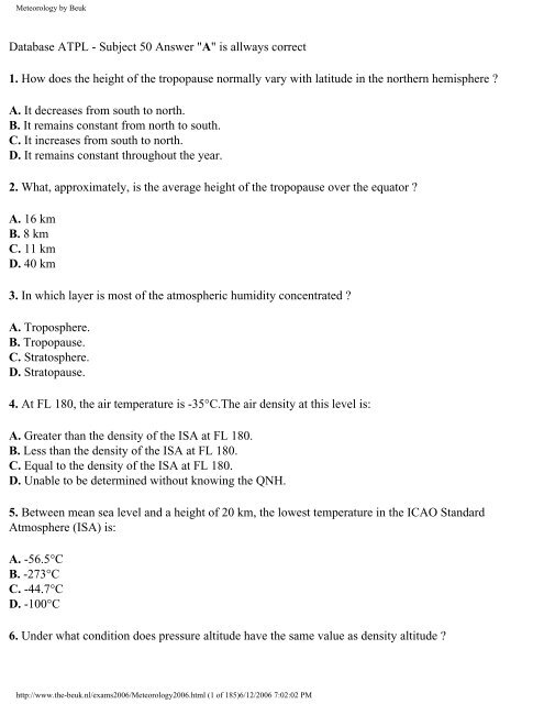
Database ATPL - Subject 50 Answer "A" is allways correct<br />
1. How does the height of the tropopause normally vary with latitude in the northern hemisphere ?<br />
A. It decreases from south to north.<br />
B. It remains constant from north to south.<br />
C. It increases from south to north.<br />
D. It remains constant throughout the year.<br />
2. What, approximately, is the average height of the tropopause over the equator ?<br />
A. 16 km<br />
B. 8 km<br />
C. 11 km<br />
D. 40 km<br />
3. In which layer is most of the atmospheric humidity concentrated ?<br />
A. Troposphere.<br />
B. Tropopause.<br />
C. Stratosphere.<br />
D. Stratopause.<br />
4. At FL 180, the air temperature is -35°C.The air density at this level is:<br />
A. Greater than the density of the ISA at FL 180.<br />
B. Less than the density of the ISA at FL 180.<br />
C. Equal to the density of the ISA at FL 180.<br />
D. Unable to be determined without knowing the QNH.<br />
5. Between mean sea level and a height of 20 km, the lowest temperature in the ICAO Standard<br />
Atmosphere (ISA) is:<br />
A. -56.5°C<br />
B. -273°C<br />
C. -44.7°C<br />
D. -100°C<br />
6. Under what condition does pressure altitude have the same value as density altitude ?<br />
http://www.the-beuk.nl/exams2006/<strong>Meteorology</strong>2006.html (1 of 185)6/12/2006 7:02:02 PM
<strong>Meteorology</strong> <strong>by</strong> <strong>Beuk</strong><br />
A. At standard temperature.<br />
B. At sea level when the temperature is 0°C.<br />
C. When the altimeter has no position error.<br />
D. When the altimeter setting is 1013.2 hPa.<br />
7. In the troposphere the decrease of pressure per 100 m increase in height<br />
A. is smaller at higher levels than at lower levels.<br />
B. remains constant at all levels.<br />
C. is greater at higher levels than at lower levels.<br />
D. is in the order of 27 hPa near MSL.<br />
8. Which FL corresponds with the 200 hPa pressure level ?<br />
A. FL 390.<br />
B. FL 300.<br />
C. FL 100.<br />
D. FL 50.<br />
9. What is the approximate vertical interval which is equal to a pressure change of 1 hPa at an altitude of<br />
5500 m ?<br />
A. 15 m (50 FT).<br />
B. 8 m (27 FT).<br />
C. 32 m (105 FT).<br />
D. 64 m (210 FT).<br />
10. In order to calculate QFE from QNH, which of the following must be known ?<br />
A. Elevation of the airfield.<br />
B. Temperature at the airfield.<br />
C. Elevation of the airfield and the temperature at MSL.<br />
D. Elevation and the temperature at the airfield.<br />
11. What is the dry adiabatic lapse rate ?<br />
A. 3.0°C/1000 FT<br />
B. 2.0°C/1000 FT<br />
C. 1.5°C/1000 FT<br />
D. 3.5°C/1000 FT<br />
12. A layer is conditionally unstable if the air<br />
http://www.the-beuk.nl/exams2006/<strong>Meteorology</strong>2006.html (2 of 185)6/12/2006 7:02:02 PM
<strong>Meteorology</strong> <strong>by</strong> <strong>Beuk</strong><br />
A. is unstable for saturated air and stable for dry air.<br />
B. is stable for saturated air and unstable for dry air.<br />
C. becomes stable <strong>by</strong> lifting it.<br />
D. is unstable for saturated air as well as for dry air.<br />
13. A parcel of unsaturated air is lifted to just below the condensation level and then returned to its<br />
original level. What is the final temperature of the parcel of air?<br />
A. The same as the starting temperature.<br />
B. Higher than the starting temperature.<br />
C. Lower than the starting temperature.<br />
D. It depends upon the QFE.<br />
14. What is the effect of a strong low level inversion ?<br />
A. It promotes vertical wind shear.<br />
B. It promotes extensive vertical movement of air.<br />
C. It prevents vertical wind shear.<br />
D. It results in good visual conditions near the surface.<br />
15. The temperature at FL 140 is -12°C. What will the temperature be at FL 110 if the ICAO standard<br />
lapse rate is applied ?<br />
A. -6°C.<br />
B. -18°C.<br />
C. -9°C.<br />
D. -15°C.<br />
16. If atmospheric conditions exist such that the temperature is ISA +10°C in the lower troposphere up<br />
to 18000 FT, what is the actual layer thickness between FL 60 and FL 120?<br />
A. 6240 FT.<br />
B. 6000 FT.<br />
C. 5900 FT.<br />
D. 5760 FT.<br />
17. Which of the following is a common cause of ground or surface temperature inversion ?<br />
A. Terrestrial radiation on a clear night with no or very light winds.<br />
B. Warm air being lifted rapidly aloft, in the vicinity of mountainous terrain.<br />
C. The movement of colder air under warm air, or the movement of warm air over cold air.<br />
http://www.the-beuk.nl/exams2006/<strong>Meteorology</strong>2006.html (3 of 185)6/12/2006 7:02:02 PM
<strong>Meteorology</strong> <strong>by</strong> <strong>Beuk</strong><br />
D. Heating of the air <strong>by</strong> subsidence<br />
18. At a certain position, the temperature on the 300 hPa chart is -48°C; according to the Significant<br />
Weather Chart, the tropopause is at FL 330. What is the most likely temperature at FL 350 ?<br />
A. -54°C.<br />
B. -50°C.<br />
C. -56,5°C.<br />
D. -58°C.<br />
19. What is the boundary layer between troposphere and stratosphere called?<br />
A. Tropopause.<br />
B. Ionosphere.<br />
C. Stratosphere.<br />
D. Atmosphere.<br />
20. Which constant pressure altitude chart is standard for FL50?<br />
A. 850 hPa.<br />
B. 700 hPa.<br />
C. 500 hPa.<br />
D. 300 hPa.<br />
21. An outside air temperature of -35°C is measured while cruising at FL 200. What is the temperature<br />
deviation from the ISA at this level?<br />
A. 10°C colder than ISA.<br />
B. 10°C warmer than ISA.<br />
C. 5°C warmer than ISA.<br />
D. 5°C colder than ISA.<br />
22. Convective activity over land in mid-latitudes is greatest in<br />
A. summer in the afternoon.<br />
B. winter during the night and early morning.<br />
C. summer during the night and early morning.<br />
D. winter in the afternoon.<br />
23. Which of the following is a possible consequence of subsidence?<br />
A. An inversion over a large area with haze, mist.<br />
http://www.the-beuk.nl/exams2006/<strong>Meteorology</strong>2006.html (4 of 185)6/12/2006 7:02:02 PM
<strong>Meteorology</strong> <strong>by</strong> <strong>Beuk</strong><br />
B. CB-clouds and thunderstorms over a large area.<br />
C. Wide spread NS and AS clouds and intense precipitation.<br />
D. Clear air turbulence at higher altitudes .<br />
24. The polar front is the boundary between:<br />
A. polar air and tropical air.<br />
B. arctic air and polar air.<br />
C. arctic air and tropical air.<br />
D. maritime polar air and continental polar air.<br />
25. What does dewpoint mean?<br />
A. The temperature to which a mass of air must be cooled in order to reach saturation.<br />
B. The temperature at which ice melts.<br />
C. The freezing level (danger of icing).<br />
D. The temperature at which the relative humidity and saturation vapour pressure are the same.<br />
26. Which of the following is the definition of relative humidity ?<br />
A. Ratio between the actual mixing ratio and the saturation mixing ratio X 100<br />
B. Ratio between air temperature and dewpoint temperature X 100<br />
C. Ratio between water vapour pressure and atmospheric pressure X 100<br />
D. Ratio between water vapour (g) and air (kg) X 100<br />
27. The relative humidity of a sample air mass is 50%. How is the relative humidity of this air mass<br />
influenced <strong>by</strong> changes of the amount of water vapour in it?<br />
A. It increases with increasing water vapour.<br />
B. It is not influenced <strong>by</strong> changing water vapour.<br />
C. It decreases with increasing water vapour.<br />
D. It is only influenced <strong>by</strong> temperature.<br />
28. Relative humidity<br />
A. changes when water vapour is added, even though the temperature remains constant.<br />
B. is not affected when air is ascending or descending.<br />
C. is not affected <strong>by</strong> temperature changes of the air.<br />
D. does not change when water vapour is added provided the temperature of the air remains constant.<br />
29. How, if at all, is the relative humidity of an unsaturated air mass influenced <strong>by</strong> temperature changes?<br />
http://www.the-beuk.nl/exams2006/<strong>Meteorology</strong>2006.html (5 of 185)6/12/2006 7:02:02 PM
<strong>Meteorology</strong> <strong>by</strong> <strong>Beuk</strong><br />
A. It decreases with increasing temperature.<br />
B. It is not influenced <strong>by</strong> temperature changes.<br />
C. It increases with increasing temperature.<br />
D. It is only influenced <strong>by</strong> the amount of water vapour.<br />
30. How does relative humidity and the dewpoint in an unsaturated air mass change with varying<br />
temperature?<br />
A. When temperature increases, the relative humidity decreases, and the dewpoint remains constant.<br />
B. When temperature increases, the relative humidity increases, and the dewpoint decreases.<br />
C. When temperature decreases, the relative humidity decreases, and the dewpoint increases.<br />
D. When temperature decreases, the relative humidity and the dewpoint remain constant.<br />
31. When a given mass of air descends, what effect will it have on relative humidity?<br />
A. It decreases.<br />
B. It increases.<br />
C. It remains constant.<br />
D. It increases up to 100%, then remains stable.<br />
32. During the late afternoon an air temperature of +12°C and a dew point of +5°C were measured.<br />
What temperature change must at least occur during the night in order to induce saturation?<br />
A. It must decrease to +5°C.<br />
B. It must decrease <strong>by</strong> 5°C.<br />
C. It must decrease to +6°C.<br />
D. It must decrease to +7°C.<br />
33. Which of the following changes of state is known as sublimation (in meteorology)?<br />
A. Solid direct to vapour<br />
B. Solid direct to liquid<br />
C. Liquid direct to solid<br />
D. Liquid direct to vapour<br />
34. Clouds, fog or dew will always be formed when:<br />
A. water vapour condenses.<br />
B. water vapour is present.<br />
C. relative humidity reaches 98%.<br />
D. temperature and dew point are nearly equal.<br />
http://www.the-beuk.nl/exams2006/<strong>Meteorology</strong>2006.html (6 of 185)6/12/2006 7:02:02 PM
<strong>Meteorology</strong> <strong>by</strong> <strong>Beuk</strong><br />
35. Which of the following are favourable conditions for the formation of freezing rain?<br />
A. Warm air aloft from which rain is falling into air with a temperature below 0°C.<br />
B. Water droplets falling from cold air aloft with a temperature below 0°C into air with a temperature<br />
above 0°C.<br />
C. Cold air aloft from which hail is falling into air that is warm.<br />
D. An isothermal layer aloft with a temperature just above 0°C through which rain is falling.<br />
36. Which form of precipitation from clouds containing only water is most likely to fall in mid-latitudes?<br />
A. Drizzle.<br />
B. Moderate rain with large drops.<br />
C. Heavy rain with large drops.<br />
D. Hail.<br />
37. Which of the following zones is most likely to encounter little or no precipitation?<br />
A. The north side of the alps with a prevailing Foehn from the south.<br />
B. The north side of the alps with a prevailing Foehn from the north.<br />
C. Frontal zones.<br />
D. Occlusions.<br />
38. Which of the following is a cause of stratus forming over flat land?<br />
A. Radiation during the night from the earth surface in moderate wind.<br />
B. Unstable air.<br />
C. Convection during the day.<br />
D. The release of latent heat.<br />
39. Which of the following processes within a layer of air may lead to the building of CU and CB<br />
clouds?<br />
A. Convection.<br />
B. Radiation.<br />
C. Subsidence.<br />
D. Frontal lifting within stable layers.<br />
40. What are the characteristics of cumuliform clouds?<br />
A. Large water droplets, instability, turbulence, showers and mainly clear ice.<br />
B. Small water droplets, stability, no turbulence and extensive areas of rain.<br />
http://www.the-beuk.nl/exams2006/<strong>Meteorology</strong>2006.html (7 of 185)6/12/2006 7:02:02 PM
<strong>Meteorology</strong> <strong>by</strong> <strong>Beuk</strong><br />
C. Large water droplets, stability, no turbulence, showers and mainly rime ice.<br />
D. Small water droplets, instability, turbulence, extensive areas of rain and rime ice.<br />
41. Which of the following types of clouds are evidence of unstable air conditions?<br />
A. CU, CB.<br />
B. ST, CS.<br />
C. SC, NS.<br />
D. CI, SC.<br />
42. Which of the following clouds are classified as medium level clouds in temperate regions ?<br />
A. AS, AC.<br />
B. SC, NS<br />
C. CI, CC.<br />
D. CS, ST.<br />
43. ''(For this question use annex 050-1914A)<br />
Which one of the displayed cloud forms is representative of altocumulus castellanus?''<br />
A. 3.<br />
B. 1.<br />
C. 2.<br />
D. 4.<br />
44. What is the main composition of clouds classified as ''high level clouds''?<br />
A. Ice crystals.<br />
B. Supercooled water droplets.<br />
C. Water droplets.<br />
D. Water vapour.<br />
45. A plain in Western Europe with an average elevation of 500 m (1600 FT) above sea level is covered<br />
with a uniform AC layer of cloud during the summer months. At what height above the ground is the<br />
base of this cloud to be expected?<br />
A. 7000 - 15000 FT above the terrain.<br />
B. 100 - 1500 FT above the terrain.<br />
C. 1500 - 7000 FT above the terrain.<br />
D. 15000 - 25000 FT above the terrain.<br />
46. Which of the following clouds may extend into more than one layer?<br />
http://www.the-beuk.nl/exams2006/<strong>Meteorology</strong>2006.html (8 of 185)6/12/2006 7:02:02 PM
<strong>Meteorology</strong> <strong>by</strong> <strong>Beuk</strong><br />
A. Nimbostratus.<br />
B. Stratus.<br />
C. Altocumulus.<br />
D. Cirrus.<br />
47. Which one of the following types of cloud is most likely to produce heavy precipitation ?<br />
A. NS.<br />
B. CS.<br />
C. SC.<br />
D. ST.<br />
48. What characteristics will the surface winds have in an area where the isobars on the weather map are<br />
very close together?<br />
A. Strong and flowing across the isobars.<br />
B. Very weak but gusty and flowing across the isobars.<br />
C. Strong and flowing parallel to the isobars.<br />
D. Moderate and flowing parallel to the isobars.<br />
49. Which forces are balanced with geostrophic winds?<br />
A. Pressure gradient force, Coriolis force.<br />
B. Friction force, pressure gradient force, Coriolis force.<br />
C. Pressure gradient force, Coriolis force, centrifugal force.<br />
D. Pressure gradient force, centrifugal force, friction force.<br />
50. How does moderate turbulence affect an aircraft?<br />
A. Changes in altitude or attitude occur but the aircraft remains in positive control at all times.<br />
B. Rapid and somewhat rhythmic bumpiness is experienced without appreciable changes in altitude or<br />
attitude.<br />
C. Large, abrupt changes in altitude or attitude occur but the aircraft may only be out of control<br />
momentarily.<br />
D. Continued flight in this environment will result in structural damage.<br />
51. ''Which degree of aircraft turbulence is determined <strong>by</strong> the following ICAO description?<br />
''There may be moderate changes in aircraft attitude and/or altitude but the aircraft remains in positive<br />
control at all times. Usually, small variations in air speed. Changes in accelerometer readings of 0.5 to<br />
1.0 g at the aircraft's centre of gravity. Occupants feel strain against seat belts. Loose objects move<br />
about. Food service and walking are difficult.''''<br />
http://www.the-beuk.nl/exams2006/<strong>Meteorology</strong>2006.html (9 of 185)6/12/2006 7:02:02 PM
<strong>Meteorology</strong> <strong>by</strong> <strong>Beuk</strong><br />
A. Moderate.<br />
B. Light.<br />
C. Severe.<br />
D. Violent.<br />
52. For an aircraft what are the meteorological dangers associated with a Harmattan wind?<br />
A. Dust and poor visibility.<br />
B. Thunderstorms.<br />
C. Sand up to FL 150.<br />
D. Hail.<br />
53. What is the strong relatively cold katabatic wind, blowing down the northern Adriatic coast, mainly<br />
during the winter and spring called?<br />
A. Bora.<br />
B. Ghibli.<br />
C. Mistral.<br />
D. Scirocco.<br />
54. In a land- and sea-breeze circulation the land-breeze blows:<br />
A. during the night and is weaker than the sea-breeze.<br />
B. during the day and is stronger than the sea-breeze.<br />
C. during the day and is weaker than the sea-breeze.<br />
D. during the night and is stronger than the sea-breeze.<br />
55. A high pressure area (slack pressure gradient) covers part of the Mediterranean Sea and coastal<br />
region during the summer. What surface wind direction is likely at an airport at the coast on a sunny<br />
afternoon?<br />
A. Sea to land.<br />
B. Land to sea.<br />
C. Variable.<br />
D. Parallel to the coastline.<br />
56. A mountain breeze (katabatic wind) blows<br />
A. down the slope during the night.<br />
B. up the slope during the day.<br />
C. down the slope during the day.<br />
http://www.the-beuk.nl/exams2006/<strong>Meteorology</strong>2006.html (10 of 185)6/12/2006 7:02:02 PM
<strong>Meteorology</strong> <strong>by</strong> <strong>Beuk</strong><br />
D. up the slope during the night.<br />
57. Generally northern hemisphere winds at 5000 FT/AGL are south-westerly while most of the surface<br />
winds are southerly. What is the primary reason of difference between these two wind directions?<br />
A. Friction between the wind and the surface.<br />
B. A strong pressure gradient at higher altitudes.<br />
C. Stronger Coriolis force at the surface.<br />
D. The influence of warm air at the lower altitude.<br />
58. Friction between the air and the ground results in the northern hemisphere in:<br />
A. backing of the wind and decrease of wind speed at the surface.<br />
B. veering of the wind and decrease of wind speed at the surface.<br />
C. backing of the wind and increase of wind speed at the surface.<br />
D. veering of the wind and increase of wind speed at the surface.<br />
59. Whilst flying at FL 180 on the northern hemisphere an aircraft experiences right drift. What effect, if<br />
any, will this have on the aircraft's true altitude ?<br />
A. It decreases<br />
B. It increases.<br />
C. It remains constant.<br />
D. Without knowing the pressure change this question cannot be answered.<br />
60. What is the most likely temperature at the tropical tropopause?<br />
A. -75°C.<br />
B. -55°C.<br />
C. -35°C.<br />
D. -25°C.<br />
61. Which weather condition lowers true altitude as compared to pressure altitude to a position where<br />
flight over mountains could be dangerous?<br />
A. Cold low.<br />
B. Warm depression.<br />
C. Cold high.<br />
D. Warm high.<br />
62. In the southern hemisphere what wind effect would you expect when flying from a high pressure<br />
area towards a low pressure area at FL 100?<br />
http://www.the-beuk.nl/exams2006/<strong>Meteorology</strong>2006.html (11 of 185)6/12/2006 7:02:02 PM
<strong>Meteorology</strong> <strong>by</strong> <strong>Beuk</strong><br />
A. Wind from the right.<br />
B. Wind from the left.<br />
C. Tailwind with no drift.<br />
D. Headwind with no drift.<br />
63. What degree of turbulence, if any, is likely to be encountered while flying through a cold front in the<br />
summer over Central Europe at FL 100?<br />
A. Severe turbulence in CB cloud.<br />
B. Moderate turbulence in NS cloud.<br />
C. Light turbulence in CB cloud.<br />
D. Light turbulence in ST cloud.<br />
64. You are flying at 2 500 FT/AGL, the wind is 180°, and intend to land at an airport, at sea level<br />
directly below. From approximately which direction would you expect the surface wind (mid-latitude,<br />
northern hemisphere)?<br />
A. South-southeast.<br />
B. South-southwest.<br />
C. Southwest.<br />
D. South.<br />
65. What are the typical differences with regard to the temperature and humidity between an air mass<br />
with its origin in the Azores and an air mass with its origin over northern Russia ?<br />
A. The air of the Azores is warmer and more humid than the North-Russian air.<br />
B. The North-Russian air is colder and more humid than the air of the Azores.<br />
C. The air of the Azores is warmer and dryer than the North-Russian air.<br />
D. The North-Russian air is warmer and dryer than the air of the Azores.<br />
66. Where is the source of tropical continental air that affects Europe in summer?<br />
A. The southern Balkan region and the Near East.<br />
B. Southern Italy.<br />
C. Southern France.<br />
D. The Azores region.<br />
67. Where does polar continental air originate?<br />
A. Siberian landmass.<br />
B. Polar ice cap.<br />
http://www.the-beuk.nl/exams2006/<strong>Meteorology</strong>2006.html (12 of 185)6/12/2006 7:02:02 PM
<strong>Meteorology</strong> <strong>by</strong> <strong>Beuk</strong><br />
C. The region of Azores.<br />
D. The region of the British Isles.<br />
68. In which air mass are extremely low temperatures encountered?<br />
A. Polar continental air.<br />
B. Polar maritime air.<br />
C. Tropical continental air.<br />
D. Arctic maritime air.<br />
69. With what type of clouds are showers most likely associated?<br />
A. Cumulonimbus.<br />
B. Stratocumulus.<br />
C. Nimbostratus.<br />
D. Stratus.<br />
70. At what time of day, or night, is radiation fog most likely to occur?<br />
A. Shortly after sunrise.<br />
B. At sunset.<br />
C. Late evening.<br />
D. Shortly after midnight.<br />
71. What is the average vertical extent of radiation fog?<br />
A. 500 FT.<br />
B. 2 000 FT.<br />
C. 5 000 FT.<br />
D. 10 000 FT.<br />
72. Which of the following weather conditions favour the formation of radiation fog?<br />
A. Light wind, little or no cloud, moist air.<br />
B. Light wind, extensive cloud, dry air.<br />
C. Light wind, extensive cloud, moist air.<br />
D. Strong wind, little or no cloud, moist air.<br />
73. What type of fronts are most likely to be present during the winter in Central Europe when<br />
temperatures close to the ground are below 0°C, and freezing rain starts to fall?<br />
A. Warm fronts, warm occlusions.<br />
http://www.the-beuk.nl/exams2006/<strong>Meteorology</strong>2006.html (13 of 185)6/12/2006 7:02:02 PM
<strong>Meteorology</strong> <strong>by</strong> <strong>Beuk</strong><br />
B. Cold occlusions.<br />
C. High level cold fronts.<br />
D. Cold fronts.<br />
74. Which of the following conditions are you most likely to encounter when approaching an active<br />
warm front at medium to low level ?<br />
A. Low cloud base and poor visibility.<br />
B. Severe thunderstorms at low altitude.<br />
C. Extreme turbulence and severe lightning striking the ground.<br />
D. High cloud base, good surface visibility, and isolated thunderstorms.<br />
75. ''During a cross-country flight at FL 50, you observe the following sequence of clouds:<br />
Nimbostratus, Altostratus, Cirrostratus, Cirrus.<br />
Which of the following are you most likely to encounter ?''<br />
A. Decreasing temperatures.<br />
B. Strong, gusty winds.<br />
C. A strong downdraught.<br />
D. Increasing temperatures.<br />
76. What cloud formation is most likely to occur at low levels when a warm air mass overrides a cold air<br />
mass?<br />
A. Nimbostratus.<br />
B. Cumulus.<br />
C. Altostratus.<br />
D. Cumulonimbus.<br />
77. The approximate inclined plane of a warm front is:<br />
A. 1/150<br />
B. 1/50<br />
C. 1/300<br />
D. 1/500<br />
78. What type of low pressure area is associated with a surface front?<br />
A. Polar front low.<br />
B. A cold air pool.<br />
C. A low on lee side of a mountain.<br />
D. Heat low.<br />
http://www.the-beuk.nl/exams2006/<strong>Meteorology</strong>2006.html (14 of 185)6/12/2006 7:02:02 PM
<strong>Meteorology</strong> <strong>by</strong> <strong>Beuk</strong><br />
79. In which approximate direction does the centre of a non-occluded frontal depression move?<br />
A. In the direction of the warm sector isobars.<br />
B. In the direction of the isobars ahead of the warm front.<br />
C. In the direction of the sharpest pressure increase.<br />
D. In the direction of the isobars behind the cold front.<br />
80. Where is the coldest air to be found, in an occlusion with cold front characteristics?<br />
A. Behind the front.<br />
B. Ahead of the front.<br />
C. At the surface position of the front.<br />
D. At the junction of the occlusion.<br />
81. What type of front / occlusion usually moves the fastest?<br />
A. Cold front.<br />
B. Warm front.<br />
C. Cold occlusion.<br />
D. Warm occlusion.<br />
82. Over Central Europe what type of cloud cover is typical of the warm sector of a depression during<br />
winter?<br />
A. ST.<br />
B. CI, CS.<br />
C. Fair weather CU.<br />
D. CU, CB.<br />
83. What weather conditions are prevalent during the summer, over the North Sea, approximately 300<br />
km behind a quickly moving cold front?<br />
A. Cloud cover mostly scattered, isolated showers.<br />
B. Advection fog.<br />
C. Rain covering a large area, 8 octas NS.<br />
D. 8 octas CS, AS without precipitation.<br />
84. What is the surface visibility most likely to be, in a warm sector of tropical maritime air, during a<br />
summer afternoon in western Europe ?<br />
A. Moderate (several km).<br />
http://www.the-beuk.nl/exams2006/<strong>Meteorology</strong>2006.html (15 of 185)6/12/2006 7:02:02 PM
<strong>Meteorology</strong> <strong>by</strong> <strong>Beuk</strong><br />
B. Very poor (less than 1 km).<br />
C. Good (greater than 10 km).<br />
D. Very good (greater than 50 km).<br />
85. Which one of the following statements regarding the intertropical convergence zone (ITCZ) is<br />
correct?<br />
A. Frequent and widespread thunderstorms are to be expected within the area of the ITCZ.<br />
B. Thunderstorms seldom occur within the area of the ITCZ.<br />
C. The ITCZ is always associated with a strong jet stream.<br />
D. The ITCZ does not change its position during the course of the year.<br />
86. In which of the following bands of latitude is the intertropical convergence zone most likely to be<br />
encountered in January, between Dakar and Rio de Janeiro?<br />
A. 0° - 7°N.<br />
B. 3° - 8°S.<br />
C. 8° - 12°S.<br />
D. 7° - 12°N.<br />
87. What weather conditions are indications of the summer monsoon in India?<br />
A. Thunderstorms, showers of heavy rain.<br />
B. Stratus clouds and drizzle.<br />
C. Sandstorms.<br />
D. Fog.<br />
88. After passing at right angles through a very active cold front in the direction of the cold air, what<br />
will you encounter at FL 50, in the northern hemisphere immediately after a marked change in<br />
temperature?<br />
A. A veering in the wind direction.<br />
B. A backing in the wind direction.<br />
C. An increase in tailwind.<br />
D. A decrease in tailwind.<br />
89. When are the rainy seasons in equatorial Africa?<br />
A. March to May and October to November.<br />
B. December to February and July to October.<br />
C. March to May and August to October.<br />
D. April to July and December to February.<br />
http://www.the-beuk.nl/exams2006/<strong>Meteorology</strong>2006.html (16 of 185)6/12/2006 7:02:02 PM
<strong>Meteorology</strong> <strong>by</strong> <strong>Beuk</strong><br />
90. Which of the following best describes the intertropical convergence zone ?<br />
A. The zone where the trade winds of the northern hemisphere meet those of the southern hemisphere.<br />
B. The zone where the Harmattan meets the north-easterly trade winds over Africa.<br />
C. The zone where cold fronts form in the tropics.<br />
D. The zone where the west winds meet the subtropical high pressure belt.<br />
91. What is the likely track for a hurricane in the Caribbean area?<br />
A. West in the earlier stages and later turning north east.<br />
B. East then south.<br />
C. West deep into the USA.<br />
D. West in the earlier stages and later turning south east.<br />
92. During which seasons are hurricanes most likely to appear in the northern hemisphere?<br />
A. Summer and autumn.<br />
B. Winter.<br />
C. Winter and spring.<br />
D. All seasons.<br />
93. What is encountered during the summer, over land, in the centre of a cold air pool?<br />
A. Showers and thunderstorms.<br />
B. Strong westerly winds.<br />
C. Fine weather CU.<br />
D. Sky clear (SKC).<br />
94. How do you recognize a cold air pool?<br />
A. As a low pressure area aloft (e.g. on the 500 hPa chart).<br />
B. As a high pressure area aloft (e.g. on the 500 hPa chart).<br />
C. A cold air pool may only be recognized on the surface chart as a low pressure area.<br />
D. A cold air pool may only be recognized on the surface chart as a high pressure area.<br />
95. What is the correct term for the descending air flow in a large high pressure area?<br />
A. Subsidence.<br />
B. Convergence.<br />
C. Advection.<br />
D. Convection.<br />
http://www.the-beuk.nl/exams2006/<strong>Meteorology</strong>2006.html (17 of 185)6/12/2006 7:02:02 PM
<strong>Meteorology</strong> <strong>by</strong> <strong>Beuk</strong><br />
96. What surface weather is associated with a stationary high pressure region over land in the winter?<br />
A. A tendency for fog and low ST.<br />
B. Thunderstorms.<br />
C. NS with continuous rain.<br />
D. The possibility of snow showers.<br />
97. In temperate latitudes what weather conditions may be expected over land during the summer in the<br />
centre of a stationary high pressure zone ?<br />
A. Calm winds, haze.<br />
B. TS, SH.<br />
C. CB, TS.<br />
D. NS.<br />
98. At what time of the year, are the paths of north Atlantic lows moving from west to east generally at<br />
their most southerly position?<br />
A. Winter.<br />
B. Summer.<br />
C. Spring.<br />
D. Autumn.<br />
99. What is the relationship between visibility and RVR in homogeneous fog?<br />
A. The visibility generally is less than the RVR.<br />
B. The visibility generally is greater than the RVR.<br />
C. The visibility generally is the same as the RVR.<br />
D. There is no specific relationship between the two.<br />
100. The wind indicator for a weather observation receives the measured value from an anemometer.<br />
Where is this instrument placed?<br />
A. On a mast 6-10 m above the runway.<br />
B. 1 m above the runway.<br />
C. Close to the station about 2 m above the ground.<br />
D. On the roof of the weather station.<br />
101. You are flying with an outside air temperature of -12°C and a TAS of 250 kt at FL 150 through 8<br />
oktas NS. What type and degree of icing is most probable?<br />
http://www.the-beuk.nl/exams2006/<strong>Meteorology</strong>2006.html (18 of 185)6/12/2006 7:02:02 PM
<strong>Meteorology</strong> <strong>by</strong> <strong>Beuk</strong><br />
A. In clouds pushed up against the mountains, moderate to severe mixed ice.<br />
B. In clouds pushed up against the mountains, moderate to severe clear ice.<br />
C. Over flat terrain, away from fronts, moderate to severe mixed ice.<br />
D. Over flat terrain, moderate hoar frost.<br />
102. You intend to carry out a VFR flight over the Alps, on a fine and hot summer day. What is the best<br />
time of day to conduct this flight?<br />
A. Morning.<br />
B. Mid-day.<br />
C. Afternoon.<br />
D. Early evening.<br />
103. At what time of the year are tornadoes most likely to occur in North America?<br />
A. Spring, summer.<br />
B. Summer, autumn.<br />
C. Autumn, winter.<br />
D. Winter.<br />
104. In Central Europe when is the greatest likelihood for thunderstorms due to warm updrafts?<br />
A. Mid - afternoon.<br />
B. Around midnight.<br />
C. Early morning.<br />
D. Late morning.<br />
105. During which stage of thunderstorm development are rotor winds characterized <strong>by</strong> roll clouds most<br />
likely to occur ?<br />
A. Mature stage.<br />
B. Cumulus stage.<br />
C. Dissipating stage.<br />
D. Cumulus stage and mature stage.<br />
106. Where is a squall line to be expected?<br />
A. In front of an active cold front.<br />
B. Behind a cold front.<br />
C. In front of a cold front occlusion at higher levels.<br />
D. At the surface position of a warm front.<br />
http://www.the-beuk.nl/exams2006/<strong>Meteorology</strong>2006.html (19 of 185)6/12/2006 7:02:02 PM
<strong>Meteorology</strong> <strong>by</strong> <strong>Beuk</strong><br />
107. What are squall lines?<br />
A. Bands of intensive thunderstorms.<br />
B. Unusual intensive cold fronts.<br />
C. The surface weather associated with upper air troughs.<br />
D. The paths of tropical revolving storms.<br />
108. Which weather phenomena are typical for the northern side of the Alps with strong winds from the<br />
south (Foehn)?<br />
A. Good visibility, turbulence.<br />
B. Continuous precipitation, severe turbulence.<br />
C. Decrease in temperature, moderate to severe icing.<br />
D. Icing, huge mass of clouds.<br />
109. What weather is prevalent in easterly waves?<br />
A. Thunderstorms and rain.<br />
B. Continuous rain.<br />
C. Clear skies.<br />
D. Frontal weather.<br />
110. What winds and air mass characteristics are mainly associated with the winter monsoon in the<br />
monsoon regions of the Indian sub-continent?<br />
A. North-easterly winds bringing dry and hazy air.<br />
B. South-westerly winds carrying warm and humid air.<br />
C. North-westerly winds bringing dry and hazy air.<br />
D. South-easterly winds carrying warm and humid air.<br />
111. What is the meaning of the expression ''FEW''?<br />
A. 1 - 2 oktas.<br />
B. 3 - 4 oktas.<br />
C. 5 - 7 oktas.<br />
D. 8 oktas.<br />
112. When is the RVR reported at most airports?<br />
A. When the visibility decreases below 1500 m.<br />
B. When the visibility decreases below 2000 m.<br />
C. When the RVR decreases below 2500 m.<br />
http://www.the-beuk.nl/exams2006/<strong>Meteorology</strong>2006.html (20 of 185)6/12/2006 7:02:02 PM
<strong>Meteorology</strong> <strong>by</strong> <strong>Beuk</strong><br />
D. When the RVR decreases below 2000 m.<br />
113. How is the direction and speed of upper winds described in forecasts ?<br />
A. The direction is relative to true north and the speed is in knots.<br />
B. The direction is relative to magnetic north and the speed is in knots.<br />
C. The direction is relative to magnetic north and the speed is in miles per hour.<br />
D. The direction is relative to true north and the speed is in miles per hour.<br />
114. What positions are connected <strong>by</strong> contour lines on a weather chart?<br />
A. Positions with the same height in a chart of constant pressure.<br />
B. Positions with the same thickness between two constant pressure levels.<br />
C. Positions with the same air density.<br />
D. Positions with the same wind velocity.<br />
115. In which meteorological forecast chart is information about CAT regions found?<br />
A. Significant Weather Chart.<br />
B. 24 hour surface forecast.<br />
C. 500 hPa chart.<br />
D. 300 hPa chart.<br />
116. On which of the following aviation weather charts can a pilot most easily find a jetstream?<br />
A. Significant weather chart.<br />
B. Wind / temperature chart.<br />
C. Surface chart.<br />
D. Upper air chart.<br />
117. What is the best approximation for the wind speed at flight level 250?<br />
A. By interpolation of the wind information available from the 500 and 300 hPa charts, while also<br />
considering the maximum wind information found on the Significant Weather Chart.<br />
B. By simple interpolation of wind information available from the 500 and 300 hPa charts.<br />
C. By reading wind direction and speed from the 500 hPa chart.<br />
D. By reading wind direction and speed from the 300 hPa chart.<br />
118. Why are indications about the height of the tropopause not essential for flight documentation in the<br />
tropics?<br />
http://www.the-beuk.nl/exams2006/<strong>Meteorology</strong>2006.html (21 of 185)6/12/2006 7:02:02 PM
<strong>Meteorology</strong> <strong>by</strong> <strong>Beuk</strong><br />
A. The tropopause is generally well above the flight level actually flown.<br />
B. The meteorological services are unable to provide such a chart.<br />
C. The temperatures of the tropical tropopause are always very low and therefore not important.<br />
D. The tropopause is always at the same height.<br />
119. In the TAF for Dehli, during the summer, for the time of your landing you note: TEMPO TS. What<br />
is the maximum time this deterioration in weather can last in anyone instance ?<br />
A. 60 minutes.<br />
B. 120 minutes.<br />
C. 10 minutes.<br />
D. 20 minutes.<br />
120. How are well separated CB clouds described on the Significant Weather Chart?<br />
A. OCNL CB.<br />
B. EMBD CB.<br />
C. FRQ CB.<br />
D. ISOL CB.<br />
121. ''(For this question use annex 050-2055A rev. 20.01.2003)<br />
The cold front is indicated <strong>by</strong>:''<br />
A. number 2<br />
B. number 1<br />
C. number 3<br />
D. number 4<br />
122. ''(For this question use annex 050-2056A)<br />
Of the four radio soundings, select the one that indicates ground fog:''<br />
A. 2<br />
B. 1<br />
C. 3<br />
D. 4<br />
123. ''(For this question use annex 050-2058A)<br />
What does the symbol indicate on a Significant Weather Chart?''<br />
A. The centre of a tropopause ''high'', where the tropopause is at FL 400.<br />
B. The centre of a high pressure area at 400 hPa.<br />
C. The upper limit of significant weather at FL 400.<br />
http://www.the-beuk.nl/exams2006/<strong>Meteorology</strong>2006.html (22 of 185)6/12/2006 7:02:02 PM
<strong>Meteorology</strong> <strong>by</strong> <strong>Beuk</strong><br />
D. The lower limit of the tropopause.<br />
124. ''(For this question use annex 050-2059A)<br />
Which typical weather situation is shown on the weather chart ? (Spacing of the isobars: 5 hPa)''<br />
A. Uniform pressure pattern.<br />
B. Cutting wind.<br />
C. West wind condition.<br />
D. Warm south wind condition (Foehn).<br />
125. ''(For this question use annex 050-2060A)<br />
Which one of the tracks (dashed lines) is represented <strong>by</strong> the cross-section shown on the left ?''<br />
A. Track D-A<br />
B. Track C-A<br />
C. Track B-A<br />
D. Track B-C<br />
126. ''(For this question use annex 050-2061A)<br />
Which cross-section of air mass and cloud presentation is applicable to the straight line A-B?''<br />
A. 3<br />
B. 1<br />
C. 2<br />
D. 4<br />
127. ''(For this question use annex 050-2064A)<br />
Assuming the usual direction of movement, where will this polar frontal wave have moved to (after a<br />
certain time)?''<br />
A. Position 3<br />
B. Position 1<br />
C. Position 2<br />
D. Position 4<br />
128. ''(For this question use annex 050-2065A)<br />
What is the classification of the air mass affecting position ''Q'' ?''<br />
A. Tropical maritime.<br />
B. Polar maritime.<br />
C. Polar continental.<br />
D. Tropical continental.<br />
http://www.the-beuk.nl/exams2006/<strong>Meteorology</strong>2006.html (23 of 185)6/12/2006 7:02:02 PM
<strong>Meteorology</strong> <strong>by</strong> <strong>Beuk</strong><br />
129. Which of the following cloud types can project up into the stratosphere?<br />
A. Cumulonimbus<br />
B. Cirrostratus<br />
C. Altocumulus<br />
D. Altostratus<br />
130. Which one of the following statements applies to the tropopause?<br />
A. It separates the troposphere from the stratosphere<br />
B. It is, <strong>by</strong> definition, an isothermal layer<br />
C. It indicates a strong temperature lapse rate<br />
D. It is, <strong>by</strong> definition, a temperature inversion<br />
131. The 0° isotherm is forecast to be at FL 50. At what FL would you expect a temperature of -6° C?<br />
A. FL 80<br />
B. FL 20<br />
C. FL 100<br />
D. FL 110<br />
132. What positions are connected <strong>by</strong> isobars on the surface weather chart?<br />
A. Positions with the same air pressure at a given level<br />
B. Positions with the same temperature at a given level<br />
C. Positions with the same wind velocity at a given level<br />
D. Positions with the same relative pressure heights<br />
133. A vertical spacing of 1000 FT is the standard required separation between two FL. Under<br />
conditions of cold air advection (ISA -15°C), what would the true vertical separation be?<br />
A. Less than 1000 FT<br />
B. It remains 1000 FT<br />
C. More than 1000 FT<br />
D. Without QNH information, it can not be determined<br />
134. At which pressure and temperature conditions may you safely assume that the minimum usable<br />
flight level at least lies at the same height, as the minimum safe altitude?<br />
A. At a temperature greater than or equal to that of the ISA and where the QNH is greater than or equal<br />
to 1013.25 hPa<br />
http://www.the-beuk.nl/exams2006/<strong>Meteorology</strong>2006.html (24 of 185)6/12/2006 7:02:02 PM
<strong>Meteorology</strong> <strong>by</strong> <strong>Beuk</strong><br />
B. In a cold low pressure region<br />
C. At a temperature less than or equal to that of the ISA and where the QNH is less than 1013.25 hPa<br />
D. In a very cold area with a QNH of 1015 hPa<br />
135. What is the main cause for the formation of a polar front jet stream?<br />
A. The north-south horizontal temperature gradient at the polar front<br />
B. The pressure difference, close to the ground, between a high over the Azores and a low over Iceland<br />
C. The varied elevations of the tropopause in the polar front region<br />
D. Strong winds in the upper atmosphere<br />
136. Which jet stream is connected with a surface front system?<br />
A. The polar front jet stream<br />
B. The easterly jet stream<br />
C. The subtropical jet stream<br />
D. The equatorial jet stream<br />
137. At approximately what flight level is the subtropical jet stream found?<br />
A. FL 400<br />
B. FL 200<br />
C. FL 300<br />
D. FL 500<br />
138. A parcel of moist but not saturated air rises due to adiabatic effects. Which of the following<br />
changes ?<br />
A. Relative humidity<br />
B. Absolute humidity<br />
C. Mixing ratio<br />
D. Specific humidity<br />
139. In which of the following changes of state is latent heat released ?<br />
A. Gas to liquid<br />
B. Solid to liquid<br />
C. Solid to gas<br />
D. Liquid to gas<br />
140. How are high level condensation trails formed that are to be found occasionally behind jet aircraft ?<br />
http://www.the-beuk.nl/exams2006/<strong>Meteorology</strong>2006.html (25 of 185)6/12/2006 7:02:02 PM
<strong>Meteorology</strong> <strong>by</strong> <strong>Beuk</strong><br />
A. Through water vapour released during fuel combustion<br />
B. Through a decrease in pressure, and the associated adiabatic drop in temperature at the wing tips<br />
while flying through relatively warm but humid air<br />
C. Only through unburnt fuel in the exhaust gases<br />
D. In conditions of low humidity, through the particles of soot contained in the exhaust gases<br />
141. What process in an air mass leads to the creation of wide spread NS and AS cloud coverage?<br />
A. Lifting<br />
B. Sinking<br />
C. Convection process<br />
D. Radiation<br />
142. Which of the following cloud is classified as low level cloud ?<br />
A. ST<br />
B. CS<br />
C. AS<br />
D. CC<br />
143. In which of the following conditions is moderate to severe airframe icing most likely to be<br />
encountered?<br />
A. In Nimbostratus cloud<br />
B. Below the freezing level in clear air<br />
C. In clear air above the freezing level<br />
D. Within cloud of any type<br />
144. What flying conditions are normally encountered when flying in cirrus clouds?<br />
A. Average horizontal visibility more than 1000 m; nil icing.<br />
B. Average horizontal visibility less than 500 m; nil icing.<br />
C. Average horizontal visibility less than 500 m; light to moderate icing.<br />
D. Average horizontal visibility more than 1000 m; light to moderate rime ice.<br />
145. Which of the following is most likely to lead to the dissipation of radiation fog ?<br />
A. A marked increase in wind velocity near the ground<br />
B. A marked decrease in wind velocity close to the ground<br />
C. Ground cooling caused <strong>by</strong> radiation during the night<br />
D. A build up of a high pressure area resulting in adiabatic warming associated with a sinking air mass<br />
http://www.the-beuk.nl/exams2006/<strong>Meteorology</strong>2006.html (26 of 185)6/12/2006 7:02:02 PM
<strong>Meteorology</strong> <strong>by</strong> <strong>Beuk</strong><br />
146. Which of the following conditions is most likely to lead to the formation of steam fog (arctic<br />
smoke)?<br />
A. Cold air moving over warm water<br />
B. Warm air moving over cold water<br />
C. The sea is warmed <strong>by</strong> strong radiation from the sun<br />
D. The coastal region of the sea cools at night<br />
147. How does freezing rain develop?<br />
A. Rain falls through a layer where temperatures are below 0°C<br />
B. Snow falls through a layer where temperatures are above 0°C<br />
C. Through melting of snow grains<br />
D. Through melting of ice crystals<br />
148. What type of cloud can produce hail showers?<br />
A. CB<br />
B. NS<br />
C. CS<br />
D. AC<br />
149. In which of the following regions does polar maritime air originate ?<br />
A. East of Greenland<br />
B. Region of British Isles<br />
C. Baltic Sea<br />
D. Black Sea<br />
150. In which of the following situations can freezing rain be encountered ?<br />
A. Ahead of a warm front in the winter<br />
B. Ahead of a cold front in the winter<br />
C. Behind a warm front in the summer<br />
D. Ahead of a cold front in the summer<br />
151. How do air masses move at a warm front ?<br />
A. Warm air overrides a cold air mass<br />
B. Cold air overrides a warm air mass<br />
C. Cold air undercuts a warm air mass<br />
D. Warm air undercuts a cold air mass<br />
http://www.the-beuk.nl/exams2006/<strong>Meteorology</strong>2006.html (27 of 185)6/12/2006 7:02:02 PM
<strong>Meteorology</strong> <strong>by</strong> <strong>Beuk</strong><br />
152. What type of precipitation would you expect at an active unstable cold front?<br />
A. Showers associated with thunderstorms<br />
B. Freezing rain<br />
C. Light to moderate continuous rain<br />
D. Drizzle<br />
153. What is the relative movement of the two air masses along a cold front ?<br />
A. Cold air pushes under a warm air mass<br />
B. Warm air pushes over a cold air mass<br />
C. Cold air slides over a warm air mass<br />
D. Warm air pushes under a cold air mass<br />
154. What cloud cover is typical for a wide warm sector of a polar front depression over Central Europe<br />
in the summer ?<br />
A. Fair weather CU<br />
B. BKN CU and CB<br />
C. Sky clear<br />
D. ST with drizzle<br />
155. Which of the following describes a warm occlusion?<br />
A. The coldest air mass is ahead of the original warm front<br />
B. The air mass behind the front is more unstable than the air mass ahead of the front<br />
C. The air mass ahead of the front is drier than the air mass behind the front<br />
D. The warmer air mass is ahead of the original warm front<br />
156. When do cold occlusions occur most frequently in Europe?<br />
A. Summer<br />
B. Winter<br />
C. Autumn and winter<br />
D. Winter and spring<br />
157. In which main direction does a polar front depression move?<br />
A. Along the front towards the east<br />
B. Along the front towards the west<br />
http://www.the-beuk.nl/exams2006/<strong>Meteorology</strong>2006.html (28 of 185)6/12/2006 7:02:02 PM
<strong>Meteorology</strong> <strong>by</strong> <strong>Beuk</strong><br />
C. Across the front towards the north<br />
D. Across the front towards the south<br />
158. ''(For this question use annex 050-2388A rev. 20.01.2003)<br />
What change in pressure, will occur at point A, during the next hour?''<br />
A. A rise in pressure<br />
B. A drop in pressure<br />
C. Irregular fluctuations<br />
D. Approximately constant pressure<br />
159. What is the most likely cause of a lack of clouds at higher levels in a stationary high?<br />
A. Sinking air<br />
B. Rising air<br />
C. Instability<br />
D. Divergence at higher levels<br />
160. On which coast of North America, is the danger of tropical revolving storms the greatest?<br />
A. SE coast<br />
B. W coast<br />
C. N coast<br />
D. NE coast<br />
161. What is characteristic of the pamperos?<br />
A. A marked advance of cold air in South America<br />
B. Katabatic winds in the Atlas Mountains<br />
C. A marked advance of cold arctic air in North America<br />
D. Foehn conditions in the Spanish Pyrenees<br />
162. Where, during a flight from Marseille to Dakar, in July, may the ITCZ be encountered?<br />
A. In the vicinity of Dakar<br />
B. Near the Canary Islands<br />
C. At the latitudes of Gibraltar<br />
D. At the latitudes of Algeria<br />
163. Which wind systems converge on the ITCZ, when it lies at the equator?<br />
A. SE trade winds and NE trade winds<br />
http://www.the-beuk.nl/exams2006/<strong>Meteorology</strong>2006.html (29 of 185)6/12/2006 7:02:02 PM
<strong>Meteorology</strong> <strong>by</strong> <strong>Beuk</strong><br />
B. SW monsoon and NW monsoon<br />
C. SW monsoon and NW trade winds<br />
D. NW monsoon and SW trade winds<br />
164. From which direction do the trade winds blow, in the southern hemisphere?<br />
A. SE<br />
B. NE<br />
C. SW<br />
D. N<br />
165. What weather conditions in the region of the Alps would you expect with Foehn from south?<br />
A. Clouds, on the southern sides of passes in the Alps<br />
B. Heavy clear air turbulence on the southern side of the Alps<br />
C. Strong north winds on the southern side of the Alps<br />
D. Heavy airframe icing conditions on the northern side of the Alps<br />
166. Under which conditions would you expect the heaviest clear ice accretion to occur in a CB?<br />
A. Between -2°C and -15°C<br />
B. Between -20°C and -30°C<br />
C. Close to the freezing level<br />
D. Between -30°C and -40°C<br />
167. Clear ice forms on an aircraft <strong>by</strong> the freezing of:<br />
A. large supercooled water drops<br />
B. water vapour<br />
C. small supercooled water drops<br />
D. snow<br />
168. What weather conditions would you expect at a squall line?<br />
A. Thunderstorms<br />
B. Continuous heavy rain<br />
C. Fog<br />
D. Strong whirlwinds reaching up to higher levels<br />
169. What is the approximate maximum diameter of a the area affected <strong>by</strong> damaging winds at the<br />
surface caused <strong>by</strong> a microburst ?<br />
http://www.the-beuk.nl/exams2006/<strong>Meteorology</strong>2006.html (30 of 185)6/12/2006 7:02:02 PM
<strong>Meteorology</strong> <strong>by</strong> <strong>Beuk</strong><br />
A. 4 km<br />
B. 400 m<br />
C. 20 km<br />
D. 50 km<br />
170. In general, the visibility during rainfall compared to during drizzle is<br />
A. greater<br />
B. the same<br />
C. less<br />
D. in rain - below 1 km, in drizzle - more than 2 km<br />
171. Which weather chart gives information about icing ?<br />
A. Significant weather chart<br />
B. 500 hPa chart<br />
C. 700 hPa chart<br />
D. Surface chart<br />
172. ''(For this question use annex 050-2421A rev. 20.01.2003)<br />
Which of the following symbols represents a squall line?''<br />
A. Symbol 1<br />
B. Symbol 2<br />
C. Symbol 3<br />
D. Symbol 4<br />
173. What is a trend forecast?<br />
A. A landing forecast appended to METAR/SPECI, valid for 2 hours<br />
B. An aerodrome forecast valid for 9 hours<br />
C. A route forecast valid for 24 hours<br />
D. A routine report<br />
174. What does the expression ''Broken (BKN)'' mean?<br />
A. 5-7 Eights of the sky is cloud covered<br />
B. 3-4 Eights of the sky is cloud covered<br />
C. 3-5 Eights of the sky is cloud covered<br />
D. Nil significant cloud cover<br />
http://www.the-beuk.nl/exams2006/<strong>Meteorology</strong>2006.html (31 of 185)6/12/2006 7:02:02 PM
<strong>Meteorology</strong> <strong>by</strong> <strong>Beuk</strong><br />
175. What does the abbreviation ''nosig'' mean?<br />
A. No significant changes<br />
B. No report received<br />
C. No weather related problems<br />
D. Not signed <strong>by</strong> the meteorologist<br />
176. In which weather report would you expect to find information about icing conditions on the<br />
runway?<br />
A. METAR<br />
B. SIGMET<br />
C. GAFOR<br />
D. TAF<br />
177. In which of the following 1850 UTC METAR reports, is the probability of fog formation, in the<br />
coming night, the highest?<br />
A. VRB01KT 8000 SCT250 11/10 Q1028 BECMG 3000 BR =<br />
B. 22004KT 6000 -RA SCT012 OVC030 17/14 Q1009 NOSIG =<br />
C. VRB02KT 2500 HZ SCT120 14/M08 Q1035 NOSIG =<br />
D. 00000KT 9999 SCT300 21/01 Q1032 NOSIG =<br />
178. Which of the following extracts of weather reports could be, in accordance with the regulations,<br />
abbreviated to ''CAVOK''? (MSA above ground: LSZB 10000 FT, LSZH 8000 FT, LSGG 12000 FT,<br />
LFSB 6000 FT)<br />
A. LSGG 22003KT 9999 SCT120 BKN280 09/08 Q1026 BECMG 5000 BR =<br />
B. LSZH 26024G52KT 9999 BKN060 17/14 Q1012 RETS TEMPO 5000 TSRA =<br />
C. LSZB 30004KT 9999 SCT090 10/09 Q1006 NOSIG =<br />
D. LFSB 00000KT 9000 SCT080 22/15 Q1022 NOSIG =<br />
179. Which of the following weather reports could be, in accordance with the regulations, abbreviated to<br />
''CAVOK''? (MSA above ground: LSZB 10000 FT, LSZH 8000 FT, LSGG 12000 FT, LFSB 6000 FT)<br />
A. LSZB 28012KT 9999 OVC100 16/12 Q1012 BECMG 5000-RA=<br />
B. LFSB 24008KT 9999 SCT050 18/11 Q1017 RERA NOSIG =<br />
C. LSZH VRB02KT 9000 BKN080 21/14 Q1022 NOSIG =<br />
D. LSGG 22006KT 9999 BKN090 17/15 Q1008 RERA NOSIG =<br />
180. Within a short interval, several flight crews report that they have experienced strong clear air<br />
turbulence in a certain airspace. What is the consequence of these reports?<br />
http://www.the-beuk.nl/exams2006/<strong>Meteorology</strong>2006.html (32 of 185)6/12/2006 7:02:02 PM
<strong>Meteorology</strong> <strong>by</strong> <strong>Beuk</strong><br />
A. The competent aviation weather office will issue a SIGMET<br />
B. The airspace in question, will be temporarily closed<br />
C. The competent aviation weather office will issue a SPECI<br />
D. The competent aviation weather office will issue a storm warning<br />
181. ''(For this question use annex 050-2432A)<br />
At which airport, is the following weather development taking place?<br />
TAF 060600Z 060716 25006KT 8000 BKN240 BECMG 0710 OVC200 BECMG 1013 23010KT 8000<br />
OVC100 BECMG 1316 23014KT 6000 RA SCT030 OVC050 =''<br />
A. EDDL<br />
B. LFPO<br />
C. LOWW<br />
D. LEMD<br />
182. ''(For this question use annex 050-2433A)<br />
What weather conditions are expected at Paris airport (LFPO) around 0550 UTC?''<br />
A. 23014KT 3000 +RA SCT008 OVC025 15/13 Q1004 NOSIG =<br />
B. 26012KT 9999 SCT025 SCT040 14/09 Q1018 TEMPO 5000 SHRA =<br />
C. 22020G36KT 1500 TSGR SCT004 BKN007 BKN025CB 18/13 Q1009 BECMG NSW =<br />
D. 20004KT 8000 SCT110 SCT250 22/08 Q1016 NOSIG =<br />
183. ''(For this question use annex 050-2493A)<br />
Over Madrid, what intensity of turbulence and icing is forecast at FL 200 ?''<br />
A. Moderate turbulence, moderate icing<br />
B. Moderate turbulence, light icing<br />
C. Severe turbulence, moderate icing<br />
D. Severe turbulence, severe icing<br />
184. ''(For this question use annex 050-2496A)<br />
Which airport, at 1200 UTC, has the lowest probability of precipitation?''<br />
A. LSZH<br />
B. ESSA<br />
C. ENFB<br />
D. EFHK<br />
185. ''(For this question use annex 050-2503A)<br />
Over Paris at what height would you expect to find the tropopause according to the map?''<br />
http://www.the-beuk.nl/exams2006/<strong>Meteorology</strong>2006.html (33 of 185)6/12/2006 7:02:02 PM
<strong>Meteorology</strong> <strong>by</strong> <strong>Beuk</strong><br />
A. FL 300<br />
B. FL 330<br />
C. FL 150<br />
D. FL 280<br />
186. ''(For this question use annex 050-2504A)<br />
What is the optimum flight level between Rome and Paris according to the significant weather chart?''<br />
A. FL 220<br />
B. FL 340<br />
C. FL 160<br />
D. FL 360<br />
187. ''(For this question use annex 050-2505A)<br />
Flight Zurich to Rome, ETD 1600 UTC, ETA 1800 UTC. At what flight level would you first expect to<br />
encounter clear air turbulence on the climb out from Zurich?''<br />
A. FL 220<br />
B. FL 160<br />
C. FL 320<br />
D. FL 140<br />
188. ''(For this question use annex 050-2506A)<br />
What is the approximate height of the tropopause between Keflavik and Helsinki?''<br />
A. FL 320<br />
B. FL 350<br />
C. FL 300<br />
D. FL 360<br />
189. ''Flight from Bordeaux to Amsterdam, ETA 2100 UTC. What lowest cloud base is forecast for<br />
arrival at Amsterdam?<br />
TAF EHAM 281500Z 281601 14010KT 6000 -RA SCT025 BECMG 1618 12015G25KT SCT008<br />
BKN013 TEMPO 1823 3000 RA BKN005 OVC010 BECMG 2301 25020KT 8000 NSW BKN020 =''<br />
A. 500 FT<br />
B. 250 FT<br />
C. 500 m<br />
D. 800 FT<br />
190. ''(For this question use annex 050-2509A)<br />
http://www.the-beuk.nl/exams2006/<strong>Meteorology</strong>2006.html (34 of 185)6/12/2006 7:02:02 PM
<strong>Meteorology</strong> <strong>by</strong> <strong>Beuk</strong><br />
You are flying from Munich to Amsterdam. Which of the following flight levels would you choose in<br />
order to avoid turbulence and icing?''<br />
A. FL 260<br />
B. FL 320<br />
C. FL 180<br />
D. FL 140<br />
191. ''(For this question use annex 050-2510A)<br />
In what height range and at what intensity could you encounter turbulence in CAT area n°2?''<br />
A. From FL 220 to FL 400, moderate<br />
B. From FL 240 to FL 370, light<br />
C. From below FL 130 to FL 270, light<br />
D. From FL 250 to FL 320, moderate<br />
192. ''(For this question use annex 050-2511A)<br />
At what flight level is the jet stream core that is situated over northern Scandinavia ?''<br />
A. FL 280<br />
B. FL 330<br />
C. FL 360<br />
D. FL 300<br />
193. ''(For this question use annex 050-2512A)<br />
At which position could you encounter thunderstorms, and what is the maximum height of the CB<br />
clouds?''<br />
A. Position B, FL 270.<br />
B. Position A, FL 200.<br />
C. Position C, FL 200.<br />
D. Position D, FL 290.<br />
194. ''(For this question use annex 050-2513A)<br />
At what approximate flight level is the tropopause over Frankfurt?''<br />
A. FL 330<br />
B. FL 300<br />
C. FL 350<br />
D. FL 240<br />
195. ''(For this question use annex 050-2522A)<br />
http://www.the-beuk.nl/exams2006/<strong>Meteorology</strong>2006.html (35 of 185)6/12/2006 7:02:02 PM
<strong>Meteorology</strong> <strong>by</strong> <strong>Beuk</strong><br />
Select from the map the wind for the route Zurich - London at FL 280.''<br />
A. 220/60<br />
B. 250/80<br />
C. 040/60<br />
D. 160/90<br />
196. ''(For this question use annex 050-2529A)<br />
The temperature at FL 330 overhead London will be''<br />
A. -45°C<br />
B. -39°C<br />
C. -33°C<br />
D. -57°C<br />
197. ''(For this question use annex 050-2539A)<br />
The front labelled ''Z'' is a:''<br />
A. Warm front<br />
B. Cold front<br />
C. Warm occlusion<br />
D. Cold occlusion<br />
198. ''(For this question use annex 050-2541A)<br />
What name is given to the jet stream lying over North Africa (B) ?''<br />
A. Sub-tropical jet stream<br />
B. Equatorial jet stream<br />
C. Polar front jet stream<br />
D. Arctic jet stream<br />
199. ''Flight Lisbon to Bordeaux, ETA 1800 UTC. What type of precipitation is forecast on the approach<br />
to Bordeaux ?<br />
TAF LFBD 281400Z 281524 26015KT 9999 SHRA BKN020 TEMPO 1620 26020G30KT 8000<br />
+SHRA BKN015CB PROB30 TSRA =''<br />
A. Heavy rain showers<br />
B. Continuous moderate rain<br />
C. Light drizzle and fog<br />
D. Moderate snow showers<br />
200. ''Flight Lisbon to Bordeaux, ETA 1800 UTC. At ETA Bordeaux what is the lowest quoted visibility<br />
http://www.the-beuk.nl/exams2006/<strong>Meteorology</strong>2006.html (36 of 185)6/12/2006 7:02:02 PM
<strong>Meteorology</strong> <strong>by</strong> <strong>Beuk</strong><br />
forecast ?<br />
TAF LFBD 281400Z 281524 26015KT 9999 SHRA BKN020 TEMPO 1620 26020G30KT 8000<br />
+SHRA BKN015CB PROB30 TSRA =''<br />
A. 8 km<br />
B. 8 NM<br />
C. 10 NM<br />
D. 10 or more km<br />
201. ''(For this question use annex 050-2545A)<br />
What wind is forecast at FL 390 over Paris ?''<br />
A. 210/40<br />
B. 240/20<br />
C. 030/40<br />
D. 190/40<br />
202. ''(For this question use annex 050-2547A)<br />
What is the average temperature at FL 160 between Oslo and Paris ?''<br />
A. -19°C<br />
B. -23°C<br />
C. -15°C<br />
D. -25°C<br />
203. ''(For this question use annex 050-2548A)<br />
What is the temperature deviation in degrees Celsius, from the ICAO Standard Atmosphere overhead<br />
Frankfurt ?''<br />
A. ISA -13°C<br />
B. ISA -2°C<br />
C. ISA +13°C<br />
D. ISA +2°C<br />
204. ''(For this question use annex 050-2549A)<br />
What is the speed of the front located over France ?''<br />
A. 15 kt<br />
B. 25 kt<br />
C. 10 kt<br />
D. 30 kt<br />
http://www.the-beuk.nl/exams2006/<strong>Meteorology</strong>2006.html (37 of 185)6/12/2006 7:02:02 PM
<strong>Meteorology</strong> <strong>by</strong> <strong>Beuk</strong><br />
205. ''(For this question use annex 050-2550A)<br />
Flight Munich to London. What is the direction and maximum speed of the jet stream affecting the route<br />
between Munich and London ?''<br />
A. 220° / 120 kt<br />
B. 050° / 120 km/h<br />
C. 050° / 120 kt<br />
D. 230° / 120 m/sec<br />
206. ''Flight from Bordeaux to Amsterdam, ETA 2100 UTC. At ETA Amsterdam what surface wind is<br />
forecast ?<br />
TAF EHAM 281500Z 281601 14010KT 6000 -RA SCT025 BECMG 1618 12015G25KT SCT008<br />
BKN013 TEMPO 1823 3000 RA BKN005 OVC010 BECMG 2301 25020KT 8000 NSW BKN020 =''<br />
A. 120° / 15 kt gusts 25 kt<br />
B. 140° / 10 kt<br />
C. 300° / 15 kt maximum wind 25 kt<br />
D. 250° / 20 kt<br />
207. ''Flight from Bordeaux to Amsterdam, ETA 2100 UTC. What is the minimum visibility forecast for<br />
ETA Amsterdam ?<br />
TAF EHAM 281500Z 281601 14010KT 6000 -RA SCT025 BECMG 1618 12015G25KT SCT008<br />
BKN013 TEMPO 1823 3000 RA BKN005 OVC010 BECMG 2301 25020KT 8000 NSW BKN020 =''<br />
A. 3 km<br />
B. 5 km<br />
C. 5 NM<br />
D. 6 km<br />
208. ''(For this question use annex 050-2554A)<br />
Flight Shannon to London. What amount and type of cloud is forecast for the eastern sector of the route<br />
between Shannon and London at FL 220 ?''<br />
A. Individual cumulonimbus<br />
B. Overcast nimbo layered cumulonimbus<br />
C. Scattered towering cumulus<br />
D. Scattered castellanus<br />
209. ''(For this question use annex 050-2555A)<br />
Over Amsterdam, what amount and general type of cloud would you expect at FL 160 ?''<br />
A. Mainly 5 to 8 oktas of stratiform cloud in layers<br />
http://www.the-beuk.nl/exams2006/<strong>Meteorology</strong>2006.html (38 of 185)6/12/2006 7:02:02 PM
<strong>Meteorology</strong> <strong>by</strong> <strong>Beuk</strong><br />
B. 4 oktas broken cumulus<br />
C. Isolated cumulonimbus only<br />
D. 5 to 7 oktas towering cumuliform cloud and with moderate turbulence<br />
210. ''(For this question use annex 050-2556A)<br />
To what extent is Munich covered <strong>by</strong> clouds ?''<br />
A. 5 to 8 oktas<br />
B. 1 to 4 oktas<br />
C. 5 to 7 oktas<br />
D. 3 to 5 oktas<br />
211. ''(For this question use annex 050-2558A)<br />
What OAT would you expect at FL 200 over Geneva ?''<br />
A. -24°C<br />
B. -20°C<br />
C. -16°C<br />
D. -28°C<br />
212. ''The QNH of an airport at sea level is 983 hPa and the temperature deviation from ISA is -15°C<br />
below FL 100.<br />
What is the true altitude of FL 100?''<br />
A. 8590 FT.<br />
B. 10210 FT.<br />
C. 9790 FT.<br />
D. 11410 FT.<br />
213. What information is required to convert a minimum safe altitude into a lowest usable flight level?<br />
A. Lowest value of QNH and the highest negative temperature deviation from ISA.<br />
B. Highest value of QNH and the highest negative temperature deviation from ISA.<br />
C. Highest value of QNH and the highest positive temperature deviation from ISA<br />
D. Lowest value of QNH and the lowest negative temperature deviation from ISA<br />
214. What is the relationship, if any, between QFE and QNH at an airport situated 50 FT below sea<br />
level?<br />
A. QFE is greater than QNH.<br />
B. QFE is smaller than QNH.<br />
C. QFE equals QNH.<br />
http://www.the-beuk.nl/exams2006/<strong>Meteorology</strong>2006.html (39 of 185)6/12/2006 7:02:02 PM
<strong>Meteorology</strong> <strong>by</strong> <strong>Beuk</strong><br />
D. No clear relationship exists.<br />
215. You plan a flight over a mountain range at a true altitude of 15000 FT/AMSL. The air is on an<br />
average 15°C colder than ISA, the pressure at sea level is 1003 hPa. What approximate indication should<br />
the altimeter (setting 1013.2 hPa) read?<br />
A. 16230 FT.<br />
B. 15690 FT.<br />
C. 14370 FT.<br />
D. 13830 FT.<br />
216. During a flight at FL 100 from Marseille (QNH 1012 hPa) to Palma de Mallorca (QNH 1015 hPa),<br />
an aircraft remains at a constant true altitude. The reason for this is that:<br />
A. the air at Marseille is warmer than that at Palma de Mallorca.<br />
B. the altimeters are erroneous, and need to be tested.<br />
C. the air at Marseille is colder than that at Palma de Mallorca.<br />
D. one of the two QNH values may be incorrect.<br />
217. An aircraft lands at an airport (airport elevation 1240 FT, QNH 1008 hPa). The altimeter is set to<br />
1013 hPa. The altimeter will indicate:<br />
A. 1375 FT.<br />
B. 1200 FT.<br />
C. 1105 FT.<br />
D. 1280 FT.<br />
218. At what time of the year are typhoons most likely to occur over the southern islands of Japan?<br />
A. July to November.<br />
B. September to January.<br />
C. January to May.<br />
D. May to July.<br />
219. What units are used to report vertical wind shear?<br />
A. kt/100 FT.<br />
B. kt.<br />
C. m/100 FT.<br />
D. m/sec.<br />
220. Which of the following weather reports is a warning of conditions that could be potentially<br />
http://www.the-beuk.nl/exams2006/<strong>Meteorology</strong>2006.html (40 of 185)6/12/2006 7:02:02 PM
<strong>Meteorology</strong> <strong>by</strong> <strong>Beuk</strong><br />
hazardous to aircraft in flight ?<br />
A. SIGMET.<br />
B. ATIS.<br />
C. SPECI.<br />
D. TAF.<br />
221. In which of the following circumstances is a SIGMET issued ?<br />
A. Severe mountain waves.<br />
B. Fog or a thunderstorm at an aerodrome.<br />
C. Clear ice on the runways of an aerodrome.<br />
D. A sudden change in the weather conditions contained in the METAR.<br />
222. After landing at an aerodrome (aerodrome elevation 1715 FT), the altimeter indicates an altitude of<br />
1310 FT. The altimeter is set to the pressure value of 1013 hPa. What is the QNH at this aerodrome?<br />
A. 1028 hPa.<br />
B. 1015 hPa.<br />
C. 1013 hPa.<br />
D. 998 hPa.<br />
223. You intend to overfly a mountain range. The recommended minimum flight altitude is, according to<br />
the aviation chart, 15000 FT/AMSL. The air mass that you will fly through is on average 15°C warmer<br />
than the standard atmosphere. The altimeter is set to QNH (1023 hPa). At what altimeter reading will<br />
you effectively be at the recommended minimum flight altitude?<br />
A. 14100 FT.<br />
B. 13830 FT.<br />
C. 14370 FT.<br />
D. 15900 FT.<br />
224. You are flying at FL 130, and your true altitude is 12000 FT. What is the temperature deviation<br />
from that of the standard atmosphere at FL 130 (QNH 1013,2 hPa) ?<br />
A. ISA -20°C<br />
B. ISA +/-0°C<br />
C. ISA +20°C<br />
D. ISA +12°C<br />
225. Rime ice forms through the freezing onto aircraft surfaces of<br />
http://www.the-beuk.nl/exams2006/<strong>Meteorology</strong>2006.html (41 of 185)6/12/2006 7:02:02 PM
<strong>Meteorology</strong> <strong>by</strong> <strong>Beuk</strong><br />
A. small supercooled water drops.<br />
B. large supercooled water drops.<br />
C. water vapour.<br />
D. snow.<br />
226. How does a pilot react to heavy freezing rain at 2000 FT/AGL, when he is unable to deice, nor<br />
land?<br />
A. He turns back before the aircraft loses manoeuvrability.<br />
B. He descends to the warm air layer below.<br />
C. He ascends to the cold air layer above.<br />
D. He continues to fly at the same altitude.<br />
227. ''(For this question use annex 050-3017A)<br />
What name is given to the jet stream lying across India (A) ?''<br />
A. Equatorial jet stream.<br />
B. Polar front jet stream.<br />
C. Arctic jet stream.<br />
D. Sub-tropical jet stream.<br />
228. An aircraft is flying through the polar front jet stream from south to north, beneath the core. How<br />
would the OAT change, in the northern hemisphere, during this portion of the flight?<br />
A. It decreases.<br />
B. It increases.<br />
C. It first increases, then decreases.<br />
D. It remains constant.<br />
229. What is the average height of the arctic jet stream core?<br />
A. 20000 FT .<br />
B. 30000 FT.<br />
C. 40000 FT.<br />
D. 50000 FT.<br />
230. What is the approximate ratio between height and width for a jet stream cross section?<br />
A. 1/100<br />
B. 1/1<br />
C. 1/10<br />
D. 1/1000<br />
http://www.the-beuk.nl/exams2006/<strong>Meteorology</strong>2006.html (42 of 185)6/12/2006 7:02:02 PM
<strong>Meteorology</strong> <strong>by</strong> <strong>Beuk</strong><br />
231. Which jet stream blows all year round, over the northern hemisphere?<br />
A. The subtropical jet stream.<br />
B. The polar night jet stream.<br />
C. The equatorial jet stream.<br />
D. The arctic jet stream.<br />
232. What is the average height of the jet core within a polar front jet stream?<br />
A. 30000 FT.<br />
B. 20000 FT.<br />
C. 40000 FT.<br />
D. 50000 FT.<br />
233. An aircraft is flying from south to north, above the polar front jet stream, at FL 400 in the southern<br />
hemisphere. What change, if any, in temperature will be experienced ?<br />
A. It decreases.<br />
B. It increases.<br />
C. It stays the same.<br />
D. It decreases and then increases.<br />
234. A wind speed of 350 kt within a jet stream core should be world-wide regarded as:<br />
A. possible but a very rare phenomenon.<br />
B. not possible.<br />
C. a common occurrence.<br />
D. not unusual in polar regions.<br />
235. ''Does the following report make sense?<br />
METAR LSZH 182320Z VRB02KT 5000 MIFG 02/02 Q1015 NOSIG''<br />
A. The report is possible, because shallow fog is defined as a thin layer of fog below eye level.<br />
B. The report would never be seen, because shallow fog is not reported when the visibility is more than<br />
2 km.<br />
C. The report is nonsense, because it is impossible to observe a visibility of 5 km if shallow fog is<br />
reported.<br />
D. The report is not possible, because, with a temperature of 2°C and a dew point of 2°C there must be<br />
uniform fog.<br />
236. ''You receive the following METAR:<br />
http://www.the-beuk.nl/exams2006/<strong>Meteorology</strong>2006.html (43 of 185)6/12/2006 7:02:02 PM
<strong>Meteorology</strong> <strong>by</strong> <strong>Beuk</strong><br />
LSGG 120750Z 00000KT 0300 R05/0700N FG VV001 M02/M02 Q1014 NOSIG =<br />
What will be the RVR at 0900 UTC?''<br />
A. The RVR is unknown, because the ''NOSIG'' does not refer to RVR.<br />
B. 300 m.<br />
C. 700 m.<br />
D. 900 m.<br />
237. ''Which of the four answers is a correct interpretation of data from the following METAR ?<br />
LSZH 050820Z 16003KT 0400 R14/P1500 R16/1000 FZFG VV003 M02/M02 Q1026 BECMG 2000<br />
BR =''<br />
A. Visibility 400 m, RVR for runway 16 1000 m with no distinct tendency, dew point -2°C, freezing fog.<br />
B. RVR for runway 16 1000 m with no distinct tendency, visibility increasing in the next 2 hours to<br />
2000 m, vertical visibility 300 m, temperature -2°C.<br />
C. RVR for runway 14 1500 m, visibility 400 m, QNH 1026 hPa, wind 160° at 3 kt.<br />
D. Visibility 1000 m, RVR 400 m, freezing level at 300 m, variable winds, temperature 2°C.<br />
238. An aircraft over Western Europe is crossing a jet stream 2500 FT below its core at right angles.<br />
While crossing, the outside temperature is increasing. The prevailing wind is<br />
A. from the right<br />
B. from the left.<br />
C. tailwind.<br />
D. headwind.<br />
239. ''(For this question use annex 050-3030A)<br />
To which aerodrome is the following TAF most applicable ?<br />
TAF 230900Z 231019 24014KT 6000 SCT030 BKN100 TEMPO 1113 25020G38KT 2500 +TSRA<br />
SCT008 BKN025CB BECMG 1315 28012KT 9999 SCT025 TEMPO 1517 5000 SHRA BKN020<br />
BECMG 1719 27008KT 9999 SCT030''<br />
A. LOWW<br />
B. LFPG<br />
C. LEMD<br />
D. EKCH<br />
240. What name is given to the low level wind system between the subtropical high pressure belt and the<br />
equatorial trough of low pressure (ITCZ) ?<br />
A. Trade winds.<br />
B. Doldrums.<br />
http://www.the-beuk.nl/exams2006/<strong>Meteorology</strong>2006.html (44 of 185)6/12/2006 7:02:02 PM
<strong>Meteorology</strong> <strong>by</strong> <strong>Beuk</strong><br />
C. Westerly winds.<br />
D. Monsoon.<br />
241. In which zone of a polar front jet stream is the strongest CAT to be expected ?<br />
A. On the polar air side of the core.<br />
B. On the tropical air side of the core.<br />
C. Exactly in the centre of the core.<br />
D. About 12000 FT above the core.<br />
242. What is the minimum speed for a wind to be classified as a jet stream?<br />
A. 60 kt.<br />
B. 50 kt.<br />
C. 70 kt.<br />
D. 100 kt.<br />
243. ''A wind sounding in the region of a polar front jet stream gives the following wind profile<br />
(Northern hemisphere).<br />
900hPa 220/20kt<br />
800hPa 220/25kt<br />
700hPa 230/35kt<br />
500hPa 260/60kt<br />
400hPa 280/85kt<br />
300hPa 300/100kt<br />
250hPa 310/120kt<br />
200hPa 310/80kt<br />
Which system is the jet stream associated with?''<br />
A. With a warm front.<br />
B. With a cold front.<br />
C. With a ITCZ.<br />
D. With an easterly wave.<br />
244. Where is the most dangerous zone in a tropical revolving storm?<br />
A. In the wall of clouds around the eye.<br />
B. Anywhere in the eye.<br />
C. In the centre of the eye.<br />
D. About 600 km away from the eye.<br />
245. ''In the weather briefing room during the pre-flight phase of a passenger flight from Zurich to<br />
http://www.the-beuk.nl/exams2006/<strong>Meteorology</strong>2006.html (45 of 185)6/12/2006 7:02:02 PM
<strong>Meteorology</strong> <strong>by</strong> <strong>Beuk</strong><br />
Rome, you examine the following weather reports of pressing importance at the time:<br />
EISN SIGMET 2 VALID 140800/141100 EINN-<br />
SHANNON FIR LOC SEV TURB FCST BLW FL050 S OF N53 WKN<br />
LIMM SIGMET 2 VALID 140900/141500 LIMM-<br />
MILANO UIR MOD TO SEV CAT FCST FL250/430 STNR NC<br />
EGTT SIGMET 1 VALID 140800/141200 EGRB-<br />
LONDON FIR/UIR EMBD TS FCST BTN N52 AND N54 E OF E002 TOP FL300 MOV E WKN<br />
Which decision is correct?''<br />
A. Because of the expected turbulence you select a flight level below FL 250.<br />
B. You show no further interest in these reports, since they do not concern the route to be flown.<br />
C. Owing to these reports and taking into account the presence of heavy thunderstorms at planned FL<br />
310 you select a higher flight level (FL 370).<br />
D. You cancel the flight since the expected dangerous weather conditions along the route would demand<br />
too much of the passengers.<br />
246. In the month of August you prepare a flight (cruising level FL 370) from Bombay (19°N - 73°E) to<br />
Bangkok (13°N - 100°E). What wind conditions can you expect?<br />
A. Headwinds.<br />
B. Light winds diagonal to the route.<br />
C. Tailwinds.<br />
D. Strong northerly winds.<br />
247. What is the most significant difference between an equatorial jet stream and all the other jet<br />
streams ?<br />
A. Wind direction.<br />
B. Vertical dimension.<br />
C. Horizontal dimension.<br />
D. Wind speed.<br />
248. Which of the following types of jet streams can be observed all year round?<br />
A. Subtropical jet stream / polar front jet stream.<br />
B. Equatorial jet stream / polar front jet stream.<br />
C. Arctic jet stream / subtropical jet stream.<br />
D. Equatorial jet stream / arctic jet stream.<br />
http://www.the-beuk.nl/exams2006/<strong>Meteorology</strong>2006.html (46 of 185)6/12/2006 7:02:02 PM
<strong>Meteorology</strong> <strong>by</strong> <strong>Beuk</strong><br />
249. Tropical revolving storms do not occur in the southeast Pacific and the south Atlantic because<br />
A. of the low water temperature.<br />
B. there is no coriolis force present.<br />
C. of the strong southeast wind.<br />
D. the southeast trade winds cross over into the northern hemisphere.<br />
250. ''Refer to the following TAF extract:<br />
BECMG 1821 2000 BR BKN004 BECMG 2124 0500 FG VV001<br />
What visibility is forecast for 2400 UTC?''<br />
A. 500 m.<br />
B. 2000 m.<br />
C. Between 500 m and 2000 m.<br />
D. Between 0 m and 1000 m.<br />
251. ''Refer to the following TAF extract:<br />
BECMG 1821 2000 BR BKN004 BECMG 2124 0500 FG VV001<br />
What does the abbreviation ''VV001'' mean?''<br />
A. Vertical visibility 100 FT.<br />
B. RVR less than 100 m.<br />
C. RVR greater than 100 m.<br />
D. Vertical visibility 100 m.<br />
252. What is the main energy source of a tropical revolving storm?<br />
A. Latent heat released from condensing water vapour.<br />
B. Temperature difference between equatorial low pressure trough and subtropical high pressure belt.<br />
C. Cold air advancing from temperate latitudes.<br />
D. The equatorial jet stream.<br />
253. Which of the following meteorological phenomenon indicates upper level instability which may<br />
lead to thunderstorm development ?<br />
A. AC castellanus.<br />
B. AC lenticularis.<br />
C. Halo.<br />
D. Red cirrus.<br />
254. Isolated thunderstorms of a local nature are generally caused <strong>by</strong><br />
http://www.the-beuk.nl/exams2006/<strong>Meteorology</strong>2006.html (47 of 185)6/12/2006 7:02:02 PM
<strong>Meteorology</strong> <strong>by</strong> <strong>Beuk</strong><br />
A. thermal triggering.<br />
B. frontal lifting (warm front).<br />
C. frontal lifting (cold front).<br />
D. frontal occlusion.<br />
255. Which thunderstorms move forward the fastest?<br />
A. Frontal thunderstorms.<br />
B. Thunderstorms formed <strong>by</strong> lifting processes.<br />
C. Thermal thunderstorms.<br />
D. Orographic thunderstorms.<br />
256. What does the term METAR signify?<br />
A. A METAR signifies the actual weather report at an aerodrome and is generally issued in half-hourly<br />
intervals.<br />
B. A METAR is a warning of dangerous meteorological conditions within a FIR.<br />
C. A METAR is a flight forecast, issued <strong>by</strong> the meteorological station several times daily.<br />
D. A METAR is a landing forecast added to the actual weather report as a brief prognostic report.<br />
257. How long from the time of observation is a TREND in a METAR valid?<br />
A. 2 hours.<br />
B. 9 hours.<br />
C. 1 hour.<br />
D. 30 minutes.<br />
258. A zone of strong convection currents is encountered during a flight. In spite of moderate gust you<br />
decide to continue the flight. What are your precautionary measures?<br />
A. Decrease the speed / try to climb above the zone of convective currents if aircraft performance<br />
parameters allow.<br />
B. Increase the speed / try to climb above the zone of convective currents if aircraft performance<br />
parameters allow.<br />
C. Decrease the speed / try to descend below the zone of convective currents.<br />
D. Increase the speed / try to descend below the zone of convective currents.<br />
259. At which altitude, at temperate latitudes, may hail be expected in connection with a CB?<br />
A. From the ground up to a maximum of FL 450.<br />
B. From the ground up to about FL 200.<br />
C. From the ground up to about FL 100.<br />
http://www.the-beuk.nl/exams2006/<strong>Meteorology</strong>2006.html (48 of 185)6/12/2006 7:02:02 PM
<strong>Meteorology</strong> <strong>by</strong> <strong>Beuk</strong><br />
D. From the base of the clouds up to about FL 200.<br />
260. What is a downburst?<br />
A. A concentrated downdraft with high speeds and a lower temperature than the surrounding air.<br />
B. A concentrated downdraft with high speeds and a higher temperature than the surrounding air.<br />
C. An extremely strong wind gust in a tropical revolving storm.<br />
D. A small low pressure system where the wind circulates with very high speeds.<br />
261. What is a SPECI?<br />
A. A special aerodrome weather report, issued when a significant change of the weather conditions have<br />
been observed.<br />
B. A routine aerodrome weather report issued every 3 hours.<br />
C. A warning of meteorological dangers at an aerodrome, issued only when required.<br />
D. An aerodrome forecast issued every 9 hours.<br />
262. ''Refer to the following TAF extract:<br />
BECMG 1821 2000 BR BKN004 BECMG 2124 0500 FG VV001<br />
What does the ''BECMG'' data indicate for the 18 to 21 hour time frame?''<br />
A. The new conditions are achieved between 1800 and 2100 UTC<br />
B. A quick change to new conditions between 1800 and 1900 UTC.<br />
C. Many short term changes in the original weather.<br />
D. Many long term changes in the original weather.<br />
263. ''Refer to the following TAF extract:<br />
BECMG 1821 2000 BR BKN004 BECMG 2124 0500 FG VV001<br />
What does the abbreviation ''BKN004'' mean?''<br />
A. 5 - 7 oktas, ceiling 400 FT.<br />
B. 1 - 4 oktas, ceiling 400 FT.<br />
C. 4 - 8 oktas, ceiling 400 m.<br />
D. 1 - 4 oktas, ceiling 400 m.<br />
264. ''Refer to the following TAF extract;<br />
BECMG 1821 2000 BR BKN004 PROB30 TEMPO 2124 0500 FG VV001<br />
What does the abbreviation ''PROB30'' mean?''<br />
A. Probability of 30%.<br />
B. Conditions will last for at least 30 minutes.<br />
C. The cloud ceiling should lift to 3000 FT.<br />
http://www.the-beuk.nl/exams2006/<strong>Meteorology</strong>2006.html (49 of 185)6/12/2006 7:02:02 PM
<strong>Meteorology</strong> <strong>by</strong> <strong>Beuk</strong><br />
D. Change expected in less than 30 minutes.<br />
265. Where, as a general rule, is the core of the polar front jet stream to be found?<br />
A. In the tropical air mass.<br />
B. In the polar air mass.<br />
C. Just above the warm-air tropopause.<br />
D. Just below the cold-air tropopause.<br />
266. How long does a typical microburst last?<br />
A. 1 to 5 minutes.<br />
B. Less than 1 minute.<br />
C. 1 to 2 hours.<br />
D. About 30 minutes.<br />
267. You cross a jet stream in horizontal flight at approximately right angles. While crossing, in spite of<br />
a strong wind of 120 kt, you notice the temperature barely changes. Which of the following statements is<br />
correct ?<br />
A. This phenomenon is absolutely normal as you are crossing the jet core.<br />
B. You assume the front associated with the jet stream to be very weak with practically no temperature<br />
difference between the two air masses.<br />
C. Since the result of such readings seems impossible, you will have the instruments tested after landing.<br />
D. This phenomenon does not surprise you at all, since normally no large temperature differences are<br />
possible at these heights.<br />
268. The Hurricane season is mainly from<br />
A. July until November.<br />
B. October until January.<br />
C. January until April.<br />
D. April until July.<br />
269. In which month does the humid monsoon in India start?<br />
A. In June.<br />
B. In October.<br />
C. In December.<br />
D. In March.<br />
270. At about what geographical latitude as average is assumed for the zone of prevailing westerlies?<br />
http://www.the-beuk.nl/exams2006/<strong>Meteorology</strong>2006.html (50 of 185)6/12/2006 7:02:02 PM
<strong>Meteorology</strong> <strong>by</strong> <strong>Beuk</strong><br />
A. 50°N.<br />
B. 10°N.<br />
C. 30°N.<br />
D. 80°N.<br />
271. During July flights from Bangkok (13°N - 100°E) to Karachi (25°N - 67°E) experience an average<br />
tailwind component of 22 kt. In January the same flights, also operating at FL 370, have an average<br />
headwind of 50 kt. What is the reason for this difference?<br />
A. The wind components correspond to the seasonal change of the regional wind system.<br />
B. The flights during the summer encountered, <strong>by</strong> chance, very unusual, favourable conditions.<br />
C. The flights in January encountered, <strong>by</strong> chance, very unusual, adverse wind conditions.<br />
D. The flights happen to be in the area of the polar front jet stream.<br />
272. What jet streams are likely to be crossed during a flight from Stockholm to Rio de Janeiro (23°S) at<br />
FL 350 in July ?<br />
A. A polar front jet stream followed <strong>by</strong> one or two subtropical jet streams.<br />
B. A subtropical jet stream followed <strong>by</strong> a polar front jet stream.<br />
C. A polar front jet stream followed <strong>by</strong> a subtropical jet stream and later, a second polar front jet stream.<br />
D. One subtropical jet stream.<br />
273. While crossing a jet stream at right angles in Western Europe (3000 FT below its core) and OAT is<br />
decreasing, what would be the prevailing wind?<br />
A. Crosswind from the left<br />
B. Crosswind from the right<br />
C. A headwind.<br />
D. A tailwind.<br />
274. What is normally the most effective measure to reduce or avoid CAT effects?<br />
A. Change of flight level.<br />
B. Change of course.<br />
C. Increase of speed.<br />
D. Decrease of speed.<br />
275. Which area of a polar front jet stream in the northern hemisphere has the highest probability of<br />
turbulence?<br />
A. Looking downstream, the area to the left of the core.<br />
http://www.the-beuk.nl/exams2006/<strong>Meteorology</strong>2006.html (51 of 185)6/12/2006 7:02:02 PM
<strong>Meteorology</strong> <strong>by</strong> <strong>Beuk</strong><br />
B. Looking downstream, the area to the right of the core.<br />
C. In the core of the jet stream.<br />
D. Above the core in the boundary between warm and cold air.<br />
276. ''Atmospheric soundings give the following temperature profile:<br />
3000 FT +15°C<br />
6000 FT +8°C<br />
10000 FT +1°C<br />
14000 FT -6°C<br />
18000 FT -14°C<br />
24000 FT -26°C<br />
At which of the following flight levels is the risk for aircraft icing, in cloud, greatest?''<br />
A. FL 150<br />
B. FL 80<br />
C. FL 180<br />
D. FL 220<br />
277. ''On the approach, the surface temperature is given as -5°C. The freezing level is at 3000 FT/AGL.<br />
At 4000 FT/AGL, there is a solid cloud layer from which rain is falling.<br />
According to the weather briefing, the clouds are due to an inversion caused <strong>by</strong> warm air sliding up and<br />
over an inclined front. Would you expect icing?''<br />
A. Yes, between ground level and 3000 FT/AGL.<br />
B. Yes, but only between 3000 and 4000 FT/AGL.<br />
C. No, flights clear of cloud experience no icing.<br />
D. No, absolutely no icing will occur.<br />
278. In an air mass with no clouds the surface temperature is 15°C and the temperature at 1000 m/AGL<br />
is 13°C. This layer of air is:<br />
A. stable<br />
B. unstable<br />
C. a layer of heavy turbulence<br />
D. conditionally unstable<br />
279. Half the mass of the atmosphere is found in the first<br />
A. 5 km<br />
B. 3 km<br />
C. 8 km<br />
D. 11 km<br />
http://www.the-beuk.nl/exams2006/<strong>Meteorology</strong>2006.html (52 of 185)6/12/2006 7:02:02 PM
<strong>Meteorology</strong> <strong>by</strong> <strong>Beuk</strong><br />
280. The thickness of the troposphere varies with<br />
A. latitude<br />
B. longitude<br />
C. rotation of the earth<br />
D. the wind<br />
281. In the lower part of the stratosphere the temperature<br />
A. is almost constant<br />
B. decreases with altitude<br />
C. increases with altitude<br />
D. increases at first and decreases afterward<br />
282. How are the air masses distributed in a cold occlusion ?<br />
A. The coldest air mass behind and the less cold air in front of the occlusion; the warm air mass is above<br />
ground level.<br />
B. The coldest air in front of and the less cold air is behind the occlusion; the warm air mass is above<br />
ground level.<br />
C. The coldest air in front of and the warm air behind the occlusion; the less cold air is above ground<br />
level.<br />
D. The coldest air behind and the warm air in front of the occlusion; the less cold air mass is above<br />
ground level.<br />
283. If a saturated air mass descends down a slope its temperature increases at<br />
A. a lower rate than in dry air, as evaporation absorbs heat.<br />
B. the same rate as if the air mass were dry.<br />
C. a lower rate than in dry air, as condensation gives out heat.<br />
D. a higher rate than in dry air, as it gives up latent evaporation heat.<br />
284. What characterizes a stationary front ?<br />
A. The surface wind usually has its direction parallel to the front<br />
B. The surface wind usually has its direction perpendicular to the front<br />
C. The warm air moves at approximately half the speed of the cold air<br />
D. The weather conditions that it originates is a combination between those of an intense cold front and<br />
those of a warm and very active front<br />
285. The most likely reason for radiation fog to dissipate or become low stratus is:<br />
http://www.the-beuk.nl/exams2006/<strong>Meteorology</strong>2006.html (53 of 185)6/12/2006 7:02:02 PM
<strong>Meteorology</strong> <strong>by</strong> <strong>Beuk</strong><br />
A. increasing surface wind speed.<br />
B. an increasingly stable atmosphere.<br />
C. surface cooling.<br />
D. a low level temperature inversion.<br />
286. The geostrophic wind is greater than the gradient wind around a low pressure system because the<br />
A. centrifugal force opposes the pressure gradient<br />
B. centrifugal force is added to the pressure gradient<br />
C. coriolis force is added to the pressure gradient<br />
D. coriolis force opposes to the centrifugal force<br />
287. The geostrophic wind is less than the gradient wind around an anticyclone because the<br />
A. centrifugal force is added to the pressure gradient<br />
B. centrifugal force opposes the pressure gradient<br />
C. effect of coriolis is added to friction<br />
D. coriolis effect opposes the centrifugal force<br />
288. An aircraft is flying in the southern hemisphere at low altitude (less than 2000 feet) and going<br />
directly away from a centre of low pressure. What direction, relative to the aircraft, does the wind come<br />
from ?<br />
A. From the left and slightly on the nose<br />
B. From the right and slightly on the nose<br />
C. From the right and slightly on the tail<br />
D. From the left and slightly on the tail<br />
289. What is the difference between radiation fog and advection fog ?<br />
A. Radiation fog forms due to surface cooling at night in a light wind. Advection fog forms when warm<br />
humid air flows over a cold surface.<br />
B. Radiation fog forms only on the ground, advection fog only on the sea.<br />
C. Radiation fog forms due to night cooling and advection fog due to daytime cooling.<br />
D. Radiation fog is formed <strong>by</strong> surface cooling in a calm wind. Advection fog is formed <strong>by</strong> evaporation<br />
over the sea.<br />
290. Frontal depressions can be assumed to move in the direction of the 2000 feet wind<br />
A. in the warm sector<br />
B. in front of the warm front<br />
http://www.the-beuk.nl/exams2006/<strong>Meteorology</strong>2006.html (54 of 185)6/12/2006 7:02:02 PM
<strong>Meteorology</strong> <strong>by</strong> <strong>Beuk</strong><br />
C. behind the cold front<br />
D. at the apex of the wave<br />
291. What types of cloud will you meet flying towards a warm front ?<br />
A. At some 800 km CS, later AS, and at some 300 km NS until the front<br />
B. Extensive areas of fog. At some 100 km from the front NS begin<br />
C. At some 500 km AS, later CS and at some 80 km before the front CB<br />
D. At some 500 km from the front, groups of CB, later at some 250 km thickening AS<br />
292. A frontal depression passes through the airport. What form of precipitation do you expect ?<br />
A. Continuous rain or snow during 6 hours until the warm front arrives. The precipitation stops for<br />
several hours within the warm sector. On the arrival of the cold front, showers within a couple of hours.<br />
B. Continuous rain or snow while the frontal wave passes for a period of some 24 hours.<br />
C. Showers during some 2 hours until the warm front arrives. Drizzle in the warm sector within 12<br />
hours. Rain or snow on the passage of the cold front.<br />
D. Rain or snow during about 12 hours until the warm front arrives. Within the warm sector the rain<br />
increases. Improvement on the passage of the cold front.<br />
293. What characteristic is associated with a temperature inversion ?<br />
A. Stability<br />
B. Instability<br />
C. Clear ice<br />
D. Area of active storms<br />
294. What pressure is defined as QFE?<br />
A. The pressure at field elevation<br />
B. The pressure of the altimeter<br />
C. The pressure reduced to sea level using actual temperatures<br />
D. The pressure reduced to sea level using ISA temperatures<br />
295. In the lower layers of the atmosphere due to friction the wind changes direction towards the low<br />
pressure area because:<br />
A. wind speed decreases and therefore coriolis force decreases<br />
B. the pressure gradient increases<br />
C. turbulence is formed and pressure increases<br />
D. turbulence is formed and pressure decreases<br />
http://www.the-beuk.nl/exams2006/<strong>Meteorology</strong>2006.html (55 of 185)6/12/2006 7:02:02 PM
<strong>Meteorology</strong> <strong>by</strong> <strong>Beuk</strong><br />
296. The most frequent wind direction in a valley caused <strong>by</strong> thermal effects is toward the:<br />
A. mountain during daylight hours.<br />
B. mountain at night.<br />
C. valley during daylight hours.<br />
D. valley during daylight as much as at night.<br />
297. The isobars drawn on a surface weather chart represent lines of equal pressure<br />
A. reduced to sea level<br />
B. at flight level<br />
C. at height of observatory<br />
D. at a determined density altitude<br />
298. What conditions are most likely to lead to the formation of hill fog?<br />
A. Humid stable air mass, wind blowing towards the hills.<br />
B. High relative humidity and an unstable air mass<br />
C. Clear skies, calm or light winds, with relatively low humidity<br />
D. Precipitation which is lifted <strong>by</strong> the action of moderate winds striking the range<br />
299. What is the approximate composition of the dry air <strong>by</strong> volume in the troposphere ?<br />
A. 21 % oxygen, 78 % nitrogen, and the rest other gasses<br />
B. 10 % oxygen, 89 % nitrogen, and the rest other gasses<br />
C. 88 % oxygen, 9 % nitrogen, and the rest other gasses<br />
D. 50 % oxygen, 40 % nitrogen, and the rest other gasses<br />
300. How does temperature vary with increasing altitude in the ICAO standard atmosphere below the<br />
tropopause?<br />
A. Decreases<br />
B. Increases<br />
C. At first it increases and higher up it decreases<br />
D. Remains constant<br />
301. Which cloud type may indicate the presence of severe turbulence ?<br />
A. Altocumulus lenticularis<br />
B. Stratocumulus<br />
C. Cirrocumulus<br />
D. Nimbostratus<br />
http://www.the-beuk.nl/exams2006/<strong>Meteorology</strong>2006.html (56 of 185)6/12/2006 7:02:02 PM
<strong>Meteorology</strong> <strong>by</strong> <strong>Beuk</strong><br />
302. Which of the following conditions would cause the altimeter to indicate a lower altitude than that<br />
actually flown ?<br />
A. Air temperature higher than standard<br />
B. Atmospheric pressure lower than standard<br />
C. Pressure altitude the same as indicated altitude.<br />
D. Air temperature lower than standard.<br />
303. Which of the following conditions are most favourable to the formation of mountain waves ?<br />
A. Stable air at mountain top altitude and a wind at least 20 knots blowing across the mountain ridge.<br />
B. Unstable air at mountain top altitude and a wind at least 20 knots blowing across the mountain ridge.<br />
C. Either stable or unstable air at mountain top and a wind of at least 30 knots blowing parallel to the<br />
mountain ridge.<br />
D. Moist unstable air at mountain top and wind of less than 5 knots blowing across the mountain ridge.<br />
304. An aircraft is approaching a cold front from the warm air mass side at FL 270 and experiencing<br />
moderate to severe turbulence. A jet stream is forecast to be at FL 310. The shortest way to get out of<br />
this turbulence is <strong>by</strong>:<br />
A. Descending<br />
B. Climbing<br />
C. Turn right<br />
D. Maintain FL 270<br />
305. The jetstream and associated clear air turbulence can sometimes be visually identified in flight <strong>by</strong><br />
A. long streaks of cirrus clouds.<br />
B. dust or haze at high level<br />
C. a constant outside air temperature<br />
D. a high-pressure centre at high level<br />
306. During the winter months in mid-latitudes in the northern hemisphere, the polar front jet stream<br />
moves toward the<br />
A. south and speed increases<br />
B. north and speed decreases<br />
C. south and speed decreases<br />
D. north and speed increases<br />
307. What causes surface winds to flow across the isobars at an angle rather than parallel to the isobars ?<br />
http://www.the-beuk.nl/exams2006/<strong>Meteorology</strong>2006.html (57 of 185)6/12/2006 7:02:02 PM
<strong>Meteorology</strong> <strong>by</strong> <strong>Beuk</strong><br />
A. Surface friction<br />
B. Coriolis force<br />
C. Greater density of the air at the surface<br />
D. Greater atmospheric pressure at the surface<br />
308. Which type of fog is likely to form when air having temperature of 15°C and dew point of 12°C<br />
blows at 10 knots over a sea surface having temperatures of 5°C ?<br />
A. Advection fog<br />
B. Radiation fog<br />
C. Steam fog<br />
D. Frontal fog<br />
309. In addition to a lifting action, what are two other requirements necessary for thunderstorm<br />
formation ?<br />
A. Unstable conditions and high moisture content<br />
B. Stable conditions and high moisture content<br />
C. Stable conditions and low atmospheric pressure<br />
D. Unstable conditions and high atmospheric pressure<br />
310. If you have to fly through a warm front when freezing level is at 10000 feet in the warm air and at<br />
2000 feet in the cold air, at which altitude is the probability of freezing rain the lowest ?<br />
A. 12000 feet<br />
B. 9000 feet<br />
C. 5000 feet<br />
D. 3000 feet<br />
311. ''From the following TAF you can assume that visibility at 2055Z in Birmingham (EGBB) will be:<br />
EGBB 261000Z 261812 28015G25KT 9999 SCT025 TEMPO 1822 29018G35KT 5000 SHRASN<br />
BKN010CB PROB30 TEMPO 1821 1500 TSGR BKN008CB BECMG 2224 26010KT''<br />
A. not less than 1,5 km but could be in excess of 10 km.<br />
B. a maximum 5 km.<br />
C. a minimum of 1,5 km and a maximum of 5 km.<br />
D. more than 10 km<br />
312. What prevents air from flowing directly from high-pressure areas to low-pressure areas ?<br />
A. Coriolis force<br />
http://www.the-beuk.nl/exams2006/<strong>Meteorology</strong>2006.html (58 of 185)6/12/2006 7:02:02 PM
<strong>Meteorology</strong> <strong>by</strong> <strong>Beuk</strong><br />
B. Surface friction<br />
C. Katabatic force<br />
D. The pressure gradient force<br />
313. Select the true statement concerning isobars and wind flow patterns around high- and low-pressure<br />
systems that are shown on a surface weather chart.<br />
A. When the isobars are close together, the pressure gradient force is greater and wind velocities are<br />
stronger.<br />
B. Surface winds flow perpendicular to the isobars.<br />
C. Isobars connect contour lines of equal temperature.<br />
D. When the isobars are far apart, crest of standing waves may be marked <strong>by</strong> stationary lenticular clouds.<br />
314. What type of fog is most likely to form over flat land during a clear night, with calm or light wind<br />
conditions ?<br />
A. Radiation.<br />
B. Advection.<br />
C. Steam.<br />
D. Orographic.<br />
315. In which environment is aircraft structural ice most likely to have the highest rate of accretion ?<br />
A. Freezing rain.<br />
B. Cirrus clouds.<br />
C. Stratus clouds.<br />
D. Snow.<br />
316. The presence of ice pellets at the surface is evidence that<br />
A. freezing rain occurs at a higher altitude<br />
B. a cold front has passed<br />
C. there are thunderstorms in the area<br />
D. a warm front has passed<br />
317. Continuous updraughts occur in a thunderstorm during the<br />
A. initial stage.<br />
B. mature stage.<br />
C. dissipating stage.<br />
D. period in which precipitation is falling.<br />
http://www.the-beuk.nl/exams2006/<strong>Meteorology</strong>2006.html (59 of 185)6/12/2006 7:02:02 PM
<strong>Meteorology</strong> <strong>by</strong> <strong>Beuk</strong><br />
318. Thunderstorms reach their greatest intensity during the<br />
A. mature stage.<br />
B. cumulus stage.<br />
C. dissipating stage.<br />
D. period in which precipitation is not falling.<br />
319. The most dangerous form of airframe icing is<br />
A. clear ice.<br />
B. hoar frost.<br />
C. dry ice.<br />
D. rime ice.<br />
320. The degree of clear air turbulence experienced <strong>by</strong> an aircraft is proportional to the<br />
A. intensity of vertical and horizontal wind shear<br />
B. height of the aircraft<br />
C. stability of the air<br />
D. intensity of the solar radiation<br />
321. In an intense trough of low pressure over Iceland during wintertime the weather likely to be<br />
experienced is:<br />
A. strong wind shear, convection and snow showers<br />
B. light wind, good visibility and a high cloud ceiling<br />
C. strong wind with subsidence at low levels<br />
D. strong wind associated with an almost clear sky<br />
322. Which layer of the atmosphere contains more than 90 per cent of all water vapour?<br />
A. Troposphere<br />
B. Lower stratosphere<br />
C. Upper stratosphere<br />
D. Ozone layer<br />
323. The temperature at FL 80 is +6°C. What will the temperature be at FL 130 if the ICAO standard<br />
lapse rate is applied ?<br />
A. -4°C<br />
B. -6°C<br />
C. 0°C<br />
http://www.the-beuk.nl/exams2006/<strong>Meteorology</strong>2006.html (60 of 185)6/12/2006 7:02:02 PM
<strong>Meteorology</strong> <strong>by</strong> <strong>Beuk</strong><br />
D. +2°C<br />
324. The temperature at FL 110 is -5°C. What will the temperature be at FL 50 if the ICAO standard<br />
lapse rate is applied ?<br />
A. +7°C<br />
B. +3°C<br />
C. 0°C<br />
D. -3°C<br />
325. The temperature at FL 160 is -22°C. What will the temperature be at FL 90 if the ICAO standard<br />
lapse rate is applied ?<br />
A. -8°C<br />
B. -4°C<br />
C. 0°C<br />
D. +4°C<br />
326. A temperature of +15°C is recorded at an altitude of 500 metres above sea level. If the vertical<br />
temperature gradient is that of a standard atmosphere, what will the temperature be at the summit of a<br />
mountain, 2500 metres above sea level?<br />
A. +2°C<br />
B. +4°C<br />
C. 0°C<br />
D. -2°C<br />
327. How would you characterise an air temperature of -15°C at the 700 hPa level over western Europe?<br />
A. Low<br />
B. High<br />
C. Within +/-5°C of ISA<br />
D. 20°C below standard<br />
328. How would you characterise an air temperature of -30°C at the 300 hPa level over western Europe?<br />
A. High<br />
B. Within +/-5°C of ISA<br />
C. Low<br />
D. Very low<br />
329. How would you characterise an air temperature of -55°C at the 200 hPa level over western Europe?<br />
http://www.the-beuk.nl/exams2006/<strong>Meteorology</strong>2006.html (61 of 185)6/12/2006 7:02:02 PM
<strong>Meteorology</strong> <strong>by</strong> <strong>Beuk</strong><br />
A. Within +/-5°C of ISA<br />
B. High<br />
C. Low<br />
D. Very high<br />
330. What is the technical term for an increase in temperature with altitude?<br />
A. Inversion<br />
B. Subsidence<br />
C. Adiabatic<br />
D. Advection<br />
331. The station pressure used in surface weather charts is<br />
A. QFF<br />
B. QFE<br />
C. QNH<br />
D. QNE<br />
332. Which FL corresponds with the 300 hPa pressure level ?<br />
A. FL 300<br />
B. FL 390<br />
C. FL 100<br />
D. FL 50<br />
333. Which FL corresponds with the 500 hPa pressure level ?<br />
A. FL 180<br />
B. FL 160<br />
C. FL 100<br />
D. FL 390<br />
334. Which FL corresponds with the 700 hPa pressure level ?<br />
A. FL 100<br />
B. FL 180<br />
C. FL 300<br />
D. FL 390<br />
335. Which FL corresponds with the 850 hPa pressure level ?<br />
http://www.the-beuk.nl/exams2006/<strong>Meteorology</strong>2006.html (62 of 185)6/12/2006 7:02:02 PM
<strong>Meteorology</strong> <strong>by</strong> <strong>Beuk</strong><br />
A. FL 50<br />
B. FL100<br />
C. FL 300<br />
D. FL 390<br />
336. The QFF at an airfield located 400 metres above sea level is 1016 hPa. The air temperature is 10°C<br />
higher than a standard atmosphere. What is the QNH?<br />
A. More than 1016 hPa<br />
B. 1016 hPa<br />
C. Less than 1016 hPa<br />
D. It is not possible to give a definitive answer<br />
337. The QFF at an airfield located 400 metres above sea level is 1016 hPa. The air temperature is 10°C<br />
lower than a standard atmosphere. What is the QNH?<br />
A. Less than 1016 hPa<br />
B. More than 1016 hPa<br />
C. 1016 hPa<br />
D. It is not possible to give a definitive answer<br />
338. The QNH at an airfield located 200 metres above sea level is 1009 hPa. The air temperature is 10°C<br />
lower than a standard atmosphere. What is the QFF?<br />
A. More than 1009 hPa<br />
B. 1009 hPa<br />
C. Less than 1009 hPa<br />
D. It is not possible to give a definitive answer<br />
339. The QNH at an airfield located 200 metres above sea level is 1022 hPa. The air temperature is not<br />
available. What is the QFF?<br />
A. It is not possible to give a definitive answer<br />
B. More than 1022 hPa<br />
C. 1022 hPa<br />
D. Less than 1022 hPa<br />
340. The QNH at an airfield located 0 metres above sea level is 1022 hPa. The air temperature is not<br />
available. What is the QFF?<br />
A. 1022 hPa<br />
http://www.the-beuk.nl/exams2006/<strong>Meteorology</strong>2006.html (63 of 185)6/12/2006 7:02:02 PM
<strong>Meteorology</strong> <strong>by</strong> <strong>Beuk</strong><br />
B. Less than 1022 hPa<br />
C. More than 1022 hPa<br />
D. It is not possible to give a definitive answer<br />
341. The QNH at an airfield in California located 69 metres below sea level is 1018 hPa. The air<br />
temperature is 10°C higher than a standard atmosphere. What is the QFF?<br />
A. More than 1018 hPa<br />
B. Less than 1018 hPa<br />
C. 1018 hPa<br />
D. It is not possible to give a definitive answer<br />
342. The QFF at an airfield in California located 69 metres below sea level is 1030 hPa. The air<br />
temperature is 10°C lower than a standard atmosphere. What is the QNH?<br />
A. More than 1030 hPa<br />
B. Less than 1030 hPa<br />
C. 1030 hPa<br />
D. It is not possible to give a definitive answer<br />
343. If the QFE at Locarno (200 metres above sea level) is 980 hPa, what is the approximate QNH ?<br />
A. 1005 hPa<br />
B. 1000 hPa<br />
C. 1015 hPa<br />
D. 1010 hPa<br />
344. If the QFE at Locarno (200 metres above sea level) is 1000 hPa, what is the approximate QNH?<br />
A. 1025 hPa<br />
B. 985 hPa<br />
C. 990 hPa<br />
D. 1035 hPa<br />
345. If the QNH at Locarno (200 metres above sea level) is 1015 hPa, what is the approximate QFE?<br />
A. 990 hPa<br />
B. 995 hPa<br />
C. 1000 hPa<br />
D. 1005 hPa<br />
346. If the QNH at Locarno (200 metres above sea level) is 1025 hPa, what is the approximate QFE?<br />
http://www.the-beuk.nl/exams2006/<strong>Meteorology</strong>2006.html (64 of 185)6/12/2006 7:02:02 PM
<strong>Meteorology</strong> <strong>by</strong> <strong>Beuk</strong><br />
A. 1000 hPa<br />
B. 995 hPa<br />
C. 1005 hPa<br />
D. 1025 hPa<br />
347. If you are flying at FL 300 in an air mass that is 15°C warmer than a standard atmosphere, what is<br />
the outside temperature likely to be?<br />
A. -30°C<br />
B. -45°C<br />
C. -60°C<br />
D. -15°C<br />
348. If you are flying at FL 100 in an air mass that is 10°C warmer than a standard atmosphere, what is<br />
the outside temperature likely to be?<br />
A. +5°C<br />
B. +15°C<br />
C. -10°C<br />
D. -15°C<br />
349. If you are flying at FL 120 and the outside temperature is -2°C, at what altitude will the ''freezing<br />
level'' be?<br />
A. FL 110<br />
B. FL 130<br />
C. FL 150<br />
D. FL 90<br />
350. An aircraft flying at FL 100 from Marseille (QNH 1012 hPa) to Palma de Mallorca (QNH 1006<br />
hPa) experiences no change to true altitude. The reason for this is that:<br />
A. the air at Palma de Mallorca is warmer than that at Marseille<br />
B. the air at Palma de Mallorca is colder than that at Marseille<br />
C. the altimeters are erroneous, and need to be tested<br />
D. one of the two QNH values may be incorrect<br />
351. During a flight over the sea at FL 100 from Marseille (QNH 1012 hPa) to Palma de Mallorca (QNH<br />
1012 hPa), the true altitude is constantly increasing. What action, if any, should be taken ?<br />
A. None, the reason for the change is that the air around Palma is warmer than the air around Marseille<br />
http://www.the-beuk.nl/exams2006/<strong>Meteorology</strong>2006.html (65 of 185)6/12/2006 7:02:02 PM
<strong>Meteorology</strong> <strong>by</strong> <strong>Beuk</strong><br />
B. Have your altimeter checked, because its readings are obviously wrong<br />
C. Recheck the QNH because one of the QNH values must be wrong<br />
D. Compensate <strong>by</strong> heading further to the left<br />
352. During a flight over the sea at FL 100 from Marseille (QNH 1016 hPa) to Palma de Mallorca (QNH<br />
1016 hPa), the true altitude is constantly decreasing. What is the probable reason for this ?<br />
A. The air at Marseille is warmer than that at Palma de Mallorca<br />
B. One of the QNH values must be wrong<br />
C. The altimeter is faulty<br />
D. The air at Palma de Mallorca is warmer than that at Marseille<br />
353. During a flight over the sea at FL 135, the true altitude is 13500 feet; local QNH is 1019 hPa. What<br />
information, if any, can be gained about the air mass in which the aircraft is flying?<br />
A. It is colder than ISA<br />
B. Its average temperature is the same as ISA<br />
C. It is warmer than ISA<br />
D. There is insufficient information to make any assumption<br />
354. An aircraft is flying over the sea at FL 90; the true altitude is 9100 feet; local QNH is unknown.<br />
What assumption, if any, can be made about the air mass in which the aircraft is flying ?<br />
A. There is insufficient information to make any assumption<br />
B. It is colder than ISA<br />
C. It is warmer than ISA<br />
D. Its average temperature is the same as ISA<br />
355. An aircraft is flying over the sea at FL 120, with a true altitude of 12000 feet; local QNH is 1013<br />
hPa. What assumption, if any, can be made about the air mass in which the aircraft is flying ?<br />
A. Its average temperature is the same as ISA<br />
B. It is colder than ISA<br />
C. It is warmer than ISA<br />
D. There is insufficient information to come to any conclusion<br />
356. An aircraft is flying over the sea at FL 100, with a true altitude of 10000 feet; local QNH is 1003<br />
hPa. What assumption, if any, can be made about the air mass in which the aircraft is flying ?<br />
A. It is warmer than ISA<br />
B. Its average temperature is about ISA<br />
C. It is colder than ISA<br />
http://www.the-beuk.nl/exams2006/<strong>Meteorology</strong>2006.html (66 of 185)6/12/2006 7:02:02 PM
<strong>Meteorology</strong> <strong>by</strong> <strong>Beuk</strong><br />
D. There is insufficient information to come to any conclusion<br />
357. An aircraft is flying over the Alps on a very cold winter's day. The regional QNH is 1013 hPa.<br />
During the flight, you circle around a mountain at an altitude of its summit. What reading will the<br />
aneroid altimeter give, compared to the elevation of the summit?<br />
A. A higher altitude than the elevation of the summit<br />
B. A lower altitude than the elevation of the summit<br />
C. The same altitude as the elevation of the summit<br />
D. There is insufficient information to come to a conclusion<br />
358. An aircraft is flying over the Alps on a warm summer's day. The weather is fine, and there is a high<br />
pressure system in the area. During the flight, a mountain is passed at an altitude of its summit. What<br />
reading will the aneroid altimeter give, compared to the summit's elevation?<br />
A. A lower altitude than the elevation of the summit<br />
B. A higher altitude than the elevation of the summit<br />
C. The same altitude as the elevation of the summit<br />
D. There is insufficient information to come to a conclusion<br />
359. An aircraft is descending to land under IFR. If the local QNH is 1009 hPa, what will happen to the<br />
altitude reading when the altimeter is reset at the transition level ?<br />
A. It will decrease<br />
B. It will increase<br />
C. It will remain the same<br />
D. It will not be affected<br />
360. During the climb after take-off, the altimeter setting is adjusted at the transition altitude. If the local<br />
QNH is 1023 hPa, what will happen to the altimeter reading during the resetting procedure ?<br />
A. It will decrease<br />
B. It will increase<br />
C. It will remain the same<br />
D. It is not possible to give a definitive answer<br />
361. During the climb after take-off, the altimeter setting is adjusted at the transition altitude. If the local<br />
QNH is 966 hPa, what will happen to the altimeter reading during the resetting procedure?<br />
A. It will increase<br />
B. It will decrease<br />
C. It will remain the same<br />
http://www.the-beuk.nl/exams2006/<strong>Meteorology</strong>2006.html (67 of 185)6/12/2006 7:02:02 PM
<strong>Meteorology</strong> <strong>by</strong> <strong>Beuk</strong><br />
D. It is not possible to give a definitive answer<br />
362. ''(For this question use annex 050-4246A)<br />
An aircraft is flying from Point A to Point B on the upper level contour chart. The altimeter setting is<br />
1013.2 hPa. Which of these statements is correct?''<br />
A. The true altitude will be higher at A than at B<br />
B. The true altitude will be higher at B than at A<br />
C. Wind speed at A is higher than at B<br />
D. Wind speed at Paris is higher than at B<br />
363. ''(For this question use annex 050-4247A)<br />
An aircraft is flying from Point A to Point B on the upper level contour chart. The altimeter setting is<br />
1013.2 hPa. Which of these statements is correct?''<br />
A. The true altitude will be higher at A than at B<br />
B. The true altitude will be higher at B than at A<br />
C. Wind speed at A is higher than at B<br />
D. Wind speed at A and at B is the same<br />
364. ''(For this question use annex 050-4248A)<br />
An aircraft is flying from Point A to Point B on the upper level contour chart. The altimeter setting is<br />
1013.2 hPa. Which of these statements is correct?''<br />
A. The true altitude will be higher at B than at A<br />
B. The true altitude will be higher at A than at B<br />
C. Wind speed at Madrid is higher than at A<br />
D. Wind speed at B is higher than at A<br />
365. ''(For this question use annex 050-4249A)<br />
An aircraft is flying from Point A to Point B on the upper level contour chart. The altimeter setting is<br />
1013.2 hPa. Which of these statements is correct?''<br />
A. The true altitude will be higher at B than at A<br />
B. The true altitude will be higher at A than at B<br />
C. Wind speed at A and at B is the same<br />
D. Wind speed at B is higher than at A<br />
366. You are flying at FL 200. Outside air temperature is -40°C, and the pressure at sea level is 1033<br />
hPa. What is the true altitude?<br />
A. 19340 feet<br />
http://www.the-beuk.nl/exams2006/<strong>Meteorology</strong>2006.html (68 of 185)6/12/2006 7:02:02 PM
<strong>Meteorology</strong> <strong>by</strong> <strong>Beuk</strong><br />
B. 20660 feet<br />
C. 21740 feet<br />
D. 18260 feet<br />
367. You are flying at FL 160. Outside air temperature is -27°C, and the pressure at sea level is 1003<br />
hPa. What is the true altitude?<br />
A. 15090 feet<br />
B. 15630 feet<br />
C. 16370 feet<br />
D. 16910 feet<br />
368. You are planning to fly across a mountain range. The chart recommends a minimum altitude of<br />
12000 feet above mean sea level. The air mass you will be flying through is an average 10°C warmer<br />
than ISA. Your altimeter is set to 1023 hPa (QNH of a near<strong>by</strong> airport at nearly sea level). What altitude<br />
will the altimeter show when you have reached the recommended minimum altitude?<br />
A. 11520 feet<br />
B. 12210 feet<br />
C. 11250 feet<br />
D. 11790 feet<br />
369. An aircraft lands at an airport (airport elevation 540 FT, QNH 993 hPa) with the altimeter set to<br />
1013 hPa. What will it indicate ?<br />
A. 1080 FT<br />
B. 700 FT<br />
C. 380 FT<br />
D. 0 FT<br />
370. After landing at an aerodrome (QNH 993 hPa) it is noticed that the altimeter is still set to 1013,2<br />
hPa and that it reads 1200 feet. What is the elevation of the aerodrome above mean sea level ?<br />
A. 660 feet.<br />
B. 1200 feet.<br />
C. 1740 feet.<br />
D. 2280 feet.<br />
371. What is the approximate speed of a 25-knot wind, expressed in kilometres per hour?<br />
A. 45 km/h<br />
B. 35 km/h<br />
http://www.the-beuk.nl/exams2006/<strong>Meteorology</strong>2006.html (69 of 185)6/12/2006 7:02:02 PM
<strong>Meteorology</strong> <strong>by</strong> <strong>Beuk</strong><br />
C. 55 km/h<br />
D. 60 km/h<br />
372. What is the approximate speed of a 90 km/h wind, expressed in knots?<br />
A. 50 kt<br />
B. 55 kt<br />
C. 60 kt<br />
D. 70 kt<br />
373. What is the approximate speed of a 40-knot wind, expressed in m/sec?<br />
A. 20 m/sec<br />
B. 15 m/sec<br />
C. 25 m/sec<br />
D. 30 m/sec<br />
374. What is the wind speed given in a METAR report based on?<br />
A. The average speed of the previous 10 minutes<br />
B. The average speed of the previous 30 minutes<br />
C. The strongest gust in the previous hour<br />
D. The actual speed at the time of recording<br />
375. Where are you likely to find the strongest winds close to the ground?<br />
A. In the transition zone between two air masses<br />
B. At the centre of a low-pressure system<br />
C. At the centre of a high-pressure system<br />
D. Where there is little variation in pressure over a large area during the winter months<br />
376. An aircraft flying in the southern hemisphere at 2000 feet, has to turn to the right in order to allow<br />
for drift. In which direction, relative to the aircraft, is the centre of low pressure ?<br />
A. In front.<br />
B. Behind.<br />
C. To the left.<br />
D. To the right.<br />
377. Between which latitudes are you most likely to find the subtropical high-pressure belt ?<br />
A. 25° - 35°.<br />
http://www.the-beuk.nl/exams2006/<strong>Meteorology</strong>2006.html (70 of 185)6/12/2006 7:02:02 PM
<strong>Meteorology</strong> <strong>by</strong> <strong>Beuk</strong><br />
B. 10° - 15°.<br />
C. 35° - 55°.<br />
D. 55° - 75°.<br />
378. Between which latitudes are you most likely to find the region of travelling low pressure systems<br />
during summer?<br />
A. 45° - 70°<br />
B. 25° - 45°<br />
C. 15° - 25°<br />
D. 10° - 15°<br />
379. Where, in central Europe, are the highest wind speeds to be found ?<br />
A. Just below the tropopause<br />
B. At about 5500 metres altitude<br />
C. Close to the ground<br />
D. In the stratosphere<br />
380. If Paris reports a wind of 19015KT on the METAR, what wind velocity would you expect to<br />
encounter at a height of 2000 feet above the ground ?<br />
A. 22030KT<br />
B. 16020KT<br />
C. 25025KT<br />
D. 22010KT<br />
381. If Paris reports a wind of 08010KT on the METAR, what wind velocity would you expect to<br />
encounter at a height of 2000 feet above the ground ?<br />
A. 11020KT<br />
B. 08015KT<br />
C. 05020KT<br />
D. 08005KT<br />
382. If Paris reports a wind of 16020KT on the METAR, what wind velocity would you expect to<br />
encounter at a height of 2000 feet above the ground?<br />
A. 19040KT<br />
B. 16030KT<br />
C. 14020KT<br />
D. 17015KT<br />
http://www.the-beuk.nl/exams2006/<strong>Meteorology</strong>2006.html (71 of 185)6/12/2006 7:02:02 PM
<strong>Meteorology</strong> <strong>by</strong> <strong>Beuk</strong><br />
383. If Paris reports a wind of 30012KT on the METAR, what wind velocity would you expect to<br />
encounter at a height of 2000 feet above the ground ?<br />
A. 33025KT<br />
B. 23030KT<br />
C. 30025KT<br />
D. 27020KT<br />
384. Which of the following is true of a land breeze?<br />
A. It blows from land to water<br />
B. It blows from water to land<br />
C. It blows <strong>by</strong> day<br />
D. It blows only at noon<br />
385. An aircraft is approaching under visual flight rules an airfield whose runway is parallel to the coast.<br />
When downwind over the sea, the airfield is on the right. What wind effect should be anticipated on<br />
final approach and landing during a sunny afternoon?<br />
A. Crosswind from the right<br />
B. Crosswind from the left<br />
C. Tailwind<br />
D. Headwind<br />
386. An aircraft is approaching under visual flight rules an airfield (northern hemisphere) whose runway<br />
is parallel to the coast. When downwind over the sea, the airfield is on the left. What wind effect should<br />
be anticipated on final approach and landing during a sunny afternoon ?<br />
A. Crosswind from the left<br />
B. Crosswind from the right<br />
C. Tailwind<br />
D. Headwind<br />
387. Which of the following statements is true of the dew point of an air mass?<br />
A. It can only be equal to, or lower, than the temperature of the air mass<br />
B. It can be higher than the temperature of the air mass<br />
C. It can be used together with the air pressure to estimate the air mass's relative humidity<br />
D. It can be used to estimate the air mass's relative humidity even if the air temperature is unknown<br />
388. Which types of clouds are typical evidence of stable air conditions?<br />
http://www.the-beuk.nl/exams2006/<strong>Meteorology</strong>2006.html (72 of 185)6/12/2006 7:02:02 PM
<strong>Meteorology</strong> <strong>by</strong> <strong>Beuk</strong><br />
A. ST, AS<br />
B. CU, CB<br />
C. NS, CU<br />
D. CB, CC<br />
389. ''(For this question use annex 050-4273A)<br />
Which one of the displayed cloud forms is representative of altocumulus lenticularis?''<br />
A. 2<br />
B. 3<br />
C. 4<br />
D. 1<br />
390. ''(For this question use annex 050-4274A)<br />
Which one of the displayed cloud forms is representative of a cumulonimbus capillatus?''<br />
A. 4<br />
B. 3<br />
C. 2<br />
D. 1<br />
391. Which of the following types of cloud can extend over the low, medium and high cloud levels ?<br />
A. CB<br />
B. AC<br />
C. ST<br />
D. CI<br />
392. A plain in Western Europe with an average height of 500 m (1600 FT) above sea level is covered<br />
with a uniform SC layer of cloud during the summer months. At what height above the ground is the<br />
base of this cloud to be expected?<br />
A. 1500 - 7000 FT above ground<br />
B. 100 - 1500 FT above ground<br />
C. 7000 - 15000 FT above ground<br />
D. 15000 - 25000 FT above ground<br />
393. A plain in Western Europe with an average height of 500 m (1600 FT) above sea level is covered<br />
with a uniform CC layer of cloud during the summer months. At what height above the ground is the<br />
base of this cloud to be expected?<br />
http://www.the-beuk.nl/exams2006/<strong>Meteorology</strong>2006.html (73 of 185)6/12/2006 7:02:02 PM
<strong>Meteorology</strong> <strong>by</strong> <strong>Beuk</strong><br />
A. 15000 - 35000 FT above the terrain<br />
B. 7000 - 15000 FT above the terrain<br />
C. 1500 - 7000 FT above the terrain<br />
D. 100 - 1500 FT above the terrain<br />
394. Which of the following cloud types is found at high levels?<br />
A. CI<br />
B. SC<br />
C. AS<br />
D. CU<br />
395. Which of the following cloud types is a medium level cloud ?<br />
A. AS<br />
B. CS<br />
C. ST<br />
D. SC<br />
396. Which of the following is most likely to lead to the formation of radiation fog?<br />
A. Heat loss from the ground on clear nights<br />
B. Dry, warm air passing over warm ground<br />
C. The passage of fronts<br />
D. Cold air passing over warm ground<br />
397. With which of the following types of cloud is ''+RA'' precipitation most commonly associated?<br />
A. NS<br />
B. AC<br />
C. SC<br />
D. ST<br />
398. With what type of cloud is ''GR'' precipitation most commonly associated?<br />
A. CB<br />
B. AS<br />
C. ST<br />
D. CC<br />
399. With what type of cloud is ''DZ'' precipitation most commonly associated?<br />
http://www.the-beuk.nl/exams2006/<strong>Meteorology</strong>2006.html (74 of 185)6/12/2006 7:02:02 PM
<strong>Meteorology</strong> <strong>by</strong> <strong>Beuk</strong><br />
A. ST<br />
B. CB<br />
C. CC<br />
D. CU<br />
400. Which of the following cloud types is least likely to produce precipitation ?<br />
A. CI<br />
B. AS<br />
C. CB<br />
D. NS<br />
401. With what type of cloud is heavy precipitation unlikely during the summer months ?<br />
A. SC, AS<br />
B. CB, ST<br />
C. NS, CC<br />
D. AS, NS<br />
402. With what type of cloud is ''+TSRA'' precipitation most commonly associated?<br />
A. CB<br />
B. AS<br />
C. SC<br />
D. NS<br />
403. Read this description: ''After such a fine day, the ring around the moon was a bad sign yesterday<br />
evening for the weather today. And, sure enough, it is pouring down outside. The clouds are making an<br />
oppressively low ceiling of uniform grey; but at least it has become a little bit warmer.'' Which of these<br />
weather phenomena is being described?<br />
A. A warm front<br />
B. A blizzard<br />
C. Weather at the back of a cold front<br />
D. A cold front<br />
404. What will be the effect on the reading of an altimeter of an aircraft parked on the ground during the<br />
period following the passage of an active cold front ?<br />
A. It will have decreased.<br />
B. It will remain unchanged.<br />
C. It will have increased.<br />
http://www.the-beuk.nl/exams2006/<strong>Meteorology</strong>2006.html (75 of 185)6/12/2006 7:02:02 PM
<strong>Meteorology</strong> <strong>by</strong> <strong>Beuk</strong><br />
D. It will show a small increase or decrease.<br />
405. What will be the effect on the reading of an altimeter of an aircraft parked on the ground shortly<br />
before an active cold front passes?<br />
A. It will be increasing.<br />
B. It will remain unchanged.<br />
C. It will be decreasing.<br />
D. It will fluctuate up and down <strong>by</strong> about +/- 50 feet.<br />
406. What will be the effect on the reading of an altimeter of an aircraft parked on the ground as an<br />
active cold front is passing?<br />
A. It will first increase then decrease.<br />
B. It will remain unchanged.<br />
C. It will first decrease then increase.<br />
D. It will fluctuate up and down <strong>by</strong> about +/- 50 feet.<br />
407. Which of the following is typical for the passage of a cold front in the summer ?<br />
A. Mainly towering clouds<br />
B. Mainly layered clouds<br />
C. Rapid drop in pressure once the front has passed<br />
D. Rapid increase in temperature once the front has passed<br />
408. ''(For this question use annex 050-4297A)<br />
Examining the pictures, on which one of the tracks (dashed lines) is this cross-section to be expected?''<br />
A. Track B-D<br />
B. Track B-C<br />
C. Track A-D<br />
D. Track A-E<br />
409. ''(For this question use annex 050-4298A rev. 20.01.2003)<br />
Assuming the usual direction of movement, to which position will the polar frontal wave have moved ?''<br />
A. Position 3<br />
B. Position 4<br />
C. Position 1<br />
D. Position 2<br />
410. In a situation with a weak pressure gradient and no thunderstorms around, what will the indication<br />
http://www.the-beuk.nl/exams2006/<strong>Meteorology</strong>2006.html (76 of 185)6/12/2006 7:02:02 PM
<strong>Meteorology</strong> <strong>by</strong> <strong>Beuk</strong><br />
of the aneroid altimeter of an aircraft parked on the ground do over a period of about ten minutes?<br />
A. Apparently nothing, because any changes would be small.<br />
B. Increase rapidly.<br />
C. Show strong fluctuations.<br />
D. Decrease rapidly.<br />
411. ''(For this question use annex 050-4305A)<br />
Under the weather conditions depicted, which of the following statements is likely to apply?''<br />
A. Thunderstorms may occur in the summer months over Central Europe.<br />
B. Severe gradient wind likely over Central Europe.<br />
C. Moderate to strong Foehn in the Alps.<br />
D. Radiation fog is unlikely in Central Europe in the winter.<br />
412. In which of these temperature bands is ice most likely to form on the aircraft's surface?<br />
A. 0°C to -10°C<br />
B. +10°C to 0°C<br />
C. -20°C to -35°C<br />
D. -35°C to -50°C<br />
413. Which of the following statements is true regarding moderate to severe airframe icing?<br />
A. It is likely to occur in nimbostratus cloud<br />
B. It will occur in clear-sky conditions<br />
C. It may occur in the uppermost levels of a cumulonimbus capillatus formation<br />
D. It always occurs in altostratus cloud<br />
414. Which of the following statements is true regarding moderate to severe airframe icing?<br />
A. It will not occur in clear-sky conditions<br />
B. It always occurs in altostratus cloud<br />
C. It is unlikely to occur in nimbostratus cloud<br />
D. It may occur in the uppermost levels of a cumulonimbus capillatus formation<br />
415. In which of these cloud types can icing be virtually ruled out?<br />
A. CI<br />
B. SC<br />
C. NS<br />
D. CU<br />
http://www.the-beuk.nl/exams2006/<strong>Meteorology</strong>2006.html (77 of 185)6/12/2006 7:02:02 PM
<strong>Meteorology</strong> <strong>by</strong> <strong>Beuk</strong><br />
416. In which of these cloud types can icing be virtually ruled out?<br />
A. CS<br />
B. AS<br />
C. SC<br />
D. NS<br />
417. Which of the following conditions is most likely to cause airframe icing ?<br />
A. +FZRA<br />
B. GR<br />
C. SHSN<br />
D. PE<br />
418. ''(For this question use annex 050-4314A rev. 20.01.2003)<br />
Continuous freezing rain is observed at an airfield. Which of the four diagrams is most likely to reflect<br />
temperatures above the airfield concerned?''<br />
A. Diagram 4<br />
B. Diagram 3<br />
C. Diagram 2<br />
D. Diagram 1<br />
419. At what degree of icing should ICAO's ''Change of course and/or altitude desirable''<br />
recommendation be followed?<br />
A. Moderate<br />
B. Light<br />
C. Severe<br />
D. Extreme<br />
420. At what degree of icing should ICAO's ''Change course and/or altitude immediately'' instruction be<br />
followed?<br />
A. Severe<br />
B. Light<br />
C. Moderate<br />
D. Extreme<br />
421. At what degree of icing can ICAO's ''No change of course and altitude necessary'' recommendation<br />
be followed?<br />
http://www.the-beuk.nl/exams2006/<strong>Meteorology</strong>2006.html (78 of 185)6/12/2006 7:02:02 PM
<strong>Meteorology</strong> <strong>by</strong> <strong>Beuk</strong><br />
A. Light<br />
B. Moderate<br />
C. Severe<br />
D. Extreme<br />
422. When will the surface wind in a METAR record a gust factor ?<br />
A. When gusts are at least 10 knots above the mean wind speed<br />
B. When gusts are at least 15 knots above the mean wind speed<br />
C. With gusts of at least 25 knots<br />
D. With gusts of at least 35 knots<br />
423. ''(For this question use annex 050-4319A)<br />
Of the four radio soundings, select the one that indicates low stratus:''<br />
A. 3<br />
B. 1<br />
C. 2<br />
D. 4<br />
424. What are the images of satellites provided daily <strong>by</strong> the Weather Service used for?<br />
A. To locate fronts in areas with few observation stations<br />
B. To measure wind currents on the ground<br />
C. To help provide 14-day forecasts<br />
D. To locate precipitation zones<br />
425. Which of the following causes echoes on meteorological radar screens?<br />
A. Hail<br />
B. Water vapour<br />
C. Fog<br />
D. Any cloud<br />
426. Which constant pressure altitude chart is standard for FL 100?<br />
A. 700 hPa<br />
B. 850 hPa<br />
C. 500 hPa<br />
D. 300 hPa<br />
http://www.the-beuk.nl/exams2006/<strong>Meteorology</strong>2006.html (79 of 185)6/12/2006 7:02:02 PM
<strong>Meteorology</strong> <strong>by</strong> <strong>Beuk</strong><br />
427. Which constant pressure altitude chart is standard for FL 180?<br />
A. 500 hPa<br />
B. 300 hPa<br />
C. 200 hPa<br />
D. 700 hPa<br />
428. Which constant pressure altitude chart is standard for FL 300?<br />
A. 300 hPa<br />
B. 200 hPa<br />
C. 700 hPa<br />
D. 500 hPa<br />
429. Which constant pressure altitude chart is standard for FL 390?<br />
A. 200 hPa<br />
B. 300 hPa<br />
C. 500 hPa<br />
D. 700 hPa<br />
430. If you are planning a flight at FL 170, which of these upper wind and temperature charts would be<br />
nearest your flight level ?<br />
A. 500 hPa<br />
B. 300 hPa<br />
C. 850 hPa<br />
D. 700 hPa<br />
431. If you are planning a flight at FL 290, which of these upper wind and temperature charts would be<br />
nearest your flight level ?<br />
A. 300 hPa<br />
B. 500 hPa<br />
C. 700 hPa<br />
D. 850 hPa<br />
432. When planning a flight at FL 60, which upper wind and temperature chart would be nearest your<br />
flight level ?<br />
A. 850 hPa<br />
B. 700 hPa<br />
http://www.the-beuk.nl/exams2006/<strong>Meteorology</strong>2006.html (80 of 185)6/12/2006 7:02:02 PM
<strong>Meteorology</strong> <strong>by</strong> <strong>Beuk</strong><br />
C. 500 hPa<br />
D. 300 hPa<br />
433. When planning a flight at FL 110, which upper wind and temperature chart would be nearest your<br />
flight level ?<br />
A. 700 hPa<br />
B. 850 hPa<br />
C. 300 hPa<br />
D. 500 hPa<br />
434. ''(For this question use annex 050-4331A rev. 20.01.2003)<br />
A convergence line is indicated <strong>by</strong>:''<br />
A. number 1<br />
B. number 2<br />
C. number 3<br />
D. number 4<br />
435. ''(For this question use annex 050-4332A rev 20.01.2003)<br />
The warm sector is indicated <strong>by</strong>:''<br />
A. number 3<br />
B. number 4<br />
C. number 1<br />
D. number 2<br />
436. ''(For this question use annex 050-4333A)<br />
Which of the following best describes Zone A?''<br />
A. Trough of low pressure<br />
B. Col<br />
C. Ridge of high pressure<br />
D. Depression<br />
437. ''(For this question use annex 050-4334A)<br />
Which of the following best describes Zone B?''<br />
A. Col<br />
B. Ridge of high pressure<br />
C. Depression<br />
D. Trough of low pressure<br />
http://www.the-beuk.nl/exams2006/<strong>Meteorology</strong>2006.html (81 of 185)6/12/2006 7:02:02 PM
<strong>Meteorology</strong> <strong>by</strong> <strong>Beuk</strong><br />
438. ''(For this question use annex 050-4335A)<br />
Which of the following best describes Zone C?''<br />
A. Ridge of high pressure<br />
B. Col<br />
C. Trough of low pressure<br />
D. Depression<br />
439. ''(For this question use annex 050-4336A)<br />
Which of the following best describes Zone D?''<br />
A. Depression<br />
B. Ridge of high pressure<br />
C. Anticyclone<br />
D. Trough of low pressure<br />
440. ''(For this question use annex 050-4337A rev. 20.01.2003)<br />
According to ICAO, which symbol indicates severe icing ?''<br />
A. Symbol 1<br />
B. Symbol 2<br />
C. Symbol 3<br />
D. Symbol 4<br />
441. ''(For this question use annex 050-4338A rev. 20.01.2003)<br />
According to ICAO, which symbol indicates a tropical revolving storm?''<br />
A. Symbol 4<br />
B. Symbol 3<br />
C. Symbol 2<br />
D. Symbol 1<br />
442. ''(For this question use annex 050-4339A rev. 20.01.2003)<br />
According to ICAO, which symbol indicates danger to an aircraft flying according to instrument flight<br />
rules (IFR)?''<br />
A. Symbol 2<br />
B. Symbol 4<br />
C. Symbol 1<br />
D. Symbol 3<br />
http://www.the-beuk.nl/exams2006/<strong>Meteorology</strong>2006.html (82 of 185)6/12/2006 7:02:02 PM
<strong>Meteorology</strong> <strong>by</strong> <strong>Beuk</strong><br />
443. ''(For this question use annex 050-4340A rev. 20.01.1003)<br />
According to ICAO, which symbol indicates danger to an aircraft flying according to instrument flight<br />
rules (IFR) ?''<br />
A. Symbol 3<br />
B. Symbol 4<br />
C. Symbol 1<br />
D. Symbol 2<br />
444. What does the term SIGMET signify?<br />
A. A SIGMET is a warning of dangerous meteorological conditions<br />
B. A SIGMET is a flight forecast, issued <strong>by</strong> the meteorological station several times daily<br />
C. A SIGMET is a brief landing forecast added to the actual weather report<br />
D. A SIGMET is an actual weather report at an aerodrome and is generally issued at half-hourly intervals<br />
445. What does the term TREND signify?<br />
A. It is a landing forecast added to the actual weather report<br />
B. It is the actual weather report at an aerodrome and is generally issued at half-hourly intervals<br />
C. It is a warning of dangerous meteorological conditions<br />
D. It is a flight forecast, issued <strong>by</strong> the meteorological station several times daily<br />
446. Which of the following phenomena should be described as precipitation at the time they are<br />
observed?<br />
A. SN<br />
B. BCFG<br />
C. FZFG<br />
D. HZ<br />
447. Which of the following phenomena should be described as precipitation at the time they are<br />
observed?<br />
A. +SHSN<br />
B. VA<br />
C. BR<br />
D. MIFG<br />
448. Which of the following phenomena should be described as precipitation at the time they are<br />
observed?<br />
http://www.the-beuk.nl/exams2006/<strong>Meteorology</strong>2006.html (83 of 185)6/12/2006 7:02:02 PM
<strong>Meteorology</strong> <strong>by</strong> <strong>Beuk</strong><br />
A. DZ<br />
B. SA<br />
C. TS<br />
D. SQ<br />
449. Which of the following meteorological phenomena can rapidly change the braking action of a<br />
runway?<br />
A. +FZRA<br />
B. MIFG<br />
C. FG<br />
D. HZ<br />
450. Which of the following phenomena can produce a risk of aquaplaning?<br />
A. +RA<br />
B. FG<br />
C. BCFG<br />
D. SA<br />
451. Which of these four METAR reports suggests that a thunderstorm is likely in the next few hours?<br />
A. 201350Z 21005KT 9999 SCT040CB SCT100 26/18 Q1016 TEMPO 24018G30KT TS =<br />
B. 201350Z 16004KT 8000 SCT110 OVC220 02/M02 Q1008 NOSIG =<br />
C. 201350Z 34003KT 0800 SN VV002 M02/M04 Q1014 NOSIG =<br />
D. 201350Z 04012KT 3000 BR OVC012 04/03 Q1022 BECMG 6000 =<br />
452. In which of the following METAR reports, is the probability of fog formation in the coming night<br />
the highest?<br />
A. 201850Z 15003KT 6000 SCT120 05/04 Q1032 BECMG 1600 BR =<br />
B. 201850Z 21003KT 8000 SCT250 12/m08 Q1028 NOSIG =<br />
C. 201850Z 06018G30KT 5000-RA OVC010 04/01 Q1024 NOSIG =<br />
D. 201850Z 25010KT 4000 RA BKN012 OVC030 12/10 Q1006 TEMPO 1500 =<br />
453. ''Which of these statements best describes the weather most likely to be experienced at 1500 UTC?<br />
TAF LSZH 211200Z 211322 22018G35KT 9999 SCT012 BKN030 BECMG 1315 25025G45KT<br />
TEMPO 1720 4000 +SHRA BKN025TCU BECMG 2022 25015KT TX18/15Z TN14/21Z =''<br />
A. Visibility 10 kilometres or more, ceiling 3000 feet, wind 250°, temperature 18°C.<br />
B. Visibility 4000 metres, gusts up to 25 knots, temperature 18°C.<br />
C. Visibility 10 kilometres or more, ceiling 1200 feet, gusts up to 45 knots.<br />
http://www.the-beuk.nl/exams2006/<strong>Meteorology</strong>2006.html (84 of 185)6/12/2006 7:02:02 PM
<strong>Meteorology</strong> <strong>by</strong> <strong>Beuk</strong><br />
D. Severe rainshowers, visibility 4000 metres, temperature 15°C, gusts up to 35 knots.<br />
454. ''TAF LSZH 250600Z 250716 00000KT 0100 FG VV001 BECMG 0810 0800 VV002 BECMG<br />
1012 23005KT 2500 BR BKN005 TEMPO 1316 6000 SCT007 =<br />
Which of these statements best describes the weather that can be expected at 1200 UTC?''<br />
A. Visibility 2,5 kilometres, mist, cloud base 500 feet, wind speed 5 knots<br />
B. Visibility 800 metres, fog, wind from 230°, cloud base 500 feet<br />
C. Visibility 800 metres, fog, vertical visibility 200 feet, calm<br />
D. Visibility 6 kilometres, cloud base 500 feet, wind speed 5 knots<br />
455. Which of the following weather reports could be, in accordance with the regulations, abbreviated to<br />
''CAVOK''?<br />
A. 15003KT 9999 BKN100 17/11 Q1024 NOSIG =<br />
B. 24009KT 6000 RA SCT010 OVC030 12/11 Q1007 TEMPO 4000 =<br />
C. 29010KT 9999 SCT045TCU 16/12 Q1015 RESHRA NOSIG =<br />
D. 04012G26KT 9999 BKN030 11/07 Q1024 NOSIG =<br />
456. Which of the following weather reports could be, in accordance with the regulations, abbreviated to<br />
''CAVOK''?<br />
A. 27019G37KT 9999 BKN050 18/14 Q1016 NOSIG =<br />
B. 34004KT 7000 MIFG SCT260 09/08 Q1029 BECMG 1600 =<br />
C. 00000KT 0100 FG VV001 11/11 Q1025 BECMG 0500 =<br />
D. 26012KT 8000 SHRA BKN025 16/12 Q1018 NOSIG =<br />
457. ''Which of the following statements is an interpretation of the METAR ?<br />
25020G38KT 1200 +TSGR BKN006 BKN015CB 23/18 Q1016 BECMG NSW =''<br />
A. Gusts of 38 knots, thunderstorm with heavy hail, dew point 18°C<br />
B. Mean wind speed 20-38 knots, visibility 1200 metres, temperature 23°C<br />
C. Broken, cloud base 600 feet and 1500 feet, temperature 18°C<br />
D. Wind 250°, thunderstorm with moderate hail, QNH 1016 hPa<br />
458. ''Which of the following statements is an interpretation of the METAR ?<br />
00000KT 0200 R14/0800U R16/P1500U FZFG VV001 m03/m03 Q1022 BECMG 0800 =''<br />
A. RVR for runway 14 800 metres, vertical visibility 100 feet, calm, visibility improving to 800 metres<br />
in the next 2 hours<br />
B. Visibility 200 metres, RVR for runway 16 1500 metres, temperature -3°C, vertical visibility 100<br />
metres<br />
http://www.the-beuk.nl/exams2006/<strong>Meteorology</strong>2006.html (85 of 185)6/12/2006 7:02:02 PM
<strong>Meteorology</strong> <strong>by</strong> <strong>Beuk</strong><br />
C. Visibility 200 feet, RVR for runway 16 more than 1500 metres, vertical visibility 100 feet, fog with<br />
hoar frost<br />
D. Visibility for runway 14 800 metres, fog with hoar frost, RVR for runway 16 more than 1500 metres<br />
459. ''Which of the following statements is an interpretation of the SIGMET ?<br />
LSAS SIGMET 2 VALID 030700/031100 LSZH-<br />
SWITZERLAND FIR/UIR MOD TO SEV CAT FCST N OF ALPS BTN FL 260/380 STNR INTSF''<br />
A. Moderate to severe clear air turbulence to be expected north of the Alps. Intensity increasing. Danger<br />
zone between FL 260 and FL 380<br />
B. Zone of moderate to severe turbulence moving towards the area north of the Alps. Intensity<br />
increasing. Pilots advised to cross this area above FL 260<br />
C. Severe turbulence observed below FL 260 north of the Alps. Pilots advised to cross this area above<br />
FL 380<br />
D. Moderate to severe clear air turbulence of constant intensity to be expected north of the Alps<br />
460. ''Which of the following statements is an interpretation of the SIGMET ?<br />
LGGG SIGMET 3 VALID 121420/121820 LGAT-<br />
ATHINAI FIR EMBD TS OBS AND FCST IN W PART MOV E NC''<br />
A. Thunderstorms must be expected in the western part of the Athens FIR. The thunderstorm zone is<br />
moving east. Intensity is constant<br />
B. Thunderstorms have formed in the eastern part of the Athens FIR and are slowly moving west<br />
C. Athens Airport is closed due to thunderstorms. The thunderstorm zone should be east of Athens <strong>by</strong><br />
1820 UTC<br />
D. The thunderstorms in the Athens FIR are increasing in intensity, but are stationary above the western<br />
part of the Athens FIR<br />
461. ''Compare the following TAF and VOLMET reports for Nice:<br />
TAF 240600Z 240716 VRB02KT CAVOK =<br />
0920Z 13012KT 8000 SCT040CB BKN100 20/18 Q1015 TEMPO TS =<br />
What can be concluded from the differences between the two reports ?''<br />
A. That the weather at Nice is clearly more volatile than the TAF could have predicted earlier in the<br />
morning<br />
B. That the weather conditions at 0920 were actually predicted in the TAF<br />
C. That the weather in Nice after 0920 is also likely to be as predicted in the TAF<br />
D. That the VOLMET speaker has got his locations mixed up, because there is no way the latest<br />
VOLMET report could be so different from the TAF<br />
462. ''(For this question use annex 050-4362A)<br />
At which airport is the following weather development taking place?<br />
http://www.the-beuk.nl/exams2006/<strong>Meteorology</strong>2006.html (86 of 185)6/12/2006 7:02:02 PM
<strong>Meteorology</strong> <strong>by</strong> <strong>Beuk</strong><br />
TAF 231200Z 231322 24014G32KT 4000 +TSRA SCT005 BKN015 BKN020CB BECMG 1416<br />
29012KT 9999 BKN030TCU SCT100 TEMPO 1619 8000 SHRA BKN025TCU BECMG 1922<br />
27012KT 9999 SCT030 OVC220 =''<br />
A. EINN<br />
B. ESSA<br />
C. LSZH<br />
D. EKCH<br />
463. ''(For this question use annex 050-4363A)<br />
Which of the following weather conditions would be expected at Athens Airport (LGAT) at around 1450<br />
UTC?''<br />
A. 21002KT 5000 BR SCT040 29/16 Q1026 NOSIG =<br />
B. 16002KT 0200 R33L/0600N FG VV001 12/12 Q1031 BECMG 0800 =<br />
C. 26014KT 8000 BKN090 17/12 Q1009 BECMG 4000 RA =<br />
D. 23018G35KT 9999 SCT035 10/04 Q0988 NOSIG =<br />
464. ''(For this question use annex 050-4364A)<br />
Which airport is most likely to have radiation fog in the coming night?''<br />
A. LSZH<br />
B. ENGM<br />
C. EKCH<br />
D. ESSA<br />
465. ''(For this question use annex 050-4365A)<br />
Select from the map the average wind for the route Zurich - Rome at FL110.''<br />
A. 230/10<br />
B. 200/30<br />
C. 040/10<br />
D. 250/20<br />
466. ''(For this question use annex 050-4366A)<br />
Select from the map the average temperature for the route Zurich - Rome at FL 110.''<br />
A. -9°C<br />
B. -12°C<br />
C. -6°C<br />
D. +5°C<br />
http://www.the-beuk.nl/exams2006/<strong>Meteorology</strong>2006.html (87 of 185)6/12/2006 7:02:02 PM
<strong>Meteorology</strong> <strong>by</strong> <strong>Beuk</strong><br />
467. ''(For this question use annex 050-4367A)<br />
Look at the chart. Assuming a normal vertical temperature gradient, at what altitude will the freezing<br />
level above Shannon be found?''<br />
A. FL 60<br />
B. FL 20<br />
C. FL 140<br />
D. FL 120<br />
468. ''(For this question use annex 050-4368A rev. 10.11.2002)<br />
Select from the map the average wind for the route Frankfurt - Rome at FL 170.''<br />
A. 230/40<br />
B. 200/50<br />
C. 050/40<br />
D. 030/35<br />
469. ''(For this question use annex 050-4369A rev. 10.11.2002)<br />
Assuming a normal vertical temperature gradient, at what altitude will the freezing level above Tunis be<br />
found?''<br />
A. FL 100<br />
B. FL 20<br />
C. FL 180<br />
D. FL 260<br />
470. ''(For this question use annex 050-4370A rev. 10.11.2002)<br />
What is the mean temperature deviation from ISA for the route Frankfurt - Rome at FL 180?''<br />
A. 4°C colder than ISA<br />
B. 4°C warmer than ISA<br />
C. 10°C colder than ISA<br />
D. 10°C warmer than ISA<br />
471. ''(For this question use annex 050-4371A rev. 10.11.2002)<br />
Select from the map the average wind for the route Athens - Geneva at FL 160.''<br />
A. 240/40<br />
B. 210/25<br />
C. 260/40<br />
D. 050/35<br />
http://www.the-beuk.nl/exams2006/<strong>Meteorology</strong>2006.html (88 of 185)6/12/2006 7:02:02 PM
<strong>Meteorology</strong> <strong>by</strong> <strong>Beuk</strong><br />
472. ''(For this question use annex 050-4372A rev. 10.11.2002)<br />
Select from the map the average temperature for the route Athens - Geneva at FL 150.''<br />
A. -14°C<br />
B. -21°C<br />
C. -11°C<br />
D. -27°C<br />
473. ''(For this question use annex 050-4373A rev. 10.11.2002)<br />
What is the deviation of the temperature at FL 140 above Copenhagen compared to ISA?''<br />
A. 8°C colder than ISA<br />
B. 4°C warmer than ISA<br />
C. 8°C warmer than ISA<br />
D. 12°C colder than ISA<br />
474. ''(For this question use annex 050-4374A)<br />
Select from the map the average wind for the route Zurich - Hamburg at FL 240.''<br />
A. 230/20<br />
B. 020/20<br />
C. 200/15<br />
D. 260/25<br />
475. ''(For this question use annex 050-4375A)<br />
Select from the map the average temperature for the route Zurich - Lisboa at FL 200.''<br />
A. -33°C<br />
B. -30°C<br />
C. -41°C<br />
D. -49°C<br />
476. ''(For this question use annex 050-4376A rev. 10.11.2002)<br />
Select from the map the average wind for the route Shannon - Lisboa at FL 290.''<br />
A. 360/80<br />
B. 030/70<br />
C. 190/75<br />
D. 340/90<br />
477. ''(For this question use annex 050-4377A rev. 10.11.2002)<br />
Select from the map the average temperature for the route Geneva -Stockholm at FL 260.''<br />
http://www.the-beuk.nl/exams2006/<strong>Meteorology</strong>2006.html (89 of 185)6/12/2006 7:02:02 PM
<strong>Meteorology</strong> <strong>by</strong> <strong>Beuk</strong><br />
A. -47°C<br />
B. -51°C<br />
C. -55°C<br />
D. -63°C<br />
478. ''(For this question use annex 050-4378A)<br />
On which of the following routes can you expect icing to occur, on the basis of the chart?''<br />
A. Hamburg - Oslo<br />
B. Rome - Frankfurt<br />
C. Tunis - Rome<br />
D. Copenhagen - Helsinki<br />
479. ''(For this question use annex 050-4379A)<br />
Looking at the chart, at what altitude above Frankfurt would you expect the tropopause to be located?''<br />
A. FL 360<br />
B. FL 410<br />
C. FL 330<br />
D. FL 390<br />
480. ''(For this question use annex 050-4380A)<br />
If you are flying from Zurich to London at FL 240, what conditions can you expect at cruising altitude?''<br />
A. Isolated thunderstorms<br />
B. Flight largely in cloud; no turbulence<br />
C. Prolonged severe turbulence and icing throughout the flight<br />
D. CAT for the first half of the flight<br />
481. ''(For this question use annex 050-4384A)<br />
Judging <strong>by</strong> the chart, what wind speeds can you expect at FL 310 above London ?''<br />
A. 90 kt<br />
B. 300 kt<br />
C. 140 kt<br />
D. 110 km/h<br />
482. ''(For this question use annex 050-4385A)<br />
Judging <strong>by</strong> the chart, on which of these routes can you expect to encounter moderate CAT at FL 300?''<br />
A. Zurich - Athens<br />
http://www.the-beuk.nl/exams2006/<strong>Meteorology</strong>2006.html (90 of 185)6/12/2006 7:02:02 PM
<strong>Meteorology</strong> <strong>by</strong> <strong>Beuk</strong><br />
B. London - Zurich<br />
C. Zurich - Stockholm<br />
D. Madrid - Bordeaux<br />
483. ''(For this question use annex 050-4386A)<br />
If you are flying from Zurich to Shannon at FL 340, where will your cruising altitude be?''<br />
A. Constantly in the stratosphere<br />
B. Constantly in the troposphere<br />
C. First in the troposphere and later in the stratosphere<br />
D. In the stratosphere for part of time<br />
484. ''(For this question use annex 050-4387A)<br />
Which of these statements is true?''<br />
A. Local snow and severe aircraft icing can be expected over Germany<br />
B. Freezing level above London (EGLL) is higher than FL 065<br />
C. The front to the east of Paris (LFPO) is moving south<br />
D. Turbulence is likely to be encountered at FL 400 over Malaga (LEMG)<br />
485. ''(For this question use annex 050-4388A)<br />
On which of these routes would you not need to worry about icing at FL 170?''<br />
A. London - Stockholm<br />
B. Madrid - Vienna<br />
C. Paris - Lisbon<br />
D. Zurich - Athens<br />
486. ''(For this question use annex 050-4389A)<br />
This chart shows the weather situation at 0600 UTC on May 23. Which of the following reports reflects<br />
weather development at Geneva Airport?''<br />
A. TAF LSGG 230600Z 230716 23016KT 8000 -RA BKN030 OVC070 BECMG 0810 5000 RA<br />
BKN020 OVC050 TEMPO 1012 3000 +RA BKN010 OVC030 BECMG 1215 25014KT 8000 SCT030<br />
BKN090 =<br />
B. TAF LSGG 230600Z 230716 05014KT 5000 BR OVC015 BECMG 0810 8000 BKN018 BECMG<br />
1013 05015G30KT 9999 SCT025 =<br />
C. TAF LSGG 230600Z 230716 26012KT 9999 SCT030 BKN080 TEMPO 1013 25020G35KT 3000<br />
TSRA BKN030CB BECMG 1316 VRB02KT 3000 BCFG SCT100 =<br />
D. TAF LSGG 230600Z 230716 VRB03KT 6000 SCT020 BECMG 0811 23005KT 9999 SCT025TCU<br />
PROB 40 TEMPO 1216 34012G30KT 3000 TSRA BKN020CB =<br />
http://www.the-beuk.nl/exams2006/<strong>Meteorology</strong>2006.html (91 of 185)6/12/2006 7:02:02 PM
<strong>Meteorology</strong> <strong>by</strong> <strong>Beuk</strong><br />
487. ''In Zurich during a summer day the following weather observations were taken:<br />
160450Z 23015KT 3000 +RA SCT008 SCT020 OVC030 13/12 Q1010 NOSIG =<br />
160650Z 25008KT 6000 SCT040 BKN090 18/14 Q1010 RERA NOSIG =<br />
160850Z 25006KT 8000 SCT040 SCT100 19/15 Q1009 NOSIG =<br />
161050Z 24008KT 9999 SCT040 SCT100 21/15 Q1008 NOSIG =<br />
161250Z 23012KT CAVOK 23/16 Q1005 NOSIG =<br />
161450Z 23016KT 9999 SCT040 BKN090 24/17 Q1003 BECMG 25020G40KT TS =<br />
161650Z 24018G35KT 3000 +TSRA SCT006 BKN015CB 18/16 Q1002 NOSIG =<br />
161850Z 28012KT 9999 SCT030 SCT100 13/11 Q1005 NOSIG =<br />
What do you conclude based on these observations?''<br />
A. A warm front passed the station early in the morning and a cold front during late afternoon<br />
B. A cold front passed the station early in the morning and a warm front during late afternoon<br />
C. A trough line passed the station early in the morning and a warm front during late afternoon<br />
D. Storm clouds due to warm air came close to and grazed the station<br />
488. ''(For this question use annex 050-4391A)<br />
Which typical weather situation is shown <strong>by</strong> the design for the area of Central Europe ?''<br />
A. Westerly waves<br />
B. Uniform pressure pattern<br />
C. cold air pool<br />
D. Easterly waves<br />
489. ''(For this question use annex 050-4392A)<br />
Which typical weather situation is shown <strong>by</strong> the design for northern Italy?''<br />
A. High pressure<br />
B. Warm southerly wind<br />
C. Westerly wind<br />
D. Easterly wind<br />
490. ''(For this question use annex 050-4393A)<br />
The attached chart shows isobars and fronts at 1200 UTC on October 10. Which of the following reports<br />
reflects weather development at Zurich Airport (LSZH) ?''<br />
A. TAF LSZH 101500Z 101601 VRB02KT 8000 SCT280 BECMG 1618 00000KT 3500 MIFG<br />
BECMG 1820 1500 BCFG BECMG 2022 0100 FG VV001 =<br />
B. TAF LSZH 101500Z 101601 05020G35KT 8000 BKN015 TEMPO 1720 05018KT 0300 +SHSN<br />
VV002 =<br />
C. TAF LSZH 101500Z 101601 23012KT 6000 RA BKN012 OVC030 TEMPO 2023 22025G40KT<br />
1600 +SNRA BKN003 OVC015 =<br />
http://www.the-beuk.nl/exams2006/<strong>Meteorology</strong>2006.html (92 of 185)6/12/2006 7:02:02 PM
<strong>Meteorology</strong> <strong>by</strong> <strong>Beuk</strong><br />
D. TAF LSZH 101500Z 101601 32008KT 9999 SCT030TCU TEMPO 2201 32020G32KT 3000 TSRA<br />
BKN020CB =<br />
491. You have been flying for some time in dense layered cloud. The outside air temperature is -25°C.<br />
Which of the following statements is true?<br />
A. Severe airframe icing is unlikely under these conditions<br />
B. Severe airframe icing is quite likely under these conditions<br />
C. If you do not have weather radar on board there is no need to worry, as CB is unlikely to form in such<br />
cloud<br />
D. In a dense layered cloud icing is unlikely also at an outside air temperature of -5°C<br />
492. Thunderstorms in exceptional circumstances can occur in a warm front if<br />
A. the warm air is convectively unstable.<br />
B. the cold air is convectively unstable.<br />
C. the cold air is convectively stable.<br />
D. the warm air is convectively stable.<br />
493. Low level wind shear is likely to be greatest<br />
A. at the top of a marked surface-based inversion.<br />
B. at the condensation level when there is no night radiation.<br />
C. at the condensation level when there is strong surface friction.<br />
D. at the top of the friction layer.<br />
494. On an aerodrome, when a warm front is approaching<br />
A. QFE and QNH decrease.<br />
B. QFE and QNH increase.<br />
C. QFE increases and QNH decreases.<br />
D. QFE decreases and QNH increases.<br />
495. The intertropical convergence zone (ITCZ) particularly affects<br />
A. western Africa between 10°N and 20°N and the northern coasts of the Arabian sea in July.<br />
B. western Africa, at a latitude of 25°N in July.<br />
C. the Atlantic ocean, between latitudes 10°N and 30°N, depending on the time of year.<br />
D. western Africa, where it is situated between the 10°N and 30°N parallels, depending on the time of<br />
the year.<br />
496. An occlusion is called a warm occlusion when the cold air<br />
http://www.the-beuk.nl/exams2006/<strong>Meteorology</strong>2006.html (93 of 185)6/12/2006 7:02:02 PM
<strong>Meteorology</strong> <strong>by</strong> <strong>Beuk</strong><br />
A. at the rear of the occlusion is less cold than the cold air ahead, with the warm air at a higher altitude.<br />
B. ahead of the surface position of the occlusion is only at a higher altitude.<br />
C. at the rear of the occlusion is colder than the cold air ahead.<br />
D. at the rear of the occlusion is colder than the cold air ahead, with the warm air at a higher altitude.<br />
497. The region of the globe where the greatest number of tropical revolving storms occur is<br />
A. the north-west Pacific, affecting Japan, Taiwan, Korea and the Chinese coastline.<br />
B. the Caribbean sea, affecting the West Indies, Mexico and the south-east coastline of the USA.<br />
C. the south-western Indian ocean, affecting Madagascar, Mauritius and the island of Réunion.<br />
D. the northern Indian ocean, affecting India, Sri Lanka and Bangladesh.<br />
498. ''8/8 stratus base 200 FT/AGL is observed at sunrise at an aerodrome in the north of France; the<br />
QNH is 1028 hPa and there is a variable wind of 3 kt.<br />
What change in these clouds is likely at 1200 UTC in summer and winter?''<br />
A. Winter: OVC, base 500 FT/AGL; summer: SCT, base 3000 FT/AGL.<br />
B. Winter: clear sky; summer: BKN CB, base 1500 FT/AGL.<br />
C. Winter: BKN, base 2500 FT/AGL; summer: BKN, base 3500 FT/AGL.<br />
D. Winter: SCT, base 3000 FT/AGL; summer: OVC, base 500 FT/AGL.<br />
499. ''What is the lowest visibility forecast at ETA Zurich 1430 UTC ?<br />
LSZH 260900Z 261019 20018G30KT 9999 -RA SCT050 BKN080 TEMPO 1215 23012KT 6000 -DZ<br />
BKN015 BKN030 BECMG 1518 23020G35KT 4000 RA OVC010=''<br />
A. 6 km.<br />
B. 6 NM.<br />
C. 4 km.<br />
D. 10 km.<br />
500. ''What is the lowest cloud base forecast at ETA Zurich 1200 UTC ?<br />
LSZH 060900Z 061019 20018G30KT 9999 -RA SCT050 BKN080 TEMPO 1113 23012KT 6000 -DZ<br />
BKN015 BKN030 BECMG 1518 23020G35KT 4000 RA OVC010=''<br />
A. 1500 FT.<br />
B. 1000 FT.<br />
C. 1500 m.<br />
D. 5000 FT.<br />
501. ''The following weather message<br />
EDDM 241200Z 241322 VRB03KT 1500 BR OVC004 BECMG 1517 00000KT 0500 FG VV002<br />
http://www.the-beuk.nl/exams2006/<strong>Meteorology</strong>2006.html (94 of 185)6/12/2006 7:02:02 PM
<strong>Meteorology</strong> <strong>by</strong> <strong>Beuk</strong><br />
TEMPO 2022 0400 FG VV001<br />
is a:''<br />
A. 9 hour TAF.<br />
B. 24 hour TAF.<br />
C. SPECI.<br />
D. METAR.<br />
502. In METAR messages, the pressure group represents the<br />
A. QNH rounded down to the nearest hPa.<br />
B. QFE rounded to the nearest hPa.<br />
C. QNH rounded up to the nearest hPa.<br />
D. QFE rounded down to the nearest hPa.<br />
503. An altimeter adjusted to 1013 hPa indicates an altitude of 3600 FT. Should this altimeter be<br />
adjusted to the local QNH value of 991 hPa, the altitude indicated would be<br />
A. 3006 FT.<br />
B. 2922 FT.<br />
C. 4278 FT.<br />
D. 4194 FT.<br />
504. In Geneva, the local QNH is 994 hPa. The elevation of Geneva is 1411 FT. The QFE adjustment in<br />
Geneva is<br />
A. 942 hPa.<br />
B. 967 hPa.<br />
C. 961 hPa.<br />
D. 948 hPa.<br />
505. An aircraft is flying at FL 80. The local QNH is 1000 hPa. After the second altimeter has been<br />
adjusted to the local QNH, the reading will be approximately<br />
A. 7650 FT.<br />
B. 8600 FT.<br />
C. 8350 FT.<br />
D. 8000 FT.<br />
506. ''The barometric compensator of an altimeter is locked on reference 1013.2 hPa. The aircraft has to<br />
land on a point with an elevation of 290 feet where the QNH is 1023 hPa.<br />
The reading on the altimeter on the ground will be:''<br />
http://www.the-beuk.nl/exams2006/<strong>Meteorology</strong>2006.html (95 of 185)6/12/2006 7:02:02 PM
<strong>Meteorology</strong> <strong>by</strong> <strong>Beuk</strong><br />
A. 20 FT.<br />
B. 11 FT.<br />
C. -10 FT.<br />
D. 560 FT.<br />
507. A microburst phenomenon can arise in the<br />
A. downdraught of a cumulonimbus at the mature stage.<br />
B. updraught of a cumulonimbus at the mature stage.<br />
C. downdraught of a cumulonimbus at the formation stage.<br />
D. updraught of a cumulonimbus at the growth stage.<br />
508. ''While approaching your destination aerodrome you receive the following message:<br />
RVR runway 23: 400m<br />
This information indicates the''<br />
A. length of runway which a pilot in an aircraft on the ground would see, on the threshold of runway 23.<br />
B. visibility on runway 23.<br />
C. portion of runway which a pilot on the threshold of any of the runways would see, with runway 23 in<br />
service.<br />
D. minimum visibility at this aerodrome, with runway 23 being the one in service.<br />
509. What is the meaning of the abbreviation ''SCT'' ?<br />
A. 3 - 4 oktas<br />
B. 1 - 2 oktas<br />
C. 5 - 7 oktas<br />
D. 1 - 4 oktas<br />
510. An airborne weather radar installation makes it possible to detect the location of<br />
A. zones of precipitation, particularly liquid-state precipitation, and also their intensity<br />
B. all clouds<br />
C. cumulonimbus, but provided that cloud of this type is accompanied <strong>by</strong> falls of hail<br />
D. stratocumulus and its vertical development<br />
511. The upper wind and temperature chart of 250 hPa corresponds, in a standard atmosphere, to about<br />
A. 34 000 FT<br />
B. 39 000 FT<br />
C. 30 000 FT<br />
http://www.the-beuk.nl/exams2006/<strong>Meteorology</strong>2006.html (96 of 185)6/12/2006 7:02:02 PM
<strong>Meteorology</strong> <strong>by</strong> <strong>Beuk</strong><br />
D. 32 000 FT<br />
512. ''Marseille Information gives you the following meteorological information for Ajaccio and Calvi<br />
for 1600 UTC:<br />
Ajaccio: wind 360°/2 kt, visibility 2000 m, rain, BKN stratocumulus at 1000 FT, OVC altostratus at<br />
8000 FT, QNH 1023 hPa.<br />
Calvi: wind 040°/2 kt, visibility 3000 m, mist, FEW stratus at 500 FT, SCT stratocumulus at 2000 FT,<br />
OVC altostratus at 9000 FT, QNH 1023 hPa.<br />
The ceilings are therefore:''<br />
A. 1000 FT at Ajaccio and 9000 FT at Calvi<br />
B. 1000 FT at Ajaccio and 500 FT at Calvi<br />
C. 8000 FT at Ajaccio and 9000 FT at Calvi<br />
D. 1000 FT at Ajaccio and 2000 FT at Calvi<br />
513. Extensive cloud and precipitation is often associated with a non frontal thermal depression because<br />
of:<br />
A. surface convergence and upper level divergence causing widespread ascent of air in the depression<br />
B. surface convergence and upper level divergence causing widespread descent of air in the depression<br />
C. surface divergence and upper level convergence causing widespread descent of air in the depression<br />
D. surface divergence and upper level convergence causing widespread ascent of air in the depression<br />
514. The equatorial easterly jet is a jet stream that occurs:<br />
A. only in the summer of the northern hemisphere at approx. 45 000 FT<br />
B. only in the winter of the northern hemisphere at approx. 30 000 FT<br />
C. during the whole year in the southern hemisphere<br />
D. during the whole year in the northern hemisphere515. All pilots encountering Clear Air Turbulence<br />
are requested to report it. You experience CAT which causes passengers and crew to feel definite strain<br />
against their seat belt or shoulders straps. Unsecured objects are dislodged. Food service and walking are<br />
difficult. This intensity of CAT should be reported as<br />
A. moderate<br />
B. light<br />
C. severe<br />
D. extreme<br />
516. Going from the equator to the north pole, the altitude of the tropopause<br />
A. decreases and its temperature increases<br />
B. increases and its temperature increases<br />
http://www.the-beuk.nl/exams2006/<strong>Meteorology</strong>2006.html (97 of 185)6/12/2006 7:02:02 PM
<strong>Meteorology</strong> <strong>by</strong> <strong>Beuk</strong><br />
C. increases and its temperature decreases<br />
D. decreases and its temperature decreases<br />
517. ''(For this question use annex 050-4725A)<br />
Considering the route indicated from Lisbon to Freetown, the Harmattan is a''<br />
A. NE wind affecting north-west Africa during November to April reducing visibility in rising dust.<br />
B. SW monsoonal wind causing extensive areas of advection fog along the West African coast south of<br />
15°N.<br />
C. warm southerly dust-bearing wind affecting the coast of North Africa.<br />
D. localised depression giving squally winds.<br />
518. The troposphere is the<br />
A. part of the atmosphere below the tropopause<br />
B. part of the atmosphere above the stratosphere<br />
C. boundary between the mesosphere and thermosphere<br />
D. boundary between the stratosphere and the mesosphere<br />
519. The tropopause is a level at which<br />
A. temperature ceases to fall with increasing height<br />
B. water vapour content is greatest<br />
C. pressure remains constant<br />
D. vertical currents are strongest<br />
520. The tropopause is lower<br />
A. over the North Pole than over the equator<br />
B. in summer than winter in moderate latitudes<br />
C. south of the equator than north of it<br />
D. over the equator than over the South Pole<br />
521. The temperature at 10000 FT in the ICAO Standard Atmosphere is:<br />
A. -5°C<br />
B. 0°C<br />
C. -20°C<br />
D. -35°C<br />
522. What of the following is the most important constituent in the atmosphere from a weather standpoint<br />
?<br />
http://www.the-beuk.nl/exams2006/<strong>Meteorology</strong>2006.html (98 of 185)6/12/2006 7:02:02 PM
<strong>Meteorology</strong> <strong>by</strong> <strong>Beuk</strong><br />
A. Water vapour<br />
B. Nitrogen<br />
C. Oxygen<br />
D. Hydrogen<br />
523. The average height of the tropopause at 50°N is about<br />
A. 11 km<br />
B. 8 km<br />
C. 14 km<br />
D. 16 km<br />
524. The height and the temperature of the tropopause are respectively in the order of<br />
A. 16 km and -75°C over the equator<br />
B. 8 km and -40°C over the equator<br />
C. 8 km and - 75°C over the poles<br />
D. 16 km and -40°C over the poles<br />
525. An inversion is a layer of air in which the temperature<br />
A. increases with height<br />
B. remains constant with height<br />
C. decreases with height less than 1°C/100m<br />
D. decreases with height more than 1°C/100m<br />
526. An isothermal layer is a layer of air in which the temperature<br />
A. remains constant with height<br />
B. increases with height<br />
C. decreases with height at a constant rate<br />
D. increases with height at a constant rate<br />
527. An inversion is a layer of air which is<br />
A. absolutely stable<br />
B. absolutely unstable<br />
C. conditionally unstable<br />
D. conditionally stable<br />
528. The environmental lapse rate in an actual atmosphere<br />
http://www.the-beuk.nl/exams2006/<strong>Meteorology</strong>2006.html (99 of 185)6/12/2006 7:02:02 PM
<strong>Meteorology</strong> <strong>by</strong> <strong>Beuk</strong><br />
A. varies with time<br />
B. has a fixed value of 1°C/100m<br />
C. has a fixed value of 0.65°C/100m<br />
D. has a fixed value of 2°C/1000 FT<br />
529. The dry adiabatic lapse rate has a value of<br />
A. 1°C/100m<br />
B. 2°C/1000FT<br />
C. 0.65°C/100m<br />
D. 0.5°C/100m<br />
530. The dry adiabatic lapse rate<br />
A. has a constant fixed value<br />
B. is greater in summer than in winter<br />
C. is greater during the night than during the day<br />
D. has a variable value<br />
531. An air mass is called stable when<br />
A. the vertical motion of rising air tends to become weaker and disappears<br />
B. the temperature in a given air mass decreases rapidly with height<br />
C. the pressure in a given area is constant<br />
D. the environmental lapse rate is high, with little vertical motion of air currents<br />
532. In the ICAO Standard Atmosphere the decrease in temperature with height below 11 km is<br />
A. 0.65°C per 100m<br />
B. 1°C per 100m<br />
C. 0.5°C per 100m<br />
D. 0.6°C per 100m<br />
533. Which statement is correct regarding the ICAO Standard Atmosphere ?<br />
A. At MSL temperature is 15°C and pressure is 1013.25hPa<br />
B. At MSL temperature is 15°C and the decrease in temperature with height is 1°C per 100m<br />
C. At MSL temperature is 10°C and the decrease in temperature with height is 1°C per 100m<br />
D. At MSL pressure is 1013.25 hPa and the decrease of temperature with height is 1°C per 100m<br />
http://www.the-beuk.nl/exams2006/<strong>Meteorology</strong>2006.html (100 of 185)6/12/2006 7:02:02 PM
<strong>Meteorology</strong> <strong>by</strong> <strong>Beuk</strong><br />
534. QNH is defined as<br />
A. QFE reduced to MSL using the values of the standard atmosphere<br />
B. pressure at MSL in the standard atmosphere<br />
C. pressure at MSL in the actual atmosphere<br />
D. QFE reduced to MSL using the values of the actual atmosphere<br />
535. Which of the following statements is true ?<br />
A. QNH can be equal to QFE<br />
B. QNH is always lower than QFE<br />
C. QNH is always higher than QFE<br />
D. QNH is always equal to QFE<br />
536. Which statement is true ?<br />
A. QNH can be lower as well as higher than 1013.25 hPa<br />
B. QNH can not be 1013.25 hPa<br />
C. QNH is lower than 1013.25 hPa at any time<br />
D. QNH can be 1013.25 hPa only for a station at MSL<br />
537. When the subscale is set to the QNH of an airfield the pressure altimeter indicates<br />
A. elevation while landing<br />
B. zero while landing<br />
C. elevation while landing only if conditions are as in the ICAO Standard Atmosphere<br />
D. zero while landing only if conditions are as in the ICAO Standard Atmosphere<br />
538. Advection is:<br />
A. horizontal motion of air<br />
B. vertical motion of air<br />
C. the same as subsidence<br />
D. the same as convection<br />
539. Subsidence is:<br />
A. vertically downwards motion of air<br />
B. horizontal motion of air<br />
C. vertically upwards motion of air<br />
D. the same as convection<br />
http://www.the-beuk.nl/exams2006/<strong>Meteorology</strong>2006.html (101 of 185)6/12/2006 7:02:02 PM
<strong>Meteorology</strong> <strong>by</strong> <strong>Beuk</strong><br />
540. The radiation of the sun heats<br />
A. the surface of the earth, which heats the air in the troposphere<br />
B. the air in the troposphere directly<br />
C. the water vapour in the air of the troposphere<br />
D. the air in the troposphere only directly if no clouds are present<br />
541. The diurnal variation in temperature is largest when<br />
A. the sky is clear and the wind is weak<br />
B. the sky is clear and the wind is strong<br />
C. the sky is overcast and the wind is weak<br />
D. the sky is overcast and the wind is strong<br />
542. Rising air cools because<br />
A. it expands<br />
B. surrounding air is cooler at higher levels<br />
C. it becomes more moist<br />
D. it contracts<br />
543. A layer can be<br />
A. stable for unsaturated air and unstable for saturated air<br />
B. stable for saturated air and unstable for unsaturated air<br />
C. unstable for unsaturated air and neutral for saturated air<br />
D. unstable for unsaturated air and conditionally unstable<br />
544. In a layer of air the decrease in temperature per 100 metres increase in height is more than 1°C.<br />
This layer can be described as being<br />
A. absolutely unstable<br />
B. absolutely stable<br />
C. conditionally unstable<br />
D. conditionally stable<br />
545. Which statement is true for a conditionally unstable layer?<br />
A. The environmental lapse rate is less than 1°C/100m<br />
B. The environmental lapse rate is less than 0.65°C/100m<br />
C. The layer is unstable for unsaturated air<br />
D. The wet adiabatic lapse rate is 0.65°C/100m<br />
http://www.the-beuk.nl/exams2006/<strong>Meteorology</strong>2006.html (102 of 185)6/12/2006 7:02:02 PM
<strong>Meteorology</strong> <strong>by</strong> <strong>Beuk</strong><br />
546. The stability in a layer is increasing if<br />
A. warm air is advected in the upper part and cold air in the lower part<br />
B. warm air is advected in the lower part and cold air in the upper part<br />
C. warm and moist air is advected in the lower part<br />
D. cold and dry air is advected in the upper part<br />
547. Which of the following statements concerning the lifting of a parcel of air is correct ?<br />
A. Unsaturated parcels cool more rapidly than saturated parcels<br />
B. Unsaturated parcels cool less rapidly than saturated parcels<br />
C. Unsaturated parcels cool at a rate of 0.65°C per 100m<br />
D. Saturated parcels always cool at a rate of 0.65°C per 100m<br />
548. When in the upper part of a layer warm air is advected the<br />
A. stability increases in the layer<br />
B. stability decreases in the layer<br />
C. wind will back with increasing height in the northern hemisphere<br />
D. wind speed will always decrease with increasing height in the northern hemisphere<br />
549. Relative humidity<br />
A. increases if the air is cooled whilst maintaining the vapour pressure constant<br />
B. is higher in warm air than in cool air<br />
C. is higher in cool air than in warm air<br />
D. decreases if the air is cooled whilst maintaining the vapour pressure constant<br />
550. The dewpoint temperature<br />
A. can be equal to the air temperature<br />
B. is always lower than the air temperature<br />
C. is always higher than the air temperature<br />
D. can not be equal to the air temperature<br />
551. Relative humidity depends on<br />
A. moisture content and temperature of the air<br />
B. moisture content and pressure of the air<br />
C. moisture content of the air only<br />
http://www.the-beuk.nl/exams2006/<strong>Meteorology</strong>2006.html (103 of 185)6/12/2006 7:02:02 PM
<strong>Meteorology</strong> <strong>by</strong> <strong>Beuk</strong><br />
D. temperature of the air only<br />
552. The dewpoint temperature<br />
A. can be reached <strong>by</strong> cooling the air whilst keeping pressure constant<br />
B. can be reached <strong>by</strong> lowering the pressure whilst keeping temperature constant<br />
C. can not be equal to the air temperature<br />
D. can not be lower than the air temperature<br />
553. When water evaporates into unsaturated air<br />
A. heat is absorbed<br />
B. heat is released<br />
C. relative humidity is not changed<br />
D. relative humidity is decreased<br />
554. A moist but unsaturated parcel of air becomes saturated <strong>by</strong><br />
A. lifting the parcel to a higher level<br />
B. lowering the parcel to a lower level<br />
C. moving the parcel to an area with lower pressure and equal temperature<br />
D. moving the parcel to an area with higher pressure and equal temperature<br />
555. A sample of moist but unsaturated air may become saturated <strong>by</strong><br />
A. expanding it adiabatically<br />
B. raising the temperature<br />
C. lowering the pressure, keeping temperature constant<br />
D. compressing it adiabatically<br />
556. Precipitation in the form of showers occurs from<br />
A. convective clouds<br />
B. stratified clouds<br />
C. cirro-type clouds<br />
D. clouds containing only ice crystals<br />
557. A super-cooled droplet is<br />
A. a droplet still in liquid state at a temperature below 0°C<br />
B. a water droplet that is mainly frozen<br />
C. a small particle of water at a temperature below -50°C<br />
http://www.the-beuk.nl/exams2006/<strong>Meteorology</strong>2006.html (104 of 185)6/12/2006 7:02:02 PM
<strong>Meteorology</strong> <strong>by</strong> <strong>Beuk</strong><br />
D. a water droplet that has been frozen during its descent<br />
558. Steady precipitation, in contrast to showery precipitation falls from<br />
A. stratiform clouds with little or no turbulence<br />
B. convective clouds with little or no turbulence<br />
C. stratiform clouds with severe turbulence<br />
D. convective clouds with moderate turbulence<br />
559. The maximum amount of water vapour that the air can contain depends on the<br />
A. air temperature<br />
B. relative humidity<br />
C. stability of the air<br />
D. dewpoint<br />
560. Convective clouds are formed<br />
A. in unstable atmosphere<br />
B. in stable atmosphere<br />
C. in summer during the day only<br />
D. in mid-latitudes only<br />
561. Altostratus clouds are classified as<br />
A. medium level clouds<br />
B. low level clouds<br />
C. high level clouds<br />
D. convective clouds<br />
562. The most effective way to dissipate cloud is <strong>by</strong><br />
A. subsidence<br />
B. convection<br />
C. a decrease in temperature<br />
D. a decrease in pressure<br />
563. A cumulonimbus cloud at mid-latitudes in summer contains<br />
A. ice crystals, water droplets and supercooled water droplets<br />
B. only water droplets<br />
http://www.the-beuk.nl/exams2006/<strong>Meteorology</strong>2006.html (105 of 185)6/12/2006 7:02:02 PM
<strong>Meteorology</strong> <strong>by</strong> <strong>Beuk</strong><br />
C. only ice crystals<br />
D. ice crystals and water droplets but never supercooled water droplets<br />
564. Strongly developed cumulus clouds are an indication of<br />
A. instability in the atmosphere<br />
B. the presence of a low level inversion<br />
C. the presence of warm air aloft<br />
D. poor surface visibility<br />
565. Areas of sinking air are generally cloudless because as air sinks it<br />
A. is heated <strong>by</strong> compression<br />
B. reaches warmer layers<br />
C. is heated <strong>by</strong> expansion<br />
D. loses water vapour<br />
566. The main factor which contributes to the formation of very low clouds ahead of a warm front is the<br />
A. saturation of the cold air <strong>by</strong> rain falling into it and evaporating<br />
B. saturation of the warm air <strong>by</strong> rain falling into it and evaporating<br />
C. reduction of outgoing radiation due to clouds<br />
D. warm air moving over a cold surface<br />
567. Clouds, classified as being low level are considered to have bases from<br />
A. the surface to 6500 FT<br />
B. 1000 to 2000 FT<br />
C. 500 to 1000 FT<br />
D. 100 to 200 FT<br />
568. Which of the following are medium level clouds ?<br />
A. Altostratus and altocumulus<br />
B. Cirrocumulus and cirrostratus<br />
C. Cumulonimbus<br />
D. All convective clouds<br />
569. In an unstable layer there are cumuliform clouds. The vertical extent of these clouds depends on the<br />
A. thickness of the unstable layer<br />
B. wind direction<br />
http://www.the-beuk.nl/exams2006/<strong>Meteorology</strong>2006.html (106 of 185)6/12/2006 7:02:02 PM
<strong>Meteorology</strong> <strong>by</strong> <strong>Beuk</strong><br />
C. air pressure at the surface<br />
D. pressure at different levels<br />
570. Which of the following phenomena are formed when a moist, stable layer of air is forced to rise<br />
against a mountain range ?<br />
A. Stratified clouds<br />
B. Inversions<br />
C. Showers and thunderstorms<br />
D. Areas of severe turbulence<br />
571. The height of the lifting condensation level is determined <strong>by</strong><br />
A. temperature and dewpoint at the surface<br />
B. temperature at surface and air pressure<br />
C. wind and dewpoint at the surface<br />
D. wet adiabatic lapse rate and dewpoint at the surface<br />
572. Cumulus clouds are an indication for<br />
A. up and downdrafts<br />
B. stability<br />
C. the approach of a cold front<br />
D. the approach of a warm front<br />
573. ''What type of cloud is being described ?<br />
A generally grey cloud layer with fairly uniform base and uniform appearance, which may give drizzle<br />
or snow grains. When the sun is visible through the cloud, the outline is clearly discernible. Sometimes<br />
it appears in the form of ragged patches.''<br />
A. Stratus<br />
B. Altostratus<br />
C. Nimbostratus<br />
D. Cirrostratus<br />
574. The presence of altocumulus castellanus indicates<br />
A. instability in the middle troposphere<br />
B. strong convection at low height<br />
C. stability in the higher troposphere<br />
D. subsidence in a large part of the troposphere<br />
http://www.the-beuk.nl/exams2006/<strong>Meteorology</strong>2006.html (107 of 185)6/12/2006 7:02:02 PM
<strong>Meteorology</strong> <strong>by</strong> <strong>Beuk</strong><br />
575. The presence of altocumulus lenticularis is an indication of the<br />
A. presence of mountain waves<br />
B. risk of orographic thunderstorms<br />
C. development of thermal lows<br />
D. presence of valley winds<br />
576. When otherwise calm and clear conditions exist a station on the shore of a large body of water will<br />
experience wind<br />
A. from the water in daytime and from the land at night<br />
B. continually from land to water<br />
C. continually from water to the land<br />
D. from the land in daytime and from the water at night<br />
577. The greater the pressure gradient the<br />
A. closer the isobars and the stronger the wind<br />
B. further the isobars will be apart and the weaker the wind<br />
C. closer the isobars and the lower the temperatures<br />
D. further the isobars will be apart and the higher the temperature<br />
578. When isobars, for an area in the mid-latitudes on a weather map, are close together, the wind is<br />
most likely to be<br />
A. strong<br />
B. blowing perpendicular to the isobars<br />
C. changing direction rapidly<br />
D. light<br />
579. In the northern hemisphere a pilot flying at 1000 FT/AGL directly towards the centre of a low<br />
pressure area, will find the wind blowing from<br />
A. left and behind<br />
B. right and behind<br />
C. about 45 degrees to the right of directly ahead<br />
D. directly ahead<br />
580. In the northern hemisphere the wind at the surface blows<br />
A. counter-clockwise around, and toward the centre of, a low pressure area<br />
B. from a low pressure area to a high pressure area<br />
http://www.the-beuk.nl/exams2006/<strong>Meteorology</strong>2006.html (108 of 185)6/12/2006 7:02:02 PM
<strong>Meteorology</strong> <strong>by</strong> <strong>Beuk</strong><br />
C. clockwise around, and away from the centre of, a low pressure area<br />
D. counter-clockwise around, and away from the centre of, a high pressure area.<br />
581. Wind is caused <strong>by</strong><br />
A. horizontal pressure differences<br />
B. the rotation of the earth<br />
C. friction between the air and the ground<br />
D. the movements of fronts<br />
582. During a descent from 2000 FT above the surface to the surface (no frontal passage, northern<br />
hemisphere), the wind normally<br />
A. backs and decreases<br />
B. veers and increases<br />
C. backs and increases<br />
D. veers and decreases<br />
583. The Foehn wind is a<br />
A. warm katabatic wind<br />
B. cold katabatic wind<br />
C. warm anabatic wind<br />
D. cold anabatic wind<br />
584. The sea breeze is a wind from the sea<br />
A. occurring only in the lower layers of the atmosphere in daytime<br />
B. that reaches up to the tropopause in daytime<br />
C. blowing at night in mid-latitudes<br />
D. occurring only in mid-latitudes and in daytime<br />
585. Low level vertical wind shear can be expected during the night<br />
A. in association with radiation inversions<br />
B. in unstable atmospheres<br />
C. and early morning only in winter<br />
D. and early morning only in summer<br />
586. In an area of converging air<br />
http://www.the-beuk.nl/exams2006/<strong>Meteorology</strong>2006.html (109 of 185)6/12/2006 7:02:02 PM
<strong>Meteorology</strong> <strong>by</strong> <strong>Beuk</strong><br />
A. clouds can be formed<br />
B. convective clouds can be dissolved<br />
C. stratified clouds can be dissolved<br />
D. clouds can not be formed<br />
587. You are flying from east to west in the northern hemisphere at the 500 hPa pressure surface. Which<br />
of the following statements is correct?<br />
A. If the wind is from the north you are gaining altitude<br />
B. If the wind is from the south you are gaining altitude<br />
C. If you have a head wind you are gaining altitude<br />
D. If you have a tail wind you are losing altitude<br />
588. Geostrophic wind is the wind when isobars are<br />
A. straight lines and no friction is involved.<br />
B. curved lines and no friction is involved<br />
C. straight lines and friction is involved.<br />
D. curved lines and friction is involved.<br />
589. Fair weather cumulus often is an indication of<br />
A. turbulence at and below the cloud level<br />
B. poor visibility at surface<br />
C. smooth flying conditions below the cloud level<br />
D. a high risk of thunderstorms<br />
590. What relationship exists between the wind at 3000 feet and the surface wind?<br />
A. The wind at 3000 feet is parallel to the isohypses and the surface wind direction is across the isobars<br />
toward the low pressure and the surface wind is weaker.<br />
B. They have the same direction, but the surface wind is weaker, caused <strong>by</strong> friction<br />
C. They are practically the same, except when eddies exist, caused <strong>by</strong> obstacles<br />
D. The surface wind is veered compared to the wind at 3000 feet and is usually weaker.<br />
591. The wind tends to follow the contour lines (isohypses) above the friction layer because<br />
A. the coriolis force tends to balance with the horizontal pressure gradient force<br />
B. contour lines are lines that connect points with the same wind speed in the upper air<br />
C. the coriolis force acts perpendicular on a line that connects high and low pressure system<br />
D. the friction of the air with the earth's surface gives the airflow a diversion perpendicular to the<br />
gradient force.<br />
http://www.the-beuk.nl/exams2006/<strong>Meteorology</strong>2006.html (110 of 185)6/12/2006 7:02:02 PM
<strong>Meteorology</strong> <strong>by</strong> <strong>Beuk</strong><br />
592. The wind speed in a system with curved isobars compared to a system with straight isobars is (other<br />
conditions being the same)<br />
A. higher if curvature is anticyclonic<br />
B. always higher<br />
C. always lower<br />
D. higher if curvature is cyclonic<br />
593. Divergence in the upper air results, near the surface, in<br />
A. falling pressure and likely formation of clouds<br />
B. rising pressure and likely formation of clouds<br />
C. rising pressure and likely dissipation of clouds<br />
D. falling pressure and likely dissipation of clouds<br />
594. The geostrophic wind depends on<br />
A. density, earth's rotation, geographic latitude<br />
B. earth's rotation, geographic latitude, centripetal force<br />
C. geographic latitude, centripetal force, height<br />
D. centripetal force, height, pressure gradient<br />
595. In a mountain-valley wind circulation, the mountain wind blows<br />
A. at night down from the mountains<br />
B. at night up from the valley<br />
C. during the day down from the mountains<br />
D. during the day up from the valley<br />
596. Ahead of a warm front (northern hemisphere) the wind direction changes from the surface up to the<br />
tropopause. The effect of this change is that the wind<br />
A. veers in the friction layer and veers above the friction layer<br />
B. backs in the friction layer and veers above the friction layer<br />
C. veers in the friction layer and backs above the friction layer<br />
D. backs in the friction layer and backs above the friction layer<br />
597. The difference between geostrophic wind and gradient wind is caused <strong>by</strong><br />
A. curvature of isobars<br />
B. friction<br />
http://www.the-beuk.nl/exams2006/<strong>Meteorology</strong>2006.html (111 of 185)6/12/2006 7:02:02 PM
<strong>Meteorology</strong> <strong>by</strong> <strong>Beuk</strong><br />
C. horizontal temperature gradients<br />
D. slope of pressure surfaces<br />
598. The vertical extent of the friction layer depends primarily on<br />
A. stability, wind speed, roughness of surface<br />
B. wind speed, roughness of surface, temperature<br />
C. roughness of surface, temperature, local time<br />
D. temperature, local time, environmental lapse rate<br />
599. During periods of prolonged clear skies associated with anticyclonic conditions, the<br />
A. surface wind speed tends to be highest during the early afternoon<br />
B. surface wind speed tends to be highest at night<br />
C. angle between isobars and surface wind direction tends to be greatest in the early afternoon<br />
D. wind tends to back from early morning until early afternoon<br />
600. The Chinook is a<br />
A. warm and dry wind that forms as air descends on the leeward side of the Rocky Mountains<br />
B. very cold wind with blowing snow<br />
C. downslope wind that occurs particularly at night as air cools along mountain slopes<br />
D. warm anabatic wind up the slopes of snowfields or glaciers<br />
601. The geostrophic wind speed is directly proportional to the<br />
A. horizontal pressure gradient<br />
B. curvature of isobars<br />
C. sine of latitude<br />
D. density of the air<br />
602. A strong, dry and warm downslope wind, produced <strong>by</strong> prior enforced ascent of air over hills or<br />
mountains is known as a<br />
A. Foehn<br />
B. Scirocco<br />
C. Mistral<br />
D. Bora<br />
603. A dry, sand- and dust-laden North Easterly wind that blows in winter over large parts of North<br />
West Africa is known as a<br />
http://www.the-beuk.nl/exams2006/<strong>Meteorology</strong>2006.html (112 of 185)6/12/2006 7:02:02 PM
<strong>Meteorology</strong> <strong>by</strong> <strong>Beuk</strong><br />
A. Harmattan<br />
B. Scirocco<br />
C. Pampero<br />
D. Khamsin<br />
604. Geostrophic wind<br />
A. is perpendicular to the horizontal pressure gradient force<br />
B. is directly proportional to the density of the air<br />
C. always increases with increasing height<br />
D. veers with height if cold air is advected in the northern hemisphere<br />
605. In a low pressure system the convergence at the surface is caused <strong>by</strong><br />
A. frictional forces<br />
B. centripetal forces<br />
C. the inbalance of the horizontal gradient force and the Coriolis force<br />
D. the curvature of the isobars<br />
606. An observer on the northern hemisphere is under influence of the wind system of a depression,<br />
which is moving from West to East. The centre of the depression passes to the South of the observer. For<br />
this observer the wind direction is<br />
A. continuously backing<br />
B. continuously veering<br />
C. initially backing, then veering<br />
D. initially veering, then backing<br />
607. When the temperature and dew point are less than one degree apart the weather conditions are most<br />
likely to be<br />
A. fog or low cloud<br />
B. clear and cool<br />
C. high scattered clouds<br />
D. unlimited visibility<br />
608. The morning following a clear, calm night when the temperature has dropped to the dewpoint, is<br />
likely to produce<br />
A. radiation fog<br />
B. a cold front<br />
C. advection fog<br />
http://www.the-beuk.nl/exams2006/<strong>Meteorology</strong>2006.html (113 of 185)6/12/2006 7:02:02 PM
<strong>Meteorology</strong> <strong>by</strong> <strong>Beuk</strong><br />
D. good clear weather<br />
609. Advection fog can be formed when<br />
A. warm moist air flows over a colder surface<br />
B. cold moist air flows over a warmer surface<br />
C. warm moist air flows over a warmer surface<br />
D. cold moist air flows over warmer water<br />
610. Steaming fog (arctic sea smoke) occurs in air<br />
A. with cold mass properties<br />
B. with warm mass properties<br />
C. that is absolutely stable<br />
D. that is stable<br />
611. Frontal fog is most likely to occur<br />
A. in advance of a warm front<br />
B. in rear of a warm front<br />
C. in summer in the early morning<br />
D. in winter in the early morning<br />
612. Visibility is reduced <strong>by</strong> haze when<br />
A. dust particles are trapped below an inversion<br />
B. a light drizzle falls<br />
C. a cold front just passed<br />
D. small water droplets are present<br />
613. Freezing fog exists if fog droplets<br />
A. are supercooled<br />
B. are frozen<br />
C. are freezing very rapidly<br />
D. freeze when temperature falls below zero<br />
614. Runway Visual Range (RVR) is<br />
A. usually better than visibility<br />
B. reported when visibility is less than 2000m<br />
C. reported in AIRMET and METAR<br />
http://www.the-beuk.nl/exams2006/<strong>Meteorology</strong>2006.html (114 of 185)6/12/2006 7:02:02 PM
<strong>Meteorology</strong> <strong>by</strong> <strong>Beuk</strong><br />
D. measured with ceilometers alongside the runway<br />
615. Which of the following circumstances most favour the development of radiation fog?<br />
A. Moist air over land during clear night with little wind<br />
B. Warm moist air at the windward side of a mountain<br />
C. Maritime tropical air flowing over cold sea<br />
D. Advection of very cold air over much warmer sea<br />
616. In a warm front occlusion<br />
A. the warm air is lifted<br />
B. the warm front overtakes the cold front<br />
C. the warm front becomes a front aloft<br />
D. the cold air is lifted<br />
617. The first clouds are thin, wispy cirrus, followed <strong>by</strong> sheets of cirrus and cirrostratus, and altostratus.<br />
The sun is obscured as the altostratus thickens and drizzle or rain begins to fall. The cloud base is<br />
lowering as Nimbostratus arrives. These phenomena describe the approach of a<br />
A. warm front<br />
B. cold front<br />
C. trade wind front<br />
D. sea-breeze front<br />
618. If the pressure surfaces bulge upwards in all levels then the pressure system is a<br />
A. warm high<br />
B. cold low<br />
C. cold high<br />
D. warm low<br />
619. A cold pool<br />
A. is usually most evident in the circulation and temperature fields of the middle troposphere and may<br />
show little or no sign on a surface chart<br />
B. develops usually in winter when very unstable maritime polar or maritime arctic air currents stream<br />
southwards along the eastern side of an extensive ridge of high pressure, in association with occluded<br />
systems<br />
C. normally disappears at night and occurs almost exclusively in summer<br />
D. occurs frequently in winter to the south of the Alps when this region is under the influence of cold<br />
north-westerly airstream<br />
http://www.the-beuk.nl/exams2006/<strong>Meteorology</strong>2006.html (115 of 185)6/12/2006 7:02:02 PM
<strong>Meteorology</strong> <strong>by</strong> <strong>Beuk</strong><br />
620. The stable layer at some height in the low troposphere of an older high pressure area in the midlatitudes<br />
is called<br />
A. subsidence inversion<br />
B. friction inversion<br />
C. radiation inversion<br />
D. trade wind inversion<br />
621. A blocking anticyclone in the northern hemisphere is<br />
A. a warm anticyclone/quasi stationary/situated between 50°N and 70°N<br />
B. quasi stationary/situated between 50°N and 70°N/a cold anticyclone<br />
C. situated between 50°N and 70°N/a cold anticyclone/steering depressions<br />
D. a cold anticyclone/steering depressions/situated over Scandinavia<br />
622. The transition from SW to NE monsoon in India occurs in<br />
A. September, October, November<br />
B. July, August, September<br />
C. December, January, February<br />
D. February, March, April<br />
623. Which of the following statements concerning the intertropical convergence zone is true?<br />
A. There are frequent occurrences of CB<br />
B. It lies totally in the northern hemisphere in July and totally in the southern hemisphere in January<br />
C. It does not change its position over the oceans during the year<br />
D. It is an area of low pressure and low relative humidity<br />
624. An easterly wave is a<br />
A. wave in a trade wind belt, moving from east to west, with severe convective activity in rear of its<br />
trough<br />
B. wave-like disturbance in the monsoon regime of India, moving from east to west, with severe<br />
convective activity ahead of its trough<br />
C. small scale wave disturbance in the tropics, moving from east to west, with severe convective activity<br />
ahead of its trough<br />
D. disturbance in the higher levels associated with the equatorial easterly jet, moving from east to west,<br />
with severe convective activity in rear of its trough<br />
625. The prevailing surface wind in the area of the west coast of Africa north of the equator (gulf of<br />
http://www.the-beuk.nl/exams2006/<strong>Meteorology</strong>2006.html (116 of 185)6/12/2006 7:02:02 PM
<strong>Meteorology</strong> <strong>by</strong> <strong>Beuk</strong><br />
Guinea) is a<br />
A. SW monsoon in summer and NE tradewind in winter<br />
B. SW monsoon in winter and NE monsoon in summer<br />
C. NE tradewind in summer and SE tradewind in winter<br />
D. NE monsoon in winter and SE tradewind in summer<br />
626. What information is given on a Significant Weather Chart?<br />
A. The significant weather forecast for the time given on the chart<br />
B. The significant weather that is observed at the time given on the chart<br />
C. The significant weather in a period 3 hours before and 3 hours after the time given on the chart<br />
D. The significant weather forecast for a period 6 hours after the time given on the chart<br />
627. The most dangerous low level wind shears are encountered<br />
A. when strong ground inversions are present and near thunderstorms<br />
B. in areas with layered clouds and wind speeds higher than 35 kt<br />
C. during any period when wind speed is greater than 35 kt and near valleys<br />
D. near valleys and at the windward side of mountains.<br />
628. Vertical wind shear is<br />
A. a change of horizontal wind direction and/or speed with height<br />
B. a change of vertical wind speed with horizontal distance<br />
C. a change of horizontal wind direction and/or speed with horizontal distance<br />
D. a horizontal shear of vertical wind<br />
629. The most hazardous type of cloud that may be encountered on a cross country flight is<br />
A. cumulonimbus<br />
B. stratocumulus<br />
C. cumulus<br />
D. cirrus<br />
630. During the life cycle of a thunderstorm, which stage is characterized predominantly <strong>by</strong> downdrafts?<br />
A. Dissipating stage<br />
B. Initial stage<br />
C. Mature stage<br />
D. Tornado stage<br />
http://www.the-beuk.nl/exams2006/<strong>Meteorology</strong>2006.html (117 of 185)6/12/2006 7:02:02 PM
<strong>Meteorology</strong> <strong>by</strong> <strong>Beuk</strong><br />
631. What feature is normally associated with the initial stage of a thunderstorm?<br />
A. Continuous updraft<br />
B. Roll cloud<br />
C. Frequent lightning<br />
D. Rain or hail at the surface<br />
632. Large hail stones<br />
A. are typically associated with severe thunderstorms<br />
B. only occur in thunderstorms of mid-latitudes<br />
C. are entirely composed of clear ice<br />
D. only occur in frontal thunderstorms<br />
633. Which of the statements is true concerning squall lines ?<br />
A. For severe squall lines a SIGMET is issued<br />
B. Severe squall lines only occur in the tropics<br />
C. For severe squall lines a TAF is issued<br />
D. Severe squall lines always move from northwest to southeast<br />
634. A gust front is<br />
A. formed <strong>by</strong> the cold air outflow from a thunderstorm<br />
B. normally encountered directly below a thunderstorm<br />
C. characterized <strong>by</strong> heavy lightning<br />
D. another name for a cold front<br />
635. In which of the following areas is the highest frequency of thunderstorms encountered ?<br />
A. Tropical<br />
B. Polar<br />
C. Subtropical<br />
D. Temperate<br />
636. A microburst with its damaging winds at the surface<br />
A. has a diameter up to 4 km<br />
B. has a life time of more than 30 minutes<br />
C. is always associated with thunderstorms<br />
D. occurs only in tropical areas<br />
http://www.the-beuk.nl/exams2006/<strong>Meteorology</strong>2006.html (118 of 185)6/12/2006 7:02:02 PM
<strong>Meteorology</strong> <strong>by</strong> <strong>Beuk</strong><br />
637. Thunderstorms can occur on a warm front if the<br />
A. warm air is moist and the environmental lapse rate exceeds the saturated adiabatic lapse rate<br />
B. cold air is moist and the environmental lapse rate is less than the dry adiabatic lapse rate<br />
C. warm air is moist and the environmental lapse rate is less than the saturated adiabatic lapse rate<br />
D. cold air is moist and the environmental lapse rate exceeds the saturated adiabatic lapse rate<br />
638. With which type of cloud are tornadoes associated ?<br />
A. Cumulonimbus<br />
B. Cumulus mediocris<br />
C. Stratus<br />
D. Nimbostratus<br />
639. The diameter of a typical tornado is<br />
A. 100 to 150 metres<br />
B. only a few metres<br />
C. about 2 to 6 km<br />
D. in the order of 10 km<br />
640. In which stage of the life cycle of a single thunderstorm cell occur both up- and downdrafts<br />
simultaneously?<br />
A. Mature stage<br />
B. Cumulus stage<br />
C. Dissipating stage<br />
D. In all stages<br />
641. Fallstreaks or virga are<br />
A. water or ice particles falling out of a cloud that evaporate before reaching the ground<br />
B. strong downdraughts in the polar jet stream, associated with jet streaks<br />
C. gusts associated with a well developed Bora<br />
D. strong katabatic winds in mountainous areas and accompanied <strong>by</strong> heavy precipitation<br />
642. At the surface the lifetime of a typical microburst and the diameter of the area affected <strong>by</strong><br />
damaging winds are in the order of<br />
A. 1-5 minutes and 4 km<br />
B. 30-40 minutes and 4 km<br />
http://www.the-beuk.nl/exams2006/<strong>Meteorology</strong>2006.html (119 of 185)6/12/2006 7:02:02 PM
<strong>Meteorology</strong> <strong>by</strong> <strong>Beuk</strong><br />
C. 5-15 minutes and 8 km<br />
D. 5-10 minutes and 12 km<br />
643. Supercooled droplets can occur in<br />
A. clouds, fog and precipitation<br />
B. clouds but not in precipitation<br />
C. precipitation but not in clouds<br />
D. clouds but not in fog<br />
644. During the formation of rime ice in flight, water droplets freeze<br />
A. rapidly and do not spread out<br />
B. slowly and do not spread out<br />
C. slowly and spread out<br />
D. rapidly and spread out<br />
645. Supercooled droplets are always<br />
A. at a temperature below freezing<br />
B. small and at a temperature below freezing<br />
C. large and at a temperature below freezing<br />
D. at a temperature below -60°C<br />
646. Supercooled droplets can be encountered<br />
A. at any time of the year<br />
B. in winter only in high clouds<br />
C. only in winter above 10000 FT<br />
D. only in winter at high altitude<br />
647. Clear ice is formed when supercooled droplets are<br />
A. large and at a temperature just below freezing<br />
B. small and at a temperature just below freezing<br />
C. small and freeze rapidly<br />
D. of any size at temperatures below -35°C.<br />
648. During an adiabatic process heat is<br />
A. neither added nor lost<br />
B. added<br />
http://www.the-beuk.nl/exams2006/<strong>Meteorology</strong>2006.html (120 of 185)6/12/2006 7:02:02 PM
<strong>Meteorology</strong> <strong>by</strong> <strong>Beuk</strong><br />
C. lost<br />
D. added but the result is an overall loss<br />
649. The decrease in temperature, per 100 metres, in an unsaturated rising parcel of air is<br />
A. 1°C<br />
B. 2°C<br />
C. 0.65°C<br />
D. 0.5°C<br />
650. The decrease in temperature, per 100 metres, in a saturated rising parcel of air at lower level of the<br />
atmosphere is approximately<br />
A. 0.6°C<br />
B. 1°C<br />
C. 1.5°C<br />
D. 0.35°C<br />
651. ''The following temperatures have been observed over a station at 1200 UTC. Assume the station is<br />
at MSL. Height in feet. Temperature in degrees C.<br />
20000.-12 18000.-11 16000.-10 14000.-10 12000.-6 10000.-2 8000. +2 6000. +6 4000. +12 2000. +15<br />
surface+15.<br />
Which of the following statements is correct ?''<br />
A. Assuming that the MSL pressure is 1013.25 hPa the true altitude of an aircraft would actually be<br />
higher than the indicated altitude.<br />
B. The height of the freezing level over the station is approximately 12000 FT.<br />
C. The temperature at 10000 FT is in agreement with the temperature in the ICAO Standard Atmosphere.<br />
D. The layer between 16000 and 18000 FT is absolutely unstable<br />
652. In unstable air, surface visibility is most likely to be restricted <strong>by</strong><br />
A. showers of rain or snow<br />
B. haze<br />
C. drizzle<br />
D. low stratus<br />
653. A vertical temperature profile indicates the possibility of severe icing when the temperature profile<br />
A. intersects the 0°C isotherm twice<br />
B. coincides with a dry adiabatic lapse rate<br />
C. indicates temperatures below -40°C<br />
http://www.the-beuk.nl/exams2006/<strong>Meteorology</strong>2006.html (121 of 185)6/12/2006 7:02:02 PM
<strong>Meteorology</strong> <strong>by</strong> <strong>Beuk</strong><br />
D. indicates temperatures above 3°C<br />
654. A pilot is warned of severe icing at certain flight levels <strong>by</strong> information supplied in<br />
A. SWC and SIGMET<br />
B. TAF and METAR<br />
C. METAR and SIGMET<br />
D. TAF and SIGMET<br />
655. Freezing precipitation occurs<br />
A. mainly in the form of freezing rain or freezing drizzle<br />
B. only in the precipitation of a cold front<br />
C. only in the precipitation of a warm front<br />
D. mainly in the form of freezing hail or freezing snow<br />
656. In the vicinity of industrial areas, smoke is most likely to affect surface visibility when<br />
A. there is a low level inversion<br />
B. the surface wind is strong and gusty<br />
C. cumulus clouds have developed in the afternoon<br />
D. a rapid moving cold front has just passed the area<br />
657. The rate of cooling of ascending saturated air is less than the rate of cooling of ascending<br />
unsaturated air because:<br />
A. heat is released during the condensation process<br />
B. moist air is heavier than dry air<br />
C. water vapour doesn't cool as rapidly as dry air<br />
D. water vapour absorbs the incoming heat from the sun<br />
658. If the surface temperature is 15°C , then the temperature at 10000 FT in a current of ascending<br />
unsaturated air is:<br />
A. -15°C<br />
B. 0°C<br />
C. 5°C<br />
D. -5°C<br />
659. An inversion is<br />
A. an increase of temperature with height<br />
http://www.the-beuk.nl/exams2006/<strong>Meteorology</strong>2006.html (122 of 185)6/12/2006 7:02:02 PM
<strong>Meteorology</strong> <strong>by</strong> <strong>Beuk</strong><br />
B. an increase of pressure with height<br />
C. a decrease of pressure with height<br />
D. a decrease of temperature with height<br />
660. In still air the temperature decreases at an average of 1.2°C per 100 m increase in altitude. This<br />
temperature change is called:<br />
A. environmental lapse rate<br />
B. saturated adiabatic lapse rate<br />
C. dry adiabatic lapse rate<br />
D. normal lapse rate<br />
661. Freezing fog consists of<br />
A. supercooled water droplets<br />
B. frozen water droplets<br />
C. frozen minute snow flakes<br />
D. ice crystals<br />
662. Clear ice is dangerous because it<br />
A. is heavy and is difficult to remove from the aircraft surfaces<br />
B. is translucent and only forms at the leading edges<br />
C. is not translucent and forms at the leading edges<br />
D. spreads out and contains many air particles<br />
663. Hoar frost forms on an aircraft as a result of<br />
A. water vapour turning directly into ice crystals on the aircraft surface<br />
B. freezing rain striking the aircraft<br />
C. droplets forming on the aircraft and then freezing<br />
D. small super-cooled droplets striking the aircraft<br />
664. An air mass is unstable when<br />
A. an ascending parcel of air continues to rise to a considerable height.<br />
B. temperature and humidity are not constant<br />
C. pressure shows a marked variation over a given horizontal area<br />
D. temperature increases with height<br />
665. An air mass is stable when<br />
http://www.the-beuk.nl/exams2006/<strong>Meteorology</strong>2006.html (123 of 185)6/12/2006 7:02:02 PM
<strong>Meteorology</strong> <strong>by</strong> <strong>Beuk</strong><br />
A. the vertical motion of a rising parcel of air tends to become weaker and disappears.<br />
B. temperature in a given area drops off very rapidly with height<br />
C. pressure is constant<br />
D. the lapse rate is 1°C per 100 m<br />
666. On a clear summer day, turbulence caused <strong>by</strong> solar heating is most pronounced<br />
A. during the early afternoon<br />
B. immediately after sunset<br />
C. during early morning hours before sunrise<br />
D. about midmorning<br />
667. A significant inversion at low height is a characteristic of<br />
A. nocturnal radiation<br />
B. the passage of cold front<br />
C. advection fog<br />
D. cumulus clouds<br />
668. Clear ice forms as a result of<br />
A. supercooled water droplets spreading during the freezing process<br />
B. water vapour freezing to the aircraft<br />
C. ice pellets splattering on the aircraft<br />
D. supercooled droplets freezing on impact<br />
669. From which of the following pieces of information can the stability of the atmosphere be derived?<br />
A. Environmental lapse rate<br />
B. Surface temperature<br />
C. Dry adiabatic lapse rate<br />
D. Pressure at the surface<br />
670. The type of icing that occurs in dense clouds with large supercooled drops that have a temperature<br />
of -5°C is most likely to be<br />
A. clear ice<br />
B. hoar frost<br />
C. rime ice<br />
D. cloudy ice<br />
http://www.the-beuk.nl/exams2006/<strong>Meteorology</strong>2006.html (124 of 185)6/12/2006 7:02:02 PM
<strong>Meteorology</strong> <strong>by</strong> <strong>Beuk</strong><br />
671. In order to reduce QFE to QNH, which of the following item(s) must be known ?<br />
A. Elevation of the airfield<br />
B. Temperature at the airfield<br />
C. Elevation of the airfield and the temperature at MSL<br />
D. Elevation of the airfield and the temperature at the airfield<br />
672. Which statement is true for hurricanes in the North Atlantic?<br />
A. From the earth's surface up to the tropopause the core is warmer than its surroundings<br />
B. They intensify rapidly after landfall<br />
C. The diameter is 50-500 m<br />
D. Their greatest frequency of occurrence is in winter<br />
673. Assume that an aircraft is flying in the northern hemisphere at the 500 hPa pressure surface on a<br />
heading of 270 degrees. Which of the following statements is correct?<br />
A. If in this pressure surface the wind comes from the direction 360 degrees, then true altitude is<br />
increasing<br />
B. If in this pressure surface the wind comes from the direction 180 degrees, then true altitude is<br />
increasing<br />
C. If in this pressure surface the wind comes from the direction 270 degrees, then true altitude is<br />
increasing<br />
D. If in this pressure surface the wind comes from the direction 090 degrees, then true altitude is<br />
increasing<br />
674. Which of the following statements concerning jet streams is correct?<br />
A. In the northern hemisphere both westerly and easterly jet streams occur<br />
B. In the northern hemisphere only westerly jet streams occur<br />
C. In the southern hemisphere no jet streams occur<br />
D. In the southern hemisphere only easterly jet streams occur<br />
675. Under which of the following conditions is the most severe CAT likely to be experienced ?<br />
A. A curved jet stream near a deep trough<br />
B. A jet stream, with great spacing between the isotherms<br />
C. A westerly jet stream at low latitudes in the summer<br />
D. A straight jet stream near a low pressure area<br />
676. An aircraft is flying at FL 180 in the northern hemisphere with a crosswind from the left. Which of<br />
the following is correct concerning its true altitude ?<br />
http://www.the-beuk.nl/exams2006/<strong>Meteorology</strong>2006.html (125 of 185)6/12/2006 7:02:02 PM
<strong>Meteorology</strong> <strong>by</strong> <strong>Beuk</strong><br />
A. It decreases<br />
B. It increases<br />
C. It remains constant<br />
D. Without knowing temperatures at FL 180 this question can not be answered.<br />
677. A layer is absolutely unstable if the temperature decrease with height is<br />
A. more than 1°C per 100m<br />
B. between 1°C per 100m and 0.65°C per 100m<br />
C. 0.65°C per 100m<br />
D. less than 0.65°C per 100m<br />
678. A layer in which the temperature remains constant with height is<br />
A. absolutely stable<br />
B. unstable<br />
C. neutral<br />
D. conditionally unstable<br />
679. A layer in which the temperature increases with height is<br />
A. absolutely stable<br />
B. absolutely unstable<br />
C. conditionally unstable<br />
D. neutral<br />
680. A layer in which the temperature decreases with 1°C per 100m increasing altitude is<br />
A. neutral for dry air<br />
B. absolutely stable<br />
C. absolutely unstable<br />
D. conditionally unstable<br />
681. If in a 100 m thick layer the temperature at the bottom of the layer is 10°C and at the top of the<br />
layer is 8°C then this layer is<br />
A. absolutely unstable<br />
B. absolutely stable<br />
C. conditionally unstable<br />
D. neutral<br />
http://www.the-beuk.nl/exams2006/<strong>Meteorology</strong>2006.html (126 of 185)6/12/2006 7:02:02 PM
<strong>Meteorology</strong> <strong>by</strong> <strong>Beuk</strong><br />
682. An inversion is<br />
A. an absolutely stable layer<br />
B. a conditionally unstable layer<br />
C. an unstable layer<br />
D. a layer that can be either stable or unstable<br />
683. Below a low level inversion visibility is often<br />
A. moderate or poor because there is no vertical exchange<br />
B. very good at night<br />
C. very good in the early morning<br />
D. moderate or poor due to heavy snow showers.<br />
684. Above and below a low level inversion the wind is likely to<br />
A. change significantly in speed and direction<br />
B. change in speed but not in direction<br />
C. change in direction but not in speed<br />
D. experience little or no change in speed and direction<br />
685. Which of the following is true concerning an aircraft that is flying at FL180 in the northern<br />
hemisphere, where wind is geostrophic and the true altitude remains constant ?<br />
A. There is no cross wind<br />
B. There is a cross wind from the left<br />
C. There is a cross wind from the right<br />
D. Without knowing temperature at FL 180 this question can not be answered<br />
686. Which of the following statements concerning the core of a polar front jet stream is correct ?<br />
A. It lies at a height where there is no horizontal temperature gradient; the slope of the pressure surfaces<br />
at the height of the core is at its maximum<br />
B. It and its surface projection lie in the warm air<br />
C. It lies in the warm air; its pressure surfaces are horizontal at the height of the core<br />
D. It lies in the cold air; the wind reverses direction at the height of the core<br />
687. On a particular day part of a polar front jet stream runs from north to south in the northern<br />
hemisphere. This means that<br />
A. the polar air is below and to the east of the core of the jet<br />
B. the polar air is on the eastern side and above the core of the jet<br />
http://www.the-beuk.nl/exams2006/<strong>Meteorology</strong>2006.html (127 of 185)6/12/2006 7:02:02 PM
<strong>Meteorology</strong> <strong>by</strong> <strong>Beuk</strong><br />
C. below the core of the jet the horizontal temperature gradient runs from north to south<br />
D. above the core of the jet the horizontal temperature gradient runs from north to south<br />
688. An isohypse of the 500 hPa pressure surface is labelled with the number 552. This means that for<br />
all points on the isohypse the<br />
A. topography is 552 decameters above MSL<br />
B. pressure is 552 hPa<br />
C. topography is 552 meters above MSL<br />
D. pressure altimeter will overread <strong>by</strong> 552 FT<br />
689. Which of the following statements concerning trade winds is correct?<br />
A. They occur only in the lower part of the troposphere and more pronounced over the oceans<br />
B. They reach up to the tropopause and are more pronounced over the continents<br />
C. They reach up to the tropopause and are more pronounced over the oceans<br />
D. They occur only in the lower part of the troposphere and are more pronounced over the continents<br />
690. In the central part of the Atlantic Ocean between 10°N and 20°N the prevailing winds are<br />
A. NE trade winds<br />
B. NE monsoon in winter and SW monsoon in summer<br />
C. SE trade winds<br />
D. SW winds throughout the whole year<br />
691. Along the West coast of India the prevailing winds are the<br />
A. SW monsoon in July and a NE monsoon in January<br />
B. SW monsoon in July and a SE monsoon in January<br />
C. NE monsoon in July and a SW monsoon in January<br />
D. SE monsoon in July and a SW monsoon in January<br />
692. On the West coast of India it can be said in general that the wind blows<br />
A. for six month from the North East and for six month from the South West<br />
B. for six month from the North West and for six month from the South East<br />
C. the whole year from the North East<br />
D. the whole year from the South East<br />
693. The validity of a TAF is<br />
A. stated in the TAF<br />
http://www.the-beuk.nl/exams2006/<strong>Meteorology</strong>2006.html (128 of 185)6/12/2006 7:02:02 PM
<strong>Meteorology</strong> <strong>by</strong> <strong>Beuk</strong><br />
B. 2 hours<br />
C. between 6 and 9 hours<br />
D. 9 hours from the time of issue<br />
694. ATIS information contains<br />
A. meteorological and operational information<br />
B. only meteorological information<br />
C. operational information and if necessary meteorological information<br />
D. only operational information<br />
695. If CAVOK is reported then<br />
A. no low drifting snow is present<br />
B. no clouds are present<br />
C. low level wind shear has not been reported<br />
D. any CB's have a base above 5000 FT<br />
696. Runway visual range can be reported in<br />
A. a METAR<br />
B. a TAF<br />
C. a SIGMET<br />
D. both a TAF and a METAR<br />
697. SIGMET information is issued as a warning for significant weather to<br />
A. all aircraft<br />
B. light aircraft only<br />
C. VFR operations only<br />
D. heavy aircraft only<br />
698. The wind direction in a METAR is measured relative to<br />
A. true north<br />
B. magnetic north<br />
C. the 0-meridian<br />
D. grid north<br />
699. A SPECI is<br />
http://www.the-beuk.nl/exams2006/<strong>Meteorology</strong>2006.html (129 of 185)6/12/2006 7:02:02 PM
<strong>Meteorology</strong> <strong>by</strong> <strong>Beuk</strong><br />
A. an aviation special weather report<br />
B. an aviation routine weather report<br />
C. a warning for special weather phenomena<br />
D. a forecast for special weather phenomena<br />
700. On the European continent METARs of main airports are compiled and distributed with intervals of<br />
A. 0.5 hour<br />
B. 1 hour<br />
C. 2 hours<br />
D. 3 hours<br />
701. The RVR, as reported in a METAR, is always the<br />
A. value representative of the touchdown zone<br />
B. average value of the A-, B- and C-position<br />
C. highest value of the A-, B- and C-position<br />
D. lowest value of the A-, B- and C-position<br />
702. The cloud base, reported in the METAR, is the height above<br />
A. airfield level<br />
B. mean sea level<br />
C. the pressure altitude of the observation station at the time of observation<br />
D. the highest terrain within a radius of 8 km from the observation station<br />
703. The QNH is equal to the QFE if<br />
A. the elevation = 0<br />
B. T actual = T standard<br />
C. T actual > T standard<br />
D. T actual < T standard<br />
704. Which of the following conditions gives the highest value of the QNH?<br />
A. QFE = 995 hPa, elevation = 1600 FT (488m)<br />
B. QFE = 1000 hPa, elevation = 1200 FT (366m)<br />
C. QFE = 1003 hPa, elevation = 1200 FT (366m)<br />
D. QFE = 995 hPa, elevation = 1200 FT (366m)<br />
705. The pressure altitude is equal to the true altitude if<br />
http://www.the-beuk.nl/exams2006/<strong>Meteorology</strong>2006.html (130 of 185)6/12/2006 7:02:02 PM
<strong>Meteorology</strong> <strong>by</strong> <strong>Beuk</strong><br />
A. standard atmospheric conditions occur<br />
B. the outside air temperature is standard for that height<br />
C. the air pressure is 1013.25 hPa at the surface<br />
D. the indicated altitude is equal to the pressure altitude<br />
706. You must make an emergency landing at sea. The QNH of a field on a near<strong>by</strong> island with an<br />
elevation of 4000 FT is 1025 hPa and the temperature is -20°C. What is your pressure altimeter reading<br />
when landing if 1025 hPa is set in the subscale?<br />
A. Less than 0 FT<br />
B. 0 FT<br />
C. More than 0 FT, but less than 4000 FT<br />
D. 4000 FT<br />
707. The troposphere<br />
A. has a greater vertical extent above the equator than above the poles<br />
B. contains all oxygen of the stratosphere<br />
C. is the separation layer between the stratosphere and atmosphere<br />
D. reaches the same height at all latitudes<br />
708. What values are used for the forecasted wind at higher levels?<br />
A. Direction relative to true north and speed in knots<br />
B. Direction relative to magnetic north and speed in knots<br />
C. Direction relative to magnetic north and speed in km/h<br />
D. Direction relative to grid north and speed in km/h<br />
709. A wide body takes off on a clear night in Dhahran, Saudi Arabia. Shortly after take off the aircraft's<br />
rate of climb drops to zero. This can be due to<br />
A. a very strong temperature inversion<br />
B. sand/dust in the engines<br />
C. very pronounced downdrafts<br />
D. low relative humidity<br />
710. ''Given the following METAR:<br />
EDDM 250850Z 33005KT 2000 R26R/P1500N R26L/1500N BR SCT002 OVC003 05/05 Q1025<br />
NOSIG<br />
Which of the following statements is correct ?''<br />
A. Visibility is reduced <strong>by</strong> water droplets<br />
http://www.the-beuk.nl/exams2006/<strong>Meteorology</strong>2006.html (131 of 185)6/12/2006 7:02:02 PM
<strong>Meteorology</strong> <strong>by</strong> <strong>Beuk</strong><br />
B. There is a distinct change in RVR observed<br />
C. Runway 26R and runway 26L have the same RVR<br />
D. RVR on runway 26R is increasing<br />
711. Flight visibility from the cockpit during approach in a tropical downpour can decrease to minimal<br />
A. tens of metres<br />
B. about 200 metres<br />
C. about 500 metres<br />
D. about 1000 metres<br />
712. In what hPa range is an upper weather chart for FL 340 situated?<br />
A. 300 - 200 hPa<br />
B. 400 - 300 hPa<br />
C. 500 - 400 hPa<br />
D. 600 - 500 hPa<br />
713. Isobars on a surface chart are lines of equal<br />
A. QFF<br />
B. QFE<br />
C. QNE<br />
D. QNH<br />
714. The Bora is a<br />
A. cold catabatic wind with the possibility of violent gusts<br />
B. squally warm catabatic wind which occurs mainly in summer<br />
C. cold catabatic wind with gusts associated with a maritime air mass<br />
D. cold catabatic wind always associated with clouds and heavy showers<br />
715. The range of wind speed in which radiation fog is most likely to form is:<br />
A. below 5 kt<br />
B. between 10 and 15 kt<br />
C. between 5 and 10 kt<br />
D. above 15 kt<br />
716. When severe mountain waves are present, where would the area of most severe turbulence be<br />
located?<br />
http://www.the-beuk.nl/exams2006/<strong>Meteorology</strong>2006.html (132 of 185)6/12/2006 7:02:02 PM
<strong>Meteorology</strong> <strong>by</strong> <strong>Beuk</strong><br />
A. In the rotor zone<br />
B. Just above the cap cloud<br />
C. On the windward side of the mountain range<br />
D. Just below the tropopause<br />
717. Which of the following quantities remains unchanged if unsaturated air is lifted until it reaches the<br />
lifting condensation level?<br />
A. Mixing ratio<br />
B. Difference between temperature and dewpoint temperature<br />
C. Maximum vapour pressure<br />
D. Maximum mixing ratio<br />
718. Which of the following statements about lightnings and lightning strikes is correct?<br />
A. The aircraft is temporarily part of the lightning trajectory<br />
B. Spherical lightnings often penetrate into aircraft<br />
C. Lightning strikes always cause heavy damage<br />
D. Compasses and electronics are always affected<br />
719. Which of the following statements is correct?<br />
A. Airframe icing can occur in clear air<br />
B. Haze is a reduction of visibility due to the presence of water vapour<br />
C. Mountain waves are always accompanied <strong>by</strong> rotor clouds<br />
D. Above the tropopause no turbulence occurs<br />
720. Which of the following statements is correct?<br />
A. At the equator horizontal motions do not induce any horizontal Coriolis force<br />
B. The Coriolis force is inversely proportional to the sine of latitude<br />
C. The Coriolis force is directed in the same sense at all latitudes<br />
D. In gradient wind the Coriolis force is in balance with the horizontal pressure gradient force and the<br />
frictional force<br />
721. Which of the following statements is correct?<br />
A. FG is reported only when visibility is reduced <strong>by</strong> water droplets or ice crystals to less than 1000 m<br />
B. HZ is reported only when visibility is reduced to 2000 m or less<br />
C. VC denotes not at the aerodrome but not within 8 nm<br />
D. When BR is reported then the visibility is more than 1000 m but less than 8000 m<br />
http://www.the-beuk.nl/exams2006/<strong>Meteorology</strong>2006.html (133 of 185)6/12/2006 7:02:02 PM
<strong>Meteorology</strong> <strong>by</strong> <strong>Beuk</strong><br />
722. Which statement is correct for microbursts ?<br />
A. The diameter of the affected area on the surface does not exceed 4 km<br />
B. They only develop below convective clouds with heavy rain<br />
C. They occur in the tropics only<br />
D. Their downdraft is warmer than the surroundings<br />
723. Which statement is correct for the southern hemisphere?<br />
A. In the friction layer the wind backs with increasing height<br />
B. The jet streams are Easterly<br />
C. The wind veers at the passage of a cold front<br />
D. If the wind veers with increasing height then warm air is advected<br />
724. With the development of a thunderstorm, at what stage will there be only updraughts of air?<br />
A. Initial stage<br />
B. Mature stage<br />
C. Anvil stage<br />
D. Dissipating stage<br />
725. During the winter an aircraft is parked overnight prior to an early morning departure. The crew<br />
notice a slight glistening on top of the wings. The wings look clear though. The pilot should, under these<br />
conditions, appreciate that:<br />
A. the aircraft should be sprayed with de-icing with fluid of the correct type<br />
B. there is no risk of ice accretion<br />
C. the aircraft will take off within the normal runway length<br />
D. nothing particular will happen during take-off<br />
726. The length, width and height of a typical mid-latitude jet stream are respectively<br />
A. 1000 nautical miles, 150 nautical miles, 18000 feet<br />
B. 1000 nautical miles, 150 nautical miles, 30000 feet<br />
C. 1000 nautical miles, 5000 to 8000 feet, 30000 feet<br />
D. 200 nautical miles, 5 nautical miles, 18000 feet<br />
727. During periods of undisturbed radiation weather, overland, the<br />
A. surface wind speed tends to be highest during the mid afternoon<br />
B. surface wind speed tends to be highest at night<br />
C. angle between isobars and surface wind direction tends to be greatest in the mid afternoon<br />
http://www.the-beuk.nl/exams2006/<strong>Meteorology</strong>2006.html (134 of 185)6/12/2006 7:02:02 PM
<strong>Meteorology</strong> <strong>by</strong> <strong>Beuk</strong><br />
D. wind tends to back from early morning until early afternoon<br />
728. A parcel of unsaturated air is forced to rise through an isothermal layer. So long as it remains<br />
unsaturated, the temperature of the parcel<br />
A. decreases 1°C per 100 m<br />
B. remains constant<br />
C. decreases 0.65°C per 100 m<br />
D. becomes equal to the temperature of the isothermal layer<br />
729. A cumulus congestus is<br />
A. a cumulus that is of great vertical extent<br />
B. a remnant of a CB<br />
C. a cumulus with little vertical development<br />
D. a cumulus that only occurs in association with the ITCZ<br />
730. Which statement is correct concerning a mountain ridge where a marked mountain wave has been<br />
reported ?<br />
A. Ragged altocumulus lenticularis is an indication for the presence of moderate/severe turbulence at the<br />
level of these clouds<br />
B. There are always rotor clouds<br />
C. The atmosphere is unstable at the level of the mountain tops<br />
D. The axis of a rotor is horizontal and perpendicular to the mountains<br />
731. You are flying at FL 340 (250 hPa) on the northern hemisphere. The wind is geostrophic and there<br />
is a cross wind from the right all the time. Your true altitude will<br />
A. increase<br />
B. decrease<br />
C. decrease, only if the pressure at the surface is decreasing on your route<br />
D. increase, only if the temperature at your flight level is rising on your route<br />
732. If the QFE, QNH and QFF of an airport have the same value,<br />
A. the airport must be at MSL<br />
B. the conditions must be as in the ISA<br />
C. the airport must be at MSL and the conditions must be as in the ISA<br />
D. the 1013.25 hPa level must be at MSL<br />
733. Which statement is correct for an absolutely unstable atmosphere?<br />
http://www.the-beuk.nl/exams2006/<strong>Meteorology</strong>2006.html (135 of 185)6/12/2006 7:02:02 PM
<strong>Meteorology</strong> <strong>by</strong> <strong>Beuk</strong><br />
A. visibility is good between showers<br />
B. the environmental lapse rate is less than 1°C / 100 m<br />
C. clouds are mainly of the stratiform type<br />
D. the dry adiabatic lapse rate is more than 1°C / 100 m<br />
734. Stratus formed <strong>by</strong> turbulence will occur when<br />
A. in the friction layer mixing occurs <strong>by</strong> turbulence and the condensation level is situated below the top<br />
of the turbulent layer<br />
B. the wind speed is less than 10 kt and the air is heated <strong>by</strong> the earth's surface<br />
C. the wind speed is greater than 10 kt and the condensation level is situated just above the turbulent<br />
layer<br />
D. absolute instability exists at low level<br />
735. The passage of a warm front can be associated with areas of fog. The types of fog just in advance<br />
and just after the passage are respectively<br />
A. frontal fog and advection fog<br />
B. advection fog and radiation fog<br />
C. arctic smoke and frontal fog<br />
D. advection fog and steaming fog<br />
736. The maximum vapour pressure over a flat supercooled water surface and the maximum vapour<br />
pressure over a flat ice surface of the same temperature are compared. The maximum vapour pressure is<br />
A. greater over the water surface<br />
B. smaller over the water surface<br />
C. equal over both surfaces<br />
D. the same over both surfaces if the air pressure is the same<br />
737. A stationary observer in the northern hemisphere is situated in front of a depression. The centre of<br />
the depression passes from west to east and south of the observer. For this observer the wind<br />
A. backs<br />
B. veers<br />
C. initially veers, then backs<br />
D. initially backs, then veers<br />
738. Which of the following statements is correct?<br />
A. The Bergeron-Findeisen process is mainly based on the difference of maximum vapour pressure over<br />
http://www.the-beuk.nl/exams2006/<strong>Meteorology</strong>2006.html (136 of 185)6/12/2006 7:02:02 PM
<strong>Meteorology</strong> <strong>by</strong> <strong>Beuk</strong><br />
water and over ice of the same temperature<br />
B. The principle of the Bergeron-Findeisen process is mainly based on the difference in size of the cloud<br />
elements<br />
C. At mid-latitudes the coalescense process is usually the initial process in the formation of precipitation<br />
D. In the tropics stratiform precipitation does not occur<br />
739. The pressure system indicated when, in a vertical cross section, the lower situated pressure surfaces<br />
bulge upward and the higher situated pressure surfaces bulge downward is a<br />
A. cold high pressure area<br />
B. cold low pressure area<br />
C. warm low pressure area<br />
D. warm high pressure area<br />
740. After a sunny day, followed <strong>by</strong> a long clear night, you take-off from an airfield at mid-latitudes in<br />
the northern hemisphere an hour before sunrise. The field is not situated close to the coast. Though the<br />
pressure gradient is rather large, the easterly surface wind is weak. What do you expect?<br />
A. A sudden strong increase in wind speed and strong veering of the wind a short time after take-off<br />
B. A large but gradual increase in wind speed and large but gradual veering of the wind up to a height of<br />
5000 FT<br />
C. A little increase in wind speed and little veering of the wind up to a height of 5000 FT<br />
D. A squally wind up to great heights<br />
741. In mature Cb's the probability of severe icing, according to meteorological rules, is greatest in the<br />
following temperature range:<br />
A. 0°C to -23°C<br />
B. +5°C to 0°C<br />
C. -23°C to -40°C<br />
D. -40°C to -60°C<br />
742. Convective weather phenomena include<br />
A. thunderstorms, hail, tornadoes, wind gusts, heavy showers, lightning strikes<br />
B. thunderstorms, tornadoes, hail, haze, wind gusts, advection fog<br />
C. heavy showers, lightning strikes, hail, mist, squalls, light rain over a large area<br />
D. hail, lightning strikes, wind lulls, squalls, stratocumulus, low level wind maximum<br />
743. What is a favourable synoptic situation for the development of a Scirocco?<br />
A. Low pressure area in the western part of the Mediterranean sea<br />
http://www.the-beuk.nl/exams2006/<strong>Meteorology</strong>2006.html (137 of 185)6/12/2006 7:02:02 PM
<strong>Meteorology</strong> <strong>by</strong> <strong>Beuk</strong><br />
B. High pressure area over Italy<br />
C. Extension of the Azores high pressure area over the Alps<br />
D. High pressure area in the western part of the Mediterranean sea<br />
744. Which type of fog can NOT be formed over water?<br />
A. Radiation fog<br />
B. Advection fog<br />
C. Arctic smoke<br />
D. Frontal fog<br />
745. The stability in a layer increases <strong>by</strong> advection of<br />
A. cold air in the lower part<br />
B. warm air in the lower part<br />
C. dry air in the upper part<br />
D. moist air in the lower part<br />
746. Over which areas can tropical cyclones occur ?<br />
A. Caribbean Sea, Gulf of Bengal, Indian Ocean east of Madagascar<br />
B. India, Arabic Sea, Atlantic Ocean at 2°S<br />
C. Australia, Gulf of Bengal, Atlantic Ocean at 20°S<br />
D. Caribbean Sea, Indian Ocean at 20°S, Pacific Ocean at 2°N<br />
747. Which statement about hurricanes in the North Atlantic is correct?<br />
A. Their eye can be well observed <strong>by</strong> weather satellites<br />
B. They intensify after landfall<br />
C. They move towards the equator<br />
D. They move with a speed of at least 60 kt<br />
748. Cold air pools<br />
A. are most evident in the temperature and wind fields of the upper levels<br />
B. can easily be recognized on synoptic surface charts<br />
C. only occur at mid-latitudes<br />
D. only occur in winter<br />
749. During the approach of Bombay ( 19°N - 73°E ) on the west coast of India, you are listening to the<br />
ATIS on 15 July at 0700 LT. Which of the following reports is most likely ?<br />
http://www.the-beuk.nl/exams2006/<strong>Meteorology</strong>2006.html (138 of 185)6/12/2006 7:02:02 PM
<strong>Meteorology</strong> <strong>by</strong> <strong>Beuk</strong><br />
A. 25014KT 4500 SHRA SCT015 BKN025CB 25/24 Q1006 NOSIG=<br />
B. 05013KT 3500 MIFG SCT003 BKN005 19/14 Q1012 BECMG 8000=<br />
C. 02005KT CAVOK 24/09 Q1030 NOSIG=<br />
D. 30012KT 9999 SCT030 SCT200 20/16 Q1025 BECMG 4000 BR=<br />
750. Which statement concerning the tropopause is correct?<br />
A. The layer just above the tropopause is absolutely stable<br />
B. Above the tropopause no clear air turbulence occurs<br />
C. In the ICAO standard atmosphere the tropopause lies lower over the Poles than over the equator<br />
D. The temperature at the tropopause is approximately -80°C over the Poles and approximately -40°C<br />
over the equator<br />
751. What is the temperature at 20.000 FT in the ICAO Standard Atmosphere?<br />
A. -25°C<br />
B. -15°C<br />
C. -20°C<br />
D. -30°C<br />
752. Frontal fog can be formed <strong>by</strong><br />
A. condensation of air saturated <strong>by</strong> evaporation of precipitation<br />
B. condensation of air saturated <strong>by</strong> adiabatic cooling<br />
C. cooling at night<br />
D. evaporation of moisture at the surface<br />
753. Which type of air mass never occurs over central Europe ?<br />
A. Equatorial air<br />
B. Arctic air<br />
C. Polar air<br />
D. Tropical air<br />
754. With all other quantities being constant, the density of the atmosphere increases with increasing<br />
A. air pressure<br />
B. relative humidity<br />
C. stability<br />
D. temperature<br />
755. For a given airfield the QFE is 980 hPa and the QNH is 1000 hPa. The approximate elevation of the<br />
http://www.the-beuk.nl/exams2006/<strong>Meteorology</strong>2006.html (139 of 185)6/12/2006 7:02:02 PM
<strong>Meteorology</strong> <strong>by</strong> <strong>Beuk</strong><br />
airfield is<br />
A. 160 metres<br />
B. 600 metres<br />
C. 540 metres<br />
D. 120 metres<br />
756. In which of the following situations is an aircraft most susceptible to icing ?<br />
A. Level flight below a rain producing cloud when OAT is below zero degrees C.<br />
B. Flying in dense cirrus clouds.<br />
C. Level flight in snowfall below a nimbostratus layer.<br />
D. Flying in heavy drizzle.<br />
757. Which of the following cloud types are most likely to produce light to moderate icing when they<br />
are not subject to orographic lifting and consist of supercooled cloud droplets?<br />
A. Altocumulus and altostratus.<br />
B. Stratocumulus and cirrostratus<br />
C. Stratus and cumulonimbus<br />
D. Altostratus and cirrocumulus<br />
758. A winter day in northern Europe with a thick layer of stratocumulus clouds and temperature close<br />
to zero degrees C at ground level, you can expect:<br />
A. A high probability for icing in clouds. Severe icing may occur in the upper part due to accumulation<br />
of large droplets.<br />
B. Decreasing visibility due to snowfall below cloud base, but only light icing in clouds.<br />
C. Reduced visibility and light icing in clouds<br />
D. Turbulence due to a strong inversion, but no icing because clouds consist of ice crystals<br />
759. Which one of the following statements concerning the formation of aircraft icing is most correct ?<br />
A. A cloud consisting of both supercooled water droplets and ice crystals produces aircraft icing<br />
B. Greatest risk of icing conditions is experienced in cirrus clouds.<br />
C. Risk for icing increases when cloud temperature decreases well below minus 12 degrees C.<br />
D. Probability of icing increases when dry snow starts to fall from a cloud.<br />
760. Which of the following factors have the greatest effect on the formation of the various types of ice<br />
on an aircraft ?<br />
A. Cloud temperature and droplet size<br />
http://www.the-beuk.nl/exams2006/<strong>Meteorology</strong>2006.html (140 of 185)6/12/2006 7:02:02 PM
<strong>Meteorology</strong> <strong>by</strong> <strong>Beuk</strong><br />
B. Aircraft speed and size of cloud droplets<br />
C. Aircraft speed and curvature of the airfoil<br />
D. Relative humidity inside the cloud<br />
761. Hoar frost is most likely to form when<br />
A. taking off from an airfield with a significant ground inversion (sky clear).<br />
B. flying inside convective clouds.<br />
C. flying inside stratiform clouds.<br />
D. flying in supercooled drizzle.<br />
762. Two aircraft, one with a sharp wing profile (S), and the other with a thick profile (T), are flying<br />
through the same cloud with same true airspeed. The cloud consists of small supercooled droplets.<br />
Which of the following statements is most correct concerning ice accretion ?<br />
A. Aircraft S experiences more icing than T.<br />
B. Aircraft T experiences more icing than S.<br />
C. Aircraft S and T experience the same amount of icing<br />
D. Neither of the aircraft accumulate ice due to the small size of droplets.<br />
763. While descending through a cloud cover at high level, a small amount of a white and rough<br />
powderlike contamination is detected along the leading edge of the wing. This contamination is called:<br />
A. Rime ice.<br />
B. Clear ice.<br />
C. Mixed ice.<br />
D. Frost.<br />
764. A small supercooled cloud droplet that collides with an airfoil will most likely<br />
A. freeze immediately and create rime ice.<br />
B. freeze immediately and create clear ice.<br />
C. travel back over the wing, creating rime ice.<br />
D. travel back over the wing, creating clear ice.<br />
765. What is the name of the northerly, cold and strong wind, that sometimes blows over a certain part<br />
of Europe?<br />
A. Mistral.<br />
B. Foehn.<br />
C. Bora.<br />
D. Typhoon.<br />
http://www.the-beuk.nl/exams2006/<strong>Meteorology</strong>2006.html (141 of 185)6/12/2006 7:02:02 PM
<strong>Meteorology</strong> <strong>by</strong> <strong>Beuk</strong><br />
766. What are the characteristics of the Bora ?<br />
A. It is a cold and very strong wind that blows mainly in winter from a tableland downwards to the<br />
Adriatic<br />
B. It is a very cold wind that blows mainly in winter from a north-westerly direction in the Mediterranean<br />
C. It is a warm and moist, south-westerly wind experienced in the eastern Mediterranean, that usually<br />
carries precipitation.<br />
D. It is a dry and hot southerly wind experienced in the Sahara desert, that often carries dust.<br />
767. The reason for the fact, that the atmospheric pressure of a polar front depression is normally lower<br />
in winter than in summer is that<br />
A. the temperature contrasts between arctic and equatorial areas are much greater in winter.<br />
B. the low pressure activity of the sea east of Canada is higher in winter.<br />
C. the strong winds of the north Atlantic in winter are favourable for the development of lows.<br />
D. converging air currents are of greater intensity in winter.<br />
768. Which one of the following statements is correct concerning the movement of the ITCZ in the<br />
region of West Africa?<br />
A. It reaches its maximum northerly position of 15° - 20° N in July<br />
B. It reaches its maximum southerly position of 5° S in January<br />
C. It oscillates during the year between 10 degrees North and 10 degrees South.<br />
D. It oscillates during the year between the Equator and 10 degrees North.<br />
769. What is the name of the wind or air mass which gives to the main part of India its greatest<br />
proportion of precipitation?<br />
A. South-west monsoon.<br />
B. South-east trade wind.<br />
C. Indian, maritime tropical air mass.<br />
D. Winter monsoon.<br />
770. When and where is an easterly jet stream likely to be encountered ?<br />
A. In summer from south-east Asia extending over southern India to central Africa.<br />
B. In winter along the Russian coast facing the Arctic ocean.<br />
C. In summer from the Middle East extending over the southern part of the Mediterranean to southern<br />
Spain.<br />
D. Throughout the year to the south of the Azorian high.<br />
http://www.the-beuk.nl/exams2006/<strong>Meteorology</strong>2006.html (142 of 185)6/12/2006 7:02:02 PM
<strong>Meteorology</strong> <strong>by</strong> <strong>Beuk</strong><br />
771. What is the type, intensity and seasonal variation of precipitation in the equatorial region ?<br />
A. Rainshowers, hail showers and thunderstorms occur the whole year, but frequency is highest during<br />
two periods: April-May and October-November.<br />
B. Warm fronts are common with continuous rain. The frequency is the same throughout the year<br />
C. Precipitation is generally in the form of showers but continuous rain occurs also. The greatest<br />
intensity is in July.<br />
D. Showers of rain or hail occur throughout the year; the frequency is highest in January.<br />
772. A flight is to depart from an airport with runways 09 and 27. Surface wind is 270/05; an inversion<br />
is reported at 300 feet with turbulence and wind shear. The wind just above the inversion is 090/30.<br />
What is the safest departure procedure ?<br />
A. Depart on runway 09 with a tailwind.<br />
B. Depart runway 27 with maximum throttle during the passage through the inversion.<br />
C. Depart runway 27 with as steep an ascent as possible.<br />
D. Take-off is not possible under these conditions.<br />
773. The turbulence which occurs at high flight levels (above FL 250) is mainly of the type Clear Air<br />
Turbulence. In what way can moderate to severe Clear Air Turbulence affect an aircraft, the flight and<br />
the passengers?<br />
A. The turbulence is a small scale one and can cause damage. The manoeuvring of the aircraft will be<br />
made more difficult or even impossible. For the passengers the flight will be unpleasant.<br />
B. The turbulence is a large scale one (waving) so that the aircraft will be difficult to manoeuvre. The<br />
passengers will feel some discomfort.<br />
C. The turbulence can be resembled with the roughness of a washing-board (small scale) and will not<br />
have influence on the aircraft and its solidity, but will make flight a little more difficult. The passengers<br />
will seldom notice anything of this turbulence.<br />
D. The turbulence is wave like which makes the flight unpleasant for the passengers but the<br />
manoeuvring will not be affected essentially.<br />
774. Aircraft struck <strong>by</strong> lightning may sometimes get considerable damage and at least temporarily the<br />
manoeuvring of the aircraft will be made more difficult. Which one of the following statements is<br />
correct?<br />
A. Aircraft made <strong>by</strong> composite material may get severe damage, the crew may be blinded and<br />
temporarily lose the hearing.<br />
B. An aircraft made <strong>by</strong> metal has a certain capacity to attract a lightning, but the lightning will follow<br />
the surface and therefore no damage will be caused.<br />
C. An aircraft has in the atmosphere the same qualities as a ''Faradays cage'', which means that struck of<br />
lightning seldom occurs. But if it happens, the result will be an occasional engine failure. The crew may<br />
http://www.the-beuk.nl/exams2006/<strong>Meteorology</strong>2006.html (143 of 185)6/12/2006 7:02:02 PM
<strong>Meteorology</strong> <strong>by</strong> <strong>Beuk</strong><br />
get a shock.<br />
D. Aircraft made <strong>by</strong> composite material can't conduct a lightning and will therefore very seldom be<br />
struck.<br />
775. Considering the North Atlantic area north of 60°N during winter, the mean height of the tropopause<br />
is approximately<br />
A. 29 000 FT<br />
B. 56 000 FT<br />
C. 37 000 FT<br />
D. 20 000 FT<br />
776. Considering the North Atlantic at latitude 50°N during winter, the mean height of the tropopause is<br />
approximately<br />
A. 31 000 FT<br />
B. 23 000 FT<br />
C. 43 000 FT<br />
D. 54 000 FT<br />
777. ''(For this question use annex 050-10700A)<br />
Considering the North Atlantic route from the Azores to Bermuda, the mean height of the tropical<br />
tropopause during summer is approximately''<br />
A. 51 000 FT<br />
B. 39 000 FT<br />
C. 33 000 FT<br />
D. 60 000 FT<br />
778. ''(For this question use annex 050-10701A)<br />
Considering the route indicated from Recife to Dakar the mean height of the tropopause during January<br />
is approximately''<br />
A. 56 000 FT<br />
B. 43 000 FT<br />
C. 36 000 FT<br />
D. 29 000 FT<br />
779. Which is true of the temperature at the tropopause?<br />
A. It is higher in polar regions than in equatorial regions<br />
B. It is higher in equatorial regions than in polar regions<br />
http://www.the-beuk.nl/exams2006/<strong>Meteorology</strong>2006.html (144 of 185)6/12/2006 7:02:02 PM
<strong>Meteorology</strong> <strong>by</strong> <strong>Beuk</strong><br />
C. It is highest in mid-latitudes<br />
D. There is no significant difference with change of latitude<br />
780. The value of the saturated adiabatic lapse rate is closest to that of the dry adiabatic lapse rate in<br />
A. cirrus<br />
B. freezing fog<br />
C. stratus<br />
D. cumulus<br />
781. Absolute instability is said to exist whenever the environmental lapse rate<br />
A. exceeds the dry adiabatic lapse rate<br />
B. is less than the dry adiabatic lapse rate<br />
C. is less than the saturated adiabatic lapse rate<br />
D. is between the dry and saturated adiabatic lapse rate<br />
782. Absolute instability in the atmosphere will occur when the environmental lapse rate is<br />
A. greater than both saturated adiabatic lapse rate and dry adiabatic lapse rate<br />
B. less than saturated adiabatic lapse rate<br />
C. less than both saturated adiabatic lapse rate and dry adiabatic lapse rate<br />
D. greater than saturated adiabatic lapse rate but less than dry adiabatic lapse rate<br />
783. For both saturated and unsaturated air instability will occur when the<br />
A. environmental lapse rate is greater than both dry adiabatic lapse rate and saturated adiabatic lapse rate<br />
B. environmental lapse rate is greater than saturated adiabatic lapse rate but less than dry adiabatic lapse<br />
rate<br />
C. environmental lapse rate is less than both dry adiabatic lapse rate and saturated adiabatic lapse rate<br />
D. dry adiabatic lapse rate is less than saturated adiabatic lapse rate but greater than environmental lapse<br />
rate<br />
784. In the lower levels of the atmosphere when the environmental lapse rate is greater than saturated<br />
adiabatic lapse rate but less than dry adiabatic lapse rate - the air mass is described as being<br />
A. conditionally unstable<br />
B. stable<br />
C. unstable<br />
D. absolutely unstable<br />
785. Surface-based temperature inversions are common during<br />
http://www.the-beuk.nl/exams2006/<strong>Meteorology</strong>2006.html (145 of 185)6/12/2006 7:02:02 PM
<strong>Meteorology</strong> <strong>by</strong> <strong>Beuk</strong><br />
A. cloud-free nights in winter when the ground is dry<br />
B. cloud-free days in summer when the ground is dry<br />
C. cloudy days in summer when the ground is wet<br />
D. cloudy days in winter when the ground is wet<br />
786. An aircraft maintains a constant indicated altitude of 5500 FT from A (1050 FT/AMSL - QNH 968<br />
hPa) to B (650 FT/AMSL - QNH 1016 hPa). Assuming that the altimeter subscale setting remains<br />
unchanged at 968 hPa, the height of the aircraft above the surface at B will be<br />
A. 6146 FT<br />
B. 6796 FT<br />
C. 4854 FT<br />
D. 7446 FT<br />
787. An aircraft maintains a constant indicated altitude of 4500 FT from A (360 FT/AMSL - QNH 986<br />
hPa) to B (690 FT/AMSL - QNH 1011 hPa). Assuming that the altimeter sub-scale setting remains<br />
unchanged at 986 hPa, the height of the aircraft above the surface at B will be<br />
A. 4485 FT<br />
B. 3135 FT<br />
C. 4815 FT<br />
D. 5175 FT<br />
788. An aircraft maintains a constant indicated altitude of 7500 FT from A (270 FT/AMSL - QNH 1021<br />
hPa) to B (1650 FT/AMSL - QNH 983 hPa). Assuming that the altimeter sub-scale setting remains<br />
unchanged at 1021 hPa, the height of the aircraft above the surface at B will be<br />
A. 4824 FT<br />
B. 6204 FT<br />
C. 6876 FT<br />
D. 6474 FT<br />
789. An aircraft flying at FL 45 (OAT 6°C) obtains a reading of 1860 FT on its radio altimeter when<br />
flying over ground 3090 FT above mean sea level. What is the value of the QNH, to the nearest hPa, at<br />
that point?<br />
A. 1030<br />
B. 996<br />
C. 1013<br />
D. 1042<br />
http://www.the-beuk.nl/exams2006/<strong>Meteorology</strong>2006.html (146 of 185)6/12/2006 7:02:02 PM
<strong>Meteorology</strong> <strong>by</strong> <strong>Beuk</strong><br />
790. For a similar pressure gradient, the geostrophic wind speed will be<br />
A. greater at 30°N than at 60°N<br />
B. greater at 60°N than at 30°N<br />
C. the same at all latitudes north or south of 15°<br />
D. equivalent to gradient wind ± thermal component<br />
791. For the same pressure gradient at 60°N, 50°N and 40°N the speed of the geostrophic wind will be<br />
A. greatest at 40°N<br />
B. the same at all latitudes<br />
C. greatest at 60°N<br />
D. least at 50°N<br />
792. Under anticyclone conditions in the northern hemisphere, with curved isobars the speed of the<br />
gradient wind is<br />
A. greater than the geostrophic wind<br />
B. less than the geostrophic wind<br />
C. the same as the thermal component<br />
D. proportional only to the Coriolis force<br />
793. In which of the following areas do surface high pressure systems usually predominate over the<br />
North Atlantic region between 30°N and 65°N and the adjoining land areas during the northern summer?<br />
A. Azores, SE USA, SW Europe<br />
B. Greenland, Azores, NE Canada<br />
C. Iceland, SW USA, Azores<br />
D. Greenland, SW Europe, NE Canada<br />
794. ''(For this question use annex 050-10720A)<br />
Assuming a generalised zonal system of world climatic and wind circulation, zone ''x'' is an area of''<br />
A. subtropical high pressure systems<br />
B. travelling low pressure systems<br />
C. NE trade winds<br />
D. the intertropical convergence zone (ITCZ)<br />
795. ''(For this question use annex 050-10721A)<br />
Assuming a generalised zonal system of world wind circulation, the SE trade winds are applicable to<br />
zone''<br />
http://www.the-beuk.nl/exams2006/<strong>Meteorology</strong>2006.html (147 of 185)6/12/2006 7:02:02 PM
<strong>Meteorology</strong> <strong>by</strong> <strong>Beuk</strong><br />
A. w<br />
B. t<br />
C. u<br />
D. v<br />
796. ''(For this question use annex 050-10722A)<br />
Assuming a generalised zonal system of world climatic and wind circulation, zone ''t'' is an area of''<br />
A. subtropical high pressure systems<br />
B. SE trade winds<br />
C. travelling low pressure systems<br />
D. NE trade winds<br />
797. ''(For this question use annex 050-10723A)<br />
Assuming a generalised zonal system of world wind circulation the travelling low pressure systems are<br />
applicable to zone''<br />
A. s and y<br />
B. t only<br />
C. t and x<br />
D. u and w<br />
798. ''(For this question use annex 050-10724A)<br />
Considering Melbourne (C) in July, the weather is predominantly influenced <strong>by</strong> the zone of''<br />
A. subtropical high pressure, with the occasional passage of fronts originating in the adjacent zone of<br />
westerly waves<br />
B. Antarctic high pressure due to the absence of any protective land mass between south Australia and<br />
Antarctica<br />
C. disturbed temperate low pressure, bringing an almost continuous succession of fronts resulting in<br />
strong winds, low cloud and rain<br />
D. equatorial low pressure due to the proximity of the intertropical convergence zone over central<br />
Australia<br />
799. ''(For this question use annex 050-10725A)<br />
Assuming a generalised zonal system of world climatic and wind circulation, zone ''y'' is an area of''<br />
A. travelling low pressure systems<br />
B. NE trade winds<br />
C. SE trade winds<br />
D. subtropical high pressure systems<br />
http://www.the-beuk.nl/exams2006/<strong>Meteorology</strong>2006.html (148 of 185)6/12/2006 7:02:02 PM
<strong>Meteorology</strong> <strong>by</strong> <strong>Beuk</strong><br />
800. ''(For this question use annex 050-10726A)<br />
Assuming a generalised zonal system of world wind circulation, the NE trade winds are applicable to<br />
zone''<br />
A. u<br />
B. t<br />
C. v<br />
D. w<br />
801. ''(For this question use annex 050-10727A)<br />
Assuming a generalised zonal system of world climatic and wind circulation, zone ''u'' is in area of''<br />
A. NE trade winds<br />
B. travelling depressions<br />
C. SW trade winds<br />
D. subtropical high pressure<br />
802. In the northern hemisphere the gradient wind of a cyclonic pressure distribution is 350/24, over the<br />
sea the surface wind would approximate<br />
A. 340/20<br />
B. 030/20<br />
C. 340/28<br />
D. 030/28<br />
803. In the northern hemisphere with an anticyclonic pressure system the geostrophic wind at 2000 FT<br />
over the sea is 060/15. At the same position the surface wind is most likely to be<br />
A. 045/12<br />
B. 060/12<br />
C. 060/18<br />
D. 075/12<br />
804. During summer an anticyclone covers the British Isles giving mainly clear skies. At 0600 UTC a<br />
south coast airfield in Southern England reports a surface wind of 350/06. The coastline at the airfield<br />
perimeter is aligned in an east/west direction. During the next twelve hours the surface wind is likely to<br />
A. become southerly to south-westerly and increase in velocity <strong>by</strong> afternoon<br />
B. back to NW and strengthen <strong>by</strong> mid-afternoon<br />
C. increase from the north <strong>by</strong> mid-morning becoming calm towards evening<br />
D. veer to easterly before becoming calm <strong>by</strong> the afternoon<br />
http://www.the-beuk.nl/exams2006/<strong>Meteorology</strong>2006.html (149 of 185)6/12/2006 7:02:02 PM
<strong>Meteorology</strong> <strong>by</strong> <strong>Beuk</strong><br />
805. ''During summer, a weak pressure gradient covers a coastal airfield in Eastern England resulting in<br />
mainly clear skies. The surface wind at dawn was calm.<br />
If the alignment of the coastline in the vicinity of the airfield is predominantly north/south, the surface<br />
wind is likely to become''<br />
A. easterly to south-easterly and increase in velocity <strong>by</strong> afternoon<br />
B. easterly and then westerly <strong>by</strong> afternoon<br />
C. westerly and increase in velocity <strong>by</strong> afternoon<br />
D. westerly and then southerly <strong>by</strong> evening<br />
806. The core of the polar front jet stream is usually located in the<br />
A. tropical air below the tropopause<br />
B. polar air above the tropopause<br />
C. polar air below the tropopause<br />
D. tropical air above the tropical tropopause<br />
807. Maximum wind speeds associated with subtropical jet streams are usually located in the<br />
A. tropical air below the tropopause<br />
B. tropical air above the tropopause<br />
C. polar air above the tropopause<br />
D. polar air below the tropopause<br />
808. At which time, if any, are polar front jet streams over the South Pacific usually strongest?<br />
A. July<br />
B. January<br />
C. There is no annual variation<br />
D. October<br />
809. Which of the following statements concerning the variation in wind speed between summer and<br />
winter on the North Atlantic between FL 300 and FL 400 is most correct?<br />
A. The average westerly component is greater in the winter than in the summer. The latitude of the axis<br />
of greatest seasonal wind speed is further south in winter than in summer<br />
B. The average westerly component remains the same but the axis of greatest speeds moves south in<br />
winter<br />
C. The average westerly component remains the same but the altitude of greatest wind speed reduces in<br />
winter<br />
D. The average westerly component is greater in the summer than in the winter. The latitude of the axis<br />
of greatest wind speed is also further north in summer than in winter<br />
http://www.the-beuk.nl/exams2006/<strong>Meteorology</strong>2006.html (150 of 185)6/12/2006 7:02:02 PM
<strong>Meteorology</strong> <strong>by</strong> <strong>Beuk</strong><br />
810. In summer in the northern hemisphere the maximum wind speeds associated with sub-tropical jet<br />
streams are usually located<br />
A. below the tropopause at about 200 hPa<br />
B. above the tropopause at about 100 hPa<br />
C. below the tropopause at about 300 hPa<br />
D. above the tropopause at about 250 hPa<br />
811. ''(For this question use annex 050-10738A)<br />
Considering the sector Rome to 25°N on the route indicated, what mean upper winds may be expected at<br />
FL 300 during winter?''<br />
A. Westerly jet streams in excess of 70 kt<br />
B. Variable easterlies<br />
C. Light westerlies<br />
D. Easterlies at 40 kt<br />
812. ''(For this question use annex 050-10739A)<br />
Considering the sector from 10°N to Nairobi of the route indicated, during January the upper winds at<br />
the 300 hPa level are most likely to be''<br />
A. light easterlies<br />
B. easterly jet streams in excess of 70 kt<br />
C. westerlies in excess of 60 kt<br />
D. westerlies at 40 kt<br />
813. In relation to the polar front jet stream, the greatest rate of wind shear is most likely to occur<br />
A. close to the core on the polar side<br />
B. well below the core<br />
C. on the tropical side of the core<br />
D. 5000 FT or more above the core<br />
814. The conditions most favourable to the formation of mountain waves are<br />
A. wind direction approximately at right angles to the mountain range - wind speed 30 kt and steadily<br />
increasing with height - an inversion just above the crest level with less stable air above and below<br />
B. wind direction parallel to the general alignment of the mountain range - wind speed increasing with<br />
height - intense surface heating<br />
C. wind speed less than 15 kt and wind direction at right angles to mountains - intense radiation cooling<br />
at night particularly at the higher levels<br />
http://www.the-beuk.nl/exams2006/<strong>Meteorology</strong>2006.html (151 of 185)6/12/2006 7:02:02 PM
<strong>Meteorology</strong> <strong>by</strong> <strong>Beuk</strong><br />
D. wind direction parallel to the mountain range - wind speed increasing with height - extensive<br />
isothermal layer between mountain crests and the tropopause<br />
815. A layer of stratus is most likely to be dispersed <strong>by</strong><br />
A. insolation resulting in the lifting of the condensation level<br />
B. absorption of solar radiation in the stratus layer<br />
C. the release of latent heat due to precipitation<br />
D. adiabatic cooling due to subsidence<br />
816. Advection fog is most likely to form when<br />
A. a mild moist airstream flows over snow covered ground and the wind speed is less than 10 kt<br />
B. cold air is forced over higher ground and further adiabatic cooling occurs<br />
C. cold maritime air flows over a warmer surface and the wind speed is greater than 15 kt<br />
D. warm maritime air flows over a relatively warmer surface and the wind speed is greater than 15 kt<br />
817. Which of the following sets of conditions are most likely to lead to the formation of advection fog?<br />
A. A mild moist airstream flowing over colder surfaces with the wind speed less than 15 kt<br />
B. Clear skies at night over an inland marshy area<br />
C. A mild moist airstream flowing over colder surfaces with a wind in excess of 30 kt<br />
D. Cold maritime air flowing over a warmer land surface at a speed greater than 15 kt<br />
818. Which is true of advection fog?<br />
A. It can appear suddenly <strong>by</strong> day or <strong>by</strong> night<br />
B. It develops slowly and clears fast<br />
C. It forms when unstable air is adiabatically cooled<br />
D. It usually forms <strong>by</strong> night and clears <strong>by</strong> day<br />
819. The following statements deal with precipitation, turbulence and icing. Select the list containing the<br />
most likely alternatives for NS cloud:<br />
A. Precipitation may be snow, sleet or rain. Icing is probable and may range between light and severe.<br />
Turbulence is rarely more than moderate.<br />
B. Precipitation may be snow, sleet or rain. Icing and turbulence are frequently severe.<br />
C. Precipitation is frequently in the form of hail. Icing and turbulence are frequently severe.<br />
D. Precipitation and icing are usually nil. Turbulence is rarely more than moderate.<br />
820. ''(For this question use annex 050-10748A)<br />
The air mass affecting position ''A'' is most likely to be''<br />
http://www.the-beuk.nl/exams2006/<strong>Meteorology</strong>2006.html (152 of 185)6/12/2006 7:02:02 PM
<strong>Meteorology</strong> <strong>by</strong> <strong>Beuk</strong><br />
A. Polar Maritime<br />
B. Tropical Continental<br />
C. Polar Continental<br />
D. Tropical Maritime<br />
821. ''(For this question use annex 050-10749A)<br />
The air mass affecting position ''C'' is most likely to be''<br />
A. Tropical Maritime<br />
B. Tropical Continental<br />
C. Polar Maritime<br />
D. Polar Continental<br />
822. ''(For this question use annex 050-10750A)<br />
The air mass affecting position ''S'' is most likely to be''<br />
A. Tropical Maritime and stable<br />
B. Polar Maritime and unstable<br />
C. Polar Maritime and stable<br />
D. Tropical Continental and unstable<br />
823. ''(For this question use annex 050-10751A)<br />
The air mass affecting position ''P'' is most likely to be''<br />
A. Polar Continental<br />
B. Polar Maritime<br />
C. Tropical Continental<br />
D. Tropical Maritime<br />
824. ''(For this question use annex 050-10752A)<br />
The air mass affecting position ''R'' is most likely to be''<br />
A. Tropical Continental<br />
B. Polar Maritime<br />
C. Polar Continental<br />
D. Tropical Maritime<br />
825. ''(For this question use annex 050-10754A)<br />
The weather most likely to be experienced at position ''S'' is''<br />
A. frequent heavy showers of rain or snow<br />
http://www.the-beuk.nl/exams2006/<strong>Meteorology</strong>2006.html (153 of 185)6/12/2006 7:02:02 PM
<strong>Meteorology</strong> <strong>by</strong> <strong>Beuk</strong><br />
B. morning fog lifting to low stratus<br />
C. OVC SC<br />
D. little or no cloud - hazy<br />
826. ''(For this question use annex 050-10755A)<br />
The weather most likely to be experienced at position ''A'' is''<br />
A. snow showers - gale force wind<br />
B. clear skies - radiation fog forming overnight<br />
C. advection fog<br />
D. continuous drizzle and hill fog<br />
827. Considering the North Atlantic between 30°N and 65°N, the mean position of the polar front during<br />
winter extends from<br />
A. Florida to SW England<br />
B. Newfoundland to Iceland<br />
C. Iceland to Norway<br />
D. NE Canada to Portugal<br />
828. Considering the North Atlantic region between 30°N and 65°N, the mean position of the polar front<br />
during summer extends from<br />
A. Newfoundland to N Scotland<br />
B. Florida to SW England<br />
C. NE Canada to Iceland<br />
D. Greenland to Spain<br />
829. ''(For this question use annex 050-10758A)<br />
The cloud most likely to be experienced in square 1E is''<br />
A. CI<br />
B. CS<br />
C. AS<br />
D. CB<br />
830. ''(For this question use annex 050-10759A)<br />
The cloud type most applicable to square 2D is''<br />
A. AS<br />
B. CU<br />
C. CB<br />
http://www.the-beuk.nl/exams2006/<strong>Meteorology</strong>2006.html (154 of 185)6/12/2006 7:02:02 PM
<strong>Meteorology</strong> <strong>by</strong> <strong>Beuk</strong><br />
D. CS<br />
831. ''(For this question use annex 050-10760A)<br />
The cloud type most applicable to square 3C is''<br />
A. NS<br />
B. AC<br />
C. AS<br />
D. CB<br />
832. ''(For this question use annex 050-10762A)<br />
The occurrence of freezing rain at FL 60 is most likely in square''<br />
A. 3C<br />
B. 2A<br />
C. 3B<br />
D. 2D<br />
833. ''(For this question use annex 050-10763A)<br />
During summer, the cloud type most applicable to square 2A is''<br />
A. CB<br />
B. AC<br />
C. ST<br />
D. CS<br />
834. ''(For this question use annex 050-10765A)<br />
The weather most likely to be experienced at position A is''<br />
A. mainly overcast with stratus or stratocumulus and drizzle, medium to strong winds<br />
B. clear skies, good visibility in light winds<br />
C. cumulus, cumulonimbus clouds, heavy rain or snow showers, medium to strong winds<br />
D. radiation fog, low stratus, drizzle, no medium or upper cloud, light wind<br />
835. ''(For this question use annex 050-10766A)<br />
The weather most likely to be experienced at position ''S'' is''<br />
A. overcast with drizzle and orographie fog<br />
B. scattered thunderstorms and good visibility<br />
C. increasing AS and NS with moderate to heavy rain<br />
D. small amounts of CU with generally good visibility<br />
http://www.the-beuk.nl/exams2006/<strong>Meteorology</strong>2006.html (155 of 185)6/12/2006 7:02:02 PM
<strong>Meteorology</strong> <strong>by</strong> <strong>Beuk</strong><br />
836. ''(For this question use annex 050-10768A)<br />
The cloud type most applicable to most of square 3B is''<br />
A. SC<br />
B. CS<br />
C. AS<br />
D. NS<br />
837. ''(For this question use annex 050-10769A)<br />
What flight conditions are most likely to be experienced in square 2B <strong>by</strong> an aircraft at FL 120?''<br />
A. VMC above layers of ST and SC, generally stable conditions<br />
B. VMC below an overcast of AS and CS, generally smooth air<br />
C. IMC in layers of AS and isolated CB risk of severe turbulence and icing<br />
D. IMC in NS with risk of light icing<br />
838. ''(For this question use annex 050-10770A)<br />
For an aircraft making an approach to an airfield located in square 3B, the most likely weather<br />
conditions are''<br />
A. low cloud, mist<br />
B. moderate continuous rain<br />
C. showers of rain and hail<br />
D. scattered AC base 2000 FT, good visibility<br />
839. ''(For this question use annex 050-10771A)<br />
For an aircraft making an approach to an airfield located in square 3B, away from the vicinity of the<br />
fronts, the most likely weather conditions in winter are:''<br />
A. poor visibility in mist and drizzle<br />
B. scattered SC and CU, good visibility<br />
C. generally overcast, moderate continuous rain and risk of low level wind shear<br />
D. prolonged periods of heavy rain and hail<br />
840. ''(For this question use annex 050-10772A)<br />
The weather most likely to be experienced near to position ''A'' is''<br />
A. frequent showers of rain and snow, good visibility outside precipitation<br />
B. advection fog and drizzle<br />
C. overcast layer cloud - rain later<br />
D. clear skies - radiation fog at night<br />
http://www.the-beuk.nl/exams2006/<strong>Meteorology</strong>2006.html (156 of 185)6/12/2006 7:02:02 PM
<strong>Meteorology</strong> <strong>by</strong> <strong>Beuk</strong><br />
841. ''(For this question use annex 050-10773A)<br />
The weather most likely to be experienced at position ''B'' is''<br />
A. frequent showers of rain or snow<br />
B. advection fog and drizzle<br />
C. poor visibility in anticyclonic circulation<br />
D. early morning fog lifting to low stratus later<br />
842. ''(For this question use annex 050-10774A)<br />
The weather most likely to be experienced at position ''B'' is''<br />
A. frequent showers of rain or snow, good visibility outside showers<br />
B. scattered stratocumulus with good visibility<br />
C. mainly overcast with stratus or stratocumulus, drizzle<br />
D. clear skies, moderate wind, good visibility<br />
843. ''(For this question use annex 050-10775A)<br />
The weather most likely to be experienced on the coast near position ''Q'' is''<br />
A. showery with generally good visibility<br />
B. mainly overcast with poor visibility<br />
C. thundery showers particularly at night<br />
D. mainly clear skies with fog developing overnight<br />
844. ''(For this question use annex 050-10777A)<br />
The cloud type most applicable to square 1E is''<br />
A. CS<br />
B. CB<br />
C. NS<br />
D. SC<br />
845. ''(For this question use annex 050-10778A)<br />
The cloud type most applicable to square 2C is''<br />
A. AS<br />
B. CS<br />
C. CB<br />
D. CU<br />
846. ''(For this question use annex 050-10779A)<br />
The cloud type most applicable to square 2B is''<br />
http://www.the-beuk.nl/exams2006/<strong>Meteorology</strong>2006.html (157 of 185)6/12/2006 7:02:02 PM
<strong>Meteorology</strong> <strong>by</strong> <strong>Beuk</strong><br />
A. CB<br />
B. CS<br />
C. ST<br />
D. SC<br />
847. What is signified if an occlusion is described as ''cold''?<br />
A. The air ahead of the associated warm front is less cold than the air behind the associated cold front<br />
B. It derives from a polar depression<br />
C. The air ahead of the associated warm front is colder than the air behind the associated cold front<br />
D. On meeting the warm front, the cold front moves up the warm frontal surface<br />
848. Select the answer which you consider will complete correctly the following statement in relation to<br />
the main pressure systems affecting the North Atlantic region between 30°N and 65°N. During winter<br />
the predominant mean low pressure system at the surface is usually centred over<br />
A. Iceland / Greenland<br />
B. USA<br />
C. Siberia<br />
D. Azores<br />
849. ''(For this question use annex 050-10784A)<br />
The pressure system at position ''D'' is a''<br />
A. col<br />
B. secondary low<br />
C. trough of low pressure<br />
D. ridge of high pressure<br />
850. Considering the North Atlantic region between 30°N and 65°N and the adjacent land areas during<br />
mid-summer, the predominant pressure systems are<br />
A. Azores high and weak low over NE Canada<br />
B. Scandinavian high and Azores high<br />
C. weak low over NE Canada and Scandinavian high<br />
D. Azores low and Icelandic high<br />
851. Considering the North Atlantic region between 30°N and 65°N together with the adjacent land<br />
areas during winter, the normal disposition of the main anticyclones at the surface is<br />
A. Azores, Siberia<br />
http://www.the-beuk.nl/exams2006/<strong>Meteorology</strong>2006.html (158 of 185)6/12/2006 7:02:02 PM
<strong>Meteorology</strong> <strong>by</strong> <strong>Beuk</strong><br />
B. Siberia, Iceland, Canaries<br />
C. NE Canada, Iceland<br />
D. Greenland, Iberian peninsula<br />
852. ''(For this question use annex 050-10788A)<br />
The arrows labelled ''r'' represent the mean tracks of tropical revolving storms which occur mainly from''<br />
A. December to April and are called cyclones<br />
B. December to April and are called tornadoes<br />
C. June to October and are called typhoons<br />
D. June to October and are called hurricanes<br />
853. Which is true of a secondary depression in the northern hemisphere?<br />
A. It tends to move round the primary in a cyclonic sense<br />
B. It tends to move round the primary in an anticyclonic sense<br />
C. It rapidly closes on, and merges with the primary<br />
D. It tends to maintain its position relative to the primary<br />
854. Why do tropical revolving storms tend to develop mostly in the western parts of the tropical oceans?<br />
A. Because there is a maximum of humidity as a result of the trade winds long sea passage<br />
B. Because they are areas in which there is a strong progressive wind shear with increase of height<br />
C. Because there is a maximal temperature difference between land mass and sea<br />
D. Because the gulf formation of the coastlines triggers a strong rotary circulation<br />
855. ''(For this question use annex 050-10791A)<br />
The arrows labelled ''s'' represent the mean tracks of tropical revolving storms which occur mainly from''<br />
A. May to November and are called cyclones<br />
B. December to April and are called cyclones<br />
C. May to November and are called hurricanes<br />
D. December to April and are called typhoons<br />
856. ''(For this question use annex 050-10792A)<br />
The arrows labelled ''t'' represents the mean tracks of tropical revolving storms which occur mainly from''<br />
A. June to October and are called cyclones<br />
B. December to April and are called hurricanes<br />
C. June to October and are called tornadoes<br />
D. June to October and are called hurricanes<br />
http://www.the-beuk.nl/exams2006/<strong>Meteorology</strong>2006.html (159 of 185)6/12/2006 7:02:02 PM
<strong>Meteorology</strong> <strong>by</strong> <strong>Beuk</strong><br />
857. ''(For this question use annex 050-10793A)<br />
The arrows labelled ''u'' represent the tracks of tropical revolving storms which occur mainly from''<br />
A. July to October and are called typhoons<br />
B. January to March and are called willy-willies<br />
C. May to July and are called cyclones<br />
D. December to April and are called tornadoes<br />
858. When, if at all, is a tropical revolving storm most likely to affect Darwin, on the central north coast<br />
of Australia?<br />
A. December to April<br />
B. May to July<br />
C. August to October<br />
D. Not experienced at Darwin<br />
859. ''(For this question use annex 050-10795A)<br />
Considering that portion of the route indicated from 30°E to 50°E, the upper winds in January above FL<br />
300 are most likely to be''<br />
A. a subtropical westerly jet stream, maximum speed exceeding 90 kt<br />
B. a westerly polar front jet stream, maximum speed exceeding 90 kt<br />
C. variable in direction and less than 30 kt<br />
D. light easterlies<br />
860. ''(For this question use annex 050-10796A)<br />
Which is true of Nairobi (Kenya)?''<br />
A. There are two wet seasons<br />
B. Apart from the wet season(s) it is cloud and rain free<br />
C. There is one wet season<br />
D. In July it is frequently affected <strong>by</strong> clear skies and northerly winds from North Africa<br />
861. ''(For this question use annex 050-10797A)<br />
The dotted line designated ''Z'' represents the''<br />
A. mean position of the intertropical convergence zone (ITCZ) during July<br />
B. mean position of the intertropical convergence zone (ITCZ) during January<br />
C. northerly limit of the sub tropical jet stream during July<br />
D. northerly limit of the SE trade winds during January<br />
862. ''(For this question use annex 050-10798A)<br />
http://www.the-beuk.nl/exams2006/<strong>Meteorology</strong>2006.html (160 of 185)6/12/2006 7:02:02 PM
<strong>Meteorology</strong> <strong>by</strong> <strong>Beuk</strong><br />
The dotted line labelled ''Y'' represents the''<br />
A. mean position of the intertropical convergence zone (ITCZ) during January<br />
B. axis of the subtropical jet stream during January<br />
C. mean position of the intertropical convergence zone (ITCZ) during July<br />
D. axis of the equatorial jet stream during July<br />
863. ''(For this question use annex 050-10799A)<br />
What weather conditions are most likely to affect an approach to Dakar during July?''<br />
A. Wet and thundery due to the proximity of the intertropical convergence zone (ITCZ)<br />
B. Dry and clear due to the influence of the Azores high pressure system<br />
C. Generally clear skies - NW trade winds<br />
D. Reduced visibility due to the rising sand of the Harmattan<br />
864. ''(For this question use annex 050-10800A)<br />
Weather conditions at Bombay during early July are mainly influenced <strong>by</strong> the''<br />
A. SW monsoon<br />
B. NE monsoon and the proximity of the ITCZ<br />
C. passage of frontal system generated in the south Indian ocean<br />
D. high incidence of tropical revolving storms originating in the Persian gulf<br />
865. ''(For this question use annex 050-10801A)<br />
Weather conditions at Bombay during January are mainly influenced <strong>by</strong> the''<br />
A. NE monsoon<br />
B. SW monsoon<br />
C. NW monsoon<br />
D. SE monsoon<br />
866. ''(For this question use annex 050-10803A)<br />
The weather most likely to be experienced at position ''R'' is''<br />
A. fine and warm at first - AC castellanus and CB in late afternoon with thunderstorms<br />
B. early morning fog lifting to low stratus<br />
C. increasing amounts of AS and NS - heavy rain<br />
D. overcast with drizzle and hill fog<br />
867. Which one of the following local winds is a Foehn wind?<br />
A. Chinook<br />
http://www.the-beuk.nl/exams2006/<strong>Meteorology</strong>2006.html (161 of 185)6/12/2006 7:02:02 PM
<strong>Meteorology</strong> <strong>by</strong> <strong>Beuk</strong><br />
B. Scirocco<br />
C. Harmattan<br />
D. Bora<br />
868. Ice accretion to the airframe is likely to be most hazardous at temperatures<br />
A. between 0°C and -23°C in large CU<br />
B. between 0°C and -17°C in AS<br />
C. between 0°C and -17°C in ST<br />
D. below -40°C in CB<br />
869. The formation of clear ice on the leading edges of an aircraft is most likely to be caused <strong>by</strong> the<br />
A. relatively slow freezing of large supercooled water droplets<br />
B. instantaneous freezing of small supercooled water droplets<br />
C. instantaneous freezing of large supercooled water droplets and snow crystals<br />
D. relatively slow freezing of small supercooled water droplets and ice crystals<br />
870. What intensity and type of airframe icing is most likely to occur when flying at FL 170 in AS with<br />
the outside air temperature at -20°C?<br />
A. Light - rime<br />
B. Severe - clear<br />
C. Moderate - hoar frost<br />
D. Moderate - clear<br />
871. ''(For this question use annex 050-10810A)<br />
In which squares are conditions most likely to cause the occurrence of low level wind shear?''<br />
A. 3 A and 3 C<br />
B. 3 A and 3 B<br />
C. 3 B and 3 C<br />
D. 3 B and 3 D<br />
872. ''(For this question use annex 050-10811A)<br />
For an aircraft making an approach to an airfield which is not situated near high ground, in the vicinity<br />
of the active front in square 3 B, a potential hazard exists in the form of''<br />
A. low level wind shear<br />
B. radiation fog<br />
C. rotor streaming<br />
D. clear air turbulence (CAT)<br />
http://www.the-beuk.nl/exams2006/<strong>Meteorology</strong>2006.html (162 of 185)6/12/2006 7:02:02 PM
<strong>Meteorology</strong> <strong>by</strong> <strong>Beuk</strong><br />
873. Assuming that an initial ''trigger'' force is present, the conditions most likely to result in the<br />
formation of thunderstorms are<br />
A. high relative humidity and instability throughout a deep layer<br />
B. high surface temperature, low dew point and high dry adiabatic lapse rate<br />
C. rapid orographic cooling of cloud containing ice crystals<br />
D. intense surface heating, anticyclonic pressure system and relatively high freezing level<br />
874. Which one of the following can provide the initial lifting leading to air mass thunderstorms?<br />
A. Advection of cold air over a warm sea<br />
B. Mountain waves<br />
C. Advection of warm air over a cold sea<br />
D. Low level wind shear<br />
875. Hazardous hailstones, reaching the ground, are most likely to be experienced below CB clouds<br />
situated<br />
A. in continental interiors in middle latitudes<br />
B. over the sea near the equator<br />
C. in continental interiors near the equator<br />
D. over the sea in middle latitudes<br />
876. Of what does lenticular cloud provide evidence?<br />
A. Mountain waves<br />
B. Jet streams<br />
C. Stratospheric inversions<br />
D. Areas of high level clear air turbulence<br />
877. Which of the following statements is true with regard to mountain waves?<br />
A. Flight with headwind toward high ground is likely to be more hazardous than flight with tailwind<br />
toward high ground<br />
B. Mountain waves are not experienced beyond 100 miles downwind from initiating high ground,<br />
regardless of the height of the ground<br />
C. The absence of cloud over high ground indicates the absence of mountain waves<br />
D. Flight with tailwind toward high ground is likely to be more hazardous than flight with headwind<br />
toward high ground<br />
878. In a mountainous area, the most hazardous flying conditions associated with standing waves are<br />
http://www.the-beuk.nl/exams2006/<strong>Meteorology</strong>2006.html (163 of 185)6/12/2006 7:02:02 PM
<strong>Meteorology</strong> <strong>by</strong> <strong>Beuk</strong><br />
likely to be experienced<br />
A. in the vicinity of the ''roll'' cloud or rotor zone beneath the first wave on the leeward side<br />
B. on the windward side of the mountain just above the ''cap'' cloud<br />
C. just above the lenticular cloud on the windward side<br />
D. between the troughs of the waves particularly 30 NM to 50 NM downwind and close to the<br />
tropopause<br />
879. ''(For this question use annex 050-10819A)<br />
The front at the bottom of the diagram, south of position C, is''<br />
A. an occlusion on the surface<br />
B. a warm front<br />
C. an occlusion above the surface<br />
D. a cold front<br />
880. The temperature at the surface is given as +15°C and at 4000 FT it is +9°C, the state of this layer is<br />
said to be:<br />
A. stable<br />
B. conditionally unstable<br />
C. absolutely unstable<br />
D. unstable<br />
881. Surface temperature inversions are frequently generated <strong>by</strong><br />
A. terrestrial radiation on a calm clear night<br />
B. an unstable air mass causing convection currents and mixing of the atmosphere at lower levels<br />
C. gusting winds increasing surface friction during the day with consequent mixing at the lower levels<br />
D. compression causing the release of latent heat in a layer of stratiform cloud<br />
882. The ICAO Standard Atmosphere (ISA) assumes that temperature will reduce at the rate of<br />
A. 1,98°C per 1000 FT up to 36090 FT after which it remains constant to 65617 FT<br />
B. 1,98°C per 1000 FT up to 36090 FT and will then rise at 0,3°C per 1000 FT up to 65617 FT when it<br />
will remain constant<br />
C. 2°C per 1000 FT up to 65617 FT after which it will remain constant to 104987 FT<br />
D. 2°C per 1000 FT up to 36090 FT and will then increase at 0,3°C per 1000 FT up to 65617 FT<br />
883. An aircraft maintains a constant indicated altitude of 6500 FT from A (600 FT/AMSL - QNH 1012<br />
hPa) to B (930 FT/AMSL - QNH 977 hPa). Assuming that the altimeter subscale setting remains<br />
unchanged at 1012 hPa, the height of the aircraft above the surface at B will be<br />
http://www.the-beuk.nl/exams2006/<strong>Meteorology</strong>2006.html (164 of 185)6/12/2006 7:02:02 PM
<strong>Meteorology</strong> <strong>by</strong> <strong>Beuk</strong><br />
A. 4625 FT<br />
B. 6515 FT<br />
C. 5555 FT<br />
D. 5225 FT<br />
884. For the same horizontal distance between adjacent isobars the gradient wind speed will be least at:<br />
A. 50°N with a cyclonic circulation<br />
B. 50°N in an anticyclone<br />
C. 30°N with a cyclonic circulation<br />
D. 30°N in an anticyclone<br />
885. When compared to the geostrophic wind in the northern hemisphere, surface friction will cause the<br />
surface wind to<br />
A. back and decrease<br />
B. back and increase<br />
C. veer and decrease<br />
D. veer and increase<br />
886. Sea breezes are most likely to occur when<br />
A. slack pressure gradient and clear skies result in relatively high land temperatures<br />
B. a strong pressure gradient, relatively high sea temperatures and overcast conditions persist<br />
C. a strong pressure gradient, relatively high sea temperatures and clear skies at night exist<br />
D. a slack pressure gradient, relatively high sea temperatures and overcast conditions persist<br />
887. From summer to winter the polar front jet stream over the North Atlantic moves<br />
A. towards the south and the speed increases<br />
B. towards the north and the speed increases<br />
C. towards the south and the speed decreases<br />
D. towards the north and the speed decreases<br />
888. Where is the projection of the polar front jet on the surface stream most likely to be found in<br />
relation to the cold and warm fronts of a depression?<br />
A. 50 to 200 NM behind the cold front and 300 to 450 NM ahead of the warm front<br />
B. Up to 100 NM either side of the cold front and up to 200 NM either side of the warm front<br />
C. Up to 200 NM either side of the cold front and up to 200 NM either side of the warm front<br />
D. 300 to 450 NM behind the cold front and 50 to 200 NM ahead of the warm front<br />
http://www.the-beuk.nl/exams2006/<strong>Meteorology</strong>2006.html (165 of 185)6/12/2006 7:02:02 PM
<strong>Meteorology</strong> <strong>by</strong> <strong>Beuk</strong><br />
889. The most likely place to encounter clear air turbulence associated with a jet stream is<br />
A. close to the core on the side facing the polar air<br />
B. well below the core<br />
C. on the tropical side of the core<br />
D. 5000 feet or more above the core<br />
890. In addition to a stable layer of air over a substantial mountain range, the conditions most favourable<br />
to the development of standing waves are<br />
A. wind speed excess of 20 kt at the surface and increasing with height, wind direction perpendicular to<br />
the general direction of the range<br />
B. steep dry adiabatic lapse rate, wind speed increasing and changing direction rapidly with increase in<br />
height<br />
C. conditional instability, wind speed constant from a direction parallel to the mountain range<br />
D. significant moisture loss due to precipitation, rapid lowering of the tropopause in the area of the<br />
mountain range<br />
891. Dew point is defined as<br />
A. the temperature to which moist air must be cooled to become saturated at a given pressure<br />
B. the lowest temperature at which evaporation will occur for a given pressure<br />
C. the lowest temperature to which air must be cooled in order to reduce the relative humidity<br />
D. the temperature below which the change of state in a given volume of air will result in the absorption<br />
of latent heat<br />
892. The process <strong>by</strong> which water vapour is transformed directly into ice is known as<br />
A. sublimation<br />
B. supercooling<br />
C. supersaturation<br />
D. radiation cooling<br />
893. When visibility is reduced <strong>by</strong> water droplets to less than 1000 metres it is classified as<br />
A. fog<br />
B. dust fog<br />
C. haze<br />
D. mist<br />
894. An unstable air mass will normally be characterised <strong>by</strong><br />
http://www.the-beuk.nl/exams2006/<strong>Meteorology</strong>2006.html (166 of 185)6/12/2006 7:02:02 PM
<strong>Meteorology</strong> <strong>by</strong> <strong>Beuk</strong><br />
A. cumuliform cloud and good visibility except in precipitation<br />
B. stratiform cloud<br />
C. continuous light rain from medium level layer cloud<br />
D. poor visibility due to haze at the lower levels<br />
895. ''(For this question use annex 050-10839A)<br />
The air mass at position ''X'' is most likely to be''<br />
A. Tropical Maritime<br />
B. Polar Maritime<br />
C. Polar Continental<br />
D. Tropical Continental<br />
896. ''(For this question use annex 050-10842A)<br />
The air mass type indicated <strong>by</strong> arrow number 4 is designated''<br />
A. Tropical Maritime<br />
B. Polar Continental<br />
C. Polar Maritime<br />
D. Tropical Continental<br />
897. ''(For this question use annex 050-10843A)<br />
The air mass affecting position ''R'' is most likely to be''<br />
A. Polar Maritime<br />
B. Polar Continental<br />
C. Tropical Continental<br />
D. Tropical Maritime<br />
898. ''(For this question use annex 050-10844A)<br />
For an aircraft at FL 80, ahead of the front in square 2D, the expected flight conditions are''<br />
A. below AS type cloud, generally smooth air with light precipitation<br />
B. overcast skies, moderate to heavy turbulence with the possibility of thunderstorms<br />
C. IMC in cumuliform cloud, moderate turbulence with a risk of rime icing<br />
D. high CI and CS type cloud, light turbulence and poor visibility<br />
899. ''(For this question use annex 050-10845A)<br />
For an aircraft at FL 40, approaching the front (square 3C) from the direction of square 3D a potential<br />
hazard exists before reaching the front in the form of''<br />
http://www.the-beuk.nl/exams2006/<strong>Meteorology</strong>2006.html (167 of 185)6/12/2006 7:02:02 PM
<strong>Meteorology</strong> <strong>by</strong> <strong>Beuk</strong><br />
A. clear ice accretion to the airframe<br />
B. severe turbulence associated with CB<br />
C. severe turbulence and wind shear<br />
D. severe downdrafts from subsiding air<br />
900. ''(For this question use annex 050-10847A)<br />
What conditions are most likely to prevail at an aerodrome located in square 3B?''<br />
A. 6 - 8 oktas SC and ST, visibility moderate to poor in drizzle<br />
B. Broken CU base 2000 FT, visibility more than 5 km, occasional showers of rain or snow<br />
C. Mainly overcast at 8000 FT, visibility less than 5 km in continuous moderate rain<br />
D. Intermittent thunderstorms otherwise generally clear skies with good visibility<br />
901. For an airfield located in the British Isles, the passage of a warm front will usually be indicated <strong>by</strong><br />
A. rise in temperature, rise in dew point temperature, wind veers and decreases<br />
B. a fall in temperature, rise in dew point temperature, wind backing and decreasing<br />
C. rapid improvement in visibility, pressure falling rapidly, wind veering and increasing<br />
D. rise in temperature, rapid rise in pressure, wind backs and becomes gusty<br />
902. ''(For this question use annex 050-10849A)<br />
When front ''G'' passes position ''T'' the surface wind should''<br />
A. veer and increase<br />
B. veer and decrease<br />
C. back and increase<br />
D. back and decrease<br />
903. A trough of low pressure on a surface synoptic chart is an area of<br />
A. convergence and widespread ascent<br />
B. divergence and subsidence<br />
C. divergence and widespread ascent<br />
D. convergence and subsidence<br />
904. Which is true of a typical non frontal thermal depression?<br />
A. It forms over land in summer<br />
B. It forms over the ocean in summer<br />
C. It forms over the ocean in winter<br />
D. It forms over land in winter<br />
http://www.the-beuk.nl/exams2006/<strong>Meteorology</strong>2006.html (168 of 185)6/12/2006 7:02:02 PM
<strong>Meteorology</strong> <strong>by</strong> <strong>Beuk</strong><br />
905. ''(For this question use annex 050-10854A)<br />
The typical weather conditions affecting the Darwin area during July are''<br />
A. dry season - mainly SE winds - visibility reduced <strong>by</strong> dust and haze<br />
B. NE monsoon - continuous heavy rain but little thunderstorm activity<br />
C. NW monsoon - very wet - proximity of the intertropical convergence zone causes widespread<br />
thunderstorm activity<br />
D. mainly clear skies - advection fog drifting inland with the typical NE wind<br />
906. A Foehn wind occurs on the<br />
A. leeward side of a mountain range and is caused <strong>by</strong> significant moisture loss <strong>by</strong> precipitation from<br />
cloud<br />
B. windward side of a mountain range and is caused <strong>by</strong> surface heating<br />
C. windward side of a mountain range and is caused <strong>by</strong> surface cooling and reverse air flow<br />
D. leeward side of a mountain range and is caused <strong>by</strong> the condensation level being lower on the leeward<br />
side than on the windward side<br />
907. What intensity and type of airframe icing is most likely to occur when aircraft descend rapidly from<br />
FL 320 (temp. -45°C) to FL 60 in warm, moist clear air?<br />
A. Light or moderate hoar frost<br />
B. Moderate opaque rime<br />
C. Nil ice<br />
D. Light opaque rime and light clear ice<br />
908. Thunderstorms are often preceded <strong>by</strong>:<br />
A. Altocumulus Castellanus<br />
B. Nimbostratus<br />
C. Altostratus<br />
D. Altocumulus Lenticularis<br />
909. Which of the following sets of conditions are most favourable to the development of thunderstorms?<br />
A. Environmental lapse rate greater than saturated adiabatic lapse rate through a great vertical extent,<br />
high relative humidity and an initial lifting process<br />
B. Extensive isothermal layer, ice particles and water droplets must exist just below the freezing level<br />
and orographic lifting<br />
C. Environmental lapse rate less than saturated adiabatic lapse rate with dew point below 0°C and<br />
considerable surface heating<br />
D. Environmental lapse rate less than dry adiabatic lapse rate with freezing level below the cloud base,<br />
http://www.the-beuk.nl/exams2006/<strong>Meteorology</strong>2006.html (169 of 185)6/12/2006 7:02:02 PM
<strong>Meteorology</strong> <strong>by</strong> <strong>Beuk</strong><br />
high relative humidity and strong surface winds<br />
910. ''(For this question use annex 050-10870A)<br />
From indications shown on the chart, when front ''S'' passes position ''V'' the surface wind should''<br />
A. veer and remain more or less at the same speed<br />
B. veer and increase<br />
C. back and remain more or less at the same speed<br />
D. back and decrease<br />
911. ''(For this question use annex 050-10872A)<br />
By the time the front ''Z'' has passed point ''Q'' the surface wind will have''<br />
A. veered and increased<br />
B. veered and decreased<br />
C. backed and increased<br />
D. backed and decreased<br />
912. ''(For this question use annex 050-10873A)<br />
The temperature deviation from ISA (to the nearest °C) overhead Charleston at FL 340 is''<br />
A. +5<br />
B. +3<br />
C. -5<br />
D. -7<br />
913. ''(For this question use annex 050-10874A)<br />
At 40°N 70°W, the forecast wind is''<br />
A. 270°/95 kt<br />
B. 320°/40 kt<br />
C. 240°/90 kt<br />
D. 280°/70 kt<br />
914. ''(For this question use annex 050-10875A)<br />
At 40°N 20°W, the forecast wind at FL 390 is''<br />
A. 090°/45 kt<br />
B. 060°/45 kt<br />
C. 070°/30 kt<br />
D. 270°/45 kt<br />
http://www.the-beuk.nl/exams2006/<strong>Meteorology</strong>2006.html (170 of 185)6/12/2006 7:02:02 PM
<strong>Meteorology</strong> <strong>by</strong> <strong>Beuk</strong><br />
915. ''(For this question use annex 050-10876A)<br />
The front located from 10°W to 10°E is most likely to be''<br />
A. a quasi-stationary front<br />
B. an active warm front moving north<br />
C. an active occlusion moving south<br />
D. a cold front moving south<br />
916. ''(For this question use annex 050-10879A)<br />
The front labelled ''E'' is a''<br />
A. cold front<br />
B. warm front<br />
C. warm occlusion<br />
D. cold occlusion<br />
917. ''What surface wind is forecast for 2200 UTC ?<br />
EDDF 272200Z 280624 VRB05KT 4000 BR SCT005 OVC013 BECMG 1314 9000 SHRA OVC015<br />
PROB40 TEMPO 1416 VRB15G25KT 1600 TSRA OVC010CB BECMG 1618 26010KT BKN030<br />
BECMG 2122 CAVOK''<br />
A. 260°/10 kt<br />
B. Variable/05 kt<br />
C. Variable/15 to 25 kt<br />
D. Calm<br />
918. ''What is the lowest cloud base that can be expected from the forecast for 1500 UTC ?<br />
KCHS 280430Z 280606 VRB05KT 4000 BR SCT005 OVC013 PROB40 SHRA BECMG 1314 9000<br />
SHRA OVC015 PROB40 TEMPO 1416 VRB15G25KT 1600 TSRA OVC010CB BECMG 1618<br />
26010KT BKN030 BECMG 2122 CAVOK.''<br />
A. 1000 feet<br />
B. 3000 feet<br />
C. 1300 feet<br />
D. 1500 feet<br />
919. ''What visibility is most likely to be experienced at 1400 UTC ?<br />
EDDF 272200Z 280624 VRB05KT 4000 BR SCT005 OVC013 BECMG 1314 9000 SHRA OVC015<br />
PROB40 TEMPO 1416 VRB15G25KT 1600 TSRA OVC010CB BECMG 1618 26010KT BKN030<br />
BECMG 2122 CAVOK''<br />
A. 9000 metres<br />
http://www.the-beuk.nl/exams2006/<strong>Meteorology</strong>2006.html (171 of 185)6/12/2006 7:02:02 PM
<strong>Meteorology</strong> <strong>by</strong> <strong>Beuk</strong><br />
B. 4000 metres<br />
C. 1000 metres<br />
D. 1600 metres<br />
920. ''What is the lowest possible cloud base forecast for 2300 UTC?<br />
EDDF 272200Z 280624 VRB05KT 4000 BR SCT005 OVC013 BECMG 1314 9000 SHRA OVC015<br />
PROB40 TEMPO 1416 VRB15G25KT 1600 TSRA OVC010CB BECMG 1618 26010KT BKN030<br />
BECMG 2122 CAVOK''<br />
A. 5000 feet<br />
B. 3000 feet<br />
C. 500 feet<br />
D. 1500 feet<br />
921. ''What type of precipitation might occur at 1700 UTC?<br />
MKJP 160430Z 160606 36010KT 9999 FEW025 BECMG 1315 14020G34KT FEW015CB SCT025<br />
PROB30 TEMPO 1720 6000 +SHRA SCT010 BKN015CB BECMG 2224 34010KT FEW025=''<br />
A. Heavy rain showers<br />
B. Light drizzle<br />
C. Continuous moderate rain<br />
D. Intermittent light rain<br />
922. ''(For this question use annex 050-10891A)<br />
Considering the route between Valencia and Charleston at FL 340, the forecast mean temperature is''<br />
A. -50°C<br />
B. -45°C<br />
C. -55°C<br />
D. -40°C<br />
923. ''(For this question use annex 050-10892A)<br />
For 1300 UTC select a METAR which you consider to be most appropriate to position ''T''.''<br />
A. 19010KT 6000 RA BKN016 OVC090 08/06 Q1004=<br />
B. 24020KT 5000 RA BKN100 11/10 Q1002=<br />
C. 18015KT 9999 SCT020 03/01 Q1000=<br />
D. 27030KT 8000 SCT020 07/03 Q1004=<br />
924. ''(For this question use annex 050-10896A)<br />
What is the average wind forecast for FL 300 between Edinburgh and Madrid?''<br />
http://www.the-beuk.nl/exams2006/<strong>Meteorology</strong>2006.html (172 of 185)6/12/2006 7:02:02 PM
<strong>Meteorology</strong> <strong>by</strong> <strong>Beuk</strong><br />
A. 280/30<br />
B. 300/45<br />
C. 240/25<br />
D. 180/20<br />
925. ''(For this question use annex 050-10897A)<br />
What is the average temperature difference from ISA at FL 300 between Edinburgh and Madrid?''<br />
A. -2°C<br />
B. +12°C<br />
C. +2°C<br />
D. -12°C<br />
926. ''What is the lowest forecast visibility that can be expected during an approach into Madrid at 2300<br />
UTC ?<br />
TAF LEMD 281200Z 281812 13005KT CAVOK TEMPO 1821 8000 SCT020 SCT030 BECMG 2123<br />
21005KT 9999 SCT015 BKN080 PROB40 TEMPO 2306 6000 SCT008''<br />
A. 10 kilometres or more<br />
B. 8000 metres<br />
C. 6000 metres<br />
D. Greater than 10 kilometres<br />
927. ''What is the most likely forecast lowest cloud base that can be expected during an approach to<br />
Madrid into 2300 UTC ?<br />
TAF LEMD 281200Z 281812 13005KT CAVOK TEMPO 1821 8000 SCT020 SCT030 BECMG 2123<br />
21005KT 9999 SCT015 BKN080 PROB40 TEMPO 2306 6000 SCT008''<br />
A. 1500 feet<br />
B. 2000 feet<br />
C. 3000 feet<br />
D. 800 feet<br />
928. ''(For this question use annex 050-10900A)<br />
The average forecast wind for the leg from Madrid to Dhahran at FL 390 is''<br />
A. 270/50<br />
B. 270/30<br />
C. 320/70<br />
D. 310/50<br />
929. ''(For this question use annex 050-10901A)<br />
http://www.the-beuk.nl/exams2006/<strong>Meteorology</strong>2006.html (173 of 185)6/12/2006 7:02:02 PM
<strong>Meteorology</strong> <strong>by</strong> <strong>Beuk</strong><br />
What is the average temperature difference from ISA at FL 390 between Madrid and Dhahran?''<br />
A. -1°C<br />
B. +5°C<br />
C. -5°C<br />
D. +2°C<br />
930. '' What is the lowest visibility that may be expected during an approach into Dhahran at ETA 0600<br />
UTC ?<br />
TAF OEDR 280000Z 280110 VRB08KT CAVOK BECMG 0103 7000 TEMPO 0410 28014G24KT<br />
4000 SA=''<br />
A. 4 km<br />
B. 10 km or more<br />
C. 7 km<br />
D. 4000 yards<br />
931. ''What is the lowest visibility forecast for Bangkok at ETA 1400 UTC ?<br />
TAF VTBD 271800Z 280024 VRB05KT 1200 BR TEMPO 0002 4000 BECMG 0205 9999 SCT015<br />
BKN100 TEMPO 1118 04010G20KT 5000 TSRA SCT009 BKN014 BKN018CB BECMG 2024 6000=''<br />
A. 5 km<br />
B. 1200 metres<br />
C. 6 km<br />
D. 10 km or more<br />
932. ''What is the height of the lowest cloud forecast for Bangkok at ETA 1400 UTC ?<br />
TAF VTBD 271800Z 280024 VRB05KT 1200 BR TEMPO 0002 4000 BECMG 0205 9999 SCT015<br />
BKN100 TEMPO 1118 04010G20KT 5000 TSRA SCT009 BKN014 BKN018CB BECMG 2024 6000=''<br />
A. 900 feet<br />
B. 1200 feet<br />
C. 1400 feet<br />
D. 1800 feet<br />
933. ''(For this question use annex 050-10916A)<br />
Flight from Lisbon (LPPT) to Kingston (MKJP)<br />
At 40°N 20°W, the temperature deviation from ISA at FL 390 is''<br />
A. 0°C<br />
B. +6°C<br />
C. +2°C<br />
http://www.the-beuk.nl/exams2006/<strong>Meteorology</strong>2006.html (174 of 185)6/12/2006 7:02:02 PM
<strong>Meteorology</strong> <strong>by</strong> <strong>Beuk</strong><br />
D. -2°C<br />
934. ''(For this question use annex 050-10918A)<br />
Flight from Lisbon (LPPT) to Kingston (MKJP)<br />
Considering the route segment between 60°W and 70°W, at FL 390 the forecast mean temperature is''<br />
A. -55°C<br />
B. -52°C<br />
C. -58°C<br />
D. -61°C<br />
935. ''What surface wind is forecast for ETA 1700 UTC at Kingston?<br />
MKJP 160430Z 160606 36010KT 9999 FEW025CB BECMG1315 14020G34KT FEW015CB SCT025<br />
PROB30 TEMPO 1720 6000 +SHRA SCT010 BKN015CB BECMG 2301 34010KT FEW025=''<br />
A. 140° / 20 kt gusts 34 kt<br />
B. 360° / 10 kt<br />
C. 340° / 10 kt<br />
D. 140° / 27 kt<br />
936. ''What is the lowest probable cloud base forecast for ETA 1700 UTC at Kingston ?<br />
TAF MKJP 160000Z 160606 36010KT 9999 FEW025 BECMG 1315 14020G34KT FEW015CB<br />
SCT025 PROB30 TEMPO 1520 6000 +SHRA SCT010 BKN015CB BECMG 2301 34010KT<br />
FEW025=''<br />
A. 1000 FT<br />
B. 1000 m<br />
C. 1500 FT<br />
D. 1500 m<br />
937. ''What is the lowest cloud base forecast for arrival at Geneva (ETA 1200 UTC)?<br />
TAF LSGG 020900Z 021019 18007KT 9999 SCT020 BKN100 BECMG 1114 8000 RA SCT010<br />
OVC020 PROB30 TEMPO 1018 VRB10G25KT TSRA SCT005 BKN015CB=''<br />
A. 500 FT<br />
B. 500 m<br />
C. 1000 FT<br />
D. 1000 m<br />
938. ''What is the lowest visibility forecast for approach into Geneva (ETA 1200 UTC)?<br />
TAF LSGG 020900Z 021019 18007KT 9999 SCT020 BKN100 BECMG 1114 8000 RA SCT010<br />
OVC020 PROB30 TEMPO 1018 VRB10G25KT TSRA SCT005 BKN015CB=''<br />
http://www.the-beuk.nl/exams2006/<strong>Meteorology</strong>2006.html (175 of 185)6/12/2006 7:02:02 PM
<strong>Meteorology</strong> <strong>by</strong> <strong>Beuk</strong><br />
A. 8 km<br />
B. 8 NM<br />
C. 6 NM<br />
D. 10 km<br />
939. ''What type of meteorological hazard to safe flight is most likely to be experienced during the final<br />
approach to Geneva (ETA 1200 UTC) ?<br />
TAF LSGG 020900Z 021019 18007KT 9999 SCT020 BKN100 BECMG 1114 8000 RA SCT010<br />
OVC020 PROB30 TEMPO 1018 VRB10G25KT TSRA SCT005 BKN015CB=''<br />
A. Low level wind shear<br />
B. Roll cloud associated with standing waves<br />
C. Radiation fog<br />
D. Anabatic winds<br />
940. ''(For this question use annex 050-10934A)<br />
The mean wind that may be expected to affect the route segment from the coast of SE England to<br />
Geneva at FL 270 is''<br />
A. 220/70<br />
B. 240/90<br />
C. 270/70<br />
D. 245/55<br />
941. ''(For this question use annex 050-10935A)<br />
The mean temperature that may be expected to affect that segment of the route from the coast of SE<br />
England to Geneva at FL 270 is''<br />
A. -38°C<br />
B. -34°C<br />
C. -30°C<br />
D. -42°C<br />
942. ''(For this question use annex 050-10936A)<br />
At FL 300 between Geneva and Tunis, what mean wind would be most likely?''<br />
A. 245/50<br />
B. 225/25<br />
C. 265/40<br />
D. 265/25<br />
http://www.the-beuk.nl/exams2006/<strong>Meteorology</strong>2006.html (176 of 185)6/12/2006 7:02:02 PM
<strong>Meteorology</strong> <strong>by</strong> <strong>Beuk</strong><br />
943. ''The term PROB as used in a TAF message, indicates the probability in percentage, of phenomena<br />
described during a specific period.<br />
The numerical values immediately following the term PROB, are:''<br />
A. 30 or 40<br />
B. 20 or 30<br />
C. 25 or 35<br />
D. 35 or 50<br />
944. Isotachs are lines joining equal<br />
A. wind speeds<br />
B. sea-level pressures<br />
C. horizontal wind speed gradients<br />
D. wind speed lapse rates<br />
945. The visibility transmitted in a METAR is<br />
A. the lowest observed in a 360° scan from the meteorological station.<br />
B. the maximum determined <strong>by</strong> a meteorologist in a 360° scan at the horizon.<br />
C. given <strong>by</strong> transmissometer when the visibility is below 1500 metres.<br />
D. measured <strong>by</strong> an observer counting the number of lights visible on the runway.<br />
946. Around Paris on January 3rd at 1800 UTC, the surface temperature, under shelter, is +3°C. The sky<br />
is covered <strong>by</strong> 8 oktas of stratus. QNH is 1033 hPa. If the sky is covered all night, the minimum<br />
temperature of the night of January 3rd to January 4th should be<br />
A. slightly below +3°C.<br />
B. significantly below 0°C.<br />
C. slightly above +3°C.<br />
D. significantly above +3°C.<br />
947. On a clear sky, continental ground surface, wind calm, the minimum temperature is reached<br />
approximately<br />
A. half an hour after sunrise<br />
B. half an hour before sunrise<br />
C. at the moment the sun rises<br />
D. one hour before sunrise<br />
948. An isohypse (contour)<br />
http://www.the-beuk.nl/exams2006/<strong>Meteorology</strong>2006.html (177 of 185)6/12/2006 7:02:03 PM
<strong>Meteorology</strong> <strong>by</strong> <strong>Beuk</strong><br />
A. indicates the true altitude of a pressure level<br />
B. is the longest slope line of a frontal surface<br />
C. is the limit between two air masses of different temperature<br />
D. indicates the altitude of the zero degree isotherm<br />
949. In relation to the total weight of the atmosphere, the weight of the atmosphere between mean sea<br />
level and a height of 5500 m is<br />
A. 50%<br />
B. 1%<br />
C. 25%<br />
D. 99%<br />
950. Before landing, an altimeter set to QFE indicates<br />
A. in standard atmosphere, the height of the aircraft above the official airport elevation.<br />
B. the flight level.<br />
C. the aircraft's altitude above the mean sea level.<br />
D. the height of the aircraft's wheels above the runway.<br />
951. ''(For this question use annex 050-11849A)<br />
In appendix are shown four sections of the 700 hPa wind chart. The diagram representing most<br />
accurately the wind direction and speed is''<br />
A. 030°/30 kt (diagram A)<br />
B. 210°/30 kt (diagram B)<br />
C. 030°/30 kt (diagram C)<br />
D. 210°/30 kt (diagram D)<br />
952. ''On the Significant Weather Chart, we see the following indications:<br />
100<br />
SCT CU -----<br />
060<br />
The forecast charts for FL 050 and FL 100 both indicate a wind from 320°/15 kt. In flight at FL 055 over<br />
an area of plains (flat country) during the validity period of the Significant Weather Chart, we observe<br />
moderate turbulence. This turbulence is caused <strong>by</strong>''<br />
A. the instability of the air mass between the surface and the top of Cumulus clouds.<br />
B. system waves.<br />
C. a wind shear.<br />
http://www.the-beuk.nl/exams2006/<strong>Meteorology</strong>2006.html (178 of 185)6/12/2006 7:02:03 PM
<strong>Meteorology</strong> <strong>by</strong> <strong>Beuk</strong><br />
D. the surface radiation.<br />
953. Relative humidity at a given temperature is the relation between<br />
A. actual water vapour content and saturated water vapour content<br />
B. water vapour weight and dry air weight<br />
C. water vapour weight and humid air volume<br />
D. dew point and air temperature<br />
954. In mid-latitudes, the tops of Cumulus are often limited <strong>by</strong><br />
A. a temperature inversion<br />
B. a layer of unstable air<br />
C. a radiation inversion<br />
D. the tropopause<br />
955. Which of the following phenomena is least likely to lead to the formation of a Cumulonimbus with<br />
thunderstorm ?<br />
A. Ground radiation<br />
B. Convection<br />
C. Convergence<br />
D. Orographic lift<br />
956. From what type of cloud does drizzle fall ?<br />
A. Stratus.<br />
B. Altostratus<br />
C. Cumulus<br />
D. Cirrostratus.<br />
957. The lowest cloud type observed in Stratus fractus, and there is moderate continuous rain. The area<br />
of the system in which you are at this moment is<br />
A. the main body of the warm or cold front, or of the occlusion<br />
B. behind the cold front<br />
C. the warm sector<br />
D. the high pressure area<br />
958. For a VFR aircraft, the conditions in which it could encounter severe airframe icing are:<br />
A. flight into freezing rain, resulting in clear ice formation<br />
http://www.the-beuk.nl/exams2006/<strong>Meteorology</strong>2006.html (179 of 185)6/12/2006 7:02:03 PM
<strong>Meteorology</strong> <strong>by</strong> <strong>Beuk</strong><br />
B. flight into supercooled rain, resulting in rime ice formation<br />
C. flight into an area outside of clouds where the temperature is below 0°C, resulting in rime ice<br />
formation<br />
D. flight between two cloud layers, without precipitation, resulting in clear ice formation<br />
959. The most dangerous icing conditions are encountered in<br />
A. supercooled precipitation.<br />
B. icy clouds at high levels.<br />
C. unstable clouds at medium levels.<br />
D. zones where the air temperature is below -15°C.<br />
960. Mountain waves should be expected<br />
A. on the downwind side of the mountain chain<br />
B. when instability is high<br />
C. directly over the mountain chain<br />
D. on the upwind side of the mountain chain<br />
961. When a front has to cross a chain of mountains, its activity<br />
A. strengthens ''upwind'' of the mountains.<br />
B. decreases when it reaches the mountains.<br />
C. is not disturbed <strong>by</strong> the mountains.<br />
D. ceases immediately.<br />
962. ''On a Significant Weather Chart, we see the following for the area where a VFR-flight will take<br />
place:<br />
100<br />
BKN CU SC ___<br />
023<br />
If the flight is planned at FL 85, we can estimate that''<br />
A. we will probably have to divert around some cumulus tops.<br />
B. we will be in solid clouds and consequently a VFR flight is not possible.<br />
C. we will fly above a solid cloud cover.<br />
D. we will fly just below the cloud base where the cloud cover is between 5 and 7 oktas.<br />
963. ''(For this question use annex 050-11873A )<br />
According to the extract of the surface isobar map, the surface wind direction over the sea is<br />
http://www.the-beuk.nl/exams2006/<strong>Meteorology</strong>2006.html (180 of 185)6/12/2006 7:02:03 PM
<strong>Meteorology</strong> <strong>by</strong> <strong>Beuk</strong><br />
approximately''<br />
A. 140°<br />
B. 110°<br />
C. 310°<br />
D. 220°<br />
964. The TAF weather messages are<br />
A. airport forecasts<br />
B. hourly or semi-hourly weather observations<br />
C. special weather observations<br />
D. landing forecasts of the ''trend'' type<br />
965. In a METAR message, BR and HZ mean respectively:<br />
A. BR = mist HZ = haze<br />
B. BR = fog HZ = haze<br />
C. BR = mist HZ = smoke<br />
D. BR = mist HZ = widespread dust<br />
966. The temperature lapse rate of the standard atmosphere in the troposphere is:<br />
A. -2°C/1000 FT<br />
B. -3°C/1000 FT<br />
C. -6,5°C/1000 FT<br />
D. -2,5°C/1000 FT<br />
967. A wind of 20 knots corresponds to an approximate speed of<br />
A. 10 m/sec<br />
B. 40 m/sec<br />
C. 10 km/h<br />
D. 50 km/h<br />
968. You are flying in the northern hemisphere at 2000 FT over a flat country area. An anticyclone is<br />
ahead of you and a depression is behind you. The wind affecting you, will be<br />
A. from your right<br />
B. from your left<br />
C. from ahead<br />
D. from behind<br />
http://www.the-beuk.nl/exams2006/<strong>Meteorology</strong>2006.html (181 of 185)6/12/2006 7:02:03 PM
<strong>Meteorology</strong> <strong>by</strong> <strong>Beuk</strong><br />
969. When flying at 5000 feet in the northern hemisphere over plains (flat country) with an anticyclone<br />
on the left and a depression on the right, the wind will be<br />
A. a head wind.<br />
B. from the left.<br />
C. from the right.<br />
D. a tail wind.<br />
970. When fog is reported, the visibility is below<br />
A. 1 km<br />
B. 0.8 km<br />
C. 1.5 km<br />
D. 3 km<br />
971. What type of clouds are associated with rain showers ?<br />
A. Towering cumulus and cumulonimbus.<br />
B. Towering cumulus and altostratus.<br />
C. Altostratus and stratus.<br />
D. Nimbostratus.<br />
972. What type of clouds are associated with snow showers ?<br />
A. Cumulus and cumulonimbus<br />
B. Cumulus and altostratus<br />
C. Altostratus and stratus<br />
D. Nimbostratus<br />
973. ''(For this question use annex 050-11897A )<br />
The diagram of the system in annex represents a''<br />
A. warm occlusion.<br />
B. cold occlusion.<br />
C. warm front.<br />
D. cold front.<br />
974. ''An occlusion has the characteristics of a warm front when:<br />
''<br />
http://www.the-beuk.nl/exams2006/<strong>Meteorology</strong>2006.html (182 of 185)6/12/2006 7:02:03 PM
<strong>Meteorology</strong> <strong>by</strong> <strong>Beuk</strong><br />
A. the cold air behind is warmer than the cold air ahead<br />
B. the cold air behind is colder than the cold air ahead<br />
C. the cold air behind is lifted <strong>by</strong> the warm air<br />
D. the cold air ahead is lifted<br />
975. After a prolonged VMC descent in very cold air, you penetrate a humid air mass. What type of<br />
icing will you encounter?<br />
A. Hoar frost<br />
B. Rime ice<br />
C. Clear ice<br />
D. Smooth icing<br />
976. An aircraft flies into supercooled rain in an area with a temperature below 0°C. The type of icing it<br />
will most likely encounter is<br />
A. clear ice<br />
B. hoar frost<br />
C. rime ice<br />
D. granular frost<br />
977. ''(For this question use annex 050-11907A )<br />
On a Significant Weather Chart, hail is represented <strong>by</strong> symbol''<br />
A. 4<br />
B. 1<br />
C. 2<br />
D. 3<br />
978. In a METAR message, the wind group is 23010MPS. This means:<br />
A. Wind from 230° true at 20 knots<br />
B. Wind from 230° true at 10 miles per hour<br />
C. Wind from 230° magnetic at 20 knots<br />
D. Wind from 230° magnetic at 10 miles per hour<br />
979. ''Refer to the following TAF message.<br />
LFxx 180800Z 180918 22020KT 6000 SCT015 SCT080 BECMG 1214 24025KT 2000 RA BKN009<br />
OVC070=<br />
http://www.the-beuk.nl/exams2006/<strong>Meteorology</strong>2006.html (183 of 185)6/12/2006 7:02:03 PM
<strong>Meteorology</strong> <strong>by</strong> <strong>Beuk</strong><br />
At 1400 UTC, the lowest cloud base will be''<br />
A. at 900 feet AGL<br />
B. between 900 and 1500 feet AMSL<br />
C. between 900 and 1500 feet AGL<br />
D. at 1500 feet AGL<br />
980. In the mid-latitudes the stratosphere extends on an average from<br />
A. 11 to 50 km<br />
B. 0 to 11 km<br />
C. 50 to 85 km<br />
D. 85 to more than 200 km<br />
981. At the top of orographic waves, in mountainous regions, the cloud most likely to be encountered is<br />
A. altocumulus lenticularis.<br />
B. cirrostratus.<br />
C. cirrus.<br />
D. cumulus mediocris.<br />
982. About ten identical clouds are in the sky, well isolated from one another, dense, with well defined<br />
contours, developing vertically in a cauliflower shape. The side of these clouds lit <strong>by</strong> the sun is bright<br />
white. Their base, relatively dark, is essentially horizontal and at FL 30, and their tops at FL 150. These<br />
clouds are<br />
A. towering Cumulus<br />
B. broken Cumulus humilis<br />
C. Altocumulus castellanus<br />
D. Stratocumulus<br />
983. The formation of morning fog before sunrise is possible if<br />
A. air temperature and dew point are equal or close to one another<br />
B. the wind is strong<br />
C. the sky is overcast<br />
D. the turbulence in the lower layers is moderate<br />
984. An air mass acquires its basic properties<br />
A. <strong>by</strong> stagnation of the air for a long period of time over areas having particular characteristics<br />
B. <strong>by</strong> the influence of jet streams<br />
http://www.the-beuk.nl/exams2006/<strong>Meteorology</strong>2006.html (184 of 185)6/12/2006 7:02:03 PM
<strong>Meteorology</strong> <strong>by</strong> <strong>Beuk</strong><br />
C. <strong>by</strong> widespread thunderstorms<br />
D. in the westerlies of the mid-latitudes<br />
985. ''(For this question use annex 050-11931A )<br />
At Lyon (LFLY, N4545 E00500), at 1200 UTC, the sky is overcast with Stratocumulus and Altostratus<br />
and it is raining. Using the SWC in appendix, valid at 1200 UTC, we can estimate a weather<br />
improvement for Lyon at around''<br />
A. 2100 UTC<br />
B. 1330 UTC<br />
C. 0300 UTC the following day<br />
D. 1215 UTC<br />
986. Clouds in patches, sheets or grey or whitish layers made up of elements resembling large pebbles or<br />
rollers, together or not, and always clear of the ground are:<br />
A. Stratocumulus.<br />
B. Stratus.<br />
C. Altostratus.<br />
D. Nimbostratus.<br />
987. In the weather pattern behind a cold front, the visibility outside precipitation is<br />
A. good and the precipitation is showers.<br />
B. good and the precipitation is steady rain.<br />
C. low and the precipitation is showers.<br />
D. low and the precipitation is steady rain.<br />
988. A METAR message is valid<br />
A. at the time of observation<br />
B. for 2 hours<br />
C. for the hour following the observation<br />
D. for 9 hours<br />
http://www.the-beuk.nl/exams2006/<strong>Meteorology</strong>2006.html (185 of 185)6/12/2006 7:02:03 PM