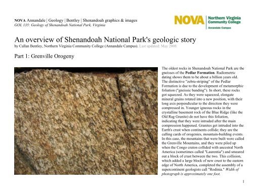
An overview of Shenandoah National Park's geologic story
An overview of Shenandoah National Park's geologic story
An overview of Shenandoah National Park's geologic story

You also want an ePaper? Increase the reach of your titles
YUMPU automatically turns print PDFs into web optimized ePapers that Google loves.
NOVA <strong>An</strong>nandale | Geology | Bentley | <strong>Shenandoah</strong> graphics & images<br />
GOL 135: Geology <strong>of</strong> <strong>Shenandoah</strong> <strong>National</strong> Park, Virginia<br />
<strong>An</strong> <strong>overview</strong> <strong>of</strong> <strong>Shenandoah</strong> <strong>National</strong> <strong>Park's</strong> <strong>geologic</strong> <strong>story</strong><br />
by Callan Bentley, Northern Virginia Community College (<strong>An</strong>nandale Campus). Last updated: May 2008<br />
Part 1: Grenville Orogeny<br />
The oldest rocks in <strong>Shenandoah</strong> <strong>National</strong> Park are the<br />
gneisses <strong>of</strong> the Pedlar Formation. Radiometric<br />
dating shows them to be about a billion years old.<br />
The distinctive "zebra-striping" <strong>of</strong> the Pedlar<br />
Formation is due to the development <strong>of</strong> metamorphic<br />
foliation ("gneissic banding"). In short, these rocks<br />
got squeezed. As they were squeezed, elongate<br />
mineral grains rotated into a new position, with their<br />
long axis perpendicular to the direction they were<br />
compressed in. Younger igneous rocks in the<br />
crystalline basement rock <strong>of</strong> the Blue Ridge (like the<br />
Old Rag Granite) do not have this foliation,<br />
indicating that they were intruded after the main<br />
compression happened. Granites get intruded into the<br />
Earth's crust when continents collide; they are the<br />
calling cards <strong>of</strong> orogenies, mountain-building events.<br />
In this case, the mountains that were built were called<br />
the Grenville Mountains, and they were piled up<br />
when the Congo craton collided with ancestral North<br />
America (sometimes called "Laurentia") and smeared<br />
out a block <strong>of</strong> crust between the two. This collision,<br />
which added a large block <strong>of</strong> new crust to the eastern<br />
edge <strong>of</strong> North America, completed the assembly <strong>of</strong> a<br />
supercontinent geologists call "Rodinia." Width <strong>of</strong><br />
photograph is approximately one foot.<br />
1
<strong>An</strong> illustration <strong>of</strong> the difference in texture between a granite and a granite-gneiss. Granite-gneisses<br />
(B) have foliation, indicating that they have been deformed after the original granite (A) cooled. In<br />
the Pedlar Formation, we see a lot <strong>of</strong> granite-gneiss, while the Old Rag Formation is dominantly<br />
granite. The Pedlar has been around longer (it is older), meaning that it has more opportunity to be<br />
squeezed by the mountain-building processes <strong>of</strong> the Grenville Orogeny. The Old Rag granites, on<br />
the other hand, were inserted into the crust rather later in the Grenville Orogeny, and so did not have<br />
the same opportunity to be deformed as the older Pedlar Formation.<br />
2
The Old Rag granite is not as foliated as the Pedlar<br />
Formation, indicating that it was intruded into the<br />
Grenvillian crust after the bulk <strong>of</strong> the compressional<br />
deformation had ceased. Note the presence <strong>of</strong> blue<br />
quartz: quartz containing inclusions <strong>of</strong> the titaniumrich<br />
minerals ilmenite and rutile. Blue quartz is an<br />
indication these rocks have been metamorphosed<br />
twice: once during the Grenville Orogeny, and again<br />
later during the Appalachian Orogeny. Width <strong>of</strong><br />
photo is about six inches.<br />
3
Part 2: weathering and erosion <strong>of</strong> the Grenville Mountains<br />
After the Grenville Orogeny ceased, the Earthsurface<br />
processes <strong>of</strong> weathering and erosion began<br />
wearing away at the uplifted mountains, dragging<br />
them down pebble by pebble, sand-grain by sandgrain.<br />
A discontinuous group <strong>of</strong> sedimentary rocks<br />
that resulted from this erosion is preserved in patches<br />
above the Pedlar and Old Rag Formations. These<br />
sediments, <strong>of</strong> the Swift Run Formation, are<br />
interpreted as steam valleys filled with sediment,<br />
draining the Grenville range. They are<br />
compositionally immature, with large, angular grains<br />
<strong>of</strong> feldspar. Width <strong>of</strong> photograph is approximately six<br />
inches.<br />
4
Part 3: Rifting <strong>of</strong> Rodinia, and eruption <strong>of</strong> the Catoctin flood basalts.<br />
The modern Afar Triangle region <strong>of</strong> Ethiopia (East Africa) provides an analogue for<br />
what Rodinia may have looked like during the rifting event which created the<br />
Iapetus Ocean basin. Normal faulting results in a down-dropped central basin (the<br />
"Great Rift Valley"). From its source in the mantle, lava travells upwards through<br />
the crust along a plumbing-like series <strong>of</strong> fractures. Fresh lava (which cools to form<br />
the igneous rock basalt) floods out over the surface. The same thing happened in<br />
<strong>Shenandoah</strong> about 700 million years ago. Some estimates put the volume <strong>of</strong> lava<br />
extruded at around 1000 cubic miles! We call it the Catoctin Formation.<br />
Eventually, the rift valley shown will flood with ocean water, and be a skinny,<br />
narrow sea much like the modern Gulf <strong>of</strong> Aden or the Red Sea. This body <strong>of</strong> water<br />
will widen and widen (sea floor spreading) and eventually attain the dimensions <strong>of</strong><br />
a proper ocean basin. In <strong>Shenandoah</strong>, the lavas remind us that Rodinia was rifting<br />
apart, and opening up the brand-new Iapetus Ocean basin. Modified from a Google<br />
Earth image.<br />
5
Mike Nelson obligingly points out a thick, tabular zone <strong>of</strong> dark rock cutting<br />
across an area <strong>of</strong> much lighter rock. This distinctive stripe is a dike <strong>of</strong> the<br />
Catoctin Formation, cutting across the older gneiss <strong>of</strong> the Pedlar Formation.<br />
These feeder dikes were "plumbing" conduits that led from sources near the<br />
mantle upward to the surface <strong>of</strong> Rodinia. A build-up <strong>of</strong> excess heat beneath<br />
the Rodinian supercontinent caused it to break apart (much like excess heat<br />
in a microwaved potato will cause it to break apart). Stretching occurred in a<br />
WNW-ESE direction, causing fractures to open up that were oriented<br />
perpendicular to that, roughly NNE-SSW. These fractures popped open, and<br />
released pressure on the hot mantle rocks far below. This decompression<br />
allowed the ultramafic mantle rocks to partially melt, giving rise to a maficcomposition<br />
magma which gurgled upwards towards the surface. When it<br />
reached the surface, it spilled out over the landscape in a fissure eruption <strong>of</strong><br />
the sort we see today in East Africa's Great Rift Valley.<br />
6
A close-up <strong>of</strong> the contact between the granite-gneiss host rocks <strong>of</strong> the Pedlar<br />
Formation (right) and the dark, fine-grained basaltic feeder dikes <strong>of</strong> the<br />
Catoctin Formation (left), exposed near Little Devil's Staircase overlook on<br />
Skyline Drive. Quarter for scale.<br />
7
A huge dike <strong>of</strong> metamorphosed basalt, cutting through the Pedlar<br />
Formation just north <strong>of</strong> Marys Rock Tunnel (left) on Skyline Drive. This<br />
dike is one <strong>of</strong> many feeder dikes which acted as conduits bringing molten<br />
rock to the surface (see above), but it is the largest that can be seen along<br />
Skyline Drive. Note the columnar jointing that extends perpendicular to the<br />
walls <strong>of</strong> the dike (see discussion in the next two photos below), indicating<br />
that cooling started at the edges and then worked its way into the warm<br />
center. Photo by Greg Beaudoin. Width <strong>of</strong> dike is about eight feet.<br />
9
Weathered feeder dikes on Old Rag<br />
Mountain's "Summit Trail." Because<br />
meta-basalt is less stable than the<br />
granite it cuts across, it weathers<br />
away, leaving narrow slot-like areas.<br />
Width <strong>of</strong> dikes is about 3 or 4 feet.<br />
10
When basaltic lava erupts onto the surface <strong>of</strong> the<br />
Earth, as it did during the extrusion <strong>of</strong> the Catoctin<br />
Formation, the lava loses heat quickly to the<br />
atmosphere. This loss <strong>of</strong> heat cools the lava down,<br />
and lets it solidify into igneous rock. As it cools, the<br />
basalt contracts in volume, for the reason that hot<br />
things are less dense than cold things. As it cools, it<br />
contracts equally across the surface <strong>of</strong> the flow, and<br />
forms columnar jointing. These examples are on the<br />
Limberlost Trail, south <strong>of</strong> Skyland. Columns are<br />
about one foot in diameter.<br />
11
A cross-sectional view <strong>of</strong> the columns created when<br />
basalt contracts and experiences columnar jointing.<br />
This "soccer ball" pattern appears as the cooling rock<br />
contracts equally in every direction, resulting in<br />
evenly-spaced, equal-angle (about 120º) cracks<br />
opening up at the surface, and then extending down<br />
into the flow. The same pattern is seen as drying mud<br />
contracts and cracks into similar polygonal shapes.<br />
As above, the outcrop is on the Limberlost Trail,<br />
south <strong>of</strong> Skyland. Pencil for scale.<br />
12
Some other examples <strong>of</strong> columnar jointing: the<br />
Giant's Causeway, County <strong>An</strong>trim, Northern Ireland<br />
(as depicted on the cover <strong>of</strong> the Led Zeppelin album<br />
"Houses <strong>of</strong> the Holy"), and Devils Tower, Wyoming.<br />
13
<strong>An</strong>other thing that erupting lava does is de-gas. Lava,<br />
like soda, is a solution <strong>of</strong> many components. Several<br />
varieties <strong>of</strong> gas are typically dissolved in magma.<br />
When the magma makes it to the surface <strong>of</strong> the Earth<br />
in an eruption (thereby dropping the name magma<br />
and becoming lava instead), it <strong>of</strong>ten loses some <strong>of</strong><br />
these gases. The gases, which were stable under<br />
higher pressures deep in the Earth, spontaneously<br />
bubble out <strong>of</strong> solution when the pressure is released.<br />
Your soda will do the same thing when you pop the<br />
top: suddenly carbon dioxide (CO2) which had been<br />
stable under pressure, now bubbles out <strong>of</strong> solution,<br />
making s<strong>of</strong>t drinks "s<strong>of</strong>t." CO2 is also one <strong>of</strong> the most<br />
common volcanic gases, though water vapor is even<br />
more common. When the lava starts bubbling, some<br />
<strong>of</strong> the bubbles can be caught and preserved as little<br />
Swiss-Cheese-style holes in the rock. Geologists call<br />
these holes vesicles, and they are readily seen in<br />
these two hand-samples from the NVCC <strong>An</strong>nandale<br />
Geology Lab. Width <strong>of</strong> photograph is approximately<br />
eight inches.<br />
14
Here are some vesicles preserved in the Catoctin<br />
meta-basalt flows. These bubbles tell us that the lava<br />
was at sufficiently low pressures to allow degassing<br />
when it cooled. Width <strong>of</strong> photograph is about four<br />
inches.<br />
15
When vesicles get filled in (usually by hydrothermal<br />
precipitation <strong>of</strong> soluble minerals by groundwater),<br />
amygdules form. These colorful amygdules are<br />
exposed in boulders <strong>of</strong> the Catoctin Formation along<br />
the Limberlost Trail, south <strong>of</strong> Skyland. They show<br />
concentric zonation, indicating their growth pattern:<br />
being precipitated around the edges <strong>of</strong> the vesicle<br />
hole first, then slowly filling in the rest <strong>of</strong> the void.<br />
The term amygdule comes from the Latin term for<br />
"almond", referring to their shapes: These ellipsoidal<br />
little nuggets first seemed almost like almonds<br />
studding a dessert pastry. Width <strong>of</strong> photograph<br />
(foreground) is about three feet.<br />
16
Some <strong>of</strong> the lava <strong>of</strong> the Catoctin eruptions flowed<br />
over streambeds and other low-lying areas where bits<br />
<strong>of</strong> older rocks were lying in its path. Like pizza<br />
dough dropped on a pile <strong>of</strong> raisins will pick up some<br />
<strong>of</strong> the raisins in its sticky bulk, so too will lava pick<br />
up any stray clasts that are in its way. Here we see<br />
clasts <strong>of</strong> the Swift Run Formation (purple and white)<br />
caught up in the matrix <strong>of</strong> Catoctin lava (here<br />
metamorphosed to the green-colored mineral<br />
epidote). The angular shape <strong>of</strong> the Swift Run<br />
fragments show that they haven't moved very far in<br />
the hot lava -- otherwise they would have thermally<br />
eroded to rounder shapes, as will an ice cube left in a<br />
beverage for too long. Thus, we call this a volcanic<br />
breccia (an Italian word, it rhymes with "getcha").<br />
Width <strong>of</strong> photograph is about one foot.<br />
17
Location <strong>of</strong> pillow basalts, bread-loaf-shaped<br />
structures that form only when lava erupts under<br />
water. Map from Lukert and Mitra (1986):<br />
"Extrusional environments <strong>of</strong> part <strong>of</strong> the Catoctin<br />
Formation," Geological Society <strong>of</strong> America<br />
Centennial Field Guide, Southeastern Section.<br />
18
It wasn't just 24-hour eruptions, 7 days a week,<br />
during the extrusion <strong>of</strong> the Catoctin flood basalts.<br />
Rather, some evidence in the Park shows us that there<br />
were extended periods <strong>of</strong> calm amid all the volcanic<br />
chaos. This outcrop, at Signal Knob Overlook<br />
(Milepost 5.7) shows us a streambed conglomerate,<br />
sandwiched between two Catoctin lava flows. The<br />
<strong>geologic</strong> <strong>story</strong> imparted by such an arrangement <strong>of</strong><br />
rocks is: (1) lava erupted, (2) things calmed down<br />
enough for a stream to establish itself draining along<br />
the top <strong>of</strong> the lava flow, carrying along pebbles and<br />
sand, (3) another eruption buried the stream under yet<br />
more lava. Width <strong>of</strong> photograph is about six inches.<br />
19
A view to the south, looking at Stony Man<br />
Mountain. Shenadoah's answer to New Hampshire's<br />
Old Man <strong>of</strong> the Mountain, Stony Man is thought by<br />
imaginative folks to look like a reclining face,<br />
viewed in pr<strong>of</strong>ile. It turns out that the underlying<br />
Catoctin Formation's various members, stacked up in<br />
sequence, determine the nature <strong>of</strong> this "face". Steps<br />
occur between each <strong>of</strong> the eruptions <strong>of</strong> the flood<br />
basalt, and certain formations are more easily eroded<br />
than others (like the volcanic breccia -- seen in the<br />
above photograph -- which forms the strongly<br />
concave depression that is Stony Man's upper lip).<br />
20
A map-view image <strong>of</strong> the globe at the time Rodinia<br />
was breaking apart: notice in particular the orange<br />
areas, indicating Grenvillian mountain belts around<br />
the world. The Congo craton pulls away from North<br />
America (technically called "Laurentia" at this point)<br />
along with the Amazonia craton, opening up a long,<br />
skinny ocean: the Iapetus Ocean.<br />
21
Part 4: Passive margin sedimentation, and sea level rise<br />
Once Rodinia broke apart and the tectonic plate boundary moved <strong>of</strong>fshore<br />
(the mid-ocean ridge built up new oceanic crust on the floor <strong>of</strong> the Iapetus<br />
Ocean, and so progressively moved further and further out to sea), sea level<br />
rose and flooded ancestral North America (a.k.a. "Laurentia"). This rise in<br />
sea level deposited three distinct sedimentary formations which can be seen<br />
today in <strong>Shenandoah</strong> <strong>National</strong> Park, as well as the limestones which today<br />
make up the floor <strong>of</strong> the <strong>Shenandoah</strong> Valley to the west. Collectively called<br />
the Chilhowee Group, these sediments consist <strong>of</strong>: stream and river<br />
conglomerates and sandstones (Weverton Formation), lagoonal muds<br />
(Hampton Formation), and beach sands (Erwin Formation). This is a shot <strong>of</strong><br />
the conglomerate at the base <strong>of</strong> the Weverton Formation. Pen for scale.<br />
22
Here's another shot <strong>of</strong> a more "mature" (quartz-rich)<br />
area <strong>of</strong> the Weverton Formation. Remember that<br />
this had mud deposited atop it (Harpers Formation)<br />
and more mature quartz beach sand on top <strong>of</strong> that<br />
(<strong>An</strong>tietam Formation). On top <strong>of</strong> the uppermost<br />
beach sands were deposited limestones, but these<br />
limestones are not exposed in the Park today. A few<br />
miles further west, and a couple thousand feet lower<br />
in elevation, you can find them being etched into<br />
features like Luray Caverns. Width <strong>of</strong> photograph is<br />
about four inches.<br />
23
This sea-level rise is documented in <strong>Shenandoah</strong>'s<br />
classic example <strong>of</strong> a transgressive sequence <strong>of</strong><br />
sediments. The Chilhowee Group records a<br />
progressively retreating shoreline, because certain<br />
sediments only get deposited in certain areas (top).<br />
By analogy with modern sedimentation (a<br />
uniformitarian approach), we can determine that rise<br />
in sea level would shift all the sedimentary types<br />
("facies") above further inland. If our intrepid<br />
Cambrian SCUBA diver were to sit still as sea level<br />
rose (bottom), he would find himself buried in<br />
sediments representing further and further <strong>of</strong>fshore<br />
environments, until nothing clastic (& therefore landderived)<br />
was left, and so carbonates like limestone<br />
would cap <strong>of</strong>f the sequence. This incursion <strong>of</strong> sea<br />
level over the margin <strong>of</strong> the continent was known as<br />
the Sauk Sea. (The Sauk Sea, therefore, can be<br />
thought <strong>of</strong> as that portion <strong>of</strong> the Iapetus Ocean which<br />
was overtop <strong>of</strong> North American continental crust.)<br />
24
Scanning electron photomicrographs <strong>of</strong> sand grains deposited in the<br />
Sauk Sea show extreme rounding and "frosting" (small-scale<br />
pitting) on the surface <strong>of</strong> the grain. These features indicate the<br />
sediments were strongly worked by the wind before finally being<br />
deposited by water. It is thought that wind would have been a much<br />
more dominant force in physical weathering during the Proterozoic<br />
and Cambrian because <strong>of</strong> the absence <strong>of</strong> land vegetation then. (We<br />
know that the sediments were ultimately deposited by water because<br />
<strong>of</strong> the presence <strong>of</strong> aquatic ripple marks in the sediments, as well as<br />
trilobite fossils.)<br />
25
So our overall stack <strong>of</strong> rock layers in <strong>Shenandoah</strong> <strong>National</strong> Park looks something like<br />
this in cross-section. Redrawn from Gathright, 1976.<br />
26
Part 5: Deformation and metamorphism due to the Alleghenian Orogeny<br />
The final phase <strong>of</strong> the Alleghenian Orogeny (sometimes called "the" Applachian Orogeny) represented as a schematic cross section. As the Iapetus<br />
Ocean closed due to subduction, it grew narrower and narrower. Eventually it closed to nothing, and Africa (Gondwana) and North America<br />
(Laurasia) collided, raising up a series <strong>of</strong> mountains and completing the assembly <strong>of</strong> a second supercontinent, Pangea.<br />
27
All older rocks were both metamorphosed<br />
(chemically altered under conditions <strong>of</strong> elevated<br />
temperature and pressure) and structurally deformed<br />
in an intense mountain-building event called the<br />
Appalachian Orogeny, which occurred about 300<br />
million years ago. During this orogeny, the basalt <strong>of</strong><br />
the Catoctin Formation was metamorphosed into a<br />
greenstone. Greenstones are metamorphic rocks<br />
characterized by a large amount <strong>of</strong> the green-colored<br />
metamorphic minerals chlorite and epidote. The<br />
epidote is a pistachio-green, whereas the chlorite is<br />
usually forest-green.<br />
The second thing we can see in this picture is that our<br />
perfect 120º-120º-120º "soccer ball" pattern to the<br />
columnar joining no longer holds. The Catoctin's<br />
cooling columns have been deformed. Now our<br />
columns have been squashed (from top to bottom in<br />
this picture), resulting in angles <strong>of</strong> ~140º (more<br />
obtuse) and ~110º (more acute). Outcrop is on the<br />
Limberlost Trail, south <strong>of</strong> Skyland. Large central<br />
column is about one foot wide (left to right).<br />
28
These ones are even more squashed: ~145º and ~90º<br />
angles show us these columns are not as equiangluar<br />
as they must have been when they formed. Hence,<br />
they've been deformed, likely during the Appalachian<br />
Orogeny. As above, the direction <strong>of</strong> compression is<br />
from the top <strong>of</strong> the photo towards the bottom,<br />
resulting in extension from left to right. Outcrop is on<br />
the Limberlost Trail, south <strong>of</strong> Skyland. Large central<br />
column is about one foot wide (left to right).<br />
29
During the Alleghenian Orogeny, about 300 million<br />
years ago, the ancient crystalline and metasedimentary<br />
rocks <strong>of</strong> the Blue Ridge province were<br />
broken <strong>of</strong>f <strong>of</strong> the main part <strong>of</strong> the North American<br />
crust and shoved up and to the west over much<br />
younger sedimentary rocks. In general, the structure<br />
<strong>of</strong> the Blue Ridge Province is a vast, overturned<br />
fold, lopsided towards the west. Furthermore, the<br />
fold is detached from its roots in the "basement" rock<br />
<strong>of</strong> the east coast, and has travelled along a zinger <strong>of</strong> a<br />
fault, the Blue Ridge Thrust Fault, from an original<br />
position somewhere further east. Note that the Blue<br />
Ridge mountains are merely the westernmost portion<br />
<strong>of</strong> the Blue Ridge province, which actually extends<br />
much further east.<br />
30
A delicious analogy for the Blue Ridge Thrust Fault.<br />
I baked a chocolate & peanut butter cake last week.<br />
Yesterday, I baked a carrot cake. The carrot cake is<br />
younger; the chocolate cake is older. Then I shoved<br />
the older cake on top <strong>of</strong> the younger cake by pushing<br />
sideways (A). Travelling along a layer <strong>of</strong> icing, the<br />
older chocolate cake moved up and over the younger<br />
carrot cake. The surface <strong>of</strong> contact between the two is<br />
the Blue Ridge Thrust Fault, shown as a dotted line<br />
(B). Arrows show relative motions <strong>of</strong> the two cakes.<br />
This thrust-faulted cake was served at the NOVA-<br />
<strong>An</strong>nandale end-<strong>of</strong>-semester party for the<br />
Mathematics, Science and Engineering Department,<br />
May 2006.<br />
31
The overall sequence <strong>of</strong> events in <strong>Shenandoah</strong> <strong>National</strong> Park, as illustrated by Gathright<br />
(1976). From top to bottom:<br />
Extrusion <strong>of</strong> lava flows.<br />
Deposition <strong>of</strong> Weverton Formation conglomerates and sand.<br />
Deposition <strong>of</strong> Harpers Formation mud.<br />
Deposition <strong>of</strong> <strong>An</strong>tietam Formation barrier island sands.<br />
Deposition <strong>of</strong> Tomstown Formation and other Cambrian/Ordovician carbonates (limestones).<br />
Folding and faulting <strong>of</strong> all rock units during Alleghenian Orogeny.<br />
32
Symptoms <strong>of</strong> the Alleghenian Orogeny expressed as a cross-section: felsic intrusions (e.g. granite, generated through partial melting <strong>of</strong> pre-existing<br />
rocks), deformation (folding and faulting), and metamorphism. Slices <strong>of</strong> oceanic crust (ophiolites) may also be present.<br />
33
Part 6: Uplift and erosion<br />
After the Alleghenian Orogeny, supercontinent-rifting ensued again (this<br />
time Pangea broke apart, and the Atlantic Ocean was born). The<br />
Appalachian mountain range was abandoned by the forces <strong>of</strong> tectonic<br />
uplift, and left to erosion and weathering. These surficial forces had<br />
their way with the great mountain range, reducing it to its roots.<br />
A satellite photo (false-color image) <strong>of</strong> the Blue Ridge Mountains in<br />
<strong>Shenandoah</strong> <strong>National</strong> Park (below, right), and also the distinct form <strong>of</strong><br />
Massanutten Mountain in the <strong>Shenandoah</strong> ("Great") Valley (center).<br />
"Warm" colors represent high elevations; lower elevations are green. The<br />
texture <strong>of</strong> the Blue Ridge is markedly different from the mountains to its<br />
northwest. This textural difference is entirely due to the rocks the<br />
respective provinces are made <strong>of</strong>. The Blue Ridge is hewn from<br />
metamorphosed sedimentary and igneous rocks, whereas the Valley and<br />
Ridge province is a series <strong>of</strong> folded sedimentary layers, only lightly<br />
metamorphosed. Note also the pronounced meanders <strong>of</strong> the North and<br />
South forks <strong>of</strong> the <strong>Shenandoah</strong> River, on either side <strong>of</strong> Massanutten.<br />
(NASA image)<br />
34
Here's a look at the subsurface geology <strong>of</strong> the <strong>Shenandoah</strong> Valley,<br />
to the west <strong>of</strong> the Blue Ridge. A line <strong>of</strong> cross-section<br />
schematically "slices open" the Earth, revealing the structure <strong>of</strong><br />
the rock layers underlying the Blue Ridge and Massanutten<br />
Mountain. Massanutten is a structural syncline, a down-folded<br />
package <strong>of</strong> rocks. Certain rocks (yellow) like sandstone are<br />
resistant to weathering, and form resistant ridges <strong>of</strong> rock. Others,<br />
like limestone and shale (blues, pink, purple, & green) are less<br />
resistant, and are easily eroded down into topographic valleys.<br />
The rocks <strong>of</strong> the Blue Ridge are represented here with a peach<br />
color, and shown shoved bodily overtop <strong>of</strong> younger layers along<br />
the Blue Ridge Thrust Fault. Modified from a Google Earth<br />
image.<br />
35
Mountain ranges weather away after tectonic<br />
uplift has ceased, until eventually topographic<br />
relief is at a minimum, and only the symptoms<br />
<strong>of</strong> a mountain belt remain (folds, faults,<br />
regionally-metamorphosed rocks, felsic<br />
intrusive igenous rocks. The Appalachian<br />
Mountains we see today are largely due to<br />
differential weathering <strong>of</strong> the rocks beneath,<br />
with the Blue Ridge most resistant to<br />
weathering (and thus being the highest-elevation<br />
feature in the region).<br />
<strong>Shenandoah</strong> field course | Callan Bentley home<br />
36