Tacklers Trail 6pp Lft_v3.qxd - Visit Lancashire
Tacklers Trail 6pp Lft_v3.qxd - Visit Lancashire
Tacklers Trail 6pp Lft_v3.qxd - Visit Lancashire

Create successful ePaper yourself
Turn your PDF publications into a flip-book with our unique Google optimized e-Paper software.
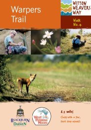
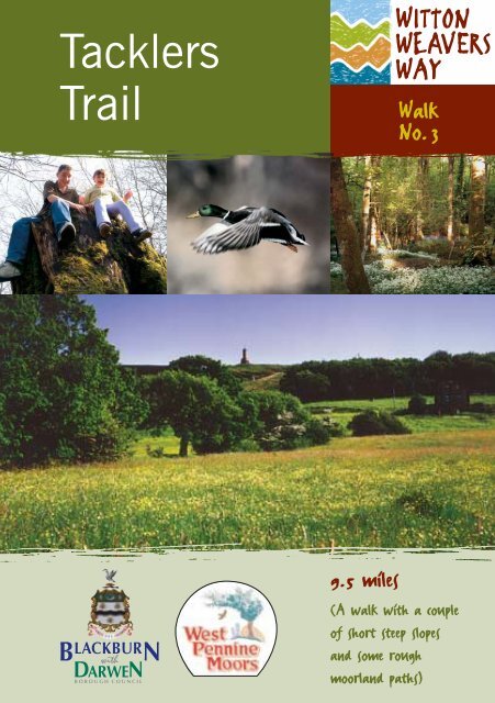
<strong>Tacklers</strong><br />
<strong>Trail</strong><br />
Walk<br />
No.3<br />
9.5 miles<br />
(A walk with a couple<br />
of short steep slopes<br />
and some rough<br />
moorland paths)
WALK<br />
3 TACKLERS TRAIL 9.5 miles (moderate wi<br />
1. Sunnyhurst <strong>Visit</strong>or<br />
Centre<br />
The Warpers <strong>Trail</strong> forms part of the long distance Witton Weavers Way.<br />
This walk combines woodlands, moorland and spectacular views to make this trail<br />
well worth the effort!<br />
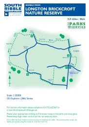
You are strongly advised to use these walk details in conjunction with OS Explorer map<br />
No. 287, West Pennine Moors. Stout boots are recommended, as parts of this walk can<br />
become muddy in wet weather.<br />
START: Sunnyhurst Wood <strong>Visit</strong>or Centre, a short walk down from Earnsdale Road,<br />
Darwen<br />
PUBLIC TRANSPORT: 1 mile from Darwen town centre, alight at Hollins Grove Street<br />
PARKING: On Earnsdale Road, off A666. 1 mile from junction 4 M65<br />
ALTERNATIVE PARKING AND START POINTS (SEE OS MAP FOR EXACT LOCATIONS):<br />
• Slipper Lowe car park- 1km from Roddlesworth GR 664203<br />
• Car park off Belmont Road, A675 - 2km from Roddlesworth GR 665191<br />
• Sunnyhurst car park - at top of Earnsdale Road GR 679225<br />
Sunnyhurst Wood was acquired<br />
by public subscription in 1902<br />
to commemorate the coronation<br />
of King Edward VII.<br />
The <strong>Visit</strong>or Centre 1 , in the<br />
former gamekeeper's cottage<br />
offers exhibitions, activities and<br />
information.<br />
The charming Olde England<br />
Kiosk (refreshments available)<br />
was built in 1911 to<br />
commemorate the coronation of<br />
King George V<br />
16–17<br />
From the <strong>Visit</strong>or Centre walk up<br />
into the wood, following<br />
Sunnyhurst brook, past the stone<br />
bridges, and on past the<br />
bandstand. Continue up the<br />
valley, emerging from the wood<br />
by an iron gate, at the corner of<br />
Earnsdale Reservoir.<br />
17–18<br />
Turn right up the track eventually<br />
emerging onto Tockholes Road,<br />
built by Eccles Shorrock in the<br />
1840s to link the village with<br />
Darwen. Eccles Shorrock is best<br />
known today for the 300 foot<br />
Venetian campanile chimney of<br />
India Mill, Darwen. Turn left and<br />
after 100 yards take the footpath<br />
on the right down into the wood.<br />
As the Roddlesworth Upper<br />
Reservoir 2 comes into view,<br />
follow the path round to the left.<br />
2. Roddlesworth Upper Reservoir<br />
Mallard and goldeneye ducks<br />
can be seen on the reservoirs,<br />
with the occasional great crested<br />
grebe or tufted duck in winter 3 .<br />
The coniferous plantations have<br />
rowan, oak and birch saplings<br />
along their edges to provide<br />
varied wildlife habitats.<br />
In about 100 yards a footpath<br />
crosses the track, turn right here<br />
and left at the reservoir. Follow<br />
the path round by a fence then<br />
a wall to cross the bridge over<br />
Rocky Brook, the local name of<br />
the River Roddlesworth.<br />
18–19<br />
Continue alongside the brook<br />
keeping to the lower path at a<br />
fork. Go through the iron gate<br />
and cross the stone bridge,<br />
known as Halliwell Fold Bridge 4 .<br />
Continue up the track with the<br />
brook now on your right.<br />
This junction of lanes was once<br />
a busy road linking Abbey<br />
Village, Tockholes and<br />
Hollinshead Hall with many<br />
dwellings. The ruins of<br />
Halliwell Fold Farm once<br />
supplied chain horses to help<br />
3. Spot the birdlife amidst<br />
Reservoir country
th a couple of short steep inclines &some rough m<br />
To Abbey<br />
Village<br />
Crown copyright. All rights reserved.<br />
Blackburn with Darwen Borough Council.<br />
Licence number L.A. 077178/00/02<br />
To Tockholes<br />
Village<br />
Roddlesworth<br />
18<br />
SLIPPER<br />
LOWE<br />
P<br />
A675 BELMONT ROAD<br />
ROYAL ARMS<br />
P<br />
RODDLESWORTH<br />
CAFÉ & INFO<br />
POINT<br />
BUS<br />
TERMINAL<br />
19<br />
RUINS OF<br />
HOLLINSHEAD<br />
HALL<br />
P<br />
20<br />
17<br />
21<br />
RUINS OF HIGHER<br />
PASTURE BARN FARM<br />
To<br />
Belmont<br />
SUNNYHURST<br />
WOOD<br />
VISITOR<br />
CENTRE<br />
To Blackburn<br />
& M65, Junct. 4<br />
P Sunnyhurst<br />
LYCHGATE<br />
HOTEL<br />
DARWEN<br />
TOWER<br />
24<br />
16<br />
START<br />
Darwen Moor<br />
EARNSDALE ROAD<br />
LORD’S<br />
HALL<br />
A666 BLACKBURN ROAD<br />
TOCKHOLES ROAD<br />
23<br />
Turton Moor<br />
A666 DUCKWORTH STREET<br />
BOLD<br />
VENTRE<br />
PARK<br />
To Darwen<br />
RUINS OF<br />
TOP O’ TH’ BROW<br />
Whitehall<br />
Park<br />
2
oorland paths) WITTON WEAVERS WAY<br />
4. Halliwell Fold Bridge,<br />
Roddlesworth<br />
Cadshaw<br />
Valley<br />
pull the heavy loads of coal up<br />
the steep gradient to Tockholes<br />
from Withnell railway station<br />
to fuel the local mill.<br />
Wild flowers to look out for<br />
include bluebells 5 and lesser<br />
celandine in spring, wood<br />
sorrel, pignut, golden saxifrage<br />
and clumps of wood rush, the<br />
blue devil's bit scabious, wood<br />
sage and red campion. Birds to<br />
spot include grey wagtail and<br />
chaffinch.<br />
The track climbs steadily as it<br />
leaves the brook, eventually<br />
levelling off at a clearing. Go<br />
straight on here through a gate.<br />
The road to the left here is<br />
known as Slipper Lowe and<br />
leads to the main road that<br />
passes through Tockholes from<br />
Blackburn to Bolton. At the end<br />
of Slipper Lowe is a picnic site,<br />
a convenient place for parking<br />
and an alternative start point.<br />
5. Bluebells<br />
19–20<br />
Continue ahead, following the<br />
track down the hill alongside the<br />
wall. Great Hill is prominent to<br />
the right. Go straight through the<br />
ruins of Hollinshead Hall,<br />
climbing the track to the left of<br />
the wooden fence.<br />
Hollinshead Hall was the<br />
manor house of Tockholes and<br />
what remains are the ruins of<br />
the 18th century hall, stables<br />
and farm buildings. There has<br />
been a hall on the site since the<br />
14thcentury. The last owner<br />
was Eccles Shorrock who<br />
allowed the buildings to fall<br />
into disrepair. The site was<br />
demolished in 1911 by<br />
Liverpool Corporation who<br />
needed the stone to build a wall<br />
to keep sheep out of the newly<br />
planted woods around the<br />
reservoir.<br />
The wellhouse 6 (Wishing Well<br />
or Holy Well) still stands. Five<br />
springs of water meet here and<br />
they have legendary healing<br />
properties for eyes.<br />
On joining Tockholes Road turn<br />
right. After 500 yards take the<br />
green lane that carries straight<br />
on where the road bends sharply<br />
to the right. (The car park to the<br />
right is another possible starting<br />
point)<br />
20–21<br />
When the wall on your left ends,<br />
turn left up an unfenced track.<br />
You climb steadily, going over a<br />
stile by a gate, with the ruins of<br />
Higher Pasture Barn Farm on<br />
the right. As the track climbs<br />
sharply to the left, take the<br />
rough path that continues<br />
climbing straight ahead. At the<br />
crest of the hill you may wish to<br />
rest a while, on the bench<br />
dedicated to Vic Ryan, former<br />
president of Blackburn Rambling<br />
Association who often led walks<br />
through this countryside.<br />
Miners built most of the tracks<br />
over Darwen Moor and the<br />
plateau has the remains of many<br />
filled-in mine shafts, spoil heaps<br />
and even the bed of an old steam<br />
engine. There were no less than<br />
21 pits with a further dozen or so<br />
scattered around the moor where<br />
poor grade coal was mined for<br />
over 300 years. In the<br />
19thcentury the coal was used to<br />
6. Hollinshead Hall: Haunted Wellhouse<br />
fire the steam engines of the two<br />
village mills. From these pits<br />
originates the local folklore of<br />
"treacle mines". The treacle being<br />
the sticky tar often found in the<br />
coal seam when the coal is young<br />
and not yet solid.<br />
21–22<br />
Cross the wall and continue<br />
straight ahead along the track,<br />
keeping a low wall on your right.<br />
The track swings right then left<br />
and you will meet a stream on<br />
your right, which soon becomes a<br />
culvert. Continue down the valley<br />
and in approximately 1 1/2 miles<br />
you will pass the ruined Top o’ th’<br />
Brow farm on your right.
7. Darwen Tower View<br />
This is the Cadshaw Valley, in<br />
which up to 200 people lived<br />
and worked in the 19th<br />
century, before the land was<br />
taken over by Liverpool<br />
Corporation for water supply<br />
works. In the distance look out<br />
for Peel Tower on Holcombe<br />
Moor, standing at 128 feet<br />
high. The monument was<br />
erected in 1852 in honour Sir<br />
Robert Peel, a local townsman,<br />
at a total cost of £965.<br />
22–23<br />
Follow the track and in a short<br />
while you will see a ruin and a<br />
solitary tree up on your left.<br />
Climb up the field to cross the<br />
stile next to the ruin. Carry<br />
straight on to climb a stile in a<br />
wall. Cross the field diagonally,<br />
keeping both walls equally<br />
distant. The India Mill chimney<br />
will appear in the distance. This<br />
is now your line. Darwen Tower<br />
will be seen to your left.<br />
Climb the stile at the top of the<br />
conifer plantation, and follow<br />
the footpath down, alongside<br />
the fence. Climb the stile and<br />
continue along the track over<br />
open ground. Climb the stile<br />
and follow the path over rough<br />
ground alongside the fence. A<br />
modern white house, know<br />
locally as Lord’s hall, will<br />
appear ahead and you<br />
eventually emerge onto its drive.<br />
23–24<br />
Turn right down the drive and<br />
take the path on the left just<br />
before the gateway. Continue up<br />
along the fence. Darwen Tower 7<br />
will come into view then take<br />
the left fork of the path. Shortly<br />
afterwards, take the right fork<br />
and continue onto the tower.<br />
The Jubilee Tower, to give its<br />
correct name, was built in 1897<br />
by public subscription. It<br />
commemorated Queen<br />
Victoria's Diamond Jubilee and<br />
also celebrated the opening of<br />
Darwen Moor to the public<br />
after a long fight for access.<br />
From the top of the tower on<br />
clear days you can see as far as<br />
the Fylde coast, the Lake<br />
District and North Wales.<br />
24–16<br />
Turn right at the tower's<br />
triangulation point, taking the<br />
wide track that goes over the<br />
rounded hill, in the direction of<br />
distant Pendle Hill. Go over the<br />
brow, through a gate and<br />
continue down the track taking<br />
a left fork along a wall. Turn left<br />
at the Sunnyhurst Pub, with the<br />
Lychgate Hotel 8 on your left, (a<br />
former 16th century farmhouse)<br />
offering quality accommodation.<br />
8. Rambling over the Moors from the<br />
Lychgate Hotel<br />
Take the first right through the<br />
Lychgate 9 into the wood and<br />
then the right-hand fork.<br />
Continue down the hill turning<br />
right at the bandstand. Keep to<br />
the path on the right bank of<br />
the stream to return to the<br />
<strong>Visit</strong>or Centre.<br />
9. Sunnyhurst Lychgate and Cyclists<br />
USEFUL INFORMATION<br />
Blackburn Tourist Information<br />
Centre (01254) 53277 or<br />
www.tourism.blackburnworld.com<br />
Travel Centre (01254) 681120<br />
Sunnyhurst Wood <strong>Visit</strong>or Centre<br />
(01254) 701545 or 55423<br />
Olde England Kiosk (01254) 701530<br />
The Lychgate Hotel (01254) 775632<br />
Sunnyhurst Pub (01254) 873035
THE COUNTRY CODE<br />
• Enjoy the countryside and respect its life<br />
and work.<br />
• Guard against all risk of fire.<br />
• Fasten all gates.<br />
• Keep dogs under close control.<br />
• Keep to paths across farmland.<br />
• Avoid damage to fences, hedges and<br />
walls.<br />
• Leave livestock, crops and machinery<br />
alone.<br />
• Leave no litter.<br />
• Help to keep all water clean.<br />
NOTES FOR WALKERS<br />
ESSENTIAL KIT<br />
The OS Explorer No. 287<br />
(West Pennine Moors) provides<br />
excellent aid and information on<br />
all areas covered in this guide.<br />
(Ordnance Survey tel: 08456<br />
050505 / www.ordsvy.gov.uk)<br />
FURTHER INFORMATION<br />
If you are travelling to the start of the walk<br />
using public transport, please contact<br />
Blackburn Travel and Local Information<br />
Centre. Tel: 01254 681120.<br />
• Protect wildlife, plants and trees.<br />
• Go carefully on country roads.<br />
• Make no unnecessary noise.<br />
Blackburn Central Railway Station<br />
(Enquiries). Tel: 08457 484950.<br />
For information on local attractions, events,<br />
places of interest and accommodation,<br />
please contact Blackburn Tourist<br />
Information Centre. Tel: 01254 53277.<br />
Email: askus@blackburn.gov.uk<br />
Alternatively visit the Blackburn with<br />
Darwen website at:<br />
www.tourism.blackburnworld.com<br />
Blackburn with Darwen Countryside<br />
Services Office. Tel: 01254 691239<br />
for countryside information and events.<br />
Please note that every effort has been taken to ensure<br />
details are correct at the time of printing. Blackburn<br />
with Darwen Borough Council cannot accept<br />
responsibility for any errors or omissions, nor any<br />
consequence arising from use of the information.<br />
Reprinted March 2004 by Blackburn with Darwen Borough Council<br />
Marketing & Tourism Development and Countryside Services.<br />
Photos: Mike Tattersall, Blackburn with Darwen Borough Council