2: Hydrothermal ore deposits related to post-orogenic extensional ...
2: Hydrothermal ore deposits related to post-orogenic extensional ...
2: Hydrothermal ore deposits related to post-orogenic extensional ...

Create successful ePaper yourself
Turn your PDF publications into a flip-book with our unique Google optimized e-Paper software.
56<br />
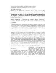
2.2. Tec<strong>to</strong>nostratigraphic units of high-grade<br />
metamorphic rocks of the Rhodope Massif<br />
The Rhodope Massif represents a large accretionary<br />
orogen that formed between the Srednogorie zone<br />
(underlain by European continental basement) and<br />
the present Aegean Sea. Complex nappe tec<strong>to</strong>nics<br />
and crustal thickening resulted from accretion of<br />
dominantly continental crustal material followed by<br />
P. Marchev et al. / Ore Geology Reviews 27 (2005) 53–89<br />
polyphase regional metamorphism and final structuring<br />
by major low-angle <strong>extensional</strong> faults. Metamorphism<br />
is dominantly of amphibolite-facies, with<br />
incipient migmatization in some areas, and local<br />
relics of high <strong>to</strong> ultra-high pressure eclogite facies<br />
metamorphism. A full structural and kinematic reconstruction<br />
has not yet been published. In the simplified<br />
map shown in Fig. 2, two major tec<strong>to</strong>nostratigraphic<br />
complexes, the Gneiss–Migmatite Complex and the<br />
Fig. 2. Schematic geological map of the Rhodope Massif showing the metamorphic dome structures and major intrusive and volcanic areas and<br />
dyke swarms. BD=Bratsigovo–Dospat; Br=Borovitsa; Db=Dambaluk; HBTB=High-Ba trachybasalts; IT=Iran Tepe; KE=Kirki–Esimi;<br />
KV=Kotili–Vitinia; KZ=Kaloticho–Zla<strong>to</strong>grad; Le=Levochevo; LFD=Loutros–Fere–Dadia; Lz=Lozen; Me=Mesta; Md=Madjarovo;<br />
Pe=Perelic; Pt=Petrota; SI=Sveti Ilia; Zd=Zvezdel; Yb=Yabalkovo. Plu<strong>to</strong>ns: CP=Central Pirin; RG=Rila granite; Sm=Smilian; Te=Teshevo;<br />
Vr=Vrondou; Xt=Xanthi; Yg=Yugovo. Compiled from Ricou et al. (1998), Arikas and Voudouris (1998), Harkovska et al. (1998a),<br />
Marchev et al. (1998a, b, and unpubl. data), Nedialkov and Pe-Piper (1998); Yanev et al. (1998a) and 1:100000 map of Bulgaria. Inset shows<br />
distribution of Palaeogene intrusive and volcanic rocks and con<strong>to</strong>urs of crustal thickness taken from Shanov and Kostadinov (1992).