Report - Assam: State Geology and Mineral Maps - India Water Portal
Report - Assam: State Geology and Mineral Maps - India Water Portal
Report - Assam: State Geology and Mineral Maps - India Water Portal

Create successful ePaper yourself
Turn your PDF publications into a flip-book with our unique Google optimized e-Paper software.
26 GEOLOGICAL SURVEY OF INDIA<br />
GSI Misc. Pub. 30 Pt. 4 Vol. 2(i)<br />
All the coal seams are interb<strong>and</strong>ed with dirt b<strong>and</strong>s.<br />
The coal seams are exposed at several places between the<br />
Namdang colliery in the west <strong>and</strong> the Tipang colliery in<br />
the east <strong>and</strong> are being mined at several collieries in between.<br />
The coal from the Makum Coalfield is of good<br />
quality with generally low to very low ash (1.9 to 5.9%),<br />
low moisture (1.9 to 3.9%) <strong>and</strong> high C.I. (17-24 B.S.S).<br />
Sulphur content is fairly high <strong>and</strong> lies between 1.53 <strong>and</strong><br />
5.43%. A total resource of 1327.00 million tonnes has<br />
been assessed for the Makum Coalfield up to 600m depth.<br />
Dilli-Jeypore Coalfield is the second most important<br />
coalfield of the northeastern region. The coal bearing<br />
Titak Parbat Formation of this coalfield extends continuously<br />
over a length of 33 km from Bimalpur Tea Garden<br />
in the southwest to Dhekiajuli in the northeast with an<br />
average width of 300 to 600 m. The coalfield is bounded<br />
by latitudes 27°04' N <strong>and</strong> 27°12' N <strong>and</strong> longitudes 95°15'<br />
E <strong>and</strong> 95°29’E. Two coal bearing horizons separated by<br />
barren arenaceous zone, 60 to 125 m thick have been established<br />
in this coalfield. The lower coal horizon is exposed<br />
along the Disang River whereas the upper one was<br />
intersected in the boreholes drilled in this coal field. The<br />
lower coal horizon, which is 70 to 90 m thick, contains<br />
three coal seams whereas the upper one with 100 to 113<br />
m thickness contain eight coal seams. All the coal seams<br />
in the Dilli-Jeypore coalfield are generally thin,<br />
impersistent <strong>and</strong> show number of splits with thickness<br />
varying from < 1 to 7.5 m. The basal seam is the thickest<br />
one with > 20 m thickness. The coals have moisture content<br />
of 2 to 8.3 % <strong>and</strong> ash content of 3 to 19.8%, which<br />
occasionally goes up to 37.6%. The total sulphur content<br />
varies from 1.3 to 13.5 % <strong>and</strong> the coal is non coking. A<br />
total resource of 54.02 million tonnes has been assessed<br />
for the Dilli-Jeypore coalfield up to 300 m depth.<br />
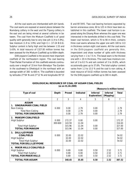
GEOLOGICAL RESOURCE OF COAL OF ASSAM COAL FIELDS<br />
(as on 01.04.2009)<br />
(Resource is million tonne)<br />
Type of coal Depth Proved Indicated Inferred Inferred Total<br />
Exploration) (Mapping)<br />
1 2 3 4 5 6 7<br />
ASSAM<br />
1. SINGRAIMARI COAL FIELD<br />
Non Coking 0-300 0.00 2.79 0.00 2.79<br />
Total Non Coking 0.00 2.79 0.00 2.79<br />
TOTAL FOR SINGRIMARI 0.00 2.79 0.00 2.79<br />
2. MAKUM COALFIELD<br />
High Sulphur 0-300 172.37 0.00 0.00 172.37<br />
300-600 143.59 11.04 154.63<br />
Total High Sulphur 315.96 11.04 0.00 327.00<br />
TOTAL FOR MAKUM 315.96 11.04 0.00 327.00<br />
3. DILLI-JEYPORE<br />
COALFIELD 0-300 32.00 22.02 54.02<br />
High Sulphur 32.00 22.02 54.02<br />
Total High Sulphur 32.00 22.02 54.02<br />
TOTAL FOR DILLI-JEYPORE<br />
4. MIKIR HILLS COALFIELD<br />
High Sulphur 0-300 0.69 0.00 0.50 2.52 3.71<br />
Total High Sulphur 0.69 0.00 0.50 2.52 3.71<br />
TOTAL FOR MIKIR HILLS 0.69 0.00 0.50 2.52 3.71<br />
TOTAL FOR ASSAM 348.65 35.85 0.50 2.52 387.52