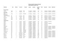
Area Summary L12-14 - Department of Mines and Petroleum
Area Summary L12-14 - Department of Mines and Petroleum
Area Summary L12-14 - Department of Mines and Petroleum

Create successful ePaper yourself
Turn your PDF publications into a flip-book with our unique Google optimized e-Paper software.
Topography<br />
Release <strong>Area</strong> <strong>L12</strong>-<strong>14</strong> extends eastward over a coastal<br />
system <strong>of</strong> dunes, limestone ridges, <strong>and</strong> wetl<strong>and</strong>s, <strong>and</strong><br />
spans the relatively featureless Swan Coastal Plain, which<br />
is bounded by the Whicher Range in the eastern <strong>and</strong><br />
southeastern parts <strong>of</strong> the area. The range contains eroded<br />
Lower Cretaceous rocks, rising to a maximum elevation <strong>of</strong><br />
160 m, <strong>and</strong> is bounded by the Whicher Scarp. The scarp is<br />
a curved erosional feature extending parallel to the coast<br />
about 15 km inl<strong>and</strong>. The more prominent Darling Scarp<br />
is located farther east <strong>and</strong> joins the Whicher Range to the<br />
northeast <strong>of</strong> the area (Freeman <strong>and</strong> Donaldson, 2006). The<br />
Whicher Range is a part <strong>of</strong> the Blackwood Plateau, covered<br />
with native eucalypt forest. The Darling Scarp is associated<br />
with the position <strong>of</strong> the Darling Fault, which defines the<br />
eastern boundary <strong>of</strong> the Perth Basin (Figs 1 <strong>and</strong> 2).<br />
Wells <strong>and</strong> seismic coverage<br />
Twelve deep (>1000 m) stratigraphic <strong>and</strong> exploration<br />
wells have been drilled within the Bunbury Trough, all to<br />
the south <strong>of</strong> the Release <strong>Area</strong> (Table 1). Fair to good gas<br />
shows were encountered within the Willespie Formation<br />
in most wells, including Sabina River 1. The latter<br />
was drilled 7 km southwest <strong>of</strong> Wonnerup 1 to test the<br />
hydrocarbon potential <strong>of</strong> Permian s<strong>and</strong>stones within the<br />
Sue Group, though the well may not have tested a valid<br />
trap (Crostella <strong>and</strong> Backhouse, 2000).<br />
Some stratigraphic data are available from hydrogeological<br />
bores within the Release <strong>Area</strong> (Fig. 3; Comm<strong>and</strong>er, 1982).<br />
Four <strong>of</strong> these are between 1000 m <strong>and</strong> 1200 m deep. Five<br />
others are located close to the southern border <strong>of</strong> the area,<br />
four <strong>of</strong> which are over 1000 m deep (Wharton, 1981).<br />
Several <strong>of</strong> the bores appear to have terminated within the<br />
Cattamarra Coal Measures, although only two (Q2 <strong>and</strong><br />
Q3) intersected the Sue Group. They are located to the<br />
west <strong>of</strong> the Wirring Fault in the Vasse Shelf, between 10<br />
<strong>and</strong> 15 km west <strong>of</strong> Busselton (Wharton, 1981).<br />
Seismic coverage is sparse, except for the southwestern<br />
part <strong>of</strong> the Release <strong>Area</strong> (Fig. 3). Line H69-7 (Harvey<br />
SS, 1969) extends into the Release <strong>Area</strong> from the north<br />
<strong>and</strong> terminates at its southern border. Line A61-049<br />
(Ambergate SS, 1980–81) also extends from southwest<br />
into the area. Three lines <strong>of</strong> the Margaret River seismic<br />
survey (1968) lie entirely within the area. From north to<br />
south, these are MR68-AM, MR68-AL, <strong>and</strong> MR68-AN.<br />
The quality <strong>of</strong> vintage data can be an issue for effective<br />
exploration (Luck, 1990; WA:ERA, 2012), although<br />
reprocessing may significantly improve the data quality.<br />
Regional geology <strong>and</strong><br />
prospectivity<br />
The Bunbury Trough is an asymmetrical full-graben,<br />
nearly 150 km long <strong>and</strong> up to 50 km wide, extending<br />
<strong>of</strong>fshore (Fig. 2). It is tilted toward the east across a series<br />
<strong>of</strong> longitudinal normal faults between its bounding faults,<br />
Geology <strong>and</strong> petroleum prospectivity <strong>of</strong> State Acreage Release <strong>Area</strong> <strong>L12</strong>-<strong>14</strong>, Southern Perth Basin<br />
5<br />
the Darling <strong>and</strong> the Busselton Faults (Iasky, 1993, fig. 10).<br />
The Darling Fault has an estimated cumulative throw <strong>of</strong><br />
up to about 11 km in the eastern part <strong>of</strong> the Release <strong>Area</strong><br />
(Iasky, 1993). It has had a longer history <strong>of</strong> reactivation<br />
than the Busselton Fault, probably going back to early<br />
Proterozoic (Wilde <strong>and</strong> Nelson, 2001). The Darling Fault<br />
has also exerted fundamental control on the development<br />
<strong>of</strong> the Perth Basin <strong>and</strong> its pattern <strong>of</strong> subsidence (Dentith<br />
et al., 1994). By comparison, the Busselton Fault is a<br />
Middle–Late Mesozoic normal fault.<br />
The structural configuration <strong>of</strong> the Perth Basin is a<br />
product <strong>of</strong> a multi-phase process <strong>of</strong> oblique rifting, which<br />
commenced in the Early Permian <strong>and</strong> terminated with the<br />
breakup <strong>of</strong> Australia from Greater India during the Early<br />
Cretaceous (Harris, 1994). In the southern Perth Basin,<br />
two phases <strong>of</strong> transtension <strong>and</strong> transpression followed by<br />
another phase <strong>of</strong> extension have been recognized between<br />
the Dunsborough <strong>and</strong> the Darling Faults (Iasky et al.,<br />
1991; Iasky, 1993, fig. <strong>14</strong>). In the first phase, right-lateral<br />
movement along the Darling Fault along with northeast–<br />
southwest compression resulted in north-northwest<br />
trending folds during the Late Permian to the Early<br />
Triassic. In the second phase, left-lateral movement along<br />
the Dunsborough Fault took place along with northwest–<br />
southeast compression during the Jurassic. Finally, normal<br />
faulting along the Darling <strong>and</strong> the Dunsborough Faults<br />
<strong>and</strong> right-lateral movement along the Harvey Ridge led<br />
to continental breakup during the Early Cretaceous.<br />
Therefore, wrench-induced en echelon folds — such as<br />
those drilled in the Whicher Range Gasfield <strong>and</strong> Wonnerup<br />
1 (Crostella <strong>and</strong> Backhouse, 2000) — may have been<br />
dissected by the dominantly extensional phase <strong>of</strong> faulting<br />
during the Early Cretaceous.<br />
Folding may have been augmented along the Bunbury<br />
Trough by the presence <strong>of</strong> two rigid crystalline blocks<br />
to the east <strong>and</strong> west (Iasky, 1993). The Leeuwin Inlier<br />
extends northward <strong>of</strong>fshore <strong>and</strong> joins the Southern Turtle<br />
Dove Ridge, which defines the western boundary <strong>of</strong> the<br />
central Perth Basin (Iasky <strong>and</strong> Lockwood, 2004). Further<br />
faulting <strong>and</strong> fault reactivation during the Early Cretaceous<br />
<strong>and</strong> the absence <strong>of</strong> regional or effective marine seals can<br />
have serious implications for seal integrity in the s<strong>and</strong>rich<br />
<strong>and</strong> faulted Upper Permian to Lower Cretaceous<br />
succession <strong>of</strong> the Bunbury Trough. However, not all <strong>of</strong> the<br />
folds have been dissected <strong>and</strong> other types <strong>of</strong> traps are also<br />
possible (Crostella <strong>and</strong> Backhouse, 2000).<br />
The northern <strong>and</strong> southern parts <strong>of</strong> the basin have<br />
similar stratigraphic histories (Fig. 4). For example, both<br />
parts contain thick intervals <strong>of</strong> coal measures within<br />
the Permian <strong>and</strong> Jurassic sections. However, viable<br />
objectives younger than Permian may be less likely in<br />
the Bunbury Trough (Crostella <strong>and</strong> Backhouse, 2000),<br />
as thermal maturity modelling suggests that only the<br />
Permian–Triassic section is within the oil window<br />
(Iasky, 1993). This is probably because <strong>of</strong> a lower rate<br />
<strong>of</strong> heat flow, which might be due the thick <strong>and</strong> relatively<br />
‘cool’ continental crust <strong>of</strong> the trough (Iasky, 1993). The<br />
D<strong>and</strong>aragan Trough, which is the main depocentre <strong>and</strong><br />
kitchen <strong>of</strong> the northern part <strong>of</strong> the basin with a comparable<br />
sedimentary fill to that <strong>of</strong> Bunbury Trough, has an<br />
average geothermal gradient <strong>of</strong> 2.5°C/100 m (Crostella,