Moneydarragh More - Queen's University Belfast
Moneydarragh More - Queen's University Belfast
Moneydarragh More - Queen's University Belfast

Create successful ePaper yourself
Turn your PDF publications into a flip-book with our unique Google optimized e-Paper software.
<strong>Moneydarragh</strong> <strong>More</strong>, Annalong, Co. Down<br />
Evaluation/Monitoring Report No. 076<br />
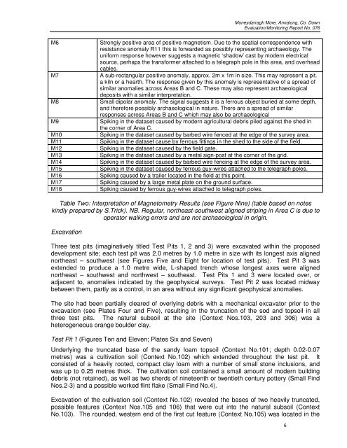
M6 Strongly positive area of positive magnetism. Due to the spatial correspondence with<br />
resistance anomaly R11 this is forwarded as possibly representing archaeology. The<br />
uniform response however suggests a magnetic ‘shadow’ cast by modern electrical<br />
source, perhaps the transformer attached to a telegraph pole in this area, and overhead<br />
cables.<br />
M7 A sub-rectangular positive anomaly, approx. 2m x 1m in size. This may represent a pit.<br />
a kiln or a hearth. The response given by this anomaly is representative of a spread of<br />
similar anomalies across Areas B and C. These may also represent archaeological<br />
deposits with a similar interpretation.<br />
M8 Small dipolar anomaly. The signal suggests it is a ferrous object buried at some depth,<br />
and therefore possibly archaeological in nature. There are a spread of similar<br />
responses across Areas B and C which may also be archaeological<br />
M9 Spiking in the dataset caused by modern agricultural debris piled against the shed in<br />
the corner of Area C.<br />
M10 Spiking in the dataset caused by barbed wire fenced at the edge of the survey area.<br />
M11 Spiking in the dataset cause by ferrous fittings in the shed to the side of the field.<br />
M12 Spiking in the dataset caused by the field gate.<br />
M13 Spiking in the dataset caused by a metal sign-post at the corner of the grid.<br />
M14 Spiking in the dataset caused by barbed wire fencing at the edge of the survey area.<br />
M15 Spiking in the dataset caused by ferrous guy-wires attached to the telegraph poles.<br />
M16 Spiking caused by a trailer located in the field at this point.<br />
M17 Spiking caused by a large metal plate on the ground surface.<br />
M18 Spiking caused by ferrous guy-wires attached to telegraph poles.<br />
Table Two: Interpretation of Magnetometry Results (see Figure Nine) (table based on notes<br />
kindly prepared by S.Trick). NB. Regular, northeast-southwest aligned striping in Area C is due to<br />
operator walking errors and are not archaeological in origin.<br />
Excavation<br />
Three test pits (imaginatively titled Test Pits 1, 2 and 3) were excavated within the proposed<br />
development site; each test pit was 2.0 metres by 1.0 metre in size with its longest axis aligned<br />
northeast – southwest (see Figures Five and Eight for location of test pits). Test Pit 3 was<br />
extended to produce a 1.0 metre wide, L-shaped trench whose longest axes were aligned<br />
northeast – southwest and northwest – southeast. Test Pits 1 and 3 were located over, or<br />
adjacent to, anomalies indicated by the geophysical surveys. Test Pit 2 was located midway<br />
between them, partly as a control, in an area without any significant geophysical anomalies.<br />
The site had been partially cleared of overlying debris with a mechanical excavator prior to the<br />
excavation (see Plates Four and Five), resulting in the truncation of the sod and topsoil in all<br />
three test pits. The natural subsoil at the site (Context Nos.103, 203 and 306) was a<br />
heterogeneous orange boulder clay.<br />
Test Pit 1 (Figures Ten and Eleven; Plates Six and Seven)<br />
Underlying the truncated base of the sandy loam topsoil (Context No.101; depth 0.02-0.07<br />
metres) was a cultivation soil (Context No.102) which extended throughout the test pit. It<br />
consisted of a heavily rooted, compact clay loam with a number of small stone inclusions, and<br />
was up to 0.25 metres thick. The cultivation soil contained a small amount of modern building<br />
debris (not retained), as well as two sherds of nineteenth or twentieth century pottery (Small Find<br />
Nos.2-3) and a possible worked flint flake (Small Find No.4).<br />
Excavation of the cultivation soil (Context No.102) revealed the bases of two heavily truncated,<br />
possible features (Context Nos.105 and 106) that were cut into the natural subsoil (Context<br />
No.103). The rounded, western end of the first cut feature (Context No.105) was located in the<br />
6