Mansion_rev8.qxd - National Park Service
Mansion_rev8.qxd - National Park Service
Mansion_rev8.qxd - National Park Service

Create successful ePaper yourself
Turn your PDF publications into a flip-book with our unique Google optimized e-Paper software.
the entire homeland, were often spiritually revered. In<br />
the nineteenth century, historians recorded Abenaki<br />
petroglyphs of the native flora and fauna that reflected the<br />
culture’s value of the natural world. [Figure 1.5]<br />
The Western Abenaki called their homeland Ndakinna<br />
meaning “our land.” 13 The land was organized into territories<br />
belonging to five bands—the Missisquois, Pigwackets,<br />
Pennacooks, Sokokis, and Cowasucks—whose individual<br />
homelands occupied distinct geographic regions, each<br />
with a principal year-round village. [Figure 1.6] At the time<br />
of European contact in the seventeenth century, the<br />
Woodstock area was probably within the Cowasuck<br />
homeland. The principal Cowasuck village was Cowass,<br />
located near the present-day village of Newbury, Vermont,<br />
on the Connecticut River. 14<br />
During the warmer seasons, families left the principal<br />
village for their own hunting territories, established<br />
according to the limits of watersheds, where they maintained<br />
small seasonal camps. 15 Little is known about the<br />
appearance of these seasonal camps, except that they were<br />
usually established on high ground close to rivers, and had<br />
agricultural fields on adjoining floodplains. 16 In these<br />
fields, the Western Abenaki may have grown crops such as<br />
corn, beans, squash, and tobacco. Agriculture was limited<br />
by the short growing season, so that hunting, fishing, and<br />
gathering remained important mainstays. Passenger<br />
pigeons, deer, bears, moose, muskrat, beaver, and otter,<br />
along with eel, salmon, and trout were important staples.<br />
Some of the Western Abenakis’ favorite foods gathered<br />
from the forests included maple and birch sap, spring<br />
greens, blueberries, butternuts, and chestnuts. 17<br />
The first Europeans to settle at the eastern foot of Mount<br />
Tom in the 1770s encountered what was probably evidence<br />
of Native American habitation. Historian Henry Swan<br />
Dana, in his 1889 History of Woodstock, wrote that settlers<br />
found a clearing in the woods on the floodplain east of the<br />
<strong>Mansion</strong> grounds near the present location of the barns at<br />
Billings Farm & Museum. According to Dana, this clearing<br />
had been “occupied some time in the history of this valley<br />
as an Indian camping ground.” The exact location and size<br />
of the clearing was not recorded, and apparently the<br />
PRE-1789<br />
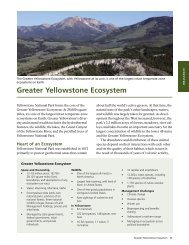
Figure 1.6: Ndakinna, the Western Abenaki homeland, showing general<br />
location of major bands about 1600. Based on map in Colin<br />
Calloway, The Western Abenakis of Vermont (Norman: University of<br />
Oklahoma Press, 1990), 4-5. SUNY ESF.<br />
Europeans found no other traces of habitation, as by that<br />
time the camp may have been long abandoned. 18 The<br />
Western Abenaki population had been decimated by this<br />
time due to many factors, including European diseases and<br />
cultural influences. Already by the mid seventeenth century,<br />
the population had fallen from a pre-contact level of<br />
about 10,000 to a few hundred, a decline of more than<br />
ninety percent by best estimates. 19<br />
Given that the Western Abenaki had practiced agriculture<br />
for centuries prior to the arrival of the Europeans, the<br />
clearing observed by European settlers may have been a<br />
fallow agricultural field that was part of a Cowasuck family’s<br />
seasonal camp. This location would have provided<br />
such desirable attributes as ready access to water, including<br />
the Ottauquechee River, its tributary Barnard Brook (then<br />
known as the North Branch of the Ottauquechee River),<br />
and springs on Mount Tom; elevated terraces to provide<br />
safety from floods; and southern and eastern exposure for<br />
13