55061_12_Ch12_p320_347 pp2.indd - Cengage Learning
55061_12_Ch12_p320_347 pp2.indd - Cengage Learning
55061_12_Ch12_p320_347 pp2.indd - Cengage Learning

You also want an ePaper? Increase the reach of your titles
YUMPU automatically turns print PDFs into web optimized ePapers that Google loves.
Soils and Soil Development<br />
Soil is an outstanding example of the interrelationships among<br />
Earth’s subsystems.<br />
■ Why is soil such a good example of the interaction and integration<br />
of subsystems?<br />
■ Why should soil be considered an open system?<br />
Soil water is the means by which plants receive dissolved nutrients<br />
that are essential for growth.<br />
■ Why is gravitational water such an effective agent of solution?<br />
■ How is capillary water important during periods of drought?<br />
Soil fertility depends on many factors, and a soil that is fertile for<br />
one vegetation type may not be for another.<br />
■ What factors determine a soil’s fertility, and how is vegetation<br />
involved?<br />
■ How are acidity and alkalinity related to soil fertility?<br />
On a global scale, climate exerts a major infl uence on the<br />
formation and characteristics of soils.<br />
■<br />
■<br />
CHAPTER PREVIEW<br />
How do temperature, precipitation, and moisture regimes affect<br />
the development of soils?<br />
Why is the regional distribution of soils similar to regions of<br />
climate and vegetation?<br />
Soils are among the world’s most critical and widely abused yet<br />
least understood natural resources.<br />
■ How are soils abused or neglected as a resource?<br />
■ What can be done to conserve soils?<br />
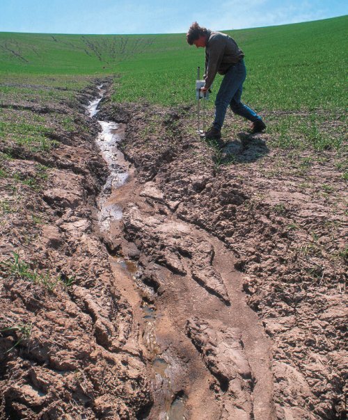
Opposite: Scientists work to understand and control erosional losses<br />
and other problems that threaten our precious natural resource—soil.<br />
USDA/ARS/Photo by Jack Dykinga<br />
▼<br />
<strong>12</strong><br />
W hat are the four most important natural<br />
constituents that permit life as we know it to exist<br />
on Earth? Many people if asked that question would reply,<br />
“air, water, and sunlight,” right away, but they might have<br />
to think harder and longer about their fourth answer. Most<br />
people give little attention to that fourth natural resource,<br />
but it is essential for their life on Earth, and it lies right below<br />
their feet. Soil is that critical resource. The soil mantle that<br />
covers most land surfaces is indispensable, but fragile, and<br />
threatened by erosion, pollution, or being covered over by<br />
the human-built environment. Soil provides nutrients that<br />
directly or indirectly support much of life on Earth.<br />
Soil is a dynamic natural body capable of supporting<br />
a vegetative cover. It contains chemical solutions, gases,<br />
organic refuse, flora, and fauna. The physical, chemical, and<br />
biological processes that take place among the components<br />
of a soil are integral parts of its dynamic character. Soil<br />
responds to climatic conditions (especially temperature and<br />
moisture), to the land surface configuration, to vegetative<br />
cover and composition, and to animal activity.<br />
Soil has been called “the skin of the Earth.” The<br />
condition and nature of a soil reflects both the ancient<br />
environments under which it formed, and today’s<br />
environmental conditions. A soil functions as an<br />
environmental system, adapting, reflecting, and responding<br />
321
322<br />
CHAPTER <strong>12</strong> SOILS AND SOIL DEVELOPMENT<br />
to a great variety of natural and human-influenced processes. Soil<br />
is an exceptional example of the integration, interdependence, and<br />
overlap among Earth’s subsystems because the characteristics of a<br />
soil reflect the atmospheric, hydrologic, lithologic, and biotic conditions<br />
under which it developed ( ● Fig. <strong>12</strong>.1). In fact, because<br />
soils integrate these major subsystems so well, they are sometimes<br />
considered a separate system called the pedosphere (from Greek:<br />
pedon, ground).<br />
Soil is also home to numerous living organisms, forming<br />
the environments in which they live, both above and below the<br />
ground surface. The life-forms that live in or on a soil play significant<br />
roles in the development and characteristics of a soil,<br />
and through human population growth and expanding civilizations,<br />
potentially negative impacts on soils have increased<br />
dramatically.<br />
How a soil develops and its resulting characteristics depend<br />
on a great number of factors. But when soils are viewed on a<br />
world regional scale, a strong and significant influence is climate.<br />
The relationships between soils, climate types, and their associated<br />
environments were considered in Chapters 9 and 10.<br />
Major Soil Components<br />
What is soil actually made of ? What does a shovel contain when it<br />
scoops up a load of soil? What soil characteristics support and influence<br />
variations in Earth’s vegetational environments? Soils contain<br />
four major components, and there are many processes that act<br />
on these components. The four major components of soil are inorganic<br />
materials, soil water, soil air, and organic matter ( ● Fig. <strong>12</strong>.2).<br />
Inorganic Materials<br />
Soils contain varying amounts of insoluble materials—rock fragments<br />
and minerals that will not readily dissolve in water. Soils<br />
also contain soluble minerals, which supply dissolved chemicals<br />
held in solution. Most minerals found in soils are combinations<br />
● FIGURE <strong>12</strong>.1<br />
The intertwined links between soil and the major Earth subsystems.<br />
Why is soil considered to be such an integrator of Earth systems?<br />
Biosphere<br />
Atmosphere<br />
SOIL<br />
Lithosphere<br />
Hydrosphere<br />
From Purves, et al., Life: The Science of Biology, Fourth Edition. Used with<br />
permission of Sinauer Associates, Inc.<br />
USDA/NRCS/Lynn Betts<br />
of the common elements of Earth’s surface rocks: silicon, aluminum,<br />
oxygen, and iron. Some of these constituents occur as solid<br />
chemical compounds, and others are found in the air and water<br />
that are also vital components of a soil. Soils sustain Earth’s land<br />
● FIGURE <strong>12</strong>.2<br />
The four major components of soil. Soil contains a complex assemblage<br />
of inorganic minerals and rocks, along with water, air, and organic matter.<br />
The interaction among these components and the proportion of each<br />
are important factors in the development of a soil.<br />
How do each of these soil components contribute to making a soil<br />
suitable to support plant life?<br />
Microcolonies<br />
of bacteria<br />
Quartz<br />
H 2O<br />
Quartz<br />
Air<br />
Organic<br />
matter<br />
Clay particle<br />
Air<br />
Clay particle<br />
Quartz<br />
● FIGURE <strong>12</strong>.3<br />
Fertilizers increase the productivity of soils. This farmer is adding<br />
nitrogen fertilizer into the soil on this Iowa farm.<br />
Why can soil fertilizer be either useful or detrimental when it is<br />
introduced into the soil system?
ecosystems by providing a great variety of necessary chemical elements<br />
and compounds to life-forms. Carbon, hydrogen, nitrogen,<br />
sodium, potassium, zinc, copper, iodine, and compounds of these<br />
elements are important in soils. The chemical constituents of a<br />
soil typically come from many sources—the breakdown (weathering)<br />
of underlying rocks, deposits of loose sediments, and minerals<br />
dissolved in water. Organic activities help to disintegrate rocks,<br />
create new chemical compounds, and release gases into the soil.<br />
Plants need many chemical substances for growth, and having<br />
a knowledge of a soil’s mineral and chemical content is necessary<br />
for determining its potential productivity. Soil fertilization<br />
is the process of adding nutrients or other constituents in order to<br />
meet the soil conditions that certain plants require ( ● Fig. <strong>12</strong>.3).<br />
Soil Water<br />
The original source of soil water is precipitation. When precipitation<br />
falls on the land, the water that is not evaporated away is either<br />
absorbed into the ground or by vegetation, or it runs downslope.<br />
Soil water is both an ingredient and a catalyst for chemical reactions<br />
that sustain life and influence soil development. Water also<br />
● FIGURE <strong>12</strong>.4<br />
The interrelationships between a soil and the environmental factors that influence soil development. Soil is an<br />
example of an open system because it receives inputs of matter and energy, stores part of these inputs, and<br />
outputs matter and energy. Note the inputs and outputs on this diagram.<br />
What are some examples of energy and matter that flow into and out of the soil system?<br />
Run-in gravitational water<br />
zone of aeration<br />
Capillary<br />
fringe<br />
water<br />
Mineral particle<br />
MAJOR SOIL COMPONENTS<br />
provides nutrients in a form that can be extracted by vegetation. As<br />
water moves through a soil it washes over and through various soil<br />
components, dissolving some of these materials and carrying them<br />
through the soil. Soil water is not pure, but is a solution that contains<br />
soluble nutrients. Plants need air, water, and minerals to function,<br />
live, and grow, and they depend on soil for much of these necessities.<br />
A soil functions as an open system. Matter and energy flow<br />
into and out of a soil, and they are also held in storage ( ● Fig. <strong>12</strong>.4).<br />
Understanding these flows—inputs and outputs, the components<br />
and processes involved, and how they vary from soil to soil—is a<br />
key to appreciating the complexities of this natural resource.<br />
The water in a soil is found in several different circumstances<br />
(see again Fig. <strong>12</strong>.4). Soil water adheres to soil particles and soil<br />
clumps by surface tension (the property that causes small water<br />
droplets to form rounded beads instead of spreading out in a thin<br />
film). This soil water, called capillary water, serves as a stored<br />
water supply for plants. Capillary water can move in all directions<br />
through soil because it migrates from areas with more water to<br />
areas with less. Thus, during dry periods, when there is no gravitational<br />
water flowing through the soil, capillary water can move<br />
upward or horizontally to supply plant roots with moisture and<br />
dissolved nutrients.<br />
Water<br />
Precipitation<br />
Air Hygroscopic<br />
water<br />
Solid bedrock<br />
Weathered bedrock<br />
Groundwater flow<br />
Joints<br />
Organic additions<br />
and soil faunal<br />
activity<br />
Water table<br />
Runoff<br />
(surface water)<br />
Below water table<br />
zone of saturation<br />
323
324<br />
CHAPTER <strong>12</strong> SOILS AND SOIL DEVELOPMENT<br />
Capillary water migrates upward and moves minerals from<br />
the subsoil toward the surface. If this capillary water evaporates<br />
away, the formerly dissolved minerals remain, generally as alkaline<br />
or saline deposits in the topsoil. High concentrations of certain<br />
mineral deposits, like these, can be detrimental to plants and animals<br />
existing in the soil. Lime (calcium carbonate) deposited by<br />
evaporating soil water can build up to produce a cementlike layer,<br />
called caliche, which like a clay hardpan prevents the downward<br />
percolation of water.<br />
Soil water is also found as a very thin film, invisible to the<br />
naked eye, that is bound to the surfaces of soil particles by strong<br />
electrical forces. This is hygroscopic water, which does not<br />
move through the soil, and it also does not supply plants with the<br />
moisture that they need.<br />
Water that percolates down through a soil, under the force of<br />
gravity, is called gravitational water. Gravitational water moves<br />
downward through voids between soil particles and toward the<br />
water table—the level below which all available spaces are filled<br />
with water. The quantity of gravitational water in a soil is related<br />
to several conditions, including the amount of precipitation, the<br />
time since it fell, evaporation rates, the space available for water<br />
storage, and how easily the water can move through the soil.<br />
Gravitational water performs several functions in a soil<br />
( ● Fig. <strong>12</strong>.5). As gravitational water percolates downward, it dissolves<br />
soluble minerals and carries them into deeper levels of<br />
the soil, perhaps to the zone where all open spaces are saturated.<br />
Depleting nutrients in the soil by the through flow of<br />
water is called leaching. In regions of heavy rainfall, leaching<br />
is common and can be intense, robbing a topsoil of all but the<br />
insoluble substances.<br />
Gravitational water moving down through a soil also takes<br />
with it the finer particles (clay and silt) from the upper soil layers.<br />
This downward removal of soil components by water is called<br />
eluviation. As gravitational water percolates downward, it deposits<br />
the fine materials that were removed from the topsoil at<br />
a lower level in the soil. Deposition by water in the subsoil is<br />
called illuviation. Gravitational water also mixes soil particles<br />
as it moves them downward. One result of eluviation is that the<br />
texture of a topsoil tends to become coarser as the fine particles<br />
are removed. Consequently, the topsoil’s ability to retain water is<br />
reduced. Illuviation may eventually cause the subsoil to become<br />
dense and compact, forming a clay hardpan.<br />
Leaching and eluviation both strongly influence the characteristic<br />
layered changes with depth, or stratification. Fine particles<br />
and substances dissolved from the upper soil are deposited<br />
in lower levels, which become dense and may be strongly colored<br />
by accumulated iron compounds.<br />
Soil Air<br />
● FIGURE <strong>12</strong>.5<br />
Water plays several important roles in the processes that affect soil development. Water is important in<br />
moving nutrients and particles vertically, both up and down, in a soil.<br />
How does deposition by capillary water differ from deposition (illuviation) by gravitational water?<br />
Plant litter<br />
Faunal activity downward<br />
mixing organic material<br />
Leaching<br />
of solubles<br />
Redeposition<br />
of some<br />
solubles<br />
Loss of some<br />
solubles in<br />
groundwater outflow<br />
Precipitation<br />
Much of a soil—in some cases, approaching 50%—consists of<br />
spaces between soil particles and between clumps (aggregates of<br />
soil particles). Voids that are not filled with water contain air or<br />
certain gases. Compared to the composition of the lower atmosphere,<br />
the air in a soil is likely to have less oxygen, more carbon<br />
dioxide, and a fairly high relative<br />
humidity because of the presence of<br />
Organic additions (plant litter)<br />
Organic additions (underground)<br />
Eluviation of fine<br />
particles (depletion)<br />
Illuviation of fine<br />
particles (additions)<br />
Capillary rise and evaporation<br />
deposits chemical load<br />
Water table<br />
capillary and hygroscopic water.<br />
For most microorganisms and<br />
plants that live in the ground, soil<br />
air supplies oxygen and carbon<br />
dioxide necessary for life processes.<br />
The problem with a watersaturated<br />
soil is not necessarily excess<br />
water but, if all pore spaces are<br />
filled with water, there is no air<br />
supply. The lack of air is why many<br />
plants find it difficult to survive in<br />
water-saturated soils.<br />
Organic Matter<br />
Soil contains organic matter in addition<br />
to minerals, gases, and water.<br />
The decayed remains of plant and<br />
animal materials, partially transformed<br />
by bacterial action, are collectively<br />
called humus. Humus is<br />
an important catalyst in chemical<br />
reactions that help plants to extract<br />
soil nutrients. Humus also supplies<br />
nutrients and minerals to the soil.<br />
Soils that contain humus are quite
workable and have a good capacity to retain water. Humus also<br />
provides an abundant food source for microscopic soil organisms.<br />
Most soils are actually environments that teem with life, ranging<br />
from microscopic bacteria and fungi, to earthworms, rodents,<br />
and other burrowers. Animals contribute to the soil development<br />
and enrichment by creating humus from plant litter. They also mix<br />
organic material deeper into the soil, and move inorganic fragments<br />
toward the surface. In addition, the functions of plants and<br />
their root systems are integral parts of the soil-forming system.<br />
Soils vary at local, regional, and global scales. Particularly strong<br />
relationships exist between a soil and the vegetation and climate at<br />
its location. For example, soils in middle-latitude grasslands normally<br />
have a very high proportion of organic matter; those in deserts<br />
are thin, and rich in minerals left behind by evaporating water,<br />
like lime and salts; and tropical soils typically have a high content of<br />
iron and aluminum oxides. Knowing a soil’s water, mineral, and organic<br />
components and their proportions can help us determine its<br />
productivity and what the best use for that particular soil might be.<br />
Characteristics of Soil<br />
Several soil properties that can be readily tested or examined are<br />
used to describe and differentiate soil types. The most important<br />
properties include color, texture, structure, acidity or alkalinity,<br />
and capacity to hold and transmit water and air.<br />
Color<br />
Color is the most visible soil characteristic, but it might not be the<br />
most important attribute. Most people are aware of how soils vary<br />
in color from place to place. For example, the well-known red clay<br />
soils of Georgia are not far from Alabama’s belt of black soils. Soils<br />
vary in color from black to brown to red, yellow, gray, and nearwhite.<br />
A soil’s color is generally related to its physical and chemical<br />
characteristics. When describing soils in the field or samples in<br />
the laboratory, soil scientists use a book of standardized colors to<br />
clearly and precisely identify this coloration ( ● Fig. <strong>12</strong>.6).<br />
Decomposed organic matter is black or brown, so soils with<br />
high humus contents tend to be dark. If the humus content<br />
of soil decreases because of either low organic activity or loss<br />
of organics through leaching, soil colors typically fade to light<br />
brown or gray. Soils rich in humus are usually very fertile. For<br />
this reason, dark brown or black soils are often referred to as<br />
rich. However, this is not always true because some black or dark<br />
brown soils have little or no humus, but are dark because of<br />
other soil-forming factors.<br />
Soils that are red or yellow typically indicate the presence of<br />
iron. In moist climates, a light gray or white soil indicates that iron<br />
has been leached out, leaving oxides of silicon and aluminum; in<br />
dry climates, the same color typically indicates a high proportion<br />
of calcium or salts.<br />
Soil colors provide useful clues to the physical and chemical<br />
characteristics of soils and make the job of recognizing different<br />
soil types easier. But color alone does not answer all the important<br />
questions about a soil’s qualities or fertility.<br />
Courtesy of James P. Shoryer, Kansas State University Research and Extension<br />
Texture<br />
CHARACTERISTICS OF SOIL<br />
● FIGURE <strong>12</strong>.6<br />
Determining soil color. A standardized classification system is used to<br />
determine precise color by comparing the soil to the color samples<br />
found in Munsell soil color books.<br />
In general, how would you describe the color of the soils where<br />
you live?<br />
Soil texture refers to the particle sizes (or distribution of sizes)<br />
that make up a soil ( ● Fig. <strong>12</strong>.7). In clayey soils, the dominant<br />
size is clay particles, defined as having diameters of less than<br />
0.002 millimeter (soil scientists universally use the metric system).<br />
In silty soils, the dominant silt particles are defined as being between<br />
0.002 and 0.05 millimeter. Sandy soils have mostly sandsized<br />
particles, with diameters between 0.05 and 2.0 millimeters.<br />
Rocks larger than 2.0 millimeters are regarded as pebbles, gravel,<br />
or rock fragments, and technically are not soil particles.<br />
The proportion of particle sizes determines a soil’s texture.<br />
For example, a soil composed of 50% silt-sized particles, 45% clay,<br />
and 5% sand would be identified as a silty clay. A triangular graph<br />
( ● Fig. <strong>12</strong>.8) is used to discern different classes of soil texture<br />
based on the plot of percentages for each soil grade (as sand,<br />
silt, and clay are called) within each class. Point A within the silty<br />
clay class represents the example just given. A second soil sample<br />
(B) that is 20% silt, 30% clay, and 50% sand would be referred to<br />
as a sandy clay loam. Loam soils, which occupy the central areas<br />
of the triangular graph, are soils with a mix of the three grades<br />
(sizes) of soil particles without any size being greatly dominant. It<br />
is interesting to note that loam soils are generally best suited for<br />
supporting vegetation growth.<br />
Soil texture helps determine a soil’s capacity to retain moisture<br />
and air that are necessary for plant growth. Soils with a higher<br />
proportion of larger particles tend to be well aerated and allow<br />
water to infiltrate (seep through) the soil quickly—sometimes<br />
so quickly that plants are unable to use the water. Clay soils present<br />
the opposite problem because they retard water movement,<br />
becoming waterlogged and deficient in air. Aeration of the soil is<br />
an important process in cultivation, and plowing a soil opens its<br />
structure and increases its air content.<br />
325
326<br />
CHAPTER <strong>12</strong> SOILS AND SOIL DEVELOPMENT<br />
GEOGRAPHY’S PHYSICAL SCIENCE PERSPECTIVE<br />
Basic Soil Analysis<br />
After studying just one chapter on<br />
soils, no one would expect any<br />
introductory student to be able to<br />
do a detailed soil analysis. However, there<br />
are some basic observations that anyone<br />
can perform to better understand a few<br />
properties of a local soil. No equipment is<br />
required to make analyses; only visual and<br />
hands-on examinations are necessary.<br />
Soil Color<br />
Soil color can hold clues to the composition<br />
and/or the formation processes of that soil.<br />
Figure <strong>12</strong>.6 shows the Munsell color book,<br />
a standard guide for matching and recognizing<br />
precise colors of soil types. The book includes<br />
common soil colors, but each color<br />
can also appear in a wide variety of tones.<br />
Red: Reddish soil usually indicates that<br />
oxidation has been an active process—<br />
oxygen has chemically reacted with the<br />
soil minerals. Red also indicates that iron<br />
is in the soil. Just like rusting iron, many<br />
iron-rich minerals turn red when oxidized.<br />
The formula for this process is FeO + O 2 →<br />
Fe 2 O 3 (ferrous oxide + oxygen becomes<br />
hematite, a reddish iron oxide).<br />
© Jeff Vanuga/USDA Natural Resources Conservation Service<br />
Blue/Silver/Gray: These tones mean<br />
that the soil has likely been reduced; in<br />
other words, oxygen has been removed<br />
from the soil.<br />
Fe 2 O 3 → FeO + O 2 (the previous<br />
formula in reverse)<br />
White: Usually denotes that calcium<br />
carbonate (CaCO 3 ) or salts (such as NaCl)<br />
may be present in the soil.<br />
Black: A very dark color may indicate a<br />
high amount of organic material present<br />
in the soil.<br />
More sophisticated field or laboratory<br />
analyses are required for absolute identification,<br />
but these examples will allow good<br />
working hypotheses for soil characteristics<br />
represented by colors.<br />
Soil Texture<br />
The particle sizes in a soil determine its<br />
texture. Soil texture is a property that you<br />
can feel, and your fingers can help in the<br />
analysis. Sand-sized particles can be easily<br />
recognized because they feel gritty to the<br />
touch. Wetting the soil and working it with<br />
your hands can help in this process. If the<br />
sample is not gritty but rather is smooth<br />
Soil analysis in the field is a hands-on process.<br />
to the touch, then the soil contains silt or<br />
clay. If the sample feels sticky and you can<br />
squeeze a small soil sample into a ribbon<br />
(like with modeling clay), then clay-sized<br />
particles are abundant. Actual percentages<br />
of particle sizes in a soil sample are best<br />
established in a laboratory.<br />
Soil Structure<br />
The shape of clumps that a soil makes<br />
when it is broken apart is called structure<br />
and can be examined by breaking up a<br />
handful of soil. The peds (or small clumps<br />
of soil) may take on some distinctive<br />
shapes. Though the peds may form a<br />
variety of shapes, some of the more common<br />
are granular (denoting a presence<br />
of sand) and platy (showing a presence<br />
of clay). Other soil structures, such as<br />
blocky, columnar, or prismatic, are shown<br />
in Figure <strong>12</strong>.9.<br />
Although these simple procedures will<br />
not yield a complete analysis of a soil sample,<br />
they can certainly be the first steps in<br />
the process. It is interesting to note that pedologists<br />
(soil scientists) while in the field<br />
perform many of these same procedures.
0 1 2<br />
0<br />
Sand<br />
Silt<br />
Clay<br />
Invisible at<br />
this scale<br />
Structure<br />
Comparative sizes of<br />
soil/rock particles<br />
0.05 – 2.0 mm<br />
0.002 – 0.05 mm<br />
1/16<br />
Greatly<br />
enlarged<br />
mm<br />
Inches<br />
Actual size of sand grain 1 mm diameter<br />
● FIGURE <strong>12</strong>.7<br />
Particle sizes in soil. Sand, silt, and clay are terms<br />
that refer to the size of these particles for scientific<br />
and engineering purposes. Here, the sizes of each<br />
can be compared. Clay particles are tiny, sheetlike<br />
particles that cannot be seen.<br />
In most soils, particles clump into distinctive<br />
masses known as soil peds, which give a soil<br />
a distinctive structure. Soil structure influences<br />
a soil’s porosity—the amount of space that<br />
may contain fluids. Soil structure also influences<br />
permeability—the rate at which fluids<br />
such as water can pass through. Permeability<br />
is usually greatest in sandy soils, and porosity<br />
is usually greatest in clayey soils. Both of<br />
these factors control soil drainage as well as<br />
the available moisture in a soil. Soils with similar<br />
textures may have different structures, and<br />
vice versa.<br />
Soil structure can be influenced by outside<br />
factors such as moisture regime and the<br />
nutrient cycles that plants use to interchange<br />
chemicals with the soil, keeping certain ones<br />
in the system while others are leached away.<br />
We have all seen the structural change in<br />
soils that occurs when soils are wet compared<br />
to when they are dry. Human activities also<br />
influence soil structure through cultivation,<br />
irrigation, and fertilization. Fertilizers, as well<br />
as lime or decayed organic debris, encourage<br />
clumping of soil particles and the maintenance<br />
of clumps. Excess sodium and magnesium have the opposite effect,<br />
causing clay soils to become a sticky muck when wet and<br />
like concrete when dry. The absence of smaller particles typically<br />
hinders the development of a well-defined soil structure.<br />
Scientists classify soil structures according to their form. These<br />
range from columns, prisms, and angular blocks, to nutlike spheroids,<br />
laminated plates, crumbs, and granules ( ● Fig. <strong>12</strong>.9). Soils with massive<br />
and fine structures tend to be less useful than aggregates of intermediate<br />
size and stability, which permit good drainage and aeration.<br />
Acidity and Alkalinity<br />
CHARACTERISTICS OF SOIL<br />
An important aspect of soil chemistry is a soil’s departure from<br />
neutrality toward either acidity or alkalinity (baseness). Levels of<br />
acidity or alkalinity are measured on the pH scale of 0 to 14. A<br />
pH reading indicates the concentration of reactive hydrogen ions<br />
present. The pH scale is logarithmic, meaning that each change in a<br />
whole pH number represents a tenfold change. It is also an inverted<br />
scale—a lower pH means a greater amount of hydrogen ions present<br />
(higher acidity). Low pH values indicate an acid soil, and high<br />
pH indicates alkaline conditions ( ● Fig. <strong>12</strong>.10).<br />
● FIGURE <strong>12</strong>.8<br />
The texture of a soil can be represented by a plotting a point on this diagram. Texture is<br />
determined by sieving the soil to determine the percentage of particles falling into the size<br />
ranges for clay, silt, and sand. Note that each of the three axes of the triangle is in a different<br />
color and the line colors also correspond (clay-red, silt-blue, sand-green).<br />
What would a soil that contains 40% sand, 40% silt, and 20% clay be classified as?<br />
0<br />
100<br />
10<br />
20<br />
Sand<br />
90<br />
30<br />
Loamy<br />
sand<br />
40<br />
Percent clay<br />
80<br />
50<br />
60<br />
Sandy<br />
clay<br />
70<br />
70<br />
B<br />
Sandy clay loam<br />
80<br />
60<br />
90<br />
100<br />
0<br />
Clay<br />
50<br />
10<br />
Clay loam<br />
Loam<br />
Percent sand<br />
20<br />
40<br />
30<br />
40<br />
Silty<br />
clay<br />
30<br />
50<br />
Silty clay<br />
loam<br />
Sandy loam Silty loam<br />
A<br />
Percent silt<br />
60<br />
20<br />
70<br />
Silt<br />
80<br />
10<br />
90<br />
100<br />
0<br />
327
328<br />
CHAPTER <strong>12</strong> SOILS AND SOIL DEVELOPMENT<br />
Soil acidity or alkalinity helps determine the available nutrients<br />
that affect plant growth. Plants absorb nutrients that are dissolved<br />
in liquid. However, soil water that lacks some degree of acidity has<br />
little ability to dissolve these nutrients. As a result, even though nutrients<br />
are in the soil, plants may not have access to them.<br />
Most complex plants will grow only in soils with levels<br />
between pH 4 and pH 10, although the optimum pH for vegetation<br />
growth varies with the plant species. Around the world,<br />
vegetation has evolved in and adapted to a variety of climates<br />
and soil environments, both of which can affect soil pH. Certain<br />
species tolerate alkaline soils, and others thrive under more<br />
acid conditions.<br />
Leaching caused by high rainfall gradually replaces soil<br />
elements such as sodium (Na), potassium (K), magnesium (Mg),<br />
and calcium (Ca) with hydrogen. Falling rain picks up atmospheric<br />
carbon dioxide and becomes slightly acidic: H 2 O + CO 2 = H 2 CO 3<br />
(carbonic acid), so desert soils tend to be alkaline and soils in humid<br />
regions tend to be acidic ( ● Fig. <strong>12</strong>.11). The humus content in the<br />
soils of humid areas also contributes to higher soil acidity.<br />
To correct soil alkalinity, common in the arid regions, and<br />
to make the soil more productive, the soil can be flushed with<br />
irrigation water. Strongly acidic soils are also detrimental to plant<br />
growth. In acidic soils, soil moisture dissolves nutrients, but they<br />
may be leached away before plant roots can absorb them. Soil acidity<br />
can generally be corrected by adding lime to the soil. In addition<br />
to affecting plant growth, soil acidity or alkalinity also affects<br />
microorganisms in the soil. Microorganisms are highly sensitive to a<br />
soil’s pH, and each species has an optimum environmental setting.<br />
● FIGURE <strong>12</strong>.9<br />
This guide to classifying the structure of a soil on the basis of soil peds can be used to help<br />
determine other characteristics of a soil.<br />
How does soil structure affect a soil’s usefulness or suitability for agriculture?<br />
Blocky<br />
Platelike<br />
Platy Lenticular<br />
Prismatic<br />
Blocklike<br />
Prismlike<br />
Columnar<br />
Spheroidal<br />
Nuciform Granular Crumb<br />
Development of Soil Horizons<br />
Soil development begins when plants and animals colonize rocks<br />
or deposits of rock fragments, the parent material on which soil<br />
will form. Once organic processes begin among mineral particles<br />
or rock fragments, differences begin to develop from the surface<br />
down through the parent material.<br />
Initially, vertical differences result from the surface accumulation<br />
of organic litter and the removal of fine particles and dissolved<br />
minerals from upper layers by percolating water that<br />
deposits these materials at a lower level. The vertical cross section<br />
of a soil from the surface down to the parent material is<br />
called a soil profile ( ● Fig. <strong>12</strong>.<strong>12</strong>). Examining soil profiles and<br />
the vertical differences they contain is important to recognizing<br />
different soil types and how those soils developed. As climate,<br />
vegetation, animal life, and characteristics of the land surface<br />
affect soil formation over time, this vertical differentiation becomes<br />
more and more apparent.<br />
Soil Horizons<br />
Within their soil profiles, well-developed soils typically exhibit<br />
several distinct layers, called soil horizons, that are distinguished<br />
by their physical and chemical properties. Soils are classified largely<br />
on the differences in their horizons and in the processes responsible<br />
for those differences ( ● Fig. <strong>12</strong>.13). Soil horizons are designated<br />
by a set of letters that refer to their composition, dominant<br />
process, and/or position in the soil profile.<br />
At the surface, but only in locations where<br />
there is a sufficient cover of decomposed vegetation<br />
litter, there will be an O horizon. This<br />
is a layer of organic debris and humus; the<br />
“O” designation refers to this horizon’s high<br />
organic content. Immediately below is the<br />
A horizon, commonly referred to as “topsoil.” In<br />
general, the A horizon is dark because it contains<br />
decomposed organic matter. Beneath the<br />
A horizon, certain soils have a lighter-colored<br />
E horizon, named for the action of strong eluvial<br />
processes. Below this is a zone of accumulation,<br />
the B horizon, where much of the<br />
materials removed from the A and E horizons<br />
are deposited. Except in soils with a high organic<br />
content that has been mixed vertically,<br />
the B horizon generally has little humus. The<br />
C horizon is the weathered parent material from<br />
which the soil has developed—either fragments<br />
of the bedrock, or deposits of rock materials<br />
that were transported to the site by water, wind,<br />
glacial, or other surface process.<br />
The lowest layer, sometimes called the<br />
R horizon, is unchanged parent material, either<br />
bedrock or transported deposits of rock fragments.<br />
Certain horizons in some soils may not<br />
be as well developed as others, and some horizons<br />
may be missing altogether. Because soils
USDA/NRCS/Tim McCabe<br />
(a)<br />
(b)<br />
Increasingly acidic<br />
Neutral<br />
solution<br />
Increasingly basic or alkaline<br />
pH Solution<br />
0<br />
1<br />
2<br />
3<br />
4<br />
5<br />
6<br />
7<br />
8<br />
9<br />
10<br />
11<br />
<strong>12</strong><br />
13<br />
14<br />
Battery acid<br />
Normal stomach acidity (1.0 to 3.0)<br />
Lemon juice (2.3), acid fog (2 to 3.5)<br />
Vinegar, wine, soft drinks, beer<br />
Orange juice<br />
Tomatoes, grapes, acid deposition (4 to 5)<br />
Black coffee, most shaving lotions<br />
Bread<br />
Normal rainwater (5.6)<br />
Milk (6.6)<br />
Saliva (6.2 to 7.4)<br />
Pure water<br />
Blood (7.3 to 7.5), swimming pool water<br />
Eggs<br />
Seawater (7.8 to 8.3)<br />
Shampoo<br />
Baking soda<br />
Phosphate detergents<br />
Chlorine bleach, antacids<br />
Milk of magnesia (9.9 to 10.1)<br />
Soap solutions<br />
Household ammonia (10.5 to 11.9)<br />
Nonphosphate detergents<br />
Washing soda (Na2CO3) Hair remover<br />
Oven cleaner<br />
● FIGURE <strong>12</strong>.10<br />
(a) The pH scale of acidity, neutrality, and alkalinity. The degree of acidity<br />
or of alkalinity, called pH, can be easily understood when numbers on<br />
the scale are linked to common substances. Low pH means acidic, and<br />
high pH means alkaline; a reading of 7 is neutral. (b) Alkalinity in a soil<br />
can be tested in the field with drops of a dilute acid. If the soil fizzes in<br />
the acid solution, alkalinity is typically high.<br />
© Hari Eswaran, USDA/NRCS<br />
Alkaline<br />
soils<br />
DEVELOPMENT OF SOIL HORIZONS<br />
30 inches of<br />
rain per year<br />
Acidic<br />
soils<br />
● FIGURE <strong>12</strong>.11<br />
The distribution of alkaline and acidic soils in the United States is generally<br />
related to climate. Soils in the East tend to be acidic and those in<br />
the West, alkaline. The dividing line corresponds fairly well with the<br />
30-inch annual precipitation isohyet.<br />
Other than climate, what environmental factors might cause this<br />
east–west variation, and why are some places west of the 30-inch<br />
line acidic?<br />
● FIGURE <strong>12</strong>.<strong>12</strong><br />
A soil profile is examined by digging a pit with vertical walls to clearly show<br />
variations in color, structure, composition, and other characteristics that<br />
occur with depth. This soil is in a grassland region of northern Minnesota.<br />
329
330<br />
Zone of<br />
eluviation<br />
Zone of<br />
illuviation<br />
CHAPTER <strong>12</strong> SOILS AND SOIL DEVELOPMENT<br />
O i or O c<br />
O a or O e<br />
A<br />
E<br />
B<br />
BC or CB<br />
C<br />
R<br />
Loose leaves and organic debris<br />
Partly decomposed organic debris<br />
Topsoil; dark in color;<br />
rich in organic matter<br />
Zone of intense leaching or eluviation<br />
Zone of accumulation<br />
Lime or Gypsum in mollisols<br />
deeper colored zone of<br />
maximum accumulation<br />
Transition to C<br />
Partly weathered parent material<br />
Regolith or rock layer<br />
● FIGURE <strong>12</strong>.13<br />
Soils are categorized by the degree of development and the physical<br />
characteristics of their horizons. Regolith is a generic term for broken<br />
bedrock fragments at or very near the surface.<br />
Which soil profiles shown in Figures <strong>12</strong>.28–<strong>12</strong>.31 display horizons<br />
that are easy to recognize?<br />
and the processes that form them vary widely and can be transitional<br />
between horizons, the horizon boundaries may be either<br />
sharp or gradual. Variations in color and texture within a horizon<br />
are also not unusual.<br />
Factors Affecting Soil Formation<br />
Because of the great variety among the components of soils and<br />
the processes that affected them, no two soils are identical in all<br />
of their characteristics. One important factor is rock weathering,<br />
which refers to the many natural processes that break down rocks<br />
into smaller fragments (weathering will be discussed in detail in<br />
Chapter 15). Chemical reactions can cause rocks and minerals to<br />
decompose and physical processes also cause the breakup of rocks.<br />
Just as statues, monuments, and buildings become “weatherbeaten”<br />
over time, rocks exposed to the elements eventually break<br />
up and decompose.<br />
Hans Jenny, a distinguished soil scientist, observed that soil<br />
development was a function of climate, organic matter, relief, parent<br />
material, and time—factors that are easy to remember by their<br />
initials arranged in the following order: Cl, O, R, P, T. Among<br />
these factors, parent material is distinctive because it is the raw<br />
material. The other factors influence the type of soil that forms<br />
from the parent material.<br />
Parent Material<br />
All soil contains weathered rock fragments. If these weathered<br />
rock particles have accumulated in place—through the physical<br />
and chemical breakdown of bedrock directly beneath the soil—<br />
we refer to the fragments as residual parent material.<br />
If the rock fragments that form a soil have been carried to<br />
the site and deposited by streams, waves, winds, gravity, or glaciers,<br />
this mass of deposits is called transported parent material.<br />
The development and action of organic matter through the life<br />
cycles of organisms and the climatic conditions are primarily<br />
responsible for changing the fragmented rocks or other parent<br />
material into a soil.<br />
Parent material influences the characteristics of a soil in<br />
varying degrees. Some parent materials, such as a sandstone<br />
that contains extremely hard and resistant sand-sized fragments,<br />
are far less subject to weathering than others. Soils that<br />
develop from weathering-resistant rocks tend to have a high<br />
level of similarity to their parent materials. If the bedrock is<br />
easily weathered, the soils that develop tend to be more similar<br />
to soils in other regions that have a similar climate than<br />
to those of comparable parent materials, which formed in a<br />
different climate.<br />
On a global basis, climate and the associated plant communities<br />
produce greater variations in soil characteristics than do parent<br />
materials. Soil differences that are related to variations in parent<br />
material are most visible on a local level.<br />
The longer a soil develops, the influence of parent material<br />
on its characteristics diminishes. Given the same soil-forming<br />
conditions, recently developed soils will show more similarity to<br />
its parent material, compared to a soil that has developed over a<br />
long time.<br />
Many of the chemicals and nutrients in a soil reflect the<br />
composition of its parent material ( ● Fig. <strong>12</strong>.14). For example,<br />
calcium-deficient parent materials will produce soils that<br />
are low in calcium, and its natural fauna and plant cover will<br />
be types that require little calcium. Likewise, a parent material<br />
with a high aluminum content will produce a soil that is rich<br />
in aluminum. In fact, the ore of aluminum is bauxite, found in<br />
tropical soils where it has been concentrated by intense leaching<br />
away of the other bases.<br />
The particle sizes that result from the breakdown of parent<br />
material are a prime determinant of a soil’s texture and structure.<br />
A rock material such as sandstone, which contains little clay and<br />
weathers into relatively coarse fragments, will produce a soil of<br />
coarse texture. Parent materials are also an important influence on<br />
the availability of air and water to a soil’s living population.<br />
Organic Activity<br />
Plants and animals affect soil development in many ways. The<br />
life processes of plants growing in a soil are as important as its<br />
microorganisms—the microscopic plants and animals that live<br />
in a soil.<br />
Generally, a dense vegetative cover protects a soil from being<br />
eroded away by running water or wind. Forests form a protective<br />
canopy and produce surface litter, which keeps rain from
R. Gabler<br />
● FIGURE <strong>12</strong>.14<br />
Despite strong leaching under a wet tropical climate, Hawaiian soils<br />
remain high in nutrients because their parent material is of recent<br />
volcanic origin.<br />
What other parent materials provide the basis for continuously<br />
fertile soils in wet tropical climates?<br />
beating directly on the soil and increases the proportion of rainwater<br />
entering the soil rather than running off its surface. Variations<br />
in vegetation species and density of cover can also affect<br />
the evapotranspiration rates. A sparse vegetative cover will allow<br />
greater evaporation of soil moisture and dense vegetation tends<br />
to maintain soil moisture.<br />
The characteristics of a plant community affect the nutrient<br />
cycles that are involved in soil development ( ● Fig. <strong>12</strong>.15). As<br />
plants die and decompose, or leaves fall to the ground, nutrients<br />
are returned to the soil. Soils, however, can become impoverished<br />
if soluble nutrients that are not used by plants are lost through<br />
leaching. The roots of plants help to break up the soil structure,<br />
making it more porous, and roots also absorb water and nutrients<br />
from the soil.<br />
Leaves, bark, branches, flowers, and root networks contribute<br />
to the organic composition of soil, through litter and<br />
through the remains of dead plants. The organic content of soil<br />
depends on its associated plant life. For example, a grass-covered<br />
prairie supplies much more organic matter than the thin vegetative<br />
cover of desert regions. There is some question, however,<br />
as to whether forests or grasslands (with their thick root networks<br />
and annual life cycle) furnish the soil with greater organic<br />
content. Many of the world’s grassland regions, like the North<br />
American prairies, provide some of the world’s most fertile soils<br />
for cultivation in part because of the high amount of organic<br />
matter that a grass cover generates.<br />
In terms of their contribution to soil formation, bacteria are<br />
perhaps the most important microorganisms that live in soils. Bacteria<br />
break down organic matter, humus, and the debris of living<br />
things into organic and inorganic components, allowing the formation<br />
of new organic compounds that promote plant growth. It<br />
has been suggested that the number of bacteria, fungi, and other<br />
microscopic plants and animals living in a soil may be 1 billion<br />
per gram (a fifth of a teaspoon) of soil. The activities and remains<br />
of these microorganisms, minute though they are individually, add<br />
considerably to the organic content of a soil.<br />
Earthworms, nematodes, ants, termites, wood lice, centipedes,<br />
burrowing rodents, snails, and slugs also stir up the soil,<br />
mixing mineral components from lower levels with organic<br />
components from the upper portion. Earthworms contribute<br />
greatly to soil development because they take soil in, pass it<br />
through their digestive tracts, and excrete it in casts. The process<br />
not only helps mix the soil but also changes the texture,<br />
structure, and chemical qualities of the soil. In the late 1800s,<br />
Charles Darwin estimated that earthworm casts produced in a<br />
year would equal as much as 10–15 tons per acre. As for the<br />
number of earthworms, a study suggested that the total weight<br />
of earthworms beneath a pasture in New Zealand equaled the<br />
weight of the sheep grazing above them.<br />
Climate<br />
FACTORS AFFECTING SOIL FORMATION<br />
Chapters 9 and 10 demonstrated that, on a world regional scale,<br />
climate is a major factor in soil formation. Of course, if the climate<br />
is the same in a region where the soils vary, other factors<br />
must be responsible for the local variation. Soil differences that<br />
are apparent at a local level tend to reflect the influence of factors<br />
such as parent materials, land surface configurations, vegetation<br />
types, and time.<br />
Temperature directly affects soil microorganism activity,<br />
which in turn affects the decomposition rates of organic matter.<br />
In hot equatorial regions, intense activities by soil microorganisms<br />
preclude thick accumulations of organic debris or humus.<br />
● Figure <strong>12</strong>.16 shows that the amounts of organic matter and<br />
humus in a soil increase toward the middle latitudes and away<br />
from polar regions and the tropics. In the mesothermal and microthermal<br />
climates (C and D), microorganism activity is slow<br />
enough to allow decaying organic matter and humus to accumulate<br />
in rich layers. Moving poleward into colder regions, retarded<br />
microorganism activity and limited plant growth tends to result<br />
in thin accumulations of organic matter.<br />
Chemical activity increases and decreases directly with temperature,<br />
given equal availability of moisture. As a result, parent<br />
materials of soils in hot, humid equatorial regions are altered to a<br />
far greater degree by chemical means than are parent materials in<br />
colder zones.<br />
331
332<br />
CHAPTER <strong>12</strong> SOILS AND SOIL DEVELOPMENT<br />
Temperature affects soil indirectly through its influence on vegetation<br />
associations that are adapted to certain climatic regimes. Soils<br />
generally reflect the character of plant cover because of nutrient<br />
cycles that tend to keep both vegetation and soil in chemical equi-<br />
● FIGURE <strong>12</strong>.15<br />
The nutrient cycle in a forest. Trees take up nutrients from the soil through soil water<br />
absorbed into their root systems. Nutrients are supplied by the breakdown of rocks and<br />
minerals, as well as by leaf and other organic litter.<br />
Organic matter<br />
produced or destroyed<br />
8<br />
6<br />
4<br />
Rain of dead<br />
forest detritus<br />
Output into groundwater<br />
and stream flow<br />
Rate of production<br />
(macroflora)<br />
Forest canopy<br />
Tree<br />
trunks<br />
Forest litter<br />
● FIGURE <strong>12</strong>.16<br />
The relationship of temperature to production and destruction of organic matter in the soil.<br />
What range of mean annual temperatures is most favorable for the accumulation of humus?<br />
Rate of destruction<br />
by aerobic bacteria<br />
librium. The combined effects of vegetative cover and the climatic<br />
regime tend to produce soil profiles and characteristics that tend to<br />
share certain characteristics among different regions that have similar<br />
climates and vegetation associations ( ● Fig. <strong>12</strong>.17).<br />
Moisture conditions affect the development<br />
and character of soils more directly than any other<br />
Humus<br />
absent<br />
2<br />
Destruction by<br />
anaerobic bacteria<br />
0<br />
20 40 60<br />
Mean annual temperature (°F)<br />
80 100<br />
Polar Middle Latitudes<br />
Tropics<br />
Humus accumulates<br />
Root and decay zone<br />
Input from<br />
rock weathering<br />
climatic factor. Without precipitation, and the soil<br />
water it provides, terrestrial plant life would be impossible.<br />
Ample precipitation supports plant growth<br />
that can greatly increase the organic content and<br />
thereby the fertility of a soil. However, extremely<br />
high rainfall will cause leaching of nutrients, and a<br />
relatively infertile soil.<br />
Gravitational and capillary water have pronounced<br />
effects on soil development, structure,<br />
texture, and color. Precipitation is the original<br />
source of soil water (disregarding the minor contribution<br />
of dew), and the amount of precipitation<br />
received affects leaching, eluviation, and illuviation<br />
and thereby rates of soil formation and horizon<br />
development. The evaporation rate is a very<br />
important factor as well. Salt and gypsum deposits<br />
from the upward migration of capillary water are<br />
more extensive in hot, dry regions—such as the<br />
southwestern United States where evaporation<br />
rates are high—than in colder, dry regions (see<br />
again Fig. <strong>12</strong>.17).<br />
Land Surface Configuration<br />
The slope of the land, its relief, and its aspect (the<br />
direction it faces) all influence soil development.<br />
Steep slopes are generally better drained than gentler<br />
ones, and they are also subject to rapid runoff<br />
of surface water. As a consequence, there is less infiltration<br />
of water on steeper slopes, which<br />
inhibits soil development, sometimes to the<br />
extent that there will be no soil. In addition,<br />
rapid runoff on steep slopes can erode surfaces<br />
as fast or faster than soil can develop on<br />
them. On gentler slopes, where there is less<br />
runoff and higher infiltration, more water is<br />
available for soil development and to support<br />
vegetation growth, so erosion is not as intense.<br />
In fact, erosion rates in areas of gently<br />
rolling hills may be just enough to offset the<br />
development of soils. Well-developed soils<br />
typically form on land that is flat or has a<br />
gentle slope.<br />
Slope aspect has a direct effect on microclimates<br />
in areas outside of the equatorial<br />
tropics. North-facing slopes in the middle and<br />
high latitudes of the Northern Hemisphere<br />
have microclimates that are cooler and wetter<br />
than those on south-facing exposures, which<br />
receive the sun’s rays at a steeper angle and are<br />
therefore warmer and drier. Local variations
Tropical Rain Forest Soil<br />
(humid, tropical climate)<br />
Desert Soil<br />
(hot, dry climate)<br />
Acidic<br />
lightcolored<br />
humus<br />
Iron and<br />
aluminum<br />
compounds<br />
mixed with<br />
clay<br />
Mosaic<br />
of closely<br />
packed<br />
pebbles,<br />
boulders<br />
Weak humus–<br />
mineral mixture<br />
Dry, brown to<br />
reddish-brown<br />
with variable<br />
accumulations<br />
of clay, calcium<br />
carbonate, and<br />
soluble salts<br />
Deciduous Forest Soil<br />
(humid, mild climate)<br />
Grassland Soil<br />
(semiarid climate)<br />
Forest litter<br />
leaf mold<br />
Humus–mineral<br />
mixture<br />
Light, grayishbrown,<br />
silt loam<br />
Dark brown<br />
firm clay<br />
Alkaline,<br />
dark,<br />
and rich<br />
in humus<br />
Clay,<br />
calcium<br />
compounds<br />
● FIGURE <strong>12</strong>.17<br />
Idealized diagrams of five different soil profiles illustrate the effects of climate and vegetation on the development<br />
of soils and their horizons.<br />
Which two environments produce the most humus and which two produce the least?<br />
in soil depth, texture, and profile development result directly from<br />
microclimate differences.<br />
Topography, through its effects on vegetation, indirectly influences<br />
soil development. Steep slopes prevent the formation of<br />
a soil that would support abundant vegetation, and a modest plant<br />
cover yields less organic debris for the soil.<br />
Time<br />
FACTORS AFFECTING SOIL FORMATION<br />
Coniferous Forest Soil<br />
(humid, cold climate)<br />
Acid litter<br />
and humus<br />
Light-colored<br />
and acidic<br />
Humus and<br />
iron and<br />
aluminum<br />
compounds<br />
Soils have a tendency to develop toward a state of equilibrium<br />
with their environment. A soil is sometimes called “mature” when<br />
it has reached such a condition of equilibrium. Young soils are still<br />
in the process of developing toward being in equilibrium with<br />
333
334<br />
From Derek Elsom, Earth, 1992. Copyright © 1992 by Marshall Editions Developments Limited. New York. Macmillan. Used by permission.<br />
CHAPTER <strong>12</strong> SOILS AND SOIL DEVELOPMENT<br />
their environmental conditions. Mature soils have well-developed<br />
horizons that indicate the conditions under which they formed.<br />
Young or “immature” soils typically have poorly developed horizons<br />
or perhaps none at all ( ● Fig. <strong>12</strong>.18).<br />
Another effect of time is that, as soils develop, their influence<br />
of their parent material decreases and they increasingly<br />
reflect their climate and vegetative environments. On a global<br />
scale, climate typically has the greatest influence on soils,<br />
provided sufficient time has passed for the soils to become<br />
well developed.<br />
The importance of time in soil formation is especially clear<br />
in soils developed on transported parent materials. Depositional<br />
surfaces are in many cases quite recent in geologic terms and have<br />
not been exposed to weathering long enough for a mature soil<br />
to develop. Deposition occurs in a variety of settings: on river<br />
floodplains where the accumulating sediment is known as alluvium;<br />
downwind from dry areas where dust settles out of the atmosphere<br />
to form blankets of wind-deposited silts, called loess;<br />
and in volcanic regions showered by ash and covered by lava. Ten<br />
thousand years ago, glaciers withdrew from vast areas, leaving<br />
behind jumbled deposits of rocks, sand, silt, and clay.<br />
Because of the great number and variability of materials<br />
and processes involved in the formation of soils, there is no fixed<br />
amount of time that it takes for a soil to become mature. The<br />
Natural Resources Conservation Service, however, estimates that<br />
it takes about 500 years to develop 1 inch of soil in the agricultural<br />
regions of the United States. Generally, though, it takes<br />
thousands of years for a soil to reach maturity.<br />
Soil-Forming Regimes<br />
● FIGURE <strong>12</strong>.18<br />
The time that a soil has been developing is important to its composition and physical character. Given enough<br />
time and the proper environmental conditions, soils will become more maturely developed with a deeper<br />
profile and stronger horizon development.<br />
What major changes occur as the soil illustrated here becomes better developed over time?<br />
O horizon<br />
Leaf litter<br />
A horizon<br />
Topsoil<br />
B horizon<br />
Subsoil<br />
C horizon<br />
Parent<br />
material<br />
Oak tree<br />
Fern<br />
Root system<br />
Wood<br />
sorrel<br />
Lords and<br />
ladies<br />
Mature soil<br />
Earthworm<br />
Millipede<br />
Honey<br />
fungus<br />
Red earth<br />
mite<br />
Dog violet<br />
Mole<br />
The characteristics that make major soil types distinctive and<br />
different from one another result from their soil-forming regimes,<br />
which vary mainly because of differences in climate and<br />
vegetation. At the broadest scale of generalization, climate differences<br />
produce three primary soil-forming regimes: laterization,<br />
podzolization, and calcification.<br />
Grasses and<br />
small shrubs<br />
Pseudoscorpion<br />
Mite<br />
Nematode<br />
Organic debris<br />
builds up<br />
Moss and<br />
lichen<br />
Young soil<br />
Actinomycetes<br />
Springtail<br />
Fungus<br />
Bacteria<br />
Regolith<br />
Rock<br />
fragments<br />
Bedrock<br />
Immature soil
R. Gabler<br />
Laterization<br />
Laterization is a soil-forming regime that occurs in humid<br />
tropical and subtropical climates as a result of high temperatures<br />
and abundant precipitation. These climatic environments encourage<br />
rapid breakdown of rocks and decomposition of nearly all<br />
minerals. A soil of this type is known as laterite, and these soils<br />
are generally reddish in color from iron oxides; the term laterite<br />
means “brick-like.” In tropical areas laterite is quarried for building<br />
material ( ● Fig. <strong>12</strong>.19).<br />
Despite the dense vegetation that is typical of these climate<br />
regions, little humus is incorporated into the soil because the<br />
plant litter decomposes so rapidly. Laterites do not have an O<br />
horizon, and the A horizon loses fine soil particles as well as<br />
most minerals and bases except for iron and aluminum compounds,<br />
which are insoluble primarily because of the absence<br />
of organic acids ( ● Fig. <strong>12</strong>.20). As a result, the topsoil is reddish,<br />
coarse textured, and tends to be porous. In contrast to the A horizon,<br />
the B horizon in a lateritic soil has a heavy concentration<br />
of illuviated materials.<br />
In the tropical forests, soluble nutrients released by weathering<br />
are quickly absorbed by vegetation, which eventually returns<br />
them to the soil where they are reabsorbed by plants. This rapid<br />
cycling of nutrients prevents the total leaching away of bases, leaving<br />
the soil only moderately acidic. Removal of vegetation permits<br />
total leaching of bases, resulting in the formation of crusts of<br />
iron and aluminum compounds (laterites), as well as accelerated<br />
erosion of the A horizon.<br />
Laterization is a year-round process because of the small<br />
seasonal variations in temperature or soil moisture in the humid<br />
tropics. This continuous activity and strong weathering of parent<br />
material cause some tropical soils to develop to depths of as much<br />
as 8 meters (25 ft) or more.<br />
● FIGURE <strong>12</strong>.19<br />
Laterite cut for building stone and stacked along a village road in the state of<br />
Orissa, India.<br />
Why is building with brick or stone rather than wood so important in heavily<br />
populated, less developed nations such as India?<br />
A<br />
B<br />
C<br />
Podzolization<br />
Podzolization occurs mainly in the high middle latitudes where<br />
the climate is moist with short, cool summers and long, severe winters.<br />
The coniferous forests of these climate regions are an integral<br />
part of the podzolization process.<br />
Where temperatures are low much of the year, microorganism<br />
activity is reduced enough that humus does accumulate; however,<br />
because of the small number of animals living in the soil,<br />
there is little mixing of humus below the surface. Leaching and<br />
eluviation by acidic solutions remove the soluble bases and aluminum<br />
and iron compounds from the A horizon ( ● Fig. <strong>12</strong>.21).<br />
The remaining silica gives a distinctive ash-gray color to the<br />
E horizon (podzol is derived from a Russian word meaning<br />
“ashy”). The needles that coniferous trees drop are<br />
chemically acidic and contribute to the soil acidity. It is<br />
difficult to determine whether the soil is acidic because<br />
of the vegetative cover or whether the vegetative cover is<br />
adapted to the acidic soil.<br />
Podzolization can take place outside the typical cold,<br />
moist climate regions if the parent material is highly<br />
acidic—for example, on the sandy areas common along<br />
the East Coast of the United States. The pine forests that<br />
grow in such acidic conditions return acids to the soil,<br />
promoting the process of podzolization.<br />
Calcification<br />
Little or no organic<br />
debris, little silica,<br />
much residual iron<br />
and aluminum,<br />
coarse texture<br />
SOIL-FORMING REGIMES<br />
Some illuvial bases,<br />
much accumulated<br />
laterite<br />
Much of the soluble<br />
material lost to<br />
drainage<br />
● FIGURE <strong>12</strong>.20<br />
Soil profile horizons in laterite, one of three major soil-forming regimes. Laterization<br />
is a soil development process that occurs in tropical and equatorial<br />
zones that experience warm temperatures year round and wet climates.<br />
A third distinctive soil-forming regime is called<br />
calcification. In contrast to both laterization and podzolization,<br />
which require humid climates, calcification<br />
occurs in regions where evapotranspiration significantly<br />
exceeds precipitation. Calcification is important in the<br />
climate regions where moisture penetration is shallow.<br />
The subsoil is typically too dry to support tree growth,<br />
335
336<br />
CHAPTER <strong>12</strong> SOILS AND SOIL DEVELOPMENT<br />
O i<br />
O e<br />
A<br />
E<br />
B<br />
C<br />
Well-developed<br />
organic horizons<br />
Thin, dark<br />
Badly leached, light<br />
in color, largely Si<br />
Darker than E;<br />
often colorful;<br />
accumulations of<br />
humus; Fe, Al, N,<br />
Ca, Mg, Na, K<br />
Some Ca, Mg, Na,<br />
and K leached<br />
down from B is<br />
lost to lateral<br />
movement of water<br />
below water table<br />
● FIGURE <strong>12</strong>.21<br />
Soil profile horizons in a podzol soil, another of the three major soilforming<br />
regimes. Podzolization typically occurs under cool, wet climates<br />
in regions of coniferous trees or in boggy environments, and is a very<br />
acidic soil type.<br />
and shallow-rooted grass or shrubs are the primary forms of<br />
vegetation. Calcification is enhanced as grasses use calcium,<br />
drawing it up from lower soil layers and returning it to the soil<br />
when the annual grasses die. Grasses and their dense root networks<br />
provide large amounts of organic matter, which is mixed<br />
deep into the soil by burrowing animals. Middle-latitude grassland<br />
soils are rich in bases and in humus and are the world’s<br />
most productive agricultural soils. The deserts of the American<br />
West generally have no humus, and the rise of capillary water<br />
can leave not only calcium carbonate but also sodium chloride<br />
(salt) at the surface.<br />
In many areas of low precipitation, the air is often loaded<br />
with alkali dusts such as calcium carbonate (CaCO 3 ). When<br />
calm conditions prevail or when it rains, the dust settles and<br />
accumulates in the soil. The rainfall produces an amount of<br />
soil water that is just sufficient to translocate these materials<br />
to the B horizon ( ● Fig. <strong>12</strong>.22). Over hundreds to thousands<br />
of years, the CaCO 3 -enriched dust concentrates in the B horizon,<br />
forming hard layers of caliche. Much thicker accumulations<br />
called calcretes ( ● Fig. <strong>12</strong>.23) form by the upward (capillary)<br />
movement of dissolved calcium in groundwater when the water<br />
table is near the surface.<br />
Regimes of Local Importance<br />
Two additional localized soil-forming regimes merit attention.<br />
Both characterize areas with poor drainage although they occur<br />
under very different climate conditions. The first, salinization,<br />
or the concentration of salts in the soil, is often detrimental to<br />
plant growth. Salinization occurs in stream valleys, interior basins,<br />
and other low-lying areas, particularly in arid regions with high<br />
groundwater tables. The high groundwater levels can be the result<br />
of water from adjacent mountain ranges, stream flow originating<br />
in humid regions, or a wet–dry seasonal precipitation regime<br />
( ● Fig. <strong>12</strong>.24). Salinization can also be a consequence of intensive<br />
irrigation under arid conditions. Rapid evaporation leaves<br />
© State of Victoria, Department of Primary Industries, 1997<br />
● FIGURE <strong>12</strong>.22<br />
Soil profile horizons in a calcified soil, formed by the third major soilforming<br />
regime. Calcification is a soil development process that is most<br />
prominent in cool to hot subhumid or semiarid climate regions, particularly<br />
in grassland regions, but also in deserts.<br />
O<br />
A<br />
B<br />
C<br />
Dark color,<br />
granular structure,<br />
high content of<br />
residual bases<br />
Lighter color,<br />
very high content<br />
of accumulated<br />
bases, caliche<br />
nodules<br />
Relatively<br />
unaltered,<br />
rich in base<br />
supply, virtually<br />
no loss to<br />
drainage water<br />
● FIGURE <strong>12</strong>.23<br />
This shallow-rooted grass is growing in a thin layer of topsoil<br />
over a much thicker layer of calcium carbonate called calcrete.<br />
What precipitation characteristics are associated with the<br />
calcification soil-forming process?
Awidely used analogy for<br />
understanding the amount of soil<br />
that exists on Earth uses an apple<br />
to demonstrate that soil, which is adequate<br />
for the world’s agricultural needs, is a rather<br />
limited natural resource. If the apple is cut<br />
into quarters, three of those pieces (75%)<br />
represent the water bodies on Earth and<br />
should be put away. The piece that remains<br />
represents the Earth’s land area (25%)<br />
where soil could exist. Half of the remaining<br />
piece should be cut off and put away, representing<br />
rocky desert, polar, or high mountain<br />
regions, where soil does not exist or will<br />
not grow much because of harsh climatic<br />
conditions. Now there is an eighth (<strong>12</strong>.5%)<br />
of the apple remaining. This eighth of the<br />
apple should then be cut into four pieces,<br />
and three of them put away as they represent<br />
areas with local conditions that preclude<br />
agriculture (too rocky, steep, wet, and<br />
so on) and the areas that we have already<br />
covered over with cities, towns, and roads.<br />
The remaining apple slice (about 3% of<br />
Earth) represents areas with good soils for<br />
agriculture to feed the world’s population.<br />
Soil Degradation and Soil Loss<br />
Today, even areas with good soils are<br />
under continuing threat. It may take<br />
200–1000 years or more to develop<br />
2.5 centimeters (1 in.) of soil, but through<br />
erosion by water or wind, thousands of<br />
years of soil development may be lost in<br />
a season or in days. Land degradation by<br />
humans is a major cause of soil loss, but<br />
impacts from changing climates, particularly<br />
desertification, also play a role. Overgrazing,<br />
deforestation, overuse of the land, and<br />
poor agricultural practices are the major<br />
human-related causes of soil loss. The<br />
United Nations estimates that, just through<br />
erosion, the world loses between 5 and<br />
7 million hectares (<strong>12</strong>.36–17.30 million<br />
acres) of farmland every year. This is an<br />
area equal to the size of West Virginia.<br />
SOIL-FORMING REGIMES<br />
GEOGRAPHY’S ENVIRONMENTAL SCIENCE PERSPECTIVE<br />
Soil Resources Are Limited and Threatened: How<br />
Much Good Soil Is There on Earth?<br />
NRCS, USDA Philippe Rekacewicz, UNEP/GRID-Arendal. Data from UNEP,<br />
International Soil Reference and Information Centre (ISRIC), World Atlas of<br />
Desertification, 1997. http://maps.grida.no/go/graphic/degraded-soils<br />
A world map done by the United Nations shows global patterns—<br />
the geography—of soil degradation by various degrees.<br />
What major geographic factors explain the areas with the<br />
highest levels of degradation, and what explains areas with<br />
the lowest impact on soils?<br />
USDA/NRCS/Lynn Betts<br />
In addition to the degradation of soil<br />
that is ongoing, farmlands with excellent<br />
soils are being taken out of production<br />
by urbanization/suburbanization. Many<br />
farmlands are attractive to land developers,<br />
because they are already cleared, the soils<br />
are good for lawns and landscaping, and<br />
cities and suburbs are expanding into surrounding<br />
agricultural lands.<br />
Our planet is losing its arable soil, while<br />
the population is growing, a trend that cannot<br />
continue forever. One estimate is that<br />
soils are being lost at a rate 17 times faster<br />
than the rate at which they form. Many<br />
government and private agencies around<br />
the world are working to educate people<br />
about the critically important problem of<br />
soil degradation, and to support solutions<br />
to minimize human impacts on soils. The<br />
problems associated with soil degradation<br />
are globally significant, but the solutions<br />
are proper conservation and management<br />
at local levels.<br />
These prime farmlands in Iowa are being converted into<br />
suburbs as populations grow and towns expand.<br />
Are there agricultural lands surrounding the place where<br />
you live that are currently being converted into housing,<br />
commercial, or industrial areas?<br />
337
338<br />
USDA/NRCS/Tim McCabe<br />
CHAPTER <strong>12</strong> SOILS AND SOIL DEVELOPMENT<br />
● FIGURE <strong>12</strong>.24<br />
Salinization is indicated by these white deposits on this field in Colorado.<br />
Surface salinity has resulted from the upward capillary movement of<br />
water and evaporation at the surface causing deposits of salt. The soil<br />
cracks also indicate shrinkage caused by evaporative drying of the soil.<br />
What negative soil effects can result when humans practice irrigated<br />
agriculture in regions that experience great evaporation rates?<br />
behind a high concentration of soluble salts and may destroy a<br />
soil’s agricultural productivity. An extreme example of salinization<br />
exists in certain areas of the Middle East, where thousands of<br />
years of irrigated agriculture in the desert have made the soils too<br />
saline to cultivate today.<br />
Another localized soil regime, gleization, occurs in poorly<br />
drained areas under cold, wet environmental conditions. Gley<br />
soils, as they are called, are typically associated with peat bogs<br />
where the soil has an accumulation of humus overlying a bluegray<br />
layer of thick, gummy, water-saturated clay. In poorly drained<br />
regions that were formerly glaciated, such as northern Russia, Ireland,<br />
Scotland, and Scandinavia, peat has long been harvested and<br />
used as a source of energy.<br />
Soil Classification<br />
Soils, like climates, can be classified by their characteristics and<br />
mapped by their spatial distributions. In the United States the Soil<br />
Survey Division of the Natural Resources Conservation Service<br />
(NRCS), a branch of the Department of Agriculture, is responsible<br />
for soil classification (termed soil taxonomy). As with any<br />
classification system, the methods and categories are continually<br />
being updated and refined.<br />
Soil classifications are published in soil surveys, books that<br />
outline and describe the kinds of soils in a region and include<br />
maps that show the distribution of soil types, usually at the county<br />
level. These documents, available for most parts of the United<br />
States, are useful references for factors such as soil fertility, irrigation,<br />
and drainage.<br />
The NRCS Soil Classification System<br />
The NRCS soil classification system is based on the development<br />
and composition of soil horizons. The largest division in the classification<br />
of soils is the soil order, of which <strong>12</strong> are recognized<br />
by the NRCS. To provide greater detail, soil orders can also be<br />
subdivided into suborders, great groups, subgroups, families, and<br />
series. More than 10,000 soil series have been recognized in the<br />
United States.<br />
The NRCS system of soil types uses names derived from<br />
root words of classical languages such as Latin, Arabic, and Greek<br />
to refer to the different soil categories. The names, like the system,<br />
are precise and consistent and were chosen to describe the characteristics<br />
that distinguish one soil from another. Some soil orders<br />
reflect regional climate conditions; however, other soil orders reflect<br />
the recency or type of parent material, so the distribution of<br />
these soils does not conform to climate regions.<br />
When examining a soil for classification under the NRCS<br />
system, particular attention is paid to characteristic horizons and<br />
textures. Some of these horizons are below the surface (subsurface<br />
horizons); others, called epipedons, are surface layers that<br />
usually exhibit a dark shading associated with organic material<br />
(humus). Examples of some of the more common horizons, illustrating<br />
how names were chosen to represent actual soil properties,<br />
are found in Table <strong>12</strong>.1.<br />
NRCS Soil Orders<br />
The <strong>12</strong> soil orders are based on a variety of characteristics and<br />
processes that can be recognized by examining a soil and its profile.<br />
The soil descriptions that follow are based on the sequence<br />
shown in ● Figure <strong>12</strong>.25, which illustrates the links between<br />
climate and soils. ● Figure <strong>12</strong>.26 is a map showing the distribution<br />
of dominant soil orders in the United States. Global soils<br />
based on the NRCS classification of soil orders are shown in<br />
● Figure <strong>12</strong>.27. Frequent comparison of Figure <strong>12</strong>.27 with the<br />
map of world climates in Figure 8.6 will illustrate the relationships<br />
between the global distributions of soil and climate.<br />
Entisols are soils that have undergone little or no soil development<br />
and lack horizons, because they have only recently begun<br />
to form ( ● Fig. <strong>12</strong>.28a). They are often associated with the continuing<br />
erosion of sloping land in mountainous regions or with<br />
the frequent deposition of alluvium by flooding, or in areas of<br />
windblown sand.<br />
Inceptisols are young soils with weak horizon development<br />
(Fig. <strong>12</strong>.28b). The processes of A horizon depletion<br />
(eluviation) and B horizon deposition (illuviation) are just beginning,<br />
usually because of a very cold climate, repeated floodrelated<br />
deposition, or a high rate of soil erosion. In the United
From Nature and Properties of Soils, <strong>12</strong>/e by Brady and Weil, © 1998. Reprinted by permission of Pearson Education, Inc.,<br />
Upper Saddle River, NJ.<br />
USDA/NRCS<br />
Little or no<br />
development<br />
Entisols<br />
(recent)<br />
Various<br />
conditions<br />
Organic<br />
plant material,<br />
wet environment<br />
Mild<br />
weathering<br />
Inceptisols<br />
(beginning)<br />
Various<br />
conditions<br />
Swampy,<br />
boggy areas<br />
Histosols<br />
(organics,peat)<br />
Permanently<br />
frozen<br />
subsoil<br />
Mild<br />
weathering<br />
on volcanic<br />
ejecta<br />
Tundra regions<br />
Short<br />
grasses,<br />
desert<br />
shrubs<br />
Warm to hot,<br />
high base<br />
status, high<br />
activity clays<br />
Andisols<br />
(volcanic<br />
ejecta)<br />
Gelisols<br />
(permafrost)<br />
Dry to<br />
desert<br />
Aridisols<br />
(dry)<br />
Semi arid/<br />
moist<br />
grasslands<br />
Moist, mildly<br />
acid<br />
Vertisols<br />
(swelling<br />
clays)<br />
Mollic<br />
epipedon<br />
Mollisols<br />
(soft)<br />
Cool, wet,<br />
sandy,<br />
acid<br />
Silicate<br />
clays, Fe,<br />
Al oxides<br />
Alfisols<br />
(mild<br />
forest soil)<br />
Broadleaf<br />
forests<br />
Degree of weathering and soil development<br />
Coniferous<br />
forests<br />
Spodosol<br />
(spodic<br />
horizon)<br />
Ultiisols<br />
(ultimate)<br />
Wet tropical and<br />
subtropical forests<br />
Slight Intermediate<br />
Strong<br />
● FIGURE <strong>12</strong>.25<br />
The NRCS soil orders. The soil orders of the NRCS can be linked to the parent materials, climate, and vegetation<br />
of the region in which they formed. The linkages form a treelike pattern, as seen here.<br />
How is degree of weathering related to climatic characteristics?<br />
● FIGURE <strong>12</strong>.26<br />
The distribution of soils in the United States according to the National Resource Conservation Service’s<br />
classification.<br />
What kind of soil dominates the place where you live, according to this map?<br />
SOIL CLASSIFICATION<br />
Wet, tropical<br />
forests, extreme<br />
weathering<br />
Oxisols<br />
clays<br />
Fe Al oxides<br />
339
340<br />
CHAPTER <strong>12</strong> SOILS AND SOIL DEVELOPMENT<br />
TABLE <strong>12</strong>.1<br />
Common Soil Horizons (NRCS Soil Classification System)*<br />
Oxic horizon (from oxygen)<br />
Subsurface horizon, in low-elevation tropical and subtropical climates, that contains oxides of iron and aluminum.<br />
Argillic horizon (from Latin: argilla, clay)<br />
Layer formed beneath the A horizon by illuviation that contains a high content of accumulated clays.<br />
Ochric epipedon (from Greek: ochros, pale)<br />
A surface horizon that is light in color and either very low in organic matter, or very thin.<br />
Albic horizon (from Latin: albus, white)<br />
An A2 horizon, sandy and light-colored due to the removal of clay and iron oxides, that is above a spodic horizon.<br />
Spodic horizon (from Greek: spodos, wood ash)<br />
Beneath an A2 horizon, this layer is dark-colored from illuviated humus, and oxides of aluminum and/or iron.<br />
Mollic epipedon (from Latin: mollis, soft)<br />
A dark-colored surface layer with a high content of basic substances (calcium, magnesium, potassium).<br />
Calcic horizon (from calcium)<br />
A subsurface horizon that is rich in accumulated calcium carbonate or magnesium carbonate.<br />
Salic horizon (from salt)<br />
A soil layer, common in desert basins, that is at least 6 inches thick and contains at least 2% salt.<br />
Gypsic horizon (from gypsum)<br />
A subsurface soil horizon that is rich in accumulated calcium sulfate (gypsum).<br />
* This table includes only some of the more common horizons.<br />
States, Inceptisols are most common in Alaska, the lower<br />
Mississippi River floodplain, and the western Appalachians.<br />
Globally, Inceptisols are especially important along the lower<br />
portions of the great river systems of South Asia, such as the<br />
Ganges-Brahmaputra, the Irrawaddy, and the Mekong. In these<br />
areas, sediments associated with periodic flooding constantly<br />
enrich Inceptisols, and form the basis for agriculture that supports<br />
millions of people.<br />
Histosols develop in poorly drained areas, such as swamps,<br />
meadows, or bogs, as a product of gleization (Fig. <strong>12</strong>.28c). They<br />
are largely composed of decomposing plant material. The waterlogged<br />
soil conditions deprive bacteria of the oxygen necessary to<br />
decompose the organic matter. Although Histosols may be found<br />
in low areas with poor drainage at all latitudes, they are most common<br />
in tundra areas or in recently glaciated, high-latitude locations<br />
such as Scandinavia, Canada, Ireland, and Scotland. Histosols<br />
in the subpolar latitudes are commonly acidic and only suitable<br />
for special bog crops such as cranberries. Histosols are the primary<br />
source of peat, which is a fuel source in some regions and also is<br />
used in landscaping.<br />
Andisols are soils that develop on volcanic parent materials,<br />
usually volcanic ash, the dust-sized particles emitted by volcanoes<br />
( ● Fig. <strong>12</strong>.29a). Because many of these soils are replenished<br />
by eruptions, they are often fertile. Intensive agriculture atop<br />
Andisols supports dense populations in the Philippines, Indonesia,<br />
and the West Indies. In the United States, Andisols are<br />
most common on the slopes of and downwind from volcanoes<br />
in the Pacific Northwest and to a lesser extent in Hawaii<br />
and Alaska.<br />
Gelisols are soils that experience frequent freezing and thawing<br />
of the ground, above permafrost, permanently frozen subsoil<br />
(Fig. <strong>12</strong>.29b). When soil freezes, the ice that forms takes up 9%<br />
more space than the liquid water that it replaces. To accommodate<br />
the increased space taken up by ice, the soil and the particles<br />
in it are pushed upward and outward, away from forming<br />
ice cores. When the surface soil thaws, gravity pulls the waterlogged<br />
ground back downward. Repeated cycles of freezing<br />
and thawing mix and churn the upper soil in a process called<br />
cryoturbation—mixing (turbation) related to freezing (cryo). Only<br />
the upper part of the soil undergoes freeze–thaw cycles. Permafrost<br />
does not permit soil water to percolate downward, so Gelisol<br />
soils are typically water saturated when they are not frozen at<br />
the surface.<br />
Gelisols occur in tundra and subarctic climate regions where<br />
soil development tends to be slow because chemical processes operate<br />
slowly in cold environments. This soil type is found in north
and central Alaska and Canada, in Siberia, and in high-altitude<br />
tundra areas.<br />
Aridisols are soils of desert regions that develop primarily<br />
under conditions where precipitation is much less than half of<br />
potential evaporation (Fig. <strong>12</strong>.29c). Consequently, most Aridisols<br />
reflect the calcification process. Where groundwater tables are<br />
high, evidence of salinization may also be present.<br />
Although Aridisols tend to have weak horizon development<br />
because of limited water movement in the soil, there is often a<br />
subsurface accumulation of calcium carbonate (calcic horizon),<br />
salt (salic horizon), or calcium sulfate (gypsic horizon). Soil humus<br />
is minimal because vegetation is sparse in deserts; therefore,<br />
Aridisols are often light in color. Aridisols are usually alkaline,<br />
but because few nutrients have been leached, they can support<br />
productive agriculture if irrigated to reduce the pH and salinity.<br />
Geographically, Aridisols are the most common soils on Earth<br />
because deserts cover such a large portion of the land surface.<br />
Vertisols are typically found in regions of strong seasonality<br />
of precipitation such as the tropical wet and dry climates<br />
( ● Fig. <strong>12</strong>.30a). In the United States, they are most common<br />
where the parent materials produce clay-rich soils. The combination<br />
of clayey soils in a wet and dry climate leads to the<br />
drying of the soil and consequent shrinkage that forms deep<br />
cracks during the dry season, followed by expansion of the soil<br />
during the wet season. The constant shrink–swell process disrupts<br />
horizon formation to the point that soil scientists often<br />
describe Vertisols as “self-plowing” soils. Vertical soil movement<br />
may damage highways, sidewalks, foundations, and basements<br />
that are built on shrink–swell soils. Vertisols are dark-colored, are<br />
high in bases, and contain considerable organic material derived<br />
from the grasslands or savanna vegetation with which they are<br />
normally associated. Although they harden when dry and become<br />
sticky and difficult to cultivate when swollen with moisture,<br />
Vertisols can be agriculturally productive.<br />
Mollisols are most closely associated with grassland regions<br />
and are among the best soils for sustained agriculture<br />
(Fig. <strong>12</strong>.30b). Because they are located in semiarid climates,<br />
Mollisols are not heavily leached, and they have a generous<br />
supply of bases, especially calcium. The characteristic horizon<br />
of a Mollisol is a thick, dark-colored surface layer rich<br />
in organic matter from the decay of abundant root material.<br />
Grasslands and associated Mollisols served as the grazing lands<br />
for countless herds of antelope, bison, and horses. Before the<br />
invention of the steel plow, the thick root material of grasses<br />
made this soil nearly uncultivable in the United States and<br />
thus led to the widespread public image of the Great Plains as<br />
a “Great American Desert.”<br />
In regions of adequate precipitation, such as the tall-grass<br />
prairies of the American Midwest, the combination of soils and<br />
climate is unexcelled for agriculture. In areas of lesser precipitation,<br />
periodic drought is a constant threat, and the temptation of<br />
fertile soils was the downfall of many farmers prior to the advent<br />
of center pivot irrigation.<br />
Alfisols occur in a wide variety of climate settings. They are<br />
characterized by a subsurface clay horizon (argillic B horizon), a<br />
SOIL CLASSIFICATION<br />
medium to high base supply, and a light-colored ochric epipedon<br />
(Fig. <strong>12</strong>.30c). The five suborders of Alfisols reflect climate types<br />
and exemplify the hierarchical nature of the classification system:<br />
Aqualfs are seasonally wet and can be found in mesothermal areas<br />
such as Louisiana, Mississippi, and Florida; Boralfs are found<br />
in moist, microthermal climates such as Montana, Wyoming, and<br />
Minnesota; Udalfs are common in both microthermal and mesothermal<br />
climates that are moist enough to support agriculture<br />
without irrigation, such as Wisconsin, Ohio, and Tennessee; Ustalfs<br />
are found in mesothermal climates that are intermittently dry,<br />
such as Texas and New Mexico; and Xeralfs are found in California’s<br />
Mediterranean climate, which is characterized by wet winters<br />
and long, dry summers.<br />
Because of their abundant bases, Alfisols can be very productive<br />
agriculturally if local deficiencies are corrected: irrigation for<br />
the dry suborders, properly drained fields for the wet suborders.<br />
Spodosols are most closely associated with the podzolization<br />
soil-forming process. They are readily identified by their strong<br />
horizon development ( ● Fig. <strong>12</strong>.31a). There is often a white or<br />
light-gray E horizon (albic horizon) covered with a thin, black<br />
layer of partially decomposed humus and underlain by a colorful<br />
B horizon enriched in relocated iron and aluminum compounds<br />
(spodic horizon).<br />
Spodosols are generally low in bases and form in porous substrates<br />
such as glacial drift or beach sands. In New England and<br />
Michigan, Spodosols are also acidic. In these regions, as well as<br />
in similar regions in northern Russia, Scandinavia, and Poland,<br />
only a few types of agricultural plants, such as cucumbers and<br />
potatoes, can tolerate the microthermal climates and sandy, acidic<br />
soils. Consequently, the cuisine of these regions directly reflects<br />
the Spodosols that dominate the areas.<br />
Ultisols, like Spodosols, are also low in bases because they develop<br />
in moist or wet regions. Ultisols are characterized by a subsurface<br />
clay horizon (argillic horizon) and are often yellow or red<br />
because of residual iron and aluminum oxides in the A horizon<br />
(Fig. <strong>12</strong>.31b). In North America, the Ultisols are most closely associated<br />
with the southeastern United States. When first cleared of<br />
forests, these soils can be agriculturally productive for several decades.<br />
But a combination of high rainfall with the associated runoff<br />
and erosion from the fields decreases the natural fertility of the soils.<br />
Ultisols remain productive only with the continuous application<br />
of fertilizers. Today, forests cover many former cotton and tobacco<br />
fields of the southeastern United States because of a reduction in<br />
soil fertility and extensive soil erosion (see again Fig. 10.9).<br />
Oxisols have developed over long periods of time in tropical<br />
regions with high temperatures and heavy annual rainfall. They are<br />
almost entirely leached of soluble bases and are characterized by<br />
a thick development of iron and aluminum oxides (Fig. <strong>12</strong>.31c).<br />
The soil consists mainly of minerals that resist weathering (for example,<br />
quartz, clays, hydrated oxides). Oxisols are most closely associated<br />
with the humid tropics, but they also extend into savanna<br />
and tropical thorn forest regions. In the United States, Oxisols<br />
are present only in Hawaii. Oxisols are dominated by laterization<br />
and retain their natural fertility only as long as the soils and forest<br />
cover maintain their delicate equilibrium. The bases in the tropical<br />
341
342<br />
CHAPTER <strong>12</strong> SOILS AND SOIL DEVELOPMENT<br />
USDA/NRCS<br />
● FIGURE <strong>12</strong>.27<br />
The global distribution of soils by NRCS soil orders.<br />
How do these patterns resemble the spatial distribution of world climates?
SOIL CLASSIFICATION<br />
343
344<br />
© Hari Eswaran, USDA/NRCS<br />
© Hari Eswaran, USDA/NRCS<br />
CHAPTER <strong>12</strong> SOILS AND SOIL DEVELOPMENT<br />
(a) (b)<br />
● FIGURE <strong>12</strong>.28<br />
Soil profile examples: (a) Entisols, (b) Inceptisols, and (c) Histosols.<br />
(a) (b)<br />
● FIGURE <strong>12</strong>.29<br />
Soil profile examples: (a) Andisols, (b) Gelisols, and (c) Aridisols.<br />
rainforests are stored mainly in the vegetation. When a tree dies,<br />
epiphytes and insects must recycle the bases rapidly before the<br />
heavy rainfall leaches them from the system.<br />
The burning of vegetation associated with slash-and-burn<br />
agriculture in rainforests releases the nutrients necessary for crop<br />
© Hari Eswaran, USDA/NRCS<br />
© Hari Eswaran, USDA/NRCS<br />
© Hari Eswaran, USDA/NRCS<br />
© Hari Eswaran, USDA/NRCS<br />
(c)<br />
(c)<br />
growth but quickly results in their loss from the ecosystem. Many<br />
tropical Oxisols that once supported lush forests are now heavily<br />
dissected by erosion and only support a combination of weeds,<br />
shrubs, and grasses.
© Hari Eswaran, USDA/NRCS<br />
© Hari Eswaran, USDA/NRCS<br />
(a) (b)<br />
● FIGURE <strong>12</strong>.30<br />
Soil profile examples: (a) Vertisols, (b) Mollisols, and (c) Alfisols.<br />
(a) (b)<br />
● FIGURE <strong>12</strong>.31<br />
Soil profile examples: (a) Spodosols, (b) Ultisols, and (c) Oxisols.<br />
Soil as a Critical<br />
Natural Resource<br />
Regardless of their composition, origin, or state of development,<br />
Earth’s soils remain one of our most important and vulnerable<br />
resources. The word fertility, so often associated with soils, has a<br />
meaning that takes into consideration the usefulness of a soil to<br />
© Hari Eswaran, USDA/NRCS<br />
© Hari Eswaran, USDA/NRCS<br />
SOIL AS A CRITICAL NATURAL RESOURCE<br />
© Hari Eswaran, USDA/NRCS<br />
© Hari Eswaran, USDA/NRCS<br />
(c)<br />
(c)<br />
humans. Soils are fertile in respect to their effectiveness in producing<br />
specific vegetation types or associations. Some soils may<br />
be fertile for corn and others for potatoes. Other soils retain their<br />
fertility only as long as they remain in delicate equilibrium with<br />
their vegetative cover.<br />
It is clearly the responsibility of all of us who enjoy the<br />
agricultural products of farms, ranches, and orchards, as well<br />
as appreciate the natural beauty of Earth’s diverse biomes,<br />
345
346<br />
USDA/NRCS/Lynn Betts<br />
CHAPTER <strong>12</strong> SOILS AND SOIL DEVELOPMENT<br />
● FIGURE <strong>12</strong>.32<br />
Gully erosion on farmlands is a significant problem that can often<br />
be avoided or overcome by proper agricultural practices. Gullying,<br />
if unchecked, can alter the landscape to the point that the original<br />
productivity of the land cannot be regained.<br />
What could have been done to prevent the kind of soil loss shown<br />
in this example?<br />
to help protect our valuable soils. Soil erosion, soil depletion,<br />
and the mismanagement of land are problems that we should<br />
have great concern about in the world today ( ● Fig. <strong>12</strong>.32).<br />
We should also be aware that these problems have reasonable<br />
Chapter <strong>12</strong> Activities<br />
Define & Recall<br />
soil<br />
soil fertilization<br />
capillary water<br />
hygroscopic water<br />
gravitational water<br />
leaching<br />
eluviation<br />
illuviation<br />
hardpan<br />
stratification<br />
humus<br />
soil texture<br />
clayey<br />
clay<br />
silty<br />
silt<br />
sandy<br />
sand<br />
soil grade<br />
USDA/NRCS/Lynn Betts<br />
loam<br />
infiltrate<br />
soil ped<br />
porosity<br />
permeability<br />
pH scale<br />
parent material<br />
soil profile<br />
soil horizon<br />
Cl, O, R, P, T<br />
residual parent material<br />
transported parent material<br />
soil-forming regime<br />
laterization<br />
laterite<br />
podzolization<br />
calcification<br />
salinization<br />
● FIGURE <strong>12</strong>.33<br />
This farm’s contour farming techniques, and the use of buffer zones<br />
between fields and along the water course, are excellent examples of<br />
soil conservation methods.<br />
What other soil conservation practices are often used to preserve<br />
the soil resource?<br />
solutions ( ● Fig. <strong>12</strong>.33). Conserving soils and maintaining soil<br />
fertility are critical challenges that are essential to maintaining<br />
natural environments, as well as supporting life on Earth<br />
today and for the future.<br />
gleization<br />
soil taxonomy<br />
soil survey<br />
soil order<br />
subsurface horizon<br />
epipedon<br />
Entisol<br />
Inceptisol<br />
Histosol<br />
Andisol<br />
Gelisol<br />
Aridisol<br />
Vertisol<br />
Mollisol<br />
Alfisol<br />
Spodosol<br />
Ultisol<br />
Oxisol
Discuss & Review<br />
1. Why is soil an outstanding example of the integration and<br />
interaction among Earth’s subsystems?<br />
2. Describe the different circumstances in which water is found<br />
in soil.<br />
3. Under what conditions does leaching take place? What is<br />
the effect of leaching on the soil and, consequently, on the<br />
vegetation that it supports?<br />
4. How can capillary water contribute to the formation of<br />
caliche? What is the effect of caliche on drainage?<br />
5. How is humus formed? What relation does humus have to<br />
soil fertility?<br />
6. How is texture used to classify soils? Describe the ways<br />
scientists have classified soil structure.<br />
7. What pH range indicates soil suitable for most complex<br />
plants?<br />
Consider & Respond<br />
1. Refer to Figure <strong>12</strong>.13 and associated pages in the text.<br />
a. What horizons make up the zone of eluviation?<br />
b. What are two processes that occur in the zone of eluviation?<br />
c. The various B horizons are in what zone?<br />
d. Weathered parent material is the major constituent of<br />
what horizon?<br />
e. Partly decomposed organic debris makes up which horizon?<br />
2. Refer to Table <strong>12</strong>.1.<br />
a. What materials accumulate in an argillic horizon?<br />
Apply & Learn<br />
1. Refer to Figure <strong>12</strong>.8. Using the texture triangle, determine<br />
the textures of the following soil samples.<br />
Sand Silt Clay<br />
a. 35% 45% 20%<br />
b. 75% 15% 10%<br />
c. 10% 60% 30%<br />
d. 5% 45% 50%<br />
What are the percentages of sand, silt, and clay of the<br />
following soil textures? (Note: Answers may vary, but they<br />
should total 100%.)<br />
e. Sandy clay<br />
f. Silty loam<br />
2. Obtain a small sample of soil (a handful or so) and try to discover<br />
its texture by using the following method: Wet the soil<br />
a bit and work it in your hand.<br />
I. First, if you can form a ribbon of soil by kneading it<br />
with your fingers:<br />
CHAPTER <strong>12</strong> ACTIVITIES<br />
8. What are the general characteristics of each horizon in a soil<br />
profile? How are soil profiles important to scientists?<br />
9. What factors are involved in the formation of soils? Which is<br />
most important on a global scale?<br />
10. How does transported parent material differ from residual<br />
parent material? List those factors that help determine how<br />
much effect the parent material will have on the soil.<br />
11. What are the most important effects of parent material on<br />
soil?<br />
<strong>12</strong>. How does the presence of earthworms and other burrowing<br />
animals affect soil?<br />
13. Describe the various ways in which temperature and<br />
precipitation are related to soil formation.<br />
14. Describe the three major soil-forming regimes.<br />
b. Which would generally be better suited for agriculture—a<br />
soil with an ochric epipedon or a mollic epipedon? Why?<br />
c. What name would be given to a 7-inch-thick horizon<br />
that contained at least 2% salt?<br />
3. Where would you rank soils in terms of importance among<br />
a nation’s environmental resources?<br />
4. Give your opinion of the overall value of soils in the United<br />
States and the extent to which these soils are preserved and<br />
protected.<br />
If you can form a ribbon that is long relatively strong and<br />
flexible: the soil is a clay.<br />
If you can form a ribbon that is weak and breaks easily, and<br />
the soil can be rolled into a coherent ball: the soil is a clay<br />
loam.<br />
If the clay loam looks powdery when dry: the soil is a silty<br />
clay loam.<br />
If the clay loam has a gritty feel with visible sand: it is a sandy<br />
clay loam.<br />
II. Second, if you cannot form a ribbon because the soil<br />
breaks up:<br />
If damp soil breaks up easily, but is gritty, yet still sticky<br />
enough to make a ball: the soil is a loam.<br />
If it feels gritty and sand can be seen, and the ball breaks up<br />
easily in your hands: the soil is a sandy loam.<br />
III. Third, if the soil is very loose with visible grains of<br />
about the same size:<br />
If you can see grains in the soil, and the mass in your hand<br />
breaks up easily: the soil is a sand.<br />
<strong>347</strong>