

SELKIRK LOOP SELKIRK LOOP - International Selkirk Loop
SELKIRK LOOP SELKIRK LOOP - International Selkirk Loop
SELKIRK LOOP SELKIRK LOOP - International Selkirk Loop

You also want an ePaper? Increase the reach of your titles
YUMPU automatically turns print PDFs into web optimized ePapers that Google loves.
VISIT NORTH<br />
AMERICA’S<br />
ONLY<br />
MULTI-COUNTRY<br />
SCENIC <strong>LOOP</strong><br />
“Designated one<br />
of the top 10<br />
scenic destinations<br />
in the Northern<br />
Rockies.”<br />
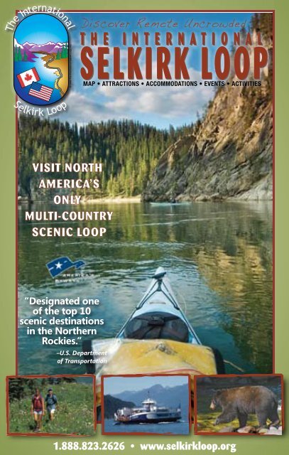
Discover Remote Uncrowded<br />
T T H H E E I I N N T T E E R R N N A A T T I I O O N N A A L<br />
L<br />
<strong>SELKIRK</strong> <strong>SELKIRK</strong> <strong>LOOP</strong><br />
<strong>LOOP</strong><br />
–U.S. Department<br />
of Transportation<br />
MAP • ATTRACTIONS • ACCOMMODATIONS • EVENTS • ACTIVITIES<br />
1.888.823.2626 • www.selkirkloop.org
Welcome to the<br />
InternatIonal SelkIrk loop<br />
Driving the <strong>International</strong> <strong>Selkirk</strong> <strong>Loop</strong> is<br />
truly a spectacular experience, as the 280mile<br />
(450 km) international scenic byway winds<br />
around the <strong>Selkirk</strong> Mountains through Idaho and<br />
Washington, USA and British Columbia, Canada.<br />
Often following lakes and rivers along the way,<br />
the <strong>Selkirk</strong> <strong>Loop</strong> leads visitors to the towns and<br />
waterways in an area brimming with outdoor<br />
recreation opportunities. Explore a wide variety<br />
of recreational activities, awe-inspiring sights and<br />
the stories of local history in a two-state, twocountry<br />
vacation. In fact, the <strong>Selkirk</strong> <strong>Loop</strong> has<br />
garnered heaps of recognition. Rand McNally<br />
selected it as one of five “Best of the Roads” for<br />
its 2009 atlas – both U.S. and Canadian editions.<br />
The U.S. Department of Transportation designated<br />
the <strong>Selkirk</strong> <strong>Loop</strong> an “All American Road”<br />
in 2005. And Sunset Magazine named it “The<br />
West’s Best Scenic Drive.” So put yourself in the<br />
driver’s seat for one fabulous drive chock full of<br />
Credits:<br />
Text & Editing: Carol Graham and<br />
Billie Jean Plaster<br />
Design & Layout: Keokee, Sandpoint, ID<br />
Printing: Journal Graphics, Portland, OR<br />
Cover Design: Laura White<br />
Cover Photograph: Kayaking on Pend<br />
Oreille River north of Metaline Falls,<br />
WA. (Jerry Pavia)<br />
2 www.selkirkloop.org<br />
RVing along the shores of Kootenay Lake (tim Cady)<br />
scenery and friendly towns on the <strong>International</strong><br />
<strong>Selkirk</strong> <strong>Loop</strong>!<br />
The book is organized into two sections.<br />
The first half of the <strong>Selkirk</strong> <strong>Loop</strong> Travel Guide<br />
contains U.S. communities, and the second half<br />
contains Canadian communities with an overview<br />
map in the middle. The communities appear in<br />
traveling order when driving the loop in a<br />
counterclockwise direction (recommended).<br />
C A N A D A<br />
BRITISH COLUMBIA<br />
B.C.<br />
The<br />
<strong>International</strong><br />
<strong>Selkirk</strong><br />
<strong>Loop</strong><br />
ALBERTA<br />
MONTANA<br />
The <strong>International</strong> <strong>Selkirk</strong> <strong>Loop</strong><br />
P.O. Box 920, Bonners Ferry, ID 83805 USA<br />
1-888-823-2626 • 208-267-0822<br />
www.<strong>Selkirk</strong><strong>Loop</strong>.org • info@selkirkloop.org
Driving the loop may begin from 12<br />
different highway approaches around the loop.<br />
Wherever you enter, look up the first community<br />
you come to in contents (at right) and begin<br />
Idaho Peak above Kootenay Lake (tim Cady)<br />
reading from that point, provided you are traveling<br />
in a counterclockwise direction.<br />
Each Super Side Trip is inserted into the<br />
guide where you would encounter an option to<br />
take a side trip. There are six of these side trips,<br />
and the travel guide provides mileages for each<br />
of these. Allow a minimum of two to three days<br />
to visit the <strong>International</strong> <strong>Selkirk</strong> <strong>Loop</strong>. More than<br />
half of the loop’s visitors spend four or more days<br />
to fully explore and experience this incredible<br />
region. “Sample Itineraries” can be found on our<br />
Web site, www.<strong>Selkirk</strong><strong>Loop</strong>.org.<br />
There is a handy directory of businesses at<br />
the back of the travel guide that is organized by<br />
U.S. and Canadian communities, type and<br />
activity. These businesses – listed with names<br />
and phone numbers – made the <strong>Selkirk</strong> <strong>Loop</strong><br />
Travel Guide possible. They all offer wonderful<br />
experiences. Be sure to tell them you are “Doin’<br />
the <strong>Loop</strong>.”<br />
Tips on Using this<br />
travel GuIde<br />
Contents<br />
u.S. deStInatIonS<br />
Athol, Idaho ..................................................... 18<br />
Bayview, Idaho ................................................ 18<br />
Blanchard, Idaho ............................................ 18<br />
Bonners Ferry, Idaho ..................................... 28<br />
Chewelah, Washington ....................................8<br />
Clark Fork, Idaho ............................................ 27<br />
Colville, Washington .........................................8<br />
Cusick, Washington ....................................... 10<br />
Hope, Idaho..................................................... 27<br />
Ione, Washington ..............................................7<br />
Metaline/Metaline Falls, Washington............5<br />
Moyie Springs, Idaho .................................... 27<br />
Newport, Washington ................................... 13<br />
Oldtown, Idaho ............................................... 13<br />
Priest Lake, Idaho ........................................... 15<br />
Priest River, Idaho........................................... 17<br />
Sagle, Idaho ..................................................... 18<br />
Sandpoint, Idaho ............................................ 19<br />
Spirit Lake, Idaho ............................................ 18<br />
Tiger, Washington .............................................7<br />
Troy/Libby, Montana ..................................... 27<br />
Usk, Washington ............................................ 10<br />
CanadIan deStInatIonS<br />
Ainsworth Hot Springs .................................. 45<br />
Balfour............................................................... 44<br />
Boswell .............................................................. 40<br />
Castlegar .......................................................... 55<br />
Crawford Bay ................................................... 40<br />
Creston ............................................................. 36<br />
Erickson............................................................. 35<br />
Fruitvale/Montrose ......................................... 55<br />
Gray Creek ....................................................... 40<br />
Harrop/Procter................................................ 44<br />
Kaslo .................................................................. 45<br />
Kitchener .......................................................... 35<br />
Kootenay Bay .................................................. 40<br />
Nelson ............................................................... 50<br />
New Denver ..................................................... 45<br />
Riondel .............................................................. 40<br />
Rossland ........................................................... 55<br />
Salmo ................................................................ 57<br />
Silverton............................................................ 45<br />
Slocan ............................................................... 45<br />
Trail .................................................................... 55<br />
Wyndell ............................................................. 40<br />
Yahk ................................................................... 35<br />
Ymir .................................................................... 57<br />
Other Information<br />
Border Crossing Information ..........................4<br />
Ferry Schedule ................................................ 42<br />
Map .............................................................32-33<br />
Member/Business Directory. .................58-63<br />
Winter Recreation .......................................... 34<br />
www.selkirkloop.org 3<br />
N
Metaline Guide Information Falls &<br />
WaShInGton<br />
Border CroSSInG InformatIon<br />
Individuals entering Canada: U.s. citizens need identification<br />
that proves two things: Citizenship and identity<br />
by way of a photo. Passports are required to reenter the<br />
United States. The following pieces of identification will<br />
serve as satisfactory proof of U.S. citizenship to enter<br />
Canada: U.S. passport or birth certificate (photocopies<br />
must be notarized), or certificate of naturalization or<br />
citizenship and photo ID such as a driver’s license.<br />
Note that restrictions pertain to fruits, vegetables,<br />
alcohol, tobacco and firearms. For more information on<br />
Canada Customs, look up http://www.britishcolumbia.<br />
com/information/details.asp?id=4<br />
Returning to Canada with Purchases/Goods/Gifts:<br />
Individuals returning to Canada after 24 hours can claim<br />
up to $50 CDN worth of goods without duty; after 48<br />
hours, the limit is $400, and after seven days, it is $750.<br />
Individuals entering the United States: Only passports<br />
or Western Hemisphere Travel Initiative (WHTI)-compliant<br />
documents are acceptable for entering the United<br />
States. WHTI-compliant documents are: U.S. PASSport<br />
card, Enhanced Driver’s License, NEXUS Card, or FAST<br />
Card. For more information on U.S. Customs, look up<br />
www.cbp.gov or www.passportinfo.com.<br />
Returning to the United States with Purchases/Goods/<br />
Gifts: Individuals returning to the United States in a 30-day<br />
period may bring $800 per person of approved items and<br />
one liter (33.6 fluid ounces) of alcohol per person without<br />
paying duty. Locally grown fruit from Creston, British<br />
Columbia, Canada is allowed. To learn what items are<br />
restricted go to www.cbp.gov.<br />
u.S. holIdayS &<br />
Important dateS In 2010<br />
New Year’s Day January 1<br />
Martin Luther King Jr. Day January 18<br />
President’s Day February 15<br />
Daylight Savings Time Begins March 14<br />
Good Friday April 2<br />
Easter Sunday April 4<br />
Memorial Day May 31<br />
Independence Day July 4<br />
Labor Day September 6<br />
Columbus Day October 11<br />
Daylight Saving Time Ends November 7<br />
Veterans Day November 11<br />
Thanksgiving Day November 25<br />
Christmas Day December 25<br />
4 www.selkirkloop.org<br />
Minors traveling with people<br />
who are not their parents<br />
(applies for Canada and<br />
U.S. entries): Must have<br />
written authorization<br />
from parents along<br />
with phone numbers<br />
and identification<br />
such as notarized copy of<br />
birth certificate. U.S. and Canadian<br />
citizens under age 16 need only present a birth<br />
certificate, Canadian Citizenship Card, or a naturalization<br />
certificate. Birth certificates can be an original, photocopy<br />
or certified copy.<br />
Traveling with pets: dog and cat owners may generally<br />
travel with healthy pets with a current rabies vaccination<br />
certificate (issued within the past 36 months).<br />
<strong>International</strong> Border Stations on the <strong>Loop</strong>:<br />
Washington: Metaline Falls, Highway 31 (509-446-<br />
4421) – open 8 a.m. to midnight; Frontier, Highway 25<br />
North (509-732-6215) – open 24 hours<br />
Idaho: Porthill, Highway 1 North (208-267-5309) –<br />
open 7 a.m. to 11 p.m.; Eastport, Highway 95 North<br />
(208-267-3966) – open 24 hours<br />
Canada: Nelway, Highway 6 (250-357-9940) – open 8<br />
a.m. to midnight; Rykerts, Highway 21 (250-428-2575)<br />
– open 8 a.m. to midnight; Kingsgate, Highway 3/95<br />
(250-424-5391) – open 24 hours; Paterson, Highway 22<br />
(250-362-7341) – open 24 hours<br />
CanadIan holIdayS &<br />
Important dateS In 2010<br />
New Year’s Day January 1<br />
Daylight Savings Time Begins March 14<br />
Good Friday April 2<br />
Easter Sunday April 4<br />
Victoria Day May 24<br />
Canada Day July 1<br />
Labor Day September 6<br />
Thanksgiving October 11<br />
Daylight Saving Time Ends November 7<br />
Remembrance Day November 11<br />
Christmas Day December 25<br />
Boxing Day December 26
Metaline • Metaline Falls<br />
surprising treasure awaits visitors of<br />
A the rural areas of northeastern Washington.<br />
From the international border to the junction of<br />
Highways 31 and 20, this segment of the <strong>Selkirk</strong><br />
<strong>Loop</strong> drive is also Washington’s North Pend<br />
Oreille Scenic Byway, one of this state’s prettiest<br />
scenic byways. Once accessible only by horseback<br />
or river expedition, Metaline Falls was one<br />
of the first pioneer settlements in Pend Oreille<br />
County. Pend Oreille is French for “ear pendant,”<br />
probably named by French fur traders after a<br />
native who wore such an earring.<br />
Metaline Falls is now home to a charming<br />
collection of well-preserved historical architecture<br />
including The Cutter Theatre and the<br />
The<br />
Cutter theatre<br />
302 Park Street, Metaline Falls, WA<br />
(509) 446-4108<br />
www.cuttertheatre.com<br />
• 1912 Schoolhouse on the<br />
National Register of<br />
historic Places<br />
• Rural School Museum<br />
• Art Gallery<br />
• Performing Arts Theatre<br />
Open Tues.-Fri. 9-4:30<br />
Metaline • Metaline Falls<br />
WaShInGton<br />
N<br />
Visit Boundary Dam’s Vista House accessed from the<br />
Crescent Lake Road, just south of the international border<br />
Below: Cycling across the Metaline Falls bridge (Ken<br />
Schueman)<br />
Washington Hotel. The town was the location<br />
for Kevin Costner’s film “The Postman.”<br />
With regular cultural productions at The<br />
Cutter Theatre and the town-wide Affair on<br />
Main Street over Labor Day weekend, it’s no<br />
surprise that Metaline Falls was named one of the<br />
100 Best Small Art Towns in America.<br />
This region, often called the “Forgotten<br />
Corner,” contains one of the most diverse<br />
populations of big game animals in the Lower 48.<br />
The Mill Pond historic site provides an interpretive<br />
walk with a trail connecting it to the Mill<br />
Pond Campgrounds. Nearby pristine Sullivan<br />
Lake features recently upgraded campground<br />
and picnic facilities. Contact the Sullivan Lake<br />
www.selkirkloop.org 5
Metaline • Metaline Falls<br />
WaShInGton<br />
“Absolutely<br />
breathtaking,<br />
just great.<br />
We met nice<br />
folks.”<br />
–Z. Johnson, Missoula,<br />
Montana<br />
www.seattle.gov/light/tours/boundary/<br />
509.446.3083<br />
6 www.selkirkloop.org<br />
Above: Visit the rural school museum at the Cutter<br />
Theatre in Metaline Falls<br />
Left: View of the Pend Oreille River along the North<br />
Pend Oreille Scenic Byway (Carrie Sunstrum)<br />
Ranger Station at 509-446-2681 for camping in<br />
the area, a list of local day hiking and sightseeing<br />
trips as well as an interesting historical display.<br />
Take a guided tour of Gardner Cave,<br />
Washington state’s third-longest limestone cave,<br />
located 11 miles north of Metaline Falls in Crawford<br />
State Park. Tours are conducted in the<br />
summer months. The cave is closed on Tuesdays<br />
and Wednesday<br />
FeSTIvaLS and evenTS<br />
metalIne – metalIne fallS<br />
July BBQ in Metaline Park<br />
September The Affair on Main Street Art, Craft &<br />
Culture Festival<br />
December Deck the Falls Winter Festival<br />
North Pend Oreille Chamber - Message Phone<br />
(509) 446-4108<br />
Seattle City Light’s Boundary Hydroelectric<br />
Project is located just 110<br />
miles north of Spokane, WA. Explore<br />
the dam, recreation/camping area<br />
and boat launch. – Guided tours of<br />
Boundary are available Memorial<br />
Day through Labor Day, Thursdays<br />
through Mondays from 10:30 a.m.<br />
to 4:30 p.m. Great panoramic views of<br />
the Boundary Project are found at the<br />
Vista House on the east bank of the<br />
Pend Oreille.
Ione • Tiger<br />
The story of Ione is one steeped in legends<br />
of the timber industry, the railway and<br />
the lore of the Pend Oreille River. Follow the story<br />
of the mills, mines and railroads of yesteryear by<br />
stopping at designated points of interest along<br />
Highway 31 marked as North Pend Oreille<br />
Scenic Byway.<br />
In 1901, the community built its first sawmill.<br />
Eight years later, the Panhandle Lumber Company<br />
employed more than 700 men. The arrival<br />
of the railroad in 1909 was almost as vital to the<br />
region’s survival. But none of it would be here if it<br />
weren’t for the Pend Oreille River.<br />
Today, the community’s residents celebrate<br />
the Pend Oreille’s bounty every July, when Down<br />
River Days arrive. The events are marked by<br />
family-friendly, river-based activities including<br />
“water skipping” of snowmobiles across the Pend<br />
Oreille River. Ione has a lovely day-use park<br />
along the water’s edge. The Lions Club Excursion<br />
Train Ride showcases some of the most<br />
stunning fall scenery in the Pacific Northwest<br />
as it runs along the Pend Oreille River between<br />
Ione and Metaline Falls six weekends a year. At<br />
Metaline Falls, the local drama club stages a train<br />
robbery while the locomotive is turned around.<br />
Sweet Creek Rest Area also offers a picnic<br />
site, interpretive panels and a hiking trail to Sweet<br />
Creek Falls.<br />
Just north of Ione is Box Canyon Dam.<br />
The site provides tours, camping, a swimming<br />
pond and is a great place to have a picnic. Stop<br />
by the Meadow Lake Wildlife Observatory<br />
located west of Ione, where a dismantled fire<br />
lookout was reconstructed on this site as a wild-<br />
Ione • Tiger<br />
WaShInGton<br />
Lions Club Train Excursion as seen from the Box Canyon<br />
Dam scenic overlook north of Ione (David Winkler)<br />
life-viewing tower. At the junction of Highways<br />
31 and 20, the Tiger General Store is all that<br />
remains of this once-thriving pioneer town. Peer<br />
into the past at the store’s museum with early<br />
history of the region, including a mining display<br />
and an on-site blacksmith shop containing a lot<br />
of original items. A state designated rest area is<br />
open Memorial Weekend through September.<br />
At the junction of Highways 31 and 20, turn<br />
west to go on the <strong>Selkirk</strong> <strong>Loop</strong>’s Flowery Trail –<br />
Little Pend Oreille Super Side Trip (page 8).<br />
FeSTIvaLS and evenTS<br />
Ione<br />
February <strong>Selkirk</strong> Trailblazers Snowmobile Poker Run<br />
March St. Patrick’s Day Parade<br />
July Down River Days River Festival<br />
2010-B<br />
Riverview Motel<br />
Clean, quiet and comfortable<br />
on the Pend Oreille River<br />
North Pend Oreille Chamber<br />
(509) 446-4108<br />
AC/heaters, refrigerators,<br />
microwaves, cable TV, In-room coffee<br />
wireless internet, boat docks.<br />
Great recreational opportunities.<br />
120 Riverside Ave. & Hwy 31, Ione WA<br />
For Reservations<br />
www.selkirkloop.org 7<br />
N<br />
509.442.2990
Flowery Trail-Little Pend Oreille Super Side Trip<br />
WaShInGton<br />
Colville • Chewelah<br />
80 mIleS / 129 km<br />
This scenic mountain<br />
route leads drivers up<br />
and over one of the ridges<br />
of the <strong>Selkirk</strong> Mountain<br />
range twice, offering stellar<br />
views. The roadway was resurfaced<br />
recently and is suitable for any vehicle.<br />
More than a dozen unique and varied barns are<br />
visible along this route.<br />
This Super Side Trip begins at the junction<br />
of Highways 20 and 31 at Tiger. Turn west onto<br />
Highway 20 toward Colville. Take a break along<br />
the glittering chain created by the Little Pend<br />
Oreille Lakes system at the Frater Lake Rest<br />
Area. Several Forest Service campgrounds exist<br />
near these lakes. Stop and take a short walk to<br />
view Crystal Falls. Contact the Colville National<br />
Forest at 509-684-7000 for information<br />
on other camping available in the area.<br />
Seven miles east of Colville on Highway 20<br />
is the Little Pend Oreille National Wildlife<br />
Refuge. It’s the only mountainous, mixed-conifer<br />
forest refuge in the National Wildlife Refuge<br />
system. Take the auto tour route through the<br />
refuge for a great overview. You’ll see older forests<br />
consisting of pines and other conifers. More<br />
than 200 nesting and foraging migratory bird<br />
species, 58 mammal species, and 14 reptile and<br />
amphibian species use the refuge’s 40,198 acres<br />
of forests, streams and wetlands seasonally.<br />
At the junction of Highway 20 and Highway<br />
395 is one of Washington’s oldest cities, Colville,<br />
known as a leader in historical preservation with<br />
a large museum and the “Keller House,” a wellappointed<br />
reminder of the turn of the century.<br />
Stevens County was recently awarded a “Preserve<br />
Indoor Pool and Hot Tub • Complimentary Breakfast<br />
Cable TV 24 Hour Staff<br />
Comfort Inn<br />
Colville, WA<br />
166 NE Canning Drive<br />
509-684-2010<br />
www.choicehotels.com/hotel/wa717<br />
8 www.selkirkloop.org<br />
Sunrise in the Colville Valley (Jerry Pavia)<br />
America Presidential Award,” one of only two<br />
counties in Washington to receive this award.<br />
Take a walking tour through the historic downtown<br />
business district. Visual and performing<br />
arts abound with a pavilion in the 18-acre Yep<br />
FeSTIvaLS and evenTS<br />
ColvIlle<br />
January Colville Drifters Snowmobile Club Gold<br />
Rush Fun Day<br />
Winterfest and Wellness<br />
March Home, Garden and Travel Expo<br />
Woodland Theater<br />
April Wild Turkey Daze<br />
May Stevens County Historical Museum Opens<br />
Farmers Market<br />
Mayors Golf Tournament<br />
June Garden Tour<br />
Colville PWRA Rodeo<br />
July Sidewalk Sale/Street Fair<br />
tiger tri race<br />
August Rendezvous Days<br />
Northeast Washington Fair<br />
October Kiddie Parade<br />
Moonlight Madness<br />
December Home for the Holidays<br />
Colville Chamber<br />
(509) 684-5973 • www.colville.com
Flowery Trail-Little Pend Oreille Super Side Trip<br />
WaShInGton<br />
Kanum City Park<br />
– host to several<br />
major events<br />
during the spring<br />
and summer<br />
months. Colville<br />
has its own 18hole<br />
public golf<br />
course, Dominion<br />
Meadows.<br />
Nearby Lake<br />
Roosevelt, accessed<br />
by a short<br />
Great Horned Owl (tim Cady) drive farther west<br />
at Kettle Falls, is the<br />
area’s largest water sports playground. Heading<br />
south on Highway 395 toward Chewelah, visitors<br />
travel through a lovely wide valley of mixed<br />
cultivated fields and coniferous forests.<br />
Chewelah has approximately 2,400<br />
residents, and displays a pleasant blend of the<br />
past and future. As far back as the early 1870s,<br />
Chewelah established itself as an agricultural and<br />
later a commercial center with the opening of<br />
manganese mines during World War I. With its<br />
FeSTIvaLS and evenTS<br />
CheWelah<br />
February Lions Club Cork & Keg Tasting<br />
Chewelah Arts Guild Annual Art Festival<br />
PACA EVENT–local Performing Arts event<br />
March Alice in Wonderland, StageTime Theatre<br />
School Production<br />
May Downtown Chewelah Car Show<br />
Park Avenue Players Theater Production<br />
Nostalgia Days Antique/Classic Cars &<br />
Quilt Show<br />
June Chewelah Arts Guild Art in the Garden Tour<br />
Mistequa Motorcycle Show<br />
July Chataqua Arts & Crafts Festival<br />
Chataqua Challenge Fun Run 5K & 10K<br />
August James Dean Days Car Show, Chewelah Park<br />
September Spokane Symphony performance,<br />
Chewelah Peak Learning Center<br />
October Snowmobile Grass Drags<br />
Tour De Rock Bike Ride, 49 Degrees North<br />
Lions Club Bike Tour<br />
November Park Avenue Players Theater Production<br />
49 Degrees North opens Thanksgiving<br />
weekend<br />
December Festival of Lights - Santa Social - Tree of<br />
Sharing<br />
Stagetime Theater School Production<br />
Chewelah Chamber<br />
(509) 935-8595 • www.chewelah.org<br />
moderate climate, dry land and irrigated farming,<br />
ranching and dairies were mainstays.<br />
Chataqua, a four-day arts festival, is<br />
one of Chewelah’s major events, always the second<br />
weekend in July. Held on eight-plus acres<br />
at Chewelah City Park, Chataqua features craft<br />
exhibits, free entertainment, food and a traveling<br />
carnival. There is also a fine historical museum,<br />
antique car museum and casino to<br />
explore. Chewelah is home to the only 27 hole<br />
golf course in Eastern Washington, Chewelah<br />
Golf & Country Club.<br />
Turn east onto the Flowery Trail Road from<br />
Chewelah and travel 10 miles to the top of the<br />
pass at 4,046 feet where 49 Degrees North<br />
and Chewelah Peak Learning Center offer a<br />
stay-and-play family oriented ski hill with miles of<br />
groomed trails. Snowmobiling and cross-country<br />
skiing adventures provide plenty of additional cold<br />
weather action. In the warm weather months, take<br />
advantage of the area’s scenic back roads and<br />
trails for bike tours, mountain biking and hiking.<br />
This route rejoins to the main <strong>Selkirk</strong> <strong>Loop</strong><br />
route at Usk. Turn south onto Highway 20 south<br />
toward Newport.<br />
w ww.selkirkloop.org 9<br />
N
USk • Cusick<br />
WaShInGton<br />
Usk • Cusick<br />
The beginnings for these small communities<br />
started with two friends. Cusick was founded<br />
by Joe Cusick in the mid-1880s. Usk was established<br />
by Cusick’s good friend George H. Jones.<br />
The two competed for everything – from post offices<br />
and steamboat service to baseball bragging<br />
rights. Today there is a lovely riverwalk between<br />
the two communities, with a public park and boat<br />
launch at Cusick’s end of this trail.<br />
Along Highway 20 river timbers are seen<br />
standing as silent reminders of the heyday of logging<br />
when the Diamond Match Company, then<br />
located in Cusick, created a heavy demand for<br />
white pine. The Pend Oreille River provided the<br />
transportation for millions of feet of timber, using<br />
For Sale<br />
B eautiful<br />
rV lotS<br />
• Fabulous<br />
Clubhouse<br />
• Great Fishing<br />
& Boating<br />
•Super Buys<br />
Available Now<br />
Call 877-402-9785<br />
or 208-691-7257<br />
1432 Lenora Dr. Usk, WA<br />
www.skookum-rendezvous.com<br />
10 www.selkirkloop.org<br />
Above: A large variety of barns can be seen in the area.<br />
This one was captured with storm clouds rolling in (tim<br />
Cady)<br />
FeSTIvaLS and evenTS<br />
uSk - CuSICk<br />
February Tundra Swan Migration<br />
July Pend Oreille River Poker Paddle<br />
August Salish Fair and Powwow/Kalispel Tribe<br />
Reservation<br />
Pend Oreille Fair and Rodeo<br />
Newport/Oldtown Chamber<br />
www.newportoldtownchamber.org • (877) 818-1008<br />
these pilings to guide, sort and hold the timber<br />
prior to processing.<br />
Today, the biggest competition is amongst<br />
the region’s incredible birdlife population. The<br />
pilings and surrounding timber along the river is<br />
now home to hundreds of osprey and eagles.<br />
Huge flocks of tundra swans migrate through<br />
Cusick and Usk in February and March.<br />
The region’s most fascinating points of<br />
interest await on the 4,600-acre Kalispel Tribal<br />
Lands, across the Pend Oreille River from Usk.<br />
The tribe operates a buffalo ranch – an excellent<br />
viewpoint for visitors along LeClerc Road.<br />
The tribe also operates a bass fish hatchery<br />
that may be visited by advance reservation.<br />
Farther north on LeClerc Road, the Manressa<br />
Grotto system of caves is a glacially formed,
above-ground cave system used for religious<br />
ceremonies by early American Indians and<br />
missionaries. There is a winding dirt trail to the<br />
cave which affords spectacular views of the Pend<br />
Oreille River and surrounding mountains.<br />
Just north of Cusick on the west side of the<br />
road, watch for a small sign to the Batey-Bould<br />
ORV Area. There is trailhead parking with facili-<br />
Visit The Camas Center<br />
For Community Wellness<br />
There is something for every member of the<br />
family including a fitness center, aquatic area,<br />
walk-in child care, teen room, deli and meeting<br />
rooms. We also offer a medical and dental clinic<br />
open to the public. At the heart of this operation<br />
is the belief that a healthy and active lifestyle<br />
brings a long, prosperous life.<br />
www.kalispeltribe.com • (509) 447-7122<br />
Hours<br />
Usk • Cusick<br />
WaShInGton<br />
River pilings are all that remain of the Diamond Match<br />
Company’s extensive log holding area at Cusick (deana<br />
edmiston)<br />
ties. Excellent motorcycle and ORV riding in this<br />
large area of the Colville National Forest connects<br />
to more off road riding on the Little Pend<br />
Oreille ORV trail system to the northwest.<br />
MON-FRI 6AM – 8PM SAT 8AM – 8PM SUN 9AM – 6PM<br />
www.selkirkloop.org 11<br />
N
The CiT y of NewporT<br />
It’s a wild ride<br />
Rodeos, Concerts in the Park, Lavender Festival and<br />
hot rod car shows are some of the wild things that<br />
happen here in Newport, the rest of the year we are<br />
just a quiet city with antique stores, camping, hiking,<br />
fishing, hunting, snowmobiling and a friendly<br />
welcome to all.<br />
Watch for these Special Events:<br />
PWRA Rodeo<br />
➢ Rodeo Parade<br />
➢ Carnival<br />
➢ Bull-A-Rama<br />
➢ Lavender Festival<br />
➢ Iris Gardens<br />
➢ Poker Paddle<br />
➢ Run for the Arts<br />
➢ Car Shows<br />
➢ Earth Market<br />
➢ Operation Kill Boredom<br />
➢ Christmas Celebration<br />
City of Newport<br />
200 S. Washington Ave.<br />
Newport, WA 99156<br />
(509) 447-5611<br />
www.newport-wa.org<br />
Newport/Oldtown Chamber of Commerce • (509) 447-5812 • www.newportoldtownchamber.org
newport • Oldtown<br />
WaShInGton / Idaho<br />
newport • Oldtown Lupines at Calispell Creek (tim Cady)<br />
Newport, located at the junction of U.S.<br />
Highway 2 and Washington State Highway<br />
20, features historic Washington Avenue as its<br />
“main street,” where some shops display a plaque<br />
showing the name of the original business and<br />
its date. Many buildings are constructed of<br />
locally made bricks. Plan to visit the Newport /<br />
Oldtown Chamber of Commerce Visitor Center<br />
and the adjacent Pend Oreille County Historical<br />
Society Museum to pick up the booklet “Historic<br />
Tour of Newport.” Both the visitor center and<br />
museum are located in Centennial Plaza, which<br />
was built to celebrate the Washington State<br />
Centennial in 1989.<br />
The museum’s exhibits in several outbuildings<br />
showcase the area’s history. Look for the<br />
“Big Wheel,” a 16-foot, steam-driven sawmill<br />
generator, and the gazebo with picnic area, summer<br />
flower displays and winter holiday lights.<br />
Newport is the county seat of Pend Oreille<br />
(pon-duh-ray) County, Washington’s 39th and<br />
youngest county. Formed in 1911, it was originally<br />
part of Stevens County. The town began as<br />
Newport, Idaho, in 1889 when Mike Kelly erected<br />
a log building on the banks of the Pend Oreille<br />
River. In 1892, a post office was added to Kelly’s<br />
store, and mail was brought in from Rathdrum,<br />
Idaho, via Blanchard. Original transportation<br />
depended on the riverboats until the Idaho and<br />
Washington Northern Railroad was extended<br />
from Newport to Metaline Falls in 1910. The<br />
arrival of the Great Northern Railroad in 1892<br />
started Newport’s move from the Idaho side to<br />
the Washington side of the state line. Today, the<br />
businesses and residential areas are divided by<br />
the state line. Oldtown, Idaho, is also the start<br />
Salish Pow-Wow (tim Cady)<br />
www.selkirkloop.org 13<br />
N
newport • Oldtown<br />
WaShInGton / Idaho<br />
Hydro Races in Oldtown (tim Cady)<br />
of the Idaho Scenic Byway Panhandle Historic<br />
Rivers Passage on Highway 2.<br />
In summer, the air is filled with the scent<br />
of lavender in this region. In early July wander<br />
down to the Newport City Park to take in the<br />
Pend Oreille Valley Lavender Festival, host<br />
to more than 60 artisan vendors. After taking<br />
in Newport’s charming downtown district, take<br />
the time to explore the natural splendor of the<br />
surrounding Colville National Forest. Check with<br />
the Colville Ranger Station at 509-447-3129,<br />
FeSTIvaLS and evenTS<br />
neWport / oldtoWn<br />
May-October Farmers Market<br />
May Regional Yard Sale, Newport/Oldtown/<br />
Priest River<br />
June PWRA Rodeo and Carnival<br />
July Hydro races<br />
Pend Oreille Valley Lavender Festival<br />
Pend Oreille River Poker Paddle<br />
Bull-a-Rama<br />
July-August WSU Master Gardener Garden Tours<br />
County Fair and Rodeo<br />
September Heritage days<br />
4th Annual Newport Music Festival<br />
Newport/Oldtown Chamber<br />
www.newportoldtownchamber.org • (877) 818-1008<br />
14 www.selkirkloop.org<br />
Fun at the Pend Oreille Valley Lavender Festival at<br />
Newport City Park (Jerry Pavia)<br />
on Highway 20 just north of Newport, to discover<br />
a host of year-round recreational opportunities<br />
including the Upper and Lower Wolf Trail hikes,<br />
only minutes from downtown. Camping, boat<br />
launch and hiking are available at Pioneer Park<br />
east of Newport along the Pend Oreille River.
Priest Lake<br />
T urn<br />
north on Highway 57 in the town of<br />
Priest River for a scenic drive into the heart<br />
of the <strong>Selkirk</strong> Mountains. Priest Lake earns<br />
its “Idaho’s Crown Jewel” status because of<br />
the clarity and purity of its water. The pristine,<br />
19-mile-long lake coupled with the surrounding<br />
mountains offer a myriad of year-round<br />
recreational opportunities. In the summer season,<br />
the location and sheer size of Priest Lake afford<br />
ample space for all water sports. Explore<br />
the 72-mile shoreline with its numerous white,<br />
sandy beaches by powerboat, sailboat, canoe,<br />
kayak or personal watercraft, and include visits<br />
to the lake’s seven islands. Is fishing your forte?<br />
Priest Lake is renowned for trophy-sized lake<br />
trout, aka mackinaw.<br />
Upper Priest Lake lies north of Priest Lake<br />
and offers visitors a unique experience. This<br />
1,300-acre lake and surrounding mountains are<br />
a federally designated Scenic Area. As such,<br />
the area is restricted from development and<br />
remains as it has been from time immemorial.<br />
Resorts f Cabinsg B & B g Dining<br />
Sandy Beaches g Recreational Rentals<br />
www.priestlake.org<br />
888-774-3785<br />
Priest Lake<br />
Idaho<br />
The setting sun on Priest Lake (Jerry Pavia)<br />
Upper Priest Lake is accessible only via hiking<br />
and biking trails or a 2.5-mile, no-wake waterway<br />
named The Thoroughfare. The Thoroughfare and<br />
Upper Priest Lake are ideal playgrounds for<br />
the kayaker and canoeist.<br />
The main campgrounds on the east<br />
shore are Lion Head and Indian Creek state<br />
parks; phone 208-443-2200 or 208-443-6710 for<br />
information and reservations. In the early 1920s,<br />
Nell Shipman (1892-1970) built a movie camp<br />
called Lion Head Lodge. This actress produced<br />
her own films and maintained a menagerie of<br />
wild animals, using Priest Lake’s wilderness setting<br />
as a natural filming location. Other designated<br />
camping areas accessible only by boat are also<br />
available. For Forest Service campgrounds in the<br />
area, contact the Priest Lake Ranger District<br />
at 208-443-2512 or Reserve USA at 877-444-<br />
6777 for reservations.<br />
In addition to water sports activities, there<br />
are miles of hiking and biking trails surrounding<br />
the lake. Walk among giant cedars<br />
www.selkirkloop.org 15<br />
N
Priest Lake<br />
Idaho<br />
on the Hanna Flats interpretive trail located<br />
at approximately milepost 32 on Highway 57.<br />
Only 14 miles north of Nordman is the unique<br />
Roosevelt Grove of Ancient Cedars and<br />
Granite Falls. The trees range from 4 to 12 feet<br />
in diameter and reach heights of 150 feet, some<br />
as old as 2,000 years. While out for a hike, look<br />
for Priest Lake’s world-famous huckleberry,<br />
found in August to mid-September. Or foray into<br />
the woods to look for fall mushrooms; 450-plus<br />
species are present in the area. Duffers may want<br />
to try a round of 18 holes at Priest Lake Golf<br />
Club, a challenging and beautiful course that<br />
turns into a Nordic center in winter with an everexpanding<br />
cross-country ski trail system with<br />
more than 70 kilometers.<br />
Visit the Priest Lake Museum on Luby Bay<br />
near Nordman, situated in a log building built by<br />
the CCCs in 1935. Catch a glimpse of the region’s<br />
early days through revolving interpretive displays.<br />
Destination resorts, RV parks, B&Bs, and<br />
numerous campgrounds, including island campsites,<br />
provide an abundance of accommodations.<br />
Full-service marinas provide boat moorage, rentals<br />
and repairs. Grocery stores, gift shops, galler-<br />
16 www.selkirkloop.org<br />
FeSTIvaLS and evenTS<br />
prIeSt lake<br />
February U.S. Pacific Coast Championship Sled Dog<br />
races, USFS Airstrip<br />
April Loggers Day at Nordman<br />
May Spring Festival, Memorial Day Weekend<br />
July Fireworks Display, area resorts<br />
Annual Ice Cream Social, Coolin<br />
August Huckleberry Festival<br />
September Annual Dry Rot Wooden Boat Breakfast &<br />
Parade, Reeder Bay<br />
Priest Lake Yacht Club Gin Fizz, Luby Bay<br />
6th Annual Boat Poker Run, Cavanaugh Bay<br />
October Autoberfest Annual Classic & Antique Car<br />
Show<br />
Priest Lake Chamber<br />
www.priestlake.org • (888) 774-3785<br />
ies, several restaurants and other guest services<br />
are conveniently located around the lake.<br />
Priest Lake is also becoming an everincreasing<br />
popular winter season recreation<br />
area. The area boasts some 400-plus miles of<br />
groomed snowmobile trails amidst more than<br />
500,000 acres of public land for off-trail<br />
riding. Numerous meadows, bowls and ridges<br />
are ideally suited for family fun, while muscle machine<br />
aficionados are challenged by hill climbs.<br />
Leonard Paul Store<br />
Established in 1906 on the Eastside, in Coolin Bay<br />
Historic General Mercantile<br />
Priest Lake apparel & gifts • We also have licenses<br />
Priest Lake’s only<br />
Fresh to go Deli<br />
Specializing in:<br />
Gourmet Sandwiches,<br />
soups,<br />
huckleberry pies<br />
Huckleberry Huckl products<br />
fine wines & liquor<br />
grocery, and espresso<br />
scoop Ice Cream<br />
LIVE WEB CAM<br />
WiFi Hot Spot • Coolin, ID 208-443-2463<br />
www.theleonardpaulstore.com
Priest River<br />
L ocated<br />
at the confluence of the Priest<br />
and Pend Oreille rivers, the town of Priest<br />
River is conveniently centered an hour away<br />
from Spokane, Wash., and Coeur d’Alene, Idaho.<br />
Highway 2 from Oldtown through Priest River<br />
and into Sandpoint is the Idaho Scenic Byway<br />
“Panhandle Historic Rivers Passage.”<br />
The town’s first sawmill was built in 1897.<br />
Logs were driven down the Priest River to sawmills<br />
from 1901 to 1949. View one of the last of<br />
the riverboats, called “bateaux,” from the Diamond<br />
Match Company at the Priest River Museum<br />
and Timber Education Center. Timber continues<br />
to be the basis of the town’s economy.<br />
Take a walking tour of historic downtown<br />
and see some of the beautifully renovated<br />
buildings, such as the Beardmore Block, a 1922<br />
structure restored to its former glory.<br />
Priest River is a recreational paradise with<br />
top-notch boating, hunting, fishing, skiing, golfing,<br />
snowmobiling, camping, cross-country skiing<br />
and hiking all nearby. Stop in at the Albeni Falls<br />
Dam Visitor Center, just west of Priest River<br />
on Highway 2, to take a tour in summer. The<br />
Priest River Development<br />
Corp. can help you relocate<br />
your business to beautiful<br />
Priest River by offering<br />
low-cost, light industrial land.<br />
Call to view the available<br />
spaces or land in the Priest<br />
River Industrial Park.<br />
U.S. Army Corps of<br />
Engineers maintains<br />
three campgrounds<br />
in the area: Albeni<br />
Cove, Priest River<br />
Mudhole and the<br />
newly redone Riley<br />
Creek. For reservations<br />
call Reserve<br />
USA at 877-444-<br />
6777. For the rock<br />
climbing enthusiast,<br />
Riverside Rocks, six<br />
miles east of Priest<br />
River has six technical<br />
climbs on the river<br />
side of the road. More<br />
information can be<br />
Priest River<br />
Idaho<br />
Visit the historic<br />
district to admire the<br />
restoration of some<br />
notable buildings such<br />
as the Beardmore (Carol<br />
Graham)<br />
found in the “Climber’s Guide to North Idaho” by<br />
Thaddeus Laird.<br />
A fun, 9-hole golf course and driving range<br />
at The Ranch Club west of Priest River also<br />
includes the Restaurant and Pizza House. The<br />
gorgeous Priest River offers 42 miles of floatable<br />
water ranging from slow-moving, laid-back sightseeing<br />
to fast-moving, white-knuckled Class III<br />
rapids. Pend Oreille River holds largemouth bass<br />
as well as brook, brown, rainbow and cutthroat<br />
trout; walleye; whitefish; and various panfish.<br />
FeSTIvaLS and evenTS<br />
prIeSt rIver<br />
May May Day Community Yard & Sidewalk Sale<br />
July Fireworks over the Pend Oreille River<br />
timber days Celebration<br />
August Chamber’s Annual High Water Watch Open<br />
Golf Tournament<br />
October Oktoberfest<br />
Priest River Chamber<br />
www.priestriverchamber.net •(208) 448-2721<br />
Free Continental Breakfast & High Speed Internet<br />
King & Queen Rooms, Jacuzzi Suites<br />
Visit us at www.eaglesnestmotel.com<br />
Handicap<br />
Pet Rooms<br />
Accessible<br />
Available<br />
Rates Start at<br />
$50<br />
www.selkirkloop.org 17<br />
N
South Lakes Super Side Trip<br />
Idaho<br />
Blanchard • Spirit<br />
Lake • athol •<br />
Bayview • Sagle<br />
60 mIleS / 98 km<br />
The South Lakes route takes<br />
visitors within close proximity to the area’s<br />
pristine large and small lakes. Starting this side<br />
trip from Newport / Oldtown, follow Highway<br />
41 south. Just west of the small community<br />
of Blanchard, Stoneridge Resort is located<br />
within StoneRidge Recreational Community,<br />
which boasts a par 71, 19-hole golf course and<br />
restaurant.<br />
The community of Spirit Lake and the serene<br />
4.5-mile long Spirit Lake offers easy access<br />
at three public boat ramps. A few miles south of<br />
Spirit Lake, turn east on Highway 54, traveling 11<br />
miles (18 km) to the junction of Highways 54 and<br />
95. The small village of Athol is a good place<br />
to pick up quick supplies before heading east to<br />
Farragut State Park situated on the southern<br />
shores of Lake Pend Oreille. Camping cabins, full<br />
hookups and tenting sites are available here. It’s<br />
Idaho’s second largest state park and has a<br />
fascinating military history. A few minutes south<br />
of the Athol junction is Silverwood, the Northwest’s<br />
largest theme park, with more than 65<br />
rides, shows and attractions, including four roller<br />
coasters, a steam locomotive and a water park.<br />
RV/tent camping is available on site.<br />
Visit nearby Bayview with its towering<br />
mountains and steep, rocky cliffs that have become<br />
a haven for mountain goats, eagles and<br />
other alpine wildlife. Bayview is a favorite location<br />
for all types of boat moorage. The bay is also<br />
home to several float-house communities, which<br />
lends a feeling of an ocean-side resort to the area.<br />
Returning to Highway 95, head north 14<br />
18 www.selkirkloop.org<br />
Left: Barn in Blanchard near the StoneRidge Golf<br />
Course (tim Cady)<br />
Above: Spirit Lake (tim Cady)<br />
miles to Cocolalla Lake, on the west of the<br />
highway, with easy year-round access to fishing<br />
and camping. A few miles farther is Round Lake<br />
State Park with camping, fishing and hiking.<br />
Return to Highway 95 and continue north<br />
to Sagle, and turn right at Sagle Road for 11.8<br />
miles (18.9 km) to visit the new 16,000-squarefoot<br />
Bird Aviation Museum and Invention<br />
Center at Glengary Bay. View aviation and World<br />
War II memorabilia collected by world-famous<br />
Dr. Forrest Bird. Return to Highway 95 and head<br />
north to Lakeshore Drive. Turn west to explore<br />
the WaterLife Discovery Center with developed<br />
interpretive wetland exhibits and trails.<br />
FeSTIvaLS and evenTS<br />
SpIrIt lake<br />
January Winter Fun Fest<br />
June The Big Back’n Lawn Mower Drag Race<br />
July Independence Day Parade, Live Music and<br />
Vendors<br />
August Blues Fest<br />
September Wine Tasting, Music & Auction, Labor Day<br />
Parade, Mountain Bike Ride, and Car &<br />
Motorcycle Show<br />
Spirit Lake Chamber of Commerce<br />
www.spiritlakechamber.com • (208) 623-3411<br />
N
Sandpoint<br />
Sandpoint’s experienced a lot of buzz in recent<br />
years. Sunset magazine voted Sandpoint the<br />
“West’s Best Small Town.” Outside magazine<br />
named it one of the nation’s “Top 10 Great<br />
Outdoor Towns.” The New York Times called<br />
Sandpoint “a sporting paradise.” USA Today<br />
described Sandpoint as a “Norman Rockwellmeets-Ansel<br />
Adams classic, brought to life<br />
every summer.”<br />
Just an hour north of Coeur d’Alene,<br />
Sandpoint is about 90 minutes away from the<br />
closest international airport, found at Spokane,<br />
Wash. Driving from the south into Sandpoint on<br />
Highway 95 sets the stage for a dramatic entrance.<br />
Travelers cross the two-mile Long Bridge<br />
to reach Sandpoint, sitting on the northwestern<br />
shore of Lake Pend Oreille, (pronounced ponduh-ray)<br />
the second-largest freshwater lake<br />
west of the Mississippi. Lake Pend Oreille holds<br />
Sandpoint<br />
Idaho<br />
Just a block from downtown Sandpoint lies City Beach,<br />
a center for summer activities and easy lake access<br />
(Marie-Dominique Verdier)<br />
the world record for a kamloops trout caught<br />
in the late 1940s. Many fishing charters operate<br />
on the lake. The average size trout is around 12<br />
pounds, but local derby winners boast catches<br />
topping 20 pounds. The lake is 43 miles long,<br />
up to 6 miles wide and has depths of more than<br />
1,000 feet, offering a myriad of fun activities.<br />
Windsurf, kayak or simply swim in the beautiful<br />
clear water. City Beach Park at the end<br />
of Bridge Street, in the heart of downtown, has<br />
beautiful sandy beaches with lifeguards bordered<br />
by a lovely park with barbecue pits, tennis and<br />
volleyball courts, and a public boat launch. Get<br />
out on the water and learn about the area’s history<br />
and geology on a daily tour with Lake Pend<br />
Oreille Cruises, departing from City Beach.<br />
www.selkirkloop.org 19<br />
N
Sandpoint<br />
Idaho<br />
High atop the <strong>Selkirk</strong> Mountains above<br />
Sandpoint is year-round mountain adventure<br />
with world-class accommodations. Schweitzer<br />
Mountain Resort is the Inland Northwest’s<br />
largest ski resort with 2,900 acres of terrain.<br />
Nordic and snowshoe trails, snowmobile and<br />
backcountry tours offer endless adventure.<br />
Ride the lift in the summer to get to the top for<br />
spectacular views all the way to Canada and<br />
Montana, then hike or mountain bike on the<br />
many trails back down to the village.<br />
With the population at about 8,000,<br />
Sandpoint impresses visitors not only with the<br />
scenery but also the friendliness of the townsfolk<br />
and the casual pace of life here. Sandpoint<br />
is the <strong>Selkirk</strong> <strong>Loop</strong>’s largest U.S. town. There<br />
are designated bicycling paths both south<br />
and west of town offering more than 12 paved<br />
miles of peaceful peddling for the whole family.<br />
The Bonner County Historical Museum<br />
is a wonderful place to learn about the area’s<br />
first settlers and native peoples. Next to the<br />
museum is the Native Plant Arboretum at<br />
Waterfront dining<br />
fresh seafood,<br />
steaks, salads<br />
Breakfast, Lunch, Dinner<br />
Open 7 days/week,<br />
year-round<br />
sandpoint, idaho<br />
58 Bridge street at City BeaCh<br />
208.255.7558<br />
www.Cafetrinitysandpoint.Com<br />
20 www.selkirkloop.org<br />
Above: The historic Panida Theater is a central feature<br />
downtown (Carol Graham)<br />
Lakeview Park that includes a wild medicinal<br />
herb collection. Three national forests are easily<br />
accessible from Sandpoint: Idaho Panhandle,<br />
Colville and Kootenai national forests. Stop in at<br />
the Sandpoint Ranger Station west of town
“Very scenic, unhurried<br />
area, friendly people.”<br />
–S. Hennings, Papillion, Nebraska<br />
on Highway 2 or call 208-263-5111 for maps to<br />
hundreds of miles of outstanding hiking, backcountry<br />
camping and mountain bike trails.<br />
Truly an arts town, Sandpoint has close<br />
to two dozen galleries located in town and the<br />
surrounding area. Each summer the Festival<br />
at Sandpoint features the Spokane Symphony<br />
Orchestra along with other international talents.<br />
Sandpoint<br />
Idaho<br />
Above: Cedar Street Bridge Public Market spans Sand<br />
Creek in the heart of downtown (Michael White)<br />
The town’s shopping and fine dining are major<br />
attractions any time of year. Experience theater<br />
from a bygone era at the restored Spanish-<br />
Come up for air.<br />
www.sandpointNaturally.com<br />
Food & fun lodging packages call 800-800-2106 or SandpointNaturally.com<br />
www.selkirkloop.org 21<br />
N
Sandpoint<br />
Idaho<br />
mission-style Panida Theater, built in 1927.<br />
Take a winery taste and tour while downtown at<br />
the Pend d’Oreille Winery, Idaho’s Winery of<br />
the Year in 2003. World-class shopping wouldn’t<br />
be complete without stopping at Coldwater<br />
Creek. And a beautiful log structure on Sand<br />
Creek downtown houses the Cedar Street<br />
Bridge Public Market filled with all sorts of<br />
unexpected treasures.<br />
It wasn’t until the Northern Pacific and the<br />
Great Northern Railroads arrived, that the town<br />
classical cuisine with<br />
an innovative twist<br />
outdoor dining | cozy fireplace<br />
ReseRvations Recommended<br />
www.41southsandpoint.com<br />
Sandpoint, idaho<br />
208.265.2000 | 41 LakeShore drive<br />
SagLe...South end of<br />
Long bridge—adjacent to<br />
the Lodge at Sandpoint<br />
22 www.selkirkloop.org<br />
Overlooking Lake Pend Oreille from Gold Mountain<br />
(Patrick Orton)<br />
grew and became home to the Humbird Lumber<br />
Company during 1901. At that time, Sandpoint<br />
became the Northwest’s leading supplier of cedar<br />
telephone poles. Today, Sandpoint is one of<br />
the West’s greatest railroading towns, known<br />
as the spot where the Burlington Northern Santa<br />
Fe, Montana Rail Link and Spokane <strong>International</strong><br />
rail systems all converge to create “The Funnel,”<br />
Schweitzer Mountain Resort | Sandpoint, ID<br />
877.ITS.IN.ID | schweitzer.com<br />
<strong>Selkirk</strong><strong>Loop</strong>GuideAd.indd 1 12/12/2009 9:08:01 AM
Take a taste and tour at the Pend d’Oreille Winery<br />
downtown (Courtesy Pend d’Oreille Winery)<br />
an amazingly active rail crossroads with more<br />
than 40 trains a day traveling through. Rail buffs<br />
come from around the world to see them.<br />
Follow Highway 200 northeast of Sandpoint<br />
to the Pend Oreille National Scenic Byway<br />
and the start of the <strong>Loop</strong>’s Lake Pend Oreille-<br />
Kootenai River Super Side Trip (see page 27<br />
for more details.)<br />
Sandpoint<br />
Idaho<br />
And back for more.<br />
www.sandpointNaturally.com<br />
FeSTIvaLS and evenTS<br />
SandpoInt<br />
February Sandpoint Mardi Gras<br />
March Outrageous Air Show, Schweitzer Ski Resort<br />
Stomp Games, Schweitzer Ski Resort<br />
April Tropical Daze, Schweitzer Ski Resort<br />
May Lost in the ‘50s Weekend<br />
July Sandpoint Wooden Boat Festival<br />
August Festival at Sandpoint<br />
Arts & Crafts Fair, City Beach<br />
Artists’ Studio Tour<br />
September Schweitzer Fall Fest<br />
Harvest Party, Pend d’Oreille Winery<br />
Draft Horse and Mule <strong>International</strong><br />
October Lakedance Film Festival<br />
Harvestfest<br />
Oktoberfest<br />
November K&K Thanksgiving Fishing Derby<br />
Holidays in sandpoint kickoff<br />
Festival of Trees<br />
Greater Sandpoint Chamber<br />
www.sandpointchamber.org • (800) 800-2106<br />
Food & fun lodging packages call 800-800-2106 or SandpointNaturally.com<br />
www.selkirkloop.org 23<br />
N
Sandpoint<br />
Idaho<br />
Lake Pend Oreille<br />
Lake Pend Oreille is tucked into the northern<br />
panhandle of Idaho that, for all its beauty<br />
and natural attractions, remains relatively little<br />
known and out of the way. This is despite the fact<br />
that the area has been receiving a lot of national<br />
press in recent years as a great place to visit and<br />
live. As part of the Inland Northwest, it’s still not a<br />
place many find accidentally.<br />
Lake Pend Oreille is for people who like big<br />
water. Maybe you’re the active type who wants<br />
to lustily embrace any number of recreational<br />
pursuits in, on, under or high above the water. Or<br />
perhaps you prefer more passive engagements<br />
like gazing out over the lake to catch a spectacular<br />
sunset from the deck of a local restaurant.<br />
Some activities can even be enjoyed from the<br />
comfort of your automobile, like photographing<br />
a moose feeding in the shallows of one of the<br />
lake’s many sloughs. Share in the best of what<br />
nature can offer here and you will create lifelong<br />
memories.<br />
As big as Lake Pend Oreille is, it might<br />
surprise you to discover that it’s also a fine lake to<br />
venture out in a canoe or kayak. There are sever-<br />
24 www.selkirkloop.org<br />
Lake Pend Oreille as seen<br />
from Trail 120 above Hope<br />
(Jim Mellen)<br />
Right: Legendary Lake Pend<br />
Oreille, another Keokee<br />
guide book, was published<br />
in 2009<br />
al ideal places for launching launching non-motorized craft<br />
that give you an opportunity to explore some of<br />
the quieter areas of the lake, along or with family<br />
and friends. Paddling is a great way to spend a<br />
few hours or a few days on the water. And you’ll<br />
be experiencing the lake in the same spirit as<br />
the Kalispel Indians who were the region’s first<br />
inhabitants. Their primary form of transportation<br />
was their unique, sturgeon-nose canoe.<br />
Paddling is also the best way to observe<br />
wildlife on the lake, and the quieter you are the<br />
more you’ll observe. Maybe it’s an osprey carrying<br />
a trout in its talons back to the nest, a beaver<br />
startling you with a sudden slap of his tail on the<br />
water, or a great blue heron taking flight with<br />
a squawk sounding prehistoric enough to be a<br />
pterodactyl.<br />
– Excerpt, Legendary Lake Pend Oreille
Scotchman Peaks<br />
Wilderness<br />
From Sandpoint along the Lake Pend Oreille-<br />
Kootenai River Super Side Trip, serious seekers<br />
of solitude can easily access the 88,000-acre<br />
Scotchman Peaks roadless area that spans the<br />
Idaho-Montana border. Since the 1970s, when<br />
the U.S. Forest Service carried out extensive<br />
evaluations of lands suitable for wilderness, this<br />
rugged, scenic and biologically diverse portion of<br />
the Cabinet Mountains has been managed for<br />
its wilderness potential. Scotchman Peak, at 7,009<br />
feet, is the highest peak in Bonner County and<br />
one of the best-loved hikes in the Cabinet Mountains,<br />
a range that runs for 150 miles and spreads<br />
across two states, Idaho and Montana.<br />
The views from Scotchman Peak are magnificent:<br />
the expanse of Lake Pend Oreille to the<br />
southwest, the rugged proposed wilderness to<br />
the north, and the Cabinet Mountain Wilderness<br />
Area to the east. Some say that the views are<br />
better than Washington’s Abercrombie Mountain,<br />
Hall Mountain and Copper Butte, or Idaho’s<br />
Mount Roothaan (near Chimney Rock). The views<br />
are truly hard to beat, plus there’s a strong likelihood<br />
of seeing mountain goats, making for a<br />
special wildlife-viewing treat.<br />
Scotchman Peak also serves as a great<br />
jumping off point for excursions into some<br />
fabulous backcountry. To learn more about the<br />
proposed wilderness and see a schedule of<br />
guided hikes, look up Friends of Scotchman<br />
Peaks Wilderness at www.ScotchmanPeaks.<br />
org. The group is working to preserve the<br />
Scotchmans and recently published a detailed,<br />
informative map. For a complete guidebook to<br />
Located in downtown Sandpoint. Large spa, outdoor (seasonal) pool,<br />
free internet, free waffle breakfast and children under18 stay free.<br />
208.263.9581 • 800.282-0660 • 470.lq.com<br />
Sandpoint<br />
Idaho<br />
A mountain goat stands atop the summit of Scotchman<br />
Peak, elevation 7,009 feet (David Luders)<br />
hikes in the Cabinet Mountains, pick up a copy<br />
of “Trails of the Wild Cabinets” sold at the<br />
Sandpoint Visitor Center.<br />
This roadless area is part of the Cabinet-<br />
Yaak ecosystem, a home for a few grizzly bears<br />
as well as wolves, which reestablished themselves<br />
naturally from Canada (they were not reintroduced).<br />
Present also are rare birds and animals<br />
such as the fisher, pine marten, wolverine, and<br />
boreal owl.<br />
SCotChman peak traIl no. 65<br />
This is the “grand-daddy” of hikes in the<br />
proposed wilderness, an annual pilgrimage for<br />
many local hikers. The trail is a little over 4 miles<br />
www.selkirkloop.org 25<br />
N
Sandpoint<br />
Idaho<br />
one-way, but the elevation gain is 3,700 feet.<br />
This is a short climb but strenuous because it is<br />
steep. The well-worn trail tread is usually in good<br />
shape and leads to the highest point in Bonner<br />
County, the top of Scotchman Peak. Stunning<br />
panoramas of Lake Pend Oreille begin at “the<br />
meadows,” about two-thirds of the way up, and<br />
they continue to unfold as you reach the summit.<br />
The peak looks over, and deep into, the rugged<br />
valleys and ridges of the Scotchman Peaks area.<br />
Mountain goats are frequently encountered on<br />
the surrounding ridges and near the summit.<br />
Snow lingers late into the summer of most years.<br />
If you go: Bring good boots or trail shoes<br />
and plenty of water, as the route is “dry” with no<br />
definitive water source. Snacks or lunch, layers of<br />
extra clothing and rain gear are always advis-<br />
We’re sure our guests are up<br />
early for our Free<br />
Express Start SM hot breakfast …<br />
… but the area activities might be a factor<br />
• Newest Hotel in Sandpoint<br />
• Closest Hotel to Schweitzer Ski Area<br />
• Express Start SM Breakfast<br />
• Indoor pool/hot tub<br />
• Fitness Center<br />
• Next to Slates Prime Time Grill<br />
www.hiexpress.com/sandpointnorth<br />
477326 Hwy 95 N • Ponderay, ID 83852 Phone: 208-255-4500<br />
26 www.selkirkloop.org<br />
Hikers on Scotchman Peak, a difficult hike with outstanding<br />
rewards including a view of the north end of<br />
Lake Pend Oreille (Jerry Pavia)<br />
able in the mountains. You will appreciate good<br />
binoculars and a camera.<br />
Driving Directions to the Trailhead:<br />
From Sandpoint, follow Highway 200 east for 25<br />
miles to Clark Fork. Turn north by the Chevron<br />
Station onto Main Street, passing the school and<br />
the Clark Fork Field Campus. At the junction of<br />
Road No. 2295, take a right and go 1.1 miles to<br />
Road 2294, then left for another 0.4 mile, then<br />
left again on 2294A for 2.3 miles to the trailhead.<br />
GPS Coordinates for the Trailhead: N48<br />
09 52.1 W116 05 54.8
Lake Pend Oreille-Kootenai River Super Side Trip<br />
Idaho / montana<br />
Hope • Clark Fork •<br />
Moyie Springs •<br />
Troy • Libby<br />
112 mIleS /<br />
180 km<br />
Just north of Sandpoint, Idaho, take Highway<br />
200 east to Hope. This is also the start<br />
of the Pend Oreille National Scenic Byway.<br />
This photographic stretch allows for stunning<br />
vistas along the north shore of Lake Pend<br />
Oreille. Watch for wayside geologic and historic<br />
sites with wide pullouts. Look for the historical<br />
marker at the Hope Peninsula turnoff and take a<br />
moment to view the site of Idaho’s first structure<br />
made by white men, Kullyspell House, a trading<br />
post established by David Thompson in 1809.<br />
Sam Owen State Park is one mile past Hope on<br />
the Hope Peninsula and Game Preserve. This<br />
popular campground has a day use area (fee<br />
required), swimming beach and boat launch.<br />
Contact Reserve USA at 1-877-444-6777 for<br />
reservations.<br />
Just east of Clark Fork, across the Montana<br />
State Line, stop at scenic overlooks at Cabinet<br />
Gorge Dam and Noxon Rapids Dam. Complete<br />
with local interpretive information, beaches and<br />
lawn, these are pleasant stops from which to view<br />
the Clark Fork River.<br />
Turn north onto Highway 56, aka Bull<br />
Lake Road. One point of great interest is the<br />
ancient grove of the Ross Creek Cedars with<br />
an interpretive trail through numerous stands of<br />
500-year-old trees. There is a nice Forest Service<br />
campground on Bull Lake nearby. Contact the<br />
Kootenai National Forest at 406-293-6211 for<br />
reservations.<br />
At the junction of Highways 56 and 2, take<br />
an optional turn east, and go 3 miles to the Kootenai<br />
Falls Overlook and suspension bridge, a<br />
nice place for a picnic and short hike to the falls.<br />
Driving 15 miles farther brings you to Libby, a<br />
hub for outdoor adventure. Take a free tour of<br />
Libby Dam and camp at Lake Koocanusa.<br />
Turning west at the Highway 56/Highway<br />
2 junction takes you through the community of<br />
Troy. Stop at the Troy Ranger Station for information<br />
on recreational opportunities in the area.<br />
A lovely Forest Service Campground exists at<br />
the Yaak River junction. Watch for another scenic<br />
overlook at the Moyie River Canyon (pro-<br />
Kootenai Falls, just outside of Libby, Montana, is a<br />
splendid stop with hiking trails, and a rope bridge<br />
over impressive waterfalls (tim Cady)<br />
nounced moy-YAY), eight miles east of Bonners<br />
Ferry just before crossing the Moyie River Bridge.<br />
www.selkirkloop.org 27<br />
N
Bonners Ferry<br />
Idaho<br />
“Loved it: the beauty of the<br />
mountains, forests, lakes, historic<br />
towns and nice people.<br />
Will come back.”<br />
Bonners Ferry<br />
Located just 30 miles south of the U.S.-Canada<br />
border, Bonners Ferry is the county seat<br />
of Boundary County – a sparsely populated<br />
county of less than 10,000 residents – where<br />
unlimited outdoor recreation is coupled with<br />
a down-home, friendly atmosphere. Mirror<br />
Lake Golf Course, a municipal 9-hole par 3<br />
course on the south end of town, offers views all<br />
the way to Canada at every hole.<br />
When heading north on Highway 95 from<br />
Sandpoint toward Bonners Ferry, travelers follow<br />
the Idaho Scenic Byway named “Wild Horse<br />
Trail” that connects to the international border<br />
on Idaho State Highway 1 at Porthill.<br />
The route takes you past McArthur Lake,<br />
where the <strong>Selkirk</strong> and Cabinet mountains are<br />
at their closest point, establishing a natural<br />
migratory wildlife corridor between the ranges.<br />
McArthur Lake Wildlife Management Area<br />
Kick it into gear<br />
- cycle the loop!<br />
Explore via bike with A Cyclist’s<br />
Guide to the <strong>International</strong><br />
<strong>Selkirk</strong> <strong>Loop</strong> -<br />
- Convenient ride segments<br />
- Main route plus side trips<br />
- Elevations and distances<br />
- Water-resistant paper<br />
$19.95 at retailers or www.<strong>Selkirk</strong><strong>Loop</strong>.org<br />
–B. Monette, Portland, Oregon<br />
28 www.selkirkloop.org<br />
Bonners Ferry is situated along the banks of the<br />
Kootenai River (Glen Fairchild)<br />
was established in 1942 to protect and enhance<br />
Idaho’s waterfowl habitat. Operated by the Idaho<br />
Department of Fish and Game, the habitat encompasses<br />
more than 1,200 acres and includes<br />
a dock, sportsman’s access, boat launch and<br />
restroom.<br />
The modern-day history of Bonners Ferry<br />
began in 1864, when merchant Edwin L. Bonner,<br />
from Walla Walla, Washington, established a ferry<br />
to serve thousands of prospectors and miners<br />
crossing the Kootenai River en route to the newly<br />
discovered goldfields on Wild Horse Creek in the<br />
East Kootenays of British Columbia, Canada.<br />
In the 1880s the community thrived as<br />
a major supplier for the mines to the north in<br />
the Ainsworth – Kaslo area of British Columbia.<br />
Beginning in 1883, steamboats on the Kootenai<br />
River created a romantic history, carrying<br />
passengers and freight between Bonners Ferry<br />
and British Columbia for 25 years. One of these<br />
steamers, the SS Moyie, was fully restored and<br />
is open to the public in Kaslo, British Columbia.<br />
(See page 45, “North Kootenay Lake – Silvery<br />
Slocan” Super Side Trip to learn more.)<br />
The charming, historic downtown is filled<br />
with two-story brick buildings that were built to<br />
withstand annual spring flooding, replacing earlier<br />
wooden structures – many built on stilts. The<br />
Boundary County Museum holds hundreds<br />
of historic photos showing flooded streets, many<br />
showing buildings that are still recognizable.<br />
The adjacent <strong>International</strong> Gateway Visitor<br />
Center offers more area information and houses
estrooms that are open 24 hours a day.<br />
Early settlers discovered that the repeated<br />
flooding of the Kootenai River produced<br />
rich soil in the valley. The U.S. Army Corps of<br />
Engineers created dikes to allow commercial<br />
farming of grain and hay in the early part of the<br />
20th century. Remnants of commercial orchards,<br />
decimated by a series of severe winters in the<br />
1920s, may still be spotted throughout the area.<br />
Recently, farming in the northern valley has created<br />
the largest contiguous hops farm in the<br />
world (1,800 acres) producing 1.8 million pounds<br />
of hops annually for Anheuser-Busch. This unique<br />
field of trellises may be seen from Highway 1<br />
at the <strong>International</strong> Border Crossing north of<br />
Bonners Ferry. Harvesting runs from mid-August<br />
through mid-September.<br />
Overlooking Bonners Ferry is Black Mountain<br />
at 6,100 feet and Clifty Mountain at 6,700<br />
feet. A wonderful panoramic view of the area<br />
can be seen by driving to the Black Mountain<br />
Bonners Ferry<br />
Idaho<br />
A lively Farmers Market occurs adjacent to the Visitor<br />
Center every Saturday in season. Historic downtown<br />
offers an excellent example of art deco architecture<br />
(Carol Graham)<br />
Lookout from Twenty-Mile Road. High-clearance,<br />
four-wheel drive vehicles are recommended.<br />
For an alpine lake experience, visit Roman<br />
www.selkirkloop.org 29<br />
N
Bonners Ferry<br />
Idaho<br />
Cyclists of all ages enjoy the small-town charm along the<br />
<strong>Selkirk</strong> <strong>Loop</strong> (Carol Graham)<br />
Nose Lake west of Bonners Ferry, the only lake<br />
in the <strong>Selkirk</strong>s that is wheelchair accessible. The<br />
Bonners Ferry Ranger District (208-267-5561)<br />
on Highway 95 just south of town provides maps<br />
to this lake, plus guides to local hiking trails and<br />
camping in the <strong>Selkirk</strong> Mountains. Bonners Ferry<br />
is home to the Kootenai Tribe of Idaho, one<br />
of six bands of the Kootenai Nation. Historically a<br />
30 www.selkirkloop.org<br />
semi-nomadic people roaming the entire <strong>Selkirk</strong><br />
<strong>Loop</strong> region, the Kootenai Tribe has retained<br />
its native language and other cultural elements<br />
more strongly than most other American Indian<br />
groups in the United States. In the 1990s, the<br />
tribe successfully established the only casino on<br />
the <strong>Selkirk</strong> <strong>Loop</strong> route at the Best Western Kootenai<br />
River Inn. West of town, the tribe operates a<br />
hatchery that rears white sturgeon and burbot,<br />
both endangered species, with interesting<br />
Magic Hour Photography Presents:<br />
Digital Summer Color<br />
Workshop in the <strong>Selkirk</strong> and<br />
Cabinet Mountains of Idaho<br />
and Montana<br />
June 10 – June 13, 2010<br />
Call 208-267-7374 or 208-267-5883
The <strong>Selkirk</strong> Mountains are the last place in the<br />
Lower 48 where woodland caribou still live.<br />
tours available by calling ahead (208-267-7082).<br />
The Kootenai National Wildlife Refuge,<br />
located 5 miles west of town, was established in<br />
1965 to reclaim some of the Idaho Panhandle<br />
wetlands. The 2,774-acre refuge was purchased<br />
with funds generated from the Federal Duck<br />
Stamp Program. Its primary purpose is to provide<br />
resting and feeding habitat for migrating waterfowl<br />
using the Pacific Flyway. Open year-round,<br />
a 4.5-mile loop tour road for automobiles and<br />
bicycles guides visitors to wildlife observation<br />
points. Foot trails provide access to wildlife<br />
habitats. In the valley to the north, the Nature<br />
Remembering Bonners Ferry’s Past<br />
Enjoying the Present and<br />
Looking Forward to the Future<br />
Bonners Ferry<br />
Idaho<br />
Conservancy’s Ball Creek Ranch Preserve<br />
and the Boundary/Smith Wildlife Management<br />
Corridor provide 4,000 additional critical<br />
habitat acres for migrating waterfowl and large<br />
mammal species.<br />
FeSTIvaLS and evenTS<br />
BonnerS ferry<br />
May Memorial Day Veterans Parade &<br />
Ceremony<br />
Mud Bog<br />
May-June Smithsonian Journeys Exhibit, Museum<br />
May-October Saturday Farmers Market<br />
June Jamboree Rod Benders Car Show<br />
Kootenai River Run<br />
Kootenai River Rodeo<br />
July Huckleberry Festival & Logging Competition<br />
August Boundary County Fair<br />
3 on 3 Swish Tournament<br />
September Lions Club Demolition Derby<br />
Rotary Bike Ride<br />
December Festival of Trees Gala Dinner & Auction<br />
Bonners Ferry Chamber<br />
www.bonnersferrychamber.com • (208) 267-5922<br />
Come, play & stay in Idaho’s friendliest town<br />
elcome To Bonners Ferry<br />
Bonners Ferry Chamber of Commerce City of Bonners Ferry • 7232 Main Steet<br />
208-267-5922<br />
208-267-3105<br />
(Visitor Center)<br />
(City Hall)<br />
www.bonnersferrychamber.com • info@bonnersferrychamber.com<br />
www.selkirkloop.org 31<br />
N
Chamber &<br />
Tourism Info<br />
page 45<br />
Balfour Chamber<br />
(877) 229-5448<br />
www.balfourcanada.com<br />
Bonners Ferry Chamber<br />
(208) 267-5922<br />
www.bonnersferrychamber.com<br />
Castlegar Chamber<br />
(250) 365-6313<br />
www.castlegar.com<br />
Chewelah Chamber<br />
(509) 935-8991<br />
www.chewelah.org<br />
Christina Lake Chamber<br />
(250) 447-6161<br />
www.christinalake.com<br />
Coeur d’Alene Chamber<br />
(877) 782-2932<br />
www.cdachamber.com<br />
Colville Chamber<br />
(509) 684-5973<br />
www.colville.com<br />
Creston Valley Chamber<br />
(866) 528-4342<br />
www.crestonbc.com/chamber<br />
32 www.selkirkloop.org<br />
Hope-Clark Fork-Trestle Creek<br />
Chamber<br />
(208) 266-1101<br />
page 55<br />
Idaho Tourism<br />
(800) VISIT-ID<br />
www.visitid.org<br />
Kaslo Chamber<br />
(866) 276-3212<br />
www.kaslochamber.com<br />
Kootenay Lake Chamber<br />
(250) 227-9267<br />
www.kootenaylake.bc.ca<br />
Kootenay Rockies Tourism<br />
(800) 661-6603<br />
www.hellobc/kr<br />
page 35<br />
Metaline Border Crossing
Nelson Visitor Info Center<br />
(877) 663-5706<br />
www.discovernelson.com<br />
Newport-Oldtown Chamber<br />
(877) 818-1008<br />
www.newportoldtownchamber.org<br />
North Pend Oreille Chamber<br />
(509) 446-4108<br />
Pend Oreille EDC<br />
(800) 813-2032<br />
Priest Lake Chamber<br />
(888) 774-3785<br />
www.priestlake.org<br />
page 8<br />
Priest River Chamber<br />
(208) 448-2721<br />
www.priestriver.org<br />
page 27<br />
Rossland Chamber<br />
(250) 362-5666<br />
www.rossland.ca<br />
Sandpoint Chamber<br />
(800) 800-2106<br />
www.sandpointchamber.org<br />
Map Information &<br />
navIGatInG the loop<br />
Bull River Road<br />
SOUTH LAKES<br />
SUPER SIDE TRIP<br />
page 18<br />
Spirit Lake Chamber<br />
(208) 623-3411<br />
www.spirit-lake-idaho.com<br />
Spokane Convention<br />
& Visitors Bureau<br />
(888)-SPOKANE<br />
www.visitspokane.com<br />
tiger info Center<br />
(509) 442-INFO<br />
www.povn.com/byway/<br />
Village of Slocan City<br />
(250) 355-2277<br />
Washington Tourism<br />
www.experiencewashington.com<br />
www.selkirkloop.org 33<br />
2010<br />
Post Falls<br />
Keokee Sandpoint, Idaho<br />
90<br />
Coeur d'Alene<br />
Spokane, WA<br />
SPOKANE Int’L Airport
Winter Recreation<br />
on the loop<br />
Smile, it’s snowing in the north Country<br />
You’ll find that there are a wide variety of winter<br />
activities to satisfy every member of the<br />
family. Well-maintained roadways in the winter<br />
means that access to the <strong>Selkirk</strong> <strong>Loop</strong>’s winter<br />
playgrounds is possible even with front-wheel<br />
drive vehicles equipped with all-season tires. The<br />
driving elevation of the highways ranges from<br />
1,800 feet to 2,500 feet.<br />
The <strong>Selkirk</strong> Mountain Range averages 25<br />
feet of snow at higher elevations, starting in<br />
late October through early April. Outdoor enthusiasts<br />
are thrilled to find groomed Nordic trails,<br />
snowmobile trails and five exceptional ski resorts.<br />
In Idaho, visit the Priest Lake area<br />
to travel more than 400 miles of groomed<br />
snowmobile trails, taking you to beautiful vistas<br />
and magnificent bowls into a public land area<br />
of 500,000-plus acres of off-trail riding. The area<br />
also has more than 70 kilometers of groomed<br />
Nordic trails on six separate trail systems.<br />
Schweitzer Mountain Resort at Sandpoint<br />
is winter recreation central. It’s one of the<br />
Northwest’s largest ski resorts. Skiers and boarders<br />
enjoy being whisked on three high-speed<br />
chairs and choosing from 92 named runs. Try<br />
a snowshoe hike complete with a guide. Visit<br />
Hermit’s Hollow for loads of tubing fun. There are<br />
32 kilometers of groomed Nordic trails as well as<br />
loads of non-skiing activities for the whole family.<br />
Cross-country skiers<br />
(Courtesy © www.dougpyperphoto.com)<br />
34 www.selkirkloop.org<br />
In Washington, only an hour from<br />
Spokane, 49 Degrees North has 68 marked<br />
trails for skiers and boarders and 16 kilometers<br />
of groomed Nordic trails plus a Terrain Park.<br />
Nordic ski the groomed Geophysical and Wolf<br />
trails, north of Newport, which offer numerous set<br />
tracks and skating decks for all levels of skill.<br />
East of Usk are the popular Sno-Park areas<br />
of Bead Lake, Kings Lake and North/South Baldy<br />
with access to 132 miles of groomed roads for<br />
snowmobilers. There are three Sno-Parks in<br />
the Gillette Recreation Area west of Ione boasting<br />
213 miles of groomed trails.<br />
In British Columbia, Nelson’s Whitewater<br />
Winter Resort boasts a 1,300-foot drop<br />
from more than 6,700 feet and an average 40<br />
feet of dependable powder. They offer alpine<br />
and Nordic runs and a backcountry touring program<br />
in a safe, controlled environment.<br />
Five snowcat operators exist in the area,<br />
plus plenty of indoor and outdoor skating and<br />
hundreds of miles of snowmobile trails. South of<br />
Nelson on Highway 6 are the Clearwater Creek<br />
Cross-Country Ski Trails, an extensive system<br />
of groomed trails maintained by the Nelson Nordic<br />
Ski Club, and the Apex Busk Cross-country<br />
Area. Hate lift lines? Salmo Ski Hill is a local<br />
Alpine area that offers a nice, uncrowded change<br />
with T-bar and handle-pull lifts.<br />
If you are looking for an uncommon<br />
snowmobiling experience and like to make<br />
new tracks in new snow, make the area above<br />
the east shore of Kootenay Lake a priority<br />
for your next trip. Miles and miles of unmarked<br />
powder are characteristic of the literally hundreds<br />
of mountain trails in the area.
Orchards Galore Super Side Trip<br />
BrItISh ColumBIa<br />
erickson • Kitchener • Yahk<br />
trIp 50 mIleS / 80 km<br />
Heading north from<br />
Bonners Ferry,<br />
remain on Highway 95 and<br />
head toward the Eastport/<br />
Kingsgate <strong>International</strong> Border<br />
Crossing. Stop at the new scenic overlook one<br />
mile north of the State Highway 1 junction. At<br />
the top of the grade, this area has opportunities<br />
for mountain goat viewing and traverses through<br />
wetlands where moose are often spotted.<br />
Seven miles south of the international border<br />
is a small U.S. Forest Service campground at<br />
Robinson Lake with 10 sites available. Directly<br />
north of Highway 95, this small, 60-acre lake is a<br />
good trout and bass fishery with a nice dock for<br />
easy access.<br />
Picnic at an unusual and unexpected interpretive<br />
site by turning south onto Meadow Creek<br />
Rd No. 229 at Good Grief, marked by a store with<br />
a cafe, which used to be a community. Travel<br />
3 miles to Moyie Crossing, where a beautiful<br />
overlook of the river is decorated with fish-androck<br />
sculptures. Travel an additional 5 miles south<br />
to Meadow Creek Campground, a U.S. Forest<br />
Service facility with 22 campsites.<br />
Another campground is found two miles<br />
south of the international border at Copper<br />
Creek. Follow Road No. 2517 to this U.S. Forest<br />
Service facility with 16 campsites. Be sure to take<br />
the short hike to Copper Creek Falls, a short,<br />
easy forested walk to a serene, lovely waterfall.<br />
As you cross the international border<br />
Below: Explore dozens of fruit and vegetable stands<br />
just east of Creston along Highway 3 and Erickson Road<br />
(Courtesy CVDA – Cheryl Jaggers)<br />
Above: Spartan apples in the orchard (Jerry Pavia)<br />
(open 24 hours) at Eastport/Kingsgate, Highway<br />
95/3 follows along the Moyie River. The Moyie<br />
River from Moyie Lake in British Columbia to<br />
Kingsgate is an open paddle route ideal for a<br />
quiet river journey through prime wildlife country.<br />
Watch for your turn west to Creston just<br />
before the charming town of Yahk. If time allows,<br />
visit the Yahk area to enjoy its charming accommodations,<br />
cozy places for a quick meal or a<br />
stroll along the river at the Yahk Provincial Park.<br />
As you approach the Erickson area east of<br />
Creston, savor the scenic beauty of the farm and<br />
orchard fields as this leisurely route winds its way<br />
west. This route passes 17 fruit and vegetable<br />
stands between Erickson and Creston. Try some<br />
freshly picked cherries, peaches, apples, pears<br />
or other fresh produce. Pick up a map of the<br />
Creston Valley Farm Tour at the Visitor Info<br />
Centre. Locally grown fruit is allowed back into<br />
the United States.<br />
www.selkirkloop.org 35<br />
N
Creston<br />
BrItISh ColumBIa<br />
Creston<br />
Discover the warm climate<br />
that provides the Creston<br />
Valley with a wealth of fresh fruits<br />
and vegetables. Cherries are the<br />
primary fruit grown, (exporting<br />
over three million pounds<br />
annually) with apples being<br />
secondary as well as strawberries,<br />
raspberries, blueberries, apricots,<br />
peaches, pears and plums. There<br />
are numerous fruit and vegetable<br />
stands along Highway 3 east of<br />
Creston where you can stop to<br />
sample and buy a cornucopia of produce grown<br />
in the valley.<br />
Creston celebrates its agricultural heritage<br />
starting with the Creston Valley Blossom Festival<br />
on the Victoria Day Long Weekend in May<br />
that includes the annual parade, classic car show,<br />
chili cook-off, street vendors, live entertainment<br />
and more. While attending the annual Blossom<br />
Festival, take in the Yaqan Nuki Powwow<br />
and Demolition Derby to make this three day<br />
weekend a truly family event.<br />
The<br />
HACIENDA INN<br />
• New Owner –<br />
• New renovated rooms<br />
• AC<br />
• Restaurant – Pub<br />
• Heated outdoor pool<br />
& hot tub<br />
• Jacuzzi / Executive Suites<br />
• Wireless Internet<br />
• Golf packages<br />
800 Northwest Blvd. Creston<br />
www.haciendainn.ca 1-800-567-2215<br />
36 www.selkirkloop.org<br />
Bird-watching at the Creston Valley Wildlife Management<br />
Area (Courtesy CVWMA)<br />
Three km (11/2 miles) north of the Border<br />
on Highway 21, the route travels through the<br />
Ktunaxa (pronounced Tu-na-hah) Nation. This<br />
is the native name of the Lower Kootenay Band,<br />
which means “to travel by water.” Visit the Yaqan<br />
Nuki Heritage Centre for native crafts and<br />
history.<br />
As part of the Creston Valley Farm<br />
Tour, watch for the white “BC Grown” signs to<br />
the Blueberry Patch Country Market. This<br />
COME SEE THE<br />
MOST LUXURIOUS<br />
ROOMS IN TOWN!<br />
PH: (250) 428-2225 FAX: (250) 428-9363<br />
www.crestonhotel.com email: rooms@crestonhotel.com<br />
Box 1729 1418 Canyon Street, Creston, BC V0B 1G0<br />
• Boutique style<br />
• Upgraded rooms<br />
• Great rates<br />
• Heart of Downtown<br />
• Great food
Teeing off at the Creston Golf Course (Courtesy CVDA –<br />
Cheryl Jaggers)<br />
massive greenhouse is one of the first in Canada<br />
and all the plants (more than 24,000) are grown<br />
hydroponically. This market serves fresh desserts<br />
and coffee with strawberries and blueberries being<br />
their specialty. Pick up a Farm Tours Brochure<br />
at the Visitor Information Centre and take the<br />
self guided farm tour to visit u-pick orchards,<br />
an organic cheese-making company, a winery<br />
& vineyard complete with a bistro, as well as the<br />
CRESTON VALLEY<br />
The Creston Valley is blessed with a diverse economy in agriculture, forestry,<br />
brewing, tourism and manufacturing. Visitors and locals alike enjoy the<br />
scenic beauty and temperate climate of our spectacular valley.<br />
Town of Creston<br />
238-10th Ave. N., Creston, BC V0B 1G0<br />
Tel: 250-428-2214<br />
www.creston.ca<br />
Creston<br />
BrItISh ColumBIa<br />
CreSton muSeum and arChIveS<br />
One of the best small museums anywhere!<br />
Model railway, events, gift shop, picnic area.<br />
219 Devon Street, Creston, BC<br />
mail@creston.museum.bc.ca 250-428-9262<br />
many fruit and vegetable markets. Pick strawberries<br />
and raspberries in season, or visit the many<br />
vendors who amorously offer home-grown and<br />
home made delights as well as specialty gifts.<br />
Don’t forget to visit the Creston Community<br />
Saturday Market for everything grown, made<br />
or baked in the Kootenays.<br />
Nine km (6 miles) north of the border crossing<br />
on Highway 21, watch for the turnoff to the Creston<br />
18-hole championship Golf Course for one<br />
of the most beautiful scenic golfing experiences.<br />
The mild climate in the Creston Valley means a golf<br />
season starting in mid-March with great weather<br />
lasting until the end of October. There are 17 golf<br />
courses within two hours of Creston!<br />
Across the valley, west of Creston on<br />
Highway 3, are the Creston Valley Wildlife<br />
Management Area and Interpretation Centre.<br />
This internationally designated RAMSAR site is<br />
www.creston.ca<br />
121 N.W. Blvd., Creston, BC V0B 1G0<br />
Tel: 250-428-2022<br />
www.experiencecreston.com<br />
www.crestonevents.ca<br />
www.selkirkloop.org 37<br />
N
Creston<br />
BrItISh ColumBIa<br />
Above: Pick your own cherries from the numerous<br />
farms within 10 minutes of Creston (Courtesy CVDA –<br />
Cheryl Jaggers)<br />
a 17,000-acre wetland, home to one of Canada’s<br />
densest populations of osprey and more than 265<br />
bird species. The Centre has a gift stop, hands-on<br />
discovery gallery, nature lab, theater and covered<br />
outdoor picnic area. Take a self-guided tour along<br />
wheelchair-accessible boardwalks. Two viewing<br />
towers provide excellent panoramas of the area.<br />
The centre is open May to October. Bring your<br />
canoe and fishing rod for some of the best canoeing<br />
and bass fishing in the province.<br />
Creston Valley<br />
Wildlife Management Area<br />
& Interpretation Centre<br />
<strong>International</strong>ly recognized<br />
Ramsar site and Important Bird Area<br />
• Guided Canoe & Walking Tours<br />
• Hiking and Biking Trails<br />
• Wildlife Viewing • Displays<br />
• Gift Shop • Science Lab<br />
www.crestonwildlife.ca<br />
Contact us @ (250) 402 6908 askus@crestonwildlife.ca<br />
11 km west of Creston, BC on Hwy 3<br />
38 www.selkirkloop.org<br />
Watch for the<br />
signs to Downtown<br />
Creston off of Highway<br />
21, turning east. On<br />
the way you will see<br />
the “Glacier Brewery<br />
of the Kootenays,”<br />
home of Kokanee beer.<br />
Columbia Brewery offers<br />
tours on weekdays,<br />
mid-May to mid-September.<br />
The tour ends<br />
in the Kokanee Beer<br />
Gear Store where you’ll sample the product and<br />
have a chance to shop.<br />
In Creston’s downtown district you<br />
will see some buildings in the Edwardian style,<br />
but the Art Deco style of the 1930s is most<br />
prevalent. While there are no skyscrapers, there<br />
are two landmark grain elevators. The elevators<br />
are the last in British Columbia and the last<br />
in a Canadian downtown center. In the middle<br />
of downtown Creston, discover the Mural Wall<br />
Tour, initiated by a local artist in the late 1980s<br />
to express different facets of life and history<br />
Convenient downtown location<br />
Breakfast, Lunch & Dinner<br />
Open 6 am Mon-Sat, Closed Sunday<br />
Specializing in <strong>International</strong> & Vegetarian Cuisine<br />
Licensed, Specialty Drinks,Take-Out, Outdoor Patio<br />
Live Music Nights, Wireless, ,<br />
250-428-5619 or 1-877-428-5619<br />
1417 Canyon St. , Creston, BC. Canada<br />
www.abreakintimecaffe.com<br />
Website: www.scottiesrv.com
FeSTIvaLS and evenTS<br />
CreSton<br />
April Home, Garden and Leisure Show<br />
May Electrified Exhibit, Creston Museum &<br />
Archives<br />
Creston Valley Blossom Festival<br />
Lower Kootenai Band Yaqan Nuki Powwow<br />
demolition derby<br />
Swan Valley Swingers Square Dance<br />
Festival<br />
May-October Creston Valley Saturday Market<br />
June Creston Valley Garden Tour<br />
Creston Valley & East Shore Art Walk<br />
July Goat Style Bike Jam<br />
Starbelly Jam Music Festival<br />
Creston Valley Fest<br />
August Creston Old Fashioned Tea<br />
September Creston Valley Fall Fair<br />
Creston Valley Cruisers Annual Camp Out<br />
Creston Blue Heron Half Marathon + 10K run<br />
Creston Museum Quilt Show & Sale<br />
October Oktoberfest<br />
November IMAGES Group Christmas Art Show & Sale<br />
Creston Valley Chamber<br />
www.crestonbc.com/chamber • (866) 528-4342<br />
in the Creston Valley. Continue exploring this<br />
arts community with the Creston Valley and<br />
East Shore Art Walk/Drive to appreciate the<br />
talented artists in the area.<br />
www.downtownercreston.com<br />
www.valleyviewmotel.info<br />
Creston<br />
BrItISh ColumBIa<br />
For more in-depth history of the area, visit<br />
the Creston Museum and Archives, regarded<br />
as one of the finest small museums in British<br />
Columbia. Authentic historic buildings and<br />
unique and fascinating artifacts can be found<br />
from Creston’s past.<br />
The closest regional airport is found in<br />
Cranbrook, a 75-minute drive to the east.<br />
For some local flavor, the Orchards Galore<br />
Super Side Trip is just east of Creston on Highway<br />
3 (page 35).<br />
Driving the loop<br />
is for the birds!<br />
Hit the road with the Birder’s<br />
Guide to the <strong>International</strong><br />
<strong>Selkirk</strong> <strong>Loop</strong> -<br />
- Explore 40 key birding sites<br />
- Best places to view<br />
- Best seasons<br />
- Waterproof paper<br />
$7.95 at retailers or www.<strong>Selkirk</strong><strong>Loop</strong>.org<br />
www.selkirkloop.org 39<br />
N
Kootenay Lake-east Shore<br />
BrItISh ColumBIa<br />
Wynndel • Boswell • Gray Creek • Crawford Bay • Riondel<br />
North of Creston on Highway 3A is scenic<br />
Kootenay Lake, the largest natural lake in<br />
the Kootenay Rockies region and the third largest<br />
in British Columbia. Steep, forested slopes flank<br />
the 90-mile-long lake that many refer to as the<br />
“Norwegian Fjords of North America.” As late as<br />
40 www.selkirkloop.org<br />
the 1950s, sternwheelers were the main link for<br />
many of the towns and villages that surround this<br />
huge body of water. Today, you can cruise across<br />
Kootenay Lake on a 90-car ferry, and these<br />
communities have become havens for artists,<br />
craftspeople, writers and musicians. The whole
View of Crawford Bay with Kokanee Springs Golf<br />
Resort in the foreground<br />
(Courtesy Kokanee Springs Golf Resort)<br />
area is packed with cultural and heritage attractions,<br />
golf courses, and exciting wilderness parks.<br />
Motorcyclists are exhilarated by the 270<br />
curves as the road follows the lakeshore. Take<br />
a break at Boswell and tour the unique Glass<br />
House, constructed of more than 500,000<br />
discarded embalming fluid bottles. The square<br />
shape of the bottles makes possible a curiously<br />
beautiful home.<br />
Kootenay Lake provides year-round boating<br />
and fishing opportunities since the lake<br />
does not freeze in winter. In fact, some of the<br />
best fishing happens during the winter months.<br />
The lake is renowned for the large Gerrard<br />
rainbow trout and the Dolly Varden. Professional<br />
guiding services can help you land a big one.<br />
Several public boat launches and rest<br />
areas are found along the way, with the first at<br />
Kuskonook, 24 km (15 miles) from Creston. Ten<br />
kilometers north is Lockhart Creek Provincial<br />
Kootenay Lake-east Shore<br />
BrItISh ColumBIa<br />
FeSTIvaLS and evenTS<br />
eaSt Shore CommunItIeS<br />
June-Sept Art Drive, along East Shore from Riondel<br />
to Creston<br />
July Starbelly Jam Music Festival, Crawford Bay<br />
Gray Creek Hall Museum Days, Gray Creek<br />
July/August Riondel Daze, Riondel<br />
September Gray Creek Regatta, Gray Creek<br />
Kootenay Lake Fall Fair, Crawford Bay<br />
Kootenay Lake Chamber of Commerce<br />
www.kootenaylake.bc.ca<br />
Park with a small, broad sandy beach and a<br />
small separate camping area. The park covers<br />
approximately 3,751 hectares and contains oldgrowth<br />
cedar and hemlock forests.<br />
Gray Creek is the western terminus of the<br />
85-km Gray Creek Pass forestry back road to<br />
Kimberley, which is 15 km to the pass. This scenic<br />
back road (four-wheel drive recommended) from<br />
either Anderson Road or Oliver Road, offers<br />
opportunities for alpine hiking, wildlife viewing,<br />
East Shore<br />
Kootenay<br />
Lake<br />
Kootenay Lake Chamber of Commerce<br />
www.kootenaylake.bc.ca<br />
BRITISH COLUMBIA, CANADA<br />
www.selkirkloop.org 41
Kootenay Lake-east Shore<br />
BrItISh ColumBIa<br />
Riding the free Kootenay Lake Ferry (Carol Graham)<br />
creek fishing, huckleberry picking, picnicking<br />
and nature photography at numerous locations.<br />
Normally open mid-July to October, the road’s<br />
current condition may be checked by stopping at<br />
Gray Creek Store before making the trip. The<br />
store, established in 1913 and still in the same<br />
family, holds wonderful memories of bygone<br />
general stores where you can find about anything.<br />
The store has a great collection of books<br />
on early British Columbia history.<br />
At Crawford Bay, enjoy a round at Kokanee<br />
Springs Golf Resort, a world-class 18-hole<br />
championship golf course designed by Norman<br />
Woods. The East Shore at Crawford Bay is<br />
also a haven for art galleries and craft shops<br />
featuring ancient and timeless traditions such<br />
as broom making and glass blowing. Views of<br />
Kokanee Glacier seen from here are an inspira-<br />
yoGa retreat, BookStore –<br />
yaSodhara aShram<br />
Inspired reading, world music CDs, gifts<br />
9 a.m. to 5:30 p.m. daily<br />
Five minutes from Kootenay Bay Ferry.<br />
1-800-661-8711 – www.yasodhara.org<br />
tion for local<br />
artisans. The<br />
ferry landing<br />
is just 10<br />
minutes from<br />
the artisans’<br />
workshops.<br />
This<br />
ferry is the<br />
longest free<br />
ferry in the<br />
world. It is<br />
part of the<br />
Highway<br />
3A route<br />
between<br />
Calgary,<br />
Alberta, (7<br />
hours east)<br />
and Vancouver,<br />
British<br />
Columbia,<br />
(10 hours<br />
west). In<br />
the summer<br />
there are two<br />
42 www.selkirkloop.org<br />
KOOTENAY LAKE FREE FERRY SCHEDULE<br />
All times are Pacic time zone<br />
Balfour<br />
Departures<br />
6:30 am<br />
8:10 am<br />
9:50 am<br />
*10:40 am<br />
11:30 am<br />
*12:20 pm<br />
1:10 pm<br />
*2:00 pm<br />
2:50 pm<br />
*3:40 pm<br />
4:30 pm<br />
*5:20 pm<br />
6:10 pm<br />
7:50 pm<br />
9:40 pm<br />
Kootenay Bay<br />
Departures<br />
7:10 am<br />
9:00 am<br />
10:40 am<br />
*11:30 am<br />
12:20 pm<br />
*1:10 pm<br />
2:00 pm<br />
*2:50 pm<br />
3:40 pm<br />
*4:30 pm<br />
5:20 pm<br />
*6:10 pm<br />
7:00 pm<br />
8:40 pm<br />
10:20 pm<br />
*Additional summer sailings in BLUE,<br />
Summer schedule in eect from third week in<br />
June to Labor day. See current schedule at<br />
www.selkrikloop.org<br />
Times in black sail all year round.<br />
ROUTE: Across Kootenay Lake, 32 km east of Nelson on<br />
Highway 3A, between Balfour and Kootenay Bay.<br />
CROSSING TIME: 45 minutes.<br />
EXPECT DELAYS peak periods, weekends & holidays<br />
FOR THE LATEST SCHEDULE: 1-250-229-4215<br />
Times are subject to change without notice.<br />
Ferry CAN accommodate large RV’s.<br />
**NO food services on blue time slots.**<br />
ferries running about 50 minutes apart.<br />
Before getting to the ferry, two more areas<br />
are worth discovering. To the north is the quaint,
Having fun on Kootenay Lake (Courtesy CVDA – Cheryl Jaggers)<br />
historic mining community of Riondel. To the<br />
south at the ferry landing is the Pilot Bay Provincial<br />
Park, a real walker’s paradise. From here,<br />
access the historic Pilot Peninsula Lighthouse,<br />
one of the better short hikes in the area. The<br />
lighthouse was built in 1905, when it was the lake<br />
and not the highway that joined the burgeoning<br />
Kootenay communities together. To visit this<br />
lighthouse, stay on Pilot Bay Road. When coming<br />
to a circular turnaround surrounded by private<br />
Kootenay Lake-east Shore<br />
BrItISh ColumBIa<br />
property signs, double<br />
back and watch carefully<br />
on your left (west). The<br />
trail goes up diagonally<br />
from the road near the<br />
third power pole back<br />
from the turnaround. The<br />
pole has a bright yellow<br />
guide-wire protector.<br />
The park also<br />
includes Sawmill Bay,<br />
the most protected waters<br />
on Kootenay Lake, with a<br />
few campsites and a nice picnic spot accessed<br />
by boat or foot. Another beautiful walking trail<br />
through the park follows the shoreline of Pilot<br />
Peninsula and gives access to the many other<br />
trails on the peninsula. Allow one to two hours<br />
for this activity.<br />
Plan to spend at least a couple of days to<br />
explore this awesome area and enjoy the many<br />
activities available.<br />
www.selkirkloop.org 43<br />
N
Balfour • Harrop • Procter<br />
BrItISh ColumBIa<br />
Balfour • Harrop • Procter<br />
gateway to the wild and wondrous West<br />
A Kootenay region, the bustling lakeside<br />
port of Balfour is located just inside the mouth<br />
of Kootenay Lake’s West Arm that stretches west<br />
to Nelson. Set amidst mountainous walls of pine<br />
and fir with snowy peaks, Balfour is home for the<br />
MV Osprey and its historic sister ship, the MV<br />
Balfour (see ferry schedule, page 42).<br />
Just five minutes southwest of Balfour on<br />
Highway 3A is Kokanee Creek Provincial Park,<br />
a popular, family-oriented park with full facilities.<br />
A spacious campground sits adjacent to a sand<br />
spit and contains a boat launch, picnic area and<br />
an adventure playground. See spawning channels<br />
where kokanee spawn in August and view interpretive<br />
signage describing this landlocked salmon.<br />
Eight different walking trails, which take 1.5 total<br />
hours to hike, line the park. For a breathtaking<br />
day hike or backpacking trip, look for one of the<br />
access roads to Kokanee Glacier Provincial<br />
Park, designated one of the top 10 scenic<br />
destinations in the Northern Rockies. Just<br />
west of the campground, this 32,035-hectare park<br />
holds 85-plus km of hiking trails.<br />
From Balfour, turn north onto Highway 31<br />
passing the 18-hole championship Balfour Golf<br />
Course and enter the <strong>Selkirk</strong> <strong>Loop</strong>’s North Kootenay<br />
Lake – Silvery Slocan Super Side Trip<br />
(page 45) or turn southwest to Nelson (page 50).<br />
On the way to Nelson, don’t miss a visit<br />
to Harrop and Procter, accessed by a fiveminute<br />
ride on a cable-ferry that crosses the<br />
West Arm of Kootenay Lake to a place locals call<br />
“The Little Village That Could.”<br />
Innovative and proactive, Procter manages<br />
its own forest and watershed and grows its<br />
44 www.selkirkloop.org<br />
MV Osprey can accommodate any size vehicle and<br />
operates year-round (Carol Graham)<br />
own botanicals and herbs. Heritage Theatre<br />
performs here all summer long, and the town<br />
features great food and surprising craft, antique,<br />
gardening and shopping opportunities.<br />
Stretch your legs by taking a hike on the<br />
Harrop Creek Trail, a 20-km moderate hike to<br />
Harrop Mill Lake, where there’s fishing. The trail<br />
provides one of several accesses to the wilderness<br />
area of West Arm Provincial Park and<br />
Mount Lasca, at 2,379 meters (7,805 feet).<br />
Blue Sky Clothing Co<br />
Comfortable Elegance Sized for REAL Women XS to 4X<br />
Locally designed, natural fi bre, ethical-eco<br />
clothing in unique styles plus<br />
cruise and vacation wear all year round<br />
two locations:<br />
511 Baker St in historical Nelson<br />
open all year 250-354-0101<br />
Balfour Ferry Landing, Balfour<br />
open April 1 to October 31<br />
250-229-4434<br />
www.blueskyclothingco.com<br />
N
north Kootenay Lake-Silvery Slocan Super Side Trip<br />
BrItISh ColumBIa<br />
ainsworth Hot Springs • Kaslo • new denver • Silverton • Slocan<br />
110 mIleS / 177 km<br />
Heading north from<br />
Balfour on Highway<br />
31, this route circumnavigates<br />
Kokanee Glacier Provincial Park.<br />
Take the time to stop at the unique caves<br />
of Ainsworth Hot Springs, where you also<br />
get a bird’s-eye view of Kootenay Lake while<br />
soaking in the outdoor pool. Driving just 6 km<br />
(3.5 miles) farther brings visitors to the unusual<br />
Cody Caves, where guided, seasonal, one-hour<br />
underground tours are appropriate for anyone<br />
age 6 and up.<br />
Kaslo is a charming, restored heritage<br />
village that features great restaurants and art galleries.<br />
One of the 60 designated heritage buildings<br />
is the Langham Cultural Centre, originally<br />
constructed as a hotel in 1896. Inside, take a selfguided<br />
tour of Langham’s Japanese Canadian<br />
Museum to learn more about what happened<br />
to Canada’s Japanese population during World<br />
War II. The community is home to the majestic<br />
S.S. Moyie, the world’s oldest intact passenger<br />
sternwheeler and a National Historic Site of<br />
Canada. The ship is open to the public from May<br />
through mid-October and is also the location<br />
of the Kaslo Area Visitor Information Centre. For<br />
easy hiking and biking, take the River Walk along<br />
Kaslo River. Wardner Trail leads to a viewpoint<br />
overlooking the village and Kootenay Lake.<br />
In winter, Kaslo is a gateway to alpine skiing,<br />
Slocan Lake and Valhalla Provincial Park dominate your<br />
view while traveling along Highway 6 (Courtesy ©<br />
www.dougpyperphoto.com)<br />
Below: Tour the historic paddle wheeler S.S. Moyie in<br />
downtown Kaslo (Carol Graham)<br />
cat-skiing,<br />
cross-country<br />
skiing, skating,snowmobiling<br />
and ice<br />
fishing.<br />
Traveling<br />
west 28 km<br />
(18 miles) on<br />
Highway 31A<br />
from Kaslo,<br />
the roadway<br />
summits<br />
at 1,100 m<br />
(3,600 feet),<br />
at Fish Lake,<br />
site of a<br />
picnic area.<br />
Watch for the<br />
well-marked signs to the mining ghost town<br />
of Sandon. Visit the Sandon Museum or tour<br />
the adjacent, still-functioning powerhouse and<br />
explore the fascinating buildings that remain.<br />
www.selkirkloop.org 45
north Kootenay Lake-Silvery Slocan Super Side Trip<br />
BrItISh ColumBIa<br />
46 www.selkirkloop.org<br />
Above: Highway 31 by Ainsworth (Carol Graham)<br />
Left: A fine catch from Kootenay Lake (Courtesy ©<br />
www.dougpyperphoto.com)<br />
Idaho Lookout can be accessed via a<br />
steep, gravel road that begins at the far end of<br />
town. With a vehicle having sufficient ground<br />
clearance, it’s possible to drive up to a parking lot<br />
at 7,000 feet. A short hike takes travelers to the<br />
former fire lookout above Slocan Lake and quite<br />
possibly the best 360-degree viewpoint on<br />
the entire <strong>Selkirk</strong> <strong>Loop</strong> route. It is said that on<br />
a clear day you can see all the way to Idaho.<br />
For bikers and hikers, two trails are<br />
found at the junction of Highway 31A and<br />
Sandon. The 13 km (8 mile) Galena Trail is an<br />
easy 2 percent grade on an abandoned rail line<br />
that takes you to the shores of Slocan Lake at<br />
Rosebery Provincial Park, a good place to<br />
camp or picnic. A manually operated cable car<br />
carries bikes and riders across Carpenter Creek<br />
at the start of the ride. The 13 km (8 mile) K & S<br />
Railgrade Trail is on the east side of the parking<br />
lot and leads to Sandon.<br />
Turn south onto Highway 6 to find the<br />
villages of New Denver and Silverton. These<br />
small communities are only 5 km (3 miles) apart<br />
on the eastern shore of beautiful Slocan Lake. In<br />
downtown New Denver there are colorful shops,
Ride the K & S Railgrade Trail between Kaslo and<br />
Sandon (Carol Graham)<br />
cafes and Friday Market as well as the Silvery<br />
Slocan Museum. Take a stroll along the Mori<br />
Lakeside trail at the end of Main Street or sit<br />
and reflect at the Japanese-style Kohan Reflection<br />
Garden located next to the hospital. The<br />
Nikkei Memorial Internment Centre offers<br />
an hour-long tour dedicated to the memory<br />
of Japanese Canadians interned during World<br />
War II. In Silverton, British Columbia’s smallest<br />
municipality, take a stroll downtown and visit the<br />
Silverton Gallery with year-round exhibit, includ-<br />
Top of<br />
Front Street<br />
north Kootenay Lake-Silvery Slocan<br />
BrItISh ColumBIa<br />
• Quiche • Pasta • Pot Pies<br />
• Perfectly Aged Alberta Prime<br />
Rib Everyday<br />
• Amazing Local Organic Venison<br />
• Kootenay’s Biggest BBQ…<br />
Size Does Matter!<br />
• Great Kids Menu<br />
• Take Out on Everything<br />
• Fully Licensed<br />
• Spectacular Cedar Planked Salmon<br />
• Extreme Quality &<br />
• Extraordinary Service<br />
• Excellent Wine Selection<br />
rosewood_cafe@hotmail.com<br />
FeSTIvaLS and evenTS<br />
kaSlo<br />
January Winter in the Forest<br />
May May days<br />
Garden Festival<br />
May-Aug. Kaslo Artwalk<br />
June-Oct. Saturday Market<br />
July-August Kaslo Jazz Etc. Festival<br />
December Christmas Light Up<br />
Kaslo Chamber<br />
www.kaslochamber.com • (866) 276-3212<br />
www.selkirkloop.org 47<br />
N
north Kootenay Lake-Silvery Slocan Super Side Trip<br />
48 www.selkirkloop.org<br />
ing the Silverton Outdoor Mining Museum<br />
& Interpretive Centre, which holds 58 pieces<br />
of old mining equipment and a blacksmith shop.<br />
The village has a nice municipal campground<br />
and day park at the lake’s edge. Across the lake<br />
is Valhalla Provincial Park, a place for serious<br />
backcountry adventurers. Access is by water<br />
taxi, hiking trail at lake level or via rough gravel<br />
roads into the interior of the park at the village<br />
of Slocan.<br />
South from Silverton, access Kokanee<br />
Glacier Provincial Park on Enterprise Road,<br />
where there is parking at the trailhead. A day<br />
hike or overnight backpack is well worth the time<br />
to get you into one of British Columbia’s high<br />
country parks.<br />
Stop at the Village of Slocan on the south<br />
end of Slocan Lake, where Valhalla Provincial<br />
Park may be accessed on foot. For those who<br />
enjoy a short walk, view the Springer Creek falls<br />
located alongside Springer Creek RV Park &<br />
Campground, or look at the longer falls above<br />
Take a backcountry hike into Kokanee Glacier<br />
Provincial Park
the highway.<br />
From Slocan, the 80 km (50 miles) Slocan<br />
Valley Rail Trail is a gentle, lightly graveled trail<br />
that travels through a delicately beautiful area<br />
ending at the junction of Highways 6 and 3A.<br />
The village of Winlaw lives up to its reputation<br />
of being the hip epicenter of the Slocan<br />
Valley’s diverse, rural lifestyle. Take a walk through<br />
north Kootenay Lake-Silvery Slocan<br />
B.C.<br />
Above: Visit the Silverton Outdoor Mining Museum<br />
and Interpretive Centre (Carol Graham)<br />
Left: Take a tour of the Nikkei Memorial Internment<br />
Centre, found at 306 Josephine St. in New Denver<br />
mIStaya reSort<br />
A perfect getaway for relaxation, recreation<br />
and revitalization. Highway 6 (10 km south<br />
of Silverton) Silverton, BC<br />
(250) 358-7787 • www.mistayaresort.com<br />
the Winlaw Nature Park on boardwalks through<br />
marshlands with a riverside beach area, picnic<br />
tables and playground.<br />
Highway 6 rejoins Highway 3A 16 km west<br />
of Nelson, returning to the main <strong>Selkirk</strong> <strong>Loop</strong><br />
route.<br />
FeSTIvaLS and evenTS<br />
neW denver – SIlverton –<br />
SloCan<br />
May New Denver May Days<br />
June-August Upper Slocan Valley Art Tour, New Denver<br />
July Logger Sports Days, Village of Slocan<br />
North Valley Garden Tours, Silverton<br />
September Valley of the Ghosts Fall Festival<br />
17th Annual Garlic Festival, New Denver<br />
10th Annual Fall Fair, Winlaw<br />
October 8th Annual Oktoberfest, Slocan City<br />
Halloween Hoot, Village of Slocan<br />
Slocan Valley & District Chamber<br />
(866) 355-2023<br />
www.selkirkloop.org 49<br />
N
nelson<br />
BrItISh ColumBIa<br />
“Well worth the<br />
drive and stay<br />
in Nelson.”<br />
–G. Miller, North Bend, Washington<br />
nelson<br />
Nelson is called the “Queen City” of the<br />
Kootenays and wins accolades from<br />
everyone who visits. Learn why Nelson continues<br />
to be called the No. 1 small arts town in<br />
Canada and to be named in the “top five small<br />
arts towns in North America.” The community<br />
of 10,000 is the largest town on the British<br />
Columbia side of the <strong>Selkirk</strong> <strong>Loop</strong>. The downtown<br />
area is packed with fine restaurants, cafes,<br />
coffee houses, local shops, small art galleries<br />
and impromptu theatre venues. Nelson also has<br />
regular farmers markets where local artisans can<br />
be found selling a unique and diverse variety of<br />
arts, crafts and imports, as well as locally grown<br />
and organic produce.<br />
The West Kootenay region of British Columbia,<br />
where Nelson is situated, is the traditional<br />
territory of the Sinixt or Lakes First Nation. The<br />
area also has a significant Kutenai (Kutnaxa)<br />
presence.<br />
These waterways form the beginnings of<br />
a water course traveling into and becoming<br />
part of the Columbia River, eventually spilling<br />
into the ocean in Astoria, Oregon. This was<br />
the elusive waterway that early explorer David<br />
Thompson, famous Canadian cartographer and<br />
fur trader for the Hudson’s Bay Company and<br />
North West Company, attempted to find in his<br />
quest to open a trade route to the Pacific Ocean.<br />
Gold and silver were found in the area in<br />
50 www.selkirkloop.org<br />
Visit Nelson’s Lakeside Park along the West Arm of<br />
Kootenay Lake<br />
1867. Following the discovery of silver at nearby<br />
Toad Mountain in 1886, the town boomed<br />
quickly, leading to incorporation in 1897. Two<br />
railways were built to pass through Nelson. Due<br />
to its location near transportation corridors, Nelson<br />
grew to supply the local mining activity and<br />
soon became a transportation and distribution<br />
centre for the region.<br />
The town soon matured from a false-fronted<br />
boomtown to a sophisticated city. Francis<br />
Rattenbury, a noted architect, designed chateau-style<br />
civic buildings made of granite, which<br />
FeSTIvaLS and evenTS<br />
nelSon<br />
May-Oct Cottonwood Farmers Market<br />
May Garden Festival<br />
July-September Art Walk<br />
July toad rock Motorcycle rally<br />
Canada Day Celebration, Lakeside Park<br />
Kootenay Fat Tire Festival<br />
Nelson Flight Fest<br />
August Cyswog’n Fun Triathlon<br />
Nelson Summer Song Fest<br />
September Road Kings Classic Car Show<br />
November Kootenay Artisans Christmas Market<br />
Nelson Visitor Info Centre<br />
www.discovernelson.com • (877) 663-5706
Liquor Boutique Mike’s Place Pub<br />
43 Nostalgic Guest Rooms<br />
Spiritbar General Store Restaurant Library Lounge<br />
422 Vernon Street Reservations: 1.877.568.0888 www.humehotel.com info@humehotel.com<br />
www.selkirkloop.org 51<br />
Visit Vernon Street • Nelson BC
nelson<br />
BrItISh ColumBIa<br />
are still in use today.<br />
A native of England,<br />
Rattenbury spent<br />
much of his career in<br />
British Columbia and<br />
had previously designed<br />
the legislature<br />
building in Victoria.<br />
By the 1900s, Nelson<br />
boasted several fine<br />
hotels, a Hudson’s<br />
Bay Company store<br />
and an electric<br />
streetcar system. The<br />
local forestry and<br />
Above: Nelson is known as the “Heritage Capital” of<br />
mining industries<br />
British Columbia. A fine example is Nelson’s Civic Building,<br />
were well-established. Because of the enduring<br />
downtown<br />
charm of Nelson’s historic buildings, the city has<br />
Below: Visit some of the interesting shops on Baker Street<br />
become known as the “Heritage Capital” of<br />
British Columbia.<br />
The town built its own hydroelectric<br />
generating system in 1910. English immigrants<br />
planted lakeside orchards, and Doukhobors<br />
from Russia, sponsored by Tolstoy and the<br />
Quakers, tilled the valley benchlands. To relive<br />
history, take a tour of a restored Doukhobor village<br />
at nearby Castlegar.<br />
Kootenay Lake was a marine performance<br />
centre for speedboats in the 1930s and `40s. In<br />
1933, Nelson resident, Lou Gilbert, set the World<br />
Speed Record in his class at 68 mph, and his<br />
boat, the Lady Bird, can be seen today at Touchstones,<br />
Nelson’s museum and gallery.<br />
Guided walking tours to more than 350<br />
heritage buildings or self-driving tours are a great<br />
way to revisit the architectural treasures from the<br />
city’s heyday.<br />
A heritage streetcar, Streetcar 23, runs<br />
along the lakefront park, through the middle of<br />
the Chahko Mika Mall parking lot to the Prestige<br />
Lakeside Inn. Maps for downtown and residential<br />
walking tours are available at Nelson’s Chamber<br />
of Commerce Visitor Info Centre.<br />
Due to its scenery and unique streetscapes,<br />
Nelson has been the setting for many popular<br />
movies, including “Roxanne,” starring Steve Martin<br />
and Daryl Hannah.<br />
Nelson has both the terrain and the scenery<br />
that makes for fantastic hiking and biking. At<br />
least 10 trails exist close to the city. Two popular<br />
hiking trails are the Santa Fe Railway Trail, a<br />
gently sloped rail trail that runs across Nelson<br />
and allows biking; and the Pulpit Rock Trail<br />
52 www.selkirkloop.org
www.selkirkloop.org 53
nelson<br />
BrItISh ColumBIa<br />
Lakeside Park encompasses every outdoor activity<br />
(Carol Graham)<br />
Inset: Ride the restored “Streetcar 23” electric trolley<br />
running along Lakeshore Park<br />
that offers a short, but somewhat challenging<br />
hike ending in a beautiful view of the city. After<br />
Pulpit Rock, the trail continues up the spine of<br />
Elephant Mountain (as the locals call it) to more<br />
postcard views, and eventually to the radio towers<br />
visible from everywhere in the city. Mountain<br />
biking is part of the local culture, and<br />
Nelson offers a wide variety of fat tire-oriented<br />
trails for all levels of experience. Excellent trail<br />
maps are available at local bike shops. Rock<br />
climbing is also a popular summer activity.<br />
Kootenay Crag, Hall Siding, Grohman Narrows<br />
and CIC Bluffs are popular city crags.<br />
Just south of Nelson is Whitewater Ski<br />
and Winter Resort and Apex Nordic area,<br />
offering world-class alpine and Nordic skiing,<br />
snowboarding and endless terrain nearby for<br />
backcountry touring and snowmobiling. The area<br />
offers more than 20 cat-skiing, heli-skiing and<br />
ski-touring operators and hundreds of kilometers<br />
of cross-country trails. For more information on<br />
all of the area’s activities, stop into the Nelson<br />
Visitor Information Centre located on Hall<br />
Street downtown.<br />
If golfing is your game, Nelson’s Granite<br />
Point Golf Club, only minutes from downtown,<br />
54 www.selkirkloop.org<br />
is an 18-hole course that test abilities while<br />
offering spectacular scenery. The view from the<br />
16th tee box alone is worth the price of admission,<br />
so don’t forget your camera. Seven more<br />
outstanding courses lie within a one-hour<br />
drive of Nelson.<br />
For just plain relaxing with the kids, Nelson’s<br />
Lakeside Park has a lifeguard-supervised sandy<br />
beach. Kayaking, rafting and canoeing can also be<br />
enjoyed from the lakeshores surrounding Nelson.<br />
Nelson has a multi-purpose Aquatic Centre,<br />
including a waterslide and expanded fitness<br />
area. Be sure to visit Touchstones Nelson<br />
Museum of Art & History located in Nelson’s<br />
historic City Hall building and the beautifully<br />
restored live-performance Capitol Theatre.<br />
The newest addition, located on Baker Street, is<br />
the David Thompson Cultural Centre, which<br />
features live music, theatre and poetry events.<br />
South of Nelson on Highway 3A, take the<br />
Rivers, Dams and Mines Super Side Trip<br />
(page 55). A fun day of exploring the towns of<br />
Castlegar, Trail and Rossland are worth the drive.<br />
Castlegar is the site of the closest regional airport<br />
on the west side of the Kootenays.
Rivers, dams and Mines Super Side Trip<br />
BrItISh ColumBIa<br />
Castlegar • Castlegar • Rossland • Trail<br />
95 mIleS / 153 km<br />
Castlegar is located<br />
at the confluence<br />
of the Columbia and<br />
Kootenay rivers and features<br />
many excellent heritage sites to<br />
visit. Stop by the Station Museum, located in<br />
the downtown district, to view one of the best<br />
preserved railway station museums in British<br />
Columbia. Stroll over the suspension bridge to<br />
Zuckerberg Island Heritage Park for a selfguided<br />
tour or stop in at the re-created Doukhobor<br />
(pronounced duke-ho-bore) Discovery<br />
Centre, situated on Highway 3A just north of<br />
Castlegar, with 10 buildings from the turn-of-the-<br />
20th century pacifist sect from Russia. Regional<br />
art can be viewed at the Kootenay Gallery of<br />
Art, History and Science.<br />
Cycle all or part of the 152-km, or 91.2-mile,<br />
Kettle Valley Railway Bike Route or Pathway<br />
Trail that ultimately leads all the way to Christina<br />
Lake and Grand Forks on an easy, unpaved<br />
2010<br />
Wayne linkletter<br />
railway grade.<br />
Allow four<br />
days for the<br />
entire route,<br />
which passes<br />
through seven<br />
Chapel House at Zuckerberg Island<br />
Heritage Park (Carol Graham)<br />
tunnels and over 10 spectacular trestles. Camp<br />
FeSTIvaLS and evenTS<br />
CaStleGar<br />
March Fly Fishing Symposium<br />
April 2nd Annual Kootenay Home & Lifestyle Expo<br />
June Sunfest Community Celebration<br />
July 8th Annual Bluegrass Jamboree<br />
July & August Artwalk<br />
Concerts in the Park Series<br />
August West Kootenay Kennel Club Annual Dog Show<br />
September 15th Annual Pass Creek Fall Fair & Horse Show<br />
23rd Annual West Kootenay Toy Run<br />
October Island of Horrors Spooks on Zukes<br />
Castlegar Chamber<br />
www.castlegar.com • (888) 365-6313<br />
Nestled beneath the magnificent<br />
peaks of the <strong>Selkirk</strong> and Monashee<br />
mountain ranges, at the confluence of<br />
the mighty Columbia and Kootenay<br />
rivers, we welcome you to our small<br />
city with big community...<br />
Castlegar<br />
it starts here.<br />
Four SeaSon recreation & adventure,<br />
Heritage SiteS & HiStorical attractionS<br />
Dining. Shopping. Family Fun.<br />
Castlegar & District Chamber of Commerce and Visitor Centre<br />
1995 6th Avenue, Castlegar, BC VIN 4B7<br />
ph. 250.365.6313 | tollfree 888.365.6313 | tourism@castlegar.com<br />
www.castlegar.com<br />
www.selkirkloop.org 55<br />
N
Rivers, dams and Mines Super Side Trip<br />
BrItISh ColumBIa<br />
FeSTIvaLS and evenTS<br />
roSSland<br />
January Blizzard Music Festival<br />
Rossland Winter Carnival<br />
February Rossland Council for the Arts Presents<br />
Redgy Blackout<br />
March Kokanee Spring Fest<br />
Rossland Council for the Arts Presents<br />
Barney Bentall “The Gathering” at Red<br />
Mountain<br />
April Rossland Council of the Arts Presents John<br />
Mann<br />
May Rossland Gold Mine and Museum Opens<br />
Rossland Museum Day<br />
June Rossland Chamber Spring Wing Ding<br />
July-Aug. Gold Fever Follies<br />
September taste of rossland<br />
Fat Tire Mountain Bike Festival<br />
Rossland Fall Fair<br />
Golden City Days<br />
November Rossland Mountain Film Festival<br />
December Rekindle the Spirit of Christmas<br />
Tourism Rossland<br />
www.tourismrossland.com • (888) 725-0599<br />
northwest of Castlegar on the eastern shores of<br />
the Lower Arrow Lake at Syringa Provincial<br />
Park. Rocky Mountain bighorn sheep, elk and<br />
mule deer are common.<br />
Rossland is often called Canada’s Alpine<br />
City and is renowned as the “Mountain Biking<br />
56 www.selkirkloop.org<br />
Visit Canada’s only historic hard rock gold mine,<br />
located in Rossland (Don Weixl)<br />
Capital of the World.” It may be one of Canada’s<br />
highest cities at 4,000 feet. Pick up a trail<br />
map at the local visitor center. The <strong>International</strong><br />
Mountain Biking Association has recognized the<br />
7 Summits Trail as one of its epic rides. The<br />
7 Summits Trail follows the alpine ridges of the<br />
Rossland Range for 25 km, or 15 miles, of<br />
spectacular scenic hiking or mountain biking.<br />
Rossland’s wealth began with the legendary<br />
LeRoi Mine, which produced phenomenal<br />
amounts of gold. Today you can take an underground<br />
mine tour of the LeRoi Mine, Canada’s<br />
only historic hard rock gold mine and the adjoining<br />
Rossland Historical Museum. Try your<br />
hand at gold panning and view the spectacular<br />
displays at the Geology Centre.<br />
Rossland’s Red Mountain Resort is a firstrate<br />
ski mountain. Many famous alpine athletes<br />
came from the region and are highlighted at the<br />
Western Ski Hall of Fame.<br />
Visit Trail and discover its rich mining history,<br />
still evident today. The original smelter was<br />
built in 1896 on the banks of the Columbia River<br />
to process this ore. Today, that smelter has grown<br />
to become Teck Cominco, the world’s largest<br />
zinc and lead smelter. Visit the Teck Cominco<br />
Interpretive Centre and take a free, two-hour<br />
guided tour at 10 a.m. Monday through Friday.<br />
Follow Highway 3B east of Trail to the villages<br />
of Montrose and Fruitvale to stock up<br />
on supplies before heading to Champion Lakes<br />
Provincial Park. Try camping at the third lake.<br />
Highway 3B rejoins Highway 6 at the Salmo<br />
Junction. Turn south and follow the Salmo River 15<br />
miles (25 km) to the international border crossing<br />
at Nelway/Metaline Falls, open 8 a.m. to midnight.<br />
FeSTIvaLS and evenTS<br />
traIl<br />
May Silver City Days<br />
June-Sept. Community Artwalk<br />
July-August Music in Gyro Park, every Thursday<br />
September B.C. River Days<br />
November Arts Council Crafts Fair<br />
December Trails to Toyland Christmas Event<br />
Trail Chamber<br />
(250) 368-3144
Salmo • Ymir<br />
Considered the hub of the Kootenays,<br />
located at the crossroads of Highways 3B and<br />
6, the tale of the quiet town of Salmo is chronicled<br />
in a most unique fashion. Seven elaborate<br />
stone murals paint a picture of the community’s<br />
mining and forestry heritage, big game, and big<br />
rigs – all created by students enrolled at Salmo’s<br />
Kootenay Stone Masonry Training Centre.<br />
Every year in August, the annual Shambhala<br />
Music Festival, an internationally known music<br />
festival is held at the Salmo River Ranch.<br />
Cyclists love the abandoned Burlington<br />
Northern Railroad Line that has been converted<br />
to a “rails to trails” route, the Salmo-Troup<br />
Trail. A scenic, fat tire route, the trail extends 48<br />
km, or 28.8 miles, south from Nelson to Salmo.<br />
Salmo Ski Hill provides thrills, as it is<br />
famous for night skiing on fully lit runs and small<br />
lift lines.<br />
Follow Highway 3 east of Salmo toward<br />
Creston for a good opportunity to view bighorn<br />
sheep near the top of Kootenay Pass. Stop<br />
and breathe that pure, alpine air at Stagleap<br />
Salmo • Ymir<br />
BrItISh ColumBIa<br />
“It’s a great part of<br />
the world, better<br />
than Europe.”<br />
–R. Allen Brown, Hayden, Idaho<br />
Ymir Peak on a winter day<br />
Provincial Park, one of the most accessible<br />
backcountry parks in British Columbia. It is at the<br />
summit (1,774 meters or 5,820 feet) of one of the<br />
highest paved highways in Canada.<br />
Between Salmo and Nelson on the Salmo<br />
River is the tiny community of Ymir (pronounced<br />
why-mer), complete with a small, rustic camping<br />
park right in town. For a glimpse of Ymir’s<br />
colorful mining past, visit the historic Hotel<br />
Ymir & Saloon. Operating since 1896, it has the<br />
distinction of being the oldest, continuously run<br />
establishment in the region. The grand, old lady<br />
has gone through many loving restorations. Ymir<br />
promises a “Wild and Woolly” time.<br />
For a taste of backcountry powder followed<br />
by a stay in a yurt, arrange to be picked up in<br />
Ymir for the time of your life with Wildhorse Cat<br />
Skiing and Ymir Yurts.<br />
Just west of Salmo on Highway 3B is the<br />
<strong>Selkirk</strong> <strong>Loop</strong>’s Rivers, Dams and Mines Super<br />
Side Trip (page 55).<br />
www.selkirkloop.org 57<br />
N