EVALUATION FOR DRAINAGE PROBLEM IN JERUK ... - FTSL-ITB
EVALUATION FOR DRAINAGE PROBLEM IN JERUK ... - FTSL-ITB
EVALUATION FOR DRAINAGE PROBLEM IN JERUK ... - FTSL-ITB

Create successful ePaper yourself
Turn your PDF publications into a flip-book with our unique Google optimized e-Paper software.
<strong>EVALUATION</strong> <strong>FOR</strong> <strong>DRA<strong>IN</strong>AGE</strong> <strong>PROBLEM</strong> <strong>IN</strong> <strong>JERUK</strong> PURUT<br />
<strong>DRA<strong>IN</strong>AGE</strong> SYSTEM, KECAMATAN PASAR M<strong>IN</strong>GGU,<br />
KOTAMADYA JAKARTA SELATAN<br />
EVALUASI PERMASALAHAN SISTEM DRA<strong>IN</strong>ASE KAWASAN<br />
<strong>JERUK</strong> PURUT,<br />
KECAMATAN PASAR M<strong>IN</strong>GGU,<br />
KOTAMADYA JAKARTA SELATAN<br />
Prayogi Akbar Putra 1 and Marisa Handajani 2<br />
Environmental Engineering,<br />
Faculty of Civil and Environmental Engineering, Bandung Institute of Technology, Jl. Ganesha 10<br />
Bandung 40132<br />
1 prayogiakbar@yahoo.com and 2 m_handajani@yahoo.com<br />
Abstract: Jakarta as a capital city of Indonesia is one of big cities which frequently has flood problem. Flood<br />
problem that occurred in Jakarta city is caused by typical matters in several regions in Jakarta itself, such as a<br />
rapid transitional function of land due to the ongoing development process, topography condition of Jakarta city<br />
which is located at a considerably flat area, and the drainage system that is no longer able to hold the rainwater<br />
because of sedimentation and solid waste problem. The example of such region is at Jeruk Purut Area with the<br />
Jeruk Purut water system in it which still has flood problem. The flood that happens at Jeruk Purut Area is<br />
caused by the drainage channel in the Jeruk Purut drainage system is no longer able to hold rainwater that will<br />
overflow to the road. This condition is getting worse because of the reduction of channel capacity by<br />
sedimentations, solid wastes, and channel constringencies from the transitional land function made by the local<br />
society. In order to handle the flood problem in Jeruk Purut Area, a whole observation of existing condition of<br />
drainage system is needed to be done by evaluating the existing condition so that several alternative solutions<br />
can be suggested. The evaluation shows that those problems are causing the difference between calculated and<br />
existing discharge, so that the channel is no longer capable in flowing the rain water at this time.<br />
Key words: Rainwater overflow, Jeruk Purut Drainage System, Channel capacity<br />
Abstrak: Kota Jakarta, sebagai ibu kota Negara Republik Indonesia adalah salah satu kota besar yang kerap<br />
kali mengalami banjir. Penyebab permasalahan banjir yang melanda Kota Jakarta ini merupakan hal yang<br />
tipikal pada beberapa wilayah di Kota Jakarta, yaitu alih fungsi lahan yang terjadi dalam waktu yang sangat<br />
cepat akibat pembangunan yang masih terus dilakukan, kondisi topografi Kota Jakarta yang terletak pada<br />
wilayah yang relatif datar dan saluran drainase yang sudah tidak mampu menampung air hujan akibat<br />
sedimentasi dan sampah. Salah satu contohnya adalah pada Kawasan Jeruk Purut, yang didalamnya terdapat<br />
sistem tata air Jeruk Purut, yang masih mengalami permasalahan banjir. Banjir pada kawasan ini disebabkan<br />
oleh saluran yang ada pada sistem drainase kawasan Jeruk Purut sudah tidak mampu menampung air hujan<br />
sehingga air hujan melimpas ke jalan. Kondisi ini diperburuk dengan berkurangnya kapasitas saluran akibat<br />
sedimentasi, sampah, dan penyempitan saluran yang terjadi karena perubahan fungsi lahan oleh masyarakat.<br />
Untuk mengangani permasalahan banjir pada Kawasan Jeruk Purut ini perlu ditinjau kondisi eksisting saluran<br />
secara keseluruhan, yaitu dengan melakukan evaluasi kondisi eksisting sehingga dapat diajukan beberapa<br />
alternatif pemecahan masalah banjir pada Kawasan Jeruk Purut. Hasil evaluasi menunjukkan bahwa<br />
permasalahan-permaaslahan tersebut menyebabkan perbedaan debit antara limpasan yang terjadi dan<br />
eksisting, sehingga saluran tidak cukup lagi mengalirkan air hujan pada kondisi saat ini.<br />
Kata Kunci: Limpasan air hujan, Sistem Tata Air Jeruk Purut, Kapasitas Saluran<br />
WW5 - 1
<strong>IN</strong>TRODUCTION<br />
The growing number of people and in need of resettlement in an urban area and<br />
surrounding land use will increase and green area / open area that serves to temporarily hold<br />
and absorb rain water into the soil decreased (Lo Russo,2009). An imbalance between the cut<br />
and fill land, equitable distribution of roads for transportation, and many portions of pavement<br />
which causes more resistance to seepage and resulting smaller portion of rain water runoff<br />
and flood enlarged. Environmental impacts that occur to the drainage system due to human<br />
activity is a change in land use since the 20th century (Inbar, 2002). To overcome this, one of<br />
the steps that need to be taken is to notice the rain water management systems in an area in<br />
order to conserve water, namely by observing the drainage system and retention pond as a<br />
way to control floods. Drainage is a natural process, humans adapted to their own purposes,<br />
directing water in space and time by manipulating the water level height (Abdeldayem, 2005).<br />
The need for adequate drainage system has been required since several centuries ago, as 300<br />
BC during a walk at the time were built with higher elevation to avoid a runoff on the road<br />
(Long, 2007).<br />
Jakarta city is a city with a centralized development leading to urban concentration of<br />
economic growth so that the orientation of the population into the city is very high. The<br />
explosion in population migration to the region with the lack of catchment areas such as<br />
Jakarta is a significant problem and will cause flooding due to drainage facilities are<br />
inadequate (Amini, 2009), the explosion of migration requires proper facilities and adequate<br />
infrastructure. Today, the construction of facilities and necessary infrastructure such as<br />
housing, waste management, drinking water networks, installation of water treatment, waste<br />
water treatment installation, drainage, and so on are not able to compensate for population<br />
growth that arise.<br />
Flood prone areas and puddles in the city of Jakarta, geographically have been<br />
identified as being particularly vulnerable locations of flooding and puddles of water. This<br />
condition is caused by the region with a relatively flat topography which caused rain water<br />
can not flow (low river flow rate), annual rainfall is quite high (> 200 mm), and drainage<br />
channel conditions (primary, secondary and tertiary) were not able to drain rain water. Those<br />
conditions were worsened by the rapid change of existing land use due to the rapid population<br />
growth.<br />
Those kinds of problems are also occured in Kotamadya Jakarta Selatan which is a<br />
good place for living, work, study, and recreation. In its development, Kotamadya Jakarta<br />
Selatan still has a variety of urban problems that must be overhauled. The problem that<br />
always faced is the lack of functioning water system that ultimately led to a pool of water in<br />
various areas in Kotamadya Jakarta Selatan. Therefore, it needs many handlings of these<br />
issues so that the area of Kotamadya Jakarta Selatan remains the site qualifies as a place to<br />
live, work, study, and so on.<br />
This study focused on the areas where the majority Jeruk Purut a residential area, in<br />
this region are also several schools and vacant lots, and grave. Floods are also common in this<br />
area so difficult mobilization and convenience of local residents.<br />
This study aims to identify and evaluate the factors that cause flooding in Kotamadya<br />
Jakarta Selatan that is focused on Jeruk Purut area, and is part of the final project that aims to<br />
provide an alternative treatment to minimize problems of drainage and flooding routines in<br />
Jeruk Purut area.<br />
WW5 - 2
METHODOLOGY<br />
This study uses some of the design methodology steps. The first step is taking the<br />
primary data that is the image of the location, and the secondary data that is site plan, master<br />
plan, affecting physical factors, and the daily rainfall data for several years. The second step is<br />
to make Hydrological Analysis of rainfall data obtained. This step consists of the analysis of<br />
rainfall data, frequency analysis of rainfall, and rainfall intensity analysis with several<br />
methods hydrology. The next step is to identify the problems that occurred based on the<br />
existing condition and interviews. The final step is to evaluate the problems that have been<br />
identified based on comparison of the calculated discharge using the existing dimensions or<br />
the capacity of the existing channel with the discharge calculated using the hydrological<br />
analysis results or the actual discharge occurred.<br />
On the identified and problematic locations, the calculation of the existing discharge is<br />
applied using Manning’s Equation (Hardjosuprapto, 1998) with the assumption that the water<br />
flows full in the open channel. Discharge is equal to the Cross-sectional area of flow times the<br />
Hydraulic Radius times the Slope divided by Manning’s Coefficient.<br />
1<br />
Q A ⋅ R<br />
n<br />
Information: Q = Discharge (m 3 /s)<br />
A = Cross-sectional area of flow (m 2 )<br />
n = Manning’s Coefficient<br />
R = Hydraulic radius (m)<br />
S = Slope<br />
2 / 3 1/<br />
2<br />
= (1)<br />
Then the result from the equation above is compared with the calculation of the actual<br />
discharge based on the Rain Intensity from the Hydrological Analysis using the Rational<br />
Modification Method Hardjosuprapto, 1998). Discharge is equal to the Conversion Factor<br />
times Storage Coefficient times Runoff Coefficient times Catchment Area.<br />
WW5 - 3<br />
S<br />
Q = F. Cs. (Σ C. A). I (2)<br />
Information: Q = Discharge (m 3 /s)<br />
F = Conversion Factor, F = 1/360 for Q in m 3 /s<br />
F = 100/36 for Q in litre/s<br />
Cs = Storage Coefficient<br />
C = Runoff Coefficient<br />
A = Catchment Area, for several catchment area the value of C.A<br />
is changed to (ΣCi.Ai)<br />
I = Rain Intensity (mm/hour) at concentrated time, tc (minute)<br />
and Rain Recurrence, T (year)<br />
HYDROLOGICAL ANALYSIS<br />
Hidrological analysis is used to determine the rainfall intensity including Rainfall<br />
Analysis, such as Complete the Rainfall Data from four rainfall catcher station, there are<br />
Stasiun Penakar Hujan Pasar Minggu, Depok, Pakubuwono and Ciledug using Normal Ratio<br />
Method, Consistency Test, Homogenity Test; Maximum Daily Rainfall Analysis using
Gumbel Method, Log Pearson Type III Method and Normal Distribution Method, then the<br />
method selection using Chi Square Test which has change number bigger than 5%. Table 1<br />
express maximum daily rainfall using chosen method.<br />
Table 1. Maximum Daily Rainfall based on Gumbel Method<br />
Recurrence<br />
Interval (year)<br />
Maximum Daily Rainfall<br />
(mm/day)<br />
2 162.34<br />
5 203.97<br />
10 231.53<br />
25 266.35<br />
50 292.19<br />
100 317.83<br />
Rain Intensity Analysis is performed using the Maximum Daily Rainfall with Van<br />
Breen Method, Bell-Tanimoto Method, Hasper der Weduwen Method, and Mononobe’s<br />
Method due to the insufficient data of the short-duration rain obtained that is only for the last<br />
2 years (2007-2008). The selection of the will-be used Intensity Analysis Method is based on<br />
the comparison of the deviation and visual comparison between the short-duration datas<br />
obtained with the results from Van Breen Method, Bell-Tanimoto Method, Hasper der<br />
Weduwen Method, and Mononobe’s Method.<br />
The selected method is Van Breen Method because by visually and by the deviation<br />
from this method is the most relevant to the short-duration datas, this method is applied to the<br />
whole rain reccurence that is shown in Table 2, and from those results it can be formed the<br />
IDF Curve that is shown in Figure 1.<br />
Table 2. Rain Intensity with Van Breen Method<br />
Duration<br />
(minute)<br />
2 5<br />
Rainfall Intensity (mm/hour) for each<br />
Recurrence Interval<br />
10 25 50 100<br />
162.34 203.97 231.53 266.35 292.19 317.83<br />
5 197.59 210.40 218.31 227.89 234.79 241.50<br />
10 180.76 195.62 204.57 215.22 222.76 230.04<br />
20 154.45 171.53 181.70 193.67 202.07 210.09<br />
40 119.63 137.63 148.50 161.37 170.41 179.05<br />
60 97.62 114.91 125.56 138.30 147.33 156.00<br />
80 82.45 98.64 108.76 121.00 129.76 138.21<br />
120 62.90 76.86 85.80 96.79 104.76 112.53<br />
240 36.75 46.24 52.53 60.48 66.39 72.27<br />
WW5 - 4
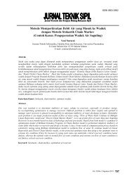
SITE DESCRIPTION<br />
Figure 1. IDF Curve with Van Breen Method<br />
The study plan site is at Jeruk Purut Area which is located in Kelurahan Cilandak<br />
Timur, Kecamatan Pasar Minggu, Kotamadya Jakarta Selatan. The existing rain catchment<br />
area is 70.233 ha with the majority land usage of residence and some part of the Jeruk Purut<br />
Cemetery (BPS, 2008). In this area, it is located the major drainage channel which collects the<br />
rainwater from Jeruk Purut minor channels that will be ended in Kali Krukut.<br />
<strong>PROBLEM</strong>S IDENTIFICATION<br />
Based on field observation, Jeruk Purut drainage system has some problem points that<br />
need to be reviewed. The locations which the problems in Jeruk Purut drainage system are<br />
occurred shown in Figure 2.<br />
Inadequate Channel Capacity (Location I)<br />
In some areas in the Jeruk Purut region, water overflow occurs flooding the road. The<br />
overflow that caused the water puddle is found in the complex area of Jl. Kenanga. According<br />
to the results of interviews with local residents, the water puddle is going up to ± 15 cm<br />
during rain and has the time of 10 minutes to recede. Channels in the flooded region are open<br />
minor channel and also passed through by Jeruk Purut major channel. Minor channels in the<br />
overflow area has a width of 50 cm and 50 cm depth, while the Jeruk Purut major channel<br />
which pass through this region has a width of 1.2 m and depth 1.2 m. The channels in this<br />
location accommodate the load that comes from the minor channels ± 600 m along Jl.<br />
Kenanga that have a majority of the land use is residential area. On the road that passed by the<br />
Jeruk Purut major channel in the complex Jl. Kenanga there is no minor channel on the other<br />
side of the road, it also supports the occurrence of water puddle problem on this road. This<br />
area topographically is the upstream area of the Water System in the Jeruk Purut, but the flood<br />
is still going when rain occurs. Of conditions that occur in that locations showed that the<br />
channel capacity in that location can not accommodate the rain water coming down in the<br />
area.<br />
WW5 - 5
Figure 2. Problems Location in Jeruk Purut Drainage System<br />
Garbage Pile in The Channel (Location II)<br />
Another thing that needs to be reviewed is also a heap of solid wastes cover the<br />
drainage channel. Channel that is filled with garbage found in the area Jl. Taman Jeruk Purut<br />
which is a minor channel that flows into the Jeruk Purut major channel. This channel is an<br />
open channel that accommodates the loads from some of the Jl. Pemerintahan complex. This<br />
channel have a width of 50 cm and depth of 50 cm. Waste piles that fill this channel have the<br />
height about 15 cm and the width as same as the channel so that the channel’s depth that<br />
passed by the flow is becoming about 35 cm. Those piles causes overflow at ± 20 cm to cover<br />
the entire road and have the receding time of 10 minutes, but the flooded road is a blind alley<br />
and not a main road.<br />
Sedimentation in The Channel (Location III)<br />
The channel that has the sedimentation is located at the minor channel in Jl. Taman<br />
Jeruk Purut. This channel has a width of 60 cm and the depth of 60 cm and it is an open<br />
channel. Sedimentation is caused by the mud that is in the channel. Those muds can be caused<br />
by the soil that is brought by the runoff to the channel or it can also be caused by the domestic<br />
waste that is dumped into the channel. In this case, the cause of the sedimentation is the soil<br />
brought by the runoff; it is proved by the location of the channel that is around the open field<br />
area. The existing sedimentation have the height about 15 cm and the width as same as the<br />
channel so that the channel’s depth that passed by the flow is becoming about 45 cm. This<br />
causes the channel capacity is reduced so that no longer can accommodate runoff flow which<br />
will cause water overflow. According to interviews with residents around this area, the puddle<br />
that happened was as high as 20 cm and has a 5-10 minutes receding time.<br />
Channel Constringency (Location IV)<br />
One of the problems that occurred in the drainage system of Jeruk Purut is there is<br />
channel constrigency. This constringency occurred on Jeruk Purut major channel that is<br />
WW5 - 6
located in Jl. Melati complex. That channel that previously have the width of 1.2 m and the<br />
depth of 1 m narrowed to 1 m in width and 1 m in depth due to the change of land usage<br />
around that location. This problem is quite an important problem because the load that flowed<br />
into this channel is coming from half of Jl. Jeruk Purut and the whole complex of Jl. Melati.<br />
The water puddle that occured is about 15 cm with the receding time of 10 minutes.<br />
Other problems<br />
One of the other problems that occur on some point on the Jeruk Purut drainage water<br />
system is them is a drainage channel closure by traders who sells at the top of the channel and<br />
building up a semi-permanent above the channel. This will increase the runoff that occurred<br />
on the road. The other problem is closed drainage channel by the home owner who enlarge<br />
their houses to the road but does not include the street Inlet, which caused rain water can not<br />
enter the channel is a channel that should be open.<br />
There is some point on the Jeruk Purut area that have this same problem, which is<br />
there is no drainage channel on the side road. This problem usually occurs on the streets or<br />
alleys, the narrow alleys that can not be passed by vehicles. This will cause the rain water runs<br />
on the road so that it will disrupt the mobility of local residents when it rains. Because of the<br />
problems, in some particular location, there are several non-technical channel is created by<br />
local people.<br />
<strong>PROBLEM</strong>S <strong>EVALUATION</strong><br />
In areas that have been identified and problematic, evaluation is performed to the<br />
identified problems by comparing the calculated discharge using the existing dimensions or<br />
capacity of the existing channel with the discharge calculated using the hydrological analysis<br />
results or the actual debit occurs. Existing channel capacity calculation is done using Manning<br />
equation (Eq. 1) with the assumption of a full flowing stream in an open channel, and<br />
discharge calculations based on the intensity of rain runoff from the Hydrology Analysis<br />
using Modified Rational Equation (Eq. 2).<br />
The results of the existing channel capacity calculations for all minor and major<br />
channels on the location of the I-IV are shown in Table 3, while the calculated runoff<br />
discharge in accordance with the intensity of the rain that happens to all minor and major<br />
channels on the location of the I-IV are shown in Table 4.<br />
Table 3. The calculation of the existing channel capacity on all channels at location I-IV<br />
Location Segment<br />
I<br />
Point<br />
Start End<br />
WW5 - 7<br />
Condition<br />
Existing<br />
Q (m 3 /s)<br />
48 C13 C14<br />
0.141<br />
49 C14 C15 0.183<br />
56<br />
57<br />
C22<br />
C23<br />
C23<br />
C24<br />
-<br />
0.279<br />
0.206<br />
59 C26 C27 0.243<br />
Mayor 8 M11 M12 3.011<br />
II 38 B11 B12<br />
III 149 I32 I33<br />
IV Mayor 5 M7 M8<br />
Without Garbage 0.379<br />
With Garbage 0.242<br />
Without Sediment 0.898<br />
With Sediment 0.628<br />
Before Constriction 3.383<br />
After Constriction 2.607
Table 4. The calculation of the actual discharge occured on all channels at Location I-IV<br />
Location Segment<br />
Point<br />
Start End<br />
WW5 - 8<br />
Runoff Q (m 3 /s)<br />
48 C13 C14 0.831<br />
49 C14 C15 0.926<br />
I<br />
56<br />
57<br />
C22<br />
C23<br />
C23<br />
C24<br />
0.601<br />
0.677<br />
59 C26 C27 0.800<br />
Mayor 8 M11 M12 5.625<br />
II 38 B11 B12 0.269<br />
III 149 I32 I33 0.855<br />
IV Mayor 5 M7 M8 3.335<br />
Inadequate Channel Capacity (Location I)<br />
From the results of calculations on the location I, it is obtained that some channel<br />
segments in this region aree no longer can accommodate the rain water. These segments of<br />
the major channels (M11 - M12) and several minor channel segments (C13 - C15 and C22 -<br />
C27). For minor and major channels in the location I, the value of Manning coefficient (n)<br />
used in the Manning equation is of 0.014 (for the ordinary concrete channels, steel mold good<br />
condition).<br />
In the calculation of runoff discharge in minor and major channels in the location I the<br />
conversion factor used is 1/360 (Q in m 3 /s) and storage coefficient value (Cs) is 1 because it is<br />
assumed there are no storation occured in the channels because of the dense residential and<br />
the channel length is not too long. As for the value of rain intensity in the calculation of the<br />
minor channel is 76.83 mm/h at time concentrations of 120 minutes and 5 Years Recurrence<br />
Interval, and the calculation of the major channel is 82.9 mm/h at time concentrations of 120<br />
minutes and 5 Years Recurrence Interval.<br />
The results of calculations on the location I suggest that minor and major channels that<br />
have been identified and the problem was no longer able to stream flow runoff occurs. This<br />
may occur because of changes in land use in catchment areas such channels. Based on field<br />
observations, catchment area for these channels are coming from a fairly dense residential.<br />
Overflow discharge that occurs in the channels in location I shown in Table 5.<br />
Table 5. Comparison between the existing discharge and runoff discharge for Location I<br />
Segment Existing Q (m 3 /s) Runoff Q (m 3 /s) Q Difference (m 3 /s)<br />
C13 - C15 0.141 0.831 0.690<br />
C14 - C15 0.183 0.926 0.742<br />
C22 - C23 0.279 0.601 0.321<br />
C23 - C24 0.206 0.677 0.471<br />
C26 - C27 0.243 0.800 0.556<br />
M11 - M12 3.011 5.625 2.613<br />
Garbage Pile in The Channel (Location II)<br />
For channels in the location II, the value of Manning coefficient (n) used in the<br />
Manning equation is of 0.014 (for the ordinary concrete channels, steel mold good condition).<br />
In the calculation of runoff discharge in the channel at location II the conversion factor used is<br />
1/360 (Q in m 3 /s) and storage coefficient value (Cs) is 1 because it is assumed there are no<br />
storation occured in the channels because of the dense residential and the channel length is not
too long. As for the value of rain intensity in the calculation of the minor channel is 76.83<br />
mm/h at time concentrations of 120 minutes and 5 Years Recurrence Interval.<br />
The results of calculations on the location of II show that the presence of the waste in<br />
the channel causes a change in the existing capacity of the channel. This can occur because of<br />
the reduced depth of the channel due to the garbage pile. The reduced depth of the channel<br />
will reduce the cross-sectional area through which flow so that the channel capacity will be<br />
reduced. The overflow discharge is 0.027 m 3 /s at location II. Calculation comparison between<br />
the existing discharge with the runoff discharge at location II shown in Table 6.<br />
Table 6. Comparison between the existing discharge and runoff discharge for Location II<br />
Condition Existing Q (m 3 /s) Runoff Q (m 3 /s) Q Difference (m 3 /s)<br />
Without Garbage 0.379<br />
-0.109<br />
0.269<br />
With Garbage 0.242 0.027<br />
Sedimentation in The Channel (Location III)<br />
For channels in the location III, the value of Manning coefficient (n) used in the<br />
Manning equation is of 0.014 (for the ordinary concrete channels, steel mold good condition).<br />
In the calculation of runoff discharge in the channel at location II the conversion factor used is<br />
1/360 (Q in m 3 /s) and storage coefficient value (Cs) is 1 because it is assumed there are no<br />
storation occured in the channels because of the dense residential and the channel length is not<br />
too long. As for the value of rain intensity in the calculation of the minor channel is 76.83<br />
mm/h at time concentrations of 120 minutes and 5 Years Recurrence Interval.<br />
The results of calculations on the location of III show that the presence of the<br />
sedimentation in the channel causes a change in the existing capacity of the channel. This can<br />
occur because of the reduced depth of the channel due to the sedimentation. The reduced<br />
depth of the channel will reduce the cross-sectional area through which flow so that the<br />
channel capacity will be reduced. The overflow discharge is 0.227 m 3 /s at location III.<br />
Calculation comparison between the existing discharge with the runoff discharge at location<br />
III shown in Table 7.<br />
Table 7. Comparison between the existing discharge and runoff discharge for Location III<br />
Condition Existing Q (m 3 /s) Runoff Q (m 3 /s) Q Difference (m 3 /s)<br />
Without Sedimentation 0.898<br />
-0.043<br />
0.855<br />
With Sedimentation 0.628 0.227<br />
Channel Constringency (Location IV)<br />
For channels in the location IV, the value of Manning coefficient (n) used in the<br />
Manning equation is of 0.014 (for the ordinary concrete channels, steel mold good condition).<br />
In the calculation of runoff discharge in the channel at location IV the conversion factor used<br />
is 1/360 (Q in m 3 /s) and storage coefficient value (Cs) is 1 because it is assumed there are no<br />
storation occured in the channels because of the dense residential and the channel length is not<br />
too long. As for the value of rain intensity in the calculation of the minor channel is 82.9<br />
mm/h at time concentrations of 120 minutes and 5 Years Recurrence Interval.<br />
The results of calculations on the location of IV show that the constriction causes a<br />
change in the existing capacity of the channel. This can occur because of the reduced width of<br />
WW5 - 9
the channel due to narrowing of the channel. The reduced width of the channel will reduce the<br />
cross-sectional area through which flow so that the channel capacity will be reduced. From<br />
the results of calculations on the problem of debit differences in location IV shows that before<br />
the constrigency channel capacity can still accommodate runoff flow, while the constriction<br />
occurs the capacity of in the channel is not enough to stream flow runoff. The overflow<br />
discharge is 0.728 m 3 /s. Calculation comparison between the existing discharge with the<br />
runoff discharge at location IV shown in Table 8.<br />
Table 8. Comparison between the existing discharge and runoff discharge for Location IV<br />
CONCLUSION<br />
Condition<br />
Existing Q<br />
(m 3 /s)<br />
Runoff Q (m 3 /s)<br />
Q Difference<br />
(m 3 /s)<br />
Before Constringency<br />
After Constringency<br />
3.383<br />
2.607<br />
3.335<br />
-0.048<br />
0.728<br />
Based on field surveys and taking primary and secondary data can be identified that<br />
Jeruk Purut drainage system has several problems which need to be reviewed. These problems<br />
include channel capacity at some locations can not accommodate the rain water that caused<br />
overflow, garbage piles that filled the drainage channel leading to a surge of up to cover the<br />
entire section, sedimentation due to mud in the drainage channel, drainage channel narrowing<br />
due to change in order to land around the channel. Evaluation results show that the problems<br />
are the cause of the difference between the runoff discharge that occurs and the existing<br />
discharge, so the channel is no longer enough rain water drains on the current conditions.<br />
REFERENCES<br />
Abdeldayem. S, 2005, Agricultural Drainage : Towards an Integrated Approach,<br />
Irrigation and Drainage Systems, 19:71-87<br />
Amini. A, 2009, Adjustment of Peak Streamflows of a Tropcial River for Urbanization,<br />
American Journal of Environmental Sciences 5, 3:285-294<br />
BPS. 2008. Jakarta Selatan Dalam Angka, Jakarta : BPS Kotamadya Jakarta Selatan.<br />
Hardjosuprapto. Masduki, 1998. Drainase Perkotaan Volume 1, Bandung: Penerbit<br />
<strong>ITB</strong><br />
Inbar. M, 2002, A Geeomorphic and Environmental Evaluation of the Hula Drainage<br />
Project, Israel, Australian Geographical Studies, 40:155-166<br />
Long. A.R , 2007, Drainage Evaluation at the U.S. 50 Joint Sealant Experiment,<br />
Journal of Transportation Engineering, 133<br />
Lo Russo. S, 2009, Groundwater in the Urban Environment: Management Needs and<br />
Planning Strategies, American Journal of Environmental Sciences 5, 3:493-499<br />
Suripin. 2004. Sistem Drainase Perkotaan yang Berkelanjutan. Yogyakarta: ANDI<br />
Yogyakarta<br />
WW5 - 10