

Jerilderie Nature Reserve - Department of Environment and Climate ...
Jerilderie Nature Reserve - Department of Environment and Climate ...
Jerilderie Nature Reserve - Department of Environment and Climate ...

You also want an ePaper? Increase the reach of your titles
YUMPU automatically turns print PDFs into web optimized ePapers that Google loves.
<strong>Jerilderie</strong><br />
<strong>Nature</strong> <strong>Reserve</strong><br />
Plan <strong>of</strong> Management
JERILDERIE NATURE RESERVE<br />
PLAN OF MANAGEMENT<br />
NSW National Parks <strong>and</strong> Wildlife Service<br />
Part <strong>of</strong> the <strong>Department</strong> <strong>of</strong> <strong>Environment</strong>, <strong>Climate</strong> Change <strong>and</strong> Water<br />
May 2010
This plan <strong>of</strong> management was adopted by the Minister for <strong>Climate</strong> Change <strong>and</strong><br />
the <strong>Environment</strong> on 18 th May 2010.<br />
For additional information or enquiries on <strong>Jerilderie</strong> <strong>Nature</strong> <strong>Reserve</strong> or this plan, contact<br />
the NPWS Western Rivers Region, Griffith Area <strong>of</strong>fice at 200 Yambil Street Griffith, or<br />
by phone on (02) 6966 8100.<br />
© <strong>Department</strong> <strong>of</strong> <strong>Environment</strong>, <strong>Climate</strong> Change <strong>and</strong> Water (NSW) 2010: Use<br />
permitted with appropriate acknowledgment.<br />
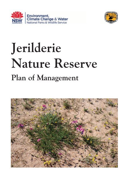
Cover photograph <strong>of</strong> the threatened Red Darling Pea (Swainsona plagiotropis) in<br />
<strong>Jerilderie</strong> <strong>Nature</strong> <strong>Reserve</strong> by Colin Killick, NPWS.<br />
ISBN 978 1 74232 800 3<br />
DECCW 2010/493
FOREWORD<br />
<strong>Jerilderie</strong> <strong>Nature</strong> <strong>Reserve</strong> covers an area <strong>of</strong> 36.92 hectares <strong>and</strong> is located 500 metres<br />
west <strong>of</strong> the township <strong>of</strong> <strong>Jerilderie</strong> in the NSW Riverina.<br />
<strong>Jerilderie</strong> <strong>Nature</strong> <strong>Reserve</strong> contains a rare grassl<strong>and</strong> vegetation community <strong>and</strong> at least<br />
three threatened plants. It was established in 2002 to protect the nationally endangered<br />
plant red Swainson pea (also known as the red Darling pea). It also conserves other<br />
grassl<strong>and</strong> species.<br />
The New South Wales National Parks <strong>and</strong> Wildlife Act 1974 requires that a plan <strong>of</strong><br />
management be prepared for each nature reserve. A plan <strong>of</strong> management is a legal<br />
document that outlines how an area will be managed in the years ahead.<br />
A draft plan <strong>of</strong> management for <strong>Jerilderie</strong> <strong>Nature</strong> <strong>Reserve</strong> was placed on public<br />
exhibition from 29 th August until 1 st December 2008. The submissions received were<br />
carefully considered before adopting this plan.<br />
The plan contains actions to achieve the State Plan priority to “Protect our native<br />
vegetation, biodiversity, l<strong>and</strong>, rivers <strong>and</strong> coastal waterways”, including maintaining the<br />
reserve free <strong>of</strong> introduced plants <strong>and</strong> animals to conserve the threatened grassl<strong>and</strong><br />
species.<br />
This plan <strong>of</strong> management establishes the scheme <strong>of</strong> operations for <strong>Jerilderie</strong> <strong>Nature</strong><br />
<strong>Reserve</strong>. In accordance with Section 73B <strong>of</strong> the National Parks <strong>and</strong> Wildlife Act 1974,<br />
this plan <strong>of</strong> management is hereby adopted.<br />
Frank Sartor MP<br />
Minister for <strong>Climate</strong> Change <strong>and</strong> the <strong>Environment</strong>
CONTENTS<br />
1. LOCATION, GAZETTAL AND REGIONAL SETTING 1<br />
2. MANAGEMENT CONTEXT 1<br />
2.1 LEGISLATIVE AND POLICY FRAMEWORK 1<br />
2.2 MANAGEMENT PURPOSES AND PRINCIPLES 3<br />
2.3 MANAGEMENT OBJECTIVES 3<br />
3. JERILDERIE NATURE RESERVE 4<br />
3.1 NATURAL VALUES 4<br />
3.2 CULTURAL VALUES 6<br />
3.3 USE OF AREA 6<br />
4. IMPLEMENTATION TABLE 7<br />
5. REFERENCES 11<br />
FIGURE 1: LOCATION OF JERILDERIE NATURE RESERVE 2<br />
APPENDIX 1: PLANT LIST 12
1 LOCATION, GAZETTAL AND REGIONAL SETTING<br />
<strong>Jerilderie</strong> <strong>Nature</strong> <strong>Reserve</strong> covers an area <strong>of</strong> 36.92 hectares <strong>and</strong> is located 500 metres<br />
west <strong>of</strong> <strong>Jerilderie</strong> township, <strong>of</strong>f the Conargo Road (see map, page 2). It was established<br />
to protect the nationally endangered plant red Swainson pea (also known as red Darling<br />
pea) Swainsona plagiotropus.<br />
In September 1991 the NSW National Parks <strong>and</strong> Wildlife Service (NPWS) employed a<br />
consultant to prepare a recovery plan for red Swainson pea. Twenty two sites<br />
containing the plant were discovered around <strong>Jerilderie</strong>, a town <strong>of</strong> 900 people which is<br />
located in the Riverina. The location is considered one <strong>of</strong> the key grassl<strong>and</strong> sites in the<br />
Riverina (Benson et al 1997).<br />
During the development <strong>of</strong> <strong>Jerilderie</strong> Shire Council’s Draft Local <strong>Environment</strong> Plan,<br />
Council was informed <strong>of</strong> the presence <strong>of</strong> red Swainson pea on a 60 hectare block <strong>of</strong><br />
l<strong>and</strong> purchased by Council which was intended for subdivision into 2 hectare blocks.<br />
A large part <strong>of</strong> this block (Lot 431, DP 1013379 <strong>of</strong> County Urana, Parish <strong>Jerilderie</strong><br />
South) was subsequently purchased by NPWS <strong>and</strong> gazetted as <strong>Jerilderie</strong> <strong>Nature</strong><br />
<strong>Reserve</strong> on 24 April 2002.<br />
Immediately surrounding <strong>Jerilderie</strong> <strong>Nature</strong> <strong>Reserve</strong> are open paddocks, with some light<br />
industrial structures nearby. <strong>Jerilderie</strong> township is in close proximity, about half a<br />
kilometre to the east. It is within the geographical area <strong>of</strong> the Murray Catchment<br />
Management Authority <strong>and</strong> Cummeragunja Local Aboriginal L<strong>and</strong> Council.<br />
2.1 LEGISLATIVE AND POLICY FRAMEWORK<br />
2 MANAGEMENT CONTEXT<br />
<strong>Jerilderie</strong> <strong>Nature</strong> <strong>Reserve</strong> is managed under a legislative <strong>and</strong> policy framework primarily<br />
the National Parks <strong>and</strong> Wildlife Act 1974 (NPW Act), the National Parks <strong>and</strong> Wildlife<br />
Regulation, the Threatened Species Conservation Act 1995 (TSC Act) <strong>and</strong> the policies<br />
<strong>of</strong> the National Parks <strong>and</strong> Wildlife Service (NPWS). Section 72A <strong>of</strong> the NPW Act lists<br />
the matters to be considered in the preparation <strong>of</strong> a plan <strong>of</strong> management. The policies<br />
arise from the legislative background <strong>and</strong> internationally accepted principles <strong>of</strong> park<br />
management. They relate to nature conservation, Aboriginal <strong>and</strong> historic heritage<br />
conservation, recreation, commercial use, research <strong>and</strong> communication.<br />
Other legislation, international agreements <strong>and</strong> charters may also apply to management<br />
<strong>of</strong> the area. In particular, the <strong>Environment</strong>al Planning <strong>and</strong> Assessment Act 1979 may<br />
require the assessment <strong>and</strong> mitigation <strong>of</strong> the environmental impacts <strong>of</strong> works proposed<br />
in this plan. The Commonwealth <strong>Environment</strong> Protection <strong>and</strong> Biodiversity Conservation<br />
Act 1999 also applies in relation to actions that may impact on those threatened<br />
species listed under that Act.<br />
A plan <strong>of</strong> management is a statutory document under the NPW Act. Once the Minister<br />
has adopted a plan, no operations may be undertaken within <strong>Jerilderie</strong> <strong>Nature</strong> <strong>Reserve</strong><br />
except in accordance with the plan. This plan will also apply to any future additions to<br />
<strong>Jerilderie</strong> <strong>Nature</strong> <strong>Reserve</strong>. Where management strategies or works are proposed for<br />
the nature reserve or any additions that are not consistent with the plan, an amendment<br />
to the plan will be required.<br />
1
FIGURE 1: LOCATION OF JERILDERIE NATURE RESERVE
2.2 MANAGEMENT PURPOSES AND PRINCIPLES<br />
<strong>Nature</strong> reserves are reserved under the NPW Act to protect <strong>and</strong> conserve areas<br />
containing outst<strong>and</strong>ing, unique or representative ecosystems, species, communities or<br />
natural phenomena.<br />
Under the Act, nature reserves are managed to:<br />
• conserve biodiversity, maintain ecosystem functions, <strong>and</strong> protect geological <strong>and</strong><br />
geomorphological features <strong>and</strong> natural phenomena;<br />
• conserve places, objects, features <strong>and</strong> l<strong>and</strong>scapes <strong>of</strong> cultural value;<br />
• promote public appreciation, enjoyment <strong>and</strong> underst<strong>and</strong>ing <strong>of</strong> the reserve’s natural<br />
<strong>and</strong> cultural values; <strong>and</strong><br />
• provide for appropriate research <strong>and</strong> monitoring.<br />
<strong>Nature</strong> reserves differ from national parks in that they do not have as a management<br />
principle the provision <strong>of</strong> opportunities for visitor use.<br />
2.3 MANAGEMENT OBJECTIVES<br />
The primary objective in managing <strong>Jerilderie</strong> <strong>Nature</strong> <strong>Reserve</strong> will be to conserve <strong>and</strong>, if<br />
possible, exp<strong>and</strong> the population <strong>of</strong> red Swainson pea present on the reserve.<br />
A secondary objective will be to conserve the other threatened plants present, including<br />
turnip copperburr Sclerolaena napiformis <strong>and</strong> Murray Swainson pea (also known as<br />
slender Darling pea) Swainsona murrayana, as well as the other grassl<strong>and</strong> species.<br />
3
3.1 NATURAL VALUES<br />
L<strong>and</strong>form, Geology <strong>and</strong> Soils<br />
3 JERILDERIE NATURE RESERVE<br />
The terrain is part <strong>of</strong> the Murray Basin <strong>and</strong> is a level plain comprised <strong>of</strong> a light<br />
brown/red soil <strong>and</strong> clay loam. The only notable feature is a dam that was constructed in<br />
the centre <strong>of</strong> the reserve prior to acquisition. The dam retains water after rain, but dries<br />
out quickly in hot weather. There are no watercourses, roads or management trails in<br />
the reserve.<br />
Native Plants<br />
The reserve contains a diverse sample <strong>of</strong> Riverine Enteropogon-Stipa grassl<strong>and</strong>. This<br />
community occurred extensively on the South-Western Plains prior to European<br />
settlement. Remnant patches are now rare (Benson et al. 1997). The community has<br />
been nominated for listing as endangered under the Commonwealth <strong>Environment</strong><br />
Protection <strong>and</strong> Biodiversity Conservation Act 1999.<br />
The <strong>Jerilderie</strong> <strong>Nature</strong> <strong>Reserve</strong> grassl<strong>and</strong> includes three nationally threatened species:<br />
turnip copperburr Sclerolaena napiformis; red Swainson-pea (also known as red Darling<br />
pea) Swainsona plagiotropis; <strong>and</strong> Murray Swainson-pea (also known as slender Darling<br />
pea), Swainsona murrayana.<br />
The reserve is one <strong>of</strong> only 22 confirmed red Swainson pea sites in NSW, all <strong>of</strong> which<br />
are found in the <strong>Jerilderie</strong>-Urana area. In 1991 surveys by McDougall, Appleby <strong>and</strong><br />
Barlow (2003) recorded 20,000 plants <strong>of</strong> S. plagiotropis in the vicinity <strong>of</strong> what was to<br />
become the nature reserve. Prior to their work the entire national population had been<br />
estimated at just 2,000 plants. The <strong>Jerilderie</strong> area is now recognised as the stronghold<br />
<strong>of</strong> the species, containing 80% <strong>of</strong> the total known population <strong>of</strong> the species.<br />
Turnip copperburr is a saltbush that is listed as endangered under the NSW<br />
Threatened Species Conservation Act 1995, while both red Swainson-pea <strong>and</strong> Murray<br />
Swainson-pea are listed as vulnerable under the NSW Threatened Species<br />
Conservation Act 1995 as well as the Commonwealth <strong>Environment</strong> Protection <strong>and</strong><br />
Biodiversity Conservation Act 1999.<br />
Swainsona species are small plants which can resprout from a persistent rootstock. By<br />
this means they can survive long dry periods lasting a number <strong>of</strong> years before suitable<br />
conditions return. Growth <strong>and</strong> flowering are stimulated by moisture.<br />
Other significant species in the reserve include yellow-tongued daisy Brachycome<br />
chrysoglossa; long eryngium Eryngium plantagineum; woolly buttons Leptorhychos<br />
panaetiodes; bottle fissue-weed Maireana excavata; <strong>and</strong> yam daisy or murnong<br />
Microseris lanceolata. All <strong>of</strong> these are indicators <strong>of</strong> good quality grassl<strong>and</strong> (Scarlett et.<br />
al. 1992). There are also at least three regenerating boree trees (Acacia pendula) in<br />
the reserve <strong>and</strong> two in the paddock outside the reserve to the north. This could mean<br />
that the area was once a Myall grassy woodl<strong>and</strong>, which is now an endangered<br />
ecological community.<br />
4
Swainsona species <strong>and</strong> other forbs prefer grassl<strong>and</strong> maintained in a fairly open<br />
condition. Heavy growth <strong>of</strong> grass over a number <strong>of</strong> years may suppress those species<br />
<strong>and</strong> jeopardise their viability. In drought years, lack <strong>of</strong> moisture may assist in keeping<br />
the grassl<strong>and</strong> open. However, dense growth following periods <strong>of</strong> rain may require more<br />
active management. Ideally, biomass should not exceed 5–7 tonnes per hectare (J.<br />
Briggs, Dept. <strong>of</strong> <strong>Environment</strong> <strong>and</strong> <strong>Climate</strong> Change, pers. comm. 2008). Options that<br />
could be considered to reduce excessive biomass are burning, grazing <strong>and</strong>/or slashing.<br />
Burning has the advantage <strong>of</strong> not only reducing biomass, but also assisting with<br />
Swainsona seed germination. However, fire can be difficult to control in grassl<strong>and</strong> <strong>and</strong><br />
the presence <strong>of</strong> <strong>Jerilderie</strong> town nearby, including a hospital in close proximity to the<br />
reserve, would require this option be exercised with care. Controlled burning should be<br />
at irregular intervals <strong>and</strong> over patches <strong>of</strong> the reserve only (J. Benson, Dept. <strong>of</strong><br />
<strong>Environment</strong> <strong>and</strong> <strong>Climate</strong> Change, pers. comm. 2008). The reserve should be<br />
protected from unscheduled burning.<br />
Although not generally permitted in a nature reserve, occasional grazing by sheep to<br />
maintain an open structure was considered. However, this is not a preferred option<br />
since although there is a dam in the reserve it is not a reliable water source as it dries<br />
out quickly; grazing would need to be light <strong>and</strong> intermittent, not continuous, <strong>and</strong> should<br />
not occur in the spring (J. Benson pers. comm.); <strong>and</strong> the Priorities Action Statement<br />
advises against grazing during wet periods to avoid plugging <strong>and</strong> soil disturbance<br />
(www.threatenedspecies.environment.nsw.gov.au/tspr<strong>of</strong>ile).<br />
Slashing would create mulch that would have to be removed or it would choke smaller<br />
native species. This is not a practical option.<br />
Permanent monitoring plots are required to gather data about the response <strong>of</strong><br />
Swainsona <strong>and</strong> the grass cover to management activities <strong>and</strong> external influences, such<br />
as climate.<br />
A full list <strong>of</strong> the flora <strong>of</strong> <strong>Jerilderie</strong> <strong>Nature</strong> <strong>Reserve</strong> is in the Appendix to this plan.<br />
Native Animals<br />
Fourteen fauna species (13 birds <strong>and</strong> 1 frog) have been recorded on the reserve,<br />
although very limited surveys have been undertaken. Species recorded are typical <strong>of</strong><br />
open habitats, such as brown songlarks Cinclorhamphus cruralis, pipits Anthus<br />
novaeseel<strong>and</strong>iae <strong>and</strong> kestrels Falco cenchroides, or associated with the dam (wood<br />
ducks Chenonetta jubata <strong>and</strong> eastern sign-bearing froglets Crinia parinsignifera).<br />
Small mammals <strong>and</strong> reptiles typical <strong>of</strong> grassl<strong>and</strong> habitats, such as the fat-tailed dunnart<br />
Sminthopsis crassicaudata <strong>and</strong> the hooded scaly-foot Pygopus schraderi, could be<br />
expected to occur on the reserve. Macropods, such as Eastern grey kangaroos<br />
Macropus giganteous, occasionally pass through the reserve. No threatened animal<br />
species have been recorded to date in the reserve.<br />
5
3.2 CULTURAL VALUES<br />
Aboriginal Heritage<br />
<strong>Jerilderie</strong> <strong>Nature</strong> <strong>Reserve</strong> lies within the traditional country <strong>of</strong> the Wiradjuri people <strong>and</strong><br />
is within the boundaries <strong>of</strong> the Cummeragunja Local Aboriginal L<strong>and</strong> Council. The<br />
reserve is not currently known to have particular Aboriginal cultural values <strong>and</strong> no<br />
evidence <strong>of</strong> the Aboriginal significance or <strong>of</strong> Aboriginal occupation or activity has been<br />
found there.<br />
Historic Heritage<br />
The nature reserve is part <strong>of</strong> a portion <strong>of</strong> 60 hectares <strong>of</strong> l<strong>and</strong> purchased by <strong>Jerilderie</strong><br />
Shire Council in 1991 for the purpose <strong>of</strong> sub-division <strong>and</strong> development. A portion <strong>of</strong> the<br />
l<strong>and</strong> was later purchased by NPWS <strong>and</strong> became a nature reserve in 2002.<br />
There are no structures on the l<strong>and</strong> other than a 3,000 cubic metre dam (ground tank),<br />
boundary fencing <strong>and</strong> two exclosures built by <strong>Jerilderie</strong> Shire before acquisition by<br />
NPWS, one in the north-east corner <strong>and</strong> one on the eastern boundary.<br />
Given the excellent condition <strong>of</strong> the grassl<strong>and</strong> it is unlikely that the l<strong>and</strong> was used for<br />
any purpose other than grazing prior to purchase by the Council.<br />
There are no sites <strong>of</strong> historic heritage in the reserve.<br />
3.3 USE OF THE AREA<br />
There is minimal recreational use <strong>of</strong> the reserve as it occurs as an empty paddock<br />
within a l<strong>and</strong>scape <strong>of</strong> paddocks, <strong>and</strong> no increase in use is intended or expected in the<br />
future. There are no walking tracks or management trails in the reserve. General<br />
interpretation <strong>of</strong> the significance <strong>of</strong> the reserve to grassl<strong>and</strong> conservation is appropriate.<br />
However, providing interpretation that specifically identifies threatened plants should be<br />
avoided as this runs the risk <strong>of</strong> drawing unwelcome attention to them. This could result<br />
in the plants being trampled by curious visitors or even targeted by pickers <strong>and</strong> v<strong>and</strong>als.<br />
Therefore public access to the reserve will not be encouraged <strong>and</strong> no walking tracks will<br />
be provided. Any interpretation <strong>of</strong> the grassl<strong>and</strong> should be placed at the boundary <strong>of</strong><br />
the reserve, so that it can be read without entering the reserve.<br />
6
4. IMPLEMENTATION TABLE<br />
Current Situation Desired Outcomes Strategies Priority<br />
Soil <strong>and</strong> Water Conservation<br />
There is no unnatural erosion in the reserve.<br />
A large dam is located in the centre <strong>of</strong> the<br />
reserve. The dam is not creating any<br />
management issues <strong>and</strong> it may be useful for<br />
fire fighting.<br />
Native Plant <strong>and</strong> Animal Conservation<br />
The reserve contains a rare grassl<strong>and</strong><br />
vegetation community <strong>and</strong> at least three<br />
threatened plants.<br />
Red Darling pea <strong>and</strong> Murray Swainson pea<br />
<strong>and</strong> other forbs prefer grassl<strong>and</strong> vegetation<br />
maintained in a fairly open state. Turnip<br />
copperburr also prefers grassl<strong>and</strong> areas.<br />
A number <strong>of</strong> Swainsona monitoring sites have<br />
been established.<br />
Maintenance <strong>of</strong> the native grassl<strong>and</strong> will<br />
provide habitat for those animals dependent<br />
on this vegetation community.<br />
The reserve remains free <strong>of</strong><br />
unnatural erosion.<br />
The dam is retained.<br />
The population <strong>of</strong> Red Darling<br />
pea is at least maintained <strong>and</strong>, if<br />
possible, increased.<br />
The native grassl<strong>and</strong> will be<br />
maintained in good condition.<br />
7<br />
• The reserve will be monitored for<br />
unnatural erosion <strong>and</strong> remedial action<br />
taken where necessary.<br />
• No action will be taken to damage the<br />
dam. However, the dam will not be<br />
actively maintained unless it is later<br />
found to be required for management<br />
purposes, such as fire fighting.<br />
• Broad scale herbicide will not be used<br />
in the reserve.<br />
• Mechanical soil disturbance will not be<br />
undertaken in the reserve.<br />
• Quadrats <strong>and</strong> photo points at existing<br />
monitoring sites will be monitored<br />
annually to check Swainsona numbers<br />
<strong>and</strong> the condition <strong>of</strong> the grassl<strong>and</strong> <strong>and</strong><br />
records maintained.<br />
• Fire may be used as a management<br />
tool to encourage healthy grassl<strong>and</strong>.<br />
High<br />
High<br />
High<br />
High<br />
High<br />
High
Current Situation Desired Outcomes Strategies Priority<br />
Introduced Species<br />
No introduced vertebrate pest species are<br />
known to exist in the reserve.<br />
The grassl<strong>and</strong> is in good condition with<br />
relatively few introduced plants. No noxious<br />
weeds occur in the reserve.<br />
Cultural Heritage<br />
There is no evidence <strong>of</strong> either European or<br />
Aboriginal cultural heritage on the reserve.<br />
The reserve remains free <strong>of</strong><br />
vertebrate pests.<br />
The reserve remains free <strong>of</strong><br />
noxious weeds.<br />
Any items <strong>of</strong> cultural heritage<br />
located on the reserve will be<br />
protected.<br />
8<br />
• Vertebrate pests will be excluded<br />
where possible from <strong>and</strong> eliminated if<br />
found in the reserve in accordance with<br />
the Regional Pest Management<br />
Strategy.<br />
• Any noxious weeds will be treated in<br />
accordance with the Regional Pest<br />
Management Strategy. Control<br />
measures will be put in place to ensure<br />
no impact on endangered plants.<br />
• The Cummeragunja Local Aboriginal<br />
L<strong>and</strong> Council will be consulted prior to<br />
undertaking any works that could affect<br />
potential Aboriginal sites.<br />
High<br />
High<br />
High
Current Situation Desired Outcomes Strategies Priority<br />
Fire Management<br />
Fire may be a useful management tool to<br />
maintain the health <strong>of</strong> the grassl<strong>and</strong>, reduce<br />
biomass <strong>and</strong> encourage the growth <strong>of</strong><br />
Swainsona.<br />
Controlled burning is not required for asset<br />
protection purposes.<br />
Management Operations<br />
Management facilities consist <strong>of</strong> fences.<br />
These are in good order.<br />
There are no management trails in the<br />
reserve.<br />
Healthy grassl<strong>and</strong> <strong>and</strong> increased<br />
numbers <strong>of</strong> Swainsona.<br />
Life, property <strong>and</strong> natural <strong>and</strong><br />
cultural values are protected from<br />
wildfire<br />
Fences are maintained in good<br />
condition to exclude livestock.<br />
No trails will be constructed<br />
9<br />
• Burning to reduce biomass may be<br />
used where biomass exceeds 5–7<br />
tonnes per hectare.<br />
• No more than 25% <strong>of</strong> the reserve will<br />
be burnt in any calendar year.<br />
• The response <strong>of</strong> Swainsona to a<br />
burning event will be monitored <strong>and</strong><br />
assessed before any further burning is<br />
conducted.<br />
• Wildfires will be contained <strong>and</strong><br />
suppressed in conjunction with<br />
neighbours <strong>and</strong> fire authorities.<br />
• The fences will be inspected at least<br />
annually <strong>and</strong> maintained in good order.<br />
• Vehicular access to the reserve will be<br />
permitted for essential authorised<br />
management purposes only.<br />
High<br />
High<br />
High<br />
High<br />
High<br />
High
Current Situation Desired Outcomes Strategies Priority<br />
Visitor Use<br />
Visitation to the reserve is minimal. There are<br />
no walking tracks in the reserve.<br />
There are no visitor facilities <strong>and</strong> no<br />
interpretation provided on the reserve.<br />
Interpretive signs about grassl<strong>and</strong><br />
conservation may be provided in future.<br />
<strong>Reserve</strong> identification signs are provided on<br />
the boundaries<br />
Key to priorities<br />
Visitors will not be encouraged to<br />
enter the reserve.<br />
No structures are erected on the<br />
reserve other than signs.<br />
10<br />
• <strong>Reserve</strong> identification signs will be<br />
maintained.<br />
• Walking tracks will not be constructed.<br />
• Public entry on foot for low-impact<br />
walking is permitted<br />
• Public use <strong>of</strong> the reserve will not be<br />
promoted.<br />
• Bicycles <strong>and</strong> jogging are not permitted.<br />
• Buildings, temporary structures such<br />
as marquees/tents, <strong>and</strong> barbeques will<br />
not be permitted on the reserve.<br />
• Any on-site interpretation provided will<br />
be located so that visitors do not have<br />
to enter the reserve to read it <strong>and</strong> will<br />
be <strong>of</strong> a general nature, not specifically<br />
identify plants present in the reserve.<br />
High priority activities are those imperative to achievement <strong>of</strong> the objectives <strong>and</strong> desired outcomes. They must be undertaken in the<br />
near future to avoid significant deterioration in natural, cultural or management resources.<br />
Medium priority activities are those that are necessary to achieve the objectives <strong>and</strong> desired outcomes but are not urgent.<br />
Low priority activities are desirable to achieve management objectives <strong>and</strong> desired outcomes but can wait until resources become<br />
available.<br />
High<br />
High<br />
Low<br />
High<br />
High<br />
High<br />
High
5 REFERENCES<br />
Barlow, T.Y., 1998. ‘Grassy Guidelines: How to manage native grassl<strong>and</strong>s <strong>and</strong> grassy<br />
woodl<strong>and</strong>s on your property.’ Trust for <strong>Nature</strong>, Victoria.<br />
Benson, J.S., Ashby, E.M. <strong>and</strong> Porteners, M.F. ‘Native Grassl<strong>and</strong> <strong>of</strong> the Riverine Plain, New<br />
South Wales.’ Cunninghamia 5(1) 1-48.<br />
Brickhill, J., 1994. ‘Swainsona plagiotropis: New Area Proposal.’ Unpublished NPWS report.<br />
Crawford, I., 1993. ‘Report on five sites carrying Red Swainson-pea, Swainsona plagiotropis,<br />
at <strong>Jerilderie</strong>, NSW, <strong>and</strong> recommendations on the propagation <strong>and</strong> management <strong>of</strong> the<br />
species.’ Unpublished report prepared for <strong>Jerilderie</strong> Shire Council.<br />
Earl, G., Barlow, T. & Moorees, A., 2003. ‘Twelve Threatened Swainson-peas <strong>and</strong> Darling-peas<br />
(Swainsona species)’. Action Statement No. 126. Flora & Fauna Guarantee Act 1988.<br />
Victoria.<br />
Foreman, P., 1994. ‘A recovery plan (research phase) for Swainsona plagiotropis in NSW.’<br />
Unpublished report for NSW NPWS funded by the Australian <strong>Nature</strong> Conservation<br />
Agency.<br />
McDougall, K., Appleby, M. & Barlow, T., 1991. ‘Populations <strong>of</strong> Swainsona plagiotropis in<br />
Victoria <strong>and</strong> New South Wales. A summary <strong>of</strong> surveys conducted for NSW NPWS <strong>and</strong><br />
World Wide Fund for <strong>Nature</strong>’. Unpublished report by Habitat Works, Brunswick,<br />
Melbourne.<br />
Scarlett, N.H., Wallbrink, S.J., McDougall, K., 1992. ‘Field Guide to Victoria’s Native<br />
Grassl<strong>and</strong>.’ Victoria Press, South Melbourne.<br />
11
APPENDIX: PLANT LIST<br />
Acacia pendula Boree<br />
Alternanthera denticulate Lesser Joyweed<br />
Arctotheca calendula Capeweed<br />
Asperula conferta Common Woodruff<br />
Austrodanthonia caespitose Common Wallaby-grass<br />
Austrodanthonia setacea Bristly Wallaby-grass<br />
Austrostipa nodosa Knotty Spear-grass<br />
Avena barbata Slender Oat<br />
Brachyscome angustifolia Stiff Daisy<br />
Brachyscome chrysoglossa Yellow-tongue Daisy<br />
Bulbine bulbosa Yellow Bulbine-lily<br />
Burchardia umbellate Milkmaids<br />
Calocephalus citreus Lemon Beauty-heads<br />
Calocephalus sonderi Pale Beauty-heads<br />
Calotis scabiosifolia Rough Burr-daisy<br />
Centaurium tenuiflorum<br />
Centaurium spicatum Spike Centaury<br />
Centipeda cunninghamii Old Man Weed<br />
Chamaesyce drummondii Flat Spurge<br />
Chenopodium desertorum ssp. Virosum Frosted Goosefoot<br />
Chrysocephala apiculata<br />
Chrysocephalum apiculatum Common Everlasting<br />
Convolvulus erubescens Australian Bindweed<br />
Cortula binnata<br />
Danthonia caespitosa Common Wallaby Grass<br />
Danthonia duttoniana Brown-back Wallaby Grass<br />
Danthonia setacea Bristly Wallaby Grass<br />
Dichopogon fimbriatus Nodding Chocolate-lily<br />
Echium plantagineum Paterson’s Curse<br />
Elaeocharis acuta Common Spike-rush<br />
Enchylaena tomentose Ruby Saltbush<br />
Enteropogon acicularis Curly Windmill Grass<br />
Eragrostis australasica Cane Grass<br />
Erodium botrys Broadleaf Filaree<br />
Eryngium plantagineum Long Eryngium<br />
Eryngium rostratum<br />
Euphorbia drummondii Caustic Weed<br />
Goodenai fasciscularis Silky Goodenia<br />
Goodenia pinnatifida Cut Leaf Goodenia<br />
Goodenia pusilliflora Small-leaf Goodenia<br />
Gyn<strong>and</strong>riris setifolia Thread Iris<br />
Helichyrsum rutiolepis Pale Everlasting<br />
Hyalosperma semisterile Orange Sunray<br />
Hypochoeris glabra Smooth Cat’s Ear<br />
Hypochoeris radicata Cat’s Ear<br />
Hypoxis glabella Tiny Star<br />
Juncus radula Hoary Rush<br />
Leiocarpa panaetioides Wiry Buttons<br />
Leptorhynchos panaetiodes<br />
Leptorhynchos squamatus Scaly Buttons<br />
Leptorhynchos tenuifolius Wiry Buttons<br />
Leucochrysum molle S<strong>of</strong>t Sunray<br />
Linum marginale Wild Flax<br />
Lolium rigidum Wimmera Ryegrass<br />
Lythrum hyssopifolia Hyssop Loosestrife<br />
Maireana decalvans Common Bluebush<br />
12
Maireana excavata Bottle Bluebush<br />
Maireana pentagona Slender Bluebush<br />
Microseris lanceolata Murnong; Yam Daisy<br />
Muehlenbeckia cunninghamii Lignum<br />
Myriocephalus rhizocephalus Woolly-heads<br />
Oxalis perennans Grassl<strong>and</strong> Wood-sorrel<br />
Plantago cunninghamii<br />
Plantago gaudichaudii Narrow Plantain<br />
Podolepis jaceoides Copperwire Daisy<br />
Ptilotus erubescens<br />
Ptilotus exaltatus Lamb-tails<br />
Pycnosurus globosus<br />
Ranunculus pent<strong>and</strong>rus Inl<strong>and</strong> Buttercup<br />
Rapistrum rugosum<br />
Rhodanthe corymbiflora Paper Sunray<br />
Romulea minutiflora Small-flower Onion Grass<br />
Romulea rosea Onion Grass<br />
Rumex brownii Swamp Dock<br />
Ranunculus pent<strong>and</strong>rus Smooth Buttercup<br />
Schoenus apogon Common Bog Rush<br />
Sclerolaena muricata Black Roly-poly<br />
Sclerolaena napiformis Turnip Copperburr<br />
Sclerolaena stelligera<br />
Sida rhombifolia Paddy’s Lucerne<br />
Sonchus asper Spiny Sow Thistle<br />
Sonchus oleraceus Common Sow Thistle<br />
Spergularia rubra Red S<strong>and</strong>spurry<br />
Stipa scabra ssp. Falcate Slender Spear-grass<br />
Stipa nodosa Tall Spear-grass<br />
Swainsona murrayana Murray Swainson-pea<br />
Swainsona sericea Swainson-pea<br />
Swainsona plagiotropis Red Swainson-pea<br />
Swainsona procumbens Broughton Pea<br />
Taraxacum <strong>of</strong>ficinale Common D<strong>and</strong>elion<br />
Triptilodiscus pygmaeus Common Sunray<br />
Vulpia bromoides Squirreltail fescus<br />
Vulpia myuros Rat Tail Fescue<br />
Wurmbea dioica Common Early Nancy<br />
13


