South Asia Geography & History Chapter test a
South Asia Geography & History Chapter test a
South Asia Geography & History Chapter test a

Create successful ePaper yourself
Turn your PDF publications into a flip-book with our unique Google optimized e-Paper software.
Name Class Date<br />
<strong>South</strong> <strong>Asia</strong> <strong>Geography</strong> & <strong>History</strong><br />
<strong>Chapter</strong> <strong>test</strong> a<br />
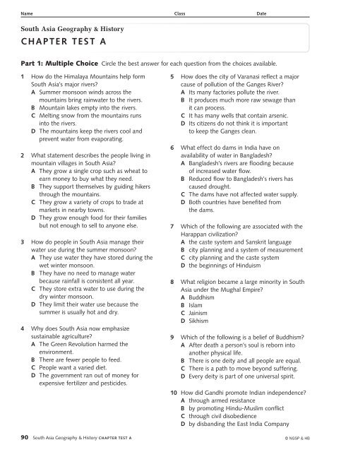
Part 1: Multiple Choice Circle the best answer for each question from the choices available.<br />
1 How do the Himalaya Mountains help form<br />
<strong>South</strong> <strong>Asia</strong>’s major rivers?<br />
a Summer monsoon winds across the<br />
mountains bring rainwater to the rivers.<br />
B Mountain lakes empty into the rivers.<br />
C Melting snow from the mountains runs<br />
into the rivers.<br />
D The mountains keep the rivers cool and<br />
prevent water from evaporating.<br />
2 What statement describes the people living in<br />
mountain villages in <strong>South</strong> <strong>Asia</strong>?<br />
a They grow a single crop such as wheat to<br />
earn money to buy what they need.<br />
B They support themselves by guiding hikers<br />
through the mountains.<br />
C They grow a variety of crops to trade at<br />
markets in nearby towns.<br />
D They grow enough food for their families<br />
but not enough to sell to anyone else.<br />
3 How do people in <strong>South</strong> <strong>Asia</strong> manage their<br />
water use during the summer monsoon?<br />
a They use water they have stored during the<br />
wet winter monsoon.<br />
B They have no need to manage water<br />
because rainfall is consistent all year.<br />
C They store extra water to use during the<br />
dry winter monsoon.<br />
D They limit their water use because the<br />
summer is usually hot and dry.<br />
4 Why does <strong>South</strong> <strong>Asia</strong> now emphasize<br />
sustainable agriculture?<br />
a The Green Revolution harmed the<br />
environment.<br />
B There are fewer people to feed.<br />
C People want a varied diet.<br />
D The government ran out of money for<br />
expensive fertilizer and pesticides.<br />
90 <strong>South</strong> <strong>Asia</strong> <strong>Geography</strong> & <strong>History</strong> <strong>Chapter</strong> <strong>test</strong> a<br />
5 How does the city of Varanasi reflect a major<br />
cause of pollution of the Ganges River?<br />
a Its many factories pollute the river.<br />
B It produces much more raw sewage than<br />
it can process.<br />
C It has many wells that contain arsenic.<br />
D Its citizens do not think it is important<br />
to keep the Ganges clean.<br />
6 What effect do dams in India have on<br />
availability of water in Bangladesh?<br />
a Bangladesh’s rivers are flooding because<br />
of increased water flow.<br />
B Reduced flow to Bangladesh’s rivers has<br />
caused drought.<br />
C The dams have not affected water supply.<br />
D Both countries have benefited from<br />
the dams.<br />
7 Which of the following are associated with the<br />
Harappan civilization?<br />
a the caste system and Sanskrit language<br />
B city planning and a system of measurement<br />
C city planning and the caste system<br />
D the beginnings of Hinduism<br />
8 What religion became a large minority in <strong>South</strong><br />
<strong>Asia</strong> under the Mughal Empire?<br />
a Buddhism<br />
B Islam<br />
C Jainism<br />
D Sikhism<br />
9 Which of the following is a belief of Buddhism?<br />
a After death a person’s soul is reborn into<br />
another physical life.<br />
B There is one deity and all people are equal.<br />
C There is a path to move beyond suffering.<br />
D Every deity is part of one universal spirit.<br />
10 How did Gandhi promote Indian independence?<br />
a through armed resistance<br />
B by promoting Hindu-Muslim conflict<br />
C through civil disobedience<br />
D by disbanding the East India Company<br />
© NGSP & HB
Name Class Date<br />
<strong>South</strong> <strong>Asia</strong> <strong>Geography</strong> & <strong>History</strong><br />
<strong>Chapter</strong> <strong>test</strong> a<br />
Part 2: Interpret Maps Use the map and your knowledge of <strong>South</strong> <strong>Asia</strong> to answer the questions below.<br />
60°E 70°E<br />
80°E<br />
90°E<br />
20°N<br />
10°N<br />
30°N<br />
PA K I S TA N<br />
Karachi<br />
Tropic of Cancer<br />
Arabian<br />
Sea<br />
Mumbai<br />
(Bombay)<br />
Population Density<br />
One dot represents<br />
100,000 people<br />
11 What part of Pakistan is most densely<br />
populated?<br />
a the area around Islamabad<br />
B the area around Karachi<br />
C the eastern border area near India<br />
D the far western area<br />
Islamabad<br />
Delhi<br />
Bangalore<br />
(Bengaluru)<br />
NGWG_TE_U09_C17_EM_M015<br />
FA10 <strong>South</strong> <strong>Asia</strong> Population Density<br />
First Proof<br />
01/26/11<br />
12 What do the cities of Delhi, Islamabad, and<br />
Dhaka have in common that supports their<br />
dense populations?<br />
a location on a coast<br />
B location near a major river<br />
C location south of the Tropic of Cancer<br />
D location near the Himalaya Mountains<br />
south asIa PoPulatIon densIty<br />
I N D I A<br />
0 250 500 Miles<br />
0 250 500 Kilometers<br />
N E P A L<br />
Kolkata<br />
(Calcutta)<br />
SRI LANKA<br />
BHUTAN<br />
BANGLADESH<br />
Bay of<br />
Bengal<br />
W<br />
INDIAN OCEAN<br />
Dhaka<br />
N<br />
S<br />
E<br />
13 What two densely populated cities are located<br />
near the Ganges Delta?<br />
a Bengaluru and Mumbai<br />
B Islamabad and Karachi<br />
C Kolkata and Dhaka<br />
D Kolkata and Delhi<br />
Constructed Response Write the answer to each question in the space provided.<br />
14 What geographic features are common to the least densely populated areas in <strong>South</strong> <strong>Asia</strong>?<br />
© NGSP & HB <strong>South</strong> <strong>Asia</strong> <strong>Geography</strong> & <strong>History</strong> <strong>Chapter</strong> <strong>test</strong> a 91
Name Class Date<br />
<strong>South</strong> <strong>Asia</strong> <strong>Geography</strong> & <strong>History</strong><br />
ChAPter teSt A<br />
Part 3: Interpret Charts Use the chart and your knowledge of <strong>South</strong> <strong>Asia</strong> to answer<br />
the questions below.<br />
IndIa’s GraIn ProduCtIon and<br />
PoPulatIon (1950–2008)<br />
Food Grain<br />
Production<br />
(millions of<br />
metric tons)<br />
15 In what year were the first effects of the Green<br />
Revolution seen?<br />
A 1960<br />
B 1970<br />
C 1980<br />
D 1990<br />
16 Which statement correctly summarizes the<br />
changes shown by the chart?<br />
A Food grain and wheat both decreased.<br />
B Wheat and population increased, but food<br />
grain decreased.<br />
C Food grain, wheat, and population<br />
all increased.<br />
D Food grain and wheat increased, but<br />
population decreased.<br />
Wheat<br />
Production<br />
(millions of<br />
metric tons)<br />
Population<br />
(millions)<br />
1950 50.8 6.4 361<br />
1960 82.0 10.3 439<br />
1970 108.4 20.0 548<br />
1980 129.6 31.8 683<br />
1990 176.4 49.8 846<br />
2000 201.6 76.3 1,000<br />
2008 227.8 78.0 1,148<br />
Sources: CIA Factbook; Indian National Science Academy<br />
17 How much food grain per person did India<br />
produce in 2008?<br />
A about 0.07 metric tons<br />
B about 0.14 metric tons<br />
C about 0.20 metric tons<br />
D about 2 metric tons<br />
Constructed response Use a complete sentence to write the answer in the space provided.<br />
18 What conclusions can you draw from the chart about India’s ability to feed its population<br />
in 2008 compared to 1950?<br />
92 <strong>South</strong> <strong>Asia</strong> <strong>Geography</strong> & <strong>History</strong> ChAPter teSt A<br />
© NGSP & HB
Name Class Date<br />
<strong>South</strong> <strong>Asia</strong> <strong>Geography</strong> & <strong>History</strong><br />
ChapTEr TEST a<br />
Part 4: Document-Based Question Use the documents and your knowledge of <strong>South</strong> <strong>Asia</strong> to answer<br />
the questions below.<br />
Introduction<br />
India came under direct British rule at the end of the Mughal Empire in 1858. Mohandas Gandhi was a<br />
lawyer who helped lead the campaign for India’s independence from Britain in the 1930s. He told Indians to<br />
disobey British laws but not to use violence. In July 1947, Great Britain passed the India Independence Act.<br />
The act divided, or partitioned, India into two separate independent countries: India and Pakistan, East and<br />
West. East Pakistan became Bangladesh in 1971.<br />
Objective: Analyze the effects of the Partition of India in 1947.<br />
DOCUMENT 1 Graphs of Religion in India, Pakistan, and Bangladesh, 2010<br />
INDIA<br />
total pop. 1,173,108,018<br />
Source: CIA Factbook<br />
Other 6.1%<br />
(Christians, Sikhs, and<br />
others unspecified)<br />
Muslim<br />
13.4%<br />
Hindu<br />
80.5%<br />
Other 5%<br />
(Hindus and<br />
Christians)<br />
PAKISTAN<br />
total pop. 177,276,594<br />
Muslim<br />
95%<br />
Other .9%<br />
(unspecified)<br />
BANGLADESH<br />
total pop. 158,065,841<br />
Constructed Response Use complete sentences to write the answers in the space provided.<br />
19 Compare the number of Muslims in each country.<br />
20 Which country has the least variety of religion? Use data from the graphs to support your answer.<br />
Hindu<br />
9.6%<br />
Muslim<br />
89.5%<br />
© NGSP & HB <strong>South</strong> <strong>Asia</strong> <strong>Geography</strong> & <strong>History</strong> ChapTEr TEST a 93
DOCUMENT 2 Quotation from a prayer by Mohandas Gandhi, January 26, 1948<br />
I wonder if we can remain free from the fever of power politics, or the bid for power which<br />
afflicts the political world, the East and the West. [Let] us permit ourselves to hope that though<br />
geographically and politically India is divided into two, at heart we shall ever be friends and brothers<br />
helping and respecting one another and be one for the outside world.<br />
Source: M. K. Gandhi, Delhi Diary, The Essential Gandhi, New York: Random House, 1962<br />
Constructed Response Use complete sentences to write the answers in the space provided.<br />
21 Based on this quotation, how do you think Gandhi felt about the Partition of India?<br />
22 How does the situation in Kashmir reflect India and Pakistan’s ability to live up to Gandhi’s hope?<br />
DOCUMENT 3 Photograph of<br />
Indian refugees on top of train cars<br />
in Amritsar, India, October 1947.<br />
Amritsar is located in western India<br />
near the border with Pakistan.<br />
Constructed Response Use complete sentences to write the answers in the space provided.<br />
23 How might the religion of the people on this train be different depending on whether the train was<br />
leaving Amritsar or arriving there from Pakistan?<br />
24 Based on the photograph, what can you infer about the government’s planning<br />
for the effects of Partition?<br />
Extended Response Write a paragraph to answer the question below. Use information from all three<br />
documents and your knowledge of <strong>South</strong> <strong>Asia</strong> in writing your paragraph. Use the back of this page or a<br />
separate piece of paper to write your answer.<br />
25 What were the short-term and long-term effects of Partition on the people of India,<br />
Pakistan, and Bangladesh?<br />
94 <strong>South</strong> <strong>Asia</strong> <strong>Geography</strong> & <strong>History</strong> CHAPTER TEST A<br />
© NGSP & HB