Rowley Sub-basin, Roebuck Basin, Release Areas W10-3, W10-4 ...
Rowley Sub-basin, Roebuck Basin, Release Areas W10-3, W10-4 ...
Rowley Sub-basin, Roebuck Basin, Release Areas W10-3, W10-4 ...

You also want an ePaper? Increase the reach of your titles
YUMPU automatically turns print PDFs into web optimized ePapers that Google loves.
WA<br />
Wigmore 1<br />
ODP 765A-D<br />
Whitetail 1<br />
5000<br />
Huntsman 1<br />
Minilya 1<br />
4000<br />
3000<br />
Lagrange 1<br />
<strong>Rowley</strong> Shoals<br />
Bedout 1<br />
<strong>W10</strong>-7<br />
Manaslu 1<br />
Nebo 1<br />
Darwin 1<br />
WA-435-P<br />
WA-436-P<br />
Phoenix 2<br />
Grey Rabbit 1<br />
Halo 1<br />
Huascaran 1<br />
Cimba 1<br />
Depuch 1<br />
WA-437-P<br />
118°<br />
Picard 1<br />
North Turtle 1<br />
Phoenix 1<br />
Keraudren 1<br />
WA-438-P<br />
<strong>W10</strong>-9<br />
NT<br />
SA<br />
TAS<br />
QLD<br />
NSW<br />
VIC<br />
0 100 km<br />
<strong>W10</strong>-8<br />
<strong>W10</strong>-5<br />
<strong>W10</strong>-6<br />
<strong>W10</strong>-4<br />
2000<br />
<strong>W10</strong>-3<br />
1000<br />
East Mermaid 1<br />
W08-13<br />
120°<br />
W09-1<br />
Barcoo 1 ST2<br />
W09-2<br />
South Galapagos 1<br />
500<br />
W09-3<br />
200<br />
WA-378-P<br />
W09-4<br />
Trochus 1<br />
Lynher 1 16°<br />
WA-415-P<br />
WA-416-P<br />
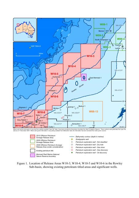
Where well symbol information is sourced from publicly available "open file" data, it has been provided by Geoscience Australia from Well Completion Reports. These symbols were generated from open file<br />
data as at 11 December 2009. Where well symbol information is not publicly available from titleholders' data, the information has been extracted from other public sources.<br />
Figure 1.<br />
2010 Offshore Petroleum<br />
Acreage <strong>Release</strong> Area<br />
2009 Offshore Petroleum<br />
Acreage <strong>Release</strong> Area<br />
2008 Offshore Petroleum Acreage<br />
<strong>Release</strong> Area (under consideration)<br />
Existing petroleum title<br />
Mermaid Reef Marine National<br />
Nature Reserve boundary<br />
200<br />
Bathymetry contour (depth in metres)<br />
Stratigraphic well<br />
Petroleum exploration well - Not classified<br />
Petroleum exploration well - Dry hole<br />
Petroleum exploration well - Gas show<br />
Petroleum exploration well - Gas discovery<br />
Petroleum exploration well - Oil discovery<br />
Location of <strong>Release</strong> <strong>Areas</strong> <strong>W10</strong>-3, <strong>W10</strong>-4, <strong>W10</strong>-5 and <strong>W10</strong>-6 in the <strong>Rowley</strong><br />
<strong>Sub</strong>-<strong>basin</strong>, showing existing petroleum titled areas and significant wells.<br />
50<br />
18°<br />
09-4231-1