Rowley Sub-basin, Roebuck Basin, Release Areas W10-3, W10-4 ...
Rowley Sub-basin, Roebuck Basin, Release Areas W10-3, W10-4 ...
Rowley Sub-basin, Roebuck Basin, Release Areas W10-3, W10-4 ...

Create successful ePaper yourself
Turn your PDF publications into a flip-book with our unique Google optimized e-Paper software.
MAP SHEET<br />
SD 50<br />
MAP SHEET<br />
SE 50<br />
(<strong>Rowley</strong> Shoals)<br />
1995<br />
18°19'55.15"S<br />
118°10'04.68"E<br />
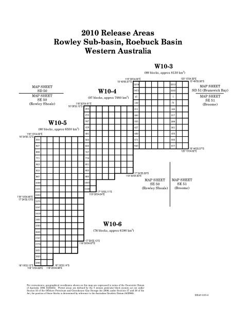
2010 <strong>Release</strong> <strong>Areas</strong><br />
<strong>Rowley</strong> <strong>Sub</strong>-<strong>basin</strong>, <strong>Roebuck</strong> <strong>Basin</strong><br />
Western Australia<br />
<strong>W10</strong>-5<br />
(80 blocks, approx 6550 km 2 )<br />
118°10'04.63"E<br />
16°34'55.12"S<br />
555<br />
118°10'04.65"E<br />
17°24'55.13"S<br />
627<br />
699<br />
771<br />
843<br />
915<br />
987<br />
1059<br />
1131<br />
1203<br />
1275<br />
1347<br />
1419<br />
1491<br />
1563<br />
1635<br />
1707<br />
1779<br />
1851<br />
1923<br />
18°19'55.14"S<br />
118°25'04.68"E<br />
118°50'04.61"E<br />
16°09'55.10"S<br />
203<br />
275<br />
347<br />
419<br />
491<br />
563<br />
635<br />
707<br />
779<br />
851<br />
923<br />
995<br />
1067<br />
<strong>W10</strong>-4<br />
(97 blocks, approx 7950 km 2 )<br />
1139<br />
17°19'55.11"S<br />
119°00'04.64"E<br />
17°59'55.13"S<br />
118°50'04.67"E<br />
<strong>W10</strong>-6<br />
119°30'04.60"E<br />
15°49'55.07"S<br />
3379<br />
(76 blocks, approx 6190 km 2 )<br />
For convenience, geographical coordinates shown on this map are expressed in terms of the Geocentric Datum<br />
of Australia 1994 (GDA94). Permit areas are defined by the 5 minute graticular block system set out under<br />
Section 33 of the Offshore Petroleum and Greenhouse Gas Storage Act 2006; under Sections 37 and 38 of the<br />
Act, the position of those blocks is determined by reference to the Australian Geodetic Datum (AGD66).<br />
3451<br />
67<br />
139<br />
211<br />
283<br />
355<br />
427<br />
499<br />
571<br />
643<br />
<strong>W10</strong>-3<br />
(99 blocks, approx 8130 km 2 )<br />
17°04'55.09"S<br />
119°30'04.63"E<br />
MAP SHEET<br />
SE 50<br />
(<strong>Rowley</strong> Shoals)<br />
3313<br />
3385<br />
1<br />
73<br />
145<br />
217<br />
289<br />
361<br />
433<br />
505<br />
577<br />
120°15'04.59"E<br />
15°49'55.06"S<br />
MAP SHEET<br />
SD 51 (Brunswick Bay)<br />
MAP SHEET<br />
SE 51<br />
(Broome)<br />
16°44'55.07"S<br />
120°15'04.62"E<br />
MAP SHEET<br />
SE 51<br />
(Broome)<br />
IDEAS 9155-8