Scott - Goldie Creek - District of North Vancouver
Scott - Goldie Creek - District of North Vancouver
Scott - Goldie Creek - District of North Vancouver

You also want an ePaper? Increase the reach of your titles
YUMPU automatically turns print PDFs into web optimized ePapers that Google loves.
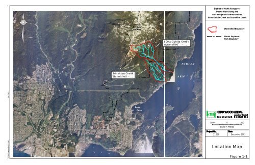
31-288\Drawings\Fig1-1.DWG Dec.05/03<br />
Sunshine <strong>Creek</strong><br />
Watershed<br />
Mount<br />
Seymour<br />
Ski Area<br />
Deep<br />
Cove<br />
<strong>Scott</strong> - <strong>Goldie</strong> <strong>Creek</strong><br />
Sunshine <strong>Creek</strong><br />
<strong>Scott</strong>-<strong>Goldie</strong> <strong>Creek</strong><br />
Watershed<br />
A R M<br />
I N D I A N<br />
<strong>District</strong> <strong>of</strong> <strong>North</strong> <strong>Vancouver</strong><br />
Debris Flow Study and<br />
Risk Mitigation Alternatives for<br />
<strong>Scott</strong>-<strong>Goldie</strong> <strong>Creek</strong> and Sunshine <strong>Creek</strong><br />
1000<br />
Watershed Boundary<br />
Mount Seymour<br />
Park Boundary<br />
0<br />
Scale in Metres<br />
1000<br />
31.288 December 2003<br />
Location Map<br />
Figure 1-1
31.288\Drawings\31288Fig1-2.Dwg Dec.05/03<br />
Mount<br />
Seymour<br />
Ski Area<br />
Mount Seymour<br />
Provincial Park<br />
<strong>Scott</strong> - <strong>Goldie</strong> <strong>Creek</strong><br />
Sunshine <strong>Creek</strong><br />
I N D I A N<br />
A R M<br />
<strong>District</strong> <strong>of</strong> <strong>North</strong> <strong>Vancouver</strong><br />
Debris Flow Study and<br />
Risk Mitigation Alternatives for<br />
<strong>Scott</strong>-<strong>Goldie</strong> <strong>Creek</strong> and Sunshine <strong>Creek</strong><br />
Legend<br />
400<br />
Watershed Boundary<br />
Property Line<br />
Mount Seymour<br />
Park Boundary<br />
0<br />
Scale in Metres<br />
400<br />
31.288 December 2003<br />
Photo Mosaic <strong>of</strong><br />
<strong>Scott</strong>-<strong>Goldie</strong> <strong>Creek</strong><br />
and Sunshine <strong>Creek</strong><br />
Watersheds<br />
Figure 1-2
31.288\Drawings\31288Fig1-3.Dwg Dec.05/03<br />
200<br />
Mount Seymour Provincial Park<br />
Sunshine<br />
31.288 December 2003<br />
0<br />
Scale in Metres<br />
<strong>Creek</strong><br />
200<br />
<strong>Scott</strong>-<br />
<strong>Goldie</strong><br />
<strong>Creek</strong><br />
Legend<br />
<strong>District</strong> <strong>of</strong><br />
<strong>North</strong> <strong>Vancouver</strong><br />
<strong>District</strong> <strong>of</strong> <strong>North</strong> <strong>Vancouver</strong> Debris Flow Study and<br />
Risk Mitigation Alternatives for <strong>Scott</strong>-<strong>Goldie</strong> <strong>Creek</strong> and Sunshine <strong>Creek</strong><br />
Property Ownership<br />
Indian<br />
Arm<br />
Private<br />
Figure 1-3
31-288\Fig2-1.DWG Dec.20/02<br />
974.8<br />
.7<br />
982.9<br />
S<br />
991.0<br />
999.4<br />
1005.5<br />
997.4<br />
S<br />
Seymour<br />
Mountain<br />
1012.4<br />
1006.2<br />
999.2<br />
S<br />
1026.3<br />
1017.2<br />
1016.5<br />
933.5<br />
SEYMOUR ROAD<br />
1023.0<br />
1019.2<br />
1022.6<br />
927.4<br />
1021.5<br />
923.7<br />
1020.2<br />
924.4<br />
915.8<br />
Debris flow deposit (from <strong>Scott</strong>-<strong>Goldie</strong> avulsion) at intersection with Sunshine <strong>Creek</strong><br />
F at 250 m elevation, February 2002.<br />
D<br />
G<br />
1058.2<br />
1025.7<br />
997.7<br />
955.3<br />
Flower<br />
Lake<br />
Right bank <strong>of</strong> <strong>Scott</strong>-<strong>Goldie</strong> <strong>Creek</strong> (290 m elevation) at possible avulsion route into the drainage <strong>of</strong> Sunshine <strong>Creek</strong>, February 2002.<br />
Sunshine <strong>Creek</strong> at Firelane 8, February 2002.<br />
962.4<br />
Mount Seymour<br />
Provincial Park<br />
S<br />
972.8<br />
S<br />
Section 6<br />
S<br />
T5<br />
S<br />
T6<br />
S<br />
S<br />
S<br />
S<br />
Section 5<br />
E<br />
S<br />
S<br />
S<br />
T4<br />
T4<br />
S<br />
T3<br />
T2<br />
T3<br />
S<br />
T5<br />
Seymour Park<br />
Boundary<br />
T2<br />
Section 4<br />
<strong>Scott</strong> - <strong>Goldie</strong><br />
Possible<br />
Avulsion<br />
Route<br />
Percy<br />
E Debris slides along upper reaches <strong>of</strong> <strong>Scott</strong>-<strong>Goldie</strong> <strong>Creek</strong>, October 2001.<br />
B<br />
<strong>Creek</strong><br />
G<br />
F<br />
Sunshine<br />
D<br />
<strong>Scott</strong>-<strong>Goldie</strong> <strong>Creek</strong> at Indian Arm, July 1997<br />
T1<br />
T1<br />
Section 3<br />
W<br />
<strong>Creek</strong><br />
<strong>Creek</strong><br />
Section 2<br />
FIRELANE 7<br />
W<br />
Vapour <strong>Creek</strong><br />
H<br />
FIRELANE 8<br />
Water Intake<br />
C<br />
Section 1<br />
INDIAN<br />
ARM<br />
B<br />
A<br />
A Overview <strong>of</strong> <strong>Scott</strong>-<strong>Goldie</strong> <strong>Creek</strong>, 2001.<br />
100 0 100<br />
Scale in Metres<br />
Fireline 8 crossing <strong>of</strong> <strong>Scott</strong>-<strong>Goldie</strong> <strong>Creek</strong>, October 2001<br />
Watershed Area<br />
<strong>Scott</strong>-<strong>Goldie</strong> <strong>Creek</strong> 1.7 km 2<br />
Sunshine <strong>Creek</strong> 1.2 km 2<br />
Debris Flow Study and<br />
Risk Mitigation Alternatives for <strong>Scott</strong>-<strong>Goldie</strong> <strong>Creek</strong> and Sunshine <strong>Creek</strong><br />
C<br />
H Overview <strong>of</strong> Sunshine <strong>Creek</strong> at Indian Arm, 2001.<br />
Hydrologic Landforms<br />
Swamp, Bog<br />
Helicopter Logged<br />
Mass Movement Processes<br />
and Land Forms<br />
Avalanche Trimline<br />
Potential Avulsion Routes<br />
for Debris Flows and<br />
Debris Floods<br />
Potential Displacement<br />
Wave from Rockfall/Rockslide<br />
into Lake<br />
Approximate Photo<br />
Location and Direction<br />
Rockfall Scarp (recent)<br />
Sackung/Antislope Scarp<br />
Translational Slide or Road<br />
Fill Slope Failure<br />
Gullies in Cohesionless<br />
Materials<br />
Bank Erosion<br />
Geomorphic Map <strong>of</strong><br />
<strong>Scott</strong>-<strong>Goldie</strong> <strong>Creek</strong> and Sunshine <strong>Creek</strong> Watersheds<br />
200<br />
187.4<br />
A<br />
Definite Stream<br />
Indefinite Stream<br />
Lake<br />
Topography<br />
Infrastructure<br />
Trail<br />
Bridge<br />
Building<br />
Hydro Pole<br />
Vegetation<br />
Bank Full Stream Channel<br />
Shoreline<br />
Index Contour (25 m)<br />
Intermediate Contour (5 m)<br />
Spot Height (m)<br />
Road<br />
Gravel Road<br />
Property Line<br />
Snag<br />
Tall Tree<br />
Treeline<br />
Area <strong>of</strong> Potential Debris Flow<br />
or Debris Slide Initiation<br />
Area <strong>of</strong> Debris Accumulation<br />
Modern <strong>Creek</strong> Fan<br />
Watershed Boundary<br />
Bedrock (Selected Locations)<br />
Colluvium (Selected Locations)<br />
Tributary Debris Slide, Rock<br />
Slide Debris Flow Trajectory<br />
Potential Landslide<br />
Dam Location<br />
Ravelling<br />
Figure 2-1
31-288\Drawings\Fig2-2.DWG Dec.05/03<br />
Bridge<br />
FIRELANE 8<br />
<strong>Scott</strong> - <strong>Goldie</strong> <strong>Creek</strong><br />
Waterfall<br />
HAZARD ZONE<br />
RED<br />
ORANGE<br />
YELLOW<br />
HAZARD ZONE DEFINITION<br />
v (m/s) d (m) D (m)<br />
>3 >3 >2<br />
1-3 1-3 1-2<br />
Fig3-1.DWG Dec.05/03<br />
Approximate<br />
Location <strong>of</strong><br />
1000 m 3<br />
Debris Barrier<br />
Sunshine<br />
<strong>Creek</strong><br />
FIRELANE 8<br />
Approximate<br />
Location <strong>of</strong><br />
500 m 3<br />
Debris Barrier<br />
FIRELANE 7<br />
INDIAN<br />
Water Intake<br />
ARM<br />
<strong>District</strong> <strong>of</strong> <strong>North</strong> <strong>Vancouver</strong><br />
Debris Flow Study and<br />
Risk Mitigation Alternatives for<br />
<strong>Scott</strong>-<strong>Goldie</strong> <strong>Creek</strong> and Sunshine <strong>Creek</strong><br />
Legend<br />
Notes:<br />
1.<br />
2.<br />
3.<br />
50<br />
Building<br />
Dock<br />
Property Boundary<br />
Possible Avulsion Route<br />
from <strong>Scott</strong>-<strong>Goldie</strong> <strong>Creek</strong><br />
Contours are based on photogrammetry<br />
and are approximate only.<br />
The dimensions and location <strong>of</strong> mapping<br />
features are approximate and are based<br />
on 1996 colour air photos.<br />
Property lines are based on cadastral<br />
information provided by the <strong>District</strong> <strong>of</strong><br />
<strong>North</strong> <strong>Vancouver</strong>.<br />
0<br />
Scale in Metres<br />
50<br />
31.288 December 2003<br />
Debris Barrier Options<br />
for Sunshine <strong>Creek</strong><br />
Figure 3-1
Fig3-2.DWG Dec.05/03<br />
4.0 m<br />
Note:<br />
4.0 m<br />
All dimensions are approximate<br />
and would have to be adjusted<br />
depending on the chosen location.<br />
31.288 December 2003<br />
Scale 1:100<br />
1.0 m<br />
0.5<br />
1<br />
15.0 m<br />
10.0 m<br />
1<br />
8.0 m<br />
Cross-Section<br />
(Looking Downstream)<br />
Steel Plated<br />
on Upstream<br />
Side<br />
1<br />
Section<br />
Impact<br />
Existing<br />
Surface<br />
<strong>District</strong> <strong>of</strong> <strong>North</strong> <strong>Vancouver</strong> Debris Flow Study and<br />
Excavated<br />
Surface<br />
Existing<br />
Surface<br />
Excavated<br />
Surface<br />
Risk Mitigation Alternatives for <strong>Scott</strong>-<strong>Goldie</strong> <strong>Creek</strong> and Sunshine <strong>Creek</strong><br />
Concept Plan for Debris Barrier<br />
at Sunshine <strong>Creek</strong> Figure 3-2
0.9<br />
0.8<br />
0.7<br />
0.6<br />
0.5<br />
0.4<br />
0.3<br />
0.2<br />
0.1<br />
WATERCONTENTIN%<br />
100<br />
1.0<br />
90 80 70 60 50 40 30 20 10 0<br />
0.0<br />
0.0 0.1 0.2 0.3 0.4 0.5 0.6 0.7 0.8 0.9<br />
SEDIMENTCONCENTRATIONBYVOLUME,C<br />
C<br />
C<br />
1+(G-1)C<br />
Specific Gravity<br />
G=2.65<br />
Classification <strong>of</strong><br />
Mass Movement Processes<br />
w<br />
=<br />
v<br />
G<br />
v<br />
v<br />
30-100<br />
10-30<br />
5-10<br />
1-10<br />
2-5<br />
1-3<br />
1.0<br />
FigureA-1
31-288\Drawings\FigC-1.DWG Dec.05/03<br />
Elevation above Sea Level (m)<br />
1000<br />
900<br />
800<br />
700<br />
600<br />
500<br />
400<br />
300<br />
200<br />
100<br />
Flower<br />
Lake<br />
0<br />
3500<br />
4°<br />
T6<br />
Section 6<br />
8°<br />
12°<br />
T4<br />
Lower Bounds<br />
<strong>of</strong> Ski Area<br />
T2<br />
11°<br />
T5<br />
3°<br />
16°<br />
3000<br />
21°<br />
16°<br />
11°<br />
6°<br />
26°<br />
25° 13°<br />
32°<br />
40°<br />
18°<br />
Section 5<br />
28°<br />
17°<br />
23°<br />
19°<br />
34°<br />
T3<br />
14°<br />
16°<br />
Several<br />
Debris<br />
Slides<br />
2500<br />
26°<br />
36°<br />
Debris<br />
Slide<br />
36°<br />
Debris<br />
Slide<br />
2000<br />
17°<br />
Section 4<br />
Canyon<br />
14°<br />
1500<br />
Horizontal Distance (m)<br />
15°<br />
Section 3<br />
T1<br />
24°<br />
27°<br />
36°<br />
Section 2<br />
12°<br />
Possible<br />
Avulsion Route<br />
into Sunshine <strong>Creek</strong><br />
1000<br />
500<br />
17°<br />
Section 1<br />
200<br />
Firelane 8 Waterfall<br />
19°<br />
0<br />
1000<br />
900<br />
800<br />
700<br />
600<br />
500<br />
400<br />
300<br />
100<br />
0<br />
<strong>District</strong> <strong>of</strong> <strong>North</strong> <strong>Vancouver</strong><br />
Debris Flow Study and<br />
Risk Mitigation Alternatives for<br />
<strong>Scott</strong>-<strong>Goldie</strong> <strong>Creek</strong> and Sunshine <strong>Creek</strong><br />
Legend<br />
16°<br />
16°<br />
<strong>Creek</strong> Pr<strong>of</strong>ile<br />
Gradient in <strong>Creek</strong> Section<br />
Tributary <strong>Creek</strong><br />
Gradient in Tributary<br />
<strong>Creek</strong> Section<br />
Note:<br />
Vertical scale is exaggerated.<br />
Horizontal 1:15,000 Vertical 1:5,000<br />
Scale in Metres<br />
31.288 December 2003<br />
Pr<strong>of</strong>ile <strong>of</strong><br />
<strong>Scott</strong>-<strong>Goldie</strong> <strong>Creek</strong><br />
Figure C-1
31-288\Drawings\FigC-2.DWG Dec.05/03<br />
Elevation above Sea Level (m)<br />
800<br />
700<br />
600<br />
500<br />
400<br />
300<br />
200<br />
100<br />
0<br />
2500<br />
18°<br />
T5<br />
19°<br />
2000<br />
23°<br />
T4<br />
22°<br />
24°<br />
1500<br />
Avulsion Route From <strong>Scott</strong>-<strong>Goldie</strong> <strong>Creek</strong><br />
17°<br />
33°<br />
25°<br />
24°<br />
T3<br />
20°<br />
30°<br />
40°<br />
Horizontal Distance (m)<br />
26°<br />
15°<br />
12°<br />
1000<br />
24°<br />
24°<br />
T2<br />
26°<br />
34°<br />
Firelane 8<br />
T1<br />
29°<br />
10°<br />
9°<br />
15°<br />
15°<br />
10°<br />
35°<br />
14°<br />
500<br />
4°<br />
11°<br />
20°<br />
14°<br />
0<br />
800<br />
700<br />
600<br />
500<br />
400<br />
300<br />
200<br />
100<br />
0<br />
<strong>District</strong> <strong>of</strong> <strong>North</strong> <strong>Vancouver</strong><br />
Debris Flow Study and<br />
Risk Mitigation Alternatives for<br />
<strong>Scott</strong>-<strong>Goldie</strong> <strong>Creek</strong> and Sunshine <strong>Creek</strong><br />
Legend<br />
8 °<br />
8 °<br />
<strong>Creek</strong> Pr<strong>of</strong>ile<br />
Gradient in <strong>Creek</strong> Section<br />
Tributary <strong>Creek</strong><br />
Gradient in Tributary<br />
<strong>Creek</strong> Section<br />
Note:<br />
Vertical scale is exaggerated.<br />
Horizontal 1:10,000 Vertical 1:5,000<br />
Scale in Metres<br />
31.288 December 2003<br />
Pr<strong>of</strong>ile <strong>of</strong><br />
Sunshine <strong>Creek</strong><br />
Figure C-2