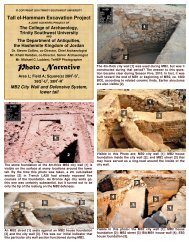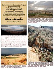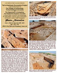
Explorations on the - Tall el-Hammam Excavation Project, Jordan
Explorations on the - Tall el-Hammam Excavation Project, Jordan
Explorations on the - Tall el-Hammam Excavation Project, Jordan

You also want an ePaper? Increase the reach of your titles
YUMPU automatically turns print PDFs into web optimized ePapers that Google loves.
BIBLICAL RESEARCH BULLETIN<br />
The Academic Journal of Trinity Southwest University<br />
ISSN 1938-694X<br />
Volume II<br />
Number 18<br />
<str<strong>on</strong>g>Explorati<strong>on</strong>s</str<strong>on</strong>g> <strong>on</strong> <strong>the</strong> Eastern <strong>Jordan</strong> Disk<br />
Steven Collins<br />
Abstract:<br />
Before my research into <strong>the</strong> biblical parameters for <strong>the</strong> locati<strong>on</strong> of Sodom, few scholars had paid much<br />
attenti<strong>on</strong> to <strong>the</strong> area specified by Genesis 13:1-12 as <strong>the</strong> actual place: <strong>the</strong> eastern Kikkar of <strong>the</strong> <strong>Jordan</strong><br />
River, just north of <strong>the</strong> Dead Sea. This paper applies those parameters, in <strong>the</strong> form of a criterial screen, to<br />
various “Sodom candidate” sites, and reveals that <strong>Tall</strong> <strong>el</strong>-<strong>Hammam</strong> is <strong>the</strong> most reas<strong>on</strong>able choice for <strong>the</strong><br />
infamous city.<br />
© Copyright 2002, Trinity Southwest University<br />
Special copyright, publicati<strong>on</strong>, and/or citati<strong>on</strong> informati<strong>on</strong>: Biblical Research Bulletin is copyrighted<br />
by Trinity Southwest University. All rights reserved. Article c<strong>on</strong>tent remains <strong>the</strong> int<strong>el</strong>lectual property of<br />
<strong>the</strong> author. This article may be reproduced, copied, and distributed, as l<strong>on</strong>g as <strong>the</strong> following c<strong>on</strong>diti<strong>on</strong>s are<br />
met:<br />
1. If transmitted <strong>el</strong>ectr<strong>on</strong>ically, this article must be in its original, complete PDF file form. The PDF<br />
file may not be edited in any way, including <strong>the</strong> file name.<br />
2. If printed copies of all or a porti<strong>on</strong> of this article are made for distributi<strong>on</strong>, <strong>the</strong> copies must<br />
include complete and unmodified copies of <strong>the</strong> article’s cover page (i.e., this page).<br />
3. Copies of this article may not be charged for, except for nominal reproducti<strong>on</strong> costs.<br />
4. Copies of this article may not be combined or c<strong>on</strong>solidated into a larger work in any format <strong>on</strong><br />
any media, without <strong>the</strong> written permissi<strong>on</strong> of Trinity Southwest University.<br />
Brief quotati<strong>on</strong>s appearing in reviews and o<strong>the</strong>r works may be made, so l<strong>on</strong>g as appropriate credit is given<br />
and/or source citati<strong>on</strong> is made.<br />
This article is adapted from a paper presented to <strong>the</strong> annual meeting of <strong>the</strong> Near East Archaeological<br />
Society in 2002. Some format irregularities may exist.<br />
© Copyright 2002 by Trinity Southwest University Press, 5600 Eubank NE, Suite 130,<br />
Albuquerque, New Mexico 87111, USA; (505) 332-4253. All rights reserved. Printed in <strong>the</strong><br />
United States of America by Trinity Southwest University Press, a divisi<strong>on</strong> of CEM, Inc. No part<br />
of this work may be reproduced, stored in a retrieval system, or transmitted in any form or by<br />
any means, <strong>el</strong>ectr<strong>on</strong>ic, digital, mechanical, photocopying, recording, or o<strong>the</strong>rwise, without<br />
written permissi<strong>on</strong> from Trinity Southwest University Press.
<str<strong>on</strong>g>Explorati<strong>on</strong>s</str<strong>on</strong>g> <strong>on</strong> <strong>the</strong> Eastern <strong>Jordan</strong> Disk<br />
Steven Collins<br />
Dean, College of Archaeology,<br />
Trinity Southwest University<br />
Based <strong>on</strong> a careful analysis of <strong>the</strong> geographical, 1 chr<strong>on</strong>ological, 2 architectural, 3 and destructi<strong>on</strong> 4<br />
indicators found in <strong>the</strong> biblical account of <strong>the</strong> Cities of <strong>the</strong> Plain (<strong>the</strong> Cities of <strong>the</strong> <strong>Jordan</strong> Disk),<br />
it is possible to c<strong>on</strong>struct a criterial screen 5 whereby possible candidate sites for Sodom,<br />
Gomorrah, Admah, and Zeboiim could be identified, at least <strong>the</strong>oretically, by fi<strong>el</strong>dwork and<br />
excavati<strong>on</strong>. If <strong>the</strong>ir potential archaeological remains were not entir<strong>el</strong>y disintegrated to <strong>the</strong> point<br />
of sterility when <strong>the</strong>y were destroyed, <strong>the</strong>n some record of <strong>the</strong>ir existence may still survive and<br />
be discoverable via excavati<strong>on</strong>. If <strong>the</strong> nature of <strong>the</strong>ir destructi<strong>on</strong> was primarily by burning,<br />
wherein much of <strong>the</strong> artifactual evidence may remain in some state of preservati<strong>on</strong> as it does at<br />
numerous ancient Near Eastern sites <strong>on</strong>ce lev<strong>el</strong>ed by violent c<strong>on</strong>flagrati<strong>on</strong>, 6 <strong>the</strong>n <strong>the</strong>ir<br />
architectural features and vestiges of material culture may be available for investigati<strong>on</strong> and<br />
analysis.<br />
On <strong>the</strong> <strong>on</strong>e hand, <strong>the</strong> value of a criterial screen based <strong>on</strong> <strong>the</strong> r<strong>el</strong>evant biblical data is that a<br />
given candidate site could be evaluated as to its commensurability with probably <strong>the</strong> <strong>on</strong>ly written<br />
record of its existence, thus providing a reas<strong>on</strong>able means of identificati<strong>on</strong>, even if <strong>on</strong>ly<br />
tentative. 7 On <strong>the</strong> o<strong>the</strong>r hand, if <strong>the</strong> geographical, chr<strong>on</strong>ological, architectural, and destructi<strong>on</strong><br />
data drawn from <strong>the</strong> biblical narrative c<strong>on</strong>cerning Sodom and Gomorrah, Admah and Zeboiim<br />
1 S. Collins, "The Geography of <strong>the</strong> Cities of <strong>the</strong> Plain," Biblical Research Bulletin II.1 (2002). The clear biblical locati<strong>on</strong> for<br />
<strong>the</strong> Cities of <strong>the</strong> Plain, according to Genesis 13:1-12, is north of <strong>the</strong> Dead Sea <strong>on</strong> <strong>the</strong> east side of <strong>the</strong> <strong>Jordan</strong> River, a circular area<br />
given <strong>the</strong> Hebrew name kikkar.<br />
2 S. Collins, "A Chr<strong>on</strong>ology for <strong>the</strong> Cities of <strong>the</strong> Plain," BRB II.8 (2002). The story of Abram and Lot and <strong>the</strong> Cities of <strong>the</strong><br />
Plain, according to <strong>the</strong> biblical chr<strong>on</strong>ology, b<strong>el</strong><strong>on</strong>g to <strong>the</strong> Middle Br<strong>on</strong>ze Age.<br />
3 S. Collins, "The Architecture of Sodom," BRB II.14 (2002).<br />
4 S. Collins, "Terms of Destructi<strong>on</strong> for <strong>the</strong> Cities of <strong>the</strong> Plain," BRB II.16 (2002).<br />
5 See P. Briggs, Testing <strong>the</strong> Factuality of <strong>the</strong> C<strong>on</strong>quest of Ai Narrative in <strong>the</strong> Book of Joshua (Albuquerque: Trinity Southwest<br />
University Press, 2002). The dev<strong>el</strong>opment of <strong>the</strong> criterial screen is based <strong>on</strong> <strong>the</strong> true narrative representati<strong>on</strong> (TNR) <strong>the</strong>ory of<br />
J.W. Oller, Jr. For a summative discussi<strong>on</strong> of TNR <strong>the</strong>ory see J.W. Oller, Jr., and S. Collins, "The Logic of True Narratives,"<br />
BRB I.2 (2001); and S. Collins and J.W. Oller, Jr., "Biblical History as True Narrative Representati<strong>on</strong>," BRB I.3 (2001).<br />
6 The destructi<strong>on</strong> of ancient cities was almost always accompanied by fire, which usually leaves a t<strong>el</strong>ltale layer of ash and<br />
charred debris. However, if a burned site was left exposed to <strong>the</strong> <strong>el</strong>ements for a l<strong>on</strong>g period of time before being buried by<br />
subsequent habitati<strong>on</strong> and building activity, <strong>the</strong>n erosi<strong>on</strong>al processes could have removed most or all traces of ash and organic<br />
remains. In <strong>the</strong>se cases, <strong>the</strong> evidence of fire may be preserved in o<strong>the</strong>r ways, such as “burned” limest<strong>on</strong>e, vitrified (“re-fired”)<br />
ceramics, and mud bricks, etc.<br />
7 The identificati<strong>on</strong> of <strong>the</strong> city of Ai destroyed by Joshua is a case-in-point. The traditi<strong>on</strong>al site of Ai (et-T<strong>el</strong>l) did not have any<br />
strata that could possibly be associated with <strong>the</strong> time of Joshua (LB I/II). Thus, <strong>the</strong> story recorded in Joshua chapters seven and<br />
eight was declared by many to be an aetiological legend. However, six seas<strong>on</strong>s of excavati<strong>on</strong> (directed by B.G. Wood) at Khirbet<br />
<strong>el</strong>-Maqatir (just over a kilometer from et-T<strong>el</strong>l) revealed a fortified Canaanite garris<strong>on</strong> that was destroyed toward <strong>the</strong> end of LB I,<br />
exactly as <strong>the</strong> Bible describes. In <strong>the</strong> case of LB Ai, <strong>the</strong> identificati<strong>on</strong> was based primarily <strong>on</strong> <strong>the</strong> detailed biblical descripti<strong>on</strong> of<br />
<strong>the</strong> city and <strong>the</strong> battle that occurred <strong>on</strong> <strong>the</strong> associated terrain. See B.G. Wood, “Khirbet <strong>el</strong>-Maqatir, 1995-1998,” IEJ 50.1-2<br />
(2000) 123-130; B.G. Wood, “Khirbet <strong>el</strong>-Maqatir, 1999,” IEJ 50.3-4 (2000) 249-254; B.G. Wood, “Khirbet <strong>el</strong>-Maqatir, 2000,”<br />
IEJ 51.2 (2001) 246-252; and B.G. Wood, “Khirbet <strong>el</strong>-Maqatir 2000 Dig Report,” BS 13.3 (2000) 67-72.<br />
1
are c<strong>on</strong>firmed in <strong>the</strong> fi<strong>el</strong>d, <strong>the</strong>n <strong>the</strong> historical veracity of <strong>the</strong> biblical account of <strong>the</strong> Cities of <strong>the</strong><br />
Plain would be significantly dem<strong>on</strong>strated. Ei<strong>the</strong>r way, it would <strong>the</strong>n be very difficult to attribute<br />
<strong>the</strong> story, as many scholars do, to <strong>the</strong> imaginati<strong>on</strong> of a Persian Period Judahite priest writing<br />
propagandistic ficti<strong>on</strong>. 8<br />
DEVELOPING A CRITERIAL SCREEN<br />
Peter Briggs has set out <strong>the</strong> methodology of formulating a criterial screen for <strong>the</strong> purpose of<br />
locating and identifying a city/town based <strong>on</strong> data drawn from <strong>the</strong> biblical narrative:<br />
[A criterial screen] is <strong>the</strong> particular measure of empirical corresp<strong>on</strong>dence.... Through<br />
valid and correct hermeneutical procedure, <strong>the</strong> parameters of <strong>the</strong> criterial screen are<br />
derived from <strong>the</strong> text of <strong>the</strong> narrative. Each of <strong>the</strong> parameters describes an aspect of <strong>the</strong><br />
material time-space c<strong>on</strong>text of <strong>the</strong> narrative which must be true if <strong>the</strong> narrative is a TNR<br />
[true narrative representati<strong>on</strong> 9 ]. ...Extending <strong>the</strong> argument to <strong>the</strong> general c<strong>on</strong>diti<strong>on</strong>, if any<br />
given narrative is true, <strong>the</strong>n all of <strong>the</strong> criterial screen parameters validly and correctly<br />
derived from it must also be true. The greater <strong>the</strong> detail c<strong>on</strong>tained in <strong>the</strong> text of <strong>the</strong><br />
narrative, <strong>the</strong> larger <strong>the</strong> number of criterial screen parameters that can be derived from<br />
<strong>the</strong> text, and, <strong>the</strong>refore, <strong>the</strong> greater <strong>the</strong> c<strong>on</strong>fidence factor that is associated with <strong>the</strong> result<br />
of testing <strong>the</strong> criterial screen against <strong>the</strong> material time-space c<strong>on</strong>text of <strong>the</strong> narrative.<br />
...Not <strong>on</strong>ly are <strong>the</strong> parameters of <strong>the</strong> criterial screen c<strong>on</strong>diti<strong>on</strong>s which can ei<strong>the</strong>r be true or<br />
false, but <strong>the</strong>y are also mutually independent. That is, no parameter in <strong>the</strong> screen is<br />
functi<strong>on</strong>ally linked or statistically corr<strong>el</strong>ated with any o<strong>the</strong>r parameter. ...By definiti<strong>on</strong>,<br />
<strong>the</strong> parameters of <strong>the</strong> criterial screen validly and correctly reflect <strong>the</strong> narrative from<br />
which <strong>the</strong>y are derived. In general, <strong>the</strong> larger <strong>the</strong> number of parameters in <strong>the</strong> criterial<br />
screen, <strong>the</strong> more c<strong>on</strong>clusive <strong>the</strong> evidence in favor of a given factuality text result. ...If all<br />
[say ten or twenty 10 ] parameters are true, <strong>the</strong>n <strong>the</strong> evidence in favor of <strong>the</strong> narrative in<br />
questi<strong>on</strong> being factual would be comp<strong>el</strong>ling. If few or n<strong>on</strong>e of <strong>the</strong> parameters are true,<br />
<strong>the</strong>re would be comp<strong>el</strong>ling evidence that <strong>the</strong> narrative in questi<strong>on</strong> is n<strong>on</strong>factual. 11<br />
In <strong>the</strong> case of <strong>the</strong> search for <strong>the</strong> correct locati<strong>on</strong> and identity of <strong>the</strong> Cities of <strong>the</strong> Plain, my<br />
purpose for using such a criterial screen is not, necessarily, to validate <strong>the</strong> factuality of <strong>the</strong><br />
biblical narratives about Abraham and Lot. 12 My purpose is simply to use <strong>the</strong> data of <strong>the</strong> biblical<br />
text to ascertain, if possible, four things:<br />
1. <strong>the</strong> general locati<strong>on</strong> of <strong>the</strong> Cities of <strong>the</strong> Plain;<br />
2. <strong>the</strong> existence and demise of <strong>the</strong> Cities of <strong>the</strong> Plain during <strong>the</strong> time of Abraham;<br />
8 There is no shortage of such biblical minimalism. See works such as N. Na’aman, “The ‘C<strong>on</strong>quest of Canaan’ in <strong>the</strong> Book of<br />
Joshua and in History,” From Nomadism to M<strong>on</strong>archy, Fink<strong>el</strong>stein and Na’aman, eds. (Jerusalem: Isra<strong>el</strong> Explorati<strong>on</strong> Society,<br />
1994) 218-281; I. Fink<strong>el</strong>stein and N.A. Silberman, The Bible Unear<strong>the</strong>d: Archaeology’s New Visi<strong>on</strong> of Ancient Isra<strong>el</strong> and <strong>the</strong><br />
Origins of Its Sacred Texts (New York: Free Press, 2001); N.P. Lemche, Pr<strong>el</strong>ude to Isra<strong>el</strong>’s Past (Peabody: Hendricks<strong>on</strong>, 1998);<br />
W.G. Dever, What Did <strong>the</strong> Biblical Writers Know and When Did They Know It? (Grand Rapids/Cambridge, UK: Eerdmans,<br />
2001); and Ahlstrom, Ancient Palestine.<br />
9 See Oller and Collins, True Narratives; and Collins and Oller, True Narrative Representati<strong>on</strong>.<br />
10 In <strong>the</strong> case of <strong>the</strong> Cities of <strong>the</strong> Plain, we are working with a distilled criterial screen of seven parameters, but at least double<br />
that number could be added from <strong>the</strong> assembled biblical data.<br />
11 Briggs, C<strong>on</strong>quest of Ai Narrative 46-52.<br />
12 Although that outcome could very w<strong>el</strong>l be pressed if <strong>the</strong> actual locati<strong>on</strong>(s) of <strong>the</strong> Cities of <strong>the</strong> Plain could be reas<strong>on</strong>ably<br />
established.<br />
2
3. <strong>the</strong> fact (and possibly <strong>the</strong> nature) of <strong>the</strong> destructi<strong>on</strong> of <strong>the</strong> Cities of <strong>the</strong> Plain; and<br />
4. <strong>the</strong> identificati<strong>on</strong> of <strong>the</strong> individual sites of Sodom and Gomorrah, Admah and Zeboiim.<br />
My use of <strong>the</strong> criterial screen in accomplishing <strong>the</strong>se four goals c<strong>on</strong>sists of a two-fold<br />
procedure: (a) c<strong>on</strong>structing from <strong>the</strong> criterial screen a mod<strong>el</strong> of <strong>the</strong> Cities of <strong>the</strong> Plain based<br />
strictly <strong>on</strong> <strong>the</strong> biblical data, and (b) subsequently comparing that mod<strong>el</strong> with actual fi<strong>el</strong>d data<br />
derived from <strong>the</strong> analysis of <strong>on</strong>-site geographical and archaeological research, including, when<br />
possible, excavati<strong>on</strong> results from candidate sites. If <strong>the</strong> biblical account of Sodom and Gomorrah<br />
is historically au<strong>the</strong>ntic, <strong>the</strong>n <strong>the</strong> mod<strong>el</strong> derived from <strong>the</strong> biblical data should be born out in <strong>the</strong><br />
fi<strong>el</strong>d. If, <strong>on</strong> <strong>the</strong> o<strong>the</strong>r hand, <strong>the</strong> biblical mod<strong>el</strong> cannot be verified substantially from fi<strong>el</strong>d results,<br />
<strong>the</strong>n <strong>the</strong> stories involving Sodom and Gomorrah during <strong>the</strong> time of Abraham could legitimat<strong>el</strong>y<br />
be questi<strong>on</strong>ed. 13<br />
I must, however, address <strong>the</strong> obvious questi<strong>on</strong>: What if <strong>the</strong> destructi<strong>on</strong> of <strong>the</strong> Cities of <strong>the</strong><br />
Plain was such that any and all evidence of <strong>the</strong>ir existence was complet<strong>el</strong>y obliterated? Because I<br />
take <strong>the</strong> Bible seriously as a historical document, I must admit that this scenario is possible<br />
within <strong>the</strong> parameters of <strong>the</strong> biblical language its<strong>el</strong>f. 14 It is not unreas<strong>on</strong>able to speculate that any<br />
search for Sodom and Gomorrah is destined to find absolut<strong>el</strong>y no physical evidence of <strong>the</strong>ir<br />
existence whatsoever. Even if <strong>the</strong> geographical data preserved in Genesis led <strong>on</strong>e to <strong>the</strong> very spot<br />
where Sodom <strong>on</strong>ce stood, <strong>the</strong> present ground may hold nothing that would suggest <strong>the</strong> existence<br />
of <strong>the</strong> former city. 15 Although such a scenario is possible, <strong>the</strong> biblical data certainly allows for<br />
<strong>the</strong> survival of at least some remains of <strong>the</strong> Cities of <strong>the</strong> Plain, and, <strong>the</strong>refore, we should<br />
investigate that possibility.<br />
The geographical, chr<strong>on</strong>ological, architectural, and destructi<strong>on</strong> data extracted from <strong>the</strong><br />
biblical text can be distilled into <strong>the</strong> following parameters c<strong>on</strong>stituting a criterial screen whereby<br />
we can test, at least, <strong>the</strong> (biblical 16 ) validity of candidate sites for <strong>the</strong> Cities of <strong>the</strong> Plain (if <strong>the</strong>y<br />
exist):<br />
1. The circular plain (Kikkar 17 ) up<strong>on</strong> which Sodom, Gomorrah, Admah, and Zeboiim were<br />
located is at <strong>the</strong> sou<strong>the</strong>rn end of <strong>the</strong> <strong>Jordan</strong> Valley, immediat<strong>el</strong>y north of <strong>the</strong> Dead Sea. 18<br />
13 If proof and/or validity are possible outcomes, <strong>the</strong>n, in order to be c<strong>on</strong>sistent, disproof and/or invalidity must also be accepted<br />
if <strong>the</strong> data lead in that directi<strong>on</strong>.<br />
14 See Collins, "Terms of Destructi<strong>on</strong>."<br />
15 If <strong>the</strong> destructi<strong>on</strong> of <strong>the</strong> Cities of <strong>the</strong> Plain was caused by a divin<strong>el</strong>y-initiated firestorm that acted like a “blow torch,” not<br />
simply with fire and resultant heat, but with a blast of fast-moving (say, 100 to 200 mph), super-heated (say, several hundred<br />
degrees Fahrenheit) air in a c<strong>on</strong>centrated, fiery down-draft, <strong>the</strong>n it is entir<strong>el</strong>y possible that even <strong>the</strong> st<strong>on</strong>e and mud brick<br />
structures of <strong>the</strong> cities were not <strong>on</strong>ly burned, but literally disintegrated and blown away. In such a scenario, <strong>the</strong>re would be<br />
nothing left for archaeologists to discover.<br />
16 The biblical data <strong>on</strong> <strong>the</strong> Cities of <strong>the</strong> Plain is <strong>the</strong> <strong>on</strong>ly existing informati<strong>on</strong> about those sites. The biblical descripti<strong>on</strong>s of<br />
Sodom, in particular, are surprisingly detailed. The menti<strong>on</strong> of Sodom and Admah in Eblaite documents, as suggested by W.<br />
Shea (in Shea, “Eblaite Geographical Atlas”), is rejected by most (probably all) scholars of Eblaitica.<br />
17 The Hebrew word translated “plain” throughout <strong>the</strong> Sodom narrative is kikkar. In ancient Semitic languages, even in<br />
Egyptian, <strong>the</strong> term refers mainly to a “talent (flat, circular weight) of metal” or a “flat, circular loaf of bread,” and has no<br />
geographical applicati<strong>on</strong> save for thirteen instances in <strong>the</strong> Old Testament (ten of <strong>the</strong>m in Gen 10-19) where it clearly refers to <strong>the</strong><br />
circular alluvial plain of <strong>the</strong> <strong>Jordan</strong> River, at <strong>the</strong> north end of <strong>the</strong> Dead Sea, visible from Be<strong>the</strong>l/Ai (see Gen 13:1-12).<br />
Geographically, <strong>the</strong> term should be rendered “<strong>the</strong> Kikkar” = “<strong>the</strong> Disk,” capitalized as is “<strong>the</strong> Negev.” See Collins, “Geography.”<br />
18 See Collins, "Geography."<br />
3
2. The Cities of <strong>the</strong> Plain were located <strong>on</strong> <strong>the</strong> east side of <strong>the</strong> <strong>Jordan</strong> River, i.e., <strong>the</strong> eastern<br />
Kikkar. 19<br />
3. The eastern Kikkar had two large cities/towns, Sodom and Admah, each with at least <strong>on</strong>e<br />
daughter town/village, Gomorrah and Zeboiim, respectiv<strong>el</strong>y. 20<br />
4. The Cities of <strong>the</strong> Plain were c<strong>on</strong>temporaneous with <strong>the</strong> biblical patriarch Abraham (ca.<br />
1911-1736 BCE, or perhaps somewhat later) who lived during <strong>the</strong> height of <strong>the</strong><br />
prosperous Middle Br<strong>on</strong>ze Age, sometime during MB I (ca. 1950-1750 BCE) and/or MB<br />
II (ca. 1750-1600 BCE). 21<br />
5. Sodom and Admah, in <strong>the</strong> time of Abraham, were MB fortified cities with typical<br />
features: gateway, city wall, sculpted glacis or ear<strong>the</strong>n ramparts, public square, a maze of<br />
streets and alleyways coursing between administrative buildings, shops, and residential<br />
quarters. 22<br />
6. The Cities of <strong>the</strong> Plain experienced a fiery destructi<strong>on</strong> sometime toward <strong>the</strong> end of MB I<br />
or into MB II, reducing <strong>the</strong>m to ruins or possibly obliterating <strong>the</strong>m altoge<strong>the</strong>r. 23<br />
7. Not <strong>on</strong>ly were <strong>the</strong> Cities of <strong>the</strong> Plain complet<strong>el</strong>y burned, but also <strong>the</strong> area of <strong>the</strong> Kikkar<br />
surrounding <strong>the</strong>m, killing much or all of <strong>the</strong> local vegetati<strong>on</strong> to <strong>the</strong> extent that it may<br />
have taken a c<strong>on</strong>siderable period of time for <strong>the</strong> regi<strong>on</strong> to recover sufficiently enough to<br />
support a sizable populati<strong>on</strong> <strong>on</strong>ce again. 24<br />
While <strong>the</strong> biblical text supplies, both explicitly and implicitly, much more informati<strong>on</strong> than I<br />
have incorporated into <strong>the</strong> data points of <strong>the</strong> criterial screen outlined above, <strong>the</strong>se seven biblical<br />
parameters, which apply at least to Sodom, are <strong>the</strong> <strong>on</strong>es that would be most obvious in <strong>the</strong><br />
geographical and archaeological record. If we take <strong>the</strong> seven parameters of <strong>the</strong> criterial screen<br />
and apply <strong>the</strong>m to <strong>the</strong> city of Sodom, for example, we can mod<strong>el</strong> biblically what we would<br />
expect to find in <strong>the</strong> fi<strong>el</strong>d in an actual search for <strong>the</strong> site if at least some ruins have been<br />
preserved:<br />
19 Ibid.<br />
20 Ibid.<br />
1. The ruins of Sodom are located north of <strong>the</strong> Dead Sea within <strong>the</strong> flat, circular area—<br />
approximat<strong>el</strong>y twenty-five kilometers diameter—identified as <strong>the</strong> biblical Kikkar.<br />
2. The ruins of Sodom are located <strong>on</strong> <strong>the</strong> eastern half of <strong>the</strong> Kikkar, between <strong>the</strong> <strong>Jordan</strong><br />
River and <strong>the</strong> foothills of <strong>the</strong> Transjordan highlands.<br />
3. Sodom was <strong>on</strong>e of two large cities <strong>on</strong> <strong>the</strong> Kikkar (Admah being <strong>the</strong> o<strong>the</strong>r), each<br />
accompanied by at least <strong>on</strong>e associated town (Gomorrah and Zeboiim, respectiv<strong>el</strong>y).<br />
4. Strata from an excavati<strong>on</strong> of Sodom should reveal that <strong>the</strong> city was occupied and fully<br />
operati<strong>on</strong>al during <strong>the</strong> Middle Br<strong>on</strong>ze Age.<br />
21 See Collins, "Chr<strong>on</strong>ology."<br />
22 See Collins, "Architecture."<br />
23 See Collins, "Terms of Destructi<strong>on</strong>."<br />
24 Ibid.<br />
4
5. Strata from an excavati<strong>on</strong> of Sodom should include <strong>the</strong> remains of a typical MB fortified<br />
city.<br />
6. An excavati<strong>on</strong> of Sodom should unearth evidence of its fiery destructi<strong>on</strong> toward <strong>the</strong> end<br />
of MB I or into MB II.<br />
7. Due to <strong>the</strong> severity of Sodom’s destructi<strong>on</strong>, which also affected a significant area around<br />
<strong>the</strong> city, an excavati<strong>on</strong> of <strong>the</strong> site should provide evidence of a potentially l<strong>on</strong>g<br />
occupati<strong>on</strong>al hiatus from <strong>the</strong> time of its MB I/II destructi<strong>on</strong> until any significant<br />
reoccupati<strong>on</strong>.<br />
I realize that a number of archaeologists criticize <strong>the</strong> idea of using <strong>the</strong> Bible as a basis for<br />
doing Syro-Palestinian archaeology. 25 But it has been clearly dem<strong>on</strong>strated that using an ancient<br />
narrative text as a guide for interpreting archaeological remains 26 is far superior to a pur<strong>el</strong>y fi<strong>el</strong>dbased<br />
approach. It would be ludicrous to do Egyptian or Mesopotamian archaeology without<br />
making full use of <strong>the</strong> extant texts from those regi<strong>on</strong>s, even though <strong>the</strong>y are generally set within<br />
a mythological framework. Likewise, it would be most foolish to think that our ability to<br />
c<strong>on</strong>struct “histories” (ficti<strong>on</strong>s?) from <strong>the</strong> mute artifacts of ancient Canaan is better than utilizing<br />
<strong>the</strong> narrative literature of <strong>the</strong> Bible to obtain our historical bearings. When a brief segment of<br />
biblical narrative provides tw<strong>el</strong>ve geographical indicators, clear chr<strong>on</strong>ological indicators, seven<br />
architectural indicators, and five destructi<strong>on</strong> indicators, it seems far-fetched to attribute, as some<br />
do, 27 such historical specificity to late Ir<strong>on</strong> Age Judahite ficti<strong>on</strong> writers who lived tw<strong>el</strong>ve to<br />
thirteen hundred years after <strong>the</strong> described destructi<strong>on</strong> of <strong>the</strong> Cities of <strong>the</strong> Plain and within a very<br />
narrow Jewish cultural framework. We must also questi<strong>on</strong> <strong>the</strong> c<strong>on</strong>troverted logic of suggesting<br />
that <strong>the</strong> representati<strong>on</strong> of Sodom and Gomorrah that runs throughout <strong>the</strong> Old Testament bey<strong>on</strong>d<br />
Genesis—in Deuter<strong>on</strong>omy, Isaiah, Jeremiah, Lamentati<strong>on</strong>s, Ezeki<strong>el</strong>, Amos, and Zephaniah—was<br />
created about <strong>the</strong> same time as, or even after, its literary applicati<strong>on</strong>s. 28 Of course, that is<br />
ridiculous. Only <strong>the</strong> prior existence of a powerful historical memory with its searing image of<br />
debauchery and destructi<strong>on</strong> could have dev<strong>el</strong>oped over time into such a powerful<br />
representati<strong>on</strong>al phenomen<strong>on</strong>.<br />
25 Presently, <strong>the</strong> general approach to archaeology in <strong>the</strong> Near East is what may be called “archaeology for archaeology’s sake,”<br />
as if <strong>the</strong> interpretati<strong>on</strong>s of archaeological data were somehow tainted by c<strong>on</strong>tact with <strong>the</strong> biblical text. But, in fact, without <strong>the</strong><br />
Bible <strong>the</strong>re would be no way to make sense of Levantine archaeological remains, given <strong>the</strong> paucity of epigraphic materials from<br />
that regi<strong>on</strong>. If <strong>on</strong>e c<strong>on</strong>siders <strong>the</strong> Bible to be God’s representati<strong>on</strong> of reality to mankind, as I do, <strong>the</strong>n interpreting any Near<br />
Eastern archaeological data apart from <strong>the</strong> primacy of <strong>the</strong> biblical text is fatally flawed from <strong>the</strong> start.<br />
26 For <strong>the</strong> most part, interpreting archaeological remains within <strong>the</strong> c<strong>on</strong>text of “histories” derived from ancient Near Eastern<br />
documents, such as Egyptian and Mesopotamian texts, is standard procedure. The anti-textual bias seems to apply <strong>on</strong>ly to <strong>the</strong><br />
Bible. However, <strong>on</strong>e need <strong>on</strong>ly peruse <strong>the</strong> lists of biblical references found in practically every work touching <strong>on</strong> Near Eastern<br />
archaeology to realize <strong>the</strong> necessary c<strong>on</strong>necti<strong>on</strong>s between <strong>the</strong> Bible and our knowledge of <strong>the</strong> ancient Near Eastern world.<br />
27 One might ask why a Jewish writer from <strong>the</strong> Assyrian, Babyl<strong>on</strong>ian, or Persian Period would ever invent such a story in <strong>the</strong><br />
first place. If <strong>the</strong> archaeological record of <strong>the</strong> Middle Br<strong>on</strong>ze Age kikkar revealed a parall<strong>el</strong> scenario replete with matching<br />
details, <strong>the</strong>n <strong>the</strong> whole idea of an Ir<strong>on</strong> Age origin of <strong>the</strong> story becomes more difficult to b<strong>el</strong>ieve than <strong>the</strong> story its<strong>el</strong>f.<br />
28 The c<strong>on</strong>voluted nature of <strong>the</strong> collective critical thinking about <strong>the</strong> origins of <strong>the</strong> Hexateuch reveals a myriad of c<strong>on</strong>tradictory<br />
opini<strong>on</strong>s. Some scholars would argue for a late Persian Period origin, or even a H<strong>el</strong>lenistic origin. O<strong>the</strong>rs would see it deriving<br />
from <strong>the</strong> tenth or ninth century BCE. Some opt for an eighth- to seventh-century BCE date. Most scholars see a combinati<strong>on</strong> of<br />
origin dates for various bits and pieces of <strong>the</strong> Hexateuch, all written and arranged to serve <strong>the</strong> r<strong>el</strong>igio-political purposes of a given<br />
author/editor or editorial group. That is all very interesting, but it complet<strong>el</strong>y fails to explain <strong>the</strong> complexes of historical and<br />
cultural details embedded throughout <strong>the</strong> biblical text which obviously derive from <strong>the</strong> archaeological/historical periods<br />
suggested by <strong>the</strong> biblical chr<strong>on</strong>ology (MB for Abraham; LB for Moses and Joshua; early Ir<strong>on</strong> Age for David and Solom<strong>on</strong>; late<br />
Ir<strong>on</strong> Age for <strong>the</strong> Prophets).<br />
5
The biblical informati<strong>on</strong> about <strong>the</strong> Cities of <strong>the</strong> Plain in general, and about Sodom in<br />
particular, including many subtle details, provides <strong>the</strong> ability to c<strong>on</strong>struct <strong>the</strong> seven-point criterial<br />
screen presented above, although I must state that if all <strong>the</strong> available biblical data points were<br />
individually c<strong>on</strong>sidered, a criterial screen of easily double that number of data points could be<br />
assembled. The parameters provided by <strong>the</strong> seven-point criterial screen are quite enough both to<br />
<strong>el</strong>iminate <strong>the</strong> identificati<strong>on</strong> of currently proposed candidate sites as ei<strong>the</strong>r Sodom or Admah, as<br />
w<strong>el</strong>l as to establish <strong>the</strong> identificati<strong>on</strong> of a given site as <strong>on</strong>e of <strong>the</strong> two major Cities of <strong>the</strong> Plain.<br />
APPLYING THE CRITERIAL SCREEN TO CANDIDATE SITES IN THE MID TO<br />
SOUTHERN DEAD SEA AREA<br />
As I have already discussed, <strong>on</strong>ly two archaeological sites have been seriously suggested as<br />
Sodom and Gomorrah: Bab-edh-Dhra and Numeira. 29 Are <strong>the</strong>y Sodom and Gomorrah? A simple<br />
applicati<strong>on</strong> of <strong>the</strong> criterial screen to <strong>the</strong>se sites gives us a clear answer:<br />
1. Q: Are <strong>the</strong> ruins of Bab-edh-Dhra and Numeira located north of <strong>the</strong> Dead Sea within <strong>the</strong><br />
flat, circular area identified as <strong>the</strong> biblical Kikkar? A: No.<br />
2. Q: Are <strong>the</strong> ruins of Bab-edh-Dhra and Numeira located <strong>on</strong> <strong>the</strong> eastern half of <strong>the</strong> Kikkar,<br />
between <strong>the</strong> <strong>Jordan</strong> River and <strong>the</strong> foothills of <strong>the</strong> Transjordan highlands? A: No.<br />
3. Q: Is Numeira (Gomorrah?) in close proximity to Bab-edh-Dhra (Sodom?)? A: No (<strong>the</strong>y<br />
are about fifteen kilometers apart).<br />
4. Q: Does any stratum from <strong>the</strong> excavati<strong>on</strong> of ei<strong>the</strong>r Bab-edh-Dhra or Numeira reveal that<br />
<strong>the</strong> city was occupied and operati<strong>on</strong>al during MB? A: No.<br />
5. Q: Does any stratum from <strong>the</strong> excavati<strong>on</strong> of ei<strong>the</strong>r Bab-edh-Dhra or Numeira include <strong>the</strong><br />
remains of a typical MB fortified city? A: No.<br />
6. Q: Did <strong>the</strong> excavati<strong>on</strong>s at Bab-edh-Dhra and Numeira unearth evidence of <strong>the</strong>ir fiery<br />
destructi<strong>on</strong> during MB I or II? A: No (see b<strong>el</strong>ow).<br />
7. Q: Does <strong>the</strong> excavati<strong>on</strong> data from Bab-edh-Dhra or Numeira reveal a l<strong>on</strong>g occupati<strong>on</strong>al<br />
hiatus from <strong>the</strong> time of a MB destructi<strong>on</strong> until any significant reoccupati<strong>on</strong>? A: No (see<br />
b<strong>el</strong>ow).<br />
While both Bab-edh-Dhra and Numeira show evidence of destructi<strong>on</strong> by burning with no<br />
subsequent signs of occupati<strong>on</strong> bey<strong>on</strong>d <strong>the</strong> EB IV (early Intermediate Br<strong>on</strong>ze Age), <strong>the</strong><br />
timeframe is much too early to have been c<strong>on</strong>temporaneous with <strong>the</strong> lives of Abraham and Lot.<br />
The scenario of final destructi<strong>on</strong> followed by a l<strong>on</strong>g or permanent occupati<strong>on</strong>al gap is not at all<br />
unique to Bab-edh-Dhra and Numeira. The same is true of many Early Br<strong>on</strong>ze Age sites in both<br />
<strong>the</strong> Cisjordan and Transjordan. 30<br />
If <strong>the</strong> geographical, chr<strong>on</strong>ological, architectural, and destructi<strong>on</strong> indicators preserved in<br />
Genesis have any substantive meaning whatsoever, <strong>the</strong>n <strong>the</strong> seven-point criterial screen derived<br />
29 The very fact that <strong>the</strong> sou<strong>the</strong>ast Dead Sea regi<strong>on</strong> has not produced more candidate sites for <strong>the</strong> Cities of <strong>the</strong> Plain is indicative<br />
of its poor geographical corresp<strong>on</strong>dence with <strong>the</strong> biblical text.<br />
30 For example, et-T<strong>el</strong>l (<strong>the</strong> Ai of Genesis 12), <strong>on</strong>e of <strong>the</strong> largest EB sites in <strong>the</strong> Cisjordan, has a similar gap between its late EB<br />
destructi<strong>on</strong> and its later Ir<strong>on</strong> Age occupati<strong>on</strong>. See J.A. Callaway, “Ai,” NEAEHL vol. 1 39-45.<br />
6
from an analysis of those data categorically <strong>el</strong>iminates Bab-edh-Dhra and Numeira as viable<br />
candidates for Sodom and Gomorrah.<br />
APPLYING THE CRITERIAL SCREEN TO CANDIDATE SITES ON THE CIRCULAR<br />
PLAIN NORTH OF THE DEAD SEA<br />
As I have already argued, 31 <strong>the</strong> general locati<strong>on</strong> of <strong>the</strong> Cities of <strong>the</strong> Plain (kikkar) is clearly<br />
described in <strong>the</strong> book of Genesis—north of <strong>the</strong> Dead Sea <strong>on</strong> <strong>the</strong> east side of <strong>the</strong> <strong>Jordan</strong> River.<br />
Once <strong>the</strong> plain (<strong>the</strong> eastern Kikkar) was located, it seemed a ra<strong>the</strong>r straightforward process to<br />
determine what candidate sites existed within its boundaries: simply look at a map showing <strong>the</strong><br />
archaeological sites in <strong>the</strong> regi<strong>on</strong>. That sounded easy enough, but it turned out not to be so, and<br />
here is why. The area in questi<strong>on</strong> (see Map 7) is <strong>on</strong>e of <strong>the</strong> least studied in <strong>the</strong> archaeological<br />
literature. Not <strong>on</strong>ly had r<strong>el</strong>ativ<strong>el</strong>y little archaeological explorati<strong>on</strong> and excavati<strong>on</strong> been d<strong>on</strong>e in<br />
<strong>the</strong> regi<strong>on</strong>, 32 but also <strong>the</strong> area had been virtually ignored by biblically oriented archaeologists.<br />
That <strong>the</strong> area I have termed <strong>the</strong> eastern Kikkar has been practically invisible to American and<br />
Isra<strong>el</strong>i archaeologists is quite evident in <strong>the</strong> map segments reproduced as Map 7. For example, a<br />
map of “Main Excavati<strong>on</strong>s in <strong>the</strong> Holy Land” published in <strong>the</strong> most recent editi<strong>on</strong> of The New<br />
Encyclopedia of Archaeological Excavati<strong>on</strong>s in <strong>the</strong> Holy Land shows <strong>on</strong>ly <strong>on</strong>e site in <strong>the</strong> entire<br />
area. 33 Y. Ahar<strong>on</strong>i, in <strong>the</strong> revised editi<strong>on</strong> of The Land of <strong>the</strong> Bible: A Historical Geography,<br />
hardly touches <strong>on</strong> it, and shows Tuleilat <strong>el</strong>-Ghassul (or T<strong>el</strong>eilat Ghassul) (primarily Chalcolithic<br />
in date and, thus, too early to be <strong>on</strong>e of <strong>the</strong> Cities of <strong>the</strong> Plain) as <strong>the</strong> <strong>on</strong>ly archaeological site in<br />
<strong>the</strong> area. 34 Likewise, in The Archaeology of Ancient Isra<strong>el</strong>, edited by A. Ben-Tor, <strong>the</strong> period<br />
maps show no sites in <strong>the</strong> area except Tuleilat <strong>el</strong>-Ghassul for <strong>the</strong> Chalcolithic Period and Iktanu<br />
for <strong>the</strong> Intermediate Br<strong>on</strong>ze Age (still too early to qualify as <strong>on</strong>e of <strong>the</strong> Cities of <strong>the</strong> Plain). 35 In<br />
fact, if you examine any recent atlas of <strong>the</strong> Holy Land, 36 you will see <strong>on</strong>ly <strong>on</strong>e or two<br />
cities/towns listed for <strong>the</strong> area, and <strong>the</strong>n <strong>the</strong>y are mostly speculative locati<strong>on</strong>s of biblical cities,<br />
not sites whose identificati<strong>on</strong>s have been established via excavati<strong>on</strong> or rigorous geographical<br />
analysis.<br />
But if <strong>the</strong> biblical text can be trusted as an accurate representati<strong>on</strong> of <strong>the</strong> eastern Kikkar as it<br />
was during <strong>the</strong> Middle Br<strong>on</strong>ze Age, and if at least some remains of <strong>the</strong> Cities of <strong>the</strong> Plain<br />
survived destructi<strong>on</strong>, <strong>the</strong>n <strong>the</strong> criterial screen outlined above t<strong>el</strong>ls us what we should find <strong>the</strong>re:<br />
The eastern half of <strong>the</strong> circular plain of <strong>the</strong> sou<strong>the</strong>rn <strong>Jordan</strong> Valley immediat<strong>el</strong>y north of <strong>the</strong><br />
Dead Sea should c<strong>on</strong>tain <strong>the</strong> remains of two r<strong>el</strong>ativ<strong>el</strong>y large, fortified 37 MB cities (Sodom and<br />
31 See Collins, "Geography."<br />
32 The area was explored and sherded by Glueck, M<strong>el</strong>laart, de C<strong>on</strong>tens<strong>on</strong>, and <strong>the</strong> 1975/76 valley survey team of <strong>the</strong> <strong>Jordan</strong>ian<br />
Department of Antiquities, but very little <strong>el</strong>se has been d<strong>on</strong>e in <strong>the</strong> area up to <strong>the</strong> present time, except for <strong>the</strong> excavati<strong>on</strong> of <strong>the</strong><br />
Chalcolithic site, Tuleilat <strong>el</strong>-Ghassul (1920s, ‘30s, and ‘60s), past excavati<strong>on</strong>s at <strong>Tall</strong> Iktanu (including a few probes into nearby<br />
<strong>Tall</strong> <strong>el</strong>-<strong>Hammam</strong>), and <strong>the</strong> excavati<strong>on</strong> of <strong>Tall</strong> Nimrin which began in 1989 and c<strong>on</strong>tinued intermittently through <strong>the</strong> 1990s.<br />
33 See <strong>the</strong> maps published in <strong>the</strong> NEAEHL.<br />
34 See Ahar<strong>on</strong>i, Historical Geography.<br />
35 See A. Ben-Tor, ed., The Archaeology of Ancient Isra<strong>el</strong> (New Haven and L<strong>on</strong>d<strong>on</strong>: Yale University, 1992).<br />
36 For example, see J.J. Bims<strong>on</strong> and J.P. Kane, eds., New Bible Atlas (Leicester and Oxford: Inter-Varsity/Li<strong>on</strong>, 1985); and J.C.<br />
Laney, C<strong>on</strong>cise Bible Atlas (Peabody: Hendricks<strong>on</strong>, 1999).<br />
37 The fact that Lot sat “in <strong>the</strong> gateway of [Sodom]” (Genesis 19:1) clearly indicates <strong>the</strong> city was fortified.<br />
7
Admah), each with at least <strong>on</strong>e clos<strong>el</strong>y-associated daughter town/village (Gomorrah and<br />
Zeboiim, respectiv<strong>el</strong>y), all of which suffered a fiery destructi<strong>on</strong> during MB I/II, and which<br />
c<strong>on</strong>tain archaeological evidence of lengthy aband<strong>on</strong>ment <strong>the</strong>reafter. That is <strong>the</strong> mod<strong>el</strong> for <strong>the</strong><br />
Cities of <strong>the</strong> Plain based <strong>on</strong> <strong>the</strong> biblical evidence.<br />
MAP 7<br />
Maps from three publicati<strong>on</strong>s showing Middle Br<strong>on</strong>ze Age sites: The New Encyclopedia<br />
of Archeological Excavati<strong>on</strong>s in <strong>the</strong> Holy Land (E. Stern, ed.) (top); The Archeology of<br />
Society in <strong>the</strong> Holy Land (T.E. Levy, ed.) (middle); and Archeology of <strong>the</strong> Land of <strong>the</strong><br />
Bible ca 10,000-586 B.C.E. (A. Mazar) (bottom). Note <strong>the</strong> absence of MB sites<br />
immediat<strong>el</strong>y north of <strong>the</strong> Dead Sea and east of <strong>the</strong> <strong>Jordan</strong> River.<br />
8
So my search for <strong>the</strong> Cities of <strong>the</strong> Plain <strong>on</strong> <strong>the</strong> eastern Kikkar began with two “slates”: <strong>on</strong>e<br />
biblical and <strong>the</strong> o<strong>the</strong>r archaeological. My biblical slate was filled out in reas<strong>on</strong>ably good detail,<br />
and provided a mod<strong>el</strong> of what <strong>on</strong>e would expect to find <strong>on</strong> <strong>the</strong> eastern Kikkar if <strong>the</strong> biblical<br />
account were factual. But <strong>the</strong> archaeological slate was blank. Not <strong>on</strong>e publicati<strong>on</strong> that I had at<br />
my immediate disposal showed any MB sites <strong>on</strong> <strong>the</strong> eastern Kikkar. There was Jericho <strong>on</strong> <strong>the</strong><br />
western Kikkar, and it had a sizable fortified MB occupati<strong>on</strong>. But <strong>the</strong> eastern Kikkar was simply<br />
blank. The <strong>on</strong>ly thing that could be d<strong>on</strong>e now was to trav<strong>el</strong> to <strong>Jordan</strong> and c<strong>on</strong>tinue <strong>the</strong> research<br />
and explorati<strong>on</strong> <strong>on</strong>-site.<br />
With a detailed biblical slate of predicti<strong>on</strong>s about <strong>the</strong> eastern Kikkar (see Figure 10) in <strong>on</strong>e<br />
hand, and a perfectly blank archaeological slate for <strong>the</strong> same area (see Figure 11) in <strong>the</strong> o<strong>the</strong>r, we<br />
headed for <strong>Jordan</strong> <strong>on</strong> June 5, 2002. 38 Our first target: <strong>the</strong> <strong>Jordan</strong>ian Department of Antiquities<br />
and <strong>the</strong> American Center of Oriental Research in Amman to find out about any existing<br />
archaeological surveys and/or excavati<strong>on</strong>s in <strong>the</strong> Kikkar area. Our sec<strong>on</strong>d target: a detailed, <strong>on</strong>site<br />
explorati<strong>on</strong> of <strong>the</strong> eastern Kikkar.<br />
Admittedly, with no Middle Br<strong>on</strong>ze Age sites jumping off <strong>the</strong> pages of <strong>the</strong> maps and<br />
publicati<strong>on</strong>s I had already examined, I was not fe<strong>el</strong>ing terribly optimistic about what we might<br />
find north of <strong>the</strong> Dead Sea. If Sodom, Gomorrah, Admah, and Zeboiim indeed flourished <strong>the</strong>re<br />
during <strong>the</strong> MB, <strong>the</strong>n why were <strong>the</strong>re no MB sites shown <strong>on</strong> <strong>the</strong> maps? Sur<strong>el</strong>y some<strong>on</strong>e had at<br />
least surveyed or sherded 39 <strong>the</strong> area. All I could see for sure was <strong>the</strong> Chalcolithic community,<br />
Tuleilat <strong>el</strong>-Ghassul, a site I knew pretty w<strong>el</strong>l from its excavati<strong>on</strong> reports. But sur<strong>el</strong>y <strong>the</strong>re had to<br />
be o<strong>the</strong>rs. If <strong>the</strong> Kikkar was as w<strong>el</strong>l watered as <strong>the</strong> Bible describes, <strong>the</strong>n where were <strong>the</strong> Early<br />
Br<strong>on</strong>ze and Intermediate Br<strong>on</strong>ze Age settlements? A tall called Iktanu was listed in some sources<br />
as an Intermediate Br<strong>on</strong>ze Age town, but that was about it. It seemed strange to me that such a<br />
large fertile plain with plenty of water and a major Chalcolithic settlement would not have had at<br />
least <strong>on</strong>e or two prominent EB, IB, or MB communities. What we found when we arrived in<br />
<strong>Jordan</strong> was a surprise. Let me re-phrase that: What we found when we arrived in <strong>Jordan</strong> was<br />
truly amazing.<br />
WAKE UP AND SMELL THE SULFUR<br />
The previous secti<strong>on</strong>s may have been principally systematic, even pedantic, but <strong>the</strong> nature of <strong>the</strong><br />
material was such that I needed to reinforce <strong>the</strong> logic with a good bit of enumerati<strong>on</strong> and<br />
repetiti<strong>on</strong>. Now I want to change <strong>the</strong> t<strong>on</strong>e to more of a story-t<strong>el</strong>ling mode in an attempt to<br />
capture at least some of <strong>the</strong> sense of illuminati<strong>on</strong> and discovery that I have experienced in <strong>the</strong><br />
process of searching for <strong>the</strong> biblical Cities of <strong>the</strong> Plain.<br />
My prior (more or less blind) acceptance of <strong>the</strong> sou<strong>the</strong>astern Dead Sea locati<strong>on</strong> for Sodom<br />
and Gomorrah (Bab edh-Dhra and Numeira) gave way to serious doubts about those “traditi<strong>on</strong>al”<br />
locati<strong>on</strong>s as a result of reading and re-reading Genesis chapters thirteen through nineteen, and<br />
performing a detailed analysis of <strong>the</strong> text's embedded geography, particularly 13:1-12. From<br />
those geographical data, I dev<strong>el</strong>oped a set of criteria (a criterial screen, as discussed above) by<br />
38 In additi<strong>on</strong> to me, our small “away” team c<strong>on</strong>sisted of my wife, Danette, and our very dear friends, Travis and Charity J<strong>on</strong>es,<br />
who are former students of mine and who are now missi<strong>on</strong>aries serving in Africa.<br />
39 Sherding is <strong>the</strong> process of collecting <strong>the</strong> surface pottery at a given archaeological site in order to determine an approximate<br />
chr<strong>on</strong>ological profile of its occupati<strong>on</strong>al history. Unfortunat<strong>el</strong>y, sherding is often inaccurate. It may t<strong>el</strong>l you what is probably<br />
<strong>the</strong>re, but it may not be a good indicator of what is not <strong>the</strong>re. See my subsequent discussi<strong>on</strong> of <strong>Tall</strong> Nimrin.<br />
9
FIGURE 10<br />
Our slate of biblical data and predicti<strong>on</strong>s about <strong>the</strong> locati<strong>on</strong> and nature of <strong>the</strong> Cities of<br />
<strong>the</strong> Plain was ra<strong>the</strong>r detailed before our <strong>Jordan</strong>-based research and explorati<strong>on</strong> of June<br />
2002.<br />
FIGURE 11<br />
Our slate of archaeological data about any Middle Br<strong>on</strong>ze Age sites that might exist <strong>on</strong><br />
<strong>the</strong> eastern Kikkar—based <strong>on</strong> Isra<strong>el</strong>i and American archaeological work—was a virtual<br />
blank.<br />
10
which candidate archaeological sites could ei<strong>the</strong>r be qualified or disqualified as <strong>on</strong>e or more of<br />
<strong>the</strong> Cities of <strong>the</strong> Plain (Kikkar).<br />
In <strong>the</strong> early phases of this research, I became aware of <strong>the</strong> fact that several earlier (and even<br />
some ancient) writers had come to <strong>the</strong> c<strong>on</strong>clusi<strong>on</strong>—based <strong>on</strong> <strong>the</strong> biblical text and in <strong>the</strong> absence<br />
of anything remot<strong>el</strong>y resembling scientific archaeology—that Sodom and Gomorrah were<br />
located north of <strong>the</strong> Dead Sea. Without people like W.F. Albright and G.E. Wright to influence<br />
<strong>the</strong>ir thinking away from <strong>the</strong> plain language of Genesis, <strong>the</strong>y identified <strong>the</strong> Kikkar as <strong>the</strong> circular,<br />
lower plain of <strong>the</strong> sou<strong>the</strong>rn <strong>Jordan</strong> Valley. I initially became aware of <strong>the</strong>ir ideas through<br />
sec<strong>on</strong>dary sources who mer<strong>el</strong>y menti<strong>on</strong>ed <strong>the</strong>m in passing, 40 as if to say <strong>the</strong>y were incorrect in<br />
<strong>the</strong>ir thinking and had been overturned by more recent and “better” scholarship. But I so<strong>on</strong><br />
discovered that I, entir<strong>el</strong>y independent of those earlier scholars, had come to many of <strong>the</strong> same<br />
c<strong>on</strong>clusi<strong>on</strong>s. 41 Of course, it was encouraging to see that o<strong>the</strong>rs had, up<strong>on</strong> a close examinati<strong>on</strong> of<br />
<strong>the</strong> biblical narrative, adopted similar ideas about <strong>the</strong> locati<strong>on</strong> of <strong>the</strong> Cities of <strong>the</strong> Plain.<br />
RESEARCH IN THE HASHEMITE KINGDOM OF JORDAN<br />
Thus—and this is where I ended <strong>the</strong> previous secti<strong>on</strong>—I had two “slates” of informati<strong>on</strong> in my<br />
possessi<strong>on</strong> as we lifted off <strong>the</strong> runway en route to Ben Guri<strong>on</strong> Internati<strong>on</strong>al Airport in Isra<strong>el</strong>,<br />
followed by a brief overnight stay in Jerusalem in order to see a few old friends, <strong>the</strong>n <strong>on</strong> to<br />
Amman, <strong>Jordan</strong>. The biblical data had given me a set of geographical, chr<strong>on</strong>ological,<br />
architectural, and destructi<strong>on</strong> criteria by which I could screen potential locati<strong>on</strong>s and candidate<br />
archaeological sites. But my attempts to find detailed informati<strong>on</strong> about <strong>the</strong> existence of ancient<br />
ruins <strong>on</strong> <strong>the</strong> Kikkar had proved disappointing. While Jericho dominated <strong>the</strong> western half of <strong>the</strong><br />
Kikkar, <strong>the</strong> eastern half seemed a virtual blank. Had any<strong>on</strong>e ever d<strong>on</strong>e a surface survey of <strong>the</strong><br />
archaeological sites in <strong>the</strong> area? Sur<strong>el</strong>y some<strong>on</strong>e had. But if so, <strong>the</strong>ir work must have slipped into<br />
complete obscurity for <strong>the</strong> major American and Isra<strong>el</strong>i archaeological publicati<strong>on</strong>s to have<br />
ignored it to <strong>the</strong> extent I had thus far observed. While <strong>on</strong> <strong>the</strong> flight, I retraced <strong>the</strong> biblical<br />
material over and over again in my mind. Maybe I had missed something. Several times during<br />
40 For scholarly approaches to <strong>the</strong> subject of Sodom and Gomorrah, <strong>the</strong> Cities of <strong>the</strong> Plain, and r<strong>el</strong>ated subjects see such general<br />
works as <strong>the</strong> latest editi<strong>on</strong>s of The Anchor Bible Dicti<strong>on</strong>ary, The Oxford Encyclopedia of Archaeology in <strong>the</strong> Near East, and The<br />
Internati<strong>on</strong>al Standard Bible Encyclopedia. For detailed scholarly treatments of <strong>the</strong> subject see works such as: W.F. Albright,<br />
“The Archaeological Results of an Expediti<strong>on</strong> to Moab and <strong>the</strong> Dead Sea,” BASOR 14 (1924) 2-12; E. Power, “The Site of <strong>the</strong><br />
Pentapolis,” Bib 11 (1930) 23-62, 149-182; F.G. Clapp, “The Site of Sodom and Gomorrah,” AJA 40 (1936) 323-344; J.P.<br />
Harland, “Sodom and Gomorrah,” BA 5 (1942) 17-32; J.P. Harland, “Sodom and Gomorrah,” BA 6 (1943) 41-54; B.G. Wood,<br />
“Have Sodom and Gomorrah Been Found?” BS 3 (1974) 65-89; B.G. Wood, “Sodom and Gomorrah Update,” BS 6 (1977) 24-30;<br />
H. Shanks, “Have Sodom and Gomorrah Been Found?” BAR 6.5 (1980) 26-36; W.C. van Hattem, “Once Again: Sodom and<br />
Gomorrah,” BA 44 (1981) 87-92; B.G. Wood, “Sodom and Gomorrah Update,” BS 12 (1983) 22-33; D.M. Howard, Jr., “Sodom<br />
and Gomorrah Revisited,” JETS 27 (1984) 385-400; G.M. Harris and A.P. Beardow, “The Destructi<strong>on</strong> of Sodom and Gomorrah:<br />
A Geotechnical Perspective,” QJEG 28 (1995) 349-362; D. Neev and K.O. Emery, The Destructi<strong>on</strong> of Sodom and Gomorrah,<br />
and Jericho: Geological, Climatological, and Archaeological Background (New York: Oxford University, 1995); and B.G.<br />
Wood, “The Discovery of <strong>the</strong> Sin Cities of Sodom and Gomorrah,” BS 12.3 (1999) 67-80. See also W.E. Rast, “Bab edh-Dhra<br />
and <strong>the</strong> Origin of <strong>the</strong> Sodom Saga,” in Archaeology and Biblical Interpetati<strong>on</strong>: Essays in Memory of D.G. Rose, ed. by L.G.<br />
Perdue, L.E. Toombs, G.L. Johns<strong>on</strong> (Atlanta: John Knox Press, 1987); W.E. Rast, “Bab edh-Dhra’“ in <strong>the</strong> Anchor Bible<br />
Dicti<strong>on</strong>ary, ed. by D.N. Freedman (New York: Doubleday, 1993); and M.C. Astour, “Zoar” in ABD. The aforementi<strong>on</strong>ed<br />
scholars have made serious attempts to solve <strong>the</strong> puzzle of <strong>the</strong> locati<strong>on</strong> of <strong>the</strong> Cities of <strong>the</strong> Plain, although I think <strong>the</strong>ir analysis of<br />
<strong>the</strong> biblical text is often lacking in precisi<strong>on</strong>. There have also been attempts to identify a sou<strong>the</strong>rn Dead Sea Sodom and<br />
Gomorrah that border <strong>on</strong> <strong>the</strong> ridiculous, such as <strong>the</strong> pseudo-archaeology of R. Wyatt, R. Cornuke and a handful of o<strong>the</strong>rs.<br />
41 I purposefully did not read any of <strong>the</strong> older treatments of <strong>the</strong> locati<strong>on</strong> of Sodom and Gomorrah until my own research <strong>on</strong> <strong>the</strong><br />
biblical materials was complete. I took this approach to avoid being unduly influenced by <strong>the</strong>ir arguments.<br />
11
that tw<strong>el</strong>ve-hour flight, I pulled out my Bible and re-read <strong>the</strong> r<strong>el</strong>evant chapters. It seemed so<br />
clear. But why was my archaeological slate blank? Was <strong>the</strong> story of Sodom and Gomorrah an<br />
etiological legend after all? I knew that <strong>the</strong> answers to all my questi<strong>on</strong>s lay <strong>on</strong> <strong>the</strong> ground in<br />
<strong>Jordan</strong>. I just had to wait.<br />
I was glad we crossed <strong>the</strong> border into <strong>Jordan</strong> <strong>on</strong> <strong>the</strong> Sheik Hussein Bridge, opposite Beth<br />
Shean. If we had taken <strong>the</strong> usual route across <strong>the</strong> <strong>Jordan</strong> River—<strong>the</strong> Allenby Bridge near<br />
Jericho—we would have passed right through <strong>the</strong> Kikkar, and I just did not want to see it again<br />
until I had had an opportunity to do additi<strong>on</strong>al research at <strong>the</strong> Department of Antiquities and <strong>the</strong><br />
American Center of Oriental Research (ACOR) in Amman. The fortuity of taking that nor<strong>the</strong>rn<br />
route to Amman became clear when we finally entered <strong>the</strong> Kikkar from <strong>the</strong> east several days<br />
later (more <strong>on</strong> that momentarily). As we turned eastward away from <strong>the</strong> <strong>Jordan</strong> Valley road <strong>on</strong>to<br />
Highway 30 up toward <strong>the</strong> <strong>Jordan</strong>ian highlands, <strong>the</strong> ancient dolmens, as if old friends, seemed to<br />
greet us al<strong>on</strong>g <strong>the</strong> way. “How I love this place,” I thought silently. While we drove, I w<strong>on</strong>dered,<br />
as I had many times before, what stories those ancient st<strong>on</strong>es would never t<strong>el</strong>l. But I was<br />
cautiously c<strong>on</strong>fident that my so<strong>on</strong>-to-be appointment with some old piles of st<strong>on</strong>es <strong>on</strong> <strong>the</strong> eastern<br />
Kikkar would coax to <strong>the</strong> light some of <strong>the</strong>ir secrets.<br />
My three trav<strong>el</strong>ing compani<strong>on</strong>s—my wife, Danette, and our good friends, Travis and Charity<br />
J<strong>on</strong>es—and I spent a few days visiting archaeological sites in nor<strong>the</strong>rn and sou<strong>the</strong>rn <strong>Jordan</strong><br />
before launching into our research. Twice during our stay in <strong>Jordan</strong> I met pers<strong>on</strong>ally with <strong>the</strong><br />
Director General of <strong>the</strong> <strong>Jordan</strong>ian Department of Antiquities, Dr. Fawwaz Al-Khreyshah, who<br />
was very gracious in h<strong>el</strong>ping me to identify <strong>the</strong> survey work that had been d<strong>on</strong>e in <strong>the</strong> <strong>Jordan</strong><br />
Valley north of <strong>the</strong> Dead Sea. The balance of our research was carried out in <strong>the</strong> ACOR library.<br />
When we finally arrived at ACOR it was very quiet. Being early June, most of <strong>the</strong> summer<br />
excavati<strong>on</strong>s around <strong>Jordan</strong> had not quite geared up, so <strong>the</strong>re were very few people around except<br />
a few students and staff. There was no <strong>on</strong>e in <strong>the</strong> library, and <strong>the</strong> librarian was out for <strong>the</strong> day, so<br />
we had it all to ours<strong>el</strong>ves and settled in for a day of quiet research. Our little research team turned<br />
out to be a very good thing, and I quickly realized that if I had come al<strong>on</strong>e <strong>the</strong> process would not<br />
have been nearly as efficient. While I was busy going through <strong>the</strong> stacks of volumes of ADAJ<br />
(Annual of <strong>the</strong> Department of Antiquities, <strong>Jordan</strong>) and various periodicals, Travis was busy<br />
scoping out o<strong>the</strong>r potentially h<strong>el</strong>pful volumes. In <strong>the</strong> meantime, Danette and Charity were also<br />
snooping around, and, when needed, making photo copies of r<strong>el</strong>evant materials. It was a great<br />
set-up.<br />
Before <strong>the</strong> end of <strong>the</strong> first hour, Travis discovered something that turned out to be a h<strong>el</strong>pful<br />
short-cut to much of what we were looking for. The book was The Antiquities of <strong>the</strong> <strong>Jordan</strong> Rift<br />
Valley, by R.G. Khouri. 42 In that little volume, Khouri had written descripti<strong>on</strong>s of virtually every<br />
known archaeological site in <strong>the</strong> <strong>Jordan</strong> Valley between <strong>the</strong> Sea of Galilee and <strong>the</strong> Dead Sea. He<br />
had also included a detailed map of <strong>the</strong> area locating each site. Of course, I focused immediat<strong>el</strong>y<br />
<strong>on</strong> <strong>the</strong> circular area north of <strong>the</strong> Dead Sea, <strong>the</strong> Kikkar.<br />
I could not b<strong>el</strong>ieve my eyes. Within <strong>the</strong> geographical area of <strong>the</strong> eastern Kikkar for which <strong>the</strong><br />
American/Isra<strong>el</strong>i-oriented publicati<strong>on</strong>s had given me practically a blank slate, <strong>the</strong>re <strong>the</strong>y were:<br />
fourteen archaeological sites. Fourteen t<strong>el</strong>ls (now sp<strong>el</strong>led “tall” in <strong>the</strong> most recent <strong>Jordan</strong>ian<br />
42 R.G. Khouri, The Antiquities of <strong>the</strong> <strong>Jordan</strong> Rift Valley (Amman: Al Kutba, 1988).<br />
12
publicati<strong>on</strong>s). Fourteen little black dots <strong>on</strong> a map (see Map 8), each with a name: <strong>Tall</strong> Nimrin,<br />
<strong>Tall</strong> Mustah, <strong>Tall</strong> Bleib<strong>el</strong>, <strong>Tall</strong> Ghannam, <strong>Tall</strong> Ghrubba, <strong>Tall</strong> Kefrein, Khirbet Kefrein, <strong>Tall</strong> <strong>el</strong>-<br />
<strong>Hammam</strong>, <strong>Tall</strong> Rama, <strong>Tall</strong> Iktanu, <strong>Tall</strong> Sahl es-Sarabet, T<strong>el</strong>eilat Ghassul, Khirbet Sweimeh, and<br />
<strong>Tall</strong> <strong>el</strong>-Azeimeh. All I could do for several minutes was to stare at those little black dots and<br />
smile. If <strong>the</strong> picture of <strong>the</strong> Kikkar I had derived from <strong>the</strong> biblical data was factual, <strong>the</strong>n a handful<br />
of those dots could very w<strong>el</strong>l represent <strong>the</strong> ruins of Sodom and Gomorrah, Admah and Zeboiim.<br />
Over <strong>the</strong> next several hours our informati<strong>on</strong>-ga<strong>the</strong>ring c<strong>on</strong>tinued. Thankfully, with Khouri’s<br />
book in hand, I could focus specifically <strong>on</strong> <strong>the</strong> archaeological sites of <strong>the</strong> eastern Kikkar. Site by<br />
site, I searched for survey data and any excavati<strong>on</strong> reports that might exist for <strong>the</strong>m. The more<br />
we searched, <strong>the</strong> more material we found. As I scoured through <strong>the</strong> literature it became apparent<br />
that comparativ<strong>el</strong>y little excavati<strong>on</strong> work had been d<strong>on</strong>e in <strong>the</strong> area. I already knew about two of<br />
<strong>the</strong> excavated sites, T<strong>el</strong>eilat Ghassul and <strong>Tall</strong> Iktanu. T<strong>el</strong>eilat Ghassul was much too early<br />
(Chalcolithic) to be <strong>on</strong>e of <strong>the</strong> Cities of <strong>the</strong> Plain. I had known that for years. I was familiar with<br />
<strong>Tall</strong> Iktanu from a few of <strong>the</strong> maps I had examined m<strong>on</strong>ths earlier, but I had never seen an<br />
assessment of its excavati<strong>on</strong> results. When I found such a source, 43 I discovered that Iktanu,<br />
which had occupati<strong>on</strong>al strata dating to <strong>the</strong> Intermediate Br<strong>on</strong>ze Age (ca. 2350-1950 BCE), was<br />
a bit too early to c<strong>on</strong>nect with Abraham and Lot. Thus, <strong>the</strong> fi<strong>el</strong>d of Kikkar candidates was<br />
immediat<strong>el</strong>y narrowed to tw<strong>el</strong>ve.<br />
Ano<strong>the</strong>r h<strong>el</strong>pful thing that Khouri had d<strong>on</strong>e in his descripti<strong>on</strong>s of <strong>the</strong> eastern Kikkar sites was<br />
to include informati<strong>on</strong> about <strong>the</strong> sherding 44 of <strong>the</strong> area talls d<strong>on</strong>e by N. Glueck in <strong>the</strong> early<br />
twentieth century and a later survey performed in <strong>the</strong> mid-1970s. So, although many of <strong>the</strong> talls<br />
remained unexcavated (at least up through 1988 when Khouri’s book was published), sherding<br />
results by Glueck and o<strong>the</strong>rs 45 gave me some indicati<strong>on</strong> of what might exist at given sites. Khouri<br />
also provided <strong>the</strong> approximate dimensi<strong>on</strong>s of each site, which was a c<strong>on</strong>venient way to make<br />
pr<strong>el</strong>iminary assessments as to which sites were large and which were small.<br />
Interestingly, <strong>on</strong>ly four of <strong>the</strong> remaining tw<strong>el</strong>ve sites were large: <strong>Tall</strong> Nimrin, Khirbet<br />
Kefrein, <strong>Tall</strong> <strong>el</strong>-Azeimeh, and <strong>Tall</strong> <strong>el</strong>-<strong>Hammam</strong> (this would be c<strong>on</strong>firmed later by our <strong>on</strong>-site<br />
explorati<strong>on</strong> of each locati<strong>on</strong>). All <strong>the</strong> o<strong>the</strong>r sites were much smaller than <strong>the</strong> four larger <strong>on</strong>es. 46<br />
This seemed significant in light of <strong>the</strong> fact that my biblical mod<strong>el</strong> had predicted <strong>the</strong> existence of<br />
two large fortified cities <strong>on</strong> <strong>the</strong> eastern Kikkar during <strong>the</strong> time of Abraham. Sherding results for<br />
<strong>Tall</strong> Nimrin were not very encouraging, but surface sherding is almost never an accurate<br />
indicati<strong>on</strong> of what is inside a tall. Glueck reported pottery <strong>on</strong>ly from <strong>the</strong> Roman to medieval<br />
Arab periods. But a “1975/76 valley survey team also identified sherds from <strong>the</strong> Ir<strong>on</strong> II period.” 47<br />
Sherds collected from Khirbet Kefrein were mainly from <strong>the</strong> Roman, Byzantine, and Arab<br />
43 K. Prag, “Pr<strong>el</strong>iminary Report <strong>on</strong> <strong>the</strong> Excavati<strong>on</strong>s at T<strong>el</strong>l Iktanu and T<strong>el</strong>l al-<strong>Hammam</strong>, <strong>Jordan</strong>, 1990,” Levant 23 (1991) 55-66;<br />
see also K. Prag, “The Intermediate Early Br<strong>on</strong>ze-Middle Br<strong>on</strong>ze Age: An Interpretati<strong>on</strong> of <strong>the</strong> Evidence from Transjordan, Syria<br />
and Leban<strong>on</strong>,” Levant 6 (1974) 69-116.<br />
44 Again, I warn of <strong>the</strong> tentative nature of surface sherding. Only an excavati<strong>on</strong> can reveal <strong>the</strong> approximate occupati<strong>on</strong>al history<br />
of a site.<br />
45 See N. Glueck, “Explorati<strong>on</strong> in Eastern Palestine, IV.c. “Arboth Moab,” AASOR 25-28 (1945-49); and M. Ibrahim, J.A.<br />
Sauer, and K.N. Yassine, “The East <strong>Jordan</strong> Valley Survey, 1976,” AJER, K.N. Yassine, ed. (1988). M<strong>el</strong>laart and de C<strong>on</strong>tens<strong>on</strong><br />
are cited by Khouri, <strong>Jordan</strong> Rift Valley.<br />
46 Khouri, <strong>Jordan</strong> Rift Valley 70-86.<br />
47 Ibid. 71.<br />
13
MAP 8<br />
periods, 48 so I removed it from c<strong>on</strong>tenti<strong>on</strong>, bringing <strong>the</strong> candidate total down to <strong>el</strong>even. <strong>Tall</strong> <strong>el</strong>-<br />
Azeimeh had sherds from <strong>the</strong> Chalcolithic, EB, Ir<strong>on</strong>, Roman and later periods. 49 But a piece of<br />
Khouri’s descripti<strong>on</strong> of <strong>Tall</strong> <strong>el</strong>-<strong>Hammam</strong> really caught my eye: “<strong>the</strong> 1975/76 valley survey team<br />
48 Ibid. 75.<br />
49 Ibid. 86.<br />
14
ga<strong>the</strong>red much Ir<strong>on</strong> Age I and II pottery from <strong>Tall</strong> <strong>el</strong>-<strong>Hammam</strong>, al<strong>on</strong>g with smaller quantities of<br />
pottery from <strong>the</strong> Early Br<strong>on</strong>ze Age, <strong>the</strong> Middle Br<strong>on</strong>ze Age and <strong>the</strong><br />
Roman/Byzantine...periods.” 50 <strong>Tall</strong> <strong>el</strong>-<strong>Hammam</strong> had at least some indicati<strong>on</strong> of Middle Br<strong>on</strong>ze<br />
Age occupati<strong>on</strong>. That was intriguing.<br />
With <strong>the</strong> candidate list holding at <strong>el</strong>even sites, I c<strong>on</strong>tinued to course through <strong>the</strong> available<br />
literature in <strong>the</strong> ACOR library. It became clear that <strong>the</strong> smaller sites <strong>on</strong> <strong>the</strong> Kikkar also h<strong>el</strong>d a<br />
range of pottery from Chalcolithic to Ir<strong>on</strong> Age to Arabic, not unlike <strong>the</strong>ir much larger associates,<br />
<strong>Tall</strong> Nimrin, <strong>Tall</strong> <strong>el</strong>-<strong>Hammam</strong>, and <strong>Tall</strong> <strong>el</strong>-Azeimeh. But, as I previously stated, surface sherding<br />
as performed by Glueck and later archaeological survey teams is never an accurate gauge of a<br />
site’s occupati<strong>on</strong>al history. What I needed were fi<strong>el</strong>d reports <strong>on</strong> any of <strong>the</strong> Kikkar sites that may<br />
have been excavated. When I realized that <strong>on</strong>ly a few of my remaining <strong>el</strong>even candidate sites had<br />
been or were in <strong>the</strong> process of being excavated, I was a bit disappointed. Sure, I could go to each<br />
of <strong>the</strong> sites and sherd <strong>the</strong>m mys<strong>el</strong>f—something I had already planned to do <strong>on</strong> this very trip—but<br />
how much better could I do than had already been d<strong>on</strong>e without actually excavating? 51 It was<br />
time to find and read <strong>the</strong> available excavati<strong>on</strong> reports.<br />
Of <strong>the</strong> eight smaller sites, <strong>on</strong>ly two had been excavated: Ghrubba and <strong>Tall</strong> Sahl es-Sarabet.<br />
Ghrubba 52 was primarily a Neolithic/Chalcolithic village c<strong>on</strong>temporaneous with nearby T<strong>el</strong>eilat<br />
Ghassul; too early for Abraham. <strong>Tall</strong> Sahl es-Sarabet, 53 about three kilometers east of T<strong>el</strong>eilat<br />
Ghassul, was occupied during <strong>the</strong> Islamic Period <strong>on</strong>ly. Of <strong>the</strong> original fourteen Kikkar sites, my<br />
list of Cities of <strong>the</strong> Plain candidates was down to nine. Of <strong>the</strong> six remaining small sites, <strong>on</strong>ly <strong>Tall</strong><br />
Mustah, <strong>Tall</strong> Bleib<strong>el</strong>, <strong>Tall</strong> Kefrein, and <strong>Tall</strong> Rama showed at least some pottery from <strong>the</strong> Br<strong>on</strong>ze<br />
and Ir<strong>on</strong> Ages, but without excavati<strong>on</strong> it was impossible to know for sure what existed at any of<br />
those locati<strong>on</strong>s. I kept those four <strong>on</strong> <strong>the</strong> list, which was now down to seven candidates. So much<br />
for <strong>the</strong> smaller sites.<br />
Of <strong>the</strong> three remaining larger sites—<strong>Tall</strong> Nimrin, <strong>Tall</strong> <strong>el</strong>-<strong>Hammam</strong>, <strong>Tall</strong> <strong>el</strong>-Azeimeh—I<br />
discovered that <strong>on</strong>ly <strong>on</strong>e had been excavated to a significant degree 54 : <strong>Tall</strong> Nimrin. The o<strong>the</strong>rs<br />
had <strong>on</strong>ly been sherded, 55 with results as I pointed out above. But it seemed significant that of<br />
<strong>the</strong>se three large sites, <strong>on</strong>ly two were prominent talls, i.e., <strong>Tall</strong> Nimrin and <strong>Tall</strong> <strong>el</strong>-<strong>Hammam</strong>.<br />
Khirbet Kefrein, which I had already removed from <strong>the</strong> candidate list, was described by Glueck<br />
as “a large, complet<strong>el</strong>y destroyed site, <strong>on</strong> a very low, broad rise, just slightly above <strong>the</strong><br />
neighboring fi<strong>el</strong>ds.” 56 That kind of low profile is not typical of MB sites, and thus reinforced my<br />
decisi<strong>on</strong> to <strong>el</strong>iminate it from c<strong>on</strong>siderati<strong>on</strong>. Even though <strong>Tall</strong> <strong>el</strong>-Azeimeh (see Photograph 1) did<br />
50 Ibid. 75-76.<br />
51 We actually sherded all fourteen of our original target sites, but our results were much <strong>the</strong> same as in previous efforts.<br />
52 Khouri, <strong>Jordan</strong> Rift Valley 73-74.<br />
53 Ibid. 80.<br />
54 The lower, western extensi<strong>on</strong> of <strong>Tall</strong> <strong>el</strong>-<strong>Hammam</strong> had been probed in 1990 by K. Prag’s team from <strong>the</strong> <strong>Tall</strong> Iktanu<br />
excavati<strong>on</strong>, but <strong>the</strong> main tall at <strong>Tall</strong> <strong>el</strong>-<strong>Hammam</strong> remains unexcavated at <strong>the</strong> time of this writing. See K. Prag, “T<strong>el</strong>l Iktanu…T<strong>el</strong>l<br />
al-<strong>Hammam</strong>” 57-65.<br />
55 Ibid. 70-86.<br />
56 Glueck as reported in Khouri, <strong>Jordan</strong> Rift Valley 75.<br />
15
not have <strong>the</strong> typical high profile of a tall that c<strong>on</strong>tained <strong>the</strong> remains of a large MB city, I kept it<br />
<strong>on</strong> my list because of <strong>the</strong> evidence of early pottery.<br />
By c<strong>on</strong>trast, <strong>Tall</strong> Nimrin and <strong>Tall</strong> <strong>el</strong>-<strong>Hammam</strong> were quite dramatic in <strong>the</strong>ir high profiles. <strong>Tall</strong><br />
<strong>el</strong>-<strong>Hammam</strong> rose to an impressive thirty-five meters above <strong>the</strong> surrounding plain. With very few<br />
excepti<strong>on</strong>s, <strong>the</strong> resultant talls of Middle Br<strong>on</strong>ze Age cities took <strong>on</strong> <strong>the</strong> “groomed” look of sloping<br />
sides and a uniform, flat-topped appearance (see Photographs 1 and 4). The “sculpting” of <strong>the</strong><br />
occupati<strong>on</strong>al platform by <strong>the</strong> formati<strong>on</strong> of ear<strong>the</strong>n ramparts, glacis, and fortificati<strong>on</strong> wall(s) by<br />
MB city builders gave many existing talls <strong>the</strong>ir traditi<strong>on</strong>al shape (see Photograph 1). From <strong>the</strong><br />
descripti<strong>on</strong>s I was reading, it seemed that both <strong>Tall</strong> Nimrin and <strong>Tall</strong> <strong>el</strong>-<strong>Hammam</strong> fit that typical<br />
profile. In <strong>the</strong> meantime, my list of Cities of <strong>the</strong> Plain candidates was holding steady at seven. I<br />
now turned to examine reports from <strong>the</strong> <strong>on</strong>ly excavated site am<strong>on</strong>g my “big three”: <strong>Tall</strong> Nimrin.<br />
By <strong>the</strong> early 1990s, <strong>the</strong> excavati<strong>on</strong> of <strong>Tall</strong> Nimrin 57 as a salvage project was w<strong>el</strong>l underway.<br />
The first two excavati<strong>on</strong> seas<strong>on</strong>s (1989 and 1990) had indicated that “<strong>the</strong> earliest occupati<strong>on</strong> was<br />
dated to <strong>the</strong> transiti<strong>on</strong>al Early Br<strong>on</strong>ze IV/Middle Br<strong>on</strong>ze I period, ca. 2350-2000 BCE.” 58 My<br />
eyebrows were now raised. This was looking very interesting indeed, especially in light of <strong>the</strong><br />
fact that between Glueck and <strong>the</strong> 1975/76 archaeological survey of <strong>the</strong> site, <strong>on</strong>ly Ir<strong>on</strong> Age II,<br />
Roman, and medieval Arabic pottery had been found. Whereas my initial introducti<strong>on</strong> to <strong>Tall</strong><br />
Nimrin had not been very encouraging based <strong>on</strong> prior surface sherding, <strong>the</strong> questi<strong>on</strong> marks were<br />
now beginning to disappear. The foundati<strong>on</strong>s of its first city had been laid several centuries<br />
before Abraham was born. Now fighting back a smile, I read <strong>on</strong>.<br />
The 1989 excavati<strong>on</strong> seas<strong>on</strong> had revealed “m<strong>on</strong>umental Middle Br<strong>on</strong>ze walls,” 59 <strong>the</strong> functi<strong>on</strong><br />
of which were still unknown at <strong>the</strong> end of <strong>the</strong> 1993 seas<strong>on</strong>, but that “clearly represent[ed] some<br />
form of m<strong>on</strong>umental public architecture and [were] probably parts of a palace, temple, or Middle<br />
Br<strong>on</strong>ze fortificati<strong>on</strong> system.” 60 Although <strong>the</strong> “Middle Br<strong>on</strong>ze occupati<strong>on</strong> appears to have ended<br />
abruptly sometime in <strong>the</strong> sixteenth or early fifteenth century B.C.” 61 with “no clear evidence for a<br />
violent destructi<strong>on</strong> of <strong>the</strong> [MB] city,” 62 carb<strong>on</strong>-14 analyses resulted in C-14 intercept dates of<br />
1947 BCE for Middle Br<strong>on</strong>ze (locus) sample 1 (provenance: N45/W20 L 58 B455) and 1220<br />
57 The excavati<strong>on</strong> of <strong>Tall</strong> Nimrin is headed by J.W. Flanagan (Case Western University), D.W. McCreery (Willamette<br />
University), and K.N. Yassine (University of <strong>Jordan</strong>). See J.W. Flanagan and D.W. McCreery, “First Pr<strong>el</strong>iminary Report of <strong>the</strong><br />
1989 T<strong>el</strong>l Nimrin <strong>Project</strong>,” ADAJ 34 (1990) 131-152; J.W. Flanagan and D.W. McCreery, “Pr<strong>el</strong>iminary Report of <strong>the</strong> 1990<br />
Excavati<strong>on</strong> at T<strong>el</strong>l Nimrin,” ADAJ 36 (1992) 89-111; J.W. Flanagan, D.W. McCreery, and K.N. Yassine, “T<strong>el</strong>l Nimrin:<br />
Pr<strong>el</strong>iminary Report <strong>on</strong> <strong>the</strong> 1993 Seas<strong>on</strong>,” ADAJ 38 (1994) 205-244; J.W. Flanagan, D.W. McCreery, and K.N. Yassine, “<strong>Tall</strong><br />
Nimrin: Pr<strong>el</strong>iminary Report <strong>on</strong> <strong>the</strong> 1995 Excavati<strong>on</strong> and Geological Survey,” ADAJ 40 (1996) 271-292; and R.H. Dornemann,<br />
“Pr<strong>el</strong>iminary Comments <strong>on</strong> <strong>the</strong> Pottery Traditi<strong>on</strong>s at T<strong>el</strong>l Nimrin, Illustrated from <strong>the</strong> 1989 Seas<strong>on</strong> of Excavati<strong>on</strong>s,” ADAJ 34<br />
(1990) 153-181.<br />
58 Flanagan, “T<strong>el</strong>l Nimrin...1993” 205.<br />
59 Flanagan, “T<strong>el</strong>l Nimrin...1993” 207.<br />
60 Ibid. 218.<br />
61 Ibid. 219.<br />
62 Ibid. Evidence for a violent destructi<strong>on</strong> usually c<strong>on</strong>sists of a layer of ash and charred debris. However, a number of scenarios<br />
could account for <strong>the</strong> absence of ash and charred organic remains, especially if a site remained aband<strong>on</strong>ed for centuries.<br />
16
PHOTOGRAPH 4<br />
View of <strong>Tall</strong> <strong>el</strong>-<strong>Hammam</strong> (upper city and acropolis) from <strong>the</strong> north (outline<br />
enhanced against background).<br />
BCE for Late Br<strong>on</strong>ze/Ir<strong>on</strong> Age (locus) sample 2 (provenance: N35/W20 L 75 B311). 63 This C-<br />
14-detected gap from 1947 BCE to 1220 BCE (dendrochr<strong>on</strong>ologically adjusted downward 200 to<br />
300 years—but <strong>the</strong> gap was evident), in strata that appear to be immediat<strong>el</strong>y sequential, suggests<br />
an occupati<strong>on</strong>al hiatus of w<strong>el</strong>l over 500 years, a fact noted by <strong>the</strong> excavators: “The 500 year gap<br />
of occupati<strong>on</strong>...must be due to significant sociopolitical and/or envir<strong>on</strong>mental phenomena that<br />
remain to be explained.” 64 This observati<strong>on</strong> was perfectly in line with <strong>the</strong> biblical mod<strong>el</strong> drawn<br />
from <strong>the</strong> story of <strong>the</strong> Cities of <strong>the</strong> Plain.<br />
The ADAJ report for <strong>the</strong> 1995 dig seas<strong>on</strong> at T<strong>el</strong>l 65 (<strong>Tall</strong>) Nimrin provided additi<strong>on</strong>al<br />
informati<strong>on</strong> about its m<strong>on</strong>umental walls from <strong>the</strong> Middle Br<strong>on</strong>ze Age:<br />
63 Flanagan, “<strong>Tall</strong> Nimrin...1995” 282; also Flanagan, “T<strong>el</strong>l Nimrin...1993” 219.<br />
64 Flanagan, “T<strong>el</strong>l Nimrin...1993” 219. That <strong>the</strong> existence of a burn layer associated with <strong>the</strong> demise of <strong>Tall</strong> Nimrin has not been<br />
discovered thus far could seem a bit odd if it had indeed been <strong>on</strong>e of <strong>the</strong> Cities of <strong>the</strong> Plain. However, several phenomena could<br />
account for such an absence of ash and charred organic debris. The simplest explanati<strong>on</strong> is that several centuries of erosi<strong>on</strong> by<br />
wind and rain would easily have removed such debris—a regular occurrence at sites that were not so<strong>on</strong> overbuilt by subsequent<br />
occupati<strong>on</strong>. If <strong>the</strong> city was destroyed by a superheated blast from above, as <strong>the</strong> Bible suggests, <strong>the</strong>n that event al<strong>on</strong>e could have<br />
“swept away” all but <strong>the</strong> foundati<strong>on</strong>s of larger structures, such as city walls and m<strong>on</strong>umental buildings. The language associated<br />
with <strong>the</strong> Cities of <strong>the</strong> Plain in Genesis allows for every imaginable kind of destructi<strong>on</strong>, from a “garden-variety” burning to<br />
molecular disintegrati<strong>on</strong>.<br />
65 In <strong>Jordan</strong>ian archaeology, “t<strong>el</strong>l” has now been changed to “tall,” which is probably more indicative of <strong>the</strong> actual Arabic<br />
pr<strong>on</strong>unciati<strong>on</strong>.<br />
17
In spite of very careful excavati<strong>on</strong>, we detected virtually no signs of foundati<strong>on</strong> trenches<br />
or living surfaces associated with <strong>the</strong> interior of <strong>the</strong>se [MB] walls. This seemed highly<br />
unusual for such massive, w<strong>el</strong>l built walls, but a single explanati<strong>on</strong> may account for both<br />
absences. So<strong>on</strong> after <strong>the</strong> walls were c<strong>on</strong>structed, <strong>the</strong> debris of [loci] L227 and L228 was<br />
deposited against <strong>the</strong>ir interiors. If this is correct, <strong>the</strong> walls would have functi<strong>on</strong>ed both as<br />
retaining walls and, with <strong>the</strong> fill, as an <strong>el</strong>evated platform. The architecture is most<br />
probably r<strong>el</strong>ated to an MB fortificati<strong>on</strong> system. 66<br />
The excavators also say of <strong>Tall</strong> Nimrin’s massive MB walls that some of <strong>the</strong>m were lik<strong>el</strong>y<br />
“part of <strong>the</strong> western fortificati<strong>on</strong> wall” and that o<strong>the</strong>rs were possibly “part of a square tower<br />
located at <strong>the</strong> northwest corner of <strong>the</strong> MB II settlement.” 67 It certainly seemed that <strong>Tall</strong> Nimrin<br />
had been a fortified city during <strong>the</strong> time of Abraham, but that did not mean that it was Sodom,<br />
which, according to <strong>the</strong> Bible, was fortified. I now knew that <strong>the</strong> Kikkar definit<strong>el</strong>y had at least<br />
<strong>on</strong>e such city during <strong>the</strong> Middle Br<strong>on</strong>ze Age.<br />
As I c<strong>on</strong>tinued to investigate <strong>the</strong> reports <strong>on</strong> <strong>Tall</strong> Nimrin, ano<strong>the</strong>r interesting “quirk” came to<br />
light. While <strong>the</strong> paleobotanical summary of its “Ir<strong>on</strong> Age strata produced good botanical<br />
assemblages [and <strong>the</strong>] late tenth century destructi<strong>on</strong> layer...was particularly rich in botanical<br />
remains...”, 68 <strong>the</strong> MB II loci revealed “sparse botanical remains, including a few barley, wheat,<br />
and Zizyphus.” 69 And even though <strong>the</strong>se same squares proved to be “a significant additi<strong>on</strong> to <strong>the</strong><br />
late Ir<strong>on</strong> II, Persian, Roman/Umayyad, and Mamluk botanical assemblages...”, 70 <strong>the</strong> “scarcity [of<br />
MB II botanical evidence] indicates that little domestic activity took place in <strong>the</strong> immediate<br />
vicinity of <strong>the</strong> m<strong>on</strong>umental MB II walls.” 71 As I combed through <strong>the</strong> reports, <strong>the</strong> paucity of<br />
Middle Br<strong>on</strong>ze Age botanical remains at <strong>Tall</strong> Nimrin seemed pervasive and a bit odd in<br />
comparis<strong>on</strong> to <strong>the</strong> abundance of floral material from all o<strong>the</strong>r represented periods. Could those<br />
organic remains have been somehow obliterated? It was an interesting questi<strong>on</strong>.<br />
Ano<strong>the</strong>r piece of botanical evidence also made sense if <strong>Tall</strong> Nimrin had been <strong>on</strong>e of <strong>the</strong> Cities<br />
of <strong>the</strong> Plain: “most of <strong>the</strong> cultigens [bread wheat, barley, flax, lentil, pea, chickpea, olive, grape,<br />
fig, and pomegranate] were grown under irrigati<strong>on</strong> in <strong>the</strong> regi<strong>on</strong> of <strong>Tall</strong> Nimrin from <strong>the</strong> Middle<br />
Br<strong>on</strong>ze Age <strong>on</strong>ward.” 72 Obviously, during <strong>the</strong> time of Abraham “<strong>the</strong> whole Kikkar of <strong>the</strong> <strong>Jordan</strong><br />
was w<strong>el</strong>l watered, like <strong>the</strong> garden of Yahweh, like <strong>the</strong> land of Egypt...” (Genesis 13:10). But <strong>the</strong>n<br />
I thought: If <strong>the</strong> area was so abundantly watered during <strong>the</strong> Middle Br<strong>on</strong>ze Age, <strong>the</strong>n why did<br />
<strong>Tall</strong> Nimrin have a 500+ year occupati<strong>on</strong>al hiatus after MB II? This <strong>on</strong>ly made sense to me if <strong>the</strong><br />
regi<strong>on</strong> around <strong>the</strong> Cities of <strong>the</strong> Plain had, during or toward <strong>the</strong> end of <strong>the</strong> Middle Br<strong>on</strong>ze Age,<br />
suffered some sort of envir<strong>on</strong>mental/ecological disaster that, regardless of <strong>the</strong> abundant water<br />
sources available, made living <strong>the</strong>re difficult or impossible for larger populati<strong>on</strong>s until <strong>the</strong> area<br />
could undergo what turned out to be five centuries of recovery. The Kikkar had easily supported<br />
significant populati<strong>on</strong>s during <strong>the</strong> Middle Br<strong>on</strong>ze Age and did <strong>on</strong>ce again during <strong>the</strong> Ir<strong>on</strong> Age.<br />
66 Flanagan, “<strong>Tall</strong> Nimrin...1995” 284.<br />
67 Ibid. 287.<br />
68 Flanagan, “T<strong>el</strong>l Nimrin...1993” 216.<br />
69 Flanagan, “<strong>Tall</strong> Nimrin...1995” 288.<br />
70 Ibid.<br />
71 Ibid.<br />
72 Flanagan, “T<strong>el</strong>l Nimrin...1993” 217.<br />
18
Were <strong>the</strong>re o<strong>the</strong>r cities and towns in <strong>the</strong> area with <strong>the</strong> same occupati<strong>on</strong>al gap? Was <strong>the</strong>re any<br />
evidence of a localized envir<strong>on</strong>mental disaster that had caused <strong>the</strong> mysterious, centuries-l<strong>on</strong>g<br />
hiatus known by <strong>the</strong> excavators of <strong>Tall</strong> Nimrin as <strong>the</strong> “Late Br<strong>on</strong>ze gap” 73 ?<br />
Since <strong>Tall</strong> Nimrin was <strong>the</strong> <strong>on</strong>ly excavated site 74 <strong>on</strong> my list of seven remaining candidates for<br />
<strong>the</strong> Cities of <strong>the</strong> Plain, it became clear that additi<strong>on</strong>al excavati<strong>on</strong> was in order. But which <strong>on</strong>e<br />
would be <strong>the</strong> most logical choice? It seemed obvious to me that <strong>on</strong>e of <strong>the</strong> two larger remaining<br />
sites—ei<strong>the</strong>r <strong>Tall</strong> <strong>el</strong>-Azeimeh or <strong>Tall</strong> <strong>el</strong>-<strong>Hammam</strong>—should be investigated. Of those two, <strong>the</strong><br />
logical choice seemed to be <strong>the</strong> latter because of its high profile, which was more suggestive of a<br />
typical MB city than <strong>the</strong> low profile of <strong>Tall</strong> <strong>el</strong>-Azeimeh; <strong>the</strong>refore, <strong>Tall</strong> <strong>el</strong>-<strong>Hammam</strong> looked <strong>the</strong><br />
more promising of <strong>the</strong> two. With our research in <strong>the</strong> ACOR library finished, we now took steps<br />
to investigate <strong>the</strong> potential sites firsthand. That was <strong>the</strong> next step.<br />
EXPLORATION OF THE KIKKAR ARCHAEOLOGICAL SITES: JUNE 2002<br />
I had viewed <strong>the</strong> area north of <strong>the</strong> Dead Sea numerous times from <strong>the</strong> top of Mt. Nebo. We had<br />
just been <strong>the</strong>re again a few days before we had settled into our research. Indeed, Moses had <strong>the</strong><br />
best seat in <strong>the</strong> house to view <strong>the</strong> Promised Land up<strong>on</strong> which his feet would never walk. The<br />
circular plain of <strong>the</strong> sou<strong>the</strong>rn <strong>Jordan</strong> Valley was a familiar sight, yet in many ways still<br />
mysterious. Through our days of research, <strong>the</strong> veil of mystery had begun to lift ever so slightly.<br />
Now we were about to set foot <strong>on</strong> <strong>the</strong> eastern Kikkar with new purpose and perspective: we must<br />
become intimat<strong>el</strong>y familiar with that half-mo<strong>on</strong> 75 territory and its fourteen mounds of ancient<br />
ruins.<br />
Highway 40 from Amman to <strong>the</strong> Dead Sea provides dramatic views of <strong>the</strong> Kikkar’s circular<br />
expanse. We stopped several times to take in <strong>the</strong> view. It is easy to see how <strong>the</strong> area, in ancient<br />
times, came to be called “<strong>the</strong> disc (talent).” 76 Even today, <strong>the</strong> eastern area of <strong>the</strong> Kikkar is quite<br />
green and planted with a variety of crop trees, vegetables, and grains.<br />
We planned to spend at least two full days to explore, photograph, and sherd each of <strong>the</strong><br />
fourteen sites that we had identified from our research at <strong>the</strong> <strong>Jordan</strong>ian Department of Antiquities<br />
and at ACOR. We now had in our possessi<strong>on</strong> a very good road map <strong>on</strong> which I had marked <strong>the</strong><br />
locati<strong>on</strong>s of <strong>the</strong> fourteen ancient cities, towns, and villages. As so<strong>on</strong> as we descended <strong>on</strong>to <strong>the</strong><br />
plain, some of our target sites stood out strikingly against <strong>the</strong> brown, grey, and green of <strong>the</strong><br />
surrounding terrain, made pale by <strong>the</strong> early morning haze.<br />
Our first stop: <strong>Tall</strong> Iktanu. With a huge porti<strong>on</strong> of <strong>the</strong> mound cut through by <strong>the</strong> road, <strong>Tall</strong><br />
Iktanu has lost much of its original “tall” shape. Our surface sherding revealed just what our<br />
research had indicated. This had been a moderat<strong>el</strong>y large city in <strong>the</strong> Intermediate Br<strong>on</strong>ze Age,<br />
but was probably too early to be c<strong>on</strong>nected with <strong>the</strong> time of Abraham. There, and at each site, we<br />
were careful to get a good fe<strong>el</strong> for <strong>the</strong> terrain and visual proximity to o<strong>the</strong>r sites in <strong>the</strong><br />
73 This LB gap is spoken of throughout <strong>the</strong> <strong>Tall</strong> Nimrin excavati<strong>on</strong> reports.<br />
74 See my footnote 43 regarding K. Prag’s probe excavati<strong>on</strong> of <strong>the</strong> site in 1990.<br />
75 The fact that Jericho sits <strong>on</strong> <strong>the</strong> western Kikkar—from which site you get a very good sense of <strong>the</strong> circular nature of <strong>the</strong><br />
alluvial plain—may account for <strong>the</strong> name of <strong>the</strong> city. The top<strong>on</strong>ym, “Jericho,” is derived from <strong>the</strong> name of <strong>the</strong> mo<strong>on</strong> or <strong>the</strong> mo<strong>on</strong><br />
god (ירח) and means “city of <strong>the</strong> mo<strong>on</strong>” or “city of <strong>the</strong> mo<strong>on</strong> god.” Could it be that <strong>the</strong> geographical setting of <strong>the</strong> city (<strong>the</strong><br />
western Kikkar), which was shaped like <strong>the</strong> disk of <strong>the</strong> mo<strong>on</strong>, inspired <strong>the</strong> name “Jericho”? It is possible.<br />
76 See Collins, "Geography."<br />
19
geographical vicinity. We moved <strong>on</strong> to <strong>Tall</strong> Sahl es-Sarabet and T<strong>el</strong>eilat Ghassul, two sites we<br />
had taken off our list, but which were highly interesting n<strong>on</strong>e<strong>the</strong>less. By <strong>the</strong> end of <strong>the</strong> day we<br />
had examined <strong>the</strong> five sites south of Highway 40, which included, in additi<strong>on</strong> to <strong>the</strong> three already<br />
menti<strong>on</strong>ed, Khirbet Sweimeh and <strong>Tall</strong> <strong>el</strong>-Azeimeh. In each case, <strong>the</strong>y were approximat<strong>el</strong>y as<br />
described in <strong>the</strong> literature we had studied. Only <strong>on</strong>e of <strong>the</strong> five, <strong>Tall</strong> <strong>el</strong>-Azeimeh, had survived<br />
<strong>the</strong> research phase to make it <strong>on</strong>to <strong>the</strong> “short list” of candidate sites. After visiting it, I was<br />
tempted to remove it from c<strong>on</strong>siderati<strong>on</strong> because of its less-than-impressive “curb appeal.” But<br />
its easily-discernible Early Br<strong>on</strong>ze and Ir<strong>on</strong> Age pottery kept it <strong>on</strong> <strong>the</strong> list of seven. The principle<br />
sites <strong>on</strong> our list of seven research survivors had to wait until <strong>the</strong> next day.<br />
Early <strong>the</strong> next morning, we returned to <strong>the</strong> eastern Kikkar in order to visit <strong>the</strong> remainder of<br />
our fourteen sites. On a small paved road angling northwest from Highway 40 toward Highway<br />
65 we could see our first stop rising above <strong>the</strong> plain, lit by <strong>the</strong> str<strong>on</strong>g morning sun. We stopped<br />
<strong>the</strong> van at a distance to ga<strong>the</strong>r in <strong>the</strong> sight and photograph <strong>the</strong> scenery of <strong>Tall</strong> <strong>el</strong>-<strong>Hammam</strong>: a<br />
large, sculpted tall w<strong>el</strong>l over thirty meters in height (see Photographs 4 and 5). It was <strong>on</strong>e of <strong>the</strong><br />
biggest talls we had seen anywhere in <strong>the</strong> <strong>Jordan</strong> Valley, and it certainly was impressive. While<br />
<strong>Tall</strong> <strong>el</strong>-Azeimeh, <strong>the</strong> first of our “big three” that we had examined <strong>the</strong> day before, was ra<strong>the</strong>r<br />
n<strong>on</strong>descript, <strong>Tall</strong> <strong>el</strong>-<strong>Hammam</strong> stood <strong>on</strong> <strong>the</strong> Kikkar like a massive ship <strong>on</strong> a sea of surrounding<br />
fi<strong>el</strong>ds. As we would determine through <strong>the</strong> balance of <strong>the</strong> day exploring <strong>the</strong> o<strong>the</strong>r sites <strong>on</strong> our<br />
list, <strong>Tall</strong> <strong>el</strong>-<strong>Hammam</strong> was, no doubt, chief am<strong>on</strong>g <strong>the</strong> Kikkar cities.<br />
Standing powerfully <strong>on</strong> <strong>the</strong> south side of Wadi Meqta’a (an extensi<strong>on</strong> of Wadi Kefrein), <strong>Tall</strong><br />
<strong>el</strong>-<strong>Hammam</strong> looked every bit <strong>the</strong> part of an influential ancient city. It was also much, much<br />
bigger than Khouri had described it. 77 As we explored and sherded <strong>the</strong> site, <strong>the</strong> outlines of city<br />
walls enclosing <strong>the</strong> remains of houses (?) and o<strong>the</strong>r buildings were easily discernible. Because of<br />
our research, I was aware of <strong>the</strong> fact that Glueck, Mall<strong>on</strong>, De C<strong>on</strong>tens<strong>on</strong>, and <strong>the</strong> 1975/76 valley<br />
survey team had discovered pottery from a wide range of periods <strong>on</strong> this site: Early Br<strong>on</strong>ze,<br />
Middle Br<strong>on</strong>ze, Ir<strong>on</strong> Age, Roman, Byzantine, and medieval Islamic. I also recalled that those<br />
same individuals had not found any MB pottery at <strong>Tall</strong> Nimrin to <strong>the</strong> north, yet when it was<br />
excavated, a fortified MB city had emerged. But here at <strong>Tall</strong> <strong>el</strong>-<strong>Hammam</strong> <strong>the</strong>re were plenty of<br />
MB ceramic indicators. The very shape of <strong>the</strong> tall was typical of sites sculpted by MB city<br />
builders, and <strong>the</strong> presence of MB pottery, even before excavati<strong>on</strong>, seemed to b<strong>el</strong>ie that <strong>the</strong> ruins<br />
of a Middle Br<strong>on</strong>ze Age city lay just beneath <strong>the</strong> Ir<strong>on</strong> Age settlement exposed <strong>on</strong> <strong>the</strong> summit of<br />
<strong>Tall</strong> <strong>el</strong>-<strong>Hammam</strong>.<br />
We were aided in our surface sherding by <strong>the</strong> previous military efforts of <strong>the</strong> Ottomans and<br />
<strong>Jordan</strong>ians who, many years earlier, had trenched to a depth of <strong>on</strong>e to two meters across <strong>the</strong> top<br />
of <strong>the</strong> entire east-west length of <strong>the</strong> upper tall. Evidently, <strong>the</strong>y had taken advantage of <strong>the</strong> view<br />
from atop <strong>Tall</strong> <strong>el</strong>-<strong>Hammam</strong> in <strong>the</strong> placement of what appeared to be a tank or heavy artillery<br />
installati<strong>on</strong>. But <strong>the</strong>y had unwittingly opened up to us (and possibly <strong>the</strong> 1975/76 sherders,<br />
77 Khouri had given <strong>the</strong> size of <strong>the</strong> summit of <strong>the</strong> upper (eastern) tall as approximat<strong>el</strong>y 140 x 25 meters (he seems not to have<br />
been aware of <strong>the</strong> extensive lower tall), but even a casual “walk-off” dem<strong>on</strong>strated that it was much larger than that. Our GPS<br />
survey (performed by my colleague, Dr. John Moore, with a c<strong>on</strong>firmatory, comprehensive “walk-off” d<strong>on</strong>e by Terry Christopher)<br />
of October 2002 revealed <strong>the</strong> top of <strong>the</strong> upper tall to be 80 to 100 meters in width and 350 meters in length (not including <strong>the</strong><br />
unoccupied eastern-most spur). The lower (western) tall—an area that seems to have been built up primarily during <strong>the</strong> Early and<br />
Intermediate Br<strong>on</strong>ze Ages and surrounded by a massive fortificati<strong>on</strong> wall—is a virtually circular area over 400 meters in<br />
diameter. See also K. Prag, “T<strong>el</strong>l Iktanu…T<strong>el</strong>l al-<strong>Hammam</strong>” 59-60, which c<strong>on</strong>tains a good aerial photograph of <strong>Tall</strong> <strong>el</strong>-<strong>Hammam</strong><br />
(see Photograph 5).<br />
20
PHOTOGRAPH 5<br />
Above is an aerial view of <strong>Tall</strong> <strong>el</strong>-<strong>Hammam</strong> from <strong>the</strong> sou<strong>the</strong>ast; <strong>the</strong> “double” tall has<br />
an <strong>el</strong><strong>on</strong>gated (350m l<strong>on</strong>g) acropolis (upper right) and a disk-shaped (400m+<br />
diameter) lower tall (at <strong>the</strong> left). B<strong>el</strong>ow is a line drawing of <strong>the</strong> same view of <strong>Tall</strong> <strong>el</strong>-<br />
<strong>Hammam</strong>, making it easier to interpret <strong>the</strong> photograph.<br />
depending <strong>on</strong> when <strong>the</strong> trench was dug) much more than would normally have been exposed <strong>on</strong><br />
<strong>the</strong> surface. An idea <strong>the</strong>n occurred to me in merging <strong>the</strong> present with <strong>the</strong> distant past: The fact<br />
that ancient peoples had chosen to build and rebuild a city <strong>on</strong> this particular site (evidently from<br />
<strong>the</strong> Early Br<strong>on</strong>ze through <strong>the</strong> Middle Br<strong>on</strong>ze Ages and, later, in <strong>the</strong> Ir<strong>on</strong>, Roman, Byzantine, and<br />
Arabic periods), toge<strong>the</strong>r with <strong>the</strong> fact that it was chosen as a military vantage point in <strong>the</strong><br />
modern era, revealed <strong>the</strong> strategic nature of <strong>Tall</strong> <strong>el</strong>-<strong>Hammam</strong>’s locati<strong>on</strong> and lines of sight which<br />
provided occupants with a sweeping view of both <strong>the</strong> Transjordan and Cisjordan (Jericho) halves<br />
of <strong>the</strong> Kikkar, <strong>the</strong> nor<strong>the</strong>rn end of <strong>the</strong> Dead Sea, <strong>the</strong> foothills of <strong>the</strong> <strong>Jordan</strong>ian highlands, and a<br />
panorama of <strong>the</strong> central highlands of Canaan/Isra<strong>el</strong>.<br />
21
That <strong>Tall</strong> <strong>el</strong>-<strong>Hammam</strong> was strategically located for both military and commercial reas<strong>on</strong>s was<br />
obvious. And <strong>the</strong>n ano<strong>the</strong>r thought struck me: I had not seen any Late Br<strong>on</strong>ze Age pottery. The<br />
500+ year occupati<strong>on</strong>al gap between <strong>the</strong> Middle Br<strong>on</strong>ze Age and <strong>the</strong> Ir<strong>on</strong> Age discovered by <strong>the</strong><br />
excavati<strong>on</strong> of <strong>Tall</strong> Nimrin was manifesting its<strong>el</strong>f here as w<strong>el</strong>l. But logically, <strong>on</strong>e would predict<br />
that <strong>the</strong> two prominent Cities of <strong>the</strong> Plain, Sodom and Admah, would have virtually identical<br />
dev<strong>el</strong>opmental and occupati<strong>on</strong>al patterns, and that <strong>the</strong>y would both have <strong>the</strong> same occupati<strong>on</strong>al<br />
hiatus (<strong>the</strong> LB gap) since <strong>the</strong>y were both destroyed during MB by <strong>the</strong> same c<strong>on</strong>flagratory<br />
phenomen<strong>on</strong>. I had not yet had a chance to investigate <strong>Tall</strong> Nimrin in pers<strong>on</strong>, but I now<br />
suspected, as a result of having examined its excavati<strong>on</strong> reports and having pers<strong>on</strong>ally explored<br />
<strong>Tall</strong> <strong>el</strong>-<strong>Hammam</strong>, that <strong>the</strong> two sites were twins. <strong>Tall</strong> <strong>el</strong>-<strong>Hammam</strong> diminished in <strong>the</strong> distance<br />
behind us as we headed up <strong>the</strong> road toward <strong>Tall</strong> Nimrin. The o<strong>the</strong>r smaller sites would just have<br />
to wait.<br />
The approach to <strong>Tall</strong> Nimrin is not as dramatic as that of <strong>Tall</strong> <strong>el</strong>-<strong>Hammam</strong> for <strong>the</strong> simple<br />
reas<strong>on</strong> that it is surrounded, not by fi<strong>el</strong>ds, but by <strong>the</strong> present <strong>Jordan</strong>ian town of South Shouneh.<br />
Also, <strong>the</strong> summit of <strong>the</strong> tall is partially covered by a cemetery, and a secti<strong>on</strong> of it was cut away<br />
when <strong>the</strong> modern road was widened. But although <strong>Tall</strong> Nimrin does not have as high a profile as<br />
<strong>Tall</strong> <strong>el</strong>-<strong>Hammam</strong>, it is a significantly large site with a l<strong>on</strong>g occupati<strong>on</strong>al history (as I have briefly<br />
noted above). Like <strong>Tall</strong> <strong>el</strong>-<strong>Hammam</strong>, <strong>Tall</strong> Nimrin commands exc<strong>el</strong>lent views of <strong>the</strong> surrounding<br />
terrain, with wide vistas in all directi<strong>on</strong>s. It had access to exc<strong>el</strong>lent water sources, particularly <strong>the</strong><br />
Wadi Nimrin to its immediate north. With an excavati<strong>on</strong> in progress, <strong>the</strong>re was no need to collect<br />
surface sherds <strong>on</strong> <strong>the</strong> site. I had already determined from our pr<strong>el</strong>iminary research that <strong>the</strong><br />
archaeological record of <strong>Tall</strong> Nimrin fit <strong>the</strong> biblical mod<strong>el</strong> of ei<strong>the</strong>r Sodom or Admah<br />
remarkably w<strong>el</strong>l.<br />
As I walked around <strong>the</strong> summit of <strong>Tall</strong> Nimrin, <strong>on</strong>e questi<strong>on</strong> kept gnawing at my mind: If <strong>the</strong><br />
circular plain <strong>on</strong> which both <strong>Tall</strong> <strong>el</strong>-<strong>Hammam</strong> and <strong>Tall</strong> Nimrin were located was in fact <strong>the</strong><br />
kikkar described in Genesis chapters thirteen through nineteen, and if both sites had been<br />
destroyed during <strong>the</strong> Middle Br<strong>on</strong>ze Age followed by a 500+ year occupati<strong>on</strong>al gap, <strong>the</strong>n how<br />
could <strong>the</strong>se sites not be Sodom and Admah? Not <strong>on</strong>ly were <strong>Tall</strong> <strong>el</strong>-<strong>Hammam</strong> and <strong>Tall</strong> Nimrin <strong>the</strong><br />
<strong>on</strong>ly large, prominent ruins <strong>on</strong> <strong>the</strong> eastern Kikkar with clear evidence of MB occupati<strong>on</strong>, but also<br />
<strong>the</strong>y each had at least <strong>on</strong>e “daughter” 78 tall in very close proximity (<strong>Tall</strong> Kefrein/<strong>Tall</strong> Rama and<br />
<strong>Tall</strong> Mustah/<strong>Tall</strong> Bleib<strong>el</strong>, respectiv<strong>el</strong>y; more <strong>on</strong> <strong>the</strong>se shortly). As I gazed westward from atop<br />
<strong>Tall</strong> Nimrin across <strong>the</strong> Kikkar toward Jericho, I f<strong>el</strong>t like all <strong>the</strong> biblical and archaeological data<br />
were c<strong>on</strong>verging to comprise an exercise in <strong>the</strong> obvious.<br />
We were already w<strong>el</strong>l into <strong>the</strong> afterno<strong>on</strong> with six smaller sites left to examine, so we had to<br />
move <strong>on</strong>. In order to get to <strong>Tall</strong> Mustah we <strong>on</strong>ly had to trav<strong>el</strong> a very brief distance to <strong>the</strong> east. 79<br />
Then <strong>Tall</strong> Bleib<strong>el</strong> was just across <strong>the</strong> Wadi Nimrin from <strong>the</strong>re. In fact, <strong>the</strong> three sites—<strong>Tall</strong><br />
Nimrin, <strong>Tall</strong> Mustah, and <strong>Tall</strong> Bleib<strong>el</strong>—are so close toge<strong>the</strong>r that Glueck thought <strong>the</strong>y should,<br />
occupati<strong>on</strong>ally, be c<strong>on</strong>sidered as <strong>on</strong>e site. A cursory reading of <strong>the</strong> sherds at both sites c<strong>on</strong>firmed<br />
what I already knew from previous sherding and survey activity. However, <strong>the</strong>re was more<br />
surface pottery evidence of a Br<strong>on</strong>ze Age presence at <strong>Tall</strong> Mustah and <strong>Tall</strong> Bleib<strong>el</strong> than pre-<br />
78 See Collins, "Geography."<br />
79 <strong>Tall</strong> Nimrin and <strong>Tall</strong> Mustah are very close toge<strong>the</strong>r and could easily be c<strong>on</strong>sidered a doublet, like Be<strong>the</strong>l/Ai,<br />
Sodom/Gomorrah, Admah/Zeboiim.<br />
22
excavati<strong>on</strong> analysis had revealed for <strong>Tall</strong> Nimrin, and <strong>Tall</strong> Nimrin turned out to c<strong>on</strong>tain <strong>the</strong> ruins<br />
of a major MB fortified city. The fact that both of <strong>the</strong> smaller talls were almost literally “a<br />
st<strong>on</strong>e’s throw” from <strong>Tall</strong> Nimrin seemed to lend its<strong>el</strong>f to <strong>the</strong> idea of a city/town doublet, such as<br />
Sodom/Gomorrah and Admah/Zeboiim. 80 I thought to mys<strong>el</strong>f, “Have I been standing in <strong>the</strong> hot<br />
sun too l<strong>on</strong>g, or does all this really make sense?”<br />
Of <strong>the</strong> four remaining sites, <strong>on</strong>ly two had made <strong>the</strong> “cut” as Cities of <strong>the</strong> Plain candidates:<br />
<strong>Tall</strong> Kefrein and <strong>Tall</strong> Rama. We visited and sherded all four, but found nothing very different<br />
from what had been reported by earlier surface work; both of <strong>the</strong> two candidate sites showed<br />
promise because of <strong>the</strong> presence of Ir<strong>on</strong> Age pottery. We must remember that while surveyors<br />
collected plenty of Ir<strong>on</strong> Age indicators at <strong>Tall</strong> Nimrin, no <strong>on</strong>e found Middle Br<strong>on</strong>ze pottery until<br />
it was actually excavated, whereup<strong>on</strong> <strong>the</strong>y uncovered evidence of an MB city. (I realize that I<br />
keep repeating this point, but it is important to recognize <strong>the</strong> gaps in our understanding of sites<br />
and regi<strong>on</strong>s that inevitably result from simple surface surveys and sherding.)<br />
<strong>Tall</strong> Rama is somewhat isolated, but still quite close to <strong>Tall</strong> <strong>el</strong>-<strong>Hammam</strong> (about three<br />
kilometers). <strong>Tall</strong> Kefrein is very close to <strong>Tall</strong> <strong>el</strong>-<strong>Hammam</strong> (just over <strong>on</strong>e kilometer). By analogy,<br />
<strong>the</strong> cities of <strong>the</strong> biblical doublet, Be<strong>the</strong>l and Ai, are about two-and-a-half to four kilometers<br />
apart. 81 Thus, at least <strong>Tall</strong> <strong>el</strong>-<strong>Hammam</strong> and <strong>Tall</strong> Kefrein are easily close enough to be c<strong>on</strong>sidered<br />
such a doublet. When you add to this <strong>the</strong> fact that <strong>the</strong> pottery evidence from both <strong>Tall</strong> Kefrein<br />
and <strong>Tall</strong> Rama mirrors that of <strong>Tall</strong> Nimrin and <strong>Tall</strong> <strong>el</strong>-<strong>Hammam</strong>, <strong>the</strong>re is a very good probability<br />
that <strong>Tall</strong> <strong>el</strong>-<strong>Hammam</strong>’s smaller neighbors would share <strong>the</strong> same occupati<strong>on</strong>al profile, including<br />
remains from a significant populati<strong>on</strong> of MB inhabitants.<br />
When you c<strong>on</strong>sider that all six of <strong>the</strong>se Kikkar sites—<strong>Tall</strong> Nimrin, <strong>Tall</strong> Mustah, and <strong>Tall</strong><br />
Bleib<strong>el</strong> to <strong>the</strong> north; and <strong>Tall</strong> <strong>el</strong>-<strong>Hammam</strong>, <strong>Tall</strong> Kefrein and <strong>Tall</strong> Rama to <strong>the</strong> south—probably<br />
have similar occupati<strong>on</strong>al profiles, including <strong>the</strong> glaring gap between <strong>the</strong> Middle Br<strong>on</strong>ze and<br />
Ir<strong>on</strong> Ages, you cannot h<strong>el</strong>p but see a synchr<strong>on</strong>istic r<strong>el</strong>ati<strong>on</strong>ship between <strong>the</strong> biblical Cities of <strong>the</strong><br />
Plain (Kikkar) and <strong>the</strong> talls I have just described. But <strong>the</strong>re is more.<br />
Remember that, based <strong>on</strong> both <strong>the</strong> biblical text and our knowledge of populati<strong>on</strong> distributi<strong>on</strong>s<br />
in antiquity, it was predicted that <strong>the</strong> eastern Kikkar could have supported <strong>on</strong>ly two or three main<br />
cities, each with <strong>on</strong>e or more associated small towns/villages. And that is precis<strong>el</strong>y what we<br />
found as a result our pr<strong>el</strong>iminary research and <strong>on</strong>-site analysis of <strong>the</strong> Kikkar sites. Besides <strong>Tall</strong><br />
Nimrin and <strong>Tall</strong> <strong>el</strong>-<strong>Hammam</strong>, <strong>on</strong>ly <strong>on</strong>e o<strong>the</strong>r large site, <strong>Tall</strong> <strong>el</strong>-Azeimeh, had a potentially<br />
encouraging ceramic profile. It seems an incredible fact to me that all of <strong>the</strong> Kikkar sites 82<br />
showing good potential for Middle Br<strong>on</strong>ze Age occupati<strong>on</strong> are c<strong>on</strong>centrated in just two tightlygrouped<br />
clusters, each with <strong>on</strong>e large city in <strong>the</strong> midst. It is <strong>the</strong> right c<strong>on</strong>figurati<strong>on</strong>, in <strong>the</strong> right<br />
place, in <strong>the</strong> right timeframe.<br />
I have previously menti<strong>on</strong>ed <strong>the</strong> systematic Late Br<strong>on</strong>ze Age gap discovered at <strong>Tall</strong> Nimrin; I<br />
have little doubt that this gap will be c<strong>on</strong>firmed at <strong>the</strong> o<strong>the</strong>r five sites (<strong>Tall</strong> Mustah, <strong>Tall</strong> Bleib<strong>el</strong>,<br />
<strong>Tall</strong> <strong>el</strong>-<strong>Hammam</strong>, <strong>Tall</strong> Kefrein, and <strong>Tall</strong> Rama) if and when <strong>the</strong>y are excavated. But <strong>the</strong>re is an<br />
80 Since <strong>the</strong> term Zeboiim is plural, it may refer to more than <strong>on</strong>e “daughter” town/village. Since <strong>Tall</strong> Nimrin is accompanied by<br />
two smaller sites—<strong>Tall</strong> Bleib<strong>el</strong> and <strong>Tall</strong> Mustah—it seems to fit <strong>the</strong> biblical profile of Admah with its “Zeboiim.”<br />
81 See Briggs, C<strong>on</strong>quest of Ai Narrative, for a detailed discussi<strong>on</strong> of <strong>the</strong> geography of Be<strong>the</strong>l and Ai.<br />
82 <strong>Tall</strong> Nimrin with smaller <strong>Tall</strong> Mustah and <strong>Tall</strong> Bleib<strong>el</strong>; <strong>Tall</strong> <strong>el</strong>-<strong>Hammam</strong> with smaller <strong>Tall</strong> Kefrein and <strong>Tall</strong> Rama.<br />
23
interesting point associated with <strong>the</strong> LB gap that comes from <strong>the</strong> Bible. Recall that at <strong>the</strong> time of<br />
<strong>the</strong> destructi<strong>on</strong> of <strong>the</strong> Cities of <strong>the</strong> Plain, <strong>the</strong> fires of judgment c<strong>on</strong>sumed not <strong>on</strong>ly <strong>the</strong> cities<br />
<strong>the</strong>ms<strong>el</strong>ves, but also <strong>the</strong> new growth and agricultural vegetati<strong>on</strong> <strong>on</strong> <strong>the</strong> surrounding plain. In<br />
short, it was a severe, but localized, eco-disaster. The area would have become immediat<strong>el</strong>y<br />
uninhabitable for c<strong>on</strong>centrated populati<strong>on</strong>s of city-dw<strong>el</strong>lers, followed by a lengthy period of<br />
recovery, say 500+ years. Thus, we have <strong>the</strong> LB gap revealed by <strong>the</strong> archaeological record of <strong>the</strong><br />
six Kikkar cities/towns. But <strong>the</strong> biblical record also provides dramatic testim<strong>on</strong>y of this same LB<br />
gap: “Then <strong>the</strong> Isra<strong>el</strong>ites trav<strong>el</strong>ed to <strong>the</strong> plains of Moab and camped al<strong>on</strong>g <strong>the</strong> <strong>Jordan</strong> across from<br />
Jericho” (Numbers 22:1).<br />
It is a key piece of <strong>the</strong> puzzle to realize that Moses and <strong>the</strong> Isra<strong>el</strong>ites camped <strong>on</strong> <strong>the</strong> plains of<br />
Moab, which is <strong>the</strong> very same eastern Kikkar where <strong>the</strong> more ancient Cities of <strong>the</strong> Plain had been<br />
located. But notice that while <strong>the</strong> Isra<strong>el</strong>ites had to fight <strong>the</strong>ir way from <strong>the</strong> Sinai Wilderness up<br />
through <strong>the</strong> Transjordan to Nebo (Numbers 21-33; cf. Deuter<strong>on</strong>omy 2-3) and fight against all <strong>the</strong><br />
inhabitants of <strong>the</strong> Transjordan from Edom to Bashan, <strong>the</strong> plains of Moab were a resting place<br />
where <strong>the</strong>y did not have to fight any<strong>on</strong>e. There were no cities <strong>on</strong> <strong>the</strong> plains of Moab to engage<br />
and c<strong>on</strong>quer. And note that <strong>the</strong>y went “to <strong>the</strong> valley in Moab where <strong>the</strong> top of Pisgah overlooks<br />
<strong>the</strong> wast<strong>el</strong>and” (Numbers 21:20). What wast<strong>el</strong>and was that? Remember that Mt. Pisgah was<br />
immediat<strong>el</strong>y northwest of Mt. Nebo (see Map 9), opposite Jericho. The regi<strong>on</strong> that lay b<strong>el</strong>ow<br />
Pisgah was <strong>the</strong> ancient, w<strong>el</strong>l-watered (like Eden!) Kikkar that, in <strong>the</strong> days of Moses, existed as a<br />
“wast<strong>el</strong>and.” What Lot had desired because it was w<strong>el</strong>l-watered and fruitful, Moses decried as a<br />
barren waste. What a c<strong>on</strong>trast! Moses and <strong>the</strong> Isra<strong>el</strong>ites camped <strong>on</strong> <strong>the</strong> uninhabited plains of<br />
Moab, <strong>the</strong> regi<strong>on</strong> b<strong>el</strong>ow Nebo and Pisgah, during <strong>the</strong> Kikkar’s Late Br<strong>on</strong>ze Age gap.<br />
On <strong>the</strong> <strong>on</strong>e hand, <strong>the</strong> Bible clearly shows that <strong>the</strong> lush agricultural area supporting <strong>the</strong> Cities<br />
of <strong>the</strong> Plain in <strong>the</strong> days of Abraham and Lot (MB I/II) had become, in <strong>the</strong> time of Moses (LB<br />
I/II 83 ), a wast<strong>el</strong>and (Heb., yeshim<strong>on</strong> 84 ). On <strong>the</strong> o<strong>the</strong>r hand, <strong>the</strong> archaeological record 85 reveals that<br />
from <strong>the</strong> time of <strong>the</strong>ir destructi<strong>on</strong> in <strong>the</strong> MB period, <strong>the</strong> formerly prosperous Kikkar cities (<strong>on</strong> <strong>the</strong><br />
analogy of <strong>Tall</strong> Nimrin) were uninhabited for more than five hundred years, principally during<br />
<strong>the</strong> Late Br<strong>on</strong>ze Age. In my opini<strong>on</strong>, to claim that such synchr<strong>on</strong>icity is <strong>the</strong> result of mere<br />
coincidence is a stretch.<br />
And so our pr<strong>el</strong>iminary investigati<strong>on</strong> of June 2002 came to an end. From our research at <strong>the</strong><br />
<strong>Jordan</strong>ian Department of Antiquities and <strong>the</strong> ACOR library to our explorati<strong>on</strong> of <strong>the</strong> fourteen<br />
target sites <strong>on</strong> <strong>the</strong> Kikkar, <strong>the</strong> biblical mod<strong>el</strong> of <strong>the</strong> Cities of <strong>the</strong> Plain that I had dev<strong>el</strong>oped<br />
during <strong>the</strong> m<strong>on</strong>ths prior to our trip had been borne out in a remarkable way. But we would so<strong>on</strong><br />
return.<br />
83 If <strong>on</strong>e takes a fifteenth-century BCE date for <strong>the</strong> Exodus, <strong>the</strong>n Moses lived during LB I (1550-1400 BCE); if <strong>the</strong> Exodus<br />
occurred in <strong>the</strong> thirteenth century BCE, <strong>the</strong>n Moses lived during LB II (1400-1200 BCE).<br />
84 A.R.P. Diam<strong>on</strong>d, “3810 ימוןשׁי,” NIDOTTE vol. 2 552-553.<br />
85 At this point of writing, I am following <strong>the</strong> archaeological profile of <strong>Tall</strong> Nimrin, which is a thoroughly reas<strong>on</strong>able<br />
extrapolati<strong>on</strong> based <strong>on</strong> <strong>the</strong> pr<strong>el</strong>iminary sherding of <strong>the</strong> o<strong>the</strong>r sites, particularly <strong>Tall</strong> <strong>el</strong>-<strong>Hammam</strong>.<br />
24
MAP 9<br />
EXPLORATION OF THE KIKKAR SITE, TALL EL-HAMMAM: OCTOBER 2002<br />
And return we did—in October 2002, with a team of <strong>el</strong>even students and archaeology<br />
enthusiasts 86 led by Dr. John Moore and me. We spent <strong>the</strong> first porti<strong>on</strong> of our trip excavating at<br />
Kursi (located near <strong>the</strong> eastern shore of <strong>the</strong> Sea of Galilee) with my good friend, Dr. Charles<br />
Page. The balance of our expediti<strong>on</strong> c<strong>on</strong>sisted of a comprehensive biblical/historical/<br />
geographical study tour of Isra<strong>el</strong> and <strong>Jordan</strong>.<br />
86 Besides me and Dr. John Moore and his wife, Zoe, our team c<strong>on</strong>sisted of Natalie Allen, David Campb<strong>el</strong>l, Terry Christopher,<br />
Carolyn Dean, Liz Garcia, Ginny Kay Massara, Jim Page, Chuck Scott, Jacque S<strong>el</strong>vidge, and Sheresa Sparks. (Several of <strong>the</strong>se<br />
were master’s and doctoral students in archaeology.)<br />
25
Our <strong>Jordan</strong> segment traced <strong>the</strong> route of Moses, Joshua, and <strong>the</strong> Isra<strong>el</strong>ites from Ezi<strong>on</strong> Geber<br />
(modern Eilat/Aqaba) up through Edom, Moab, Amm<strong>on</strong>, and Gilead, and <strong>the</strong>n to Mt. Nebo<br />
overlooking <strong>the</strong> Kikkar. We <strong>the</strong>n—as Joshua had nearly 3,400 years before—coursed through<br />
<strong>the</strong> eastern Kikkar (<strong>the</strong> Plains of Moab) to <strong>the</strong> banks of <strong>the</strong> <strong>Jordan</strong> River opposite Jericho (where<br />
we had been about two weeks earlier). We were also able to spend a day re-examining Bab edh-<br />
Dhra and Numeira (<strong>the</strong> traditi<strong>on</strong>al sou<strong>the</strong>rn Dead Sea sites for Sodom and Gomorrah). But <strong>the</strong><br />
highlight for many of us <strong>on</strong> this particular expediti<strong>on</strong> was our explorati<strong>on</strong>, sherding, and GPS<br />
survey of <strong>Tall</strong> <strong>el</strong>-<strong>Hammam</strong>, my “most lik<strong>el</strong>y” candidate for <strong>the</strong> city of Sodom.<br />
While <strong>on</strong> <strong>the</strong> site in June of 2002, we had not taken <strong>the</strong> time to measure <strong>the</strong> actual dimensi<strong>on</strong>s<br />
of <strong>Tall</strong> <strong>el</strong>-<strong>Hammam</strong>. Khouri 87 had indicated that <strong>the</strong> summit of <strong>the</strong> tall was about 25 x 140<br />
meters, but that turned out to be inaccurate. In fact, <strong>the</strong> upper (eastern) tall is much bigger—<strong>on</strong><br />
<strong>the</strong> order of 80-100x350 meters—with a lower tall extending to <strong>the</strong> west as a circular area 500+<br />
meters in diameter, surrounded by a substantial fortificati<strong>on</strong> wall (a probe excavati<strong>on</strong> had been<br />
performed <strong>on</strong> small secti<strong>on</strong>s of <strong>the</strong> lower, principally Early Br<strong>on</strong>ze Age city in 1990 by K. Prag<br />
and her excavati<strong>on</strong> team from <strong>Tall</strong> Iktanu 88 ; as of this writing, <strong>the</strong> upper tall remains<br />
unexcavated). We also observed an extensi<strong>on</strong> of <strong>the</strong> city <strong>on</strong> <strong>the</strong> north side of <strong>the</strong> Wadi Kafrein<br />
that could very w<strong>el</strong>l be taken as a “daughter” 89 town/village (Gomorrah?). Near <strong>the</strong> sou<strong>the</strong>rn<br />
edge of <strong>the</strong> lower tall, we also found <strong>the</strong> ruins of what appears to be a sizeable<br />
Roman/Byzantine(?) building—probably a bath complex that took advantage of nearby warm<br />
springs. 90 As we had noted <strong>on</strong> our previous visit, <strong>the</strong> slope of <strong>the</strong> main tall is quite uniform and<br />
“sculpted.” Evidence of ancient burials abound around and in close proximity to <strong>the</strong> tall,<br />
including what appear to be shaft tombs, dolmens, and “megalithic” enclosures 91 of varying<br />
sizes.<br />
We collected a large quantity of surface sherds, particularly from <strong>the</strong> upper tall, which<br />
supported previous sherding profiles: evidence of Early Br<strong>on</strong>ze, Intermediate Br<strong>on</strong>ze, Middle<br />
Br<strong>on</strong>ze, and Ir<strong>on</strong> Age occupati<strong>on</strong>. Based <strong>on</strong> <strong>the</strong> (tentative) results of our sec<strong>on</strong>d visit, <strong>Tall</strong> <strong>el</strong>-<br />
<strong>Hammam</strong>, with its Kikkar locati<strong>on</strong> and extensive size, became an even more spectacular<br />
candidate for Sodom, regardless of <strong>the</strong> chr<strong>on</strong>ological c<strong>on</strong>text s<strong>el</strong>ected for <strong>the</strong> biblical stories of<br />
Abraham and Lot.<br />
As our time <strong>on</strong> <strong>the</strong> Kikkar came to a close, <strong>the</strong> members of our survey team slowly made <strong>the</strong>ir<br />
way back to <strong>the</strong> mini-bus, but I remained behind for <strong>on</strong>e last look. The summit of <strong>Tall</strong> <strong>el</strong>-<br />
<strong>Hammam</strong> was still, cool, quiet. Surrounded by heaps of st<strong>on</strong>es that <strong>on</strong>ce were her city walls and<br />
palaces, I squatted down and picked up a handful of soil (typically decomposed mud bricks). The<br />
tall had already given us whispers of informati<strong>on</strong> through her sherds of pottery. But would she<br />
87 Khouri, “<strong>Jordan</strong> Rift Valley” 76.<br />
88 K. Prag, “T<strong>el</strong>l Iktanu…T<strong>el</strong>l al-<strong>Hammam</strong>” 57-65.<br />
89 A feature identified (mistakenly) by Glueck and noted by Prag. See K. Prag, “T<strong>el</strong>l Iktanu…T<strong>el</strong>l al-<strong>Hammam</strong>” 60.<br />
90 “<strong>Tall</strong> <strong>el</strong>-<strong>Hammam</strong>” means “hill of <strong>the</strong> hot baths.” K. Prag notes this “bath complex” feature from <strong>the</strong> records of earlier<br />
archaeologists, but did not observe it firsthand in 1990 because <strong>the</strong> area was allegedly overspread with landmines! Members of<br />
our October 2002 team were all over <strong>the</strong> area in questi<strong>on</strong>, including <strong>the</strong> area of vegetati<strong>on</strong> around <strong>the</strong> springs. Evidently, since<br />
1990 <strong>the</strong> area had ei<strong>the</strong>r been swept of mines by <strong>the</strong> <strong>Jordan</strong>ian military or by <strong>the</strong> many local herds of sheep and goats! At any<br />
rate, <strong>the</strong>re were no warning signs or fences around <strong>the</strong> area—and, thankfully, no unexpected explosi<strong>on</strong>s!<br />
91 Also noted by Prag. See K. Prag, “T<strong>el</strong>l Iktanu…T<strong>el</strong>l al-<strong>Hammam</strong>” 58.<br />
26
ever be given <strong>the</strong> opportunity to articulate her l<strong>on</strong>g-buried secrets? As I let <strong>the</strong> reddish-brown<br />
dirt slip through my fingers, I spoke aloud as if to <strong>Tall</strong> <strong>el</strong>-<strong>Hammam</strong> hers<strong>el</strong>f: “Maybe someday<br />
you’ll t<strong>el</strong>l us what you know.” Near <strong>the</strong> bottom of her eastern slope, as I approached <strong>the</strong> bus, I<br />
made a quick turn toward <strong>the</strong> tall (no pillar of salt this time!) and promised, “I’ll be back.”<br />
APPLYING THE CRITERIAL SCREEN TO CANDIDATE SITES ON THE EASTERN<br />
JORDAN DISK (KIKKAR), PARTICULARLY TALL EL-HAMMAM<br />
So, at this point in time, how does <strong>Tall</strong> <strong>el</strong>-<strong>Hammam</strong> stand up to <strong>the</strong> criterial screen of biblical<br />
parameters for Sodom? In fact, remarkably w<strong>el</strong>l:<br />
8. Q: Are <strong>the</strong> ruins of <strong>Tall</strong> <strong>el</strong>-<strong>Hammam</strong> and its r<strong>el</strong>ated sites located north of <strong>the</strong> Dead Sea<br />
within <strong>the</strong> flat, circular area identified as <strong>the</strong> biblical Kikkar? A: Yes.<br />
9. Q: Are <strong>the</strong> ruins of <strong>Tall</strong> <strong>el</strong>-<strong>Hammam</strong> and its r<strong>el</strong>ated sites located <strong>on</strong> <strong>the</strong> eastern half of <strong>the</strong><br />
Kikkar, between <strong>the</strong> <strong>Jordan</strong> River and <strong>the</strong> foothills of <strong>the</strong> Transjordan highlands? A: Yes.<br />
10. Q: Is <strong>Tall</strong> Kefrein (even <strong>Tall</strong> Rama) (Gomorrah?) in close proximity to <strong>Tall</strong> <strong>el</strong>-<strong>Hammam</strong><br />
(Sodom?)? A: Yes (<strong>the</strong>y are about <strong>on</strong>e to three kilometers distance, respectiv<strong>el</strong>y).<br />
11. Q: Does any stratum from <strong>the</strong> excavati<strong>on</strong> of <strong>Tall</strong> <strong>el</strong>-<strong>Hammam</strong> or its r<strong>el</strong>ated sites reveal<br />
that <strong>the</strong> cities were occupied and operati<strong>on</strong>al during MB? A: Yes.<br />
12. Q: Does any stratum from <strong>the</strong> excavati<strong>on</strong> of <strong>Tall</strong> <strong>el</strong>-<strong>Hammam</strong> or its r<strong>el</strong>ated sites include<br />
<strong>the</strong> remains of a typical MB fortified city? A: Yes.<br />
13. Q: Did <strong>the</strong> excavati<strong>on</strong>s at <strong>Tall</strong> <strong>el</strong>-<strong>Hammam</strong> or any of its r<strong>el</strong>ated sites unearth evidence of<br />
<strong>the</strong>ir destructi<strong>on</strong> during MB I or II? A: Yes (<strong>Tall</strong> Nimrim); lik<strong>el</strong>y (<strong>Tall</strong> <strong>el</strong>-<strong>Hammam</strong> and<br />
r<strong>el</strong>ated sites, which all seem to have <strong>the</strong> LB gap).<br />
14. Q: Does <strong>the</strong> excavati<strong>on</strong> data from <strong>Tall</strong> <strong>el</strong>-<strong>Hammam</strong> or its r<strong>el</strong>ated sites reveal a l<strong>on</strong>g<br />
occupati<strong>on</strong>al hiatus from <strong>the</strong> time of a MB destructi<strong>on</strong> until any significant reoccupati<strong>on</strong>?<br />
A: Yes.<br />
Although excavati<strong>on</strong> needs to bring final c<strong>on</strong>firmati<strong>on</strong> of <strong>the</strong>se points of corresp<strong>on</strong>dence to<br />
<strong>the</strong> table, <strong>the</strong> present state of our knowledge is such that <strong>the</strong> hypo<strong>the</strong>sis identifying <strong>Tall</strong> <strong>el</strong>-<br />
<strong>Hammam</strong> as biblical Sodom is highly reas<strong>on</strong>able.<br />
WHERE DO WE GO FROM HERE?<br />
At present, I see no o<strong>the</strong>r viable candidates for Sodom and Gomorrah, Admah and Zeboiim. The<br />
large sites of <strong>Tall</strong> Nimrin (with nearby <strong>Tall</strong> Mustah and <strong>Tall</strong> Bleib<strong>el</strong>) and <strong>Tall</strong> <strong>el</strong>-<strong>Hammam</strong> (with<br />
nearby <strong>Tall</strong> Kefrein and <strong>Tall</strong> Rama) are in <strong>the</strong> right place (<strong>on</strong> <strong>the</strong> eastern Kikkar), with <strong>the</strong> right<br />
geographical proximity (to qualify as doublets), with <strong>the</strong> right chr<strong>on</strong>ological c<strong>on</strong>figurati<strong>on</strong> 92 (MB<br />
I/II occupati<strong>on</strong>), with <strong>the</strong> right architectural requirements 93 (at least <strong>on</strong>e, and probably both, of<br />
<strong>the</strong> large cities were fortified during MB), with <strong>the</strong> right kind of terminal event (an abrupt end<br />
92 The MB II occupati<strong>on</strong> of <strong>Tall</strong> Nimrin (based <strong>on</strong> excavati<strong>on</strong>) and <strong>Tall</strong> <strong>el</strong>-<strong>Hammam</strong> (at this point based <strong>on</strong> sherding) presents<br />
some interesting problems and possibilities.<br />
93 Again, this is somewhat of an extrapolati<strong>on</strong> from <strong>Tall</strong> Nimrin, but <strong>the</strong> biblical text <strong>on</strong>ly requires Sodom to be fortified, not<br />
necessarily Admah. However, it is reas<strong>on</strong>able to assume that both large Kikkar cities would have been fortified.<br />
27
during MB), with <strong>the</strong> right ensuing results of a major calamity (a 500+ year occupati<strong>on</strong>al gap).<br />
Minimally, <strong>the</strong>se address every point in <strong>the</strong> criterial screen to a significant degree.<br />
Of course, at this stage I must admit to some speculati<strong>on</strong> and extrapolati<strong>on</strong>. Because <strong>on</strong>ly <strong>on</strong>e<br />
of <strong>the</strong> candidate sites for <strong>the</strong> Cities of <strong>the</strong> Plain has been significantly excavated—<strong>Tall</strong> Nimrin—<br />
I am using its occupati<strong>on</strong>al history as an analog for <strong>the</strong> o<strong>the</strong>r sites, but not without good reas<strong>on</strong>,<br />
as I have explained above. It is our goal, at <strong>the</strong> least, to excavate <strong>Tall</strong> <strong>el</strong>-<strong>Hammam</strong>, and to<br />
encourage <strong>the</strong> excavati<strong>on</strong> of <strong>the</strong> smaller associated sites, if possible. Only by such an excavati<strong>on</strong><br />
process can we determine, with a higher lev<strong>el</strong> of c<strong>on</strong>fidence, whe<strong>the</strong>r <strong>Tall</strong> Nimrin and <strong>Tall</strong> <strong>el</strong>-<br />
<strong>Hammam</strong> qualify as Sodom and Admah (or vice versa).<br />
At this point in our investigati<strong>on</strong>, I do think that <strong>the</strong> fi<strong>el</strong>d of potential sites for Sodom and<br />
Admah has been successfully narrowed to two (three if we keep <strong>Tall</strong> <strong>el</strong>-Azeimeh in <strong>the</strong> running).<br />
And certainly, <strong>the</strong> excavati<strong>on</strong> results reported from <strong>Tall</strong> Nimrin have been extrem<strong>el</strong>y h<strong>el</strong>pful in<br />
gauging <strong>the</strong> potentialities of <strong>the</strong> o<strong>the</strong>r sites. However, our excavati<strong>on</strong> of <strong>the</strong> massive Br<strong>on</strong>ze Age<br />
site of <strong>Tall</strong> <strong>el</strong>-<strong>Hammam</strong> is “<strong>the</strong> <strong>on</strong>e to watch.” There is much work to be d<strong>on</strong>e. I look forward to<br />
<strong>the</strong> future of this project with great anticipati<strong>on</strong>.<br />
[NOTE TO THE READER: With <strong>the</strong> posting of this 2002 article <strong>on</strong> <strong>the</strong> BRB website in<br />
2007, it should be noted that two successful seas<strong>on</strong>s of excavati<strong>on</strong> (in 2006 and 2007)<br />
had been carried out at <strong>Tall</strong> <strong>el</strong>-<strong>Hammam</strong> under S. Collins’ directi<strong>on</strong>. Since that posting,<br />
a total of eight excavati<strong>on</strong> seas<strong>on</strong>s have been performed at <strong>Tall</strong> <strong>el</strong>-<strong>Hammam</strong>. The<br />
occupati<strong>on</strong>al profile revealed thus far is EB/IB/MB/gap/IA, reinforcing predicti<strong>on</strong>s about<br />
<strong>the</strong> site from pr<strong>el</strong>iminary sherding efforts. <strong>Tall</strong> <strong>el</strong>-<strong>Hammam</strong> c<strong>on</strong>tinues to mirror <strong>the</strong><br />
biblical criteria for Sodom.]<br />
28