Locating Tall el-Hammam on the Madaba Map
Locating Tall el-Hammam on the Madaba Map
Locating Tall el-Hammam on the Madaba Map

Create successful ePaper yourself
Turn your PDF publications into a flip-book with our unique Google optimized e-Paper software.
BIBLICAL RESEARCH BULLETINThe Academic Journal of Trinity Southwest UniversityISSN 1938-694XVolume VIINumber 6<str<strong>on</strong>g>Locating</str<strong>on</strong>g> <str<strong>on</strong>g>Tall</str<strong>on</strong>g> <str<strong>on</strong>g>el</str<strong>on</strong>g>-<str<strong>on</strong>g>Hammam</str<strong>on</strong>g> <strong>on</strong> <strong>the</strong> <strong>Madaba</strong> <strong>Map</strong>David E. Graves and Scott StriplingAbstract:The <strong>Madaba</strong> Mosaic <strong>Map</strong> indicates a prominent but unnamed site near <strong>the</strong> upper-left edge,just above <strong>the</strong> Jordan River. Various attempts have been made to identify it with <str<strong>on</strong>g>Tall</str<strong>on</strong>g> Iktanu,<str<strong>on</strong>g>Tall</str<strong>on</strong>g> Kefrein, <str<strong>on</strong>g>Tall</str<strong>on</strong>g> Nimrin, <str<strong>on</strong>g>Tall</str<strong>on</strong>g> Rama, and Khirbet Sweimeh. This article dem<strong>on</strong>strates that<strong>the</strong> better candidate for this site is <str<strong>on</strong>g>Tall</str<strong>on</strong>g> <str<strong>on</strong>g>el</str<strong>on</strong>g>-<str<strong>on</strong>g>Hammam</str<strong>on</strong>g> which boasts superior size, perfectlocati<strong>on</strong>, abundant water, and Early Roman/Byzantine remains.© Copyright 2007, Trinity Southwest UniversitySpecial copyright, publicati<strong>on</strong>, and/or citati<strong>on</strong> informati<strong>on</strong>: Biblical Research Bulletin iscopyrighted by Trinity Southwest University. All rights reserved. Article c<strong>on</strong>tent remains <strong>the</strong>int<str<strong>on</strong>g>el</str<strong>on</strong>g>lectual property of <strong>the</strong> author. This article may be reproduced, copied, and distributed, as l<strong>on</strong>g as<strong>the</strong> following c<strong>on</strong>diti<strong>on</strong>s are met:1. If transmitted <str<strong>on</strong>g>el</str<strong>on</strong>g>ectr<strong>on</strong>ically, this article must be in its original, complete PDF file form. ThePDF file may not be edited in any way, including <strong>the</strong> file name.2. If printed copies of all or a porti<strong>on</strong> of this article are made for distributi<strong>on</strong>, <strong>the</strong> copies mustinclude complete and unmodified copies of <strong>the</strong> article’s cover page (i.e., this page).3. Copies of this article may not be charged for, except for nominal reproducti<strong>on</strong> costs.4. Copies of this article may not be combined or c<strong>on</strong>solidated into a larger work in any format<strong>on</strong> any media, without <strong>the</strong> written permissi<strong>on</strong> of Trinity Southwest University.Brief quotati<strong>on</strong>s appearing in reviews and o<strong>the</strong>r works may be made, so l<strong>on</strong>g as appropriate credit isgiven and/or source citati<strong>on</strong> is made.© Copyright 2007 by Trinity Southwest University Press, 5600 Eubank NE, Suite 130,Albuquerque, New Mexico 87111, USA; (505) 332-4253. All rights reserved. Printed in <strong>the</strong>United States of America by Trinity Southwest University Press, a divisi<strong>on</strong> of CEM, Inc. No partof this work may be reproduced, stored in a retrieval system, or transmitted in any form or byany means, <str<strong>on</strong>g>el</str<strong>on</strong>g>ectr<strong>on</strong>ic, digital, mechanical, photocopying, recording, or o<strong>the</strong>rwise, withoutwritten permissi<strong>on</strong> from Trinity Southwest University Press.
The site stands al<strong>on</strong>e, with no o<strong>the</strong>r sites identified between it and <strong>the</strong> Wadi al-ZarqaMa‘in <strong>on</strong> <strong>the</strong> right. 7 It is our opini<strong>on</strong> that this site is n<strong>on</strong>e o<strong>the</strong>r than <str<strong>on</strong>g>Tall</str<strong>on</strong>g> <str<strong>on</strong>g>el</str<strong>on</strong>g>-<str<strong>on</strong>g>Hammam</str<strong>on</strong>g>.Whatever <strong>the</strong> identity of <strong>the</strong> site, <str<strong>on</strong>g>Tall</str<strong>on</strong>g> <str<strong>on</strong>g>el</str<strong>on</strong>g>-<str<strong>on</strong>g>Hammam</str<strong>on</strong>g> (l<strong>on</strong>g. 31 o 51’ N; lat. 35 o 40’ E) wasprominent in ancient and Byzantine times, and had r<str<strong>on</strong>g>el</str<strong>on</strong>g>igious significance.The fact that <str<strong>on</strong>g>Tall</str<strong>on</strong>g> <str<strong>on</strong>g>el</str<strong>on</strong>g>-<str<strong>on</strong>g>Hammam</str<strong>on</strong>g> is <strong>the</strong> largest site 8 in <strong>the</strong> sou<strong>the</strong>rn Jordan valley argues for itas a leading candidate. We b<str<strong>on</strong>g>el</str<strong>on</strong>g>ieve that <strong>the</strong> locati<strong>on</strong> of this site is precis<str<strong>on</strong>g>el</str<strong>on</strong>g>y where <strong>the</strong> <strong>Madaba</strong><strong>Map</strong> locates Site Two. One proof of this is that when <strong>on</strong>e stands <strong>on</strong> <str<strong>on</strong>g>Tall</str<strong>on</strong>g> <str<strong>on</strong>g>el</str<strong>on</strong>g>-<str<strong>on</strong>g>Hammam</str<strong>on</strong>g> andlooks across <strong>the</strong> Jordan valley, Jericho is found right where it is <strong>on</strong> <strong>the</strong> <strong>Madaba</strong> <strong>Map</strong> (Fig. 1).Is this mer<str<strong>on</strong>g>el</str<strong>on</strong>g>y a coincidence?Process of Eliminati<strong>on</strong>Over <strong>the</strong> past few years we have read and analyzed everything we could get our hands <strong>on</strong>regarding <strong>the</strong> archaeological sites <strong>on</strong> <strong>the</strong> east side of <strong>the</strong> Jordan River between <strong>the</strong> Dead Seaand <strong>the</strong> Jabbok River. Fur<strong>the</strong>rmore, we have walked, sherded, and photographed <strong>the</strong>m, and in<strong>the</strong> case of <str<strong>on</strong>g>Tall</str<strong>on</strong>g> <str<strong>on</strong>g>el</str<strong>on</strong>g>-<str<strong>on</strong>g>Hammam</str<strong>on</strong>g>, even excavated for two seas<strong>on</strong>s with <strong>the</strong> <str<strong>on</strong>g>Tall</str<strong>on</strong>g> <str<strong>on</strong>g>el</str<strong>on</strong>g>-<str<strong>on</strong>g>Hammam</str<strong>on</strong>g>Excavati<strong>on</strong> Project, directed by Dr. Steven Collins (Trinity Southwest University). I think itis safe to say that we have a str<strong>on</strong>g grasp <strong>on</strong> <strong>the</strong> size and occupati<strong>on</strong>al histories of <strong>the</strong>se sites.By <strong>the</strong> process of <str<strong>on</strong>g>el</str<strong>on</strong>g>iminati<strong>on</strong>, we should be able to find, with a high degree of probability,what <strong>the</strong> <strong>Madaba</strong> Mosaicist had in mind for <strong>the</strong> site in questi<strong>on</strong>. Here is <strong>the</strong> list of candidatesites, fourteen altoge<strong>the</strong>r:T<str<strong>on</strong>g>el</str<strong>on</strong>g>eilet Ghassul – Chalcolithic Period<str<strong>on</strong>g>Tall</str<strong>on</strong>g> Ghrubba – Chalcolithic Period<str<strong>on</strong>g>Tall</str<strong>on</strong>g> Sahl es-Sarabet – Islamic remains<str<strong>on</strong>g>Tall</str<strong>on</strong>g> <str<strong>on</strong>g>el</str<strong>on</strong>g>-Azemiah – too small<str<strong>on</strong>g>Tall</str<strong>on</strong>g> Bleib<str<strong>on</strong>g>el</str<strong>on</strong>g> – too small<str<strong>on</strong>g>Tall</str<strong>on</strong>g> Mustah – too small<str<strong>on</strong>g>Tall</str<strong>on</strong>g> Ghannam – too smallKhirbet Kefrein – too small<str<strong>on</strong>g>Tall</str<strong>on</strong>g> Kefrein – too small<str<strong>on</strong>g>Tall</str<strong>on</strong>g> Rama – too smallKhirbet Sweimeh – too small<str<strong>on</strong>g>Tall</str<strong>on</strong>g> Iktanu – no Roman/Byzantine<str<strong>on</strong>g>Tall</str<strong>on</strong>g> Nimrin – smaller site<str<strong>on</strong>g>Tall</str<strong>on</strong>g> <str<strong>on</strong>g>el</str<strong>on</strong>g>-<str<strong>on</strong>g>Hammam</str<strong>on</strong>g> – largest siteT<str<strong>on</strong>g>el</str<strong>on</strong>g>eilet Ghassul (a large and w<str<strong>on</strong>g>el</str<strong>on</strong>g>l-known site) and <str<strong>on</strong>g>Tall</str<strong>on</strong>g> Ghrubba were <strong>on</strong>ly occupiedduring <strong>the</strong> Chalcolithic Period, and <str<strong>on</strong>g>Tall</str<strong>on</strong>g> Sahl es-Sarabet has <strong>on</strong>ly Islamic remains. Thatleaves <str<strong>on</strong>g>el</str<strong>on</strong>g>even candidates. Eight of <strong>the</strong> remaining sites are very small; hence, <strong>the</strong>y are notserious c<strong>on</strong>tenders to be <strong>the</strong> unnamed site <strong>on</strong> <strong>the</strong> <strong>Madaba</strong> <strong>Map</strong>. The three remaining sites are<str<strong>on</strong>g>Tall</str<strong>on</strong>g> <str<strong>on</strong>g>el</str<strong>on</strong>g>-<str<strong>on</strong>g>Hammam</str<strong>on</strong>g> (Fig. 2), <str<strong>on</strong>g>Tall</str<strong>on</strong>g> Iktanu, and <str<strong>on</strong>g>Tall</str<strong>on</strong>g> Nimrin. <str<strong>on</strong>g>Tall</str<strong>on</strong>g> Iktanu is larger than <strong>the</strong> smallsites <str<strong>on</strong>g>el</str<strong>on</strong>g>iminated already, but it is not nearly <strong>the</strong> size of <str<strong>on</strong>g>Tall</str<strong>on</strong>g> <str<strong>on</strong>g>el</str<strong>on</strong>g>-<str<strong>on</strong>g>Hammam</str<strong>on</strong>g> and <str<strong>on</strong>g>Tall</str<strong>on</strong>g> Nimrin.Also, <str<strong>on</strong>g>Tall</str<strong>on</strong>g> Iktanu is closer to <strong>the</strong> Dead Sea than <strong>the</strong> o<strong>the</strong>r sites and would not fitproporti<strong>on</strong>ally <strong>on</strong> <strong>the</strong> map. <str<strong>on</strong>g>Tall</str<strong>on</strong>g> Iktanu simply does not make <strong>the</strong> cut. Fur<strong>the</strong>r, Kay Prag, <strong>the</strong>7 J. Manfredi, “Callirhoé et Baarou dans la mosaïque géographique de <strong>Madaba</strong>,” RB 12.2 (1903): 166–71; Micha<str<strong>on</strong>g>el</str<strong>on</strong>g> Avi-Y<strong>on</strong>ah, The <strong>Madaba</strong> Mosaic <strong>Map</strong> with Introducti<strong>on</strong> and Commentary (Jerusalem: Isra<str<strong>on</strong>g>el</str<strong>on</strong>g> Explorati<strong>on</strong> Society, 1954), 37.8 To date, <strong>the</strong> occupati<strong>on</strong> lev<str<strong>on</strong>g>el</str<strong>on</strong>g>s of <str<strong>on</strong>g>Tall</str<strong>on</strong>g> <str<strong>on</strong>g>el</str<strong>on</strong>g>-<str<strong>on</strong>g>Hammam</str<strong>on</strong>g> include Early Br<strong>on</strong>ze, Middle Br<strong>on</strong>ze, Late Ir<strong>on</strong> I and Ir<strong>on</strong> II [R. K.Harris<strong>on</strong>, “Shittim,” in The New Internati<strong>on</strong>al Dicti<strong>on</strong>ary of Biblical Archaeology (eds. Edward M. Blaiklock and R. K.Harris<strong>on</strong>; Grand Rapids: Z<strong>on</strong>dervan, 1983), 413], Roman and Byzantine [Steven Collins, Gary A. Byers, Micha<str<strong>on</strong>g>el</str<strong>on</strong>g> Luddeni,and John W. Moore, The <str<strong>on</strong>g>Tall</str<strong>on</strong>g> <str<strong>on</strong>g>el</str<strong>on</strong>g>-<str<strong>on</strong>g>Hammam</str<strong>on</strong>g> Excavati<strong>on</strong> Project End of Seas<strong>on</strong> Activity Report Seas<strong>on</strong> Two: 2006/2007Excavati<strong>on</strong> and Explorati<strong>on</strong>. As submitted to <strong>the</strong> Department of Antiquities of <strong>the</strong> Hashemite Kingdom of Jordan (5February 2007), 15]. This is according to <strong>the</strong> identified pottery <strong>on</strong> <strong>the</strong> site from seas<strong>on</strong> 2005–2006 and 2006–2007 (Collins,et. al., <str<strong>on</strong>g>Tall</str<strong>on</strong>g> <str<strong>on</strong>g>el</str<strong>on</strong>g>-<str<strong>on</strong>g>Hammam</str<strong>on</strong>g> Activity Report 2007, 15).3
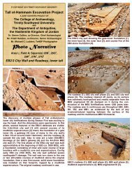
excavator of <str<strong>on</strong>g>Tall</str<strong>on</strong>g> Iktanu, states <strong>the</strong>re was no Roman or Byzantine occupati<strong>on</strong> <strong>the</strong>re. 9 Thatleaves <str<strong>on</strong>g>Tall</str<strong>on</strong>g> <str<strong>on</strong>g>el</str<strong>on</strong>g>-<str<strong>on</strong>g>Hammam</str<strong>on</strong>g> and <str<strong>on</strong>g>Tall</str<strong>on</strong>g> Nimrin. Since <strong>the</strong>re <strong>on</strong>ly are two unnamed sites <strong>on</strong> <strong>the</strong><strong>Madaba</strong> <strong>Map</strong> (due to damage), it seems clear that <strong>the</strong> nor<strong>the</strong>rn site is <str<strong>on</strong>g>Tall</str<strong>on</strong>g> Nimrin, and that <strong>the</strong>sou<strong>the</strong>rn site is <str<strong>on</strong>g>Tall</str<strong>on</strong>g> <str<strong>on</strong>g>el</str<strong>on</strong>g>-<str<strong>on</strong>g>Hammam</str<strong>on</strong>g>. The two sites are about 5 mi (8 km) apart. If <strong>the</strong>re is a flawin our reas<strong>on</strong>ing, we w<str<strong>on</strong>g>el</str<strong>on</strong>g>come fur<strong>the</strong>r input. James Flanagan, <strong>the</strong> excavator of <str<strong>on</strong>g>Tall</str<strong>on</strong>g> Nimrin,has, in fact, recognized that <str<strong>on</strong>g>Tall</str<strong>on</strong>g> Nimrin is lik<str<strong>on</strong>g>el</str<strong>on</strong>g>y <strong>the</strong> nor<strong>the</strong>rn site <strong>on</strong> <strong>the</strong> <strong>Madaba</strong> map. 10 Avi-Y<strong>on</strong>ah and Eugenio Alliata also identify Site One as <str<strong>on</strong>g>Tall</str<strong>on</strong>g> Nimrin. 11 By a process of<str<strong>on</strong>g>el</str<strong>on</strong>g>iminati<strong>on</strong>, it seems clear that <strong>the</strong> sou<strong>the</strong>rn site, Site Two, is <str<strong>on</strong>g>Tall</str<strong>on</strong>g> <str<strong>on</strong>g>el</str<strong>on</strong>g>-<str<strong>on</strong>g>Hammam</str<strong>on</strong>g>.Fig. 3—Roman Building (<str<strong>on</strong>g>Tall</str<strong>on</strong>g> <str<strong>on</strong>g>el</str<strong>on</strong>g>-<str<strong>on</strong>g>Hammam</str<strong>on</strong>g>,Jordan). This Roman building has not yet beenexcavated, but <strong>the</strong> massive Roman st<strong>on</strong>es andc<strong>on</strong>crete al<strong>on</strong>g with Roman pottery indicate thatthis was a Roman site not far from <strong>the</strong> lowerspring, which resides <strong>on</strong> <strong>the</strong> Early Br<strong>on</strong>ze Ag<str<strong>on</strong>g>el</str<strong>on</strong>g>ev<str<strong>on</strong>g>el</str<strong>on</strong>g> of <strong>the</strong> tall. David Graves is seen holding alarge piece of Byzantine pottery. © Micha<str<strong>on</strong>g>el</str<strong>on</strong>g>Luddeni.Identifiable FeaturesThe identifiable features of <strong>the</strong> porti<strong>on</strong> of <strong>the</strong><strong>Madaba</strong> <strong>Map</strong> in questi<strong>on</strong> include date palmtrees, 12 hot springs, and its proximity to <strong>the</strong>Jordan River and <strong>the</strong> Dead Sea. The indicati<strong>on</strong>of date palms is significant because, accordingto Diodorus Siculus (Bibl. Hist. 2.48–49),around <strong>the</strong> Dead Sea “<strong>the</strong> land is good forgrowing palms, wherever it happens to becrossed by rivers with usable water, or to beendowed with springs that can irrigate it” (cf.Theophrastus Pot. Hist. 2.5; Pliny Nat. Hist.5.9, 17; Tacitus Hist. 5.6). Such a supply offresh water exists at <str<strong>on</strong>g>Tall</str<strong>on</strong>g> <str<strong>on</strong>g>el</str<strong>on</strong>g>-<str<strong>on</strong>g>Hammam</str<strong>on</strong>g>. The<strong>Madaba</strong> <strong>Map</strong> identifies two <strong>the</strong>rmal springs atBaaras (Josephus Jewish War 7:180, 189;Eusebius Onomastic<strong>on</strong> 44:22ff; 112:17) 13 andKallirrhoë (Josephus Antiquity 17:171; JewishWar 1:657; Pliny Nat. Hist. 5:16) <strong>on</strong> <strong>the</strong> opposite (south) side of <strong>the</strong> Wadi Zarqa Ma’in. 14From <strong>the</strong> five date palms in <strong>the</strong> mosaic it would be reas<strong>on</strong>able to expect springs, and <strong>the</strong>rmalsprings around Site Two. <str<strong>on</strong>g>Tall</str<strong>on</strong>g> <str<strong>on</strong>g>el</str<strong>on</strong>g>-<str<strong>on</strong>g>Hammam</str<strong>on</strong>g> has two springs, and <strong>the</strong> name <str<strong>on</strong>g>Hammam</str<strong>on</strong>g> in Arabicactually means “spring” or “watersource.” One is found around <strong>the</strong> base of <strong>the</strong> upper tall in<strong>the</strong> Early Br<strong>on</strong>ze Age area, am<strong>on</strong>g Roman ruins. The sec<strong>on</strong>d spring locati<strong>on</strong> is across <strong>the</strong>modern road at <strong>the</strong> foot of a Roman fortificati<strong>on</strong>, <strong>on</strong> a hill where at least five cisterns are9 Kay Prag, The Shu'aib/Hisban Project, Jordan: A Regi<strong>on</strong>al Survey and Excavati<strong>on</strong>s Undertaken Since 1965. Cited 25January 2007. Online: http://www.cbrl .org.uk/shuaib.html.10 Flanagan, James W. and David W. McCreery. Virtual Nimrin: Occupati<strong>on</strong>al Sequence and Historical Overview. 2004.Cited 24 January, 2007. Online: http://www.case.edu/affil/nimrin/menu/nimrin.htm.11 Avi-Y<strong>on</strong>ah, <strong>Madaba</strong> Mosaic <strong>Map</strong>, 37; Eugenio Alliata, “The Legends of <strong>the</strong> <strong>Madaba</strong> <strong>Map</strong>,” in The <strong>Madaba</strong> <strong>Map</strong>Centenary: Trav<str<strong>on</strong>g>el</str<strong>on</strong>g>ling Through <strong>the</strong> Byzantine Umayyad Period. Proceedings of <strong>the</strong> Internati<strong>on</strong>al C<strong>on</strong>ference H<str<strong>on</strong>g>el</str<strong>on</strong>g>d inAmman 7–9 April 1997 (eds. Mich<str<strong>on</strong>g>el</str<strong>on</strong>g>e Piccirillo and Eugenio Alliata; Collectio Maior 40; Jerusalem: Studium BiblicumFranciscannum, 1998), 54.12 “Date palms (Phoenix dactylifera) are shown <strong>on</strong> <strong>the</strong> <strong>Madaba</strong> mosaic map as being grown around Scythopolis (bar<str<strong>on</strong>g>el</str<strong>on</strong>g>yshown <strong>on</strong> far left), Phasa<str<strong>on</strong>g>el</str<strong>on</strong>g>is, Jericho, Bethagla, Bethnambris, Livias, Calliroe, and Zoara.” N. F. Hepper, and Taylor J. E.“Date Palms and Opobalsam in <strong>the</strong> <strong>Madaba</strong> Mosaic <strong>Map</strong>,” PEQ 136.1 (2004): 35.13 Joan E. Taylor, Palestine in <strong>the</strong> Fourth Century A.D.: The Onomastic<strong>on</strong> by Eusebius of Caesarea (trans. by G. S. P.Freedman-Grenville; Jerusalem: Carta, 2003), 117.14 Herbert D<strong>on</strong>ner, The Mosaic <strong>Map</strong> of <strong>Madaba</strong>. An Introductory Guide (Palaestina antiqua 7; Kampen: Kok Pharos, 1992),39.4
identified. 15 The Roman ruins have been surveyed but not excavated. The <strong>Madaba</strong> <strong>Map</strong>identifies five palm trees <strong>on</strong> Site Two with two trees <strong>on</strong> <strong>the</strong> right and three <strong>on</strong> <strong>the</strong> left (Fig. 1).This would indicate a w<str<strong>on</strong>g>el</str<strong>on</strong>g>l-watered regi<strong>on</strong> c<strong>on</strong>sistent with <strong>the</strong> two springs and <strong>the</strong> proximityof <strong>the</strong> Wadi Kefrein. 16Byzantine Prominence of Site TwoThe vignette <strong>on</strong> <strong>the</strong> map represents two towers that appear to frame a “church” or o<strong>the</strong>r majorstructure with a roof and series of windows. There appears to have been Byzantine or EarlyRoman ruins <strong>on</strong> this site during <strong>the</strong> c<strong>on</strong>structi<strong>on</strong> of <strong>the</strong> Mosaic. Obviously Site Two wasknown to <strong>the</strong> mosaicist during <strong>the</strong> Byzantine period. This being <strong>the</strong> case, it would bereas<strong>on</strong>able to assume that <strong>on</strong>e should find some significant presence of occupati<strong>on</strong> during orimmediat<str<strong>on</strong>g>el</str<strong>on</strong>g>y preceding <strong>the</strong> Byzantine period.To date, no remnants of major Byzantine structures have been found at <str<strong>on</strong>g>Tall</str<strong>on</strong>g> <str<strong>on</strong>g>el</str<strong>on</strong>g>-<str<strong>on</strong>g>Hammam</str<strong>on</strong>g>, 17but during <strong>the</strong> 2007 excavati<strong>on</strong>s a small amount of Byzantine pottery was discovered near <strong>the</strong>first spring, in <strong>the</strong> regi<strong>on</strong> of <strong>the</strong> lower tall around <strong>the</strong> Roman ruins and massive Early Br<strong>on</strong>zeAge remains (Fig. 3). 18Fur<strong>the</strong>r excavati<strong>on</strong>s may reveal a significant Byzantine and/or Late Roman presence. If so,this would c<strong>on</strong>firm <strong>the</strong> presence of Byzantine/Roman structures c<strong>on</strong>sistent with <strong>the</strong> <strong>Madaba</strong><strong>Map</strong>. 19 We hope to execute a probe of this area in <strong>the</strong> 2008 excavati<strong>on</strong> seas<strong>on</strong>.Eusebius Pamphili, <strong>the</strong> bishop of Caesarea in Palestine (AD 275–339), wrote a four-partgeographical work called Onomastic<strong>on</strong> (AD 330). Eusebius’ Greek text introduces <strong>the</strong>Onomastic<strong>on</strong> with <strong>the</strong> words “On <strong>the</strong> Names of Places in Sacred Scripture.” 20 In short, it is ageographical dicti<strong>on</strong>ary of <strong>the</strong> Holy Land. The localizati<strong>on</strong> of wadies, mountains, and o<strong>the</strong>rgeographical features makes this a valuable asset when determining ancient locati<strong>on</strong>s. Someargue as w<str<strong>on</strong>g>el</str<strong>on</strong>g>l that <strong>the</strong> <strong>Madaba</strong> <strong>Map</strong> was str<strong>on</strong>gly dependent <strong>on</strong> <strong>the</strong> Onomastic<strong>on</strong>. However,C. Umhau Wolf points out that <strong>the</strong>re is no direct corr<str<strong>on</strong>g>el</str<strong>on</strong>g>ati<strong>on</strong> between <strong>the</strong> terminology used in<strong>the</strong> Onomastic<strong>on</strong> and <strong>the</strong> size of <strong>the</strong> locati<strong>on</strong>s.All <strong>the</strong> large walled cities with towers behind <strong>on</strong> <strong>the</strong> <strong>Madaba</strong> <strong>Map</strong> are called “city,” “largecity,” “famous city,” “metropolis” by Eusebius. For <strong>the</strong> smaller cities with <strong>on</strong>ly a fr<strong>on</strong>t wall andfour or five towers and for <strong>the</strong> larger villages with three or four towers c<strong>on</strong>nected by a wall,<strong>the</strong>re is no c<strong>on</strong>sistent corr<str<strong>on</strong>g>el</str<strong>on</strong>g>ati<strong>on</strong> with <strong>the</strong> Onomastic<strong>on</strong>’s terminology. (Nor is <strong>the</strong>re anyc<strong>on</strong>sistency in <strong>the</strong> various strata of <strong>the</strong> Onomastic<strong>on</strong> that can be checked out in <strong>the</strong> present stateof textual criticism and archaeological research.) Both Beersheba and Ekr<strong>on</strong> are called “large15 While it is probably a coincidence that <strong>the</strong>re are five palm trees <strong>on</strong> <strong>the</strong> Mosaic and five cisterns have been found, it isn<strong>on</strong>eth<str<strong>on</strong>g>el</str<strong>on</strong>g>ess an interesting parall<str<strong>on</strong>g>el</str<strong>on</strong>g>.16 The modern Kefrein dam indicates that this was a w<str<strong>on</strong>g>el</str<strong>on</strong>g>l-watered regi<strong>on</strong> in ancient, as w<str<strong>on</strong>g>el</str<strong>on</strong>g>l as modern, times.17 Since <strong>the</strong> site appears to have been last occupied in <strong>the</strong> Byzantine Era, any Byzantine ruins <strong>on</strong> <strong>the</strong> surface probablysuffered significantly from erosi<strong>on</strong>, scavenging for nearby structures, and modern bulldozing. This is a comm<strong>on</strong> problem atLevantine talls/t<str<strong>on</strong>g>el</str<strong>on</strong>g>ls.18 Collins, et al.<str<strong>on</strong>g>Tall</str<strong>on</strong>g> <str<strong>on</strong>g>el</str<strong>on</strong>g>-<str<strong>on</strong>g>Hammam</str<strong>on</strong>g> Activity Report 2007, 15.19 Rast citing Ab<str<strong>on</strong>g>el</str<strong>on</strong>g> states, “Also important for <strong>the</strong> Dead Sea Byzantine traditi<strong>on</strong>s about Lot and Sodom is <strong>the</strong> reference byStephen <strong>the</strong> Byzantine to a Bishop Severos of Sodom who attended <strong>the</strong> Nicaean Council.” Walter E. Rast, “Sodom and itsEnvir<strong>on</strong>s: Can Recent Archaeology Offer a Perspective?” NEASB 51(2006): 21; F. M. Ab<str<strong>on</strong>g>el</str<strong>on</strong>g>, Géographie de la Palestine 2(Paris: Etudes Bibliques, 1967), 468. Rast uses this informati<strong>on</strong>, that <strong>the</strong> Bishop of Sodom was present at <strong>the</strong> Sec<strong>on</strong>d Councilof Nicaea (AD 787), to argue for Byzantine Sodom being included in <strong>the</strong> area of Zoar <strong>on</strong> <strong>the</strong> <strong>Madaba</strong> <strong>Map</strong>; however, <strong>the</strong><strong>Map</strong> doesn’t have any o<strong>the</strong>r cities of <strong>the</strong> plain marked anywhere <strong>on</strong> <strong>the</strong> <strong>Map</strong> let al<strong>on</strong>e in <strong>the</strong> south. What this does indicate,however, is that Sodom existed in <strong>the</strong> Byzantine period. Is it possible that <strong>the</strong> name over Site Two read Sodom and thatBishop Severos of Sodom came from <str<strong>on</strong>g>Hammam</str<strong>on</strong>g>?20 Taylor, Onomastic<strong>on</strong>, 5.5
town” but are different as depicted <strong>on</strong> <strong>the</strong> map. Does this imply Ekr<strong>on</strong> had declined in <strong>the</strong>intervening centuries? Bethzur and Beth<str<strong>on</strong>g>el</str<strong>on</strong>g> are both simply villages in Eusebius, but Bethzur is alarge town <strong>on</strong> <strong>the</strong> map while Beth<str<strong>on</strong>g>el</str<strong>on</strong>g> is small, having <strong>on</strong>ly two towers and <strong>the</strong> c<strong>on</strong>necting wall.Does this accurat<str<strong>on</strong>g>el</str<strong>on</strong>g>y record <strong>the</strong> changed fortunes? 21Therefore, <strong>the</strong> corr<str<strong>on</strong>g>el</str<strong>on</strong>g>ati<strong>on</strong> between Eusebius and <strong>the</strong> <strong>Madaba</strong> <strong>Map</strong> may not be as h<str<strong>on</strong>g>el</str<strong>on</strong>g>pful asfirst thought. Just because Livias (see b<str<strong>on</strong>g>el</str<strong>on</strong>g>ow) is menti<strong>on</strong>ed repeatedly in <strong>the</strong> Onomastic<strong>on</strong> 22does not automatically mean that it may be found <strong>on</strong> <strong>the</strong> <strong>Madaba</strong> <strong>Map</strong>.<str<strong>on</strong>g>Tall</str<strong>on</strong>g> Nimrin’s Byzantine Occupati<strong>on</strong>The <str<strong>on</strong>g>Tall</str<strong>on</strong>g> Nimrin 23 excavati<strong>on</strong> report indicates that <strong>the</strong>re was a small Byzantine occupati<strong>on</strong><strong>the</strong>re, evident by some walls and plastered floors.Few ceramics were recovered from <strong>the</strong> H<str<strong>on</strong>g>el</str<strong>on</strong>g>lenistic era and no associated architecture.Likewise, no architectural remains can be dated to <strong>the</strong> Roman period. This may beexplained by modern bulldozing and dev<str<strong>on</strong>g>el</str<strong>on</strong>g>opment which have destroyed or removed<strong>the</strong> remains. Some Roman and Byzantine ceramics were found in several fill layers,but <strong>the</strong>y were mixed with Persian and Ir<strong>on</strong> materials because Roman/Byzantine pitshad been dug into <strong>the</strong> earlier lev<str<strong>on</strong>g>el</str<strong>on</strong>g>s. A few walls and plastered floors can be dated to<strong>the</strong> Byzantine period. 24The mosaic floor of a Byzantine church was discovered in 1980 during <strong>the</strong> c<strong>on</strong>structi<strong>on</strong> ofa house <strong>on</strong> <strong>the</strong> northwestern slope of <strong>the</strong> tall. The mosaic pavement was excavated byMich<str<strong>on</strong>g>el</str<strong>on</strong>g>e Piccirillo.In his 1982 report, Piccirillo reported a Byzantine church with a central and two sidenaves which toge<strong>the</strong>r measured 18.45 m x 13.52 m. The church had been in use formore than two centuries from <strong>the</strong> 6 th century C.E. through <strong>the</strong> 7 th and 8 th centuries andinto <strong>the</strong> Umayyad Period. 25Also, during <strong>the</strong> 1993 seas<strong>on</strong>, a horde of Byzantine coins was discovered from <strong>the</strong> reignsof emperors Valens, Valentinianus I, Leo, Zeno, Basciliscus, and Anastasius, from <strong>the</strong> middleof <strong>the</strong> fourth century to <strong>the</strong> early sixth century AD. 26 Schick, Flanagan, and McCreeryidentify <str<strong>on</strong>g>Tall</str<strong>on</strong>g> Nimrin <strong>on</strong> <strong>the</strong> <strong>Madaba</strong> <strong>Map</strong> as <strong>the</strong> o<strong>the</strong>r unnamed Site One, beside <strong>the</strong> unnamedSite Two, which we are identifying as <str<strong>on</strong>g>Tall</str<strong>on</strong>g> <str<strong>on</strong>g>el</str<strong>on</strong>g>-<str<strong>on</strong>g>Hammam</str<strong>on</strong>g>. 27 In our opini<strong>on</strong>, <strong>the</strong>y are correct in<strong>the</strong>ir evaluati<strong>on</strong>.<str<strong>on</strong>g>Tall</str<strong>on</strong>g> Iktanu’s Byzantine Occupati<strong>on</strong>Kay Prag gives <strong>the</strong> history of <strong>the</strong> excavati<strong>on</strong>s at <str<strong>on</strong>g>Tall</str<strong>on</strong>g> Iktanu from <strong>the</strong> first explorati<strong>on</strong> byS<str<strong>on</strong>g>el</str<strong>on</strong>g>ah Merrill in 1871 through <strong>the</strong> 1920’s and 30’s by A. Mall<strong>on</strong>. She notes that it wasincluded in fi<str<strong>on</strong>g>el</str<strong>on</strong>g>d surveys by N<str<strong>on</strong>g>el</str<strong>on</strong>g>s<strong>on</strong> Glueck in 1943, by Kay Wright (Prag) in 1965,21 C. Umhau Wolf, The Onomastic<strong>on</strong> of Eusebius Pamphili Compared with <strong>the</strong> Versi<strong>on</strong> of Jerome and Annotated, 1971.Cited 23 January, 2007. Online: http://www.tertullian.org/fa<strong>the</strong>rs/eusebius_<strong>on</strong>omastic<strong>on</strong>_01_intro.htm#The%20Onomastic<strong>on</strong>.22 Taylor, Onomastic<strong>on</strong>, 16, 18, 32, 33, 142.23 Beth-Nimrah (“house of abundant waters”) is menti<strong>on</strong>ed in Numbers 32:26.24 Flanagan and McCreery, Virtual Nimrin, n.p.; See also Taylor, Onomastic<strong>on</strong>, 121.25 Flanagan and McCreery, Virtual Nimrin, n.p.26 Flanagan and McCreery, Virtual Nimrin, n.p.27 Flanagan and McCreery, Virtual Nimrin, n.p.; Robert Schick, “Nor<strong>the</strong>rn Jordan: What Might Have Been in <strong>the</strong> <strong>Madaba</strong>Mosaic <strong>Map</strong>,” in The <strong>Madaba</strong> <strong>Map</strong> Centenary (eds. Mich<str<strong>on</strong>g>el</str<strong>on</strong>g>e Piccirillo and Eugenio Alliata; Jerusalem: Studium BiblicalFranciscan, 1999), 228.6
and by M. Ibrahim, K. Yassine and J. Sauer in 1976. Excavati<strong>on</strong>s were directed byKay Prag in 1966 <strong>on</strong> behalf of <strong>the</strong> British School of Archaeology in Jerusalem and in1987, 1989 and 1990 <strong>on</strong> behalf of <strong>the</strong> British Institute at Amman for Archaeology andHistory. The north hill was occupied in <strong>the</strong> Early Br<strong>on</strong>ze IB, Intermediate EarlyBr<strong>on</strong>ze-Middle Br<strong>on</strong>ze Age, Late Br<strong>on</strong>ze, Ir<strong>on</strong> Age and Persian periods. The southhill was partly occupied in <strong>the</strong> Early Br<strong>on</strong>ze IB and very extensiv<str<strong>on</strong>g>el</str<strong>on</strong>g>y in <strong>the</strong>Intermediate Early Br<strong>on</strong>ze-Middle Br<strong>on</strong>ze Age. There are occasi<strong>on</strong>al Roman,Byzantine, medieval, Ottoman and modern sherds <strong>on</strong> <strong>the</strong> site, but no evidence foroccupati<strong>on</strong> at <strong>the</strong>se periods (1965). 28So while some Roman or Byzantine pottery has been found <strong>on</strong> <strong>the</strong> site, Prag maintains that<strong>the</strong>re was no Roman or Byzantine settlement. Therefore, as previously menti<strong>on</strong>ed, <str<strong>on</strong>g>Tall</str<strong>on</strong>g> Iktanuis not a viable candidate. Besides, it is far too small for <strong>the</strong> site <strong>on</strong> <strong>the</strong> <strong>Madaba</strong> map.Taylor also comments <strong>on</strong> <strong>the</strong> occupati<strong>on</strong> at <str<strong>on</strong>g>Tall</str<strong>on</strong>g> Iktanu. She states thatT<str<strong>on</strong>g>el</str<strong>on</strong>g>l Iktanu is an excavated site at which a single occupati<strong>on</strong>, and extensive and w<str<strong>on</strong>g>el</str<strong>on</strong>g>lplanned settlement of <strong>the</strong> Middle Br<strong>on</strong>ze I (EB-MB, EB IV) culture was revealed.Ahar<strong>on</strong>i’s identificati<strong>on</strong> [of <str<strong>on</strong>g>Tall</str<strong>on</strong>g> Iktanu as Livias] is, <strong>the</strong>refore, extrem<str<strong>on</strong>g>el</str<strong>on</strong>g>y unlik<str<strong>on</strong>g>el</str<strong>on</strong>g>y. 29She is clear that <strong>the</strong>re is no Roman or Byzantine occupati<strong>on</strong>.Not C<strong>on</strong>sistently IdentifiedThe prominent works <strong>on</strong> <strong>the</strong> <strong>Madaba</strong> <strong>Map</strong>, identify <strong>the</strong> unnamed Site Two with variouspossibilities. In 1954 Micha<str<strong>on</strong>g>el</str<strong>on</strong>g> Avi-Y<strong>on</strong>ah, in his book The <strong>Madaba</strong> Mosaic <strong>Map</strong>, identified<strong>the</strong> Site Two as Beth-jeshimoth (Khirbet Suweima) and Site One as Khirbet <str<strong>on</strong>g>el</str<strong>on</strong>g> Kefrein 30 or<str<strong>on</strong>g>Tall</str<strong>on</strong>g> Rama 31 :Across <strong>the</strong> Jordan and opposite Galgala we notice above <strong>the</strong> gaz<str<strong>on</strong>g>el</str<strong>on</strong>g>le <strong>the</strong> fragmentaryrepresentati<strong>on</strong> of a locality, with <strong>the</strong> trunks of two palm trees to <strong>the</strong> right [Site One].To judge from its positi<strong>on</strong> <strong>on</strong> <strong>the</strong> map this might refer ei<strong>the</strong>r to Ab<str<strong>on</strong>g>el</str<strong>on</strong>g> (Khirbet <str<strong>on</strong>g>el</str<strong>on</strong>g>Kafrein) or to Livias-Bethramtha (T<str<strong>on</strong>g>el</str<strong>on</strong>g>l Rama). Ano<strong>the</strong>r equally nam<str<strong>on</strong>g>el</str<strong>on</strong>g>ess village [SiteTwo] is situated between this place and <strong>the</strong> Dead Sea. If <strong>the</strong> latter is meant torepresent Beth-jeshimoth (Onomastic<strong>on</strong> 48:7), <strong>the</strong>n <strong>the</strong> nor<strong>the</strong>rn village would beBeth-ramtha, and Ab<str<strong>on</strong>g>el</str<strong>on</strong>g> might have been located in <strong>the</strong> lost part of <strong>the</strong> pavementfur<strong>the</strong>r to <strong>the</strong> north-east. Possibly, however, Ab<str<strong>on</strong>g>el</str<strong>on</strong>g> was not represented at all. Eusebiusmenti<strong>on</strong>ed Beth-ramtha (Livias) seven times (Onomastic<strong>on</strong> 48:13–15), while hementi<strong>on</strong>s Ab<str<strong>on</strong>g>el</str<strong>on</strong>g> but does not locate it. 32Later Avi-Y<strong>on</strong>ah states “Above it ([Aen<strong>on</strong>-Sapsaphas and ano<strong>the</strong>r shrub] i.e. eastwards)stands a biggish village surrounded by palm trees; as suggested above its most lik<str<strong>on</strong>g>el</str<strong>on</strong>g>y28 Kay Prag, The Shu'aib/Hisban Project, Jordan: A Regi<strong>on</strong>al Survey and Excavati<strong>on</strong>s Undertaken Since 1965. Cited 25January 2007. Online: http://www.cbrl.org.uk/shuaib.html. Since <strong>the</strong>re is little evidence of LB occupati<strong>on</strong> in <strong>the</strong> entireeastern Jordan valley (kikkar), we b<str<strong>on</strong>g>el</str<strong>on</strong>g>ieve that <strong>the</strong> evidence for such cited by Prag merits re-examinati<strong>on</strong>. It appears thatIktanu’s <strong>on</strong>ly Br<strong>on</strong>ze Age occupati<strong>on</strong> represented by architectural remains is <strong>the</strong> Intermediate Br<strong>on</strong>ze Age (formerly EB IVthrough MB I).29 Taylor, Onomastic<strong>on</strong>, 142.30 Harris<strong>on</strong> states that “<strong>the</strong> area of this site [<str<strong>on</strong>g>Tall</str<strong>on</strong>g> <str<strong>on</strong>g>el</str<strong>on</strong>g>-<str<strong>on</strong>g>Hammam</str<strong>on</strong>g>] was nearly a hundred times bigger than that of <str<strong>on</strong>g>Tall</str<strong>on</strong>g> <str<strong>on</strong>g>el</str<strong>on</strong>g>-Kefrein.” Harris<strong>on</strong>, “Shittim,” NIDBA, 414. Therefore, <str<strong>on</strong>g>Tall</str<strong>on</strong>g> Kefrein can be reas<strong>on</strong>ably <str<strong>on</strong>g>el</str<strong>on</strong>g>iminated <strong>on</strong> <strong>the</strong> basis of it being toosmall compared with <str<strong>on</strong>g>Tall</str<strong>on</strong>g> <str<strong>on</strong>g>el</str<strong>on</strong>g>-<str<strong>on</strong>g>Hammam</str<strong>on</strong>g>. The site is presently being excavated by a Greek team, but it is unknown at this timeif <strong>the</strong>y have uncovered any Early Roman or Byzantine pottery or ruins.31 Beth-Ramtha, Betharam (Josh 13:27), a city of <strong>the</strong> tribe of Gad, near <strong>the</strong> Jordan, called Bethramphtha by <strong>the</strong> Syrians.32 Avi-Y<strong>on</strong>ah, <strong>Madaba</strong> Mosaic <strong>Map</strong>, 37.7
identificati<strong>on</strong> is with Beth-jeshimoth (Khirbet Suweime).” 33In Herbert D<strong>on</strong>ner’s 1992 book The Mosaic <strong>Map</strong> of <strong>Madaba</strong>, he identifies Site Two withLivias, <str<strong>on</strong>g>Tall</str<strong>on</strong>g> Iktanu, or <str<strong>on</strong>g>Tall</str<strong>on</strong>g> Rama:The Old Testament town was called Beth-Haram, later <strong>on</strong>, under <strong>the</strong> Roman emperorAugustus, it was called Livias or Julias. 34 It is identical with <str<strong>on</strong>g>Tall</str<strong>on</strong>g> Iktanu and <strong>the</strong> smallbut remarkable <str<strong>on</strong>g>Tall</str<strong>on</strong>g> ar-Rama. 35 It appears to be situated at <strong>the</strong> upper course of WadiZarqa Ma’in which runs into <strong>the</strong> Dead Sea after its turn.” 36Alliata, in an article <strong>on</strong> <strong>the</strong> identificati<strong>on</strong> of <strong>the</strong> sites in The <strong>Madaba</strong> <strong>Map</strong> Centenary,identifies Site Two with Betharam (Josh 13:27) or Bethramphtha, now Livias or <str<strong>on</strong>g>Tall</str<strong>on</strong>g> Rama. 37Robert Schick, in an article <strong>on</strong> nor<strong>the</strong>rn Jordan in The <strong>Madaba</strong> <strong>Map</strong> Centenary, proposesBeth Jeshimoth (Suweima) as Site Two:Small porti<strong>on</strong>s of two o<strong>the</strong>r unlab<str<strong>on</strong>g>el</str<strong>on</strong>g>led city vignettes survive. A variety of suggesti<strong>on</strong>shave been made for <strong>the</strong>ir identificati<strong>on</strong>. The city vignette above <strong>the</strong> gaz<str<strong>on</strong>g>el</str<strong>on</strong>g>le to <strong>the</strong> left[Site One] could be Ab<str<strong>on</strong>g>el</str<strong>on</strong>g> (Khirbat al-Kafrein) or Livias/Beth-Ramtha (T<str<strong>on</strong>g>el</str<strong>on</strong>g>l Rama), orperhaps Beth Nimrin (T<str<strong>on</strong>g>el</str<strong>on</strong>g>l Nimrin), while <strong>the</strong> city vignette above <strong>the</strong> gaz<str<strong>on</strong>g>el</str<strong>on</strong>g>le to <strong>the</strong>right [Site Two] could be Beth Jeshimoth (Suweima). 38As we have proven earlier, <strong>on</strong>ly <str<strong>on</strong>g>Tall</str<strong>on</strong>g> Nimrin and <str<strong>on</strong>g>Tall</str<strong>on</strong>g> <str<strong>on</strong>g>el</str<strong>on</strong>g>-<str<strong>on</strong>g>Hammam</str<strong>on</strong>g> are logical candidatesfor <strong>the</strong>se sites.LiviasD<strong>on</strong>ner identifies Site Two as Livias or <str<strong>on</strong>g>Tall</str<strong>on</strong>g> Rama. 39 The name of <strong>the</strong> site was changed byHerod to h<strong>on</strong>or Augustus. 40 However, <strong>the</strong>re is no evidence directly linking <strong>the</strong> unnamed<strong>Madaba</strong> <strong>Map</strong> site and Livias, o<strong>the</strong>r than general speculati<strong>on</strong> and <strong>the</strong> fact that Eusebiusmenti<strong>on</strong>ed Livias in his writings seven times. Whileit is <strong>the</strong> comm<strong>on</strong>ly accepted view am<strong>on</strong>g scholars that <strong>the</strong> <strong>Madaba</strong> <strong>Map</strong> dependsheavily <strong>on</strong> Eusebius’ gazetteer of biblical places, <strong>the</strong> Onomastik<strong>on</strong>. . . it is al (sic; at)least c<strong>on</strong>ceivable that, ra<strong>the</strong>r than <strong>the</strong> <strong>Madaba</strong> <strong>Map</strong> mechanically depending <strong>on</strong> <strong>the</strong>Onomastik<strong>on</strong>, both <strong>the</strong> Onomastik<strong>on</strong> and <strong>the</strong> prototype of <strong>the</strong> map may have derivedfrom a comm<strong>on</strong> cultural lore. 41Of course, just because Eusebius is aware of Livias, it does not mean that this site isLivias. However, if <str<strong>on</strong>g>Tall</str<strong>on</strong>g> <str<strong>on</strong>g>el</str<strong>on</strong>g>-<str<strong>on</strong>g>Hammam</str<strong>on</strong>g> were proven to be Livias, this would not hurt our33 Also known as Bethasimouth. Taylor, Onomastic<strong>on</strong>, 121; cf. Eusebius Onomastic<strong>on</strong> 48:7; N<str<strong>on</strong>g>el</str<strong>on</strong>g>s<strong>on</strong> Glueck, “Some AncientTowns in <strong>the</strong> Plains of Moab,” BASOR 91 (1943): 13–18.34 Eusebius, Onomastic<strong>on</strong> 48:14-15 (ca. AD 330); Avi-Y<strong>on</strong>ah, <strong>Madaba</strong> Mosaic <strong>Map</strong>, 37; D<strong>on</strong>ner, Mosaic <strong>Map</strong> of <strong>Madaba</strong>,39; Schick, “Nor<strong>the</strong>rn Jordan,” 228.35 D<strong>on</strong>ner’s use of <strong>the</strong> term remarkable is an interesting descriptor as <strong>the</strong>re is nothing remarkable about Ramma ei<strong>the</strong>rarchaeologically or in size.36 D<strong>on</strong>ner, Mosaic <strong>Map</strong> of <strong>Madaba</strong>, 39.37 Alliata, “Legends of <strong>the</strong> <strong>Madaba</strong> <strong>Map</strong>,” 54; cf. Eusebius Onomastic<strong>on</strong> 48:14–15.38 Schick, “Nor<strong>the</strong>rn Jordan,” 228.39 Beth-Ramtha, Betharam, (Josh 13:27), a city of <strong>the</strong> tribe of Gad near <strong>the</strong> Jordan, known to <strong>the</strong> Syrians as Bethramphtha.40 Eusebius, Onomastic<strong>on</strong> 48:14-15 [ca. AD 330]; Jerome 49:12-13 [ca. AD 390]; Avi-Y<strong>on</strong>ah, <strong>Madaba</strong> Mosaic <strong>Map</strong>, 37;Schick, “Nor<strong>the</strong>rn Jordan,” 228; D<strong>on</strong>ner, Mosaic <strong>Map</strong> of <strong>Madaba</strong>, 39.41 Leah Di Segni, The Onomastik<strong>on</strong> of Eusebius and <strong>the</strong> <strong>Madaba</strong> <strong>Map</strong>. Cited 23 January, 2007. Online:http://198.62.75.1/www1/ofm/ mad/articles/DiSegniOnomastic<strong>on</strong>.html.8
argument in <strong>the</strong> least. 42Beth Jeshimoth (Suweima)Both Avi-Y<strong>on</strong>ah and Schick identify Site Two with Beth Jeshimoth (Suweima orSuwaymah). Number 33:49 t<str<strong>on</strong>g>el</str<strong>on</strong>g>ls us that “There <strong>on</strong> <strong>the</strong> plains of Moab <strong>the</strong>y camped al<strong>on</strong>g <strong>the</strong>Jordan from Beth Jeshimoth to Ab<str<strong>on</strong>g>el</str<strong>on</strong>g> Shittim” (NIV). This was <strong>on</strong>e of <strong>the</strong> borders for Sih<strong>on</strong>king of <strong>the</strong> Amorites (Jos 12:2-3) and is described as a Moabite fr<strong>on</strong>tier town in Ezeki<str<strong>on</strong>g>el</str<strong>on</strong>g> 25:9.The modern town of Suwaymah is <strong>on</strong> <strong>the</strong> o<strong>the</strong>r side of <strong>the</strong> Wadi al-Zarqa Ma‘in, much too farsouth <strong>on</strong> <strong>the</strong> Dead Sea to be identified with Site Two. If Beth Jeshimoth is identified withmodern day Suweima or Suwaymah, 43 which appears lik<str<strong>on</strong>g>el</str<strong>on</strong>g>y to us, <strong>the</strong>n it is certainly not SiteTwo.C<strong>on</strong>clusi<strong>on</strong><str<strong>on</strong>g>Tall</str<strong>on</strong>g> <str<strong>on</strong>g>el</str<strong>on</strong>g>-<str<strong>on</strong>g>Hammam</str<strong>on</strong>g> has flourished throughout history because of its defensibility, abundantwater, and proximity to <strong>the</strong> Kings’ Highway, a major trade route linking Egypt andMesopotamia. <str<strong>on</strong>g>Tall</str<strong>on</strong>g> <str<strong>on</strong>g>el</str<strong>on</strong>g>-<str<strong>on</strong>g>Hammam</str<strong>on</strong>g> is lik<str<strong>on</strong>g>el</str<strong>on</strong>g>y <strong>the</strong> Shittim of <strong>the</strong> Late Br<strong>on</strong>ze Age, 44 where <strong>the</strong>Isra<str<strong>on</strong>g>el</str<strong>on</strong>g>ites encamped before entering Canaan (Num 33:49; Jos 2:1; 3:1). Fur<strong>the</strong>rmore, <strong>the</strong>Middle Br<strong>on</strong>ze Age city <strong>on</strong> <strong>the</strong> upper tall is lik<str<strong>on</strong>g>el</str<strong>on</strong>g>y <strong>the</strong> Sodom 45 of Genesis 13-19, 46 while <strong>the</strong>huge Ir<strong>on</strong> II city at <str<strong>on</strong>g>Tall</str<strong>on</strong>g> <str<strong>on</strong>g>el</str<strong>on</strong>g>-<str<strong>on</strong>g>Hammam</str<strong>on</strong>g> may prove to be <strong>on</strong>e of Solom<strong>on</strong>’s tw<str<strong>on</strong>g>el</str<strong>on</strong>g>ve administrativecenters. Perhaps it was also <strong>the</strong> Livias of New Testament times. If our argument is valid, that<str<strong>on</strong>g>Tall</str<strong>on</strong>g> <str<strong>on</strong>g>el</str<strong>on</strong>g>-<str<strong>on</strong>g>Hammam</str<strong>on</strong>g> is <strong>the</strong> unidentified Site Two <strong>on</strong> <strong>the</strong> <strong>Madaba</strong> <strong>Map</strong>, <strong>the</strong>n we just placedseveral important cities and sites <strong>on</strong> <strong>the</strong> <strong>Map</strong>—<strong>the</strong> <strong>Madaba</strong> <strong>Map</strong>.___________________________BibliographyAb<str<strong>on</strong>g>el</str<strong>on</strong>g>, F. M. Géographie de la Palestine. Vol. 2. Paris: Etudes Bibliques, 1967.Alliata, Eugenio. “The Legends of <strong>the</strong> <strong>Madaba</strong> <strong>Map</strong>.” Pages 47–101 in The <strong>Madaba</strong> <strong>Map</strong>Centenary: Trav<str<strong>on</strong>g>el</str<strong>on</strong>g>ling Through <strong>the</strong> Byzantine Umayyad Period. Proceedings of <strong>the</strong>42 Egeria, <strong>the</strong> fourth century Spanish pilgrim who trav<str<strong>on</strong>g>el</str<strong>on</strong>g>ed <strong>the</strong> Holy Land between AD 381-384, describes trav<str<strong>on</strong>g>el</str<strong>on</strong>g>ing to Liviasand seeing <strong>the</strong> city directly across from Jericho from <strong>the</strong> top of Mount Nebo. She describes that <strong>the</strong> Sodomites lived to th<str<strong>on</strong>g>el</str<strong>on</strong>g>eft of Livias with Zoar (Segor) also visible from Mount Nebo. Egeria, The Pilgrimage of E<strong>the</strong>ria (trans. and eds. M.L.McClure and C. L. F<str<strong>on</strong>g>el</str<strong>on</strong>g>toe; L<strong>on</strong>d<strong>on</strong>: Society for Promoting Christian Knowledge,1919), 19, 23. From Mount Nebo <str<strong>on</strong>g>Tall</str<strong>on</strong>g> <str<strong>on</strong>g>el</str<strong>on</strong>g>-<str<strong>on</strong>g>Hammam</str<strong>on</strong>g> is also visible.43 Also known as Bethasimouth. Taylor, Onomastic<strong>on</strong>, 121.44 Willis J. Beecher, “Ab<str<strong>on</strong>g>el</str<strong>on</strong>g>-Shittim,” in The Internati<strong>on</strong>al Standard Bible Encyclopedia 1 (ed. James Orr; Grand Rapids, MI:Eerdmans, 1949), 7; Harris<strong>on</strong>, “Shittim,” NIDBA, 413.45 Dr. Steven Collins from Trinity Southwest University seems to be in <strong>the</strong> process of supplanting <strong>the</strong> view that Sodom and<strong>the</strong> o<strong>the</strong>r Cities of <strong>the</strong> Plain were located at <strong>the</strong> sou<strong>the</strong>rn end of <strong>the</strong> Dead Sea, dem<strong>on</strong>strating, in fact, that Sodom was in <strong>the</strong>north at <str<strong>on</strong>g>Tall</str<strong>on</strong>g> <str<strong>on</strong>g>el</str<strong>on</strong>g>-<str<strong>on</strong>g>Hammam</str<strong>on</strong>g>. Collins, et al. <str<strong>on</strong>g>Tall</str<strong>on</strong>g> <str<strong>on</strong>g>el</str<strong>on</strong>g>-<str<strong>on</strong>g>Hammam</str<strong>on</strong>g> Activity Report 2007; S. Collins, The Search for Sodom andGomorrah (Albuquerque: TSU Press, 2006); “The Geography of <strong>the</strong> Cities of <strong>the</strong> Plain,” BRB 2.1 (2002): 1–17; “AChr<strong>on</strong>ology for <strong>the</strong> Cities of <strong>the</strong> Plain,” BRB 2.8 (2002): 1–9; “The Architecture of Sodom,” BRB 2.14 (2002): 1–9; “Termsof Destructi<strong>on</strong> for <strong>the</strong> Cities of <strong>the</strong> Plain,” BRB 2.16 (2002): 1–8; “Explorati<strong>on</strong>s <strong>on</strong> <strong>the</strong> Eastern Jordan Disk,” BRB 2.18(2002): 1–28; “Rethinking <strong>the</strong> Locati<strong>on</strong> of Zoar: An Exercise in Biblical Geography.” BRB 6.3 (2006): 1–5; “Forty SalientPoints <strong>on</strong> <strong>the</strong> Geography of <strong>the</strong> Cities of <strong>the</strong> Kikkar,” BRB 7.1 (2007): 1–7; “Reassessing <strong>the</strong> Term hakikkar in Nehemiah asBearing <strong>on</strong> <strong>the</strong> Locati<strong>on</strong> of <strong>the</strong> Cities of <strong>the</strong> Plain,” BRB 7.3 (2007): 1–4; “If You Thought You Knew <strong>the</strong> Locati<strong>on</strong> ofSodom and Gomorrah…Think Again.” BRB 7.4 (2007): 1–6. See also William M. Thoms<strong>on</strong>, The Land and <strong>the</strong> Book:Sou<strong>the</strong>rn Palestine and Jerusalem (New York: Harper and Bro<strong>the</strong>rs, 1882), 371–76.46 The Koran also menti<strong>on</strong>s Sodom (Surah 11:74–83). In <strong>the</strong> Koran <strong>the</strong> name of Lot is Lut and <strong>the</strong> name of Abraham isIbrahim. Also, <strong>the</strong> Koran does not record that Lot’s wife was turned into a pillar of salt but that she ended in a terrible fateand was left behind.9
Glueck, N<str<strong>on</strong>g>el</str<strong>on</strong>g>s<strong>on</strong>. “Some Ancient Towns in <strong>the</strong> Plains of Moab.” Bulletin of <strong>the</strong> AmericanSchool of Oriental Research 91 (1943): 13–18.Harris<strong>on</strong>, R. K. “Shittim.” Pages 413–14 in The New Internati<strong>on</strong>al Dicti<strong>on</strong>ary of BiblicalArchaeology. Edited by Edward M. Blaiklock and R. K. Harris<strong>on</strong>. Grand Rapids:Z<strong>on</strong>dervan, 1983.Hepper, N. F. and Taylor J. E. “Date Palms and Opobalsam in <strong>the</strong> <strong>Madaba</strong> Mosaic <strong>Map</strong>.”Palestine Explorati<strong>on</strong> Quarterly 136.1 (2004): 35–44.Josephus, Flavius. The Works of Flavius Josephus. Edited by H. St. J. Thackeray et al., 9vols. Loeb Classical Library. Cambridge MA: Harvard University, 1926.Manfredi, J. “Callirhoé et Baarou dans la mosaïque géographique de <strong>Madaba</strong>.” Revuebiblique 12.2 (1903) : 166–71.Pliny <strong>the</strong> Elder. Natural History. Translated by H. Rackham, et al., 10 vols. Loeb ClassicalLibrary. Cambridge MA: Harvard University, 1938.Prag, Kay. The Shu’aib/Hisban Project, Jordan: A Regi<strong>on</strong>al Survey and Excavati<strong>on</strong>sUndertaken Since 1965. [Cited 25 January 2007]. Online:http://www.cbrl.org.uk/shuaib.html.Rast, Walter E. “Sodom and its Envir<strong>on</strong>s: Can Recent Archaeology Offer a Perspective?”Near East Archaeological Society Bulletin 51(2006): 19–26.Schick, Robert, “Nor<strong>the</strong>rn Jordan: What Might Have Been in <strong>the</strong> <strong>Madaba</strong> Mosaic <strong>Map</strong>.” Page228 in The <strong>Madaba</strong> <strong>Map</strong> Centenary, Edited by Mich<str<strong>on</strong>g>el</str<strong>on</strong>g>e Piccirillo and Eugenio Alliata.Jerusalem: Studium Biblical Franciscan, 1999.Tacitus, Publius Corn<str<strong>on</strong>g>el</str<strong>on</strong>g>ius. The Complete Works of Tacitus. Edited by Moses Hadas.Translated by Alfred John Church and William Jacks<strong>on</strong> Brodribb. New York: ModernLibrary, 1942.Taylor, Joan E. Palestine in <strong>the</strong> Fourth Century A.D.: The Onomastic<strong>on</strong> by Eusebius ofCaesarea. Translated by G. S. P. Freedman-Grenville. Jerusalem: Carta, 2003.Theophrastus. Enquiry into Plants: De Historia Plantarum. I, Books 1-5. Loeb ClassicalLibrary. Cambridge, MA: Harvard University Press, 1916.Thoms<strong>on</strong>, William M. The Land and <strong>the</strong> Book: Sou<strong>the</strong>rn Palestine and Jerusalem. NewYork: Harper and Bro<strong>the</strong>rs, 1882.Wolf, C. Umhau. The Onomastic<strong>on</strong> of Eusebius Pamphili Compared with <strong>the</strong> Versi<strong>on</strong> ofJerome and Annotated, 1971. [Cited 23 January, 2007]. Online:http://www.tertullian.org/fa<strong>the</strong>rs/eusebius<strong>on</strong>omastic<strong>on</strong>_01_intro.htm#The%20Onomastic<strong>on</strong>.11