1976 July-September - NASA Ames History Office
1976 July-September - NASA Ames History Office
1976 July-September - NASA Ames History Office

You also want an ePaper? Increase the reach of your titles
YUMPU automatically turns print PDFs into web optimized ePapers that Google loves.
National Aeronautics and<br />
Space Ad ministration<br />
<strong>Ames</strong> Research Center<br />
Moffett Field Caldornia 94035<br />
VOLUME XVIlt NUMBER 23<br />
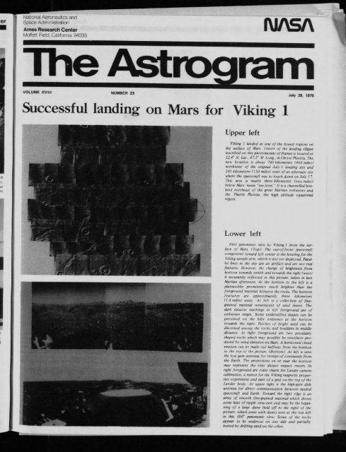
Successful landing on Mars for Viking 1<br />
Upper left<br />
Jury 29. <strong>1976</strong><br />
Viking ] landed in one of the lowest regions on<br />
the surface of Mars Center of the landing elhpse<br />
instTibed on this photomosaie of frames is located at<br />
224° N Lat. 4Z5~ W L~mg inChr)sePlanitia The<br />
new location i~ about 740 kilometers (460 miles)<br />
northwest of the original <strong>July</strong> 4 landing site and<br />
240 kilometers (150 miles) west of an alternate site<br />
where the spacecraft was to touch dowt~ on Jul) 17<br />
This area ~ nearl) three kilometers (two miles)<br />
below Mars ’ mean "sea level "" It is a ehannelled lowland<br />
northeast of the great /¢Jartlan ~,olcanoes and<br />
the Tharsis Plateau the high altitude equatorial<br />
region.<br />
Lower left<br />
First panoramw view by Vtk#zg l from the surthee<br />
o/ Mars tTop) 7he out-otZJbeas spacecraft<br />
component toward left center is the housing for the<br />
Viking sample arm, which is not yet depto3 ed. Parallel<br />
lines #1 the SkF are an art(tat! and are not real<br />
features. However. the change of brightness from<br />
horiz~m toward~ -~enith and towards the right (west)<br />
L~ accurately reflected tn this picture, taket~ in late<br />
Martian afternoon At the horizon to the left is a<br />
plateau-like prominence much brighter than the<br />
/oreground material between the rocka. The horizon<br />
features are approximateZ) three k~tometers<br />
(1 8 miles) away At left ts a collection of finegrained<br />
mater~al remmLwent of sand dunes¯ The<br />
dark ~inuous markings in le/t .if>reground are of<br />
unknown origin. Some unidentd?ed shapes can be<br />
perceived on the hilh eminence at the horizon<br />
towards the right Pa&he.~ ~l bright sand can be<br />
discerned amg~ttg the r(~c ks and bouMers in middle<br />
distance In r~gh: toregmund are two peculiarh<br />
.rhaped r~wks which may posribh be vent~tacts produced<br />
bl’ wind abrasum on Mars: .4 horizontal chmd<br />
stratum c~tn be rrusde out halfway O’om the horLzon<br />
to the top of the picture eBottomt At le¢t is seet~<br />
the low gaJ~? antenna f~r receipt ojcommands From<br />
the Earth The pro/ection~ cm or near the hurL-on<br />
ma)" represdnt lhe rolls alL, rant ltnpact craters [tl<br />
right .{bregr~mnd are color charts .l}~r Lander camera<br />
calibration, a mirror tbr the |qking magnetic propertWs<br />
cvperPm’nt and part of a grid on the top of the<br />
Lander bad!..4t upper right is the high-gain dish<br />
antetma /or direct commut~icatiotl betweetr latlded<br />
spacecraJ? and Earth Toward the right edge is an<br />
array ~ff smooth free-grained material wtmh shows<br />
some hint of ripple structure and may be the beginning<br />
of a large dune field oft to the right t~.f the<br />
picture, which joins with dunes seen at the top h’ft<br />
in this 300° panorami~ flew. Sume of the rocks<br />
appear to be undercut on one side and parttalh<br />
buried b~ drifting sand on the othet~