INFORMATION DOCUMENT - DWA Home Page
INFORMATION DOCUMENT - DWA Home Page
INFORMATION DOCUMENT - DWA Home Page

Create successful ePaper yourself
Turn your PDF publications into a flip-book with our unique Google optimized e-Paper software.
WHERE TO GET<br />
MORE <strong>INFORMATION</strong><br />
The 3 key reports:<br />
❏ Metsi Consultants (2002) Report<br />
678-F-001, Summary of Main<br />
Findings for Phase 1 Development<br />
❏ Metsi Consultants (2002) Report<br />
678-F-002, Additional Scenarios and<br />
Production of a New Final Report<br />
(Vol. II)<br />
❏ S. Klasen (2002) The Costs and<br />
Benefits of Changing Instream Flow<br />
Requirements<br />
are available on the following<br />
websites:<br />
❏ www.lhwp.org.ls.<br />
❏ www.lesotho.gov.ls<br />
❏ www.dwaf.gov.za<br />
❏ www.sametsi.com<br />
Hard copies of these reports are<br />
lodged for public inspection at<br />
the following venues:<br />
❏ LHDA Library, 3rd Floor, Post<br />
Office Building, Kingsway, Maseru,<br />
Lesotho<br />
❏ National Environmental<br />
Secretariat Library, Post Office<br />
Building, Maseru<br />
❏ National University of Lesotho<br />
Library, Roma, Lesotho<br />
❏ <strong>DWA</strong>F Library, 3rd Floor Sedibeng<br />
Bldg, Schoeman St, Pretoria<br />
❏ World Bank office, Pro-Equity<br />
Court, 1250 Pretorius Street,<br />
Pretoria<br />
❏ University of Cape Town Library,<br />
Rondebosch, Cape Town<br />
❏ Public Information Center, World<br />
Bank, 1818 H Street NW,<br />
Washington, DC<br />
Should you wish to read further,<br />
a full set of Metsi Consultants<br />
Contract 648 reports are lodged<br />
at:<br />
❏ LHDA Library, 3rd Floor, Post<br />
Office Building, Kingsway, Maseru,<br />
Lesotho<br />
❏ <strong>DWA</strong>F Library, 3rd Floor,<br />
Sedibeng Bldg, Schoeman St,<br />
Pretoria, South Africa<br />
❏ National University of Lesotho<br />
Library, Roma, Lesotho<br />
Treaty Minimum Release Scenario<br />
This is the scenario generated by application of the minimum release conditions<br />
specified in the Treaty and is at the opposite end of the range from Minimum<br />
Degradation in terms of water requirements. Conceptually, the scenario differs<br />
from that above in that the volumes of delivery water are first specified and<br />
consequential river conditions then assessed.<br />
Design Limitation Scenario<br />
This is a scenario based on the practical limitations of flow releases imposed by<br />
the designs of the Phase 1 structures. In terms of volumes of water releases, it is<br />
between the above two scenarios.<br />
Fourth (Intermediate) Scenario<br />
This scenario was selected to fall between the Treaty Minimum and Design<br />
Limitation scenarios and to provide a reference point between the former (legally<br />
defined and highest water delivery, but most severe environmental and socioeconomic<br />
impacts) and the latter (possible within engineering constraints, but<br />
likely to have high impacts on water and revenues).<br />
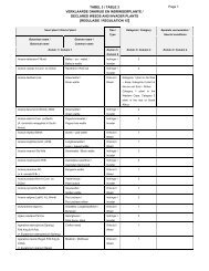
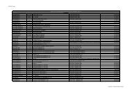
Summary of Findings<br />
Hydrological changes<br />
The Table below gives a global picture of the hydrological changes that are predicted<br />
to occur under each of the four scenarios. It is from the changes in the river<br />
hydrology or flow regime that all other predicted changes are derived. This overview<br />
presents the overall amount of water available to downstream ecosystems on an<br />
annual basis, as a proportion of mean annual runoff (MAR), this being an estimate<br />
of the average amount of water draining from the catchment in a year.<br />
Table 1: Historical MAR, the annual volume allocated to the river and the percentage of<br />
historical MAR that this represents, under each of the four scenarios at each IFR site for<br />
LHWP Phase 1 development. Shaded sites represent reaches immediately downstream of<br />
the dams in Phase 1a and 1b<br />
IFR<br />
Site<br />
Historical<br />
MAR<br />
Minimum<br />
Degradation<br />
Scenario<br />
MCM a -l MCM a -l %MAR MCM a -l %MAR MCM a -l %MAR MCM a -l %MAR<br />
1 87 51 59 35 40 35 40 31 36<br />
2 554 366 66 22 4 184 33 97 18<br />
3 774 436 56 128 17 315 41 227 29<br />
4 1572 866 55 831 53 831 53 831 53<br />
5 1924 1194 62<br />
6 3330 2171 65<br />
Treaty<br />
Minimum<br />
Scenario<br />
Design<br />
Limitation<br />
Scenario<br />
Fourth<br />
Scenario<br />
Flows sufficient for Minimum Degradation<br />
7 355 231 65 48 13 126 35 77 22<br />
8 592 397 67 158 27 254 43 195 33<br />
Site 1 = Matsoku R, immediately downstream of Matsoku Weir (30km)<br />
Site 2 = Malibamats’o R, immediately downstream of Katse Dam (20km)<br />
Site 7 = Senqunyane R immediately downstream of Mohale Dam (90km)<br />
Site 3 = Malibamats’o R at Paray, downstream of confluence with Matsoku R (35km)<br />
Site 4 = Senqu R at Sehonghong, representing Senqu between confluences of Malibamats’o and<br />
Tsoelike rivers (125km)<br />
Site 5 = Senqu R at Whitehills, between confluences of Tsoelike and Senqunyane rivers (85km)<br />
Site 6 = Senqu R at Seaka Bridge, from confluence with Senqunyane to South African border (140km)<br />
Site 8 = Senqunyane R upstream of the confluence with the Senqu R, from confluence with Lesobeng<br />
R to the confluence with the Senqu R (40km).<br />
7