DARPA's LAGR and UPI Programs
DARPA's LAGR and UPI Programs
DARPA's LAGR and UPI Programs

Create successful ePaper yourself
Turn your PDF publications into a flip-book with our unique Google optimized e-Paper software.
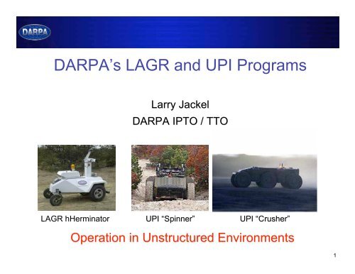
DARPA’s <strong>LAGR</strong> <strong>and</strong> <strong>UPI</strong> <strong>Programs</strong><br />
<strong>LAGR</strong> hHerminator<br />
Larry Jackel<br />
DARPA IPTO / TTO<br />
<strong>UPI</strong> “Spinner Spinner”<br />
<strong>UPI</strong> “Crusher Crusher”<br />
Operation in Unstructured Environments<br />
1
Desired Characteristics for UGVs<br />
• Autonomous operation over many km, beyond line of sight<br />
(no human intervention)<br />
- We are making progress<br />
• Safe operation near people <strong>and</strong> other vehicles<br />
- Just starting to be addressed<br />
• Graceful fallback to human teleoperation when autonomous<br />
operation fails<br />
- Often not possible because of comms limitations<br />
• Guestimates of required comms-<br />
Simple environments (e.g. road with no traffic) - at least 1Mbps<br />
< 100 msec latency to maintain vehicle speed<br />
Complex environments (city driving, off road driving) at least 10Mbps<br />
perhaps 1Gbps < 30 msec latency<br />
We need to make autonomy work<br />
2
How autonomous navigation is done today<br />
Sense the environment, usually with LADAR<br />
Useful range is typically less than 50m<br />
Create a 3-D model of the space with solid <strong>and</strong><br />
empty volume elements<br />
Identify features in the environment:<br />
Ditches, Grass, Water, Rocks, Trees, Etc.<br />
Create a 2-D map of safe areas (black) <strong>and</strong><br />
dangerous areas (red)<br />
Run a path planning algorithm to decide on the next move<br />
toward the goal, staying in the “black” areas<br />
Move the vehicle<br />
Repeat<br />
Tree<br />
Positive obstacle<br />
Canopy<br />
Overhang<br />
3
Autonomous Navigation Today<br />
(Results from DARPA PerceptOR Program, Completed 2004)<br />
Good performance, provided the environment is not too cluttered or<br />
complex<br />
Performance degrades in<br />
complex environments;<br />
much worse than human<br />
RC operation<br />
- Unreliable object recognition<br />
- Minimal scene analysis<br />
Too much reliance on nonadaptive,<br />
brittle, h<strong>and</strong>crafted<br />
algorithms<br />
- No “common sense”: Generally can’t learn from mistakes<br />
4
Challenges for Autonomous Navigation<br />
• Develop robust obstacle detection<br />
- e.g. differentiate between rocks vs tall<br />
compressible bushes<br />
- Need adaptive systems that learn<br />
• Overcome limitations of near-sighted<br />
sensing (LADAR or Stereo)<br />
- Avoid getting trapped in cul-de-sacs<br />
• Determine location <strong>and</strong> orientation<br />
without high-accuracy GPS<br />
- Possible solution:<br />
Visual Odometry<br />
• Scene Underst<strong>and</strong>ing<br />
- “See” the path without<br />
explicit range-finding<br />
or object recognition<br />
Goal<br />
Obstacle<br />
Vehicle<br />
5
<strong>LAGR</strong> Goals –<br />
Learning Applied to Ground Robots<br />
(<strong>LAGR</strong>)<br />
Specific:<br />
- Advance the frontier of autonomous navigation of unmanned<br />
ground vehicles (UGVs) in complex terrain<br />
- Tech transfer to DARPA <strong>UPI</strong> program<br />
General:<br />
- Advance machine vision<br />
- Apply machine learning to a new domain<br />
- Couple machine vision with machine learning<br />
6
Problem:<br />
How can we measure progress in UGV autonomy?<br />
No st<strong>and</strong>ard hardware<br />
- Many different UGV designs<br />
- Pick a “st<strong>and</strong>ard” UGV<br />
No a priori measure of the difficulty of course<br />
- Depends on the mechanical capability of the robot <strong>and</strong> the complexity<br />
of the terrain<br />
- “Calibrate” the course by measuring performance of<br />
baseline navigation software on the chosen st<strong>and</strong>ard UGV<br />
No st<strong>and</strong>ard database for testing <strong>and</strong> training<br />
- Difficult to compare results from different courses<br />
- Measure performance of multiple systems at a specific site<br />
7
DARPA <strong>LAGR</strong> Program<br />
• Numerous performers, common vehicle<br />
• Performance measured against PerceptOR baseline code<br />
• Monthly government tests<br />
at different sites<br />
• Encourage code sharing<br />
between performers<br />
Bonus – shared experience<br />
among performers: a new<br />
community of interest<br />
Applied Perception<br />
Georgia Tech<br />
JPL<br />
Net-Scale<br />
NIST<br />
U Penn<br />
SRI<br />
Stanford<br />
U Colorado<br />
U Idaho<br />
U Missouri<br />
U Central<br />
Florida<br />
8
WAAS GPS<br />
on a<br />
collapsible<br />
mount<br />
E-Stop<br />
Bumper with<br />
dual limit<br />
switches<br />
Differential<br />
drive<br />
<strong>LAGR</strong> Platform Front View<br />
Dual<br />
stereo<br />
cameras<br />
IR<br />
Rangefinder<br />
9
Approach<br />
<strong>LAGR</strong> Testing<br />
- Teams send software to DARPA test staff<br />
- A single, GPS waypoint is specified as the goal<br />
- Each team is given three runs using a DARPA robot<br />
• Learn from one run to the next – obstacle types <strong>and</strong> location<br />
- The tests are unrehearsed, teams have not seen the course<br />
- Teams watch <strong>and</strong> comment on tests via live video, audio, <strong>and</strong> diagnostics<br />
As tests progressed, the Government team refined tests to isolate specific<br />
aspects of perception <strong>and</strong> navigation<br />
10
Test 3 <strong>and</strong> 4 May, June 2005, Ft Belvoir<br />
• Test designed to encourage long-range vision<br />
Path<br />
Start Box<br />
<strong>and</strong> planning<br />
• Bright orange snow fences + natural obstacles<br />
• Starting to see working learning systems<br />
• Most systems still immature<br />
Goal Ellipse<br />
First<br />
encounter<br />
with Fence<br />
11
Test 4, June 05<br />
First evidence of long range vision<br />
(video)<br />
12
Test 5, Hanover NH Aug 05<br />
Poor GPS coverage, steep hills, lush forest<br />
Tested trail following<br />
Location of goal waypoint encouraged vehicle to leave trail <strong>and</strong> bushwhack<br />
though thick woods<br />
Some teams performed well<br />
13
Test 7, Ft Belvoir October 05<br />
(test of long range vision)<br />
Straight-line path<br />
“Rail”<br />
Most reasonable path<br />
Some teams built orange snow fence detectors – too bad!<br />
14
Test 7, Ft Belvoir October 05<br />
goal<br />
Direct route to goal leads to cul-de-sac<br />
15
Typical Approach to Learned Long-Range Perception<br />
Sense local obstacles using<br />
stereo, bumper hits, or wheel<br />
slippage<br />
Note optical qualities of<br />
local obstacles <strong>and</strong> nonobstacles<br />
Look for similar optical<br />
qualities at a distance<br />
Infer obstacle / not obstacle<br />
16
Typical behavior at<br />
the beginning of a<br />
team’s first run<br />
Test 7, Ft Belvoir October 05<br />
Most teams quickly learned that the low pines were not traversable<br />
<strong>and</strong> then successfully detected <strong>and</strong> avoided the pines at long range<br />
17
API & NIST Test 7<br />
NIST:<br />
A neural net maps feature vectors to terrain cost at distances up to 28 m<br />
API : Color is indexed to 3-D features that in turn indicate cost<br />
~25 meters<br />
Robot<br />
position<br />
API Cost map<br />
18
Test 8, November 05, Ft Belvoir<br />
Learning From Example<br />
Training data:<br />
Logs of vehicle<br />
teleoperated following<br />
white line<br />
Results:<br />
3 teams followed the<br />
line in Test 8, only one<br />
(API) succeeded without<br />
hints from programmers<br />
19
Test 9, December 05, San Antonio TX<br />
Navigation along path<br />
through dry scrub<br />
- minimal color cues<br />
- some teams now performing<br />
much better than the Baseline<br />
Start<br />
Goal<br />
20
Score<br />
0.50<br />
0.45<br />
0.40<br />
0.35<br />
0.30<br />
0.25<br />
0.20<br />
0.15<br />
0.10<br />
0.05<br />
0.00<br />
Score Statistics Tests 4, 6, 7, 8<br />
Teams<br />
Mean<br />
of 12<br />
Runs<br />
Baseline<br />
Score = minimum possible time to complete course / corrected time on course<br />
corrected time = actual time if course completed<br />
= max allowed time x fraction of course completed<br />
21
<strong>LAGR</strong> Summary<br />
Excellent progress toward achieving program goals:<br />
- Demonstrated learning from experience <strong>and</strong> example<br />
- Demonstrated ground classification beyond range of stereo<br />
Tests are being designed to force (as much as possible)<br />
non-incremental solutions<br />
- Test design is challenging<br />
- Additional tests on mono vision, long-range vision, <strong>and</strong><br />
learning from example in Phase I<br />
Just scratched the surface on scene underst<strong>and</strong>ing<br />
Go / No Go set for May ’06 for Phase II<br />
Port of best results to <strong>UPI</strong> in Phase II<br />
22
DARPA’s <strong>UPI</strong> Program<br />
Prime integrator: Carnegie Mellon University’s NREC<br />
3-year effort (ends early FY08)<br />
23
Combine:<br />
+ Prior terrain data<br />
+ State-of-the-art perception<br />
based navigation<br />
<strong>UPI</strong> Overview<br />
+ Vehicle with extreme mobility<br />
Result:<br />
A cutting edge system that<br />
serves as a pathfinder for<br />
large, autonomous UGVs<br />
24
Obstacle Avoidance is Easier When the<br />
World Has Fewer Obstacles<br />
Why are there no people near this robot?<br />
25
<strong>UPI</strong> Status<br />
• <strong>UPI</strong> Phase I Go/No-Go was exceeded<br />
- Required autonomous performance<br />
in complex terrain<br />
>1.27 m/s average speed<br />
< 1 intervention / 2km<br />
- Actual performance in test<br />
1.42 m/s average speed<br />
1 intervention in 4.5 km test course<br />
Test was conducted the first time<br />
the vehicle was on the on the course<br />
No course-specific “tuning”<br />
• 1 st Crusher vehicle operational 12/05<br />
2 nd Crusher vehicle operational 3/06<br />
Spinner,<br />
Yakima, Ft Hood<br />
Crusher Highlights –<br />
Exp 3 & 4 – Short<br />
Video<br />
Crusher, Ft Hood<br />
26
RGB Cameras<br />
- Apply color pixel to<br />
each LADAR point<br />
Novatel IMU<br />
Autonomous<br />
Navigation<br />
Software<br />
- Blade server used for<br />
perception processing<br />
Autonomy System v1<br />
LADAR – 8 COTS SICK LMS Units - 108 pts/sec<br />
4 vertically scanning, 4 horizontally scanning<br />
Stereo Camera Pairs – 6 COTS Bumblebee pairs<br />
Identical to <strong>LAGR</strong><br />
27
Reliability <strong>and</strong> Safety<br />
• Deadman switch on RC control<br />
- Radio comms failure stops vehicle<br />
- No people allowed near vehicle<br />
• Numerous vehicle “health” monitors<br />
• Hybrid-electric drive with dual battery stacks<br />
• Mechanical <strong>and</strong> electric regeneration braking<br />
• 6 wheels <strong>and</strong> suspensions<br />
- Need only 4 to drive<br />
• Blade server computer<br />
• 8 Sick ladars, many cameras<br />
• IMU + GPS<br />
• Super tough tires<br />
• Designed for easy repair<br />
• Lots of spare parts trucked to field tests<br />
28
Course 1<br />
• Nine waypoints<br />
• Waypoint-to-Waypoint = 3.8km<br />
• As driven by HMMWV = 4.5km<br />
- Follows treeline <strong>and</strong> lower<br />
contour of plateau<br />
- Mostly off-road with some<br />
trails<br />
- Many washes<br />
- Mixes of tall vegetation <strong>and</strong><br />
trees<br />
- Climbs road at end<br />
- Waypoints do not allow direct<br />
point-to-point traverse<br />
- Higher DTED allows more<br />
aggressive planned routes<br />
Ft. Hood Test Course 1<br />
Plain<br />
start<br />
Course 2<br />
Forested Plateau<br />
Course 1<br />
Escarpment<br />
finish<br />
29
• Cost Map Example<br />
• Course 1 Run<br />
Videos from Ft. Hood<br />
30
<strong>UPI</strong> 2.0 Vehicle – Crusher<br />
• Completed shakeout at NREC on<br />
25 NOV<br />
• Tested at FT Hood –175km traveled<br />
- RC & waypoint following<br />
• Base Weight – 13,000lb<br />
- Fuel<br />
- No payload, perception<br />
- Hybrid - 60kW turbo-diesel<br />
• Phase II focus – Crusher<br />
- Autonomy port to Crusher<br />
- Reducing profile of sensor mast<br />
Crusher @ Ft. Hood<br />
31
<strong>UPI</strong> Plans for Phase II<br />
• Increase autonomous speed to > 2.5 m/s in complex terrain<br />
• Use <strong>UPI</strong> vehicles to develop realistic requirements <strong>and</strong><br />
operational scenarios for large, high-mobility UGVs<br />
- Quarterly experiments<br />
• June 06 - Ft. Carson, CO<br />
• Sept 06 - Ft. Knox, KY<br />
• Use <strong>UPI</strong> vehicles as testbeds for new perception methods<br />
- <strong>LAGR</strong><br />
Extreme mobility + advanced perception + prior terrain data<br />
defines <strong>and</strong> exp<strong>and</strong>s the envelope for autonomous UGVs<br />
32
Sneak Preview:<br />
Learning<br />
Locomotion<br />
Starts Tuesday<br />
Identical vehicles to numerous teams<br />
Train <strong>and</strong> test on Govt terrains boards fitted<br />
with external vision systems<br />
Decouple the control problem from the perception problem<br />
33
Summary: Building Robust Systems<br />
• Design vehicles with high intrinsic mobility<br />
• Use scene underst<strong>and</strong>ing to allow perception beyond limits<br />
imposed by range finders<br />
• Incorporate prior GIS data to allow long-range planning<br />
• Replace h<strong>and</strong>-crafted algorithms with learned systems<br />
• Or: Figure out a way to have guaranteed wideb<strong>and</strong>, low<br />
latency comms <strong>and</strong> a human operator available whenever<br />
needed for teleoperation<br />
• Safety <strong>and</strong> driving near moving objects are topics for new<br />
research<br />
35