

Baldwin County Wetland Conservation Plan - Alabama Department ...
Baldwin County Wetland Conservation Plan - Alabama Department ...
Baldwin County Wetland Conservation Plan - Alabama Department ...

Create successful ePaper yourself
Turn your PDF publications into a flip-book with our unique Google optimized e-Paper software.
<strong>Baldwin</strong> <strong>County</strong> <strong>Wetland</strong> <strong>Conservation</strong> <strong>Plan</strong> Final Summary Document<br />
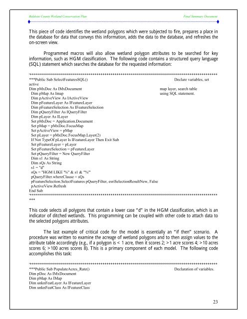
This piece of code identifies the wetland polygons which were subjected to fire, prepares a place in<br />
the database for data that conveys this information, adds the data to the database, and refreshes the<br />
on-screen view.<br />
Programmed macros will also allow wetland polygon attributes to be searched for key<br />
information, such as HGM classification. The following code contains a structured query language<br />
(SQL) statement which searches the database for the requested information:<br />
'*********************************************************************************************<br />
***Public Sub SelectFeaturesSQL() Declare variables, set<br />
active<br />
Dim pMxDoc As IMxDocument map layer, search table<br />
Dim pMap As Imap using SQL statement.<br />
Dim pActiveView As IActiveView<br />
Dim pFeatureLayer As IFeatureLayer<br />
Dim pFeatureSelection As IFeatureSelection<br />
Dim pQueryFilter As IQueryFilter<br />
Dim pLayer As ILayer<br />
Set pMxDoc = Application.Document<br />
Set pMap = pMxDoc.FocusMap<br />
Set pActiveView = pMap<br />
Set pLayer = pMxDoc.FocusMap.Layer(2)<br />
If Not TypeOf pLayer Is IFeatureLayer Then Exit Sub<br />
Set pFeatureLayer = pLayer<br />
Set pFeatureSelection = pFeatureLayer<br />
Set pQueryFilter = New QueryFilter<br />
Dim s1 As String<br />
Dim sQs As String<br />
s1 = "d"<br />
sQs = "HGM LIKE '%" & s1 & "%'"<br />
pQueryFilter.whereClause = sQs<br />
pFeatureSelection.SelectFeatures pQueryFilter, esriSelectionResultNew, False<br />
pActiveView.Refresh<br />
End Sub<br />
'*********************************************************************************************<br />
***<br />
This code selects all polygons that contain a lower case “d” in the HGM classification, which is an<br />
indicator of ditched wetlands. This programming can be coupled with other code to attach data to<br />
the selected polygons attributes.<br />
The last example of critical code for the model is essentially an “if then” scenario. A<br />
procedure was written to examine the acreage of wetland polygons and to then assign values to the<br />
attribute table accordingly (e.g., if a polygon is < 1 acre, then it scores 2; >1 acre scores 4; >10 acres<br />
scores 6; >100 acres scores 8). This is a primary component of each model. The following code<br />
accomplishes this task:<br />
'*********************************************************************************************<br />
***Public Sub PopulateAcres_Rate() Declaration of variables.<br />
Dim pDoc As IMxDocument<br />
Dim pMap As IMap<br />
Dim unknFeatLayer As IFeatureLayer<br />
Dim unknFeatClass As IFeatureClass<br />
23


