MUTUAL WATER COMPANY SUBSCRIPTION AGREEMENT ...
MUTUAL WATER COMPANY SUBSCRIPTION AGREEMENT ...
MUTUAL WATER COMPANY SUBSCRIPTION AGREEMENT ...
You also want an ePaper? Increase the reach of your titles
YUMPU automatically turns print PDFs into web optimized ePapers that Google loves.
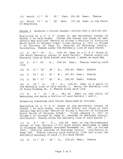
(3) North 21 ° 35 ' 30 " East 391.84 Feet; Thence<br />
(4) North 75 ° 41 ' 20" West<br />
of Beginning.<br />
757.26 Feet to the Point<br />
Parcel 3 Assessor's Parcel Number: 243- 221- 002 & 243-221- 021<br />
Beginning at a 2 " x 2" stake at the Northwest corner of<br />
Parcel 2 as said Stake, Corner and Parcel are shown on that<br />
certain Map entitled "Record of Survey a Portion of Victorine<br />
Ranch South of Malpaso Creek" filed January 4, 1957 in Volume<br />
5 of Surveys at Page 91, Records of Monterey County,<br />
California, Thence along the Northerly line of said Parcel<br />
( 1) s. 80 ° 29 I<br />
E.' 1203 . 29 Feet to a 2" X 2" Stake at<br />
the North Easterly corner of said Parcel; Thence along the<br />
Easterly line of Said Parcel and Parcel 1 shown on said Map<br />
(2) s. 8 0 OS<br />
line<br />
( 3) N. 7 3 ° 58 I 40 II w<br />
( 4) s . 79 ° 42 ' 45 II w<br />
( 5) s. 84 ° 47 ' 45 II w<br />
I<br />
E. ' 548.84 Feet; Thence leaving said<br />
• I 205.83 Feet; Thence<br />
• I 297.83 Feet; Thence<br />
• I 242 . 62 Feet; Thence<br />
(6) S. 64 ° 15 ' 18 " W., 439.91 Feet to a point on<br />
the Westerly l ine of said Parcel 1 , Being the Easterly line<br />
of State Highway No. 1; Thence along said line<br />
( 7 ) N . 8 ° 0 5 W . , 9 6 1 . 3 5 Feet to the point of<br />
beginning and being a Portion of said Parcels 1 and 2.<br />
Excepting therefrom that Parcel described as follows :<br />
Beginning at a 2" X 2" Stake at the Northeast corner of<br />
Parcel 1 as said Stake, Corner and Parcel are shown on that<br />
certain Map entitled "Record of Survey a Portion of Victorine<br />
Ranch South of Mal paso Creek", filed J anuary 4, 195 7 in<br />
Volume 5 of Surveys at Page 91, Records of Monterey County,<br />
California; Thence along the Easterly line of said parcel 1<br />
( 1) S . 8 ° OS ' E . , 262.68 Feet to the Northeastern<br />
cor ner of that Certain 17.913 Acre Parcel described in Deed<br />
to Florence Zellhoefer recorded November 24, 1961 in Volume<br />
2205, Official Records of Monterey County, California at<br />
Page 284, Thence Leaving said Easterly line and along the<br />
Northerly Boundary of said 17.913 Acre Parcel<br />
( 2) N. 7 3 ° 58 ' 4 0 " W. , 2 0 5 . 8 3 Feet; Thence<br />
Page 3 of 5


